Abstract
The aim of this contribution is to illustrate a methodology for the protection and management of the building heritage, adding to the historical documentary investigations, a careful phase of survey and a conscious geometric and informational modeling of the pre-existence. The focus of this work was the Tower of Vietri sul Mare: a significant example of the architectural defense strategies adopted in Salerno in the 16th century. In fact, through the creation of digital models, it would be facilitated the management of the volumetric evolution that this tower has undergone over time, ensuring a greater accessibility and an easier understanding of the transformations it has suffered.
1. Introduction
The conservation and the dissemination of architectural heritage is due in a territory rich in historic testimonies such as the coast of Salerno. The discipline of Drawing contributes strongly to the knowledge phase of this heritage and is the fundamental vehicle for preserving and handing down the past belong to us. In this regard, the following paper is part of a more general study aimed at identifying an innovative working methodology for the interpretation of the constructed and for the generation of infographic models useful for the analysis of historical artifacts.
The case of study, in particular, is focus on the Tower of Marina of Vietri sul Mare; a building of the 16th century and belonging to a more elaborate coastal defense project adopted by the ancient Principality of Citra in the viceroy era. The richness of coastal cities has always attracted the interest of the corsairs and pirates of the time, also facilitated by the particular orographic features of the place that allowed the boats to “hide” and favor the attacks. Therefore it was necessary to provide the implementation of defense plans to safeguard and protect populations and centers from such incursions.
Through previous studies, as well as direct archival and iconographic surveys, it was possible to identify the volumetric evolution of this tower from the XVI century to the present. The digital and three-dimensional representation would then extend the reading of the information acquired to a wider public, facilitating the diffusion and understanding of the transformations that took place over time. However, new tools and strategies are necessary to protect these valuable resources: in this sense the adoption of the BIM methodology would allow defining not only the shapes in the three dimensions, but also the easier to read and reinterpret the architecture by those involved in the work. However, such tools as historical heritage, as well as in the case of Historic Building Information Modeling, can also be used as building-related information databases: the geometric and alphanumeric accuracy of the product models provides reliable and usable views for future operations.
To achieve the purpose of this work, the authors pursued four main phases: the study and review of literature that characterizes the tower, architectural survey, modeling in function of historical evolution, add information to the model.
In particular, modern low-cost photogrammetric techniques have been used: the shoots have been implemented in ReCap Photo for a multi-image modeling photogrammetric. This 3D model was the main source for the next three-dimensional modeling in Revit.
Finally, the inclusion of data on the costal building—territorial localization—and specific data to the individual additions and overlaps that have happened over the years—materials, functions, and needs—it allowed an overview of the architectural that we study so that the generated model will also produce an indispensable database for the revision of architectural heritage for its conservation, management and protection.
One of the difficulties spotted was the digital restitution of the graphic and alphanumeric properties associated with the digital model. For this reason, it is fundamental the theme of LOD for the model of the non-canonical objects libraries that populate the tower.
2. Brief Chronological Observation
The development of piracy in the Mediterranean Sea has very ancient origins, probably coinciding with the very beginning of the first boats and navigation. However, the first problems appear following the formation of the first great states and the compromise of their security. A time of respite from these sea scenes was during the Roman period with the control of the entire Mediterranean perimeter. After the collapse of the empire, the security of the territories ceased and the coastal towns became the favorite place for the sea raiders [1]. A further worsening of the situation took place around the 7th century AD followed by Islamic expansion and the consequent conflict between Christians and Muslims, which embitter always more until almost completely overcoming the problems of ancient piracy. Thus, the so called “corsair war” began (from the Greek Kurseuo, “sacking” and “corsair”), a real raid action of the coasts of Salerno by the Islamic world.
Over time and the following of various vicissitudes, the severity of the situation inevitably implicate the need to plan appropriate interventions to oversee and defend its territory. A first defensive plan took place around the end of the 13th century under the Charles of Anjou dynasty (Charles V) where the first coastal towers were made but only for short stretches of territory.
The idea was to provide a visual connection, with fire and smoke, between the various towers to set up an adequate counteroffensive and warn the people to the sighting of the adversary. The next Aragon dynasty further increased this plan by building new towers and incorporating some of the existing ones.
Nevertheless, the corsair phenomenon continued, and around the 16th century, the Viceroy elaborated an imposing defense plan, called “torreggiamento”. In particular, two were the projects: the first elaborated by Don Pedro de Toledo (1532) and the second by Don Pedro Afan de Ribera (1563). In the first case, the universities themselves (municipality in southern Italy that arose during the Longobard period) had to take care of the realization of the fortification buildings; but the economic difficulties encountered implicate the non-implementation of the plan. On 22 February 1553, following the death of Pedro de Toledo, the completion of the project was delegated to his successor Don Pedro Afan de Ribera. The latter, in order to ensure its realization, directly charged its technical and administrative authority for the execution of the plan, but the interventions had to be financed by individual universities. After about a decade, though not coincident with the initial project, the new defensive system had been completed and was already active [2].
The end of these incursions along the coasts of the Kingdom of Naples would only be after the great amphibious operation carried out by France and concluded with the conquest of Algiers in 1830. Thus began the abandonment and the dismantling of many towers that lost their function works of fortification; in particular, following the edict of Vittorio Emanuele II of 1860, numerous artefacts were auctioned.
3. Case Study
The Tower of the Marina or Vito Bianchi, is one of the largest viceroy towers built along the Amalfi Coast of 1564. It is a tower with five embrasures made by the Cava University, the city from which came from the most important builders of the maritime towers of the sixteenth century. The main function was the barrage to carry out a task of signal the arrival of the enemies and to prevent from landing. It was built near the sea, but following a series of natural events—the flood of October 1954 and the violent storm of 1987—is today integrated into the urban context of the city. The tower, furthermore, over time has undergone a series of transformations until the present shape. Originally, around 1565, for its defensive function the tower was made of large size and with a square of dimension sufficient for the installation of the cannons. The inviolability of the tower was guaranteed by the absence of openings for the first six meters and with an entrance that took place at the second level in the direction of the city. According to a watercolour of the nineteenth century, visible in the publication of L. Santoro [3] (p. 132), access was guaranteed by a fixed staircase, located near the tower and connected by a drawbridge.
As still visible today, the Tower of the Marina has a pyramid shape and develops internally on two large rooms. The ground floor, a square base and covered with a barrel vault with a sea-mount directrix, was the sole function of a cistern for collecting rainwater. The upper level, initially accessed only by the above mentioned external staircase, still has a square plant and is covered by a barrel vault, but with an orthogonal directrix to the underlying, it was used to lodge the tower. The upper terrace, whereas, was accessible by an inner staircase built in the thickness of the wall which often also served as a storage of food and ammunition. On the top of this square, there were bartizans that is the room with barrel vault, once the site for the territory guard (Figure 1).
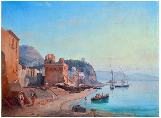
Figure 1.
Unknown author, Marina di Vietri, XVI century; oil on canvas Coll. Villa Guariglia, Via Nuova Raito. Raito di Vietri sul Mare (SA).
Between the end of the eighteenth and the beginning of the nineteenth century, the tower was transferred to the Battalion of the Invalidi to repulse, along with other towers on the coast, the phenomenon of contraband. Probably this is the time when some changes to the tower are made with the addition of more volumes on the squares: “Tower of Vietri, half a mile from the prec. (T. d’Albori) with a piece of bronze and a small Mojana pie, is gutted by Invalidi Soldiers, consider repairs for 86 ducats. The expenses are attributed to the University of Cava, which holds five Towers and the five added” [4] (p. 270).
These extensions are visible from some of the draws by Clarkson Frederick Stanfield (1793–1867) during his stay in the Amalfi Coast in November 1838. The painting A View of Vietri in the Gulf of Salerno, now keep at the Royal Collection in London (Figure 2), clearly shows the changes made by the tower.
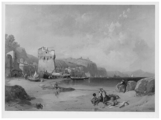
Figure 2.
Clarkson Stanfield (1793–1867), A View of Vietri in the Gulf of Salerno, 1840; oil on canvas Coll. Royal Collection Trust/© Her Majesty Queen Elizabeth II 2017.
Subsequently, in 1860, it was used as a customs and was not introduced in the list of the abandoned towers in the decree of Vittorio Emanuele II.
From what is visible in the pencil drawing by Richard Dölker (Figure 3), it is probably at the end of the nineteenth and early twentieth centuries that the tower undergoes further variations: adding an entryway to the base and eliminating the drawbridge for to facilitate the entrance to the upper floors through an external stairway near the wall of the construction.
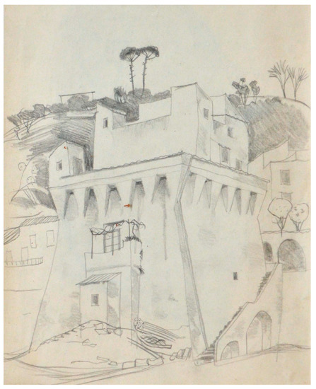
Figure 3.
Richard Dölker (1896–1955), Tower di Vietri sul Mare, Pencil Drawing; Coll. Raccolta Arti Applicate di Villa De Ruggiero, via Nazionale 102. Nocera Superiore (SA).
In the following years, the tower became the seat of the Fiscal Police with the addition, on the monitoring terrace, of other volumes suitable to use the artifact for the new function and a balcony that is support by a large arc connected at the wall (Figure 4).
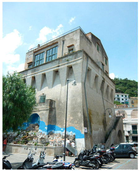
Figure 4.
Tower of Marina di Vietri, 2017.
4. Photogrammetric Survey and Post-Processing
After the first historical-architectural research followed a photogrammetric survey completed with the realization of 181 photos. The instrumentation used is a Canon EOS600D Digital Reflex characterized by a sensor CMOS APS-C 18 Megapixel and an ISO sensitivity of 100 to 6400. In order to obtain technical drawings of scale 1:50 that are characterized by errors less than 1 cm, we have proceeded with an adequate value of Ground Sample Distance during the survey. Specifically, we worked with a focal length of 18 mm at a distance of 7m, achieving approximately 0.17 cm/pixel GSD value.
However are different the problems encountered during the acquisition that interfered with the quality of the final model and the accessibility of information: presence of artifacts surrounding the tower that generate shadows on it; absence of sufficient space for the realization of parallel photos near the north facade; presence of vegetation adjacent to the main facade and finally the height of the building.
The data gained during this survey was then developed with free software ReCap Photo, a cloud service from the Autodesk manufacturing company, which bases its work on automating the reverse modeling process. It is therefore an online software that can automatically detect homologous points on the photos, returning their spatial position and eventually generating a textured 3D model. Despite the advantage of remote processing and the ability to use low performing computers, the restitution’s intervention is very limited by only introducing a measure to scale the object and choose the quality as well as the export formats.
Unlike laser scanner techniques, the methodology employed, in addition to being economically advantageous, provides as output a much more manageable file in the next modeling phase thanks to the less size in Mb, reducing, in contrast, the accuracy of the survey and therefore of the final model. The digital image thus obtained (Figure 5) was the starting point for the implementation in BIM environment.
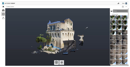
Figure 5.
3D model generated with ReCap Photo software.
5. Modelling in BIM
Through a backward path, we tried to reconstruct the initial morphology of the artifact and all the superfetations that happened over time: a kind of journey in the past that, starting from nowadays, has led us to the outset of the Tower in Marina di Vietri and its initial geometric configuration. When we encounter a historic good, the difficulty and—at the same time—the fascination of its modeling are elevated to the nth power: reviving, even in a digital world, the story of a building catapults the reader into a distant reality and no longer reachable. Although there was availability of historical material, there is an objective difficulty in developing the third dimension in a precise and meticulous manner due to the absence of metric data. In this case, vintage images and points in the space were the only elements available to investigate that unique building heritage.
Furthermore, if a “conventional” building can be demolished, for an architecture such as the one in question this circumstance is unthinkable, since it is a building of uncompromising historical value that will live forever.
In this sense, BIM is a valuable tool for the conservation of the building heritage representing at the same time a possible viewer of 3D objects/models and a data source/generator. Photos, documents, metadata and multimedia formats indispensable to better understand the subject of study and still, clouds of points, evolutionary geometric diagrams of the tower would feed the model of information belonging to the most disparate disciplines as a sort of media collector [5].
BIM is therefore the frontier, the watershed between the traditional methods of representation and documentation of goods and the innovative development processes of the models.
In the following dissertation we focused on the partition of the models into graphic and information parts. The graphic part is nothing but the volume of the Tower and its transposition from the level of representation to the three-dimensional space. This stage is a direct consequence of the surveys and the typology of the data (in our possession). On the other hand, the information aspects of the model—and their maintenance—actually make BIM the volumes previously implemented.
The fusion between graphics and computerization has generated the digital model of the event object of study.
If the data is easily implemented, this kind of architecture is rarely suitable/appropriate to modelling starting from standardized objects, precisely because each part and each element is the same as itself: unconventional and hardly parametrizable forms populate the 3D model of architecture object of the study [6].
The concept of digital object recalls, consequently, the concept of LODs that, in the Italian meaning of the term, it means: level of definition of the digital objects. They will be function of the phase target and of the model use. In particular, it would be better to distinguish between LOI and LOG, that is between Level of Information and Level of Geometry.
In the present case, we attempt to reproduce in the digital environment the geometry of the Tower during the ages, respecting—albeit conditioned by the lack of certain metric data—the quantitative and qualitative characteristics. In some cases, such structures have been simplified in objects that are still coherent.
Starting from what may be the original hypothesis given in Figure 1, three more evolutions of the model have been implemented (Figure 6).
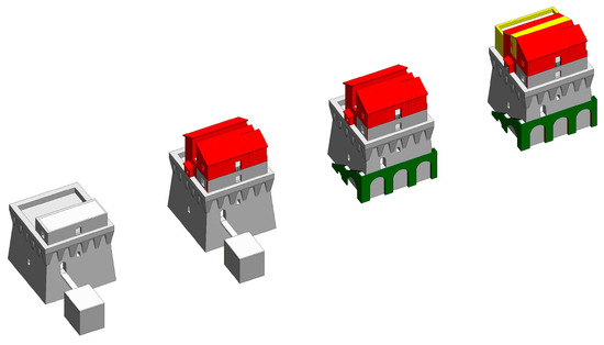
Figure 6.
Evolution of the geometry of the Tower from 1540 to today.
The first depicts the Tower at the beginning of 1800, when three bodies were added to the parade ground. These volumes were represented in red and portray the first addition to the starting model. Subsequently the addition of an entry at the bottom and the elimination of the battiponte have further modified the tower which assumed customs function. Finally, the realization of three more volumes and the covering of the parade ground, give us the tower as we see it today (Figure 7).
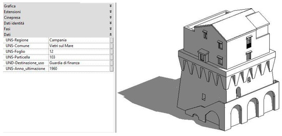
Figure 7.
BIM Model of the Tower representing its present state.
Even if, currently, there is a lack of a programmatic definition of the maintenance operations to be performed over time, the volumetric superfetations has been identified both graphically and semantically, the maintenance interventions realized over time, and a brief description of each part of the structure (Figure 8). Therefore, even if with readily achievable limitations, the result of the implementation in BIM of the Tower of Vietri sul Mare is attributable to a LOD F.
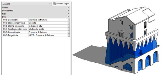
Figure 8.
Part of the semantic modelling implemented.
6. Conclusions
The appreciation of the historical-artistic heritage is essential for the defense and diffusion of our culture. Each architectural event brings with it a piece of history that, albeit not written, revives day after day in the places that guard it.
The use of the same, when not possible in the real world, becomes available in a virtual world through a journey through the time that leads the visitor to discover what has been. New visualization technologies destroy the distances between present and past, facilitating the understanding of the artifacts and their evolution over time. Survey and modeling techniques that have the purpose of documenting and telling the history through our architectures. The transmission of information acquired in the early stages of the research and the documentation would be more easily transferable through the realization of virtual models that facilitate the comprehension and are a link between the researcher and the less experienced user.
New forms of representation that would also allow us to pay attention not only on the well-established attractions in our territory but also on many others, enhancing the national artistic offer. If the purpose is to protect and enhance the architectural beauties of our land, we can widely consider the BIM as a vehicle of digital awareness capable to keep the geometry and semantics of the tower in an info-graphic model. The link between image and imagination—with the support of digital survey techniques—pulsates in the virtual “reconstruction” of the Tower, which, starting with the vintage images, has been gradually consolidated.
Acknowledgments
The research was possible thank the data information acquired by State archive of Salerno and the kindness obtained from sector Museums, Libraries and Pinacoteca of the Province of Salerno and the museum Royal Collection Trust of London from the images.
Author Contributions
D.B. and S.M. conceived and designed the research; S.M. analyzed the historical data and she took care of photogrammetry survey and post-processing phase with ReCap; D.B. designed BIM model with Revit, both wrote the paper.
Conflicts of Interest
The authors declare no conflict of interest.
References
- Russo, F. Le Torri Anticorsare Vicereali. Con Particolare Riferimento a Quelli Della Costa Campana; S.l., Istituto Italiano dei Castelli: Caserta, Italy, 2001. [Google Scholar]
- Talenti, S.; Morena, S. Da Positano a Sapri: La Rete di “Sguardi” del Sistema Difensivo Costiero. In Defensive Architecture of the Mediterranean XV to XVIII Centuries, Proceedings of the International Conference on Modern Age Fortifications of the Mediterranean Coast, Florence, Italy, 10–12 November 2016; Verdiani, G., Ed.; DIDApress: Firenze, Italy, 2016; pp. 169–176. ISBN 9788896080603. [Google Scholar]
- Santoro, L. Le Torri Costiere Della Provincia di Salerno: Paesaggio, Storia e Conservazione; Paparo Edizioni: Salerno, Italy, 2012; ISBN 9788897083498. [Google Scholar]
- Russo, F. Le Torri Costiere del Regno di Napoli, 2nd ed.; Edizioni scientifiche e Artistiche: Naples, Italy, 2009; ISBN 9788895430133. [Google Scholar]
- Barbato, D. Il BIM e l’AR: Strategie per la Gestione del Patrimonio Edilizio. In Carnevalis L. (by) Linee di Ricerca Nell’area del Disegno, 3rd ed.; Ermes. Servizi editoriali integrati srl: Ariccia, Italy, 2015; pp. 179–187. ISBN 97888-9750038. [Google Scholar]
- Barbato, D.; Morena, S. Infographic techniques for the representation of marginal buildings of Salerno coast. In Bertocci, S., Bini, M. (by) The Reasons of Drawing. Thought, Shape and Model in the Complexity Management, Proceedings of the XXXVIII Convegno Internazionale dei Docenti delle Discipline della Rappresentazione; Gangemi Editor: Rome, Italy, 2016; pp. 69–72. ISBN 978884923295. [Google Scholar]
Publisher’s Note: MDPI stays neutral with regard to jurisdictional claims in published maps and institutional affiliations. |
© 2017 by the authors. Licensee MDPI, Basel, Switzerland. This article is an open access article distributed under the terms and conditions of the Creative Commons Attribution (CC BY) license (http://creativecommons.org/licenses/by/4.0/).