Abstract
Paleogeomorphology exerts first-order control on the distribution of structural hydrocarbon reservoirs across regional unconformities, whereas variations in pore-throat architecture and flow capacity among different geomorphic units further govern hydrocarbon migration pathways and accumulation sites. Therefore, high-resolution reconstruction of regional paleogeomorphology is essential for effective exploration. This study investigates the Yanwu area of the Ordos Basin, where pre-Jurassic paleogeomorphology was reconstructed based on detailed stratigraphic analyses of the Yan’an Formation and the Yan-10 oil-bearing interval, and its influence on reservoir formation was systematically evaluated. Paleogeomorphology was delineated using well-log-based compensated impression methods integrated with localized 3D seismic inversion. Reservoir samples from distinct geomorphic units were analyzed through thin-section petrography, FESEM imaging, high-pressure mercury intrusion, and visualized micro-scale hydrocarbon charging experiments to characterize pore-throat systems and flow behavior. Four geomorphic units—paleohighs, slope zones, terraces, and valleys—were identified. Seismic inversion across the Yanwu tributary valley and the Honghe paleovalley confirms the reliability of the reconstructed geomorphology. Reservoirs within slope zones and terraces exhibit superior pore-throat structures, dominated by intergranular and dissolution pores, and display grid-like displacement patterns with higher ultimate recovery in micro-charging tests. Portions of the paleohighs show comparable reservoir quality and flow capacity. Results indicate that slope zones and terraces represent the most favorable hydrocarbon accumulation domains. Where overlying strata provide effective sealing, hydrocarbons preferentially accumulate on structural highs within these geomorphic units; in contrast, insufficient sealing transforms them into efficient migration conduits. Certain paleohighs may also host structural-high accumulations when capped by effective traps. The clarified accumulation patterns across geomorphic units offer a robust framework for guiding hydrocarbon exploration and reserve growth in regions with similar tectono-sedimentary settings.
1. Introduction
During geological evolution, the buried paleogeomorphologic features formed in different tectonic stages, characterized by distinct three-dimensional geometries, exert significant control on sedimentary infilling, diagenetic evolution, and hydrocarbon migration–accumulation processes [1,2,3]. As early as the mid-20th century, the international petroleum geology community had recognized the critical importance of paleogeomorphologic studies in hydrocarbon exploration [4,5]. Research practices conducted in typical hydrocarbon-bearing regions—such as western Canada, the intracontinental basins of central United States, North Africa, and West Siberia—have systematically elucidated the close relationship between paleogeomorphologic reconstruction and hydrocarbon field distribution, demonstrating that paleogeomorphologic configurations impose strong spatial constraints on hydrocarbon accumulation and enrichment [6,7,8,9,10].
Paleogeomorphologic research gradually emerged in the 1950s and has since been widely applied across multiple disciplines, including sedimentology, structural geology, reservoir geology, and petroleum geology. Driven by the petroleum industry, techniques and methods for paleogeomorphologic reconstruction have continuously evolved, with studies on pre-Jurassic paleogeomorphology in the Ordos Basin being among the most representative [11]. These studies have clarified the core objectives and approaches of paleogeomorphologic work: namely, reconstructing paleogeomorphologic forms, delineating geomorphic units, and analyzing their coupling relationships with stratigraphic superposition, sedimentary system distribution, structural evolution, and reservoir heterogeneity. Such analyses further elucidate the control mechanisms of paleogeomorphology on hydrocarbon migration and accumulation, and summarize the accumulation models and enrichment patterns of paleogeomorphology-related reservoirs, thereby enabling prediction of favorable accumulation zones and optimization of exploration strategies [12,13]. These efforts have not only deepened the understanding of hydrocarbon accumulation mechanisms but also significantly advanced petroleum geology theory and exploration technologies [14].
As a critical component of basin analysis and hydrocarbon exploration, paleoge-omorphologic reconstruction methods have undergone continuous development and refinement [15]. Currently, commonly used approaches include the residual thickness and compensated thickness impression method, back-stripping and infilling methods, sedimentology-based paleogeomorphologic reconstruction, and high-resolution sequence stratigraphy-based reconstruction [16]. Among these, the residual and compensated thickness impression method, based on the principle of “filling and compensation,” is simple, widely applicable, and remains the most commonly used approach. However, it is highly dependent on well density and spatial distribution, which may result in insufficient reconstruction accuracy and relatively large errors. Sedimentology-based reconstruction integrates various geological maps, paleogeologic background, and facies analyses to infer pre-depositional paleogeomorphic patterns from sedimentary processes and facies distributions, making it one of the more mature methods [17]. Although effective in capturing the overall paleogeomorphic outline, limitations remain in quantitative restoration of erosion thickness, compaction correction, and paleobathymetry reconstruction. High-resolution sequence stratigraphy-based reconstruction, using isochronous surfaces as reference planes rather than traditional stratigraphic tops, can more accurately reflect paleogeomorphic forms [18]. Nevertheless, its effectiveness depends on the precise establishment of reference surfaces, and the methodology has so far been applied only in limited regions, with the technical system still requiring further refinement [19].
Overall, current paleogeomorphologic reconstructions remain largely qualitative, with precision constrained by the completeness of sedimentary records and geological data. Improving reconstruction accuracy requires consideration of compaction, paleodepth, and erosion thickness, among other factors [20]. Recent advances in understanding basin sedimentary evolution have established sedimentologic analysis as a core pathway for paleogeomorphologic reconstruction. Furthermore, the widespread application of 2D and 3D seismic techniques has enabled a transition from traditional low-resolution, well-log-based qualitative reconstructions to high-resolution, multi-dimensional, integrated analyses. Accordingly, combining the impression method with 2D seismic profile validation, along with multi-source integration of well-log data and seismic facies analysis, represents a major future trend and development direction in hydrocarbon field paleogeomorphologic studies [21,22].
Paleogeomorphic configurations exert a fundamental control on the distribution and accumulation of hydrocarbon reservoirs. However, the pathways of hydrocarbon migration and the availability of effective storage space are ultimately dictated by the reservoir properties themselves, which serve as the primary medium for hydrocarbon transport and entrapment. High-quality reservoirs can function either as preferential sites for hydrocarbon accumulation or as efficient conduits during early hydrocarbon generation and migration. Consequently, a clear understanding of reservoir characteristics within different paleogeomorphic units is essential for elucidating the hydrocarbon accumulation patterns and overall petroleum system behavior of the study area. In the study of tight reservoirs, the characteristics of pore-throat structures and their control over reservoir flow capacity have long been central to reservoir evaluation and development geology [23,24,25]. Current methods for characterizing microporosity in tight reservoirs can be grouped into three main categories: 2D image observation, 3D volume reconstruction, and quantitative volumetric evaluation [26]. 2D image observation techniques, including optical microscopy and field-emission scanning electron microscopy (FESEM), allow qualitative or semi-quantitative description of pore morphology and distribution based on 2D images [27]. 3D reconstruction techniques, such as micro/nano CT scanning and focused ion beam-scanning electron microscopy (FIB-SEM), enable three-dimensional visualization of pore structure and connectivity. Quantitative volumetric evaluation methods—including low-temperature nitrogen adsorption, high-pressure mercury intrusion (HPMI), constant-rate mercury intrusion (CMI), and nuclear magnetic resonance (NMR)—allow quantification of porosity, pore size distribution, and connectivity within the reservoir space [28,29,30]. FESEM was employed to characterize nanoscale pore and grain morphologies through high-resolution imaging of rock microstructures. HPMI and CMI were used to quantify pore-throat architecture, with HPMI constraining fine pore-throat distributions and connectivity, and CMI reflecting the distribution of larger pore throats relevant to macroscopic flow behavior. NMR measurements provided non-destructive insights into pore structure and fluid occurrence by analyzing T2 relaxation time distributions, enabling discrimination between movable and bound fluids. Collectively, these approaches form the foundational framework for studying reservoir microstructures and provide essential tools for understanding property variations in tight reservoirs. However, most existing studies focus on static characterization of pore-throat structures, with limited attention to dynamic simulation and mechanistic analysis of fluid flow in low-permeability tight sandstone reservoirs [31]. Given the complex internal pore structures and strong heterogeneity of these reservoirs, conventional experimental methods alone are insufficient to fully reveal fluid migration processes and controlling factors within micropore-throat systems [32]. Therefore, there is an urgent need to introduce novel methods capable of visually simulating fluid migration under complex geological conditions, combined with multi-scale analyses of micro-pore-throat structures, to achieve in-depth understanding and quantitative evaluation of tight reservoir flow mechanisms [33].
In recent years, ongoing exploration and development in the Yanwu area of the Ordos Basin have led to a series of significant new discoveries within the Jurassic petroleum system. The Fuxian Formation and the Yan-10 oil-bearing interval, in particular, have emerged as key source and reservoir targets and have been the focus of intensive development. Previous studies have demonstrated that hydrocarbon distribution in the Yanwu area is strongly controlled by paleogeomorphic patterns, with accumulations traditionally concentrated along paleoslope zones. However, recent exploration results reveal hydrocarbon shows on elevated paleohighs—locations previously considered unfavorable. Meanwhile, newly acquired drilling data and 3D seismic volumes indicate that paleogeomorphic configurations in several parts of the area differ markedly from earlier interpretations.
These shifts underscore the urgent need for high-resolution paleogeomorphic reconstruction to clarify the relationship between newly discovered reservoirs and underlying geomorphic features. Moreover, a detailed investigation of reservoir pore-throat architecture and flow capacity is essential for refining the hydrocarbon accumulation model of the area. Together, these efforts will provide a more robust geological basis and technical support for guiding future exploration strategies and development planning in the Yanwu region [34,35,36].
In this study, a detailed reconstruction and characterization of the pre-Jurassic paleogeomorphology of the Yanwu area was achieved by integrating compensation imprinting techniques with 3D seismic and well log data. By selecting representative paleogeomorphic units, core samples from corresponding well locations were pre-processed, followed by comprehensive analyses using cast thin sections, scanning electron microscopy (SEM), and visual micro-oil and gas injection experiments. Based on these analyses, a comparative study was conducted on the reservoir petrology, pore-throat structures, and flow characteristics of the different paleogeomorphic units. This approach allowed for an in-depth exploration of how the variations in paleogeomorphic units influence the hydrocarbon accumulation patterns within the Yan’an Formation, ultimately leading to a discussion of the reservoir accumulation models for the study area.
2. Geological Background
The Yanwu area is located on the southwestern margin of the Ordos Basin, a multi-cyclic superimposed basin developed on the stable Paleozoic North China Craton. As China’s second-largest sedimentary basin, the Ordos Basin has experienced three major tectonic events since the Mesozoic: the Indosinian, Yanshanian, and Himalayan orogenies. Structurally, the basin can be divided into six primary tectonic units: the western marginal thrust zone, Yimeng Uplift, Tianhuan Depression, Yi-Shan Slope, western Jinxi Flexural Belt, and Weibei Uplift (Figure 1a). During the Late Triassic to Early Jurassic, the basin evolved progressively inland under the influence of Indosinian tectonism. The Yan’an Formation records this evolution, with deposition, contraction, and eventual disappearance of the lake basin resulting in the accumulation of substantial clastic sediments. Notably, the Chang 7 Member of the Yan’an Formation represents the peak stage of lake development [37].
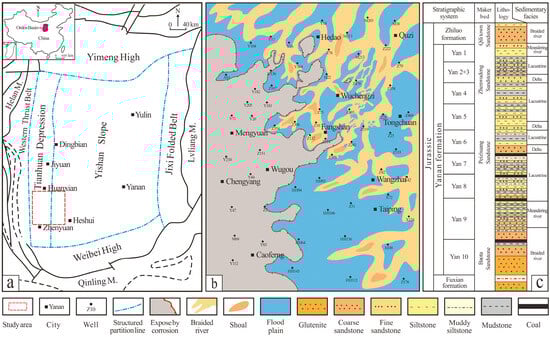
Figure 1.
Comprehensive study map of the Yanwu area, Ordos Basin: (a) location map of the study area; (b) Plane distribution map of sedimentary microfacies of the Yan 10 oil layer group in the Yanwu area; (c) Stratigraphic division of the Yanan & Fuxian formation in the Dingbian area.
The Yanwu area is characterized by complex geological conditions due to its proximity to the Tianhuan Depression and control by local anticlinal structures. In this region, the Jurassic Yan’an Formation consists of interbedded dark gray mudstones and gray sandstones, locally intercalated with multiple coal seams that serve as reliable marker horizons (Figure 1c). Based on these marker beds, the Yan’an Formation can be subdivided from the bottom up into ten oil-bearing units (Yan 1–Yan 10), whereas the underlying Fuxian Formation maintains a parallel and conformable contact with the Yan’an Formation. Tectonic activity, including episodic uplift, erosion, and incision by Jurassic paleo-rivers, has led to extensive westward loss of the Yan 10 and Fuxian oil-bearing units, confining their development to the eastern and northeastern parts of the study area (Figure 1b). Therefore, this study focuses on the Yan 10 and Fuxian oil-bearing units in the Yanwu area, which are critical for understanding regional hydrocarbon accumulation [38].
3. Samples and Methods
3.1. Samples
This study aims to reconstruct and precisely characterize the pre-Jurassic paleogeomorphology of the Yanwu area and to investigate the reservoir petrography, pore-throat structures, and flow properties of different geomorphic units. The objective is to elucidate the hydrocarbon accumulation patterns and the primary controlling factors under paleogeomorphological structural influences. For the oil–source comparison, crude oil samples from the Chang 9 interval in both the northwest and northeast source areas of Dingbian, as well as source rock samples from the Chang 7 and Chang 9 intervals, were selected for laboratory analysis (Table 1).

Table 1.
Partial Results of Paleogeomorphology Restoration.
Sample selection was tailored to the specific research objectives and the available data. For a detailed paleogeomorphological reconstruction, well log data from 636 preliminary exploration wells within the study area were utilized, supplemented by limited 2D seismic data.
For analyses of reservoir petrography, pore-throat architecture, and flow behavior, an initial field survey was conducted on core samples from 122 exploration wells. From this, cores from 40 wells were selected to achieve comprehensive spatial coverage. These samples were then categorized and prepared according to the specific requirements of subsequent analyses.
3.2. Methods
To achieve a detailed reconstruction of the pre-Jurassic paleogeomorphology in the study area, this study adopted the compensation imprint method [39], selected based on a synthesis of mainstream approaches and the availability of existing data. This method is advantageous as it integrates paleotectonic restoration with stratigraphic thickness corrections, thereby accounting for the effects of tectonic evolution and differential reservoir development on paleogeomorphic patterns. The method conceptualizes the paleosurface to be restored as a landform at the cessation of erosion and the onset of overlying sedimentation. It leverages the “mirror” relationship between residual paleosurfaces and their overlying strata and employs the thickness of the overlying layers for semi-quantitative restoration of paleogeomorphic features. When the spatial distribution of exploration wells is sufficiently dense, this approach can achieve high reconstruction accuracy (Figure 2).
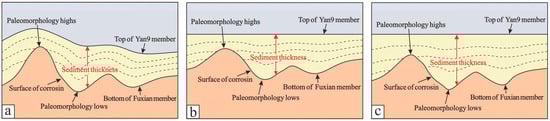
Figure 2.
Schematic diagram illustrating the principle of paleogeomorphologic restoration using the compensation method: (a) Present burial condition; (b) Flatten the top of the sign layer; (c) De-compaction correction.
Based on the above considerations, the first step involves establishing an appropriate reference datum. In the Ordos Basin, the Triassic Yan’an Formation Member 9 (Yan-9) exhibits a regionally stable distribution, and its upper boundary is marked by a distinctive 4–6 m coal seam. This coal layer is readily identifiable on well logs by its characteristic low density, low gamma-ray values, high resistivity, and high acoustic transit time. Accordingly, the top of the Yan-9 interval was selected as the reference datum for paleogeomorphic reconstruction. Compaction correction was then applied to restore the original depositional thickness between the base of the Fuxian Formation and the top of the Yan-9 interval, from which the pre-Jurassic paleogeomorphic surface was reconstructed. Previous studies have shown that rock porosity decreases exponentially with burial depth, indicating a quantifiable relationship between porosity and depth [40,41,42]. This relationship can be expressed as:
where is the burial depth of the stratum; is the rock porosity at depth ; is the original porosity at the surface, and is the compaction coefficient.
By applying Equation (1), porosity data from strata at different burial depths can be used to fit the corresponding relationship curve, from which the surface original porosity and the compaction coefficient () can be determined. Due to the influence of lithology, it is necessary to derive separate surface original porosity and compaction coefficients for sandstones and mudstones within the study area. During burial, strata undergo compaction in response to the increasing overburden stress. Assuming the present-day top and base of a formation are located at depths h1 and h2, respectively, with a porosity of φ, the current formation thickness is Δh = h2 − h1. The compacted (solid-grain) thickness (h_g) can then be calculated using the depth-dependent porosity function φ(h):
Under the assumption of grain-volume conservation, the solid-grain thickness (hg) is considered independent of burial depth, such that:
Based on the porosity–depth function established for the formation, both the original (uncompacted) thickness and the thickness at any burial depth can be quantitatively reconstructed.
For the study of reservoir pore structure characteristics, core samples were collected during field observations in the study area. Thin sections prepared at the Low-Permeability Laboratory of PetroChina Changqing Oilfield were examined under a polarizing microscope to identify mineral types and cement compositions. Quantitative analysis was conducted using ImageJ software (version 2.1.4.6) by calibrating target minerals and cements under the microscope. Additionally, cathodoluminescence (CL) experiments were performed to observe the cementation patterns of different clay minerals at the microscopic scale.
The study of reservoir pore-throat structures also employed targeted core sampling. Selected cores were prepared as thin sections for observation under a polarizing microscope to examine micro-porosity and pore structure characteristics. Based on these observations, representative samples were further prepared for high-resolution field emission scanning electron microscopy (FESEM) to investigate the three-dimensional pore structures and features of reservoirs under the control of different paleogeomorphic units.
Based on microscopic observations, core samples from the same wells and depths as the thin sections were selected and cut into cylindrical plugs with a diameter of 2.5 cm and a length of 3.5 cm. The plugs were solvent-extracted to remove residual hydrocarbons and then dried in a 100 °C oven for 48 h. Mercury intrusion porosimetry (Autopore IV 9500, Micromeritics Instrument Corporation, located in Norcross, GA, USA) was conducted over a pressure range of 0.1–60,000 psi to measure mercury saturation and to acquire capillary pressure, saturation, and pore-throat parameters, including displacement pressure and maximum mercury saturation. These data were used to comprehensively analyze reservoir pore-throat characteristics under the control of different paleogeomorphic units.
Extensive core samples from representative wells in the study area were collected and measured for porosity and permeability at the Low-Permeability Laboratory of PetroChina Changqing Oilfield. Physical property data from cores corresponding to different paleogeomorphic units reconstructed through paleogeomorphology were statistically analyzed. Porosity–permeability crossplots were generated to characterize the reservoir properties under varying geomorphic controls.
Reservoir flow capacity and characteristics were further investigated using microscale waterflood experiments based on a patented real sandstone model developed by the Department of Geology, Northwest University. This approach allows direct visualization of microscopic flow paths and residual oil distribution in reservoirs under the control of different paleogeomorphic units.
The microscale flow visualization system consists of six components: an air compressor, pressure regulator, metering capillary, real sandstone model, microscope, and image processing system (Figure 3). Core samples corresponding to wells from different paleogeomorphic units in the study area were first solvent-extracted to remove residual hydrocarbons and then oven-dried at 100 °C for 48 h. The dried samples were subsequently fabricated into models measuring 3.5 cm in length, 2.5 cm in width, and 0.8 mm in thickness. These models can withstand pressures of 0.2–0.3 MPa, a maximum temperature of 200 °C, and up to 100 °C under pressurized conditions.
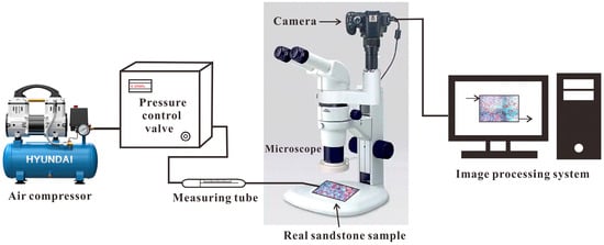
Figure 3.
Schematic diagram illustrating the principle of the visual hydrocarbon migration and accumulation simulation experiment.
For the visualization experiments, simulated formation water with a salinity comparable to that of the Yan 10 Member and Fuxian Formation was prepared. The experimental oil was a mixture of kerosene and mechanical pump oil, blended in a fixed ratio to achieve a viscosity of approximately 3.3 mPa·s. Methylene blue and oil-soluble red dyes were added to the simulated formation water and oil, respectively, to differentiate the fluids visually during the displacement process.
Natural sandstone models were prepared together with simulated formation water and oil. Prior to experimentation, the sealing integrity of each model was verified, ensuring that all potential leakage points, except for the inlet and outlet, were properly sealed. The dimensions of each model were measured. Each model was evacuated under vacuum and subsequently saturated with simulated formation water. The pore volume of each model was determined inversely based on the volume of water required for full saturation, which was used to calculate porosity. Water permeability under saturated conditions was measured repeatedly, and the mean value was recorded. Microscopic observations of the water-saturated models were conducted under both full-field and localized views using a Nikon SMZ1000 (Manufactured by Nikon Corporation, Tokyo, Japan) stereomicroscope, and images were captured to estimate water saturation. The models were then saturated with simulated oil until only oil was observed at the outlet, and full-field and localized microscopic images were acquired to estimate the initial oil saturation. Waterflooding experiments were performed by applying a small initial driving pressure. When the no-water-production stage was reached, full-field and localized microscopic images were recorded, and oil recovery efficiency at this stage was quantified. The displacement pressure was subsequently increased stepwise until the completion of the experiment. Continuous microscopic imaging throughout the procedure allowed the quantification of oil recovery efficiency and residual oil distribution for samples corresponding to different paleogeomorphic units.
4. Results
4.1. Classification of Paleogeomorphic Units and Results of Pre-Jurassic Paleogeographic Restoration
Porosity data obtained from formations at various burial depths were used to fit the φ–h relationship through Equation (1), from which the surface porosity φ0 and the compaction coefficient C were derived (Figure 4). The sandstone porosity–depth relationship is expressed as φ = 44.187 × 10−0.000835H, allowing the original thickness of sandstones between the Fuxian base (or Yan 10 base) and the top of the Yan 9 Member to be reconstructed. In addition, according to the empirical relationship used by Changqing Oilfield, the mudstone φ–h function for the study area is given by φ = 0.67e−0.000945H. Based on the assumption of grain-volume conservation, the corresponding original mudstone thickness can also be restored. Finally, the total restored thickness is obtained by combining the reconstructed sandstone and mudstone thicknesses, enabling the recovery of the pre-Jurassic palaeogeomorphic morphology of the study area.
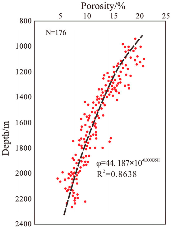
Figure 4.
Depth–porosity (h–φ) relationship for sandstone.
Well logging data from 636 wells in the Yanwu area were systematically analyzed and compiled. Sandstone and mudstone intervals from wells across different subareas were corrected for compaction using computational programming. Based on these corrections, the original depositional thicknesses from the base of the Fuxian Formation to the top of the Yan-9 member, as well as the measured formation compaction ratios, were quantitatively restored for all wells within the study area (Table 1).
Based on the delineation of paleogeomorphic unit boundaries using sedimentological and well-log data, a pre-Jurassic paleogeographic map of the Yanwu area was generated through the combined application of the 3D geological mapping software Geomap (version 3.0) and the drawing software CorelDRAW (version 17.1) (Figure 5). In selected areas, two-dimensional seismic data were used for detailed verification and comparative interpretation, further ensuring the accuracy and reliability of the paleogeographic reconstruction. The pre-Jurassic paleogeography of the Yanwu area was subdivided into four geomorphic units: paleo-highs, slope belts, paleo-terraces, and paleo-valleys.
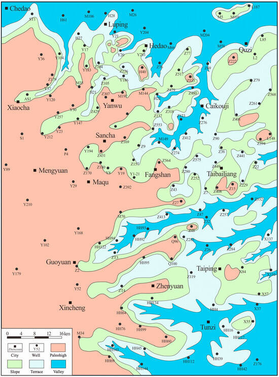
Figure 5.
Planar distribution map of pre-Jurassic paleogeomorphology in the Yanwu area.
Paleohigh—These are mainly distributed in the western part of the study area, with sporadic occurrences in the east, and represent the highest topographic elevations among the reconstructed paleogeomorphic units. The overall slope of this unit is relatively gentle. The formation of the paleo-highs is attributed to extensive erosion during the deposition of the Fuxian Formation and Yan-10 oil-bearing member, with little or no subsequent sediment accumulation, resulting in present-day features characterized by missing strata of the Fuxian Formation and Yan-10 member.
Slope—Slopes constitute the primary transitional zones between the paleo-highs and paleo-valleys. Adjacent to the highs, these belts exhibit relatively steep slopes and are mainly distributed in the central-northern and northeastern parts of the study area, such as the Taibai Liang region. Slope belt areas were the main depositional sites for early fine-grained sediments, which are well-sorted, moderately rounded, and evenly distributed, making them key zones for hydrocarbon accumulation.
Terraces—Terraces form secondary transitional zones between the paleo-highs and paleo-valleys, located closer to the valleys. The slope gradient of this unit is intermediate between that of the highs and the slope belts, and the internal sediments are finer than those of the slope belts. This geomorphic unit is mainly distributed in the central-eastern part of the study area.
Valley—Five Valleys trending from east to west were identified in the study area, representing the lowest topographic elevations among the reconstructed units. The Yan’an Formation within these valleys is relatively well preserved, retaining a more complete depositional system while the contemporaneous paleo-highs were undergoing erosion. However, strong subaerial incision in the valleys often resulted in the Yan-10 member and Fuxian Formation being in unconformable contact with the underlying Chang-2 and Chang-3 oil-bearing members.
Building on the restoration of pre-Jurassic paleogeography using the compensatory mold method, two-dimensional seismic profiles provided by the PetroChina Eastern Geophysical Company were employed in combination with well-log data to perform secondary verification of local areas, such as the paleo-valleys in the Honghe region and the Yanwu northern branch valleys (Figure 6 and Figure 7). The results indicate that the paleogeomorphic features reconstructed by the mold method exhibit high accuracy and are consistent with the topographic characteristics inferred from the 2D seismic profiles, thereby enhancing the reliability of the paleogeographic reconstruction.
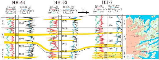
Figure 6.
Well-log validation cross-section of paleo-valleys in the Honghe area.
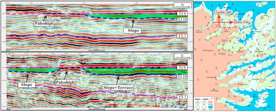
Figure 7.
3D seismic profile validation of tributary valleys in the northern Yanwu area.
4.2. Reservoir Petrographic Characteristics
Following a detailed reconstruction of paleogeomorphic features in the Yanwu area, the petrographic characteristics of a total of 75 sandstone thin sections from 40 sampled wells were classified and statistically analyzed according to the delineated paleogeomorphic units.
Comparison of petrographic features among different paleogeomorphic units indicates that the paleo-high units are dominated by lithic-feldspathic sandstones, whereas the slope belt units are primarily composed of feldspathic-lithic sandstones. The petrographic composition of the paleo-terrace and paleo-valley units falls between those of the paleo-highs and slope belts (Figure 8).
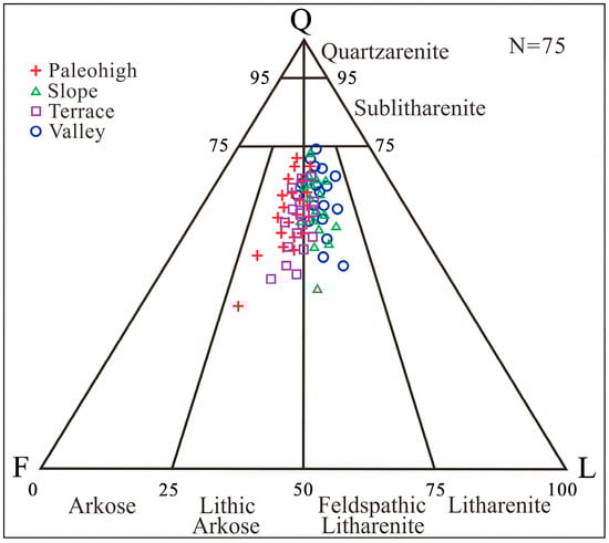
Figure 8.
Ternary lithology diagram of different paleogeomorphic units of the Fuxian Formation and Yan 10 oil layer group in the Yanwu area.
Analysis of the sandstone grain-size distribution (Figure 9a) and grain sorting characteristics (Figure 9b) across different paleogeomorphic units in the Yanwu area indicates that the sediments are predominantly fine- to medium-grained sandstones, with generally good sorting. In the slope belt paleogeomorphic units, fine-grained sandstones dominate, followed by medium-grained sands, and clastic grains exhibit good sorting. Similarly, the paleo-terrace units are characterized by fine-grained sandstones with relatively well-sorted clastic grains. In contrast, sediments from the paleo-high units display relatively poorer sorting of clastic grains, while clastic grains in the paleo-valley units tend to be finer in size.
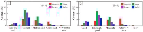
Figure 9.
Statistical diagram of petrographic characteristics of different paleogeomorphic units of the Fuxian Formation and Yan 10 oil layer group in the Yanwu area: (a) Grain-size distribution diagram of sandstone; (b) Sorting degree distribution map of sedimentary particles.
4.3. Pore-Throat Structure and Reservoir Properties
The primary pore types in the Fuxian Formation and Yan-10 oil-bearing member of the Yanwu area are intergranular pores, feldspar dissolution pores, lithic fragment dissolution pores, and intercrystalline pores, with minor occurrences of intergranular dissolution pores and microfractures. Classification and statistical analysis of these pore types were conducted for different paleogeomorphic units (Figure 10).
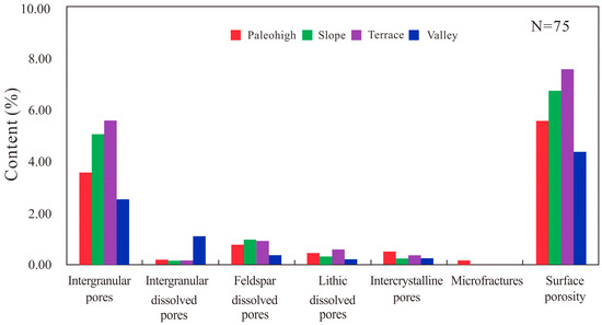
Figure 10.
Statistical diagram of pore types in different paleogeomorphic units of the Fuxian Formation and Yan 10 oil layer group in the Yanwu area.
The total porosity of the paleo-high units is 5.56%, with intergranular pores as the dominant pore type, accounting for 3.55%, followed by feldspar dissolution pores (0.76%), intercrystalline pores (0.48%), lithic fragment dissolution pores (0.43%), intergranular dissolution pores (0.18%), and microfractures (0.16%). Intergranular dissolution pores can also be observed under polarized light microscopy (Figure 11a), while high-resolution field emission scanning electron microscopy (FESEM) reveals partial intergranular pores cemented or filled by chlorite (Figure 11h,i).
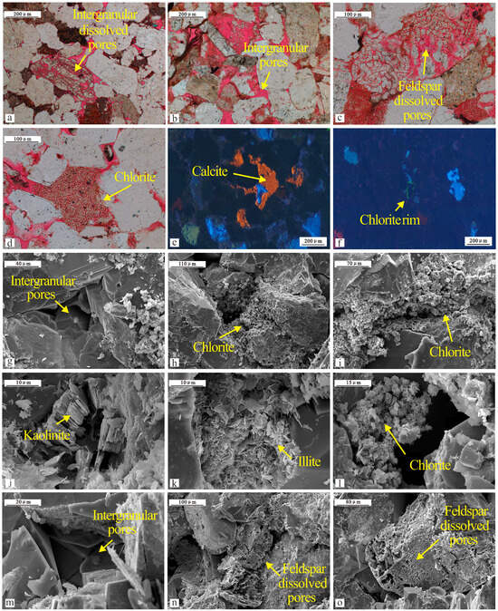
Figure 11.
Pore-throat structure characteristics and pore-filling material types of the Fuxian Formation and Yan 10 member reservoirs in the Yanwu area (Fuxian Formation = FX, Yan10 member = Y10): (a) Well Y116, 1857.5 m, FX, intragranular dissolution pores and intergranular pores; (b) Well Z277, 2143.8 m, FX, intergranular pores and feldspar dissolution pores; (c) Well Z243, 1962.2 m, Y10, feldspar dissolution pores filled with kaolinite; (d) Well Z516, 1994.8 m, Y10, intergranular pores filled with chlorite; (e) Well Z287, 2179.3 m, FX, intergranular pores filled with calcite observed under cathodoluminescence; (f) Well Z413, 2015.7 m, Y10, quartz grains coated by chlorite films observed under cathodoluminescence; (g) Well Z250, 2138.5 m, FX, intergranular pores observed under scanning electron microscope (FESEM); (h) Well Z27, 1952.8 m, Y10, intergranular pores cemented and filled by chlorite; (i) Well L148, 2154.3 m, FX, intergranular pores cemented and filled by chlorite; (j) Well M144, 1959.1 m, Y10, intergranular pores filled with kaolinite; (k) Well Z332, 1829.1 m, Y10, intergranular pores filled with illite; (l) Well Z90, 2148.7 m, FX, intergranular pores partially filled with chlorite; (m) Well Z441, 2065.8 m, FX, well-developed intergranular pores with chlorite films coating the surfaces of quartz grains; (n) Well Z517, 2169.2 m, FX, feldspar grains dissolved to form feldspar dissolution pores; (o) Well L85, 1993.6 m, Y10, feldspar grains partially dissolved to form secondary dissolution pores.
For the slope belt units, the total porosity is 6.75%, with intergranular pores again as the main pore type (5.07%), followed by feldspar dissolution pores (0.97%), lithic fragment dissolution pores (0.31%), and intercrystalline pores (0.23%), whereas intergranular dissolution pores (0.14%) and microfractures (0.03%) are sparsely developed. Under polarized light microscopy, intergranular pores are well developed (Figure 11b). Cathodoluminescence observations reveal quartz grains coated by chlorite films (Figure 11f), and SEM observations confirm the presence of well-developed intergranular pores (Figure 11g) and feldspar dissolution pores (Figure 11n,o).
The paleo-terrace units have a total porosity of 7.61%, with intergranular pores dominating (5.58%), followed by feldspar dissolution pores (0.92%), lithic fragment dissolution pores (0.58%), intercrystalline pores (0.35%), and minor intergranular dissolution pores (0.15%) and microfractures (0.03%). Polarized light microscopy reveals feldspar dissolution pores and secondary pores filled with kaolinite (Figure 11c). Cathodoluminescence shows calcite-cemented pores (Figure 11e), and FESEM imaging identifies kaolinite and illite filling pore spaces (Figure 11j,k).
The paleo-valley units exhibit a total porosity of 4.39%, with intergranular pores as the main pore type (2.53%), followed by intergranular dissolution pores (1.09%), feldspar dissolution pores (0.35%), intercrystalline pores (0.24%), and lithic fragment dissolution pores (0.19%). Microfractures were not observed in the thin-section samples. Polarized light microscopy shows chlorite-filled intergranular pores (Figure 11d), while FESEM observations reveal kaolinite- and illite-filled pores (Figure 11l) and chlorite films coating quartz grain cement (Figure 11m).
Capillary pressure data obtained from high-pressure mercury injection experiments on the Fuxian Formation and Yan-10 oil-bearing member in the Yanwu area were statistically analyzed and classified according to different paleogeomorphic units (Table 2). The results indicate that the average displacement pressure of the reservoirs ranges from 0.18 to 0.39 MPa, the mean median pressure ranges from 1.05 to 3.38 MPa, the mean median pore-throat radius ranges from 0.45 to 0.85 μm, the maximum mercury saturation (SHg) ranges from 72.89% to 88.63%, and the mercury withdrawal efficiency ranges from 20.19% to 27.55%. The MICP (mercury intrusion capillary pressure) experiment injects the non-wetting phase mercury into rock pores under progressively increasing external pressure, and quantitatively characterizes reservoir pore-throat structure based on the relationship between pressure and pore-throat radius. Based on these statistics and the distribution of capillary pressure across different paleogeomorphic units, it is evident that the slope belt and paleo-terrace units exhibit relatively well-developed pore-throat structures, whereas the paleo-high and paleo-valley units show overall poorer pore-throat distribution and parameters (Figure 12). Overall, the reservoirs in the study area are characterized as fine-pore-throat types with low displacement pressures and small median radii.
Table 2.
Evaluation of reservoir pore-throat structure in different paleogeomorphic units of the Fuxian Formation and Yan 10 oil layer group in the Yanwu area.
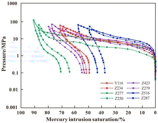
Figure 12.
Comparison of mercury injection capillary pressure (MICP) curves of reservoirs in different paleogeomorphic units of the Fuxian Formation and Yan 10 oil layer group in the Yanwu area.
A statistical analysis of reservoir properties was conducted for different paleogeomorphic units. For the paleo-high units, measurements from 30 core samples indicate porosity values ranging from 7% to 13%, with an average of 9.8%, and permeability ranging from 0.25 to 10.55 mD, with a mean of 5.28 mD. In the slope belt units, 50 core samples show porosity ranging from 14% to 22%, with an average of 17.9%, and permeability ranging from 8.51 to 130.29 mD, with an average of 88.25 mD. The paleo-terrace units, based on 40 core samples, exhibit porosity between 9% and 16%, averaging 10.2%, and permeability between 1.05 and 62.25 mD, with a mean of 12.03 mD. For the paleo-valley units, 20 core samples indicate porosity values from 5% to 11%, averaging 6.8%, and permeability ranging from 0.15 to 5.88 mD, with a mean of 2.25 mD (Table 3). Cross-plots of porosity versus permeability for the different paleogeomorphic units further indicate that the slope belt and paleo-terrace units possess relatively better reservoir properties. Overall, the reservoirs in the study area can be classified as low-porosity, low- to moderate-permeability types (Figure 13).
Table 3.
Evaluation of reservoir pore-throat structure in different paleogeomorphic units of the Fuxian Formation and Yan 10 oil layer group in the Yanwu area.
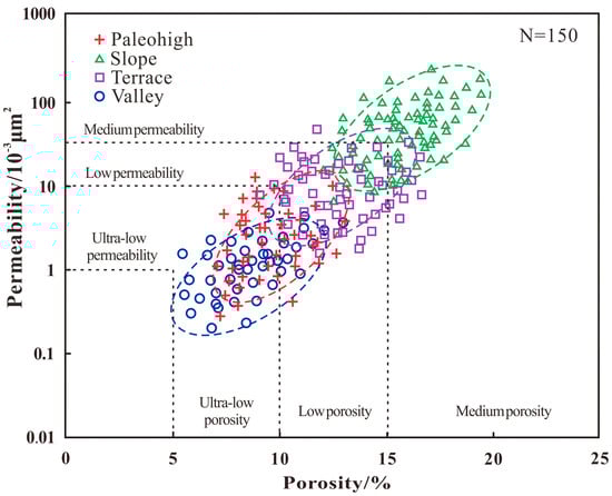
Figure 13.
Porosity–permeability cross-plot of reservoirs in different paleogeomorphic units of the Fuxian Formation and Yan 10 oil layer group in the Yanwu area.
4.4. Reservoir Flow Characteristics
A statistical analysis was conducted on the results of microscopic visualized reservoir displacement experiments performed on 10 core samples from the Yan’an Formation and Yan-10 oil-bearing member in the Yanwu area. The experiments simulated the hydrocarbon charging process under early depositional conditions to investigate the correspondence between different pore-throat structures and hydrocarbon accumulation characteristics. Based on continuous microscopic observations during the simulated charging process, three types of hydrocarbon displacement patterns were identified: grid-like displacement, stripe-like displacement, and finger-like displacement (Figure 14).

Figure 14.
Results of visual stratigraphic charging simulation experiments for the Fuxian Formation and Yan 10 oil layer group in the Yanwu area (Fuxian Formation = FX, Yan10 member = Y10): (a) Well Z277, 2143.8 m, FX, hydrocarbons charge along a grid-like pattern; (b) Well Z243, 1962.2 m, Y10, hydrocarbons charge along a grid-like pattern; (c) Well Z90, 2148.7 m, FX, hydrocarbons charge along a banded-like pattern; (d) Well M144, 1959.1 m, Y10, hydrocarbons charge along a finger-like pattern.
Based on a comprehensive comparative analysis of porosity, permeability, primary and final displacement pathways, and oil recovery efficiency obtained from the simulated displacement experiments, the reservoir pore-throat structures and flow capacities were classified into three categories (Table 4). For Type I reservoirs, the average oil recovery efficiency at the no-water-production stage is 30.7%, and at the final stage is 50.2%; this type is mainly associated with the slope belt paleogeomorphic units. Type II reservoirs exhibit average oil recovery efficiencies of 22.5% at the no-water-production stage and 37.5% at the final stage, corresponding primarily to paleo-terrace units. Type III reservoirs show average oil recovery efficiencies of 15.1% at the no-water-production stage and 29.9% at the final stage, predominantly corresponding to paleo-valley units. The experimental results indicate that slope belt units, with better-developed pore-throat structures and higher flow capacities, are more favorable for early hydrocarbon migration and accumulation in the reservoirs (Figure 15).
Table 4.
Evaluation of reservoir pore-throat structure in different paleogeomorphic units of the Fuxian Formation and Yan 10 oil layer group in the Yanwu area.
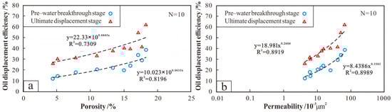
Figure 15.
Relationship between reservoir properties and oil recovery efficiency of the Fuxian Formation and Yan 10 oil layer group in the Yanwu area: (a) Porosity vs. oil recovery efficiency plot; (b) Permeability vs. oil recovery efficiency plot.
5. Discussion
5.1. Influence of Paleogeomorphology on Sedimentary Facies and Reservoir Lithofacies
The formation and evolution of the pre-Jurassic paleogeomorphology in the Yanwu area was a prolonged and complex process. Influenced by the Indosinian Orogeny, the Ordos Basin underwent a general uplift during the Early Jurassic, with pronounced local uplifts. Fluvial incision gradually intensified under the combined effects of tectonic movements [43]. Located in the southwestern Ordos Basin, the study area experienced the development of a paleo-land during this uplift. Differential weathering and fluvial erosion in this paleolandscape resulted in widespread unconformable contacts between the Yanchang Formation and the Fuxian and Yan-10 reservoir strata, generating typical river–terrace paleogeomorphology, including paleohighs, slopes, paleo-terraces, and ancient valleys.
As Early Jurassic strata, the Fuxian Formation and Yan-10 reservoirs were deposited to compensate for and infill the negative paleotopography. Therefore, the spatial distribution of sedimentary microfacies was strongly controlled by the underlying paleogeomorphology (Figure 1b and Figure 4). Specifically, paleohighs corresponded to eroded zones in the microfacies maps; slopes and paleo-terraces corresponded to floodplains and parts of braided river channels; while ancient valleys accommodated later braided river channels and localized shoal development.
The differing formation and evolution processes of these paleogeomorphic units also resulted in distinct reservoir lithofacies characteristics. Paleohigh units, representing proximal-source areas, were subjected to intense erosion. Their sediments were relatively coarse-grained, with higher quartz and lithic contents, dominated by lithic-feldspathic sandstones, poorly sorted, and with low roundness—typical of proximal-source depositional systems. Slope and paleo-terrace units, acting as key sediment transport pathways, experienced moderate-to-high depositional energy and stable sediment supply, producing well-sorted medium- to fine-grained sandstones. Ancient valley units, representing low-lying depressions, served as sediment accumulation zones and were influenced by aqueous depositional environments, developing a characteristic bimodal sedimentary structure: coarse sandstones at the base transitioning upward to medium- to fine-grained sandstones and siltstones. Overall, sediments in these depressions were finer-grained and well sorted.
5.2. Effect of Geomorphic Unit Pore-Throat Types on Reservoir Permeability
Pore-throat structure is the fundamental factor controlling reservoir flow capacity, and its development is influenced by multiple factors, including sedimentary facies, diagenetic evolution, and paleogeomorphic background. Variations in depositional energy, sediment supply, early mechanical compaction, and subsequent dissolution during diagenesis among different paleogeomorphic units lead to distinct pore-throat assemblages, resulting in significant differences in reservoir permeability [44,45,46].
In the Yanwu area, paleogeomorphic variation not only determined the initial pore types and connectivity but also influenced secondary pore development—such as dissolution pores, intergranular pores, and microfractures—by controlling the degree of compaction and diagenetic fluid activity. Therefore, differences in pore-throat structures among paleohighs, slopes, paleo-terraces, and ancient valleys are directly reflected in variations in reservoir flow capacity.
Paleohigh units are dominated by intergranular and feldspar dissolution pores and exhibit relatively high displacement pressures (0.35 MPa). Consequently, simulated injection experiments in these units primarily show channelized (strip-like) displacement. However, in areas such as well Y116, where secondary dissolution and primary intergranular pores are well developed, the pore-throat structure is improved, with permeability reaching 24.95 mD. In these cases, displacement occurs in a combined grid–channel pattern, and the final oil recovery efficiency reaches 40.8%.
Slope and terrace units, as major sediment transport pathways, are dominated by intergranular and secondary dissolution pores (feldspar + lithic dissolution pores), characterized by lower displacement pressures and larger median pore-throat radii. Their pore-throat assemblages are therefore more favorable, which is reflected in superior average petrophysical properties compared to paleohighs and ancient valleys. Simulated injection experiments in representative wells such as Z277, Z250, and Z423 primarily exhibit grid-like displacement, achieving an average final oil recovery efficiency of 53.4%, indicating good reservoir flow capacity.
Ancient valley units experienced highly variable depositional energy, resulting in strongly heterogeneous pore-throat structures, often exhibiting complex coexisting types such as “coarse-pores–fine-throats” and “fine-pores–fine-throats.” Consequently, reservoirs in these units are highly heterogeneous, with coexisting high- and low-permeability zones. This is consistent with simulated injection results from wells Z516 and Z287, where displacement is dominated by finger-like patterns and final oil recovery reaches only 28.8%, reflecting relatively poor reservoir flow capacity.
5.3. Paleogeomorphology-Controlled Reservoir Accumulation Patterns: Classification of Different Geomorphic Units
Through detailed characterization of paleogeomorphology in the Yanwu area and integrated analysis of pore-throat structures and flow capacities of different geomorphic units, it is evident that reservoir properties vary significantly among units. As reservoirs serve either as major pathways for hydrocarbon migration or as final accumulation sites, different reservoir types correspond to distinct hydrocarbon accumulation patterns. Accordingly, combining structural configuration, distribution of depositional sand bodies, pore-throat characteristics, and flow capacities of the various paleogeomorphic units, their accumulation patterns can be classified and discussed (Figure 16).
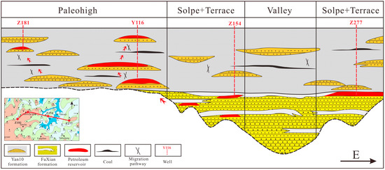
Figure 16.
Schematic diagram summarizing the differential accumulation patterns of different paleogeomorphic units in the Fuxian Formation and Yan 10 oil layer group in the Yanwu area.
In areas controlled by paleohigh units, hydrocarbons migrate along underlying strata and accumulate at unconformities within the Fuxian Formation and Yan-10 reservoirs. Within these units, hydrocarbons preferentially migrate through high-permeability pathways. Wells such as Y116 and Z181, located in paleohigh areas with well-developed pore-throat networks and high flow capacity, illustrate that hydrocarbons are more readily transported to these locations. When overlying mudstone reaches a sufficient thickness, it acts as an effective vertical seal, allowing hydrocarbons to begin accumulating structurally at the high points.
In regions jointly controlled by slopes and paleo-terraces, the reservoirs exhibit superior pore-throat structure, petrophysical properties, and flow capacity, making them favorable accumulation sites. As hydrocarbons migrate upward into these reservoirs, they can form vertical trap seals when capped by mudstone or relatively tight fine-grained sandstones, leading to structural hydrocarbon accumulations at elevated positions. Wells such as Z154 and Z277, where hydrocarbons are observed at the top of the Fuxian Formation, exemplify this type of accumulation. Furthermore, if lateral migration pathways such as structural fractures exist around the sand bodies of slope or paleo-terrace units, hydrocarbons can continue to migrate upward into adjacent reservoirs, forming accumulations in new structural highs.
5.4. Exploration Insights and Future Directions
Distinct hydrocarbon accumulation patterns are observed among different paleogeomorphic units in the Yanwu area. Detailed characterization and restoration of the pre-Jurassic paleogeomorphology effectively explain the distribution of newly discovered reservoirs during block development. Integrating analyses of reservoir pore-throat structures and flow capacities, micro-scale visualized hydrocarbon charging simulations reveal clear differences in flow behavior among reservoir types, enabling a comprehensive assessment of hydrocarbon enrichment across geomorphic units.
This approach not only provides critical guidance for exploration and reserve development in the study area but also offers a methodological reference for analogous regions worldwide with complex paleogeomorphology. Furthermore, advances in high-density well networks and three-dimensional seismic prediction now allow higher-precision, higher-resolution reconstructions of local paleogeomorphic features, enhancing understanding of reservoir distribution and accumulation mechanisms.
It is noteworthy that due to the unique structural context of the study area and the limitations in the number of samples available for the micro-oil and gas injection experiments, future researchers investigating hydrocarbon accumulation models in different blocks should prioritize considering the structural similarities to the context presented in this study when conducting their reference and analysis.
6. Conclusions
This study presents a high-resolution reconstruction of the pre-Jurassic paleogeomorphology in the Yanwu area of the Ordos Basin using the compensated impression method calibrated with 3D seismic profiles. Four geomorphic units—paleohigh, slope, terraces, and valleys—were identified, and seismic validation in the Honghe and Yanwu tributary valleys confirms the accuracy of the reconstructed paleogeomorphic framework.
Based on the reconstructed geomorphic units, reservoir pore-throat structures and flow characteristics were systematically analyzed. Slope and terraces exhibit well-developed intergranular and secondary dissolution pores, moderate pore-throat radii, and low displacement pressures. Micro-scale hydrocarbon charging experiments indicate grid-like displacement patterns with high final recovery efficiencies, reaching 59% in slope zones and 42.1% in terraces. In contrast, reservoirs associated with paleohighs and valleys show stronger heterogeneity, strip-like displacement patterns, poorer flow capacity, and lower recovery efficiencies around 30%.
The differences in reservoir quality and flow mechanisms among geomorphic units correspond to distinct hydrocarbon accumulation models. Paleohighs primarily accumulate hydrocarbons through vertical migration from underlying units and form reservoirs where effective structural or stratigraphic traps exist. Slope zones and terraces, with favorable reservoir properties, act as both preferential accumulation sites and potential migration pathways; effective top seals are required for hydrocarbon retention at structural highs. Consequently, areas within slope zones with adequate sealing and portions of paleohighs with high-quality reservoirs represent key targets for future exploration.
This integrated approach—combining high-resolution paleogeomorphologic reconstruction, seismic calibration, and micro-scale flow visualization—provides a robust framework not only for the Yanwu area but also for other regions of the Ordos Basin with similar structural and reservoir conditions. Furthermore, the methodology is broadly applicable to analogous basins worldwide, offering valuable guidance for hydrocarbon exploration and reservoir evaluation.
Author Contributions
Conceptualization, Y.Z. and Y.H.; methodology, Y.H.; validation, Y.L.; formal analysis, Y.Z. and Y.H.; investigation, J.Y.; data curation, C.L.; writing—original draft preparation, Y.H.; writing—review and editing, Y.H.; visualization, B.W. and M.L.; supervision, Y.Z. and Y.H.; project administration, Y.Z. All authors have read and agreed to the published version of the manuscript.
Funding
This study was supported by technology and data provided by CNPC Changqing Exploration Institute (grant number: CQYT-CQCY11C-2021-JS-2115).
Data Availability Statement
The data that support the findings of this study are available from the corresponding author upon reasonable request.
Conflicts of Interest
Authors Yicang Liu and Jianguo Yu are employed by PetroChina Changqing Oilfield Company. Authors Bing Wang and Conglin Li are employed by PetroChina Yumen Oilfield Company. The remaining authors declare that the research was conducted in the absence of any commercial or financial relationships that could be construed as a potential conflict of interest.
References
- Wang, X.; Fu, G.; Fan, B.; Liu, X. Pre-Jurassic paleogeomorphology restoration and favorable conditions for oil accumulation of the Zhouchang area, Ordos Basin, China. Carbonates Evaporites 2022, 37, 61. [Google Scholar] [CrossRef]
- Dou, L.; Hou, J.; Liu, Y.; Zhang, L.; Song, S.; Wang, X. Sedimentary infill of shallow water deltaic sand bodies controlled by small-scale syndepositional faults related paleogeomorphology: Insights from the paleogene Shahejie formation in the Dongying depression, Bohai Bay Basin, Eastern China. Mar. Pet. Geol. 2020, 118, 104420. [Google Scholar] [CrossRef]
- Wang, Z.; Jiang, H.; Wang, T.; Lu, W.; Gu, Z.; Xu, A.; Yang, Y.; Xu, Z. Paleo-geomorphology formed during Tongwan tectonization in Sichuan Basin and its significance for hydrocarbon accumulation. Pet. Explor. Dev. 2014, 41, 338–345. [Google Scholar] [CrossRef]
- Russell, W.L. Principles of Petroleum Geology, 2nd ed.; Mc-Graw-Hill Book Co.: New York, NY, USA, 1960; pp. 243–250. [Google Scholar]
- Martin, R. Paleogeomorphology and it’s application to exploration for Oil and Gas. AAPG Bull. 1966, 50, 2277–2311. [Google Scholar] [CrossRef]
- Halbotuy, M.T. Geology of Giant Petroleum Fields; American Association of Petroleum Geologists: Tulsa, OK, USA, 1970; pp. 204–222+477–488+449–470. [Google Scholar]
- Magara, K.T. Thickness of removed sedimentary rocks, paleopore pressure and paleotemperature, southwest part of Western Canada bassin. AAPG Bull. 1976, 60, 554–565. [Google Scholar] [CrossRef]
- Carr, T.R.; Anderson, N.L.; Franseen, E.K. Paleogeomorphology of the Upper Arbuckle Karst Surface: Implications for Reservoir and Trap Development in Kansas; AAPG Annual Convention; AAPG: Tulsa, OK, USA, 1994; Volume 3, p. 117. [Google Scholar]
- Wei, X.; Ren, J.; Zhao, J.; Zhang, D.; Luo, S.; Wei, L.; Chen, J. Paleo-geomorphologic characteristic evolution and geological significance of the Ordovician weathering crust in eastern Ordos Basin. Acta Pet. Sin. 2017, 38, 999. [Google Scholar] [CrossRef]
- House, M.A.; Wernicke, B.P.; Farley, K.A. Paleogeomorphology of the central and southern Sierra Nevada; further insights from apatite(U-Th)/He ages. Geol. Soc. Am. 1999, 31, 481–482. [Google Scholar] [CrossRef]
- Han, C.; Lin, C.; Wei, T.; Dong, C.; Ren, L.; Zhang, X.; Dong, L.; Zhao, X. Paleogeomorphology restoration and the controlling effects of paleogeomorphology on karst reservoirs: A case study of an ordovician-aged section in Tahe oilfield, Tarim Basin, China. Carbonates Evaporites 2019, 34, 31–44. [Google Scholar] [CrossRef]
- Yan, H.; Wang, L.; Zheng, M.; He, D.; Xu, W.; Wang, Z.; Zhang, Y.; Jing, X. Paleogeomorphology restoration and its significance in controlling reservoirs: A case study of the fourth member of Sinian Dengying formation in the Moxi area, Sichuan Basin, SW China. Carbonates Evaporites 2024, 39, 116. [Google Scholar] [CrossRef]
- Yu, T.; Liu, H.; Liu, B.; Tang, S.; Tang, Y.; Yin, C. Restoration of karst paleogeomorphology and its significance in petroleum geology—Using the top of the Middle Triassic Leikoupo Formation in the northwestern Sichuan Basin as an example. J. Pet. Sci. Eng. 2022, 208, 109638. [Google Scholar] [CrossRef]
- Yuan, H.; Yin, S.; Dong, L.; Tan, C. Restoration of the pre-Jurassic paleogeomorphology and its control on hydrocarbon distribution in western Ordos Basin. Energy Geosci. 2022, 3, 485–494. [Google Scholar] [CrossRef]
- Wang, T.; Zhang, K.; Xiong, L.; Shi, H.; Dong, X.; Wei, L.; Wen, Z.; Ouyang, J.; Li, B.; Wang, H. Paleogeomorphology restoration of Wufeng Formation-Lower Member of Longmaxi Formation in Zigong area of Sichuan Province and its oil and gas significance. Pet. Geol. Exp. 2018, 40, 764–770. [Google Scholar] [CrossRef]
- Fang, X. Restoration of Paleogeomorphology of Xujiahe Formation in Sichuan Basin and Its Petroleum Geological Significance. In Proceedings of the 3rd International Conference on Green Energy, Environment and Sustainable Development (GEESD2022); IOS Press: Amsterdam, The Netherlands, 2022; pp. 1081–1087. [Google Scholar] [CrossRef]
- Zhu, H.; Li, S.; Shu, Y.; Yang, X.; Mei, L. Applying seismic geomorphology to delineate switched sequence stratigraphic architecture in lacustrine rift basins: An example from the Pearl River Mouth Basin, northern South China Sea. Mar. Pet. Geol. 2016, 78, 785–796. [Google Scholar] [CrossRef]
- Albani, A.D.; Rickwood, P.C.; Quilty, P.G.; Tayton, J.W. The morphology and late Quaternary paleogeomorphology of the continental shelf off Sydney, NSW. Aust. J. Earth Sci. 2015, 62, 681–694. [Google Scholar] [CrossRef]
- Komliev, O.; Remezova, O.; Spitsya, R.; Naumenko, U.; Komlieva, M.; Koval, D.; Zhilkin, S. Paleogeomorphological amber traps of the prypiat amber-bearing basin of the Ukraine (theory and methodology of searches). In IOP Conference Series: Earth and Environmental Science; IOP Publishing: Amsterdam, The Netherlands, December 2024; Volume 1415, p. 012113. [Google Scholar] [CrossRef]
- Van Heteren, S.; Meekes, J.A.C.; Bakker, M.A.J.; Gaffney, V.; Fitch, S.; Gearey, B.R.; Paap, B.F. Reconstructing North Sea palaeolandscapes from 3D and high-density 2D seismic data: An overview. Neth. J. Geosci. 2014, 93, 31–42. [Google Scholar] [CrossRef]
- Li, X.; Guo, Y.B.; Zhang, L.K.; Guo, B.H.; Li, J.F. Study and Application of Seismic Sedimentology in Paleogeomorphology Restoration. In International Field Exploration and Development Conference; Springer: Singapore, September 2020; pp. 1142–1153. [Google Scholar] [CrossRef]
- Li, W.; Mu, L.; Zhao, L.; Li, J.; Wang, S.; Fan, Z.; Shao, D.; Li, C.; Shan, F.; Zhao, W.; et al. Pore-throat structure characteristics and its impact on the porosity and permeability relationship of Carboniferous carbonate reservoirs in eastern edge of Pre-Caspian Basin. Pet. Explor. Dev. 2020, 47, 1027–1041. [Google Scholar] [CrossRef]
- Mustafa, A.; Mahmoud, M.A.; Abdulraheem, A. A review of pore structure characterization of unconventional tight reservoirs. In Abu Dhabi International Petroleum Exhibition and Conference, Abu Dhabi, UAE, 11–14 November 2019; SPE: Richardson, TX, USA, 2019; p. D031S098R001. [Google Scholar] [CrossRef]
- Blasingame, T.A. The characteristic flow behavior of low-permeability reservoir systems. In SPE Unconventional Resources Conference/Gas Technology Symposium, Keystone, CO, USA, 10–12 February 2008; SPE: Richardson, TX, USA, 2008; p. SPE-114168. [Google Scholar] [CrossRef]
- Yang, Y.B.; Xiao, W.L.; Zheng, L.L.; Lei, Q.H.; Qin, C.Z.; He, Y.A.; Liu, S.S.; Li, M.; Li, Y.M.; Zhao, J.Z.; et al. Pore throat structure heterogeneity and its effect on gas-phase seepage capacity in tight sandstone reservoirs: A case study from the Triassic Yanchang Formation, Ordos Basin. Pet. Sci. 2023, 20, 2892–2907. [Google Scholar] [CrossRef]
- Wang, J.; Wu, S.; Li, Q.; Zhang, J.; Guo, Q. Characterization of the pore-throat size of tight oil reservoirs and its control on reservoir physical properties: A case study of the Triassic tight sandstone of the sediment gravity flow in the Ordos Basin, China. J. Pet. Sci. Eng. 2020, 186, 106701. [Google Scholar] [CrossRef]
- He, T.; Zhou, Y.; Li, Y.; Xie, H.; Shang, Y.; Chen, T.; Zhang, Z. Research on the microscopic pore-throat structure and reservoir quality of tight sandstone using fractal dimensions. Sci. Rep. 2024, 14, 22825. [Google Scholar] [CrossRef]
- Cui, H.; Zhu, S.; Wang, J.; Gao, Y.; Wan, C.; Tong, H. Physical properties, pore-throat structure, fractal characteristics and their effects on the gas-bearing capacity of tight sandstone: A case study from the northern tianhuan depression, Ordos Basin, China. Nat. Resour. Res. 2022, 31, 1559–1584. [Google Scholar] [CrossRef]
- Flodin, E.A.; Aydin, A.; Durlofsky, L.J.; Yeten, B. Representation of fault zone permeability in reservoir flow models. In SPE Annual Technical Conference and Exhibition, New Orleans, LA, USA, 30 September–3 October 2001; SPE: Richardson, TX, USA, 2001; p. SPE-71617. [Google Scholar] [CrossRef]
- Zhang, H.; Guo, L.; Wu, Z.; Ma, J. Pore-throat structure, fractal characteristics and permeability prediction of tight sandstone: The Yanchang Formation, Southeast Ordos Basin. Sci. Rep. 2024, 14, 27913. [Google Scholar] [CrossRef] [PubMed]
- Lai, J.; Wang, G.; Wang, Z.; Chen, J.; Pang, X.; Wang, S.; Zhou, Z.; He, Z.; Qin, Z.; Fan, X. A review on pore structure characterization in tight sandstones. Earth-Sci. Rev. 2018, 177, 436–457. [Google Scholar] [CrossRef]
- Khalili, Y.; Ahmadi, M. Reservoir modeling & simulation: Advancements, challenges, and future perspectives. J. Chem. Pet. Eng. 2023, 57, 343–364. [Google Scholar] [CrossRef]
- Guo, J.Z.; Li, Y.; Liu, Z.W.; Han, B.H.; Wang, S. Application of research on regional basic geological law in exploration and reserves increase of jurassic oil reservoir in Yanwu Area, Ordos Basin. In International Field Exploration and Development Conference; Springer: Singapore, September 2020; pp. 2084–2097. [Google Scholar] [CrossRef]
- Ye, B.; Liang, X.W.; Song, J.; Cao, R.; Mao, Z.; Hao, B. Reservoir accumulation characteristics of Jurassic Yan’an Formation in Yanwu area, Ordos Basin. Lithol. Reserv. 2018, 30, 65–73. [Google Scholar] [CrossRef]
- Wang, G.; Wang, X.; Xie, L.; Huang, R. Paleo-geomorphic features of pre-jurassic and its oil-controlling effect in Wuqi–dingbian area. Sci. Rep. 2024, 14(1), 10545. [Google Scholar] [CrossRef]
- Li, R.; Li, Y. Tectonic evolution of the western margin of the Ordos Basin (Central China). Russ. Geol. Geophys. 2008, 49, 23–27. [Google Scholar] [CrossRef]
- Zhou, W.Y.; Jiao, Y.Q.; Zhao, J.H. Sediment provenance of the intracontinental Ordos Basin in North China Craton controlled by tectonic evolution of the basin-orogen system. J. Geol. 2017, 125, 701–711. [Google Scholar] [CrossRef]
- Gu, N.; Zhang, J.; Jin, X.; Yang, F.; Liu, L. Ordovician reservoirs in Fuxian area: Gas accumulation patterns and their implications for the exploration of lower Paleozoic carbonates in the southern Ordos Basin. Energy Geosci. 2024, 5, 100225. [Google Scholar] [CrossRef]
- Xie, L.; Wang, G.; Xi, T.; Cheng, N. Pre-Jurassic Paleogeomorphic Restoration Methods and Characteristics of the Central Ordos Basin. Geol. Min. Eng. 2024, 2, 16–19. [Google Scholar] [CrossRef]
- Yang, Z.; Liu, J.; Lv, Q.; Luo, S.; Zhou, X.; Li, S.; Zhang, Y.; Zhang, X. Paleogeomorphological restoration and its control on gravity flow sand bodies: A case study of the Chang 7 3 submember of the Triassic Yanchang Formation in the Ordos Basin. Bull. Geol. Sci. Technol. 2023, 42, 146–158. [Google Scholar] [CrossRef]
- Bagherzadeh, P.; Goshtasbi, K.; Kazemzadeh, E.; Kashef, M.; Aloki Bakhtiari, H. Stress-dependence of the permeability, porosity, and compressibility in fractured porous media regarding fracturing condition. Bull. Eng. Geol. Environ. 2021, 80, 5091–5110. [Google Scholar] [CrossRef]
- Wang, L.; Zhang, Y. Interpreting correlations in stress-dependent permeability, porosity, and compressibility of rocks: A viewpoint from finite strain theory. Int. J. Numer. Anal. Methods Geomech. 2024, 48, 2000–2019. [Google Scholar] [CrossRef]
- Meng, X.; Wan, Y.; Bai, X. Characterization and origin of a dolomite reservoir in weathering crust: Example from Ordovician in the Tabamiao Region, Northern Ordos, China. Carbonates Evaporites 2018, 33, 195–210. [Google Scholar] [CrossRef]
- Chen, J.Q.; Pang, X.Q.; Chen, D.X. Sedimentary facies and lithologic characters as main factors controlling hydrocarbon accumulations and their critical conditions. J. Palaeogeogr. 2015, 4, 413–429. [Google Scholar] [CrossRef]
- Zhang, L.; Liu, X.; Zhao, Y.; Zhou, Y.; Shan, B. Effect of pore throat structure on micro-scale seepage characteristics of tight gas reservoirs. Nat. Gas Ind. B 2020, 7, 160–167. [Google Scholar] [CrossRef]
- He, W.; Song, Y.; Tang, S.; You, X.; Bai, Y.; Zhao, Y. Hydrocarbon accumulation mechanism of total petroleum system in Permian Fengcheng Formation, Mahu sag. Xinjiang Pet. Geol. 2022, 43, 663. [Google Scholar] [CrossRef]


Disclaimer/Publisher’s Note: The statements, opinions and data contained in all publications are solely those of the individual author(s) and contributor(s) and not of MDPI and/or the editor(s). MDPI and/or the editor(s) disclaim responsibility for any injury to people or property resulting from any ideas, methods, instructions or products referred to in the content. |
© 2026 by the authors. Licensee MDPI, Basel, Switzerland. This article is an open access article distributed under the terms and conditions of the Creative Commons Attribution (CC BY) license.