Abstract
When a navigation constellation depends exclusively on inter-satellite links for autonomous orbit determination, the absence of inertial frame orientation measurements can result in the accumulation of rotational errors across the entire constellation. To address these challenges, this study introduces inter-satellite orientation information in the inertial frame to provide the BeiDou satellite constellation with a stable inertial orientation reference. The results demonstrate that (1) incorporating space-based orientation observations with satellite-to-ground data significantly enhances orbit determination accuracy, reducing the three-dimensional orbit error from 2.604 m to 0.611 m. (2) Introducing a single orientation data point per epoch improves orbit determination accuracy from 2.604 m to 0.982 m. Compared to the scanning mode, the staring mode achieves higher performance. (3) When the error of space-based orientation data remains below 10 mas, the resulting spatial reference frame accuracy is better than 50 cm for the satellites. This research provides technical support for the construction of next-generation BDS.
1. Introduction
In response to the degradation in BeiDou Navigation Satellite System (BDS) service accuracy caused by insufficient deployment of regional monitoring networks, the third-generation BDS (BDS-3) innovatively proposes onboard inter-satellite Ka-band link payload observations. These observations enable full-arc tracking of satellites and compensate for the decay of satellite broadcast ephemeris and clock parameters. By introducing inter-satellite observations and strengthening off-territory arc tracking, the accuracy of satellite orbit and clock offset calculations has been greatly improved. The broadcast ephemeris user range error (URE) is reduced from 30 cm to 10 cm, the clock offset prediction error is decreased from 2.5 ns to 1.2 ns, and the signal-in-space range error (SISRE) is better than 0.5 m [1,2,3]. Moreover, relying on inter-satellite link (ISL) data, the BDS leverages autonomous satellite orbit determination and clock offset calculation technology to enable long-duration autonomous operation of BDS satellites without ground support, significantly increasing their resilient survivability.
Global Navigation Satellite System (GNSS) satellites lack direct measurements in the geocentric inertial frame, whereas satellite motion equations are established and solved in the inertial frame. Therefore, precise orbit determination of GNSS satellites via satellite-to-ground observation data requires the use of Earth orientation parameters (EOPs) to transfer ground station coordinates to the inertial frame, providing a spatial orientation reference for the inertial frame and thereby determining the satellite orbit. When relying solely on satellite-to-ground data for orbit determination, GNSS are unable to estimate the UT1-UTC parameter simultaneously because of the strong linear correlation between UT1–UTC and the right ascension of the ascending node in the satellite orbit. In autonomous orbit determination based on ISL, inaccuracies in orbit perturbation force models and deviations in EOP can induce a systematic rotation of the entire constellation, severely degrading the long-term autonomous operational accuracy of the navigation constellation [4,5]. Existing solutions to this issue fall into two principal categories [6,7]. The first relies on long-term predicted ephemerides uploaded from ground control, which mitigate constellation rotation through a priori constraints on orbital inclination and the right ascension of the ascending node. However, this method is inherently limited by the accumulation of errors in EOP predictions and satellite dynamic models. The second approach uses ground anchor stations to establish a spatiotemporal reference. Nonetheless, this strategy remains susceptible to risks associated with the vulnerability and accessibility of these ground stations. To achieve higher-precision and more robust autonomous operation of the BDS satellite constellation, it is essential to develop an external spatiotemporal reference system that operates independently of ground anchor stations.
The construction of the national comprehensive positioning, navigation, and timing (PNT) system emphasizes the integration of multiple technological means, achieving autonomous satellite orbit determination from star observations by star sensors and angle observations between star sensors and infrared horizon sensors. This approach can reduce satellites’ dependence on the ground and eliminate the overall rotation of the constellation. However, owing to limitations in equipment measurement accuracy, the orbit determination accuracy is relatively low [8]. Chen Jinping et al. [9,10] proposed an autonomous orbit determination method for navigation satellites that is based on inter-satellite distance and direction observations. Their results revealed that adding directional observation data with an angular distance measurement accuracy of 0.1″ significantly improved the solution of orbital plane orientation parameters. This improvement was achieved on the basis of 0.2 m ranging accuracy. Cai Zhiwu et al. [11] used the same method to stabilize the URE accuracy of autonomous orbit determination at 1.2 m within a 60-day arc. Yi Hang et al. [12] adopted a semi-physical system for accurate and reliable simulation of inter-satellite orientation observation information and explored an implementation approach for combined inter-satellite ranging and orientation measurement. Based on the above theoretical methods, Shang Lin et al. [13] employed a stepwise Kalman filtering information fusion algorithm, achieving a ≤1.5 m orbit URE after autonomous constellation orbit determination for 60 d while effectively suppressing the overall rotation error of the constellation. To address the challenges of limited stability and inadequate fault recovery in ISL-based autonomous orbit determination algorithms, Lin Xia et al. [14] proposed a celestial navigation information guidance algorithm that markedly enhances system robustness. In recent years, optical inter-satellite links (OISLs) have garnered significant attention because of their superior precision in ranging and narrow-beam measurement capabilities. Pratik et al. [15] studied a distributed autonomous spacecraft navigation method utilizing OISLs and developed a comprehensive simulation framework encompassing various orbital regimes, including low Earth orbit (LEO), geostationary Earth orbit (GEO), highly elliptical orbit (HEO), and Mars orbits. Their findings indicate that, relative to conventional approaches, laser communication systems can facilitate long-distance inter-satellite ranging and orientation measurements with substantially improved accuracy. In addition, Peter et al. [16] advanced the theoretical modeling of OISL-based navigation by analyzing the physical sources of error in ranging, velocity, and orientation measurements. Their study demonstrated that laser communication crosslinking not only enhances the data throughput of satellite communication constellations but also serves as a critical enabler for high-precision autonomous navigation systems.
The above studies focus on the theoretical fusion of inter-satellite distance and direction observation data, and related verification often adopts data simulation or semi-physical simulation methods, qualitatively verifying the correctness of the theoretical methods. Despite recent advancements, there remains a lack of empirical data support and a deficiency in systematic research on space-based orientation observation modes. In particular, the influences of star sensor deployment strategies, measurement accuracy requirements, single-epoch data acquisition volume, and observation mode configurations on orbit determination performance have not been thoroughly investigated.
In this paper, the method of eliminating the overall rotation of the BeiDou satellite constellation based on space-based orientation observations is introduced in Section 2. The orbit determination approach for BDS satellites using multi-source data is described in Section 3. The simulation method and observation mode for space-based orientation data are presented in Section 4. The experimental validation results are provided in Section 5, and the conclusions are drawn in Section 6.
2. Method of Eliminating the Overall Rotation of the BeiDou Satellite Constellation Based on Space-Based Orientation Observations
As to the constellation rotation in the autonomous orbit determination of BeiDou satellites, this section introduces a method for eliminating such rotation based on space-based orientation observations. Star sensors mounted on the observation satellite [17] are employed to perform orientation observations of both the target satellite and background stars. The captured images are processed to extract angular distance measurements between the observation satellite, the target satellite, and the background stellar field. Using these measurements, the orientation parameters of the involved satellites are computed, allowing for the determination of the direction vector connecting the navigation satellites within the inertial frame. This space-based orientation observation technique enables the determination of the absolute orientation of the satellite constellation relative to the inertial coordinate system, effectively mitigating overall constellation rotation. The detailed derivation of the methodology is presented below.
The satellite coordinates determined using only inter-satellite link (ISL) data are denoted as , , , where the superscript “ISL” indicates that it is a vector in a coordinate system derived from ISL data processing. This coordinate system exhibits an overall rotation relative to the inertial frame (e.g., ICRF). Denoting the satellite coordinates in the inertial frame as , , and the rotation vector as , the following relationship holds according to the coordinate transformation principle:
where represents the rotation matrix, with , , and denoting the rotation matrices about the X-axis, Y-axis, and Z-axis, respectively.
For any three satellites A, B, and C, the following relationship holds:
Two relative direction vectors are constructed between satellites A and B, and between satellites A and C.
In the above equation, the terms and on the left side can be measured by onboard equipment (e.g., star sensors). The terms and are relative vectors derived from the coordinates , and , which are solved based on inter-satellite links. The quantities and represent inter-satellite distances. All these parameters are known, allowing the unknown rotation angle to be solved.
It can be concluded that by constructing two independent sets of relative direction parameters (e.g., and ) using star sensors, the overall rotation angle of the constellation relative to the inertial frame can be indirectly determined. This approach resolves the spatial orientation problem of the navigation constellation in the inertial frame.
3. Orbit Determination Method for BDS Satellites Integrating Satellite-to-Ground, Inter-Satellite, and Space-Based Orientation Observations
This section introduces an orbit determination method that integrates satellite-to-ground, inter-satellite, and space-based orientation observations to address the overall constellation rotation in the autonomous orbit determination of BeiDou satellites. Figure 1 illustrates the inter-satellite orientation observation model. In the depicted celestial coordinate system, the axis definitions are consistent with those of the J2000.0 geocentric equatorial inertial reference frame.
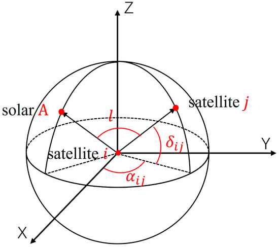
Figure 1.
Schematic diagram of the ISL orientation observation model.
Let denote the right ascension and declination of star A, and let denote the right ascension and declination in the direction of the line connecting observation satellite and target satellite , where observation satellites and target satellite refer to any satellites within the constellation. Then, according to the cosine theorem for spherical triangle sides, the theoretical angular distance between the points projected on the celestial sphere by the lines connecting the star and observation satellite and target satellite can be written as follows:
The right ascension and declination of the star can be retrieved from the stellar catalog. For the measurement equation, the angular distance measurement equation can be directly employed, or the right ascension and declination of the satellite-to-satellite connection can be obtained after comprehensive processing of the angular distance. In this work, the right ascension and declination are taken as observation values.
can be obtained via the following expressions:
where , , and represent the position vectors of satellite i and satellite j in the inertial frame, respectively.
The BDS-3 satellites adopt the Ka-band ISL for inter-satellite measurements, with a time slot of 3 s. The forward and reverse inter-satellite ranging values observed in each time slot are reduced to the same epoch [18,19]. The relative distance between satellites is obtained by adding the reduced bidirectional ranging values and is used for satellite orbit determination, as shown in the following equation:
where is the relative distance between satellites and at the reduction epoch ; and are the forward and reverse ranging values at ; and are the three-dimensional position vectors of the satellites; , , , and denote the transmission and reception delays of the ISL equipment between satellites and ; and represent the model corrections of the two ranging values, including the satellite antenna phase center correction and the relativistic effect correction; is the random noise in inter-satellite measurements; and is the speed of light.
The pseudorange and phase measurements between satellite and ground station are determined using the following equations:
where is the distance between the ground receiver and satellite i at the reduction epoch, is the pseudorange observation value, denotes the phase observation value, and are the positions of the ground receiver and satellite i at the reduction epoch, λ indicates the frequency, is the ionospheric delay correction, reflects the tropospheric delay correction, is the clock offset of the ground receiver, is the clock offset of the satellite, is the integer ambiguity, ε is the measurement noise, and c denotes the speed of light.
The measurement equation is established by combining the relative distance between satellites at time , the space-based orientation observation values , , and the satellite-to-ground distance as the observation quantity at . The parameters to be estimated include the orbit parameters (including position and velocity), dynamic model parameters, and ambiguity parameters of the BeiDou satellites.
where represents the parameters to be estimated, including the initial position and velocity, dynamic parameters (optical pressure), tropospheric model parameters, and ambiguity of all BeiDou satellites; is the orbit parameter design matrix, which represents the relationship between the observation quantity and the orbit parameter vector; and is the noise vector in the orbit observation.
Here, the observation partial derivatives between the space-based orientation data and orbital parameters to be estimated are expressed by
The partial derivative matrix corresponding to space-based orientation data with respect to dynamic parameters (e.g., optical pressure), tropospheric model parameters, and ambiguity terms is null. The partial derivative matrices for satellite-to-ground and inter-satellite link measurements are available in the literature [20,21,22]. By utilizing these three categories of measurement data, the least squares method is employed to estimate the orbital parameters, dynamic parameters, and ambiguity terms of the BeiDou satellites.
4. Simulation of Space-Based Orientation Observation Data and Observation Mode Design
To evaluate the effectiveness of the proposed BeiDou satellite orbit determination approach, this study integrates satellite-to-ground, inter-satellite, and space-based orientation observations. A combination of measured and simulated datasets is utilized for the evaluation. Specifically, satellite-to-ground and inter-satellite data are sourced from actual BDS measurements, while space-based orientation data are synthetically generated. This section details the simulation methodology and the associated error modeling framework for orientation observations. Three distinct observation strategies have also been developed to examine how varying observation modes influence orbit determination accuracy. These strategies provide strategic guidance for the future design of autonomous navigation systems in the BeiDou constellation.
4.1. Simulation and Error Modeling of Space-Based Orientation Observation Data
As no actual space-based orientation observations currently exist for BeiDou satellites, such data must be generated through simulation. This section describes the methodology employed for this simulation. Initially, error-free right ascension and declination values for both the target and observation satellites are produced using the inertial-frame orbits of the BeiDou constellation and corresponding stellar observation ephemerides. A measurement error model is subsequently constructed by thoroughly analyzing the operational principles and error characteristics of the star sensors. Finally, varying levels of simulated measurement noise are superimposed onto the right ascension and declination data to produce realistic space-based orientation observations for use in orbit determination analyses.
This study simulates space-based orientation measurement data based on the BDS satellite precise ephemeris provided by the Multi-GNSS Experiment (MGEX) [23] and the EOP product issued by the International Earth Rotation Service (IERS) [24]. Ignoring the actual generation process of onboard photogrammetric data, the simulation process is as follows:
(1) Obtain the precise ephemeris and corresponding precise EOP products and perform coordinate system conversion.
The generation of precise ephemerides follows the standards of the International Terrestrial Reference Frame (ITRF). To simulate orientation measurements in a celestial coordinate system, it is essential to employ EOP provided by the International IERS or derived from the precise ephemeris itself. The transformation process involves applying corrections for polar motion, performing a rotation based on the true equinox hour angle, and incorporating precession and nutation effects. This conversion yields the required celestial-frame data, which serve as the basis for simulating space-based orientation measurements.
(2) Determine whether inter-satellite visibility is satisfactory.
The criterion for determining inter-satellite visibility is whether one satellite is within the visible angle range between the positive and negative zenith angles of another satellite. Inter-satellite visibility is a prerequisite for inter-satellite orientation measurements.
(3) Calculate the unit vector between satellites in the celestial coordinate system.
(4) The observation error is simulated, and the orientation measurement data in the celestial coordinate system are generated.
Star sensors are subject to multiple sources of measurement error, including uncalibrated systematic biases, stochastic measurement noise, and periodic low-frequency errors (LFE) resulting from thermal deformation of the optical head and its mounting structure. These error components must be incorporated into the data simulation process to ensure realism, as represented by the following equations [25,26,27]:
The precise ephemeris utilized in this study is sourced from the MGEX. The terms “” and “” denote the simulated errors associated with the right ascension and declination, respectively. In the simulation framework, both Gaussian white noise and a constant systematic bias are incorporated. The constant systematic bias of the space-based orientation data can be solved by a data processing method, and then the systematic difference solved can be deducted from the original measurement data, so as to eliminate the influence of systematic bias on the orbital accuracy. The systematic bias of the space-based orientation data in our manuscript is the residual systematic error after data processing modification. The amplitude of the white noise is fixed at 5 mas, while various magnitudes of systematic deviation are introduced to assess their influence on the accuracy of orbit determination.
4.2. Design of the Space-Based Orientation Observation Mode
In the BeiDou system, geosynchronous Earth orbit (GEO) satellites are primarily responsible for tasks such as regional enhancement message broadcasting, regional short message communication, global short message services, and other specialized missions. Due to the numerous payloads installed on GEO satellites, it is not feasible to equip them with star sensors. In comparison with medium Earth orbit (MEO) satellites, inclined geosynchronous orbit (IGSO) satellites operate at a higher orbital altitude. Deploying star sensors on IGSO satellites offers distinct advantages: when measuring MEO satellites in different orbital planes, the required gimbal rotation angle of the star sensor is relatively small. This contributes to improved measurement stability and extended service life of the sensor, while also providing larger measurement coverage. Deploying star sensors on MEO satellites would not offer these advantages.
On the basis of the BDS-3 satellite constellation configuration and platform characteristics, this paper proposes deploying star sensors on three inclined IGSO satellites. It conducts experiments based on the following three observation modes:
(1) Mode 1: Staring.
In this measurement mode, the three IGSO satellites continuously observe the 24 Medium Earth Orbit (MEO) satellites. The MEO satellites are arranged across three orbital planes, with each IGSO satellite maintaining a fixed observation link to a visible MEO satellite within a designated plane. If the initially linked MEO satellite becomes obscured, the IGSO satellite transitions to any other visible MEO satellite within the same orbital plane to continue observations. Under this configuration, orientation measurements are recorded at 15 min intervals, yielding one observation per IGSO satellite at each epoch and a total of three orientation measurements across the three IGSO satellites per observation cycle.
(2) Mode 2: 1 h scanning.
In this measurement mode, the three IGSO satellites perform rotational observations of the MEO satellites. Based on the operational capabilities of the star sensors, the scanning interval is set to about one hour. During each observation cycle, an IGSO satellite establishes a fixed link with a visible MEO satellite within a designated orbital plane. At the start of the next cycle, the IGSO satellite switches to a different orbital plane and selects a new visible MEO satellite for continued observation. This process is mirrored by the other IGSO satellites, ensuring that, at any given time, each of the three MEO orbital planes maintains at least one active observation link with an IGSO satellite. This rotational observation cycle is repeated continuously, generating three orientation measurement records at each 15 min sampling interval, with IGSO-to-MEO satellite pairings updated every hour.
(3) Mode 3: 8 h scanning.
This mode is the same as Mode 2 except that the switching interval becomes 8 h.
5. Experimental Analysis
This section employs measured data from the L-band satellite-to-ground links (GRD) and Ka-band ISL involving the 24 MEO and 3 IGSO satellites of the BDS-3 constellation. Previously simulated space-based orientation data (OPT) are also included to assess the influence of space-based orientation observations on satellite orbit determination accuracy. A detailed analysis is conducted to examine how the number of orientation measurements, their associated errors, and the adopted observation modes affect the precision of BeiDou satellite orbit determination.
Precise orbit determination primarily encompasses four components: the satellite dynamic model, measurement model, parameter estimation methodology, and orbit determination strategy. The latter three elements have been extensively discussed in References [21,22,28] and are not reiterated here. In this study, data from four MGEX ground stations located in China (utilizing B1I/B3I frequency bands) are employed, in conjunction with ISL measurements and simulated orientation data, to conduct three-day arc orbit determination for BDS-3 satellites. The dataset corresponds to October 2020, with the ISL data sourced from actual observations and the space-based orientation data derived from simulations. Orientation measurements are generated at 15 min intervals. The baseline strategy for orbit determination is summarized in Table 1.

Table 1.
Joint orbit determination strategy based on multisource data from BeiDou satellites.
5.1. Accuracy Analysis of BeiDou Satellite Orbit Determination Integrated with Space-Based Orientation Observation
This section examines the influence of space-based orientation data on the orbit determination accuracy of BeiDou satellites under two scenarios: using only satellite-to-ground observations and using combined satellite-to-ground and inter-satellite observations. Inter-satellite visibility is assumed to permit orientation measurements, with white noise set at 5 mas, no constant bias, and a sampling interval of 15 min. The root mean square (RMS) error of the orbit determination is computed, and the radial, tangential, and normal components of the error for each satellite are presented in Figure 2. The left panel compares the orbit determination accuracy of the BeiDou satellites using satellite-to-ground data alone with that via satellite-to-ground data combined with orientation observations. The right panel contrasts the results obtained from satellite-to-ground/inter-satellite data with those incorporating additional orientation observations. A summary of the statistical impact of orientation data on the orbit determination accuracy of BDS-3 satellites is provided in Table 2.
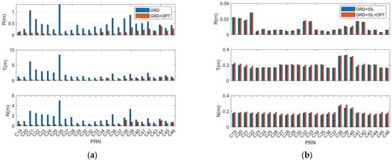
Figure 2.
Statistics of the precise orbit determination results for the BeiDou satellites: (a) Satellite-to-ground GRD data and satellite-to-ground GRD + orientation OPT data; (b) satellite-to-ground GRD + inter-satellite ISL data and satellite-to-ground GRD + inter-satellite ISL + orientation OPT data.

Table 2.
Statistics of the impact of orientation data on the orbit accuracy of BeiDou satellites (unit: m).
The following conclusions can be drawn:
(1) After the orientation observation data are introduced, the precise orbit determination accuracy is significantly improved compared with that of the scheme with only satellite-to-ground measurements. The average accuracy can reach 0.130, 0.459, and 0.381 m in the radial, tangential, and normal directions, respectively. Further, the three-dimensional accuracy is 0.611 m, representing an increase of 76%. In addition, the figure shows that the orbit accuracy of satellites with a PRN code greater than C37 is significantly lower than that of the other satellites, mainly because of their limited ground tracking data and lack of orientation simulation data.
(2) Incorporating orientation measurements does not improve the precision of orbit determination accuracy on the basis of satellite-to-ground/inter-satellite observation data. However, no significant gap exists between the two approaches. After the introduction of space-based orientation measurements, the three-dimensional orbit accuracy decreases from 0.265 m to 0.279 m. This slight reduction of 5.3% is reflected mainly in the normal direction of the satellite orbit. When the error of the space-based orientation data is 5 mas and the inter-satellite distance of the BeiDou satellites is taken as 40,000 km, this angular measurement accuracy corresponds to an inter-satellite range error of approximately 0.96 m. The Ka-band inter-satellite ranging accuracy is about 0.09 m. The weighting of measurement data depends on their respective accuracies. Denoting the error of the angular measurement data as σ1 and the error of the Ka inter-satellite ranging data as σ2, the weighting ratio between the angular measurement data and the Ka inter-satellite ranging data in data processing is (σ1/σ1)2 ≈ 100:1. Therefore, in the orbit determination process, the Ka inter-satellite ranging data play a decisive role in orbit accuracy, while the angular measurement data are primarily used to correct the constellation’s overall rotation. Consequently, the space-based measurements can not improve the orbital accuracy.
Figure 3 illustrates the changes in orbit determination accuracy for satellite C25 following the incorporation of orientation measurement data, offering a more intuitive understanding of the role of orientation observations in enhancing BeiDou satellite orbit precision. In the comparison between GRD and GRD + OPT, the inclusion of orientation data leads to significant improvements across the radial, tangential, and normal components. In contrast, when comparing GRD + ISL with GRD + ISL + OPT, the orientation data primarily enhance accuracy in the normal direction, with comparatively minor effects on the radial and tangential components.
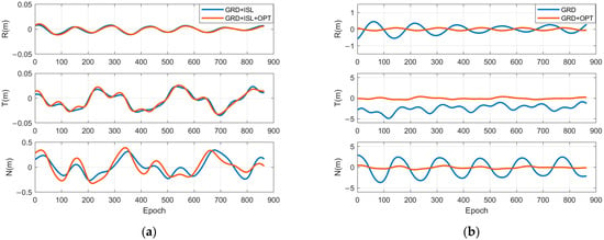
Figure 3.
Statistics of the precise orbit determination results for the BeiDou satellite C25: (a) GRD data and GRD + OPT data; (b) GRD + ISL data and GRD + ISL + OPT data.
Compared with the scheme based on satellite-to-ground/inter-satellite data, the accuracy of the scheme based on satellite-to-ground/inter-satellite/orientation data is slightly lower. Therefore, space-based orientation observation data can be used as an emergency backup for ISL data, although not as regular data. The introduction of space-based orientation observation data, in addition to satellite-to-ground and inter-satellite data, does not aim to improve the orbit determination accuracy of BeiDou satellites. Instead, it is intended to resolve the overall rotation of the BeiDou constellation in the inertial frame.
5.2. Application Strategy Analysis for Space-Based Orientation Observation
The preceding section examined the effect of space-based orientation observation data on the accuracy of satellite orbit determination. This section extends the analysis by investigating how variations in orientation measurement error, observation frequency, and observation mode influence the orbit determination accuracy of BeiDou satellites.
5.2.1. Influence of Inter-Satellite Orientation Single-Epoch Measurement Count on the Orbit Determination Accuracy of BeiDou Satellites
This section presents a detailed analysis of how different satellite orientation measurement configurations affect the regional orbit determination accuracy of BeiDou satellites. The analysis is based on satellite-to-ground data collected from four regional stations and simulated space-based orientation data, excluding inter-satellite observations. The number of orientation measurements per epoch is varied across five levels—0 (ground-based observations only), 1, 3, 6, and the maximum permitted by inter-satellite visibility—at 15 min intervals. The simulated orientation data are modeled with a white noise level of 5 mas and no systematic bias.
Figure 4 presents the precise orbit determination results for BDS-3 satellites in the radial, tangential, and normal directions, corresponding to varying numbers of single-epoch orientation measurements.
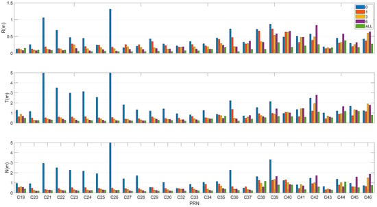
Figure 4.
Precise orbit determination results for BeiDou satellites supported by different numbers of single-epoch inter-satellite orientation measurement data.
The RMSs of the three-dimensional orbit errors for satellite orbit determination and the accuracies of the BeiDou satellite orbit determination under different orientation measurement counts are summarized in Table 3.

Table 3.
Orbit determination accuracy statistics of the BeiDou satellites under different orientation measurement counts (unit: m).
The figure and table show that the orbit determination accuracies are 2.650, 0.982, 0.933, 0.943, and 0.611 m when the satellite orientation measurement counts are 0, 1, 3, 6, and all, respectively. Adding even one inter-satellite orientation record can significantly increase the BDS-3 orbit determination accuracy. As the number of inter-satellite orientation measurements increases, the orbital quality gradually improves.
To further illustrate the influence of single-epoch inter-satellite orientation measurement counts on the orbit determination accuracy, Figure 5 displays the radial, tangential, and normal orbit determination results for satellite C25 under varying numbers of orientation measurement records.
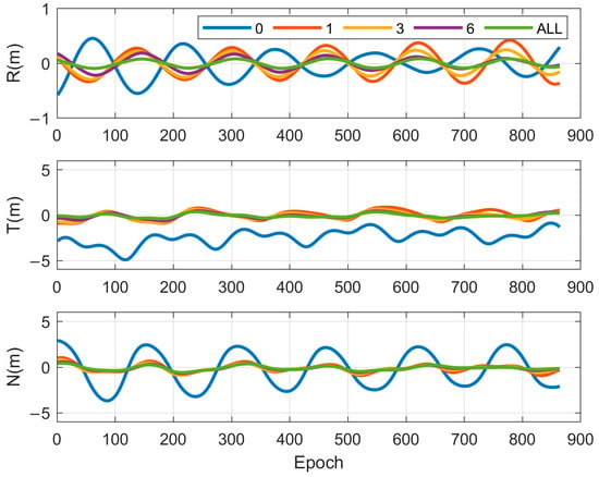
Figure 5.
C25 orbit determination results supported by different single-epoch orientation measurement counts.
Once orientation data are added, the accuracy of orbit determination in all three directions is significantly improved. With more observation data per epoch, a certain improvement in orbit quality is observed. On the basis of the BeiDou satellite constellation, platform characteristics, and engineering implementation cost, this paper proposes the deployment of star sensors on three BDS-3 IGSO satellites. Therefore, for the staring, 1 h scanning, and 8 h scanning measurement modes, the number of orientation observation data points is three per epoch.
5.2.2. Influence of the Space-Based Orientation Observation Mode on the Orbit Determination Accuracy of BeiDou Satellites
Based on the three observation modes defined in Section 4.2, the orientation data are modeled with random noise following a normal distribution, characterized by an RMS error of 3 mas. The constant systematic errors assigned to the three orbital planes are set at 2 mas, –2 mas, and 4 mas. The dataset includes satellite-to-ground observations from four regional stations, ISL data, and simulated space-based orientation measurements. The orbit determination accuracies of the BDS-3 satellites in the IGSO satellite staring mode, 1 h scanning mode, and 8 h scanning mode are summarized in Figure 6.
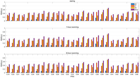
Figure 6.
Orbit determination accuracy maps of the BeiDou satellites under different space-based orientation observation modes.
The orbit determination accuracy statistics of the BDS-3 satellites under different space-based orientation observation modes are shown in Table 4.

Table 4.
Orbit determination accuracy statistics of BeiDou satellites under different inter-satellite orientation modes (unit: m).
To further demonstrate the impact of the observation mode on the orbit determination accuracy, Figure 7 presents the radial, tangential, and normal orbit determination results of satellite C25, which are supported by data from different observation modes.
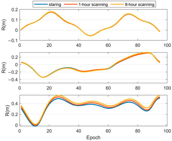
Figure 7.
C25 orbit determination results supported by data from different single-epoch observation modes.
The following conclusions can be drawn from the table and figure:
(1) Compared with the observation mode, in which the three IGSO satellites continuously stare at the MEO satellites, the rotational observation mode yields slightly reduced orbit determination accuracy for the BeiDou satellites.
(2) The orbit determination accuracy achieved in the 1 h scanning mode surpasses that achieved in the 8 h scanning mode. This suggests that increased observation rotation frequency contributes to improved orbit determination accuracy.
(3) The orbit determination accuracies corresponding to the three observation modes are 0.455 m, 0.485 m, and 0.494 m, respectively, indicating only marginal differences among them.
To enhance the measurement stability of the star sensor and extend its service life, the rotation of the sensor’s gimbal should be minimized. It is therefore recommended to adopt a staring mode during the engineering implementation.
5.2.3. Influence of the Inter-Satellite Orientation Measurement Error on the Orbit Determination Accuracy of BeiDou Satellites
In practical star sensor measurement environments, due to the processing of satellite star sensor payloads and the influence of space environments, certain observation errors or noise may occur. This section systematically evaluates the impact of inter-satellite orientation observation system errors on the accuracy of orbit determination for the BeiDou satellites.
Space-based orientation observations were performed in the 1 h scanning observation mode. The orbit is jointly determined by space-based orientation observation data, satellite-to-ground data from 4 regional stations, and ISL data. The random noise of the space-based orientation observation data follows a normal distribution with an RMS error of 5 mas. The constant system error is set as follows.
Option I: The constant system errors on the three orbital planes of the MEO satellite are set to 0.02, –0.02, and 0.04 mas.
Option II: The constant system errors on the three orbital planes of the MEO satellite are set to 0.2, –0.2, and 0.4 mas.
Option III: The constant system errors on the three orbital planes of the MEO satellite are set to 2, –2, and 4 mas.
Figure 8 presents the radial, tangential, normal, and three-dimensional orbit determination results under varying levels of systematic error in the space-based orientation observation system. A comparative analysis of these results enables an intuitive assessment of how different noise levels in orientation measurements impact the regional precise orbit determination performance of BeiDou satellites.
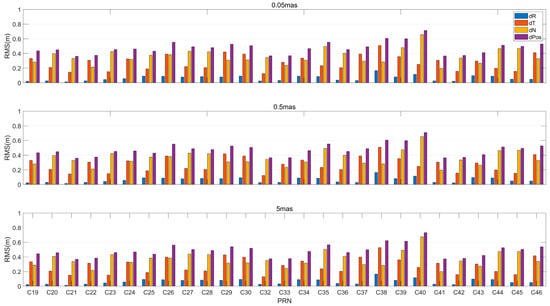
Figure 8.
Precise orbit determination results for the BeiDou satellites.
The figure shows that as the observation error in the stellar angular distance measurement increases, the orbit determination accuracy gradually decreases. The RMS values of the three-dimensional orbit error are recorded, and the BeiDou satellite orbit determination accuracies under different orientation measurement errors are summarized in Table 5.

Table 5.
Orbit determination accuracy statistics for the BeiDou satellites under different orientation measurement errors (unit: m).
When the observation errors are 0.05, 0.5, and 5 mas, the three-dimensional orbit errors are 0.473, 0.475, and 0.486 m, respectively. Therefore, the comprehensive error, including measurement noise and system error, is better than 10 mas, which enables the space-based spatial reference frame of navigation satellites to achieve accuracy better than 50 cm.
At present, the measurement accuracy of star sensors manufactured by the Chinese industrial sector can reach about 10 mas. The errors include both Gaussian white noise and a constant systematic bias. The constant systematic bias of the space-based orientation data can be solved by the data processing method, and then the systematic difference solved can be deducted from the original measurement data, so as to eliminate the influence of systematic bias on the orbital accuracy. In future research, we will study the data processing method of the systematic bias of the space-based orientation data.
6. Conclusions
This study systematically investigates the impact of space-based orientation observations on the orbit determination accuracy of BeiDou satellites. The following conclusions are drawn:
(1) Incorporating space-based orientation data with satellite-to-ground data can significantly improve the orbital accuracy of BeiDou satellites. The three-dimensional accuracy is improved from 2.604 m to 0.611 m. However, the orbital accuracy enhanced by it is comparable to that of the satellite-to-ground/ISL data. Therefore, space-based orientation observation is primarily used to solve constellation rotation in the inertial frame.
(2) The inclusion of even a single inter-satellite orientation measurement yields a substantial improvement in the orbit accuracy of BDS-3 satellites. On the basis of the configuration of the BeiDou satellite constellation and the characteristics of the satellite platform, we suggest that star sensors be deployed on three IGSO satellites, then the number of orientation observation data points per epoch can be set to three.
(3) Three space-based orientation observation modes are proposed: staring, 1 h scanning, and 8 h scanning. The corresponding three-dimensional orbital accuracies are 0.455 m, 0.475 m, and 0.494 m, respectively. We suggest that the staring mode be adopted in future Beidou systems.
(4) When the error of space-based orientation data remains below 10 mas, the space-based spatial reference frame for navigation satellites can achieve an accuracy better than 50 cm.
(5) The method proposed in our paper can also be applied to other navigation constellations, such as GPS and Galileo, when operating in autonomous mode. Although these systems possess globally distributed ground stations, they cannot rely on EOP uploaded by ground stations to eliminate the overall rotation of the constellation in the inertial frame under such conditions. Regarding Starlink satellites, the method presented in this paper can also be used for orbit determination when onboard GNSS data is unavailable.
Author Contributions
Conceptualization, X.L. and S.Z.; methodology, X.L. and S.Z.; software, X.L. and G.C.; validation, X.L., T.Z. and S.W.; formal analysis, X.L., L.Z. and Y.Z.; investigation, X.L., T.Z. and Y.L.; resources, X.L., L.Z. and Y.Z.; data curation, X.L., Y.L. and G.C.; writing—original draft preparation, X.L. and G.C.; writing—review and editing, X.L. and G.C. All authors have read and agreed to the published version of the manuscript.
Funding
This research was funded by the Foundation Strengthening Plan Technology Field Fund Project, the funder is China Science and Technology Committee, the funding number 2024-JCJQ-JJ-0336; National Natural Science Foundation of China, the funder is National Natural Science Foundation of China, the funding number 112173072; Key Program of the Chinese Academy of Sciences, the funder is Chinese Academy of Sciences, the funding number KGFZD-145-25-07. The APC was funded by the Beijing Satellite Navigation Center.
Data Availability Statement
The Multi-GNSS Experiment (MGEX) data used in this study are publicly available from the GNSS Research Center at Wuhan University via the following link: http://www.igs.gnsswhu.cn/index.php (accessed on 4 Feburary 2020 to 7 Feburary 2020). However, the inter-satellite link measurements and space-based orientation data cannot be made openly available due to data privacy and security policies. We appreciate your understanding and support regarding this restriction. For further inquiries about the data, please contact the corresponding author.
Acknowledgments
This work was supported by the open-access Multi-GNSS Experiment (MGEX) data provided by the GNSS Research Center at Wuhan University. We sincerely appreciate their efforts in collecting, processing, and sharing high-precision GNSS observations, which significantly contributed to the findings of this study.
Conflicts of Interest
The authors declare no conflicts of interest.
References
- Cao, Y.-L.; Hu, X.-G.; Zhou, S.-S.; Liu, L.; Wu, X.-L.; Su, R.-R.; Chang, Z.-Q.; He, F.; Wu, B. The Method for Real-time Wide Area Differential Corrections of BDS with Inter Satellite Links. Prog. Astron. 2015, 33, 122–133. [Google Scholar]
- Jing, X.; Che, T.; Zhou, S.; Li, J.-W. Comparative analysis of broadcast ephemeris accuracy before and after the opening of BDS-3 system. GNSS World China 2022, 47, 23–30. [Google Scholar]
- Yang, Y.; Liu, L.; Li, J.; Yang, Y.; Zhang, T.; Mao, Y.; Sun, B.; Ren, X. Featured services and performance of BDS-3. Sci. Bull. 2021, 66, 2135–2143. [Google Scholar] [CrossRef] [PubMed]
- Ananda, M.P.; Bernstein, H.; Cunningham, K.E.; Feess, W.A.; Stroud, E.G. Global Positioning System (GPS) autonomous navigation. In Proceedings of the IEEE Position Location & Navigation Symposium, Salt Lake City, UT, USA, 28 April–1 May 2025; IEEE: Piscataway, NJ, USA, 2002. [Google Scholar]
- Menn, M.D.; Bernstein, H. Ephemeris Observability Issues in the Global Positioning System (GPS) Autonomous Navigation (AUTONAV); IEEE: Piscataway, NJ, USA, 1994. [Google Scholar]
- Shang, L.; Ren, Q.; Zhang, R.; Li, G. Eliminating Constellation Rotation Error of Autonomous Orbit Determination Using Differential Anchor Stations. Geomat. Inf. Sci. Wuhan Univ. 2013, 38, 920–924. [Google Scholar]
- Mao, Y.; Hu, X.; Song, X.; Chen, Y.; Jia, X.; Wu, X. Satellite autonomous navigation algorithm analysis based on broadcast ephemeris parameters. Sci. Sin. Phys. Mech. Astron. 2015, 45, 83–91. [Google Scholar] [CrossRef]
- Li, J.-F.; Zhang, Z.-G. Study on the Orbit and Attitude Control of Spacecraft Formation Flying. Appl. Math. Mech. 2008, 9, 38–46. [Google Scholar]
- Jinping, C.; Zheng, Y.; Wenhai, J. Research on Autonav of Navigation Satellite Constellation Based on Crosslink Range and Inter-satellites Orientation Observation. J. Astronaut. 2005, 26, 43–46. [Google Scholar]
- Chen, J.; Jiao, W.; Ma, J.; Song, X. Autonav of Navigation Satellite Constellation Based on Crosslink Range and Orientation Parameters Constraining. Geomat. Inf. Sci. Wuhan Univ. 2005, 30, 439–443. [Google Scholar]
- Han, C.-H.; Chen, J.-P.; Xu, T. Constellation Rotation Error Analysis and Control in Long-term Autonomous Orbit Determination for Navigation Satellites. J. Astronaut. 2008, 29, 522–528. [Google Scholar]
- Yi, H.; Xu, B.; Gao, Y.-T. Hardware in-the-loop Simulation of Long-term Autonomous Orbit Determination for Navigation Constellation. J. Syst. Simul. 2013, 25, 950–956. [Google Scholar]
- Shang, L. An Information Fusion Algorithm of Autonomous Orbit Determination Based-on Step Kalman Filter. J. Astronaut. 2013, 34, 333. [Google Scholar]
- Lin, X. An Inter-Satellite Link Autonomous Navigation Algorithm Based on Celestial Navigation Information Guidance. J. Astronaut. 2021, 42, 230. [Google Scholar]
- Dave, P.K. Autonomous Navigation of Distributed Spacecraft using Intersatellite Laser Communications. Ph.D. Thesis, Massachusetts Institute of Technology, Boston, MA, USA, 2020. [Google Scholar]
- Grenfell, P. Systems Performance Analysis for Autonomous Spacecraft Navigation Within Satellite Constellations Using Intersatellite Optical Communications Links. Ph.D. Thesis, Massachusetts Institute of Technology, Boston, MA, USA, 2024. [Google Scholar]
- Baohua, L.; Guoliang, L.; Rui, L.; Changhong, W. Key techniques of star sensors for celestial navigation. Opt. Precis. Eng. 2009, 17, 1615–1620. [Google Scholar]
- Zhang, H.; Zhou, X.; Wang, X.; Tian, H. Survey of technology status and development of all-time star sensors in near-earth space. Acta Aeronaut. Astronaut. Sin. 2020, 41, 13. [Google Scholar]
- Tang, C.; Hu, X.; Zhou, S.; Pan, J.; Guo, R.; Hu, G.; Zhu, L.; Li, X.; Xu, S.; Wang, Y. Centralized autonomous orbit determination of Beidou navigation satellites with inter-satellite link measurements: Preliminary results. Sci. Sin. Phys. Mech. Astron. 2017, 47, 95–105. [Google Scholar] [CrossRef]
- Ye, X.; Liu, W.; Zuo, Y.; Wang, W.; Wang, H.; Chang, J.; Wang, F. Analysis of BDS-3 distributed autonomous navigation based on BeiDou system simulation platform. Adv. Space Res. 2021, 67, 401–410. [Google Scholar] [CrossRef]
- Song, X.; Yang, Y.; Mao, Y.; Ruan, R.; Wang, L. Schmidt Kalman filter in autonomous orbit determination of navigation satellites. Acta Geod. Cartogr. Sin. 2024, 53, 879–888. [Google Scholar]
- Xie, X.; Geng, T.; Zhao, Q.; Cai, H.; Zhang, F.; Wang, X.; Meng, Y. Precise orbit determination for BDS-3 satellites using satellite-ground and inter-satellite link observations. GPS Solut. 2019, 23, 40. [Google Scholar] [CrossRef]
- Xu, X.; Li, J.; Guo, J.; Yang, C.; Zhao, Q. Near real-time multi-GNSS orbits, clock and observable-specific biases at Wuhan University. GPS Solut. 2024, 28, 191. [Google Scholar]
- Dick, W.R. The IERS, the Leap Second, and the Public: Decoupling of Civil Timekeeping From Earth Rotation. In Proceedings of the Colloquium Exploring Implications of Redefining Coordinated Universal Time (UTC), Exton, PA, USA, 5–7 October 2011; Analytical Graphics, Inc.: Exton, PA, USA, 2011. [Google Scholar]
- Hashmall, J.A.; Natanson, G.; Glickman, J.; Sedlak, J. Compensation for Time-Dependent Star Tracker Thermal Deformation on the Aqua Spacecraft. In Proceedings of the European Space Agency, (Special Publication) Esa Sp, Munich, Germany, 11–15 October 2004. [Google Scholar]
- Schmidt, U. ASTRO APS Autonomous Star Sensor First Year Flight Experience and Operations on AlphaSat (Invited). In Proceedings of the AIAA/AAS Astrodynamics Specialist Conference, San Diego, CA, USA, 4–7 August 2014. [Google Scholar]
- Xiong, K.; Zong, H. Performance evaluation of star sensor low frequency error calibration. Acta Astronaut. 2014, 98, 24–36. [Google Scholar] [CrossRef]
- Wen, X. Research on the Beidou Clock Difference Observation and Strategy of Autonomous Orbit Determination under the Condition of Inter-Satellite Link. Chinese Master’s Theses Full-Text Database. Master’s Thesis, National University of Defense Technology (NUDT), Changsha, China, 2018. [Google Scholar]
Disclaimer/Publisher’s Note: The statements, opinions and data contained in all publications are solely those of the individual author(s) and contributor(s) and not of MDPI and/or the editor(s). MDPI and/or the editor(s) disclaim responsibility for any injury to people or property resulting from any ideas, methods, instructions or products referred to in the content. |
© 2025 by the authors. Licensee MDPI, Basel, Switzerland. This article is an open access article distributed under the terms and conditions of the Creative Commons Attribution (CC BY) license (https://creativecommons.org/licenses/by/4.0/).