Abstract
The intense process of urbanization and the expansion of the urban area in the last few decades has led to contrasting settings in the urban area of Viçosa (MG), which undoubtedly reverberate differently in the thermal field. In order to understand the nature and behavior of climatic elements and their relationship with the factors of natural and human order in the city, nine data collection points were installed in its central area, equipped with HOBO data loggers of the model U10-003. In addition to these data, the sky view factor (SVF), and the geoecological aspects and anthropic landscape elements of the analyzed area, are observed.
1. Introduction
According to [1], the growth of cities and the urbanization process promotes the emergence of different levels of intra-urban life, upon the observation of landscapes that are functional and structurally diverse. Identifying these multiple levels of life in the urban space is of paramount importance, in order to identify and define the factors that cause climate differentiation.
The thermal behavior of Viçosa began to mitigate in the year 2009, with the doctoral defense of [2], in which the objective was to analyze the behavior of temperature using mobile transeptos in the rural and urban area of the municipality of Viçosa. Following this, studies were carried out by members of the Biogeography and Climatology (BIOCLIMA) laboratory, in which, through an incipient network of alternative meteorological shelters, the municipality's temohigrometric behavior was monitored by [3,4,5,6,7,8,9].
According to [10], the municipality of Viçosa, situated in the Zona da Mata of the State of Minas Gerais (Figure 1), has a population growth of more than 80.0% per decade and an urban population of more than 90%. In this sense, the intense process of urbanization and the expansion of the urban network has led to contrasting configurations of the urban area, which undoubtedly have a differential impact on the thermal field. Currently, factors in the central area of Viçosa are likely to cause an artificial heat production, leading to an increase in thermal measurements. These conditions can lead to the formation of heat islands on the site. More specific information on that heat islands is still unavailable and is studied in the scope of the Laboratory of Biogeography and Climatology (BIOCLIMA-UFV).
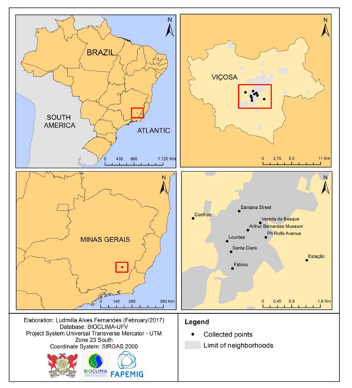
Figure 1.
Localization map of collected points in the municipality of Viçosa (MG). Data source: BIOCLIMA—UFV.
The center presents intense verticalization, a high degree of waterproofing of the soil, little or no vegetation cover, and a great flow of vehicles, especially at determined peak times. These peak times are mainly due to those who are part of the Federal University of Viçosa, since it is necessary to pass through the center to reach or return from the campus, encouraging a greater flow of people and vehicles on site. On the other hand, the peripheral districts (Barrinha, Amoras, Nova Viçosa) present a greater availability of sensible heat, due to the type of construction, and the quality and variation of the paved streets. The residential neighborhoods (Ramos, Clélia Bernardes, Fatima, and others) have also been observed, where there is a great presence of vegetation. The characteristics of a wooded space condition a smaller absorption of short waves and a more efficient emissivity of long waves, resulting in a more efficient cooling process.
Thus, the production and consumption of space results in the reworking of primitive nature, and a “new environment” is created through human action. For [11] the identification of climate change at the city level, caused by an urban/social transformation, is very difficult to identify. This is due to the fact that many towns and cities have been built in areas where the conditions that govern the climate are very complex, such as the municipality of Viçosa, in the morphoclimatic domain of the Mares de Morros [12]. Considering this, research will be conducted to gain a greater understanding of the nature and behavior of climatic elements, and their relationship with natural and human factors.
2. Materials and Methods
Nine data collection points were used in the central area of the municipality of Viçosa, whose characteristics are presented in Table 1. Each point contained an alternative meteorological miniabrigo of the PVC (Polyvinyl Chloride), as in [13], with a HOBO data logger thermohygrometer coupled in its interior. This was pre-programmed to record time. The shelters were installed following the meteorological Estação pattern, determined by the World Meteorological Organization (WMO) and highlighted by [14], at a distance of 1.50 m between the surface and the base. The data obtained is collected via a USB cable, for the HOBOware software.

Table 1.
Characterization of the surrounding collection points in Viçosa-MG.
The records analyzed are from 3–10 June 2015, during which time the Atlantic Tropical System proved to be the predominant system, according to an interpretation of the synoptic charts made available by the Directorate of Hydrology and Navigation of the Brazilian Navy). The stability conditions are ideal for the analysis of the influence of the site and urban design—anthropic factors—on the urban environment, while there is no action of phenomena that cause atmospheric instability and homogenize the local microclimates. For the analysis of the data, three shifts were defined: morning (06 h to 11 h), afternoon (12 h to 18 h), and night (19 h to 5 h, considered as dawn to sunset).
Parameters Used
At the scalar level of the microclimate, the influences of urban design on the city’s climate can be identified, measured, and analyzed in multiple ways, one of them being through the sky view factor (SVF).
According to [15] the SVF is related to the amount of visible sky, that is, the amount of sky available for the dispersion of thermal energy. The values vary between 0 and 1, where the closer a value is to 0, the greater the obstruction of the celestial vault is; and the closer a value is to 1, the smaller the obstruction is.
However, SVF values should be related to the characteristics of the site itself, since the configuration of the studied urban area has a very diverse profile. Some sites with smaller SVF values may be subjected to the influence of the shading of the higher vertical surfaces during the day, altering the expected thermal behavior. Surfaces higher than surrounding ones may be promoting the reflection of solar radiation outside the urban canyon. Therefore, this feature does not directly influence the air temperature close to the ground, hence the importance of consecutively analyzing other parameters.
The hemispherical photographs of the nine collection points were made available by BIOCLIMA—UFV, and after having been treated, they were inserted into the Rayman software for the calculation of the SVF and the insertion of the solar trajectory.
For the topoclimatic analysis, a previous detailing of the differences at the site and the use of the earth, as a support for understanding the formation of the climate and the factors causing the climatic differentiation, were derived from the diverse spatial arrangements and the society-nature interaction in the city environment. For the geographic characterization of the city, thematic maps of the hypsometry-geomorphology, slope, and slope exposure, were elaborated and analyzed through ArcMap 10.1 software. In addition, a thematic map of land use classification, elaborated within the scope of BIOCLIMA—UFV, was interpreted.
3. Results and Discussions
The position, orientation, and steepness of the slopes are attributes of relief that influence the definition of the climate [16]. Additionally, according to these authors, the position, orientation, and steepness of the slopes all influence the climatic conformation. The orientation of the slopes (Figure 2) allows the visualization of areas in which the sunshine is more or less intense, leading to an understanding of the influence of its topographic location on the conformation of the thermal field. According to the trajectory of the sun in the Southern Hemisphere, the slopes facing east receive more sunshine in the morning, and the slopes facing west receive more intense sunshine in the afternoon. The points of the Arthur Bernardes Museum and the district of Lourdes, facing north, presented higher temperatures during the period of analysis.
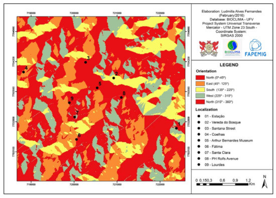
Figure 2.
Guidance map of slopes of data collection points in the municipality of Viçosa (MG). Data source: BIOCLIMA—UFV.
The corrugated surface regions have a steepness factor which modifies the surface/incident radiation [16]. The points that presented the greatest slopes (Figure 3) were those located in the neighborhood of Coelhas and Vereda do Bosque, while those with lower slopes were situated at Santana Street, the Arthur Bernardes Museum, and the neighborhood of Lourdes. Two of the points (Museum and Lourdes) that presented lower slopes, and therefore, a higher incidence of radiation, were those that also presented the highest temperatures. On the other hand, the points of the district of Coelhas and Vereda do Bosque, which presented greater slopes, and consequently, a lower direct incidence of radiation, were those where the temperatures remained mild, on most days.
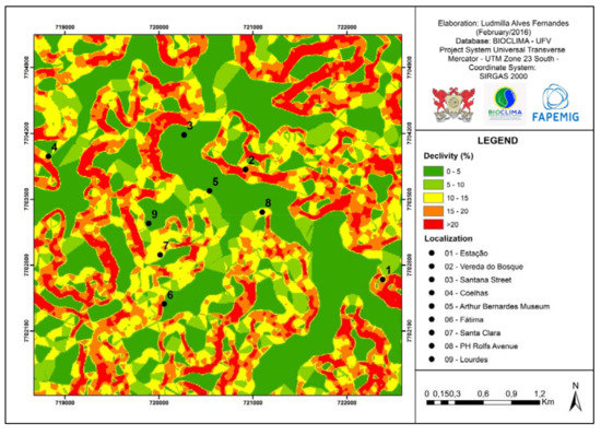
Figure 3.
Map of declivity of data points in the municipality of Viçosa (MG). Data source: BIOCLIMA—UFV Organization: Ludmilla Alves Fernandes.
The altimetric analysis showed that the difference between the points did not exceed 85 m, an amplitude that is calculated between the point of Santa Clara and Santana Street. This difference shows that the altitude did not have a great influence on the temperature data obtained, since “the vertical gradient Troposphere average is 0.6 °C/100 m” [16].
An initial analysis for the study of an urban climate requires the observation of both site topography and urban morphology models [17]. Thus, the location of the points in the urban environment itself proved to be one of the determining factors for the thermal modifications.
According to the classification of the land use, the points located in the Arthur Bernardes Museum, PH Rolfs Avenue, and Fatima, were those that presented a greater presence of built area, while the points of the districts Coelhas, Vereda do Bosque, and Estação were those that presented a higher proportion of low vegetation, forest, and grassland. This corroborates the literature which says that vegetation is a factor that softens the thermal discrepancies, as demonstrated by [18]. In addition, the influence of urban morphology can be seen in Table 2, which demonstrates the values of the SVF for each analyzed point. In addition, from the sun’s trajectory (Figure 4) at each of the collection points, it is possible to visualize from which period of the day the point receives direct solar radiation and when it stops receiving it, the time of receipt, and the shift (Table 3).
Table 2.
Sky view factor (SVF) of collection points in the municipality of Viçosa-MG.
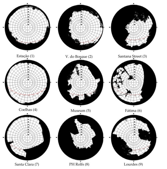
Figure 4.
Hemispherical photographs with solar trajectory of collection points in the municipality of Viçosa (MG). Source: BIOCLIMA—UFV. Organization: Ludmilla Alves Fernandes.
Table 3.
Direct radiation time at the collection points in the municipality of Viçosa-MG.
From these considerations, it is possible to analyze the thermal conformation in the three shifts of analysis. In the morning shift (Table 4), it is observed that the point of the Coelhas neighborhood is hotter than the others, while the night has lower temperatures. This situation represents the dynamics well, where rural areas heat and cool faster than urban areas. This fact can also be observed at night, when the point of Coelhas presents the loweset thermal average, demonstrating that the cooling process also happens quickly, in comparison with the other points. The PH Rolfs point, on the other hand, does not receive direct solar radiation and still has high temperatures during all shifts, which is possibly linked to anthropic conditions, taking into account the high flow of people and vehicles, especially during this shift. Finally, the spot installed in the neighborhood of Fatima, which also has high temperatures, receives direct radiation between 11 and 17 o’clock, a period in which the already-heated atmosphere conditions such values to the point.
Table 4.
Average temperature (°C) at the collection points in the municipality of Viçosa-MG in the period between 3 and10 May 2015.
In the afternoon shift, the point of the neighborhood of Lourdes also appears among the highest thermal averages, and can be explained due to the natural characteristics of the site, on which the city was built. The point is located at the end of the valley in which the central area is installed, at the half-slope. Although it presents a considerable amount of green area, the shape of the relief makes the entrance and exit of air difficult, also making it difficult to dissipate heat. On the other hand, Santana Street has the lowest thermal average. According to [19] the areas of the city with the greatest concentration of green areas, or those close to the water reservoirs, demonstrate a decline in temperature. The vegetation, in this case, acts to attenuate the thermal differences; a fact that can also be observed when comparing the averages of the points located at Estação, Santana, and Coelhas, which, in relation to the others, presented the lowest temperature values.
Finally, during the night shift, the point of the Arthur Bernardes Museum presented the highest thermal average, corroborating the hypothesis that in places where there is a higher densification of urban objects and flow of vehicles and people, this point and the one installed in Ph Rolfs Avenue, will present higher temperature values. It is worth mentioning that both points also exhibit high SVF values. The point of PH Rolfs Avenue, with a SVF of 0.311, has a horizon limitation of 68.9%; the point of the Museum Arthur Bernardes, with a SVF 0.492, has a limitation of 50.8%; and the neighborhood of Lourdes has a SVF 0.541 and a limitation of 45.9% of the celestial vault.
The point of Santana Street also presented a great limitation of the celestial vault, where 62.1% is obstructed. However, it should be considered that such an obstruction consists, for the most part, of the vegetation around the point, which softens its temperatures, and the presence of a stream near the point. On the other hand, the Estação point, which presented the lowest thermal averages, was the point at which the SVF index was higher and the horizon limitation was lower.
4. Final Considerations
In view of the presented results, it was noticed that the factors influencing the thermal field conformation have mutual relations.
The points located in places where the urban morphology is characterized by open and natural areas, were those where the celestial obstruction was smaller, facilitating the processes of absorption and heat emission; that is, the heat exchange between the surface and the atmosphere. These points presented the lowest averages in the analysis period, and the inverse was observed for those where there was a greater obstruction of the celestial vault.
The urban geometry and use/land cover have been shown to be elements of great weight in the thermal configuration. Also, it was proved that the vegetation was a factor that softens the temperature. In contrast, in the local points where there is a greater density of urban objects and flow of vehicles and people, the averages presented were high, compared with the others.
The thermal differences between the three shifts were linked, in most analyzes, to the gynecological and/or anthropic conditions. This fact allows us to affirm that the urban climate of the municipality of Viçosa is conditioned to two opposing factors, that act together to form the thermal field.
It is of utmost importance, therefore, to think about the configuration of the urban thermal field as a result of a set of variables that are interrelated, so that the complex urban thermal environment becomes such through these relations.
Acknowledgments
To all fellows and volunteer members of the Laboratory of Biogeography and Climatology (BIOCLIMA-UFV) Robson Rodrigues Quina, Gabriela Regina Ferreira, Edilson Junior Celestino, Maria Luzia Silva Paulo, Fernanda Evelin de Castro, and Vinicius Diogo Santos, who assisted in the development of the work. To the National Council of Scientific and Technological Development, CNPq for financing the project “An evaluation of the transformation of an urban landscape and its influence on the thermal field: A case study in Viçosa-MG.” CNPq Universal Announcement process number: 441819/2014-1 in which the work is derived.
Author Contributions
This manuscript is result of the research project conducted by Ludmilla Alves Fernandes (L.A.F.) as part of her scientific initiation financed by the Foundation for Support of Research of Minas Gerais (FAPEMIG) and developed at de Laboratory of Biogeography and Climatology of Federal University of Viçosa (UFV). Edson Soares Fialho (E.S.F.) and Leonardo Brandão do Padro (L.B.d.P.) worked together. The work was conducted under the guidance of E.S.F. and L.B.d.P. provided assistance in the analyses. The manuscript was prepared by L.A.F. and L.B.d.P. with E.S.F. suggestions. All authors read and approve the final version.
Conflicts of Interest
The authors declare no conflict of interest.
References
- Santos, M. A Urbanização Desigual; Vozes: Petrópolis, Brazil, 1980. (In Portuguese) [Google Scholar]
- Fialho, E.S. Ilha de Calor em Cidade de Pequeno Porte: Caso de Viçosa, na Zona da Mata Mineira. 259f; Tese (Geografia Física) Faculdade de Filosofia, Ciência, Letras e Ciências Humanas, USP: São Paulo, Brazil, 2009; Available online: http://www.teses.usp.br/teses/disponiveis/8/8135/tde-22022010-154045/pt-br.php (accessed on 3 October 2016). (In Portuguese)
- Fialho, E.S.; Quina, R.R.; de Souza Alves, R.; Miranda, J.D. O campo térmico em situação sazonal de verão, no município de Viçosa-MG. Geografias (UFMG) 2015, 1, 80–98. Available online: http://www.igc.ufmg.br/portaldeperiodicos/index.php/geografias/article/view/640 (accessed on 7 November 2016). (In Portuguese).
- Fernandes, L.A. Ambientes Urbanos e Fatores naturais na conformação das condições climáticas no período do Inverno em Viçosa/MG. Rev. Ciênc. Hum. Viçosa 2015, 15, 366–380. Available online: http://www.cch.ufv.br/revista/pdfs/vol15/artigo5dvol15-2.pdf (accessed on 11 December 2016). (In Portuguese).
- Fialho, E.S. As repercussões da expansão da mancha urbana na dinâmica climática local de Viçosa-MG. Rev. Ciênc. Hum. Viçosa 2015, 15, 301–323. Available online: http://www.cch.ufv.br/revista/pdfs/vol15/artigo1dvol15-2.pdf (accessed on 21 November 2016). (In Portuguese).
- Quina, R.R. Influência de sistemas sinóticos na diferença térmica entre campo e cidade, estudo de caso de Viçosa-MG. Rev. Ciênc. Hum. Viçosa 2015, 15, 324–337. Available online: http://www.cch.ufv.br/revista/pdfs/vol15/artigo2dvol15-2.pdf (accessed on 15 September 2016). (In Portuguese).
- Ferreira, G.R.; Fialho, E.S. Campo térmico x fator de visão do céu: Estudo da área central do município de Viçosa-MG em Episódios de outono e inverno/2014. Boletim Gaúcho de Geografia 2016, 43, 247–271. (In Portuguese) [Google Scholar]
- Fernandes, L.F.; Fialho, E.S. A relação entre os aspectos geoecológicos e antrópicos para a conformação do clima urbano: estudo de caso no municipio de Viçosa-MG no ano de 2015. In Proceedings of the Annals 4th Colloquium Ibero American Cultural Landscape, Patrimony and Project, Belo Horizonte, Brazil, 26–28 September 2016; Available online: http://www.forumpatrimonio.com.br/paisagem2016/trabalho/368/a-relacao-entre-os-aspectos-geoecologicos-e-antropicos-para-a-conformacao-do-clima-urbano-estudo-de-caso-no-municipio-de-vicosa-mg-no-ano-de-2015 (accessed on 27 October 2016). (In Portuguese).
- Fernandes, L.F.; Fialho, E.S. A relação entre os aspectos geoecológicos e antrópicos para a conformação do clima urbano de Viçosa-MG em situação sinótica de estabilidade em 2015. In Proceedings of the Annals 12th Brazilian Symposium on Geographical Climatology, Goiânia, Brazil, 25–29 October 2016; Available online: http://www.abclima.ggf.br/anais/12SBCG.rar (accessed on 2 December 2016). (In Portuguese).
- Ribeiro Filho, G.B. A Formação do Espaço Construído: Cidade e Legislação Urbanística em Viçosa, MG. Master Thesis, Faculdade de Arquitetura e Urbanismo, Universidade Federal do Rio de Janeiro, Rio de Janeiro, Brazil, 1997. (In Portuguese). [Google Scholar]
- Landsberg, H.E. O clima das cidades. Revista do Departamento de Geografia 2006, 18, 95–111. Available online: http://www.revistas.usp.br/rdg/article/view/47269/51005 (accessed on 5 November 2016).
- Ab’saber, A.N. Os Domínios da Natureza no Brasil: Potencialidades Paisagísticas; Ateliê Editorial: São Paulo, Brazil, 2003. (In Portuguese) [Google Scholar]
- Alves, R.S. Interações Entre Fatores e Elementos do Clima no Percurso Ponte Nova—Viçosa—Ubá, Zona da Mata Mineira: Identificação de Diferentes Ambientes Termohigrométricos. Monograph, Universidade Federal de Viçosa: Viçosa, Brazil, 2015. Available online: http://www.geo.ufv.br/wp-content/uploads/2015/12/Rafael-de-Souza-Alves.pdf (accessed on 18 November 2016). (In Portuguese).
- Varejão-Silva, M.A. Meteorologia e Climatologia, Versão Digital 2; Instituto Nacional de Meteorologia (INMET): Recife, Brazil, 2006. (In Portuguese) [Google Scholar]
- Minella, F.C.O.; Rossi, F.A.; Kruger, E.L. Análise do efeito diurno do fator de visão do céu no microclima e nos níveis de conforto térmico em ruas de pedestres em Curitiba. Ambiente Construído 2011, 11, 123–143. Available online: http://www.scielo.br/scielo.php?pid=S1678-86212011000100009&script=sci_abstract&tlng=pt (accessed on 15 November 2016). (In Portuguese). [CrossRef]
- Mendonça, F.; Danni-Oliveira, I.M. Climatologia: Noções Básicas e Climas do Brasil; Oficina de Textos: São Paulo, Brazil, 2007. (In Portuguese) [Google Scholar]
- Mascaró, L.R. Ambiência Urbana; Sagra-D.C. Luzzatto: Porto Alegre, Brazil, 1996. (In Portuguese) [Google Scholar]
- Teixeira, P.H.L.; Lucas, T.P.B. A Influência da Vegetação em um Microclima da Cidade de Belo Horizonte, MG; Caderno de Geografia: Belo Horizonte, Brazil, 2014; Available online: http://periodicos.pucminas.br/index.php/geografia/article/view/6623 (accessed on 22 September 2016). (In Portuguese)
- Amorim, M.C.; Neto, J.L.; (org). Climatologia Urbana e Regional: Questões Teóricas e Estudos de Caso; Outras Expressões: São Paulo, Brazil, 2013. (In Portuguese) [Google Scholar]
© 2017 by the authors. Licensee MDPI, Basel, Switzerland. This article is an open access article distributed under the terms and conditions of the Creative Commons Attribution (CC BY) license (http://creativecommons.org/licenses/by/4.0/).