Abstract
Sensors and intelligent applications enabling smart vehicular traffic create an opportunity for improving the welfare of people, from the viewpoints of efficiency, sustainability, and social inclusivity. Like the opportunities, challenges of such an endeavour are multifaceted, including the scalable collection and processing of the hefty data volumes generated by sensors, and the coordinated operation between selfish agents. The purpose of this work is to survey recent literature with an emphasis on applications and a multidisciplinary eye, with the aim of stimulating discussion and reflection in the scientific communities. The principal application areas of smart traffic and smart mobility are discussed, synthesizing different perspectives. Many intriguing areas for future research exist besides those relative to connectivity, data fusion, and privacy. Some research challenges pertinent to sustainability, insurance, simulation and the handling of ambiguous information are highlighted.
1. Introduction
Computer scientists consider that we have entered the Centaur Era (humans and computers working together). People are interacting with the physical world in completely new ways, with sensory input devices, smartphones, wearables, smart applications, cars, robots and computers augmenting reality to assist humans [1]. A rich variety of sensors are present in almost all smart phones: accelerometers, gyroscope, magnetometer, GPS technology, barometer, proximity sensor, ambient light sensor, sound sensor (microphone), touchscreen sensors, fingerprint sensor, pedometer, barcode/QR code sensors, heart rate sensor, thermometer, air humidity sensor and even Geiger counter which can measure the radiation level. The utility of sensors is ubiquitous: starting with embedded systems dedicated to air and water quality monitoring [2], wearable sensors for remote health monitoring [3], to wireless sensors networks used in smart transportation system (e.g., bus management routes) [4], continuing with cars microcontrollers and its ecosystem of sensors used both for critical safety systems—engine, brakes, steering and suspension control—and for non-critical functions dedicated for automatic navigation, indoor air conditioning, central door locking, and entertainment devices. No matter where are applied, sensors provide input data for application processing, their common purpose being to improve life quality. Sensors can allow contextual sensing and understanding: e.g., automatic people gender detection by walking patterns, or mood detection based on different types of movements (slow, nervous or excited), activity detection (walking, running, sitting), automatic detection of the context (inside or outside), or detecting movement intensity based on heart rate and oxygen levels, also providing health status information. The advances in electronics, nanotechnology and biomedical sciences have allowed sensors to be used in monitoring applications of different targets at spatial and temporal resolutions that have never been possible so far providing big datasets.
The explosive increase in the number of sensors and applications in new cars has prompted a change in the role of vehicles, from a peripheral one—strictly for transport—to a real network that hosts clusters of connected devices. Millions of sensors used by people and their mobile devices enhance the advanced infrastructure, intelligent networks and platforms of smart cities [5]. Smart public transport uses the technology to provide public transport users with a better user experience. The use of sensors and the GPS technology can provide real-time data about geospatial location of each bus, next-stop information relative to current location, and delay information relative to default timetables, about arrivals and departures of public transport. Online route planners which are able to provide much more useful information beside the travelled distance and crowded zones—such as air quality, road profile, and profit that might be obtained on each route—may help users choose the most efficient route from one location to another.
Devices and sensors communicate with each other like never before—more frequently, gathering more data—which in turn makes the communication more significant. Daily, more sensors are going online, increasing the wealth of useful information. Thousands of sensors are located on the highways and main streets collecting traffic parameters—occupancy, volume, and speed—at the rate of one reading per sensor per minute. Smart street lighting is based on enhancing lamp posts with sensors for detecting traffic—cars or pedestrians which are approaching—so that light intensity can be increased when it is actually needed. With this addition, lamp posts become smart assets that will help monitoring everything from the weather and air quality to traffic, even detecting and assisting police in locating gunshots or contributing to reduce the number of burglaries or crimes.
Accuracy, completeness, and timeliness of information, together with the speed of decision-making are of paramount importance in managing the mobility of goods and people. Smart traffic and the associated sensor networks are subjects that have recently attracted—and chances are they will continue to attract—a significant deal of research recently. A search in the Scopus database reveals that from 2010 until now more than 589,719 documents related to sensors in general appear on Scopus, and more than one thousand papers dealing with smart traffic have appeared in the last two years. Although several reviews have been published, none examines the research on smart traffic from the point of view of applications, adopting a multidisciplinary stance. This survey aims at filing that gap. Recent literature is critically reviewed and an interdisciplinary synthesis, which has been seen to be advantageous [6] is provided. Some significant trends and challenges for future research are highlighted and discussed.
The need for a multidisciplinary approach to smart traffic also results from Figure 1, which displays commonly found keywords and the relationship among them in terms of co-occurrence in scientific literature. The VOSviewer (http://www.vosviewer.com) software determines how often each keyword occurred within the database as well as how often the elements were cited together. A systematic survey analyzing bibliographic data can be found in [7]. Clusters are shown on the map in different colours. Basically, six clusters of terms can be isolated, counting 77 words all together, and three of these clusters are more significant in the context of this work. The first cluster is composed of terms related to the prediction, modeling and deployment of infrastructure that enables smart traffic—wireless networks, smart grids, VANETs, LTE networks—as well as performance analysis metrics, energy efficiency, load balancing. The second cluster is centred around the smart city concept and includes intelligent transport, autonomous vehicles, electric vehicles, smart card, smart devices, cyber–physical systems. The third cluster is organized around solution for the avoidance of traffic congestion: use of mobile phones, video analysis and image processing applications, RFID, user participation, and driver history-based applications. The other clusters are organized around the much broader concept of Internet of Things (IoT), Web, or challenges such as privacy and security of data collected from modern vehicles and hardware and software applications opportunities.
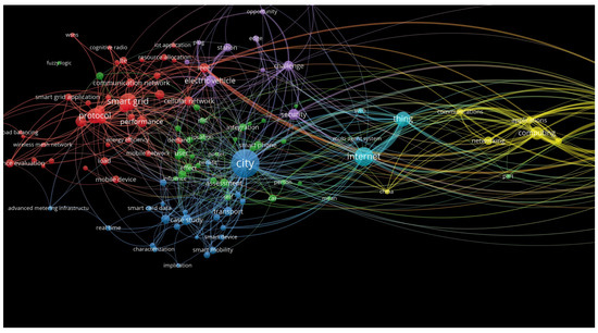
Figure 1.
Map of current research trends based on the co-occurrence of keywords in Scopus database for the years 2016–2019. The size of the point and font representing each term show the frequency with which this key word occurs. Source: authors’ own study using VOSviewer software.
In the next section, a wide perspective on smart traffic is presented. Section 3 is then dedicated to aspects concerning the gathering, fusion and transmission of information. A discussion of the principal application areas is the focus of Section 4, while Section 5 discusses themes that constitute auspicious avenues for further study. Section 6 concludes the paper.
2. Smart Traffic
We are increasingly becoming digital citizens. However, it is implicit even in the term “citizen” that cities and urban areas are our main ecosystem.
Smart traffic and the intelligent applications associated with it represent an opportunity to optimize resources, encourage sustainable practices, fight inequalities, create new opportunities, and, generally, improve the welfare of people, paving the way for an efficient, technologically advanced, green and socially inclusive city [8]. The challenges of such an endeavour are multifaceted in the same way, and they include transforming the huge volumes of data generated by sensors and citizens into useful information, deploying and managing limited resources, realizing scalable solutions able to support millions of users, stimulate cooperation and coordination between selfish agents, and effectively communications with citizens with diverse conditions, interests, motivations, and culture.
When the humongous amount of data produced by vehicular traffic is profitably analysed and used, both government and residents will reap the benefits. Traffic information and forecasts will help residents better plan their journeys, while authorities can discipline traffic, effectively deploy officers, and also monitor environmental parameters with the help of air quality and acoustic sensors [9]. Good traffic estimates can be beneficial for many tasks, such as trip planning, traffic management, road engineering, and planning the construction of new roads [10]. The benefits associated with less congestion and with a real-time knowledge of alternative, less crowded roads also relate to the financial advantages of optimized deliveries and improved shipping movements [11]. A better flow of traffic is beneficial to public health, with reduced emission of pollutants, and it also alleviates problems related to equity, with respect to the fraction of citizens who do not have access to a car, yet have to bear the consequences (physiological and financial) of car traffic.
Management allows governments, organizations, and decision-makers to make their projects and services more efficient, and coherent with the needs of citizens and customers. The objectives of municipal authorities when embracing smart traffic projects can be various. Some approaches prioritize the anticipation and mitigation emergency situations over an analysis of normal traffic. An example is the city of Rio de Janeiro, which is now equipped with a citywide Emergency Response System [12]. Besides allowing priority mechanisms for emergency vehicles like ambulances and fire trucks, thus improving the response to accidents and crises, authorities can also gain actionable insights by looking at details of past road mishaps. Knowing the circumstances under which an accident occurred and the speed of the vehicles involved can help reduce the number of accidents. A detailed monitoring of the roads can also be helpful in detecting stolen vehicles. A related area of interest is the increasing willingness of city authorities to incentivize usage of public transportation instead of private cars. Traffic lights may adapt their behaviour in accordance with the presence or absence of public transport vehicles. The home-office commute is an ideal target in this pursuit, keeping into account that in this context cars remain parked 95% of the time [13].
2.1. Utopian Visions and Critiques
Infrastructures are critical elements for the everyday lives of people. Endowing infrastructures with sensors and actuators capable of collecting information and act adaptively and timely has a tremendous potential of accommodating the needs, demands, and desires of citizens. In the words of Kitchin, it would be possile to “optimize resources, plan preventive maintenance activities, and monitor security aspects while maximizing services to citizens” [14]. Townsend goes to greater lengths, affirming that we are facing “an historic shift in how we build and manage cities”, comparable to the “laying of water mains, sewage pipes, subway tracks, telephone lines, and electrical cables” [15]. However, risks exist, as pointed out in a provocative essay by Greenfield [16], who argued that the corporate-driven utopian vision of smart city is too narrow, centred only on the technological perspective, and it can be detrimental and promote, instead, an undesirable vision of future cites with centralized computational surveillance and control, servicing primarily those in power. Specifically focusing on sensors, Greenfield also underlines that beyond possible malfunctions in operation or improper deployment, measurement of a complex system such as a city is surely going to modify it. Finally, Greenfield warns about the use of easily-measured values as proxies for a reality so complex that it seems to escape attempts at quantification. Regarding data as “transcendent, limpid and uncompromised by human frailty” crystals of perfect knowledge ignores choices made in designing, implementing, and deploying sensors, as well as conscious or unconscious attempts at obfuscation performed by those who are subject to observation or measurement [16].
Aspects related to privacy, security and control constitute one of the most diffused fears about smart mobility, especially when citizens become active sensing nodes, or citizen-sensors. In a vision where data coming from traffic sensors is to be integrated with information gathered from smartphones, and the latter also includes human-generated feedback, the underlying assumption is that citizens own a smartphone or even a self-driven one, are digitally educated, and aware of their role [17]. In this rather homogeneous view, there is little room for minorities characterized by different social positioning and cultural habits. In some areas, most people have no access to a car, let alone a smart one [18]. Less extremely, traffic information should be quickly, effectively, and accurately delivered to drivers, via smartphones or other communication devices. It is conceivable that vendors try to gain a competitive advantage by providing their customers with more timely, relevant, an precise information, widening the gap between those who have access to their solutions and those who do not. While competition among vendors drives technological improvement, public safety should be protected by defining minimum standards of information quality that should be available to everyone.
The breadth of the “smart” in the notion in smart traffic was also pinpointed by Aguilera et al. [19], who defined a smart city as a “very broad concept, which includes not only physical infrastructure but also human and social factors”. The concept of smart city is also connected to the notions of smart buildings [20]. A rapid technological advancement provokes the insurgence of a push to continually release new products into the market, with a fierce competition among technology vendors—and consultancies, too—to secure a niche in a rich and expanding business. Particularly in times of recession, this push can represent an essential opportunity for growth for ICT companies [21]. As the push is solely based on supply, it contrast with the demand pull, i.e., the solutions researched, devised, and commercialized as a response to needs eplicitly expressed by society [12]. The two impulses should, as far as possible, reconciled. One effort in this direction is the definition of smart urban mobility as “connectivity in towns and cities that is affordable, effective, attractive and sustainable” offered by Lyons [22].
2.2. Smart Traffic Lights
Smart traffic lights enable a good degree of control of traffic flows within a city or area. This will enhance commutes, reduce congestion, and improve transport systems. Smart traffic lights and signals are important tiles in the overall picture. Usually, in large cities traffic is controlled by traffic lights that use timers while in the suburbs, small towns and county roads, traffic signal sensors are preferred because they not only manage the unsteady traffic flow effectively, but also detect when cars arrive at intersections, when several cars are stacked at an intersection and when cars have entered turn lanes. Smart traffic lights might be triggered by sensors of different technologies like microwave radar, cameras, induction loops, or lasers that detect motion. Smart traffic lights can switch the light signal depending on the workload of the roads, thus eliminating needless delays at intersections where load is unevenly distributed across the roads. Another switching parameter of the traffic light can be the measured level of pollutants—carbon dioxide, nitrogen dioxide, particulate matter—thus improving air quality [23]. More than a quarter of CO emissions are due to transportation, and road transport contributes around 65% of it [24].
The chart in Figure 2 is based on information from the European Automobile Manufacturers’ Association (ACEA) and the International Monetary Fund (IMF). It depicts the number of passenger cars from each European country versus the gross domestic product per capita (GDP). Almost all points lie in the upper left part of the chart, showing a trend to own more cars in proportion to what could be expected in proportion to the GDP. The total number of vehicles in use in the European Union grew by over 6.28% between 2012 and 2016, and by more than 2.1% from 2015 to 2016 [25]. The global number of cars on the roads is estimated to nearly double by 2040 [26]. Table 1, compiled with data from ACEA, the International Organization of Motor Vehicle Manufacturers (OICA, http://www.oica.net/category/vehicles-in-use/), and [26], contains the overall number of vehicles, including passenger cars, trucks, and buses, in Europe and all over the world.
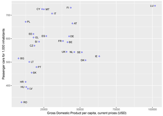
Figure 2.
Scatter plot of the number of passenger cars per 1000 inhabitants versus the gross domestic product per capita, (current prices, in U.S. dollars) for European countries identified by their two-digit code. Data as of 2016. Source: authors’ own study on data from ACEA and IMF.

Table 1.
Vehicles in use (in millions) in Europe and worldwide. Source: ACEA, OICA, and [26].
Using the Greenhouse Gas Equivalencies Calculator https://www.epa.gov/energy/greenhouse-gas-equivalencies-calculator from the U.S. Environmental Protection Agency, the emissions produced yearly by vehicles from entire world for the years 2015, 2025 and 2040 could be converted for comparison in other units, such as the annual emissions by households. The pollution produced by cars is equivalent to the yearly energy consumed by 620.4 million houses (2015), 846 million houses (2025) and 1128 million houses (2040). All the above data highlight the danger created by emissions and the necessity to devise smart solutions for traffic congestion.
Provided that air quality measurements of high granularity are available, focused restrictions for local situations can be envisaged—e.g., forbid road traffic only in a specific area instead of the whole city center. In addition, if drivers could be notified dynamically about restrictions—via an app, but ideally through direct communication with the onboard GPS navigator—vehicular flow could be acted upon not only based on traffic conditions but also on environmental variables [27].
Interconnected across a city, sensors detect different parameters relative to the traffic flow, for example waiting time at the lights, density, or speed. Based on the readings, a system can make informed decisions and instruct the traffic lights and signals appropriately. Given that the more data are available to such a system, the more complete and integrated view it will have, it would be preferable to collect data from all traffic lights across the city, requiring the use of big data analytics [11]. Real-time data are useful to calibrate models to predict traffic patterns. In fact, random variations in traffic due to the stochastic variability are not reflected in one-day traffic counts. The effectiveness and potential of decentralised, adaptive traffic signal control systems has been proved by a pilot implementation for a nine-intersection road network in Pittsburgh, Pennsylvania (USA) [28].
2.3. Intelligent Transportation Systems
An Intelligent Transportation System (ITS) is able to improve the efficiency and safety of transportation, at the same time lightening the environmental impact [29]. ITS, comprehensive systems augmenting conventional transportation infrastructures with technology, are believed to have a great potential in transportation management [30]. ITS are cyber–physical systems (CPS), with a high level of integration between the cyber components and the physical components. The cyber part consists of communication, information collection, control mode, collaborative algorithms, whereas the physical part includes different kinds of sensors, basic infrastructures, and on-board computers and controllers. A multimodal ITS can integrate data from cellular networks and GPS probes to estimate vehicle speed, space occupancy, and congestion [31]. A smart traffic infrastructure can also support autonomous and semiautonomous vehicles, whose predictive trajectory guidance systems must be able to withstand dynamic environments [32]. Visible light communication technology can also be the basis for an ITS, as shown in [33].
In an ITS , the control strategy to alleviate traffic congestion is essential. Huang et al. presented a specific policy, with simulations results showing its effectiveness [34]. An ITS can be used to support the planning for urban evacuation under emergency conditions, also providing the basis to a quantify risk reduction in the transportation system [35]. It was pointed out that the information trasnferred in ITS may be used to extract individual moving preferences, violating privacy, but this aspect has been seldom taken into consideration by designers of the CPS for ITS [36].
In 2016, the British research firm Juniper Research established a hierarchy regarding smart cities in the world starting from different criteria like adoption of smart grid technologies, intelligent lighting, using of intelligent tools to improve traffic, Wi-Fi access points, smartphone penetration, and the app landscape for smarter travel (https://www.iotworldtoday.com/2016/05/18/world-s-5-smartest-cities/). Table 2 summarizes some points.
Table 2.
Features related to smart traffic in the top five smart cities in the world (data as of 2016).
3. Infrastructural Considerations
3.1. Connectivity
Connectivity to the Internet for all vehicles on a road can be achieved by coupling onboard systems with the smartphone of the driver. With this mechanism, actively pursued by Apple and Google, drivers are also uniquely identified by means of their phone number [23].
A weak spot of cognitive traffic management system (CTMS) is the absence of a single communication standard for M2M connectivity [23]. Heterogeneous wireless networks should be built, with devices operating under different standards and in different frequency ranges among which: ZigBee, 6LoWPAN, WiFi, 3G, 4G, 5G, and Bluetooth. Each of these network type has its own merits and shortcomings, as far as bandwidth, range, and power consumption are concerned. The relative priority of these factors is not always the same in all settings, so none of the listed communication technologies is preferable to the others for all applications. The 6th generation of communication networks, its services and break-through technologies are a subject of active research.
Most works focus on the sensing and delivery networks, and the list of open research challenges is extensive [37], including scalability issues, fault tolerance, spectral efficiency, network delay, and real-time control and reconfiguration, including smooth and agile management, routing, addressing, and access control.
3.2. Social Networks
Vehicular Social Networks can be a promising tool to describe and analyze smart mobility [38]. Wu established an ITS with a network security mechanism in an Internet of Vehicles (IoV) environment [39]. The communication architecture of IoV includes vehicles, Road Side Units (RSU), and other devices. The heterogeneous architecture of IoV is divided into five layers: data acquisition layer, communication layer, data processing layer, application layer, and security layer [40]. Vehicular communications in IoV can be classified in different modes, namely Vehicle to Vehicle (V2V), Vehicle to Pedestrian (V2P), Vehicle to Infrastructure (V2I), Vehicle to Sensor (V2S), and Vehicle to Roadside (V2R). Data gathered from various sources can be collected through vehicular sensor networks, building a knowledge-based ITS [41]. A comprehensive review of research on the Social Internet of Vehicles (SIoV), a network that enables social interactions both among vehicles and among drivers, has been presented by Maglaras et al. [42].
3.3. Multiple Sensors
Traditional traffic monitoring is based on static sensors, such as inductive loop detectors and video cameras with the associated identification software, usually deployed at roadside or at intersections to detect traffic velocity and density [43]. Deployment and maintenance cost limit the coverage of these solutions [44], since installing loop detectors and video cameras so densely as to cover the entire road network is impractical. Table 3 recaps the advantages and disadvantages of a direct sensing method in comparison to indirect traffic sensing based on video cameras. A detailed survey on this theme can be found in [45]. The widespread availability of GPS receivers embedded in vehicles and smartphones makes them natural candidates for monitoring traffic [46].
Table 3.
Comparison between video-based detection and inductive-loop based direct sensing.
Additional sources of sensing data are of interest. By consolidating readings from various sensors and networks on a common spatiotemporal basis, potential hidden associations and relationships among the phenomena measured and different variables may be unveiled. Contextual information relevant to smart mobility can be considered at different scales [47]. On a small scale, data related to individuals or their immediate surroundings are taken into account. On an intermediate scale, the data source are neighbourhoods or communities, while on large scale population-wide interactions are considered. A taxonomy similar to the previous one but orthogonal to it applies to the time scale of contextual information which can be related to short, medium, or long-term interactions.
Traffic information should be collected through a plurality of sensors—ideally almost every smart device with the ability to make and transmit measurements—fusing their readings into a coherent whole. This will simplify the task of distinguish between a vehicle that is waiting at a traffic light on an uncongested street and a vehicle that is blocked in a traffic jam. The technical challenges of joining and integrating data streams coming from smart traffic lights and on-vehicle devices are related with interoperability, scalability, infrastructure management, data privacy and security.
Scalable solutions are needed for the massive deployment of all types of sensors and actuators, for the actualization of reliable and efficient Machine-to-Machine (M2M) communications infrastructures, and for processing the huge amount of gathered data to provide value-added services and applications. M2M networks are fundamental components of smart-mobility communication ecosystems. A priority-based M2M overlay network over LTE for smart-city services, designed to allow a huge number of M2M devices to coexist with Human-to-Human (H2H) communications is presented in [48]. Multiple priority classes are supported in the M2M packets flowing through the network, and bypassing the full LTE handshake procedure for gaining access to the network is possible. When the intensity of H2H interchange is known in advance (or can be reliably estimated), the trade-offs required to meet performance and reliability targets for M2M communications can be determined.
While some attempts at integration has been done in the context of environmental monitoring, involving sensors for temperature, relative humidity, dew point, gas, wind, rain, and atmospheric pressure [49,50], the benefits of integration extend to traffic monitoring, where sensor readings are complemented with contextual data. Traffic monitoring is conducted by sensing capabilities, the GPS receivers installed on modern vehicles and a mixture of air quality sensor and acoustic sensors along the given road [51].
Low-cost sensors enable the collection of crowd-sourced data sets that carry relevant information about traffic flows and population exposure to air pollution. Multifunctional hardware modules can, for example, be developed and placed on cars to gather data both when the car is in motion and when it is parked [52]. One of the challenges of crowd-sourced data is the extent to which they are representative of the entire population. The effects induced by the uneven distribution of sites visited by citizens who provide data should be identified and isolated. A thorough statistical analysis of intra-site and inter-sites variability is needed in order to ascertain whether and how some explanatory factors are related to large intra-site differences [53]. Low-cost air-quality sensors can be combined with more expensive monitoring stations to increase the granularity of the measurements. In such settings, issues of reliability become of paramount importance. Low-cost sensors may be not well calibrated, so their readings should be taken with care. Any embedded system which collects data through sensors especially in environmental monitoring [2] should comply with the Quality Assurance mechanism for sensors. This supposes continuous monitoring of the following parameters, metrics or stages development: precision, frequency, duration, sensor expiration or damage, interferences (with heat/cold), response to loss of power, detection limit and response time, accuracy of timestamp, which is the uptime of the sensor, concentration range. However, the measurements taken by the expensive air quality monitoring stations can be used to dynamically calibrate the low-cost sensors [54]. Intentional manipulation of sensor data is an issue clearly requiring attention, because an attacker who managed to control a significant number of low-cost sensors could provoke chaotic situations. Coherence of the readings with those of sensors in the vicinity can alleviate the problem, but high standards of security remain strongly advisable.
An added value of fine-grained people flow monitoring is that it enables new public safety services. Areas with unusual concentration of people can be identified, comparing the number of detected devices with capacity thresholds, or even searching for people inside buildings in case of natural disasters such as fire or earthquakes [54].
4. Principal Applications
4.1. Freight and Public Transit
Transportation encompasses [55] distribution of goods, movement of people, and the provision of services such as waste collection. Smart freight is concerned with enhancing the movement of vehicles that carry goods into, out of and within urban areas. People transit includes individual and collective transport. The latter provides public mobility services, through planned by service providers, as opposed to individual transport where routes are determined by personal choice. While servicing all areas is important in some context, the efficiency of public transit depends on the economies of scale achievable by transporting a large number of passengers. Cities are affected by large movements of freight, since production and consumption is largely concentrated in cities [56]. Current distribution practices characterized by little inventories and timely deliveries, coupled with the significant volume of personal deliveries resulting from business-to-consumer electronic commerce leads to anticipate that the number of freight vehicles within city boundaries is expected to continue to grow.
Freight and people transit are often analysed separately. However, passengers and freight movements influence each other, because they sometimes operate concurrently on the same road infrastructure [28]. Models considering both public transit and freight would thus, be preferable. In addition, the emphasis is mainly laid on technology aspects, with limited attention on value creation [28]. An exception is the work by Gevaers, Van de Voorde, and Vanelslander [57], who developed a simulation tool to study the main drivers influencing B2C (Business to Consumer) last mile delivery costs, including consumer service level, the type of delivery, the market density, the type of delivery vehicles, the adoption of ITS. Luong et al. [58] surveyed a wide range of economic and pricing models for data collection and communication in an IoT system, mainly focusing on the sensing network. To estimate the benefits achievable through Automatic Vehicle Location Systems, Cheng and Li [59] presented a simulation model based on Fuzzy Neural Networks.
A description of public transit include data that applies to general traffic, such as real-time sensor data related to vehicle positioning, social network data associated with events, as well as specific data such as static data corresponding to transit schedule and routes. Having supplementary data available opens additional opportunities for context sensing, but aggregation of data brings forward issues of quality and credibility [60].
Smart waste management systems involve the introduction of policies for sustainability and community health at the municipal and governmental levels. The authors of [61] present a smart waste-management system that uses WSNs to monitor accumulated waste levels in garbage bins within a municipal region. An heuristic algorithm determines the number of trucks, route per truck, and the order of collection per bin in order to minimize the delay, and the cost of garbage collection (in terms of both mileage cost and pollution penalties).
4.2. Taxi
Informed driving is increasingly becoming a key factor for the sustainability of taxi companies. A short-term forecast of the spatial distribution of taxi passengers by means of time series analysis methods is described in [62]. The updates from probe vehicles (e.g., taxis) equipped with low-cost GPS receivers, periodically sending their instant location and speed to a management centre, can be used to estimate traffic on a metropolitan scale. However, data from even a relatively large number of probe vehicles can contain spatiotemporal sampling vacancies [10], because radio signal can suffer attenuation and the movements of probe vehicle is uneven. Compressive sensing and principal component analysis (PCA) reveals the structure hidden in observations [10].
Taxi GPS traces have also been analysed in conjunction with the revenue flows of inividual taxi drives [63], to derive information about the effectiveness of strategic choices drivers make when servicing passengers, when cruising along the roads searching fo passengers, and when choosing specific areas of operation.
When a vehicle can be used by more than one driver (such as, e.g., in delivery fleets), the unique driving habits of each driver influence vehicle behaviour. An In-Vehicle Data Recorder (IVDR) is a system that registers vehicle movements and the actions of the driver. Early usage of IVDR systems was targeted towards tracking of vehicle location and providing evidence in case of accidents. Several researchers developed algorithms that detect abnormal driving behaviours based on IVDR systems for automotive control applications [64]. Differences in driving style reported by IVDR systems can also be used for identifying individual drivers of shared veicles based on historical journey data [27]. The authors emphasize that their approach is independent from sophisticated models of traffic, which were at the foundation of previous work [65].
Taxi traces can also be used to characterize the dynamics of flow associated with social events on a metropolitan scale [66]. Taxi trip data have high spatiotemporal resolution and are suitable for extracting urban events with high accuracy. Being associated with an unusually large number of participants, social events are accompanied by observable variations in traffic flow. Additionally, people tend to gather slowly before an event, and depart in a more synchronous manner after the event. This impacts on traffic and raises problems of public security, because a quick and secure evacuation is needed.
4.3. Smart Parking
Smart parking is an important application related to smart traffic. The time spent by drivers searching for a free parking spot not only represents a waste of time and fuel in itself. Its effects are amplified by the additional traffic congestion that it provokes, which in turn amounts to supplemental waste for other drivers. By aggregating sensors into self-organizing WSNs, assistance to drivers can be provided, effectively searching for available parking spots nearby, while at the same time saving energy and prolonging the battery lifetime of sensors [67]. With smart parking, arriving and departing times of different cars are traced all over the city. Thus, parking lots can be planned so as to take the potential number of vehicles to be serviced into account. Accordingly, the data of smart parking provide profits for both customers and merchants.
Management of indoor parking areas is simplified somewhat, give that multiple systems enable the collection of data about the status of parking spots. One issue in smart parking is how to reliably and efficiently detect vehicles entering or exiting a parking lot. Solutions such as inductive loops, RFID-based systems, and video image processors carry high installation and maintenance costs. Therefore, ultrasonic sensors have been proposed [68,69].
5. Challenging Aspects
5.1. Insurance
Insights gained from monitoring allow diminishing the occurrence of risky behaviours by providing feedback to drivers or to their supervisors (e.g. parents, fleet managers) [70]. In case of connected cars, combining mobile communication and satellite positioning can provide rapid assistance to passengers in the event of a collision. If a crash sensor is activated, the modem will establish a connection to enable transmission of a minimum set of data to the most appropriate public safety answering point from where it will be taken over and continued by a human operator (https://innovation-destination.com/2018/10/29/design-and-test-solutions-for-automotive-energy).
Breakthrough technologies used in modern cars pursuing autonomous driving and advanced driver assistance systems (e.g., https://www.mobileye.com) might shift some rules in vehicles insurance and their risk analysis of accidents. One important question to be considered is “Who will be held accountable for an accident or a fatality caused by an autonomous car?” Unfortunately, there are few examples when, due to contextual conditions (bright sky, white truck), the autopilot sensors of an autonomous car did not detect a truck in front, provoking a fatal crash (https://www.theguardian.com/technology/2016/jun/30/tesla-autopilot-death-self-driving-car-elon-musk). Another tragic accident was produced in the late evening (10 p.m.) in Arizona in March 2018 when a self-driving car—belonging to Uber Transportation Company—killed a woman crossing street with her bicycle (https://www.reuters.com/article/us-autos-selfdriving-uber/self-driving-uber-car-kills-arizona-woman-crossing-street-idUSKBN1GV296). Reading and analysing vehicle log files may suggest clues in the attribution of liability (https://www.theguardian.com/technology/2018/mar/31/tesla-car-crash-autopilot-mountain-view). Some car manufacturers affirm that the automatic pilot feature does not exonerate the drivers from keeping their hands on the wheel and paying attention to the road.
5.2. Smart Sustainable Traffic
An interesting theme concerns sensors for sustainable traffic. Sustainability is increasingly receiving attention by the research community [71], and it is foreseeacble that the term “smart traffic” will soon be substituted with “smart sustainable traffic”, along the line suggested by Ahvenniemi et al. [72]. The extent to which smart city practices in the UK have succeeded to make a considerable contribution to the sustainability agenda beyond the rhetoric has been assessed in [73], occluding that strategies should be better aligned with concrete sustainability outcomes. Otherwise, smart sustainable mobility risks becoming just a buzz phrase that has outlived its usefulness [74].
A variety of e-vehicles—electric vehicles are also referred to as EVs—circulate across the roads in numerous cities. Small e-vehicles (e-bikes, e-scooters, e-rickshaws) are often granted access to pedestrian zones. These e-vehicles are also shared, owned by the community and put to disposal of citizens at sites such as railway, subway, and bus stations, universities, and tourist areas. Plug-in e-vehicles can be monitored by leveraging on data provided by charging stations [75]. Usually, these e-vehicles are equipped with location sensors to prevent larceny and to ease fleet management and maintenance. It is natural, then, to think at using data from e-vehicles to monitor the movements of these devices and provide useful information about traffic flows in pedestrianised areas [76]. In relation to the above, Shen et al. proposed the phrase Internet of Shared Bicycle (IoSB) [77].
A research direction in sustainable smart traffic involves changing the objective function in optimization studies dedicated to multi-depot vehicle routing problems so that CO emissions are included [24].
Energy efficiency is important for WSNs. Energy harvesting solutions should also be complemented with smart network protocols to sustain WSNs in smart cities. For example, a new WSN routing scheme in a context where WSN–IoT interaction is used in an opportunistic manner with the aim of reducing the communication overhead in WSN nodes is presented in [78].
5.3. Simulators
Fine-grained smart mobility systems involve a massive number of sensors and actuators and a wide variety of technological choices. The specific hardware and firmware of such sensors and actuators needs to be selected, as well as the backend and communications technology. Potential services need screening to select the ones that are most amenable to implementation while at the same time providing advantages to end users. Consequently, this kind of platforms are technologically complex. Large-scale realizations implies substantial costs and risks. Pilot schemes allowing validation of ideas, experiments with different technologies and services, and fine-tuning before massive deployment are especially important in this context [54].
Complementing the above, the development of effective algorithms for managing traffic often depends on simulators where new solutions can be tested. Simulators should, in turn, replicate most of the characteristics of real-world traffic, and must do that efficiently [4].
5.4. Imprecise Data
When the concentration of chemicals are measured, achieving and maintaining an accurate calibration of sensors becomes very important to be able to combine all data into a coherent whole. As pointed out in [54], despite not being precisely calibrated, sensors for carbon monoxide and nitrogen dioxide could still provide useful indications for sharp variations and trends. Nevertheless, integrating heterogeneous measurements calls for special attention. Special-purpose techniques and protocols, aiming at facilitating this integration while maintaining robustness and reliability are needed. In conjunction to statistical methods [79], approaches based on Soft computing to quantify and manage imprecision might be promising in this context. The diversity of sources requires, in fact, an understanding of the semantics and the removalof ambiguities and inconsistencies.
5.5. Forensics
Among the technological challenges arising in the context of smart traffic, it is important to mention the need to store sensed data safely and securely, in view of the possibility of using such data for forensic analysis in cases of accidents, disputes, or crime. Reliance on sensed data as evidence implies that data integrity needs to be guaranteed, as well as the adherence to precise procedures in data acquisition, collection, storage, and retrieval. A proof of the correct calibration of involved sensors should also be able to withstand challenge. All this promotes the need for solutions able to handle huge volumes of data (i) at fine granularity, (ii) support advanced searching capabilities, (iii) guarantee unconditional access for law enforcement agencies, (iv) preserve privacy, and (v) ensure that data storage and retrieval are done in a forensically sound way.
5.6. Co-Opetition
Intriguing managerial implications and challenges are linked with the opportunities to promote horizontal cooperation among stakeholders acting in the transportation business. Policy makers have an interest to foster a business ecosystem centred on coopetition (cooperative competition), a model where several stakeholders cooperate competitively—or compete cooperatively—to create value. For example, despite that two companies may be competing, cooperation between them in distribution and transportation can allow them to achieve economies of scale, so that logistics costs can be cut and environmental impact reduced [80]. All participating companies can then reap the benefits of synergies, which can even involve the creation of joint facilities. An advanced, open, and inclusive business communication environment is an enabler for coopetition [81]. In particular, open data systems based on rich and diversified sources can be helpful [82] in preventing and controlling conflicts.
6. Conclusions
The wide thematic area of smart traffic has generated several fertile research lines, each focused on a specific aspect, and the interchange between areas has been limited. Works focused on the technological issues have paid little attention to managerial and sociological considerations. However, a purely technological approach is arguably inadequate to monitor and control an extremely complex system as vehicular traffic, whose dynamics are determined by an intricate reticule of interactions involving multiple actors at different levels. A survey aiming at collecting the fundamental ideas and the associated challenges from the array of works in the literature has been provided in the previous sections, in an attempt to keep a multidisciplinary perspective facilitating a global interpretative reading of the changes ahead. On the other hand, this mindset inherently implied that comprehensiveness of coverage and thoroughness of technical detail in each single topic had been forcefully sacrificed, and several interesting and significant papers have surely been left out. Several open problems that deserve research and analysis have been outlined, embracing sustainability, co-opetition, forensics, and insurance. Directions to be explored for further study include technical and organizational challenges, and future research will arguably attain better outcomes if both aspects will be kept in mind jointly, rather than considering them in isolation.
Author Contributions
All authors contributed equally to all the activities for the realization of this manuscript.
Funding
This research received no external funding.
Conflicts of Interest
The authors declare no conflict of interest.
Abbreviations
The following abbreviations are used in this manuscript:
| 6LoWPAN | IPv6 over Low-Power Wireless Personal Area Networks |
| ACEA | European Automobile Manufacturers’ Association |
| B2C | Business to Consumer |
| CPS | Cyber–Physical System |
| CTMS | Cognitive Traffic Management System |
| GDP | Gross Domestic Product |
| GPS | Global Positioning System |
| H2H | Human to Human |
| IMF | International Monetary Fund |
| IoT | Internet of Things |
| IoV | Internet of Vehicles |
| IPv6 | Internet Protocol version 6 |
| ITS | Intelligent Transportation System |
| IVDR | In-Vehicle Data Recorder |
| LTE | Long-Term Evolution |
| M2M | Machine to Machine |
| OICA | Organization of Motor Vehicle Manufacturers |
| PCA | Principal Components Analysis |
| QR | Quick Response |
| RFID | Radio-Frequency IDentification |
| RSU | Road Side Units |
| VANET | Vehicular Ad-Hoc Network |
| WSN | Wireless Sensor Network |
References
- Duranton, M.; De Bosschere, K.; Gamrat, C.; Maebe, J.; Munk, H.; Zendra, O. The HiPEAC Vision 2017. Available online: https://www.hipeac.net/publications/vision/ (accessed on 31 December 2018).
- Florea, A.; Berntzen, L.; Johannessen, M.R.; Stoica, D.; Naicu, I.S.; Cazan, V. Low Cost Mobile Embedded System for Air Quality Monitoring. In Proceedings of the Sixth International Conference on Smart Cities, Systems, Devices and Technologies (SMART), Venice, Italy, 25–29 June 2017. [Google Scholar]
- Majumder, S.; Mondal, T.; Deen, M.J. Wearable sensors for remote health monitoring. Sensors 2017, 17, 130. [Google Scholar] [CrossRef] [PubMed]
- Nellore, K.; Hancke, G.P. A survey on urban traffic management system using wireless sensor networks. Sensors 2016, 16, 157. [Google Scholar] [CrossRef] [PubMed]
- Yue, W.S.; Chye, K.K.; Hoy, C.W. Towards smart mobility in urban spaces: Bus tracking and information application. In AIP Conference Proceedings; AIP Publishing: Melville, NY, USA, 2017; Volume 1891, p. 020145. [Google Scholar]
- Bibri, S.E.; Krogstie, J. Smart sustainable cities of the future: An extensive interdisciplinary literature review. Sustain. Cities Soc. 2017, 31, 183–212. [Google Scholar] [CrossRef]
- Tomaszewska, E.J.; Florea, A. Urban smart mobility in the scientific literature—Bibliometric analysis. Eng. Manag. Prod. Serv. 2018, 10, 41–56. [Google Scholar] [CrossRef]
- Vanolo, A. Smartmentality: The smart city as disciplinary strategy. Urban Stud. 2014, 51, 883–898. [Google Scholar] [CrossRef]
- Talari, S.; Shafie-Khah, M.; Siano, P.; Loia, V.; Tommasetti, A.; Catalão, J. A review of smart cities based on the Internet of Things concept. Energies 2017, 10, 421. [Google Scholar] [CrossRef]
- Zhu, Y.; Li, Z.; Zhu, H.; Li, M.; Zhang, Q. A compressive sensing approach to urban traffic estimation with probe vehicles. IEEE Trans. Mob. Comput. 2013, 12, 2289–2302. [Google Scholar] [CrossRef]
- Al Nuaimi, E.; Al Neyadi, H.; Mohamed, N.; Al-Jaroodi, J. Applications of big data to smart cities. J. Internet Serv. Appl. 2015, 6, 25. [Google Scholar] [CrossRef]
- Angelidou, M. Shortcomings to smart city planning and development. TEMA J. Land Use Mobil. Environ. 2017, 10, 77–93. [Google Scholar]
- Florea, A.; Bertntzen, L. Green IT solutions for smart city sustainability. In Proceedings of the Smart Cities Conference, Brussels, Belgium, 12 January 2017. [Google Scholar]
- Kitchin, R. The real-time city? Big data and smart urbanism. GeoJournal 2014, 79, 1–14. [Google Scholar] [CrossRef]
- Townsend, A.M. Smart Cities: Big Data, Civic Hackers, and the Quest for a New Utopia; WW Norton & Company: New York, NY, USA, 2013. [Google Scholar]
- Greenfield, A. Against the Smart City (The city Is Here for You to Use Book 1); Kindle Edition; Amazon Media: New York, NY, USA, 2013. [Google Scholar]
- Vanolo, A. Is there anybody out there? The place and role of citizens in tomorrow’s smart cities. Futures 2016, 82, 26–36. [Google Scholar] [CrossRef]
- Hardoy, J.E.; Mitlin, D.; Satterthwaite, D. Environmental Problems in an Urbanizing World: Finding Solutions in Cities in Africa, Asia and Latin America; Routledge: Abington, UK, 2013. [Google Scholar]
- Aguilera, G.; Galán, J.L.; Campos, J.C.; Rodríguez, P. An accelerated-time simulation for traffic flow in a smart city. FEMTEC 2013, 2013, 26. [Google Scholar]
- Berntzen, L.; Johannessen, M.R.; Florea, A. Sensors and the Smart City. In Proceedings of the SMART, Valencia, Spain, 22–26 May 2016; pp. 31–36. [Google Scholar]
- Paroutis, S.; Bennett, M.; Heracleous, L. A strategic view on smart city technology: The case of IBM Smarter Cities during a recession. Technol. Forecast. Soc. Chang. 2014, 89, 262–272. [Google Scholar] [CrossRef]
- Lyons, G. Getting smart about urban mobility—Aligning the paradigms of smart and sustainable. Transp. Res. Part A Policy Pract. 2018, 115, 4–14. [Google Scholar] [CrossRef]
- Miz, V.; Hahanov, V. Smart traffic light in terms of the cognitive road traffic management system (CTMS) based on the Internet of Things. In Proceedings of the Design & Test Symposium (EWDTS), 2014 East-West, Kiev, Ukraine, 26–29 September 2014; pp. 1–5. [Google Scholar]
- Turkensteen, M. The accuracy of carbon emission and fuel consumption computations in green vehicle routing. Eur. J. Oper. Res. 2017, 262, 647–659. [Google Scholar] [CrossRef]
- European Automobile Manufacturers Association. Vehicles in Use, Europe 2017; ACEA Report: Brussels, Belgium, 2017. [Google Scholar]
- Smith, M.N. The Number of Cars Worldwide Is Set to Double by 2040. 2016. Available online: https://www.weforum.org/agenda/2016/04/the-number-of-cars-worldwide-is-set-to-double-by-2040 (accessed on 31 December 2018).
- Moreira-Matias, L.; Farah, H. On Developing a Driver Identification Methodology Using In-Vehicle Data Recorders. IEEE Trans. Intell. Transp. Syst. 2017, 18, 2387–2396. [Google Scholar] [CrossRef]
- Mangiaracina, R.; Perego, A.; Salvadori, G.; Tumino, A. A comprehensive view of intelligent transport systems for urban smart mobility. Int. J. Logist. Res. Appl. 2017, 20, 39–52. [Google Scholar] [CrossRef]
- Lin, Y.; Wang, P.; Ma, M. Intelligent Transportation System (ITS): Concept, Challenge and Opportunity. In Proceedings of the 2017 IEEE 3rd International Conference on Big Data Security on Cloud (BigDataSecurity), IEEE International Conference on High Performance and Smart Computing (HPSC), and IEEE International Conference on Intelligent Data and Security (IDS), Beijing, China, 26–28 May 2017; pp. 167–172. [Google Scholar]
- Feng, Y.; Hu, B.; Hao, H.; Gao, Y.; Li, Z.; Tan, J. Design of Distributed Cyber-Physical Systems for Connected and Automated Vehicles with Implementing Methodologies. IEEE Trans. Ind. Inform. 2018, 14, 4200–4211. [Google Scholar] [CrossRef]
- Chaturvedi, M.; Srivastava, S. Multi-modal design of an intelligent transportation system. IEEE Trans. Intell. Transp. Syst. 2017, 18, 2017–2027. [Google Scholar] [CrossRef]
- Weiskircher, T.; Wang, Q.; Ayalew, B. Predictive guidance and control framework for (semi-) autonomous vehicles in public traffic. IEEE Trans. Control Syst. Technol. 2017, 25, 2034–2046. [Google Scholar] [CrossRef]
- Wang, N.; Liu, C.; Lu, Y.; Shen, J. A Visible Light Communication (VLC) based Intelligent Transportation System for lorry fleet. In Proceedings of the 2017 16th International Conference on Optical Communications and Networks (ICOCN), Wuzhen, China, 7–10 August 2017; pp. 1–3. [Google Scholar]
- Huang, Y.S.; Weng, Y.S.; Wu, W.; Chen, B.Y. Control strategies for solving the problem of traffic congestion. IET Intell. Transp. Syst. 2016, 10, 642–648. [Google Scholar] [CrossRef]
- Chilà, G.; Musolino, G.; Polimeni, A.; Rindone, C.; Russo, F.; Vitetta, A. Transport models and intelligent transportation system to support urban evacuation planning process. IET Intell. Transp. Syst. 2016, 10, 279–286. [Google Scholar]
- Sui, P.; Li, X.; Bai, Y. A Study of Enhancing Privacy for Intelligent Transportation Systems: k-Correlation Privacy Model Against Moving Preference Attacks for Location Trajectory Data. IEEE Access 2017, 5, 24555–24567. [Google Scholar] [CrossRef]
- Soltanmohammadi, E.; Ghavami, K.; Naraghi-Pour, M. A survey of traffic issues in machine-to-machine communications over LTE. IEEE Internet Things J. 2016, 3, 865–884. [Google Scholar] [CrossRef]
- Ning, Z.; Xia, F.; Ullah, N.; Kong, X.; Hu, X. Vehicular Social Networks: Enabling Smart Mobility. IEEE Commun. Mag. 2017, 55, 16–55. [Google Scholar] [CrossRef]
- Wu, H.T.; Horng, G.J. Establishing an Intelligent Transportation System With a Network Security Mechanism in an Internet of Vehicle Environment. IEEE Access 2017, 5, 19239–19247. [Google Scholar] [CrossRef]
- Kaiwartya, O.; Abdullah, A.H.; Cao, Y.; Altameem, A.; Prasad, M.; Lin, C.T.; Liu, X. Internet of vehicles: Motivation, layered architecture, network model, challenges, and future aspects. IEEE Access 2016, 4, 5356–5373. [Google Scholar] [CrossRef]
- Dimitrakopoulos, G.; Bravos, G.; Nikolaidou, M.; Anagnostopoulos, D. Proactive, knowledge-based intelligent transportation system based on vehicular sensor networks. IET Intell. Transp. Syst. 2013, 7, 454–463. [Google Scholar] [CrossRef]
- Maglaras, L.A.; Al-Bayatti, A.H.; He, Y.; Wagner, I.; Janicke, H. Social internet of vehicles for smart cities. J. Sens. Actuator Netw. 2016, 5, 3. [Google Scholar] [CrossRef]
- Seo, T.; Bayen, A.M.; Kusakabe, T.; Asakura, Y. Traffic state estimation on highway: A comprehensive survey. Annu. Rev. Control 2017, 43, 128–151. [Google Scholar] [CrossRef]
- Herrera, J.C.; Work, D.B.; Herring, R.; Ban, X.J.; Jacobson, Q.; Bayen, A.M. Evaluation of traffic data obtained via GPS-enabled mobile phones: The Mobile Century field experiment. Transp. Res. Part C Emerg. Technol. 2010, 18, 568–583. [Google Scholar] [CrossRef]
- Guerrero-Ibáñez, J.; Zeadally, S.; Contreras-Castillo, J. Sensor technologies for intelligent transportation systems. Sensors 2018, 18, 1212. [Google Scholar] [CrossRef] [PubMed]
- Astarita, V.; Festa, D.C.; Giofrè, V.P. Mobile Systems applied to Traffic Management and Safety: A state of the art. Procedia Comput. Sci. 2018, 134, 407–414. [Google Scholar] [CrossRef]
- Sagl, G.; Resch, B.; Blaschke, T. Contextual sensing: Integrating contextual information with human and technical geo-sensor information for smart cities. Sensors 2015, 15, 17013–17035. [Google Scholar] [CrossRef] [PubMed]
- Khan, N.; Mišić, J.; Mišić, V. Priority-Based Machine-To-Machine Overlay Network over LTE for a Smart City. J. Sens. Actuator Netw. 2018, 7, 27. [Google Scholar] [CrossRef]
- Bacco, M.; Franca, D.; Erina, F.; Alberto, G. Environmental monitoring for smart cities. IEEE Sens. J. 2017, 17, 7767–7774. [Google Scholar] [CrossRef]
- Borghi, F.; Spinazzè, A.; Rovelli, S.; Campagnolo, D.; Del Buono, L.; Cattaneo, A.; Cavallo, D. Miniaturized monitors for assessment of exposure to air pollutants: A review. Int. J. Environ. Res. Public Health 2017, 14, 909. [Google Scholar] [CrossRef]
- Du, R.; Santi, P.; Xiao, M.; Vasilakos, A.V.; Fischione, C. The sensable city: A survey on the deployment and management for smart city monitoring. IEEE Commun. Surv. Tutor. 2018. [Google Scholar] [CrossRef]
- Berntzen, L.; Johannessen, M.R.; Florea, A. Smart Cities: Challenges and a Sensor-based Solution. Int. J. Adv. Intell. Syst. 2016, 9, 579–588. [Google Scholar]
- Miskell, G.; Salmond, J.; Williams, D.E. Low-cost sensors and crowd-sourced data: Observations of siting impacts on a network of air-quality instruments. Sci. Total Environ. 2017, 575, 1119–1129. [Google Scholar] [CrossRef]
- Alvarez-Campana, M.; López, G.; Vázquez, E.; Villagrá, V.A.; Berrocal, J. Smart CEI Moncloa: An IoT-based platform for people flow and environmental monitoring on a Smart University Campus. Sensors 2017, 17, 2856. [Google Scholar] [CrossRef] [PubMed]
- Coelho, L.C.; Renaud, J.; Laporte, G. Road-based goods transportation: A survey of real-world logistics applications from 2000 to 2015. INFOR Inf. Syst. Oper. Res. 2016, 54, 79–96. [Google Scholar] [CrossRef]
- Rodrigue, J.P.; Comtois, C.; Slack, B. The Geography of Transport Systems; Routledge: Abington, UK, 2016. [Google Scholar]
- Gevaers, R.; Van de Voorde, E.; Vanelslander, T. Cost modelling and simulation of last-mile characteristics in an innovative B2C supply chain environment with implications on urban areas and cities. Procedia-Soc. Behav. Sci. 2014, 125, 398–411. [Google Scholar] [CrossRef]
- Luong, N.C.; Hoang, D.T.; Wang, P.; Niyato, D.; Kim, D.I.; Han, Z. Data collection and wireless communication in Internet of Things (IoT) using economic analysis and pricing models: A survey. IEEE Commun. Surv. Tutor. 2016, 18, 2546–2590. [Google Scholar] [CrossRef]
- Cheng, S.T.; Li, J.P.; Horng, G.J.; Wang, K.C. The adaptive road routing recommendation for traffic congestion avoidance in smart city. Wirel. Pers. Commun. 2014, 77, 225–246. [Google Scholar] [CrossRef]
- Ma, T.; Motta, G.; Liu, K. Delivering Real-Time Information Services on Public Transit: A Framework. IEEE Trans. Intell. Transp. Syst. 2017, 18, 2642–2656. [Google Scholar] [CrossRef]
- Omara, A.; Gulen, D.; Kantarci, B.; Oktug, S. Trajectory-Assisted Municipal Agent Mobility: A Sensor-Driven Smart Waste Management System. J. Sens. Actuator Netw. 2018, 7, 29. [Google Scholar] [CrossRef]
- Moreira-Matias, L.; Gama, J.; Ferreira, M.; Mendes-Moreira, J.; Damas, L. Predicting taxi–passenger demand using streaming data. IEEE Trans. Intell. Transp. Syst. 2013, 14, 1393–1402. [Google Scholar] [CrossRef]
- Zhang, D.; Sun, L.; Li, B.; Chen, C.; Pan, G.; Li, S.; Wu, Z. Understanding taxi service strategies from taxi GPS traces. IEEE Trans. Intell. Transp. Syst. 2015, 16, 123–135. [Google Scholar] [CrossRef]
- Lin, N.; Zong, C.; Tomizuka, M.; Song, P.; Zhang, Z.; Li, G. An overview on study of identification of driver behavior characteristics for automotive control. Math. Probl. Eng. 2014, 2014, 569109. [Google Scholar] [CrossRef]
- Work, D.B.; Blandin, S.; Tossavainen, O.P.; Piccoli, B.; Bayen, A.M. A traffic model for velocity data assimilation. Appl. Math. Res. Express 2010, 2010, 1–35. [Google Scholar] [CrossRef]
- Zhang, W.; Qi, G.; Pan, G.; Lu, H.; Li, S.; Wu, Z. City-scale social event detection and evaluation with taxi traces. ACM Trans. Intell. Syst. Technol. (TIST) 2015, 6, 40. [Google Scholar] [CrossRef]
- Hilmani, A.; Maizate, A.; Hassouni, L. Designing and Managing a Smart Parking System Using Wireless Sensor Networks. J. Sens. Actuator Netw. 2018, 7, 24. [Google Scholar] [CrossRef]
- Dokur, O.; Katkoori, S.; Elmehraz, N. Embedded system design of a real-time parking guidance system. In Proceedings of the 2016 Annual IEEE Systems Conference (SysCon), Orlando, FL, USA, 18–21 April 2016; pp. 1–8. [Google Scholar]
- Marcu, S.D.; Florea, A. Smart parking system—Another way of sharing economy provided by private institutions. In Proceedings of the Thirteenth International Conference on Digital Information Management (ICDIM), Berlin, Germany, 24–26 September 2018; pp. 18–23. [Google Scholar]
- Farah, H.; Musicant, O.; Shimshoni, Y.; Toledo, T.; Grimberg, E.; Omer, H.; Lotan, T. Can providing feedback on driving behavior and training on parental vigilant care affect male teen drivers and their parents? Accid. Anal. Prev. 2014, 69, 62–70. [Google Scholar] [CrossRef] [PubMed]
- Trindade, E.P.; Hinnig, M.P.F.; Moreira da Costa, E.; Marques, J.; Bastos, R.; Yigitcanlar, T. Sustainable development of smart cities: A systematic review of the literature. J. Open Innov. Technol. Mark. Complex. 2017, 3, 11. [Google Scholar] [CrossRef]
- Ahvenniemi, H.; Huovila, A.; Pinto-Seppä, I.; Airaksinen, M. What are the differences between sustainable and smart cities? Cities 2017, 60, 234–245. [Google Scholar] [CrossRef]
- Yigitcanlar, T.; Kamruzzaman, M. Does smart city policy lead to sustainability of cities? Land Use Policy 2018, 73, 49–58. [Google Scholar] [CrossRef]
- Kunzmann, K.R. Smart cities: A new paradigm of urban development. Crios 2014, 4, 9–20. [Google Scholar]
- Yazdani-Damavandi, M.; Moghaddam, M.P.; Haghifam, M.R.; Shafie-khah, M.; Catalão, J.P. Modeling operational behavior of plug-in electric vehicles’ parking lot in multienergy systems. IEEE Trans. Smart Grid 2016, 7, 124–135. [Google Scholar] [CrossRef]
- Chen, L.; Yang, D.; Jakubowicz, J.; Pan, G.; Zhang, D.; Li, S. Sensing the pulse of urban activity centers leveraging bike sharing open data. In Proceedings of the 2015 IEEE 12th International Conference on Ubiquitous Intelligence and Computing and 2015 IEEE 12th International Conference on Autonomic and Trusted Computing and 2015 IEEE 15th International Conference on Scalable Computing and Communications and Its Associated Workshops (UIC-ATC-ScalCom), Beijing, China, 10–14 August 2015; pp. 135–142. [Google Scholar]
- Shen, S.; Wei, Z.Q.; Sun, L.J.; Su, Y.Q.; Wang, R.C.; Jiang, H.M. The Shared Bicycle and Its Network—Internet of Shared Bicycle (IoSB): A Review and Survey. Sensors 2018, 18, 2581. [Google Scholar] [CrossRef]
- Hanif, S.; Khedr, A.; Al Aghbari, Z.; Agrawal, D. Opportunistically Exploiting Internet of Things for Wireless Sensor Network Routing in Smart Cities. J. Sens. Actuator Netw. 2018, 7, 46. [Google Scholar] [CrossRef]
- Chen, J.; Low, K.H.; Yao, Y.; Jaillet, P. Gaussian process decentralized data fusion and active sensing for spatiotemporal traffic modeling and prediction in mobility-on-demand systems. IEEE Trans. Autom. Sci. Eng. 2015, 12, 901–921. [Google Scholar] [CrossRef]
- Schmoltzi, C.; Wallenburg, C.M. Operational governance in horizontal cooperations of logistics service providers: Performance effects and the moderating role of cooperation complexity. J. Supply Chain Manag. 2012, 48, 53–74. [Google Scholar] [CrossRef]
- Tachizawa, E.M.; Alvarez-Gil, M.J.; Montes-Sancho, M.J. How “smart cities” will change supply chain management. Supply Chain Manag. Int. J. 2015, 20, 237–248. [Google Scholar] [CrossRef]
- Marcus Wallenburg, C.; Simon Raue, J. Conflict and its governance in horizontal cooperations of logistics service providers. Int. J. Phys. Distrib. Logist. Manag. 2011, 41, 385–400. [Google Scholar] [CrossRef]


© 2019 by the authors. Licensee MDPI, Basel, Switzerland. This article is an open access article distributed under the terms and conditions of the Creative Commons Attribution (CC BY) license (http://creativecommons.org/licenses/by/4.0/).