You are currently viewing a new version of our website. To view the old version click .

ISPRS International Journal of Geo-Information, Volume 6, Issue 1

January 2017 - 32 articles

Cover Story: 
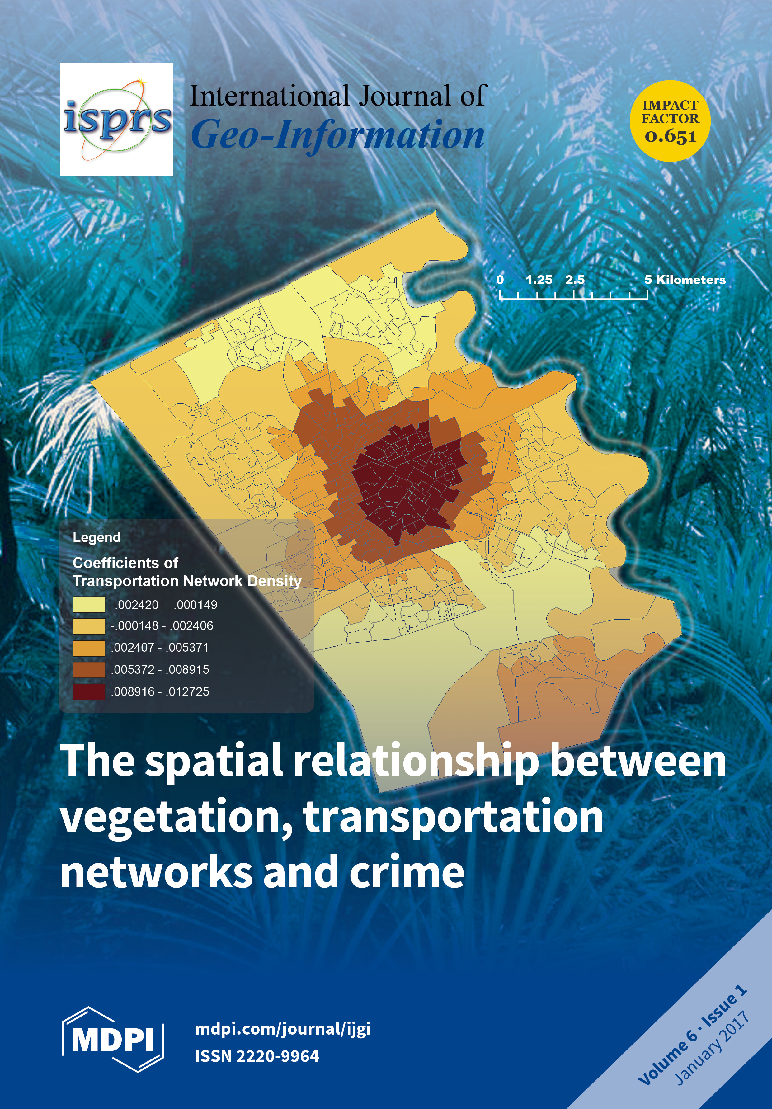
We investigated the spatial relationship between vegetation density, transportation network density and crime by using a quantitative method. Crimes against property and crimes against persons as well as four specific crime types were analyzed. Besides, the spatial variations of different relationships were explored across an urban central–peripheral gradient.
  • Issues are regarded as officially published after their release is announced to the table of contents alert mailing list .
  • You may sign up for email alerts to receive table of contents of newly released issues.
  • PDF is the official format for papers published in both, html and pdf forms. To view the papers in pdf format, click on the "PDF Full-text" link, and use the free Adobe Reader to open them.

Articles (32)

  • Article
  • Open Access
5 Citations
5,335 Views
21 Pages

The context in which a moving object moves contributes to the movement pattern observed. Likewise, the movement pattern reflects the properties of the movement context. In particular, big events influence human mobility depending on the dynamics of t...

  • Article
  • Open Access
3 Citations
4,643 Views
18 Pages

Fuzzy GML Modeling Based on Vague Soft Sets

  • Bo Wei,
  • Qingqing Xie,
  • Yuanyuan Meng and
  • Yao Zou

The Open Geospatial Consortium (OGC) Geography Markup Language (GML) explicitly represents geographical spatial knowledge in text mode. All kinds of fuzzy problems will inevitably be encountered in spatial knowledge expression. Especially for those e...

  • Article
  • Open Access
11 Citations
6,062 Views
13 Pages

Very high spatial resolution (VHSR) stereo-imagery-derived digital surface models (DSM) can be used to generate digital elevation models (DEM). Filtering algorithms and triangular irregular network (TIN) densification are the most common approaches....

  • Article
  • Open Access
3 Citations
5,945 Views
19 Pages

Monitoring, response, mitigation and damage assessment of disasters places a wide variety of demands on the spatial and temporal resolutions of remote sensing images. Images are divided into tile pyramids by data sources or resolutions and published...

  • Article
  • Open Access
44 Citations
8,998 Views
19 Pages

Understanding the Representativeness of Mobile Phone Location Data in Characterizing Human Mobility Indicators

  • Shiwei Lu,
  • Zhixiang Fang,
  • Xirui Zhang,
  • Shih-Lung Shaw,
  • Ling Yin,
  • Zhiyuan Zhao and
  • Xiping Yang

The advent of big data has aided understanding of the driving forces of human mobility, which is beneficial for many fields, such as mobility prediction, urban planning, and traffic management. However, the data sources used in many studies, such as...

  • Article
  • Open Access
36 Citations
7,013 Views
15 Pages

Multi-constellation global navigation satellite systems (GNSSs) are expected to enhance the capability of precise point positioning (PPP) by improving the positioning accuracy and reducing the convergence time because more satellites will be availabl...

  • Article
  • Open Access
14 Citations
5,567 Views
16 Pages

Given the chaotic characteristics of the time series of landslides, a new method based on modified ensemble empirical mode decomposition (MEEMD), approximate entropy and the weighted least square support vector machine (WLS-SVM) was proposed. The met...

  • Article
  • Open Access
21 Citations
7,098 Views
18 Pages

The near-repeat phenomenon refers to the increased risk of repeat victimization not only at the same location but at nearby locations up to a certain distance and for a certain time period. In recent research, near-repeat victimization has been repea...

  • Article
  • Open Access
4 Citations
6,135 Views
18 Pages

As the most active plateau on the Earth, the Qinghai-Tibet Plateau (TP) has a complex crust–mantle structure. Knowledge of the distribution of such a structure provides information for understanding the underlying geodynamic processes. We obtain a th...

of 4

Get Alerted

Add your email address to receive forthcoming issues of this journal.

XFacebookLinkedIn
ISPRS Int. J. Geo-Inf. - ISSN 2220-9964