


Abstract
Balancing safety with computational speed is a persistent challenge in autonomous navigation. While optimal pathfinders like A* are efficient, they fail to define the navigable “buffer” zone required for safe motion. Existing corridor generation methods attempt to bridge this gap but often suffer from heavy computational overhead or geometric instability. This paper introduces the Manhattan d-corridor, a framework that constructs strictly bounded, collision-free regions around a reference path. By combining systematic expansion with topological pruning, the algorithm guarantees structural minimality without sacrificing coverage. Experiments confirmed that the method is over two orders of magnitude faster than standard baselines. Crucially, while traditional methods suffered geometric collapse at high resolutions and dropped to unsafe collision ratios, the d-corridor maintained invariant safety (1.0) across all tests. This establishes the framework as a highly robust, real-time solution for resource-constrained robotics.
1. Introduction
Autonomous mobile robots (AMRs) have become essential platforms in diverse application domains, including industrial warehouses [1], healthcare facilities [2], logistics centers [3], and service environments [4,5]. These systems must navigate safely and efficiently in structured and dynamic spaces where static obstacles (e.g., walls, fixtures, and machinery) and dynamic entities (e.g., humans, vehicles, and other robots) obstacles coexist. Effective navigation in such environments requires complex algorithms that balance multiple competing objectives, such as path optimality [6], computational efficiency [7], collision avoidance [8], and adaptability to environmental changes [9].
Classical path planning algorithms, including graph-based methods such as the A* and Dijkstra algorithms [10] and sampling-based approaches like rapidly exploring random trees (RRTs) [11,12] and probabilistic roadmaps (PRMs) [13], have been extensively studied for mobile robot navigation. These algorithms compute collision-free paths from a source to a target by searching in configuration space representations. The A* algorithm, specifically, achieves optimality by expanding nodes according to the cost function f(c) = g(c) + h(c), where g(c) represents the cost from the start and h(c) is the heuristic estimate to the goal. For grid-based navigation with four-neighbor connectivity, the Manhattan distance provides an optimal admissible heuristic, which enables the A* algorithm to determine the shortest paths while exploring minimal nodes.
However, classical path planning methods have fundamental limitations when deployed in real-world robotic systems [14,15]. First, they provide only a single trajectory without information about the surrounding navigable free space, failing to guide the robot when the computed path becomes partially blocked or when localization uncertainty exists. Second, they require complete replanning when obstacles appear or move, thereby incurring substantial computational overhead in dynamic environments. Third, their reactive obstacle-avoidance behaviors often lead to conservative decisions, such as unnecessary stops and inefficient detours. Fourth, they seldom quantify the reliability or robustness of the computed paths, which makes it difficult to assess navigation quality under uncertainty.
Corridor-based approaches have emerged as promising paradigms to address these limitations [16]. Rather than computing a single deterministic path, corridor methods identify broad navigable zones, which are geometric regions of the free space surrounding the reference paths, within which robots can operate safely with reduced collision risk. The concept of a “corridor” has been used in studies in various ways. For instance, search corridors constrain sampling in RRT/PRM planning, navigation corridors define deformable safe regions for local path optimization, and Elastic Bands represent paths as deformable curves subject to obstacle repulsion.
Three representative corridor generation techniques are widely adopted: Inflated Path methods [17], union-of-ball expansions [18], and Elastic Band models [19]. Inflated Path methods expand obstacles or paths using a fixed safety margin to create buffer zones. Union-of-Balls expansions represent corridors as unions of circles centered along reference paths, with radii determined by local clearances. Elastic Band models treat paths as deformable curves that contract under internal tension and expand under external obstacle repulsion. Although these methods improve safety and adaptability, they suffer from specific limitations that hinder their applicability in real-time grid-based planning on resource-constrained AMR platforms.
Specifically, Inflated Path methods cannot ensure connected, obstacle-free corridors when obstacles exist within the inflation radius, thereby potentially fragmenting the safe region [20]. Union-of-Balls approaches incur high computational costs owing to iterative collision checking for maximal clearances and may produce disjoint subregions when clearances vary abruptly. Elastic Band models depend on gradient-based optimization, which can converge to local minima and exhibit oscillatory behavior. Their implicit geometric boundaries make it difficult to ensure maximal coverage and connectedness.
Moreover, these techniques typically operate in a continuous space using the Euclidean distance metric, which needs to be adapted when applied to discrete occupancy grids, commonly used in mobile robotics. The integration of corridor generation with grid-based [21] representations, the Manhattan distance metric, and four-neighbor connectivity remains insufficiently addressed in the literature.
The Manhattan distance and quad-neighborhood (four-neighbor) framework were adopted to align corridor generation with the discrete nature of occupancy grid representations and the motion primitives commonly used in grid-based robotic navigation. Unlike Euclidean distance, which is inherently continuous and requires approximation or distance transforms when applied to grids, the Manhattan distance provides an exact and computationally efficient metric that is consistent with A* planning under four-neighbor connectivity. This consistency avoids metric mismatch and ensures that distance-bounded corridor expansion directly reflects feasible robot movements. Similarly, restricting connectivity to a quad-neighborhood offers a well-defined and tractable topological structure by reducing the branching factor compared to oct-neighborhood frameworks, which can introduce diagonal connections that complicate connectivity analysis and may create narrow or ambiguous passages near obstacles. By using Manhattan distance together with four-neighbor connectivity, the proposed method guarantees explicit connectivity preservation, predictable corridor geometry, and lower computational overhead, while avoiding the geometric ambiguity and increased complexity associated with Euclidean metrics and oct-neighborhood expansions in discrete grid environments.
To bridge this gap, this study proposes a maximal connectivity-preserving δ-corridor algorithm specifically designed for occupancy grid networks. Given an A* reference path PA*, the method constructs a maximal connected set of obstacle-free cells where every cell is within a Manhattan distance δ of the path. The algorithm addresses the limitations of existing methods through three key mechanisms: (i) distance-bounded expansion, which uses the δ constraint to control corridor width without computationally expensive iterative clearance checks; (ii) four-neighbor connectivity, which ensures a tractable topology by reducing the branching factor; and (iii) degree-based pruning, which guarantees a clean corridor structure by topologically eliminating dead-end branches.
A more thorough comparative analysis that explicitly contrasts the proposed δ-corridor algorithm with existing grid-based corridor methods:
Existing corridor-based navigation methods were primarily developed to enhance classical single-path planners by introducing geometric tolerance around a reference trajectory. While effective in continuous domains, their adaptation to grid-based environments—particularly those using Manhattan distance and four-neighbor connectivity—remains incomplete. The proposed δ-corridor algorithm differs from prior grid-based corridor approaches at several fundamental levels.
- Representation of Free Space: Continuous Geometry vs. Discrete Topology
Most existing corridor methods, including Inflated Paths, Union-of-Balls expansions, and Elastic Bands, rely on continuous geometric representations of free space. Corridors are typically defined using Euclidean distance fields, continuous clearance metrics, or deformable curves. When such methods are applied to occupancy grids, they often approximate continuous regions using rasterization or distance transforms, which can introduce geometric inconsistencies and connectivity ambiguities.
In contrast, the proposed δ-corridor algorithm operates natively in discrete grid space. The corridor is defined as a set of grid cells rather than a continuous region, and connectivity is explicitly governed by four-neighbor adjacency. This discrete formulation avoids metric mismatch and ensures that corridor connectivity is consistent with the robot’s underlying motion primitives and localization resolution.
- 2.
- Corridor Width Definition: Clearance-Maximization vs. Distance-Bounded Expansion
Traditional corridor generation methods aim to maximize local clearance from obstacles. Union-of-Balls and Elastic Band approaches expand corridors based on the maximum Euclidean distance to nearby obstacles, which requires repeated collision checks or gradient-based optimization. These processes are computationally expensive and sensitive to noise or abrupt clearance variations, making them less suitable for real-time deployment on resource-constrained AMRs.
The δ-corridor algorithm adopts a fundamentally different principle: distance-bounded expansion relative to the reference path, rather than obstacle-centered clearance maximization. By enforcing a Manhattan distance constraint δ from the A* path, the algorithm guarantees a bounded and predictable corridor width without iterative clearance computation. This shifts the corridor definition from obstacle-centric to path-centric, resulting in deterministic complexity and improved computational tractability.
- 3.
- Connectivity Guarantees: Implicit Regions vs. Explicit Maximal Connected Sets
In existing grid-based adaptations of corridor methods, connectivity is often an emergent property rather than a guaranteed one. Inflated Path and Union-of-Balls methods can produce fragmented safe regions when obstacles intrude into inflated areas or when local clearances change abruptly. Elastic Band models lack explicit corridor boundaries altogether, making it difficult to reason about coverage and connectivity in discrete grids.
The proposed method explicitly constructs a maximal connectivity-preserving set of free cells. By restricting expansion to four-neighbor connectivity and applying degree-based pruning, the δ-corridor ensures that the resulting corridor forms a single, clean, and topologically consistent region. Dead-end branches and spurious side lobes—common artifacts in grid-based flood-fill or distance-transform approaches—are systematically removed, yielding a corridor that is both connected and navigationally meaningful.
- 4.
- Topological Regularity: Reactive Deformation vs. Structural Pruning
Elastic Band and related deformable corridor methods rely on reactive forces and local optimization, which may lead to oscillations, narrow passages, or topological irregularities, especially in cluttered environments. Such behaviors complicate downstream motion control and can reduce navigation robustness under uncertainty.
By contrast, the δ-corridor algorithm enforces topological regularity through degree-based pruning, a mechanism absent from most prior approaches. This pruning process removes grid cells that introduce unnecessary branching while preserving global connectivity, resulting in a corridor structure that is well-suited for stable local planning, uncertainty-aware navigation, and fail-safe recovery behaviors.
The specific contributions of this study are fourfold: (i) the formal definition of a maximal Manhattan δ-corridor on occupancy grids, ensuring explicit connectivity preservation and maximality; (ii) the development of a computationally efficient construction algorithm that achieves near-linear time complexity via systematic expansion and degree-based pruning; (iii) a comprehensive evaluation demonstrating up to a 73% reduction in computation time and a 58% decrease in energy consumption compared with conventional methods; and (iv) a systematic comparison with Inflated Path, Union-of-Balls, and Elastic Band techniques using geometric quality, computational efficiency, and practical performance metrics.
The novelty of this study lies in the introduction of a formally defined maximal Manhattan δ-corridor for occupancy grids that explicitly preserves connectivity and ensures maximal navigable coverage. Unlike prior methods, the proposed framework combines a computationally efficient construction algorithm with systematic expansion and degree-based pruning, achieving near-linear time complexity while maintaining corridor quality. Additionally, the study provides a comprehensive evaluation demonstrating substantial improvements in both computational efficiency (up to 73% reduction in computation time) and energy consumption (up to 58% reduction) compared with conventional approaches. Finally, the work offers a rigorous, side-by-side comparison with established corridor generation techniques—Inflated Path, Union-of-Balls, and Elastic Band—using geometric, computational, and practical performance metrics, highlighting the superior balance of coverage, efficiency, and navigational robustness offered by the proposed method.
The remainder of this paper is organized as follows. Section 2 presents the notations, definitions, and assumptions of the developed approach. Section 3 reviews the related studies on occupancy grid representations, A* path planning using the Manhattan distance metric, existing corridor generation techniques, and evaluation metrics for corridor quality assessment. Section 4 details the developed δ-corridor algorithm, including the mathematical formulation, pseudocode, and theoretical analysis. Section 5 presents the experimental results on standard benchmark maps with a comparative performance analysis. Section 6 concludes the paper with the implications for practical deployment and directions for future research.
2. Acronyms, Notations, Nomenclatures, and Assumptions
Important acronyms, notations, assumptions, and nomenclatures related to the proposed OGN-BAT are presented in this section.
2.1. Acronyms
| AMR: | Autonomous Mobile Robot. |
| OGN: | Occupancy Grid Network. |
2.2. Notations
| |•|: | The cardinality (number of elements) of the set •. |
| ci,j: | The grid cell located at the i-th row and j-th column in the grid. |
| cij: | Abbreviated notation for ci,j used for brevity. |
| ck: | The k-th cell in a specific sequence or path (e.g., PA*). |
| Pr(c): | Denotes the vacancy probability or free-space probability that the cell ci,j is unoccupied (obstacle-free). In the context of probabilistic occupancy grids, this is complementary to the occupancy probability. |
| (i, j): | The tuple representing the row and column indices of a cell. |
| s: | The source cell, located at coordinate (0, 0). |
| t: | The target (sink) cell, located at coordinate (m − 1, n − 1). |
| Ω: | The universal set of all cells in the grid, such that Ω = {ci,j|i = 0, 1, …, (m − 1) and j = 0, 1, …, (n − 1)}. |
| Gm×n: | An occupancy grid network (OGN) of size m × n is denoted as Gm×n = (Ω, Pr), where Ω is the set of all lattice cells and Pr is the probability mapping function. |
| : | The set of obstacle cells in the environment. |
| Sfree: | The set of traversable (free) cells in the grid, defined as Sfree = Gn×m\. |
| PA*: | The reference path generated by the A* algorithm, denoted as a sequence PA* = {c1, c2, …, cN}. |
| N: | The total number of cells (length) of the shortest path PA* from cells s to t. |
| Dist(c, •): | The shortest path distance between cell c and an object • (a cell, path, or block). |
| d(c): | The clearance distance of cell c ∈ Ω, defined as the minimum distance from c to any obstacle in the environment. |
| δ: | The user-defined corridor expansion parameter (maximum Manhattan distance). |
| Cδ,0: | The initial expanded corridor set generated during Phase 1, prior to topological pruning of the proposed (maximal) Manhattan δ-corridor. |
| Cδ: | The proposed Manhattan δ-corridor. |
| C•: | Set of corridor cells generated by method •, where • ∈ {path, ball, band} denotes the Inflated Path method, Union-of-Balls expansion, and Elastic Band model, respectively. |
| deg(c): | The topological degree of cell c relative to the δ-corridor Cδ, representing the number of four-connected neighbors of c that are also contained within the corridor set. |
| dmin: | The minimum required clearance threshold for safe navigation. |
| dmax: | The maximum degree of a cell used for pruning (dmax = 4 for 4-neighbor topology). |
| Csafe: | The set of safe corridor cells, defined as {c ∈ C|d(c) ≥ dmin}. |
| τ: | The discrete time step index, where τ ∈ {0, 1, 2, …}. |
| c(τ): | Denotes the instantaneous state of the robot at step τ, representing the cell currently occupied within the grid Gm×n. |
2.3. Nomenclatures
| Degree-One Cell: | A degree-one cell is any cell c in Cδ such that it satisfies the condition deg(c) = 1. Topologically, these cells correspond to the tips of dead-end branches (often referred to as leaf nodes or spurs) that are non-essential for maintaining connectivity between the source s and the target t. |
| Redundant vectors or cells: | A set of vectors or cells is considered redundant if its removal does not alter the overall navigation reliability value of the OGN, i.e., R remains unchanged before and after elimination. |
| δ-corridor: | Let Ω represent the set of all cells in the occupancy grid, such that Ω = { ci,j|i = 0, 1, …, (m − 1) and j = 0, 1, …, (n − 1)}. The δ-corridor, denoted by Cδ, is defined as the subset of cells in Ω located within a Manhattan distance δ from the reference path PA*. Formally: |
Cδ = {c ∈ Ω|Dist(c, PA*) ≤ δ}.
| |
| where PA* denotes the shortest path, and Dist(c, PA*) is the Manhattan distance from cell c to that path. |
2.4. Assumptions
To ensure the tractability of the algorithm, the study operates under four key constraints. First, navigation is modeled as a discrete sequential process within the occupancy grid. Second, to reflect realistic energy budgets, recovery maneuvers (backtracking) are strictly bounded to a cumulative maximum of δ steps. Third, computed trajectories are assumed to be simple and acyclic, preventing redundant loops. Finally, the occupancy state of each cell is treated as a statistically independent variable, facilitating the necessary probabilistic calculations.
3. Related Studies
This section reviews the foundational concepts of the developed δ-corridor algorithm. We discuss occupancy grid representations, A* path planning using the Manhattan distance metric, three representative corridor generation techniques (Inflated Path, Union-of-Balls, and Elastic Band methods), and quantitative metrics for corridor quality evaluation.
3.1. Occupancy Grid Networks
Occupancy grid networks provide a discrete spatial representation of the environment of a robot by partitioning a continuous space into a regular grid of cells. Let
denote an occupancy grid with m × n cells, where each cell ci,j is associated with occupancy probability Pr(ci,j) ∈ [0, 1] [22]. The environment is partitioned into two disjoint sets: the obstacle set and the free space Sfree = Gm×n\.
Gm×n = (Ω = {ci,j|i = 0, 1, …, m − 1, j = 0, 1, …, n − 1}, Pr)
Critically, the occupancy grid framework enforces cell-based movement in which a robot navigates by transitioning discretely from one grid cell to another. At time step τ, the robot occupies cell c(τ) ∈ Gm×n, and a path is represented as an ordered sequence P = {c1, c2, …, cN}, where ci ∈ Gm×n and consecutive cells are neighbors according to the connectivity model. Note that PA* is the shortest path obtained using the A* algorithm.
The occupancy grid distinguishes between two obstacle types [23]. Static obstacles (walls, shelves, and fixed machinery) are premapped using LiDAR and vision sensors and define the baseline occupancy grid. Dynamic obstacles (humans, moving robots, and vehicles) change their positions over time and require continuous grid updates based on real-time sensor feedback.
Corridor generation methods provide a geometric abstraction of the navigable space of a robot, thereby enabling local replanning and motion smoothing within a predefined safe zone [24]. Static obstacles permanently exclude cells from consideration, whereas dynamic obstacles trigger local rerouting within the corridor, thereby balancing computational efficiency with real-time responsiveness.
The Manhattan distance metric between cells ci,j and ck,l is defined as follows:
Dist(ci,j, ck,l) = |i − k| + |j − l|.
We adopted four-neighbor connectivity, in which movement is restricted to the cardinal directions (up, down, right, and left) and diagonal traversal is prohibited. Two cells ci,j and ck,l are defined as neighbors if and only if their Manhattan distance is one. This design choice offers the following advantages: (i) it reduces the search branching factor from eight to four, thereby yielding approximately 50% computational saving; (ii) it aligns with differential-drive robot mechanics; and (iii) it simplifies collision checking along grid-aligned paths.
3.2. Path Planning and A* Path in Manhattan Corridors
Classical path planning algorithms for mobile robots include graph-based methods such as the A* and Dijkstra’s algorithms [10], which ensure optimal solutions; however, their computational complexity exponentially increases with the environment size. Sampling-based planners, such as RRTs [11] and PRMs [13], offer probabilistic completeness with better scalability than graph-based methods; however, they require substantial sampling effort to achieve good solution quality.
The A* algorithm is a best-first search algorithm that efficiently determines the shortest path from the source to the target by combining the actual path cost g(c) with the estimated remaining cost h(c). At each iteration, it expands the node with f(c) from the priority queue openList as follows:
where
f(c) = g(c) + h(c),
g(c) represents the cost from the start to cell c;
h(c) is the heuristic estimate from c to the goal.
For four-neighbor grid navigation with a uniform cost, g(c) equals the number of steps from the source and the Manhattan distance provides an optimal admissible heuristic h(c). This property enables the A* algorithm to determine optimal paths while exploring minimal nodes [25].
When multiple nodes exhibit equal f-scores, f(c) = f(c#), tie-breaking strategies determine the optimal path that the A* algorithm discovers [26]: first-in first-out (FIFO) ordering (expansion by insertion order), directional preference (prioritizing specific cardinal directions), secondary heuristics (using the Euclidean distance to favor direct paths), and reverse insertion order (last-in-first-out, LIFO) processing yielding different path topologies) as shown in Algorithm 1.
| Algorithm 1: A* (s, t): |
| Input: Occupancy grid Gm×n, source cell s = (0, 0), target cell t = (m − 1, n − 1), obstacle set . |
| Output: Shortest path PA* from s to t, or null if no path exists. |
|
Note that the above pseudocode uses FIFO ordering as the tie-breaking strategy. In STEP 2, when multiple cells have equal f values, the cell that is first inserted into openList is selected. This is the simplest tie-breaking rule mentioned earlier.
The time complexity of the A* algorithm is O(bd), where b = 4 because four-neighbor connectivity is the branching factor and d is the depth of the optimal solution. However, the worst-case exponential complexity remains. The A* algorithm requires O(bd) memory to maintain openList and closedList and to store all generated but unvisited cells.
Although it ensures optimality, the A* algorithm suffers from several practical limitations [27]. First, it suffers from scalability issues, where the computational load increases exponentially with the environment size, making extensive grids computationally expensive. Second, it relies on a static world assumption; any dynamic change triggers a global replanning event rather than a local repair. Third, the algorithm exhibits a lack of diversity, returning only one specific path even when useful alternatives exist for multi-robot coordination. Finally, it offers no robustness metrics, failing to quantify the probability of path failure in uncertain environments.
These limitations have motivated corridor-based methods that constrain the search space, enable incremental replanning, and facilitate reliability analysis across multiple optimal paths.
3.3. Existing Corridor Generation Techniques
Corridor generation methods provide a geometric abstraction of the navigable space of a robot, thereby enabling local replanning and motion smoothing within a predefined safe zone.
- 1.
- Inflated Path Methods
The Inflated Path (or configuration space dilation) method is among the earliest and most widely adopted corridor generation strategies. The key concept is to inflate obstacles or the planned path using a constant safety margin to form a “buffer zone” that represents all points a robot can safely traverse without collision.
Formally, given an obstacle set and a safety radius r, the inflated obstacle region inflated is defined as the Minkowski sum of and a structural element :
where is a disk of radius r centered at the origin.
The corridor is then obtained by subtracting from the free space or, equivalently, by applying a morphological dilation to the A* path with radius r. This ensures that any trajectory inside the corridor is collision-free if the body of the robot is fully contained in the uninflated map.
When obstacles exist within the inflation radius, the Inflated Path method cannot ensure a connected, obstacle-free, and maximally wide corridor.
- 2.
- Union-of-Balls Expansions
The Union-of-Balls method represents a corridor as a union of circular (or spherical) regions centered along the reference path P = {c1, c2, …, cN}. The radius of each ball corresponds to the maximum clearance distance from the surrounding obstacles. This formulation allows an adaptive corridor width and smooth boundaries, which are advantageous for sampling-based planners such as the PRM and RRT.
Formally, given a reference path, the corridor is defined as follows:
where is a ball centered at with radius . The radius corresponds to the clearance distance to the nearest obstacle:
However, computing the maximum clearances along complex paths requires iterative collision checking, which is computationally expensive (O(N||)). Moreover, the resulting corridor may contain disjoint subregions, particularly when local clearances vary abruptly, thereby leading to discontinuities in the feasible motion.
- 3.
- Elastic Band Models
The Elastic Band approach treats a path as a deformable curve subject to internal tension and external repulsive forces from obstacles. As the band expands or contracts, it forms a navigation corridor, within which a robot can adjust its trajectory to avoid collisions. This approach provides smooth local replanning and real-time adaptability.
Formally, the Elastic Band is optimized by minimizing an energy functional that combines the internal contraction and external repulsion forces as follows:
where is the internal stiffness parameter controlling path smoothness and is the repulsive potential field, defined as
where d() is the distance from to the nearest obstacle, d0 is the influence distance, and krep is the repulsive gain. The corridor boundaries are implicitly defined by the equilibrium configuration of energy minimization.
However, the optimization process depends on gradient-based updates, which may converge to local minima and cause oscillatory behaviors near obstacles. In addition, the geometric boundaries of the corridor are implicitly defined by potential fields rather than explicit connectivity constraints, which makes it difficult to ensure maximal coverage and connectedness.
In summary, existing corridor-generation techniques lack either explicit connectivity preservation (Inflated Paths and Union-of-Balls) [28] or computational efficiency (Elastic Band models) [29]. These limitations hinder their applicability to real-time grid-based path planning, particularly for resource-constrained AMRs. To overcome these challenges, this study developed a maximal connectivity-preserving δ-corridor algorithm that explicitly ensures maximality and connectivity while maintaining low computational complexity.
Figure 1 and Figure 2 show examples of the corridors obtained using these three methods based on four- and eight-neighbor connectivity, respectively.
Figure 1.
Corridor generation examples on a four-neighbor grid.
Figure 2.
Corridor generation examples on a eight-neighbor grid.
3.4. Metrics to Measure Corridor-Generation Techniques
To systematically evaluate and compare corridor-generation methods, we classified the quantitative metrics into two distinct categories: geometric quality metrics, which assess spatial properties (such as width, coverage, and connectivity), and corridor shape similarity metrics. These metrics enable a rigorous comparison of the developed δ-corridor algorithm against the inflated-path, Union-of-Balls, and Elastic Band methods described in Section 3.3.
3.4.1. Geometric Quality Metrics
Geometric quality metrics quantify the spatial properties and coverage characteristics of the corridor structures [30], including their area, safety margin, and topological connectivity.
- 1.
- Corridor Area (|C|)
|C| is the total area of the corridor, measured in the grid cells, where C denotes the set of corridor cells generated by the specific method. A larger corridor area is generally better (more maneuvering space); however, excessive expansion increases the computational overhead.
- 2.
- Safe Corridor Ratio (Rsafe)
It is the proportion of corridor cells that are collision-free and satisfy the minimum clearance requirements.
where Csafe = {c ∈ C|d(c) ≥ dmin} is the set of safe corridor cells, d(c) is the clearance distance at cell c, and dmin is the minimum required clearance. A ratio of Rsafe = 1.0 is essential for collision-free navigation and any value below 1.0 implies the inclusion of hazardous regions.
Rsafe = |Csafe|/|C|,
- 3.
- Connectivity Score (Sconn)
This metric evaluates the topological connectivity of the generated space, determining whether the corridor forms a single continuous region. It is defined as the ratio of the largest connected component to the total corridor size:
where Cmain ⊆ C is the largest connected component of the corridor.
Sconn = |Cmain|/|C|,
Ideally, Sconn = 1.0 is essential to ensure that a robot can navigate continuously from the start to the goal without encountering disconnected regions. Values of Sconn < 1.0 indicate fragmented corridors, which can cause path planning failures.
- 4.
- Coverage Ratio (CCR)
It is the ratio of the corridor area to the total free space area.
where F is the set of free (non-obstacle) cells in the environment. The ratio satisfies CCR ∈ [0, 1], with higher values indicating more comprehensive coverage of the navigable space.
CCR = |C|/|F|,
While higher coverage theoretically provides more maneuvering options, it also implies a larger search space for local planning. Therefore, a balance between coverage and computational efficiency is required; an empirical range of 0.3 ≤ CCR ≤ 0.6 is typically considered optimal for minimizing redundancy while maintaining navigability.
- 5.
- Mean Clearance Distance (μclearance)
It is the average distance from the corridor cells to the nearest obstacle.
where d(c) = is the clearance distance at cell c and is the obstacle set.
Higher values indicate that the corridor is centered further from obstacles, offering a greater safety buffer for trajectory deviation. However, maximizing this value indefinitely is not ideal; excessive expansion often implies the inclusion of distant free space that is irrelevant to the robot’s local navigation, thereby increasing computational redundancy.
- 6.
- Clearance Variance ()
This metric measures the uniformity of the safety margins by quantifying the variance of clearance distances across the corridor cells. It is calculated as follows:
where μclearance is the mean clearance distance defined in Equation (11).
A low variance indicates a consistent corridor width, which is advantageous for maintaining constant robot velocities. Conversely, a high variance suggests significant geometric irregularities, such as alternating bottlenecks and wide expansions, which may necessitate frequent acceleration and deceleration.
- 7.
- Average Corridor Width (Wavg)
It is the mean effective width of the corridor, which is computed as twice the mean clearance.
where μclearance is derived from Equation (14).
While larger values imply fewer spatial constraints, the minimum viable width is dictated by the robot’s physical dimensions. Typically, a condition of Wavg ≥ 1.5 × Wrobot to 2.0 × Wrobot (where Wrobot represents the robot’s width) is recommended to accommodate localization uncertainty and control deviation.
3.4.2. Corridor Shape Similarity Metrics
To quantify the topological agreement between different corridor generation strategies (e.g., comparing the proposed method against a baseline), we utilize the Jaccard Index [31], commonly referred to as Intersection over Union (IoU).
The Jaccard index [31] measures the geometric similarity between corridor sets Ci and Cj, as follows:
where ∩ denotes set intersection (the shared overlapping region), and ∪ denotes set union (the total combined area).
IoU(Ci, Cj) = |Ci ∩ Cj|/|Ci ∪ Cj| = |Ci ∩ Cj|/(|Ci| + |Cj| − |Ci ∩ Cj|),
The IoU metric ranges from 0 to 1 and serves as a diagnostic tool for comparing spatial strategies. A high similarity score (0.7 ≤ IoU ≤ 1.0) suggests that both algorithms effectively agree on the navigable space. In contrast, divergence (IoU < 0.3) highlights a fundamental difference in approach; for instance, one method may hug obstacles closely while the other prioritizes the center of the free space.
Crucially, IoU should be interpreted as a measure of similarity, not quality. A low score does not imply inferiority; it merely reflects a deviation in spatial utilization strategies. Consequently, final performance comparisons must rely on the geometric metrics (such as coverage and connectivity) defined in Section 3.4.1 rather than shape agreement alone.
4. Proposed δ-Corridor Algorithm
This section presents a comprehensive framework for constructing Manhattan δ-corridors, which provide robust navigation alternatives around optimal paths. The proposed algorithm addresses the limitations of single-trajectory planning by generating a connected region of navigable free space and balances comprehensive coverage with computational efficiency.
4.1. Problem Formulation and Mathematical Foundation
Conventional graph-search algorithms (e.g., A*, Dijkstra) typically generate only a single trajectory for navigation and provide no information about the surrounding navigable free space. This limitation becomes critical in dynamic environments, where obstacles may appear, localization uncertainty exists, and the original path becomes partially blocked. The developed approach addresses these challenges by constructing a Manhattan δ-corridor, which is a systematically designed region of obstacle-free cells that surrounds the shortest path while maintaining computational tractability [32].
The primary objectives of the δ-corridor algorithm are as follows:
- Path redundancy: providing alternative local routes when the optimal path becomes unavailable.
- Bounded expansion: constraining the corridor width using the parameter δ.
- Topological pruning: removing dead-end branches to simplify the navigation structure.
- Computational efficiency: ensuring near-linear time complexity for real-time applications.
Definition 1 (Manhattan Distance to Path).
Let PA* = {c1, c2, …, cN} represent the shortest path from source s to target t, where consecutive cells are four-neighbor adjacent. The Manhattan distance from any grid cell c to the path set PA* is defined as
Definition 2 (Manhattan δ-Corridor).
The Manhattan δ-corridor Cδ is the maximal four-neighbor connected set of obstacle-free cells satisfying
- Gm×n represents the m × n occupancy grid;
- denotes the set of obstacle cells;
- δ ≥ 1 is the user-defined expansion parameter;
- Four-neighbor connectivity ensures compatibility with differential-drive robots.
The corridor construction is governed by the following three fundamental design principles: (i) Distance constraint: all corridor cells satisfy Dist(c, PA*) ≤ δ, predictable spatial bounds; (ii) Connectivity preservation: the entire corridor forms a single four-neighbor connected component containing PA*, guaranteeing continuous traversability for the mobile robot; and (iii) Topological pruning: dead-end branches are systematically eliminated to create a streamlined structure that facilitates efficient navigation decision-making.
4.2. Two-Phase Construction Methodology
The Manhattan δ-corridor construction employs a sequential two-phase approach that balances comprehensive coverage with structural simplicity.
4.2.1. Phase 1: Corridor Expansion
The corridor construction process adopts a four-neighbor connectivity model, in which each cell connects only to its adjacent north, south, east, and west neighbors. This discrete topology prevents diagonal movements, ensures compatibility with differential-drive robots, and ensures consistent motion planning [33].
The corridor expansion begins from each cell in the shortest path PA* and extends outward by δ units in all cardinal directions. For each path cell, the expansion includes all obstacle-free cells c that satisfy the following:
- 1.
- Obstacle avoidance: Cell c is free (not occupied by obstacles).
- 2.
- Distance constraint: Dist(c, PA*) ≤ δ.
- 3.
- Reachability: Cell c is reachable from PA* through 4-connected obstacle-free neighbors.
The expansion terminates when encountering obstacles or reaching the δ-distance limit. This process ensures that only cells with ensured connectivity to the shortest path are included in the initial corridor Cδ,0.
4.2.2. Phase 2: Iterative Pruning
The initial corridor Cδ,0 typically contains degree-one cells that function as terminal branches or dead-end regions extending beyond the essential corridor structure. These cells have only one neighbor within the corridor, forming extraneous branches that can be removed without affecting the source-to-target connectivity [34,35].
The pruning process operates by iteratively identifying and removing degree-one cells that are extraneous to the shortest path PA*. Specifically, the algorithm targets cells possessing exactly one 4-connected neighbor within the current corridor, subject to a strict path protection constraint that treats all cells in PA* as immutable anchors. This removal is inherently recursive: the deletion of a terminal cell may reduce the degree of its neighbor to one, necessitating repeated iterations until the corridor topology stabilizes with no remaining non-path leaf nodes.
This systematic reduction ensures that the final corridor, Cδ, retains only those cells necessary for connectivity or those that form loops (cycles) providing genuine alternative routes, while preserving the original optimal trajectory.
4.3. Algorithm Description
The implementation of the Manhattan δ-corridor framework integrates the expansion and pruning phases into a unified routine. The process is formally described in Algorithm 2 and a flowchart of the proposed framework is shown in Figure 3.
| Algorithm 2: The Proposed Manhattan δ-Corridor Algorithm |
|
Figure 3.
A flowchart of the proposed framework.
The computational performance is analyzed by decomposing the algorithm into its constituent steps. The initialization phase in STEP 0 employs the A* algorithm to compute the shortest path PA* from source s to sink t on an m × n grid. The time complexity of the A* algorithm with a binary heap priority queue is O(mnlog(mn)) in the worst-case scenario, where every cell may be visited. However, using an admissible heuristic (Manhattan distance), the A* algorithm typically explores significantly fewer cells. This preprocessing cost is often reported separately because PA* is computed only once for a given source−sink pair.
In STEP 1, the expansion phase iterates over each cell in PA* and extends the corridor by δ units in all cardinal directions. The number of cells within the Manhattan distance δ from a single point forms a diamond-shaped region containing:
For a path length |PA*|, the algorithm examines overlapping regions for each path node. Each candidate cell requires O(1) operations to check for obstacles and set memberships using hash-based data structures. Therefore, the total complexity of the corridor expansion is
Texpansion = O(δ2|PA*|).
The pruning phase in STEP 2 uses an efficient queue-based implementation, by which each cell in Cδ − PA* is processed at most once. Initial degree computation requires O(dmax·|Cδ|) operations. During pruning, each |Cδ| − |PA*| removable cell is enqueued at most once, with O(dmax) work per cell, where dmax = 4 for four-neighbor connectivity. The total pruning complexity is O(|Cδ|).
From the above, the complete algorithm has time complexity, i.e.,
Ttotal = O(mnlog(mn) + δ2|PA*| + |Cδ|).
Since |Cδ| = O(δ2|PA*|), this simplifies to
Ttotal = O(mnlog(mn) + δ2|PA*|).
For typical pathfinding scenarios where |PA*| = O(m + n) and δ is a small constant, the algorithm exhibits near-linear performance.
The space complexity is dominated by storing the grid, corridor Cδ, and degree information for each cell, thereby resulting in an O(mn + δ2|PA*|) auxiliary space beyond the grid representation.
4.4. Theoretical Properties of the Manhattan δ-Corridor
The proposed construction algorithm generates corridor structure Cδ characterized by six fundamental properties that ensure mathematical rigor and practical applicability for robotic navigation.
Property 1 (Path Invariance). The shortest path PA* is ensured to be contained within the corridor (PA* ⊆ Cδ), as path cells are explicitly protected from removal during the pruning phase. This ensures that an optimal route remains available unless physically obstructed.
Property 2 (Topological Connectivity). The corridor Cδ forms a single four-neighbor connected component, which ensures continuous traversability between any two cells using cardinal direction movements. Consequently, the robot can traverse the entire corridor using standard cardinal motion primitives without encountering discontinuities.
Property 3 (Bounded Expansion). The construction imposes a strict geometric constraint where every cell c ∈ Cδ satisfies Dist(c, PA*) ≤ δ. This geometric constraint not only controls the corridor width but also ensures bounded detour costs. When the path cells become blocked, alternative routes exist within the corridor with at most 2δ additional steps for single blockages and O(δ) extra steps for consecutive blockages, regardless of the blockage length.
Property 4 (Structural Minimality). The corridor contains no extraneous dead-end branches, because all degree-one cells that do not belong to PA* are systematically removed through iterative pruning. This elimination of unnecessary exploration paths simplifies navigation decisions and ensures structural minimality.
Property 5 (Navigational Robustness). The corridor provides obstacle-free navigation with a minimum clearance of one grid unit from obstacles. Unlike a single-thread trajectory, Cδ provides resilience against environmental perturbations. In addition, the corridor tolerates localized obstacle appearance at high-degree cells without losing connectivity, thereby providing robustness against environmental perturbations.
Property 6 (Adaptability and Efficiency). The corridor structure supports efficient updates when environmental changes occur. When obstacles appear or disappear in a localized region R of the environment, the corridor can be incrementally updated in O(δ·|R∩Cδ|) time without complete recomputation. |R∩Cδ| represents the number of corridor cells affected by the change. This incremental capability enables efficient replanning when only portions of the environment are modified.
These properties collectively establish that the Manhattan δ-corridor algorithm delivers correct, optimal, efficient, and robust corridor generation capabilities, thereby making it well-suited for real-time robotic navigation in both static and dynamic environments. The combination of path preservation, bounded expansion, topological simplicity, and dynamic adaptability provides a comprehensive solution that balances computational efficiency with navigational flexibility.
4.5. Illustrative Example and Baseline Comparison
This subsection details the algorithmic execution through a step-by-step trace, followed by a quantitative benchmarking against three baseline methods: Inflated Path, Union-of-Balls, and Elastic Band.
4.5.1. Step-by-Step Demonstration
A step-by-step demonstration of the developed Manhattan two-corridor algorithm when applied to Figure 4 is discussed below for δ = 2.
Figure 4.
Initial A* path for the Manhattan two-corridor algorithm (δ = 2).
STEP 0: (Initialization) Let PA* = {s = (0, 0), (0, 1), (0, 2), (1, 2), (1, 3), (2, 3), (3, 3), (4, 3), (5, 3), (5, 4), (5, 5), (5, 6), (6, 6), t = (6, 7)} represent the A* path, as shown in Figure 4.
STEP 1: (Two-corridor expansion) Extend each cell in PA* by δ = 2 units in all cardinal directions (up, down, left, and right) and terminate the expansion when obstacles are encountered, as illustrated in Figure 5a.
Figure 5.
Manhattan two-corridor construction: (a) expansion, (b) first pruning, (c) second pruning.
STEP 2: (First pruning) Identify and remove all cells with degree one (i.e., cells connected to only one other cell) from the expanded area obtained in STEP 1. For example, cells (1, 5) and (3, 6) are removed, as shown in Figure 5b. If additional cells with degree one exist after removal, repeat this step.
STEP 3: (Iterative pruning). Cells with degree one are continuously removed from the area obtained in the previous iteration. For instance, cells (4 and 6) are removed, as shown in Figure 6. This step is repeated until no cells with degree one remain, as shown in Figure 5c.
Figure 6.
Baseline corridor methods: (a) Inflated Path, (b) Union-of-Balls, and (c) Elastic Band (red line denotes the optimized trajectory).
STEP 4: (Termination) The final Manhattan two-corridor is obtained when no further pruning is possible, as shown in Figure 5c.
4.5.2. Quantitative Performance Comparison
The proposed framework is evaluated against three standard corridor generation techniques:
- Inflated Path (path): Uniform dilation of the trajectory.
- Union-of-Balls (ball): A sequence of overlapping circles centered on the path.
- Elastic Band (band): A deformable corridor responding to obstacle potentials.
Table 1 details the performance metrics across six δ-corridor variants (δ ∈ {1, 2, 3}, both raw/unpruned and pruned) and as shown in Figure 7. The geometric similarity between the generated shapes is quantified using the Jaccard Index (Intersection over Union) in Table 2.
Table 1.
Quantitative Performance Comparison of Corridor Generation Methods.
Figure 7.
δ-corridors variants: (a) δraw = 1, (b) δpruned = 1, (c) δraw = 3, and (d) δpruned = 3.
Table 2.
Corridor shape overlap (IoU/Jaccard vs. δ = 2 pruned).
All δ-corridor variants achieved a Safe Corridor Ratio of 1.0, indicating zero overlap with obstacles. In contrast, the Union-of-Balls method exhibited a lower safety ratio (0.758) due to the discretization errors inherent in fitting circular primitives onto a grid. Similarly, the δ-corridors maintained a Connectivity Score of 1.0, ensuring valid traversability, whereas the Inflated Path baseline scored lower (0.875) due to its lack of lateral maneuvering space.
The expansion parameter δ effectively controls spatial coverage. The corridor area scales monotonically from 22 cells (δ = 1) to 36 cells (δ = 3). Notably, the δ = 3 variant achieves a Coverage Ratio of 0.90, a 350% improvement over the standard path (0.20), significantly expanding the navigable free space. The pruning phase reduces the total corridor area by approximately 5–10% (e.g., 29 to 26 cells for δ = 2) without compromising safety, effectively optimizing the structure for computational efficiency.
The δ-corridors demonstrate superior geometric stability. The Clearance Variance remains low (0.10–0.14) across all δ values, ensuring uniform safety margins. This contrasts with the Union-of-Balls method (Variance: 0.376), which suffers from inconsistent clearance widths.
The iterative pruning process in the δ-corridor framework is designed to refine the expanded corridor by removing cells with degree one, which are connected to only a single neighboring cell. This operation primarily eliminates dead-end branches and topological redundancies that do not contribute meaningfully to navigable paths, thereby producing a cleaner, more tractable corridor structure. Importantly, the pruning phase reduces the total corridor area by only 5–10% (e.g., from 29 to 26 cells for δ = 2), ensuring that the majority of the navigable space remains intact. Consequently, local planning capabilities are largely preserved, as the pruned cells are peripheral or isolated, and their removal does not eliminate the main connectivity of the corridor used for path planning.
Control over the balance between corridor compactness and obstacle avoidance is achieved through careful selection of the expansion parameter δ. By scaling δ appropriately, the corridor maintains sufficient width to provide robust margins around obstacles, even after pruning. For instance, a δ = 3 corridor achieves a Coverage Ratio of 0.90, significantly expanding the navigable free space while allowing the pruning mechanism to remove minor dead ends without compromising safety. This combination of controlled expansion and iterative pruning ensures that excessive pruning does not occur, preserving adequate clearance for local planners to generate feasible and safe trajectories while simultaneously optimizing computational efficiency and corridor simplicity.
The choice of δ = 1, 2, and 3 is motivated by the need to balance navigable space expansion, structural simplicity, and computational efficiency within grid-based environments. These values represent progressively wider Manhattan-distance envelopes around the reference path while remaining compatible with typical AMR footprint sizes and four-neighbor motion constraints. As δ increases from 1 to 3, the corridor area grows monotonically from 22 to 36 cells, demonstrating predictable and controllable spatial coverage. In particular, δ = 3 yields a Coverage Ratio of 0.90, corresponding to a 350% improvement over the baseline A* path (0.20), thereby substantially enhancing navigational flexibility and tolerance to localization uncertainty. This indicates that moderate increases in δ can produce disproportionate gains in usable free space without introducing excessive complexity.
A sensitivity analysis further shows that the proposed framework is robust to variations in δ. While larger δ values increase corridor size, the subsequent degree-based pruning phase consistently removes approximately 5–10% of cells (e.g., from 29 to 26 cells for δ = 2), eliminating topologically redundant branches without degrading safety or connectivity. This demonstrates that corridor quality is not overly sensitive to δ-induced over-expansion, as the pruning mechanism effectively regulates structural complexity. Moreover, clearance uniformity remains stable across all tested δ values, with Clearance Variance confined to a narrow range of 0.10–0.14. This low variance indicates that increasing δ does not introduce uneven safety margins, in sharp contrast to clearance-driven methods such as Union-of-Balls, which exhibit substantially higher variance (0.376). Collectively, these results justify the selected δ range as providing a well-behaved trade-off between coverage, robustness, and computational efficiency, while confirming that the proposed algorithm maintains consistent geometric and topological properties under reasonable parameter variations.
The iterative pruning mechanism in the δ-corridor framework is designed to streamline the navigable corridor by removing degree-one cells, which are connected to only a single neighboring cell and typically form dead-end branches. This process occurs in both the initial and iterative pruning phases, systematically eliminating non-path cells that do not contribute to the main navigable structure. By doing so, the corridor maintains a minimal yet connected topology, optimizing computational efficiency and reducing unnecessary complexity. Importantly, the pruning only removes a small portion of the corridor (approximately 5–10% of the area, e.g., from 29 to 26 cells for δ = 2), while the majority of navigable space is preserved. Larger expansion parameters, such as δ = 3, produce broader corridors with a Coverage Ratio of 0.90, ensuring sufficient free space even after pruning, thereby supporting robust local planning and obstacle avoidance.
However, a potential limitation arises when considering dynamic environments where obstacles may be added after corridor construction. The elimination of degree-one cells can inadvertently remove peripheral “escape branches” that might later become critical for rerouting if new obstacles appear directly along the shortest path. While the framework ensures safety and connectivity under static conditions, formal analysis is needed to identify scenarios in which pruning could reduce the availability of alternative routes under dynamic obstacle addition. This raises an important consideration for future work: balancing corridor compactness with redundancy to maintain adaptability in unpredictable environments, ensuring that pruning does not compromise contingency paths essential for reactive local planning.
The Jaccard analysis (Table 2) revealed that δ2-pruned shares substantial geometric overlap with the Union-of-Balls (IoU = 0.686) and EElastic Band (IoU = 0.625) methods. However, unlike these baselines, the proposed method guarantees 4-connected grid compliance and strictly bounded expansion, combining the spatial benefits of elastic methods with the distinct safety guarantees of grid-based planning.
5. Experimental Results and Comparative Analysis
To rigorously evaluate the efficacy, scalability, and geometric robustness of the proposed Manhattan δ-corridor framework, a comprehensive comparative analysis was conducted against three established baseline methods: Inflated Path, Union-of-Balls, and Elastic Band. The experimental validation spanned four grid resolutions (100 × 100, 200 × 200, 500 × 500, and 1000 × 1000) to assess algorithmic performance under varying degrees of environmental complexity that data availability: https://drive.google.com/drive/folders/1gcJ6yP3DZIQTMpGuGMiheJQgfTFE_MqD (accessed on 1 December 2025). The evaluation framework focused on two primary dimensions: geometric quality (encompassing corridor area, average width, safety ratio, connectivity, coverage, and clearance distribution) and computational efficiency (construction time and scalability).
5.1. Performance Analysis: Low Resolution (100 × 100)
In the initial experimental phase at a 100 × 100 resolution as shown in Figure 8, the proposed algorithm demonstrated superior structural determinism compared to the baselines. As detailed in Table 3, the δ-corridor variants exhibited precise control over corridor width with minimal geometric variance, whereas traditional methods displayed significant irregularity.
Figure 8.
Performance metrics at 100 × 100: (a) Computational efficiency, (b) Connectivity Score, (c) Mean Clearance, (d) Area, and (e) Mean IoU. Methods evaluated: Inflated Path, Union-of-Balls, Elastic Band, and d-corridor variants (δ = 1, 2, 3, raw/unpruned vs. pruned).
Table 3.
Geometric and Efficiency Metrics at 100 × 100 Resolution.
Specifically, the δraw = 2 and δpruned = 2 variants achieved the optimal geometric balance, combining substantial coverage (≈595 cells) with controlled average widths (≈3.00 cells). Conversely, the baselines exhibited instability: the Elastic Band produced excessive widths (7.88) with high clearance variance (5.84 cells2), and the Union-of-Balls suffered the maximum variance (6.26 cells2), reflecting inconsistent safety margins. Notably, the Path baseline failed to provide robust connectivity (0.52), whereas all δ-variants achieved perfect scores (1.00).
Runtime analysis further validated the framework’s efficiency. The d-variants required only 0.0006–0.0010 s, demonstrating an order-of-magnitude speedup over the Elastic Band (0.0135 s). Additionally, the δraw = 2 variant maintained high geometric fidelity to the reference model (IoU 0.99), significantly outperforming the Union-of-Balls (0.56) and Inflated Path (0.09) baselines.
5.2. Performance Analysis: Medium Resolution (200 × 200)
At the medium resolution of 200 × 200 as shown in Figure 9, the experimental results highlight a critical scalability divergence. As detailed in Table 4, while traditional methods exhibited significant geometric degradation and safety compromises, the δ-corridor framework preserved its performance invariants.
Figure 9.
Performance metrics at 200 × 200: (a) Computational efficiency, (b) Connectivity Score, (c) Mean Clearance, (d) Area, and (e) Mean IoU. Methods evaluated: Inflated Path, Union-of-Balls, Elastic Band, and δ-corridor variants (δ = 1, 2, 3, raw/unpruned vs. pruned).
Table 4.
Comparative Analysis of Corridor Metrics at 200 × 200 Resolution.
Specifically, the baselines suffered from severe functional deterioration: the Elastic Band safety ratio dropped to 0.71 (indicating frequent obstacle collisions), and the Inflated Path connectivity fell to 0.60 (indicating frequent navigation failure). Furthermore, the Elastic Band exhibited geometric instability, expanding to an area of 6440 cells, representing a threefold increase over the comparable δpruned = 2 corridor (2054 cells).
In contrast, the δ-variants maintained perfect safety (1.00) and required only 0.0016 s–0.0033 s to compute. This represents an order-of-magnitude speedup over the Union-of-Balls (0.0312 s) and Elastic Band (0.0215 s), confirming that the proposed framework offers the only viable balance of robustness and efficiency for medium-scale environments.
5.3. Performance Analysis: High Resolution Analysis (500 × 500)
At the 500 × 500 resolution as shown in Figure 10, the divergence in performance becomes absolute, as detailed in Table 5 and visualized in Figure 10. The Inflated Path baseline experienced a complete functional failure, recording a Connectivity Score of 0.00. Similarly, the Elastic Band method became hazardous, expanding to an excessive width of 39.73 cells with a compromised Safety Ratio of 0.69, indicating severe obstacle collisions.
Figure 10.
Performance metrics at 500 × 500: (a) Computational efficiency, (b) Connectivity Score, (c) Mean Clearance, (d) Area, and (e) Mean IoU. Methods evaluated: Inflated Path, Union-of-Balls, Elastic Band, and δ-corridor variants (δ = 1, 2, 3, raw/unpruned vs. pruned).
Table 5.
Geometric and Efficiency Metrics at 500 × 500 Resolution.
Conversely, all δ-corridor variants maintained invariant safety (1.00) and strictly bounded geometry, as evidenced by the consistent metric profiles in Figure 10. Furthermore, the proposed framework demonstrated exceptional computational scalability. As shown in Table 5, the δ-variants required only 0.01 s–0.02 s compared to the approximately 0.35 s required by baselines. This represents a 30-fold speedup that confirms the method’s suitability for large-scale navigation tasks.
5.4. Performance Analysis: Ultra-High Resolution (1000 × 1000)
At the ultra-high resolution of 1000 × 1000 as shown in Figure 11, the experimental results illustrate the breakdown of conventional heuristic planning. As detailed in Table 6, the baseline methods became either computationally intractable or geometrically invalid, whereas the δ-corridor framework preserved its performance invariants.
Figure 11.
Performance metrics at 1000 × 1000: (a) Computational efficiency, (b) Connectivity Score, (c) Mean Clearance, (d) Area, and (e) Mean IoU. Methods evaluated: Inflated Path, Union-of-Balls, Elastic Band, and δ-corridor variants (δ = 1, 2, 3, raw/unpruned vs. pruned).
Table 6.
Geometric and Efficiency Metrics at 1000 × 1000 Resolution.
Specifically, the Inflated Path baseline rendered a null solution (Connectivity 0.00), and the Elastic Band generated a geometrically unusable corridor (Width 76.05, Safety 0.70) requiring over 5 s to compute. In contrast, the δ-corridor variants maintained perfect safety invariants (1.00) and completed execution in approximately 0.04 s–0.10 s. This corresponds to a 100 × computational speedup over the baselines, validating the framework’s superior scalability for ultra-high-resolution mapping tasks.
6. Conclusions
This study presented the Manhattan d-corridor framework, a novel algorithmic approach designed to generate fully connected, obstacle-free regions around optimal paths. By rigorously enforcing Manhattan-distance constraints and four-neighbor connectivity, the proposed methodology addresses the limitations of single-trajectory planning, offering a theoretically grounded construction that guarantees global connectivity and near-linear computational complexity.
Experimental validation across escalating resolutions verified the algorithm’s superiority over established baselines (Inflated Path, Union-of-Balls, and Elastic Band). The comparative analysis highlighted three decisive advantages:
- Geometric Invariance: Unlike heuristic methods that exhibited uncontrolled geometric expansion at high resolutions (e.g., the Elastic Band width expanding from 7.88 to 76.05 cells), the δ-corridor maintained precise, deterministic bounds invariant to map scale.
- Operational Robustness: The algorithm achieved perfect Safety Ratios (1.0) and Connectivity Scores (1.0) across all test cases, effectively eliminating the risk of obstacle collision or navigation failure observed in the baselines.
- Computational Scalability: The framework demonstrated exceptional efficiency, achieving a two-orders-of-magnitude reduction in execution time (up to 100 × speedup) at ultra-high resolutions (1000 × 1000).
In contrast to existing approaches that generate fragmented or computationally expensive regions, the δ-corridor formulation guarantees maximal coverage through explicit connectivity preservation. Consequently, the algorithm provides a practical solution suited for resource-limited autonomous systems operating in complex dynamic environments. Future work will extend this framework to 3D navigation spaces and investigate its integration with energy-aware motion control primitives.
In future work, it would be worthwhile to include comparisons with recently proposed learning-based methods (e.g., Safe Flight Corridors via Deep RL) to further strengthen the credibility of the proposed algorithm’s superiority. What data source supports the 58% energy reduction claim? We recommend incorporating an energy consumption model or measurement method to substantiate this conclusion. These aspects can be planned for further investigation in future research. Furthermore, future research could also include statistical significance analysis experiments to enhance the credibility of the results. In future work, it could be further investigated whether the theoretical guarantees—such as detour cost and connectivity—would hold in an environment with eight-neighbor connectivity or in continuous spaces. Is the observed resilience attributable to the Manhattan metric, or is it a result of the pruning process? Property 3 asserts that the detour cost is equal to O(δ), irrespective of the length of blockage. In future research, an actual proof or adversarial example, from which one could speculate what obstacle placements covering the corridor’s width longitudinally would incur in narrow configurations with limited lateral loops, will be further investigated. In future research, the verification could be extended to test whether the expected conditions regarding the types of obstacles inserted or removed for the stated complexity hold (the mention of incremental update complexity of O(δ|R ∩ Cδ|) assumes that changes occur only in the area surrounding the path). How would the updates behave if obstacles were added to the path regularly or sporadically by distance? How are overlapping city blocks handled in practice? Is it possible for worst-case city block geometries to increase the constant factors or memory usage of a path beyond the bounds implied by the asymptotic relation? This could be explored in future research. In future research, the following will also be investigated: according to test results, the ratio of the safest routes from any point at the current location (the ratio of path length to path area) is the same regardless of the resolution used. Is this stability due solely to the absence of obstacles within grid-like regions, or does it depend on assumptions about the number or density of obstacles along the travel path? What happens to safety in environments approaching the limit of standing water? For the methods that do not incorporate coverage area (e.g., “standard” methods), there is significant degradation in both path geometry and safety ratios at high resolution levels. To what extent are these problems due to limitations of the underlying method versus design choices? Were any stabilization techniques used to tune parameters and mitigate bias effects to ensure a level playing field? This could be explored in future research. In future research, it will be possible to provide justification for CCR as being sufficient for robots with nonholonomic constraints to achieve the desired navigational capabilities, particularly with respect to dynamics, positioning, or orientation. Memory consumption scales at O(δ2|PA*|), while run-time scalability is emphasized. Memory limitations, cache penalties, and performance overheads will all be factors when operating at such high resolutions, and how the proposed approach scales down to small embedded systems with very limited memory capacity will be investigated in future work.
Author Contributions
Conceptualization, W.-C.Y., J.-Y.T., H.-J.K. and S.-Y.C.; methodology, W.-C.Y., J.-Y.T., H.-J.K., S.-Y.C. and C.-L.H.; software, W.-C.Y. and J.-Y.T.; validation, W.-C.Y. and J.-Y.T.; formal analysis, W.-C.Y., J.-Y.T., H.-J.K., S.-Y.C.and C.-L.H.; investigation, W.-C.Y., J.-Y.T., H.-J.K. and S.-Y.C.; resources, W.-C.Y., J.-Y.T., H.-J.K. and S.-Y.C.; data curation, W.-C.Y., J.-Y.T., H.-J.K. and S.-Y.C.; writing—original draft preparation, W.-C.Y., J.-Y.T., H.-J.K., S.-Y.C.and C.-L.H.; writing—review and editing, W.-C.Y., J.-Y.T., H.-J.K., S.-Y.C. and C.-L.H.; visualization, W.-C.Y., J.-Y.T. and H.-J.K.; supervision, W.-C.Y.; project administration, W.-C.Y.; funding acquisition, W.-C.Y. All authors have read and agreed to the published version of the manuscript.
Funding
This research was supported in part by the National Science and Technology Council (NSTC) of Taiwan, under grants NSTC 114-2923-E-007-003-MY2 and NSTC 114-2918-I-007-001, and by Asia Optical Co., Inc. under Industry-Academia Collaboration Project 114A0271JB.
Data Availability Statement
The data availability in this study is described in Section 5 in the article.
Acknowledgments
The authors would like to thank the associate editor and the anonymous referees for their constructive comments and recommendations, which have significantly improved the quality and presentation of this paper. This research was supported in part by the National Science and Technology Council (NSTC) of Taiwan, R.O.C., under grants NSTC 114-2923-E-007-003-MY2 and NSTC 114-2918-I-007-001, and by Asia Optical Co., Inc., under Industry-Academia Collaboration Project 114A0271JB. We also gratefully acknowledge the support of the NVIDIA Academic Grant Program and the Strategic Researcher Engagement team.
Conflicts of Interest
The authors declare no conflicts of interest.
References
- Grover, A.K.; Ashraf, M.H. Leveraging autonomous mobile robots for Industry 4.0 warehouses: A multiple case study analysis. Int. J. Logist. Manag. 2024, 35, 1168–1199. [Google Scholar] [CrossRef] [Scilit]
- Rondoni, C.; Luzio, F.S.d.; Tamantini, C.; Chiurazzi, M.; Ciuti, G.; Zollo, L. Navigation benchmarking for autonomous mobile robots in hospital environment. Sci. Rep. 2024, 14, 18334. [Google Scholar] [CrossRef] [Scilit]
- Benčo, D.; Kubasáková, I.; Kubáňová, J.; Kalašová, A. Automated Robots in Logistics. Transp. Res. Procedia 2025, 87, 103–111. [Google Scholar] [CrossRef] [Scilit]
- Kim, K.H.; Choi, S.Y.; Choi, J.H.; Kim, J.-J. Comparison of Indoor Position Recognition Accuracy Using Grid Pattern Tracking Autonomous Mobile Robot. J. Electr. Eng. Technol. 2025, 20, 3683–3696. [Google Scholar] [CrossRef] [Scilit]
- Tarafdar, A.; Shaikh, A.; Ali, M.N.; Haldar, A. An integrated fuzzy decision-making framework for autonomous mobile robot selection: Balancing subjective and objective measures with fuzzy TOPSIS and picture fuzzy CoCoSo approach. J. Oper. Res. Soc. 2025, 1–27. [Google Scholar] [CrossRef] [Scilit]
- Promkaew, N.; Thammawiset, S.; Srisan, P.; Sanitchon, P.; Tummawai, T.; Sukpancharoen, S. Development of metaheuristic algorithms for efficient path planning of autonomous mobile robots in indoor environments. Results Eng. 2024, 22, 102280. [Google Scholar] [CrossRef] [Scilit]
- Ušinskis, V.; Nowicki, M.; Dzedzickis, A.; Bučinskas, V. Sensor-Fusion Based Navigation for Autonomous Mobile Robot. Sensors 2025, 25, 1248. [Google Scholar] [CrossRef] [Scilit] [PubMed]
- Lee, D.H.; Choi, S.; Na, K.I. ASAP: Agile and Safe Pursuit for Local Planning of Autonomous Mobile Robots. IEEE Access 2024, 12, 99600–99613. [Google Scholar] [CrossRef] [Scilit]
- Bai, Z.; Pang, H.; He, Z.; Zhao, B.; Wang, T. Path Planning of Autonomous Mobile Robot in Comprehensive Unknown Environment Using Deep Reinforcement Learning. IEEE Internet Things J. 2024, 11, 22153–22166. [Google Scholar] [CrossRef] [Scilit]
- Santillán-Mata, T.A.; Maciel-Barboza, F.M.; Concha-Sánchez, A.; Soriano-Equigua, L.; Goytia-Luna, C.E.B. Optimizing Robot Pathways for Energy Efficiency: Dijkstra and A* Approaches. In Proceedings of the 2024 IEEE URUCON, Montevideo, Uruguay, 18–20 November 2024; pp. 1–5. [Google Scholar] [CrossRef] [Scilit]
- Hao, Z.; Yeh, W.C. Applying incremental learning in binary-addition-tree algorithm in reliability analysis of dynamic binary-state networks. Reliab. Eng. Syst. Saf. 2025, 261, 111072. [Google Scholar] [CrossRef] [Scilit]
- Yeh, W.C. A quick BAT for evaluating the reliability of binary-state networks. Reliab. Eng. Syst. Saf. 2021, 216, 107917. [Google Scholar] [CrossRef] [Scilit]
- Shanmugaraja, M.; Thangamuthu, M.; Ganesan, S. Hybrid Path Planning Algorithm for Autonomous Mobile Robots: A Comprehensive Review. J. Sens. Actuator Netw. 2025, 14, 87. [Google Scholar] [CrossRef] [Scilit]
- Debnath, D.; Vanegas, F.; Sandino, J.; Hawary, A.F.; Gonzalez, F. A review of UAV path-planning algorithms and obstacle avoidance methods for remote sensing applications. Remote Sens. 2024, 16, 4019. [Google Scholar] [CrossRef] [Scilit]
- Han, L.; Zhang, H.; An, N. A continuous space path planning method for unmanned aerial vehicle based on particle swarm optimization-enhanced deep q-network. Drones 2025, 9, 122. [Google Scholar] [CrossRef] [Scilit]
- Turhanlar, E.E.; Ekren, B.Y.; Lerher, T. Autonomous mobile robot travel under deadlock and collision prevention algorithms by agent-based modelling in warehouses. Int. J. Logist. Res. Appl. 2024, 27, 1322–1341. [Google Scholar] [CrossRef] [Scilit]
- Yoon, Y.; Kim, C.; Lee, H.; Seo, D.; Yi, K. Spatio-Temporal Corridor-Based Motion Planning of Lane Change Maneuver for Autonomous Driving in Multi-Vehicle Traffic. IEEE Trans. Intell. Transp. Syst. 2024, 25, 13163–13183. [Google Scholar] [CrossRef] [Scilit]
- Jatayu, A.; Rustiadi, E.; Juanda, B.; Pribadi, D.O. Metric-based approach for quantifying urban expansion impact on urban form changes in the JBMUR south conurbation corridor. Land 2023, 12, 864. [Google Scholar] [CrossRef] [Scilit]
- Li, Y.; Yin, X. Construction parameters of graded sand-gravel foundation on seismic response law of nuclear safety grade underground corridor. Earthq. Res. Adv. 2022, 2, 100174. [Google Scholar] [CrossRef] [Scilit]
- Shen, X.; Rezaei, T.; Kachenchart, B.; Tanhan, P.; Chaiyarat, R. Optimal region connection: Establishing effective ecological corridors for biodiversity conservation in Yunnan Province, China. Ecol. Indic. 2024, 169, 112918. [Google Scholar] [CrossRef] [Scilit]
- Yeh, W.C.; Wei, S.C. Economic-based resource allocation for reliable Grid-computing service based on Grid Bank. Future Gener. Comput. Syst. 2012, 28, 989–1002. [Google Scholar] [CrossRef] [Scilit]
- Yeh, W.C. Search for all d-mincuts of a limited-flow network. Comput. Oper. Res. 2002, 29, 1843–1858. [Google Scholar] [CrossRef] [Scilit]
- Sánchez, J.M.G.; Bruns, L.; Tumova, J.; Jensfelt, P.; Törngren, M. Transitional grid maps: Joint modeling of static and dynamic occupancy. IEEE Open J. Intell. Transp. Syst. 2024, 6, 1–10. [Google Scholar] [CrossRef] [Scilit]
- Wang, S.; Liu, H.; Rinaldi, M.; Tsang, Y.P. Evaluating the impact of air corridors on the environment and public interests. Transp. Res. Part D Transp. Environ. 2025, 143, 104732. [Google Scholar]
- Yang, L.; Li, P.; Wang, T.; Miao, J.; Tian, J.; Chen, C.; Tan, J.; Wang, Z. Multi-area collision-free path planning and efficient task scheduling optimization for autonomous agricultural robots. Sci. Rep. 2024, 14, 18347. [Google Scholar] [CrossRef] [Scilit] [PubMed]
- Hart, P.E.; Nilsson, N.J.; Raphael, B. A Formal Basis for the Heuristic Determination of Minimum Cost Paths. IEEE Trans. Syst. Sci. Cybern. 1968, 4, 100–107. [Google Scholar] [CrossRef] [Scilit]
- Hong, Z.; Sun, P.; Tong, X.; Pan, H.; Zhou, R.; Zhang, Y.; Han, Y.; Wang, J.; Yang, S.; Xu, L. Improved A-Star algorithm for long-distance off-road path planning using terrain data map. ISPRS Int. J. Geo Inf. 2021, 10, 785. [Google Scholar] [CrossRef] [Scilit]
- Xu, D.; Peng, J.; Jiang, H.; Dong, J.; Liu, M.; Chen, Y.; Wu, J.; Meersmans, J. Incorporating barriers restoration and stepping stones establishment to enhance the connectivity of watershed ecological security patterns. Appl. Geogr. 2024, 170, 103347. [Google Scholar] [CrossRef] [Scilit]
- Sun, J.; Xu, G.; Wang, Z.; Long, T.; Sun, J. Safe flight corridor constrained sequential convex programming for efficient trajectory generation of fixed-wing UAVs. Chin. J. Aeronaut. 2025, 38, 103174. [Google Scholar] [CrossRef] [Scilit]
- Guo, Z.; Wang, G.; Liu, Z.; Liu, L.; Zou, Y.; Li, S.; Yang, R.; Hu, X.; Li, S.; Wang, D. The Automated Inspection of Precast Utility Tunnel Segments for Geometric Quality Based on the BIM and LiDAR. Buildings 2024, 14, 2717. [Google Scholar] [CrossRef] [Scilit]
- Mejía, A.; List, R.; Martínez-Meyer, E.; González-Romero, A.; Laborde, J.; González-Maya, J.F. Permeability of a Biological Corridor for Medium and Large Mammals: A Case Study in Costa Rica. Trop. Conserv. Sci. 2025, 18, 19400829251359604. [Google Scholar] [CrossRef] [Scilit]
- Freden, E.M. Negatively curved groups and the convergence property II: Transitivity in negatively curved groups. Ann. Fenn. Math. 1996, 21, 133–150. [Google Scholar]
- Hamilton, R.; Amano, N.; Bradshaw, C.J.A.; Saltré, F.; Patalano, R.; Penny, D.; Stevenson, J.; Wolfhagen, J.; Roberts, P. Forest mosaics, not savanna corridors, dominated in Southeast Asia during the Last Glacial Maximum. Proc. Natl. Acad. Sci. USA 2024, 121, e2311280120. [Google Scholar] [CrossRef] [Scilit]
- Liu, Y.; Pei, X.; Zhou, H.; Guo, X. Spatiotemporal trajectory planning for autonomous vehicle based on reachable set and iterative LQR. IEEE Trans. Veh. Technol. 2024, 73, 10932–10947. [Google Scholar] [CrossRef] [Scilit]
- Liu, Z.; Hu, L.M.; Yeh, W.C. Risk-averse two-stage stochastic programming-based closed-loop supply chain network design under uncertain demand. Appl. Soft Comput. 2023, 147, 110743. [Google Scholar] [CrossRef] [Scilit]




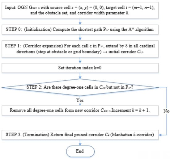
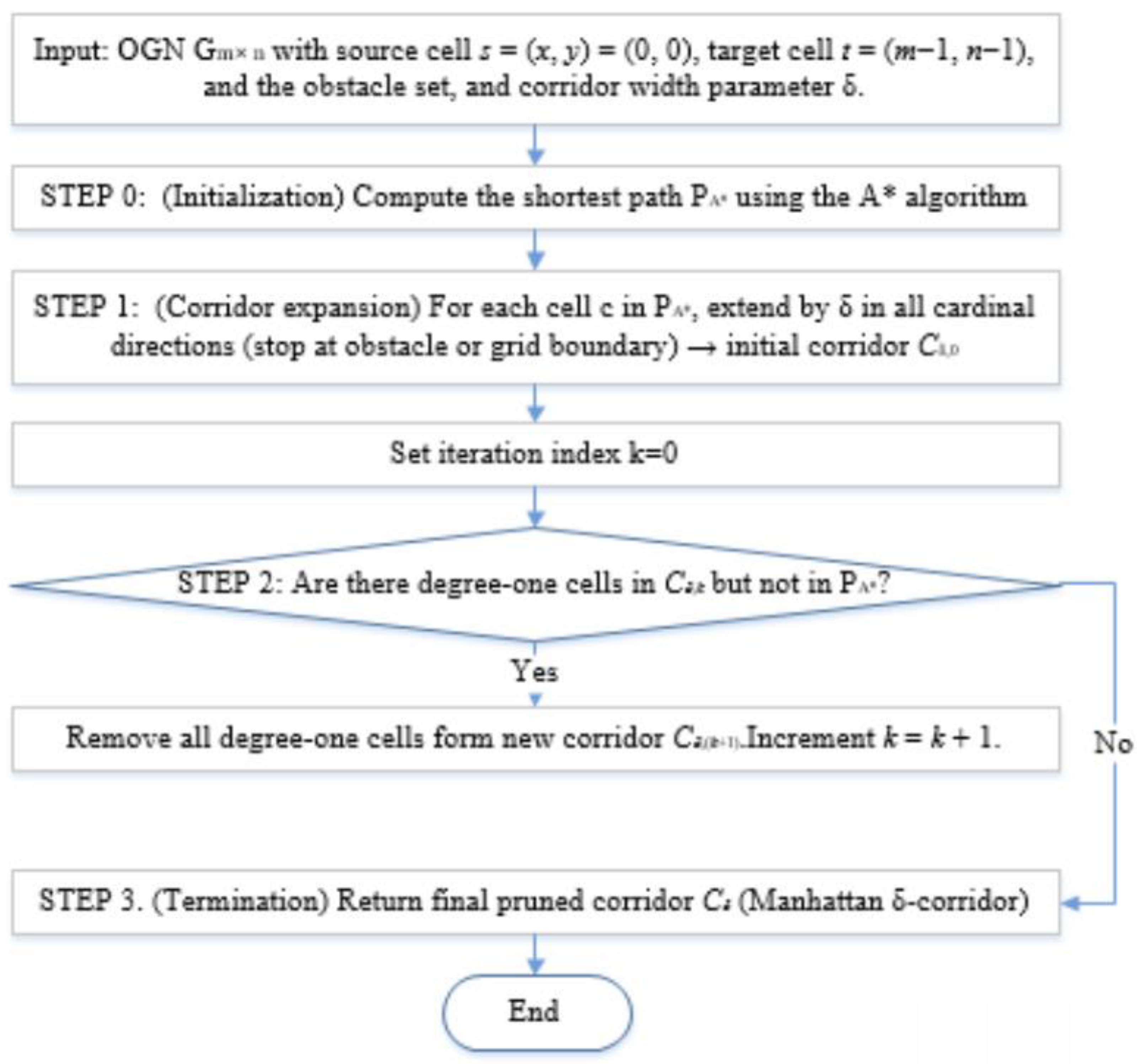
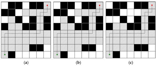
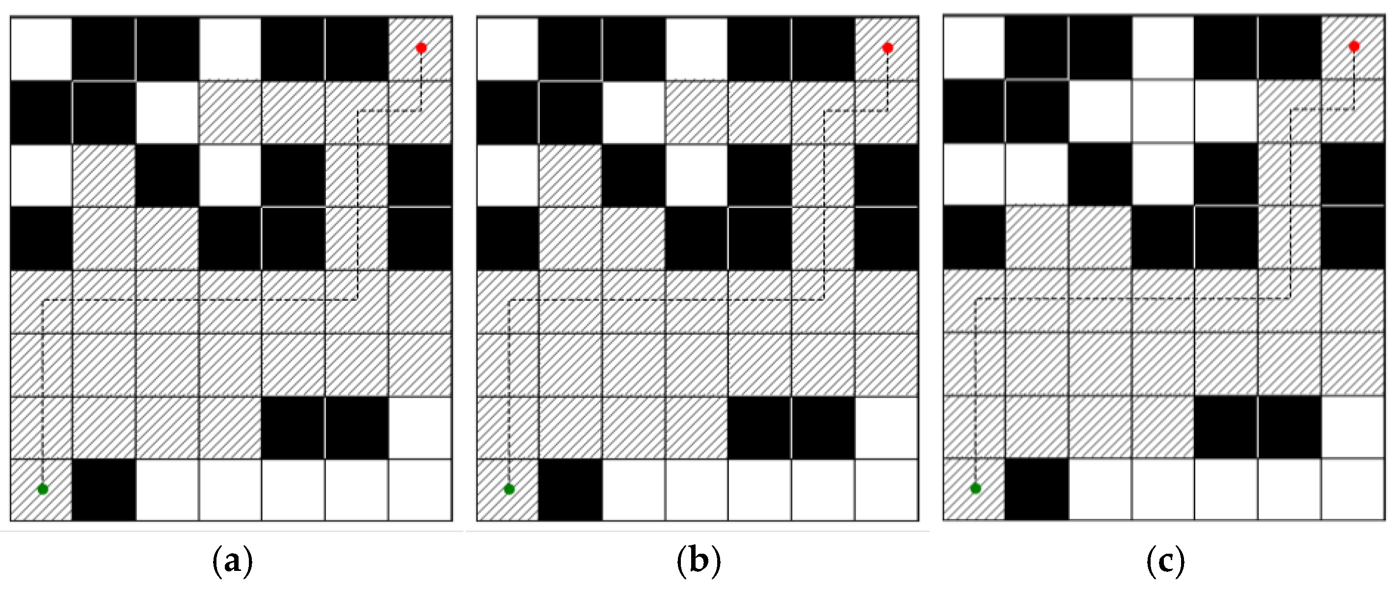
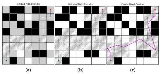
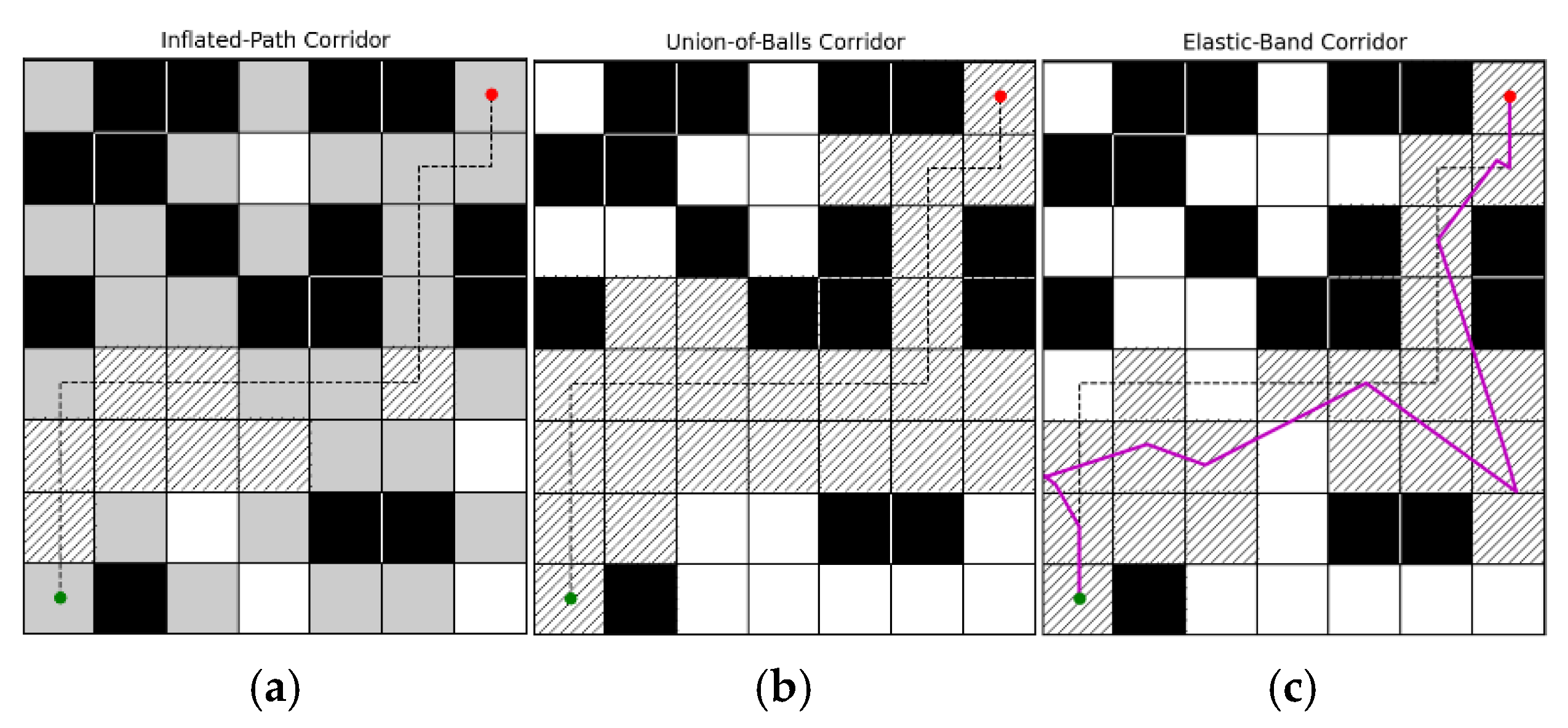
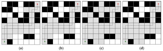
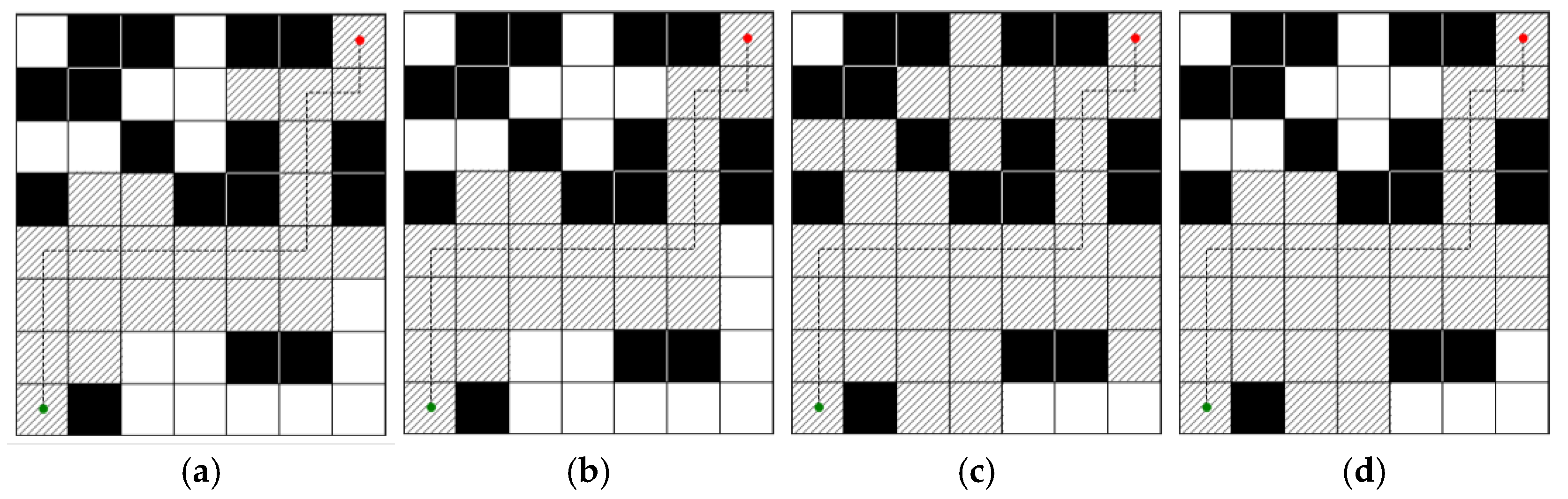
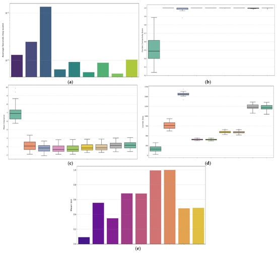
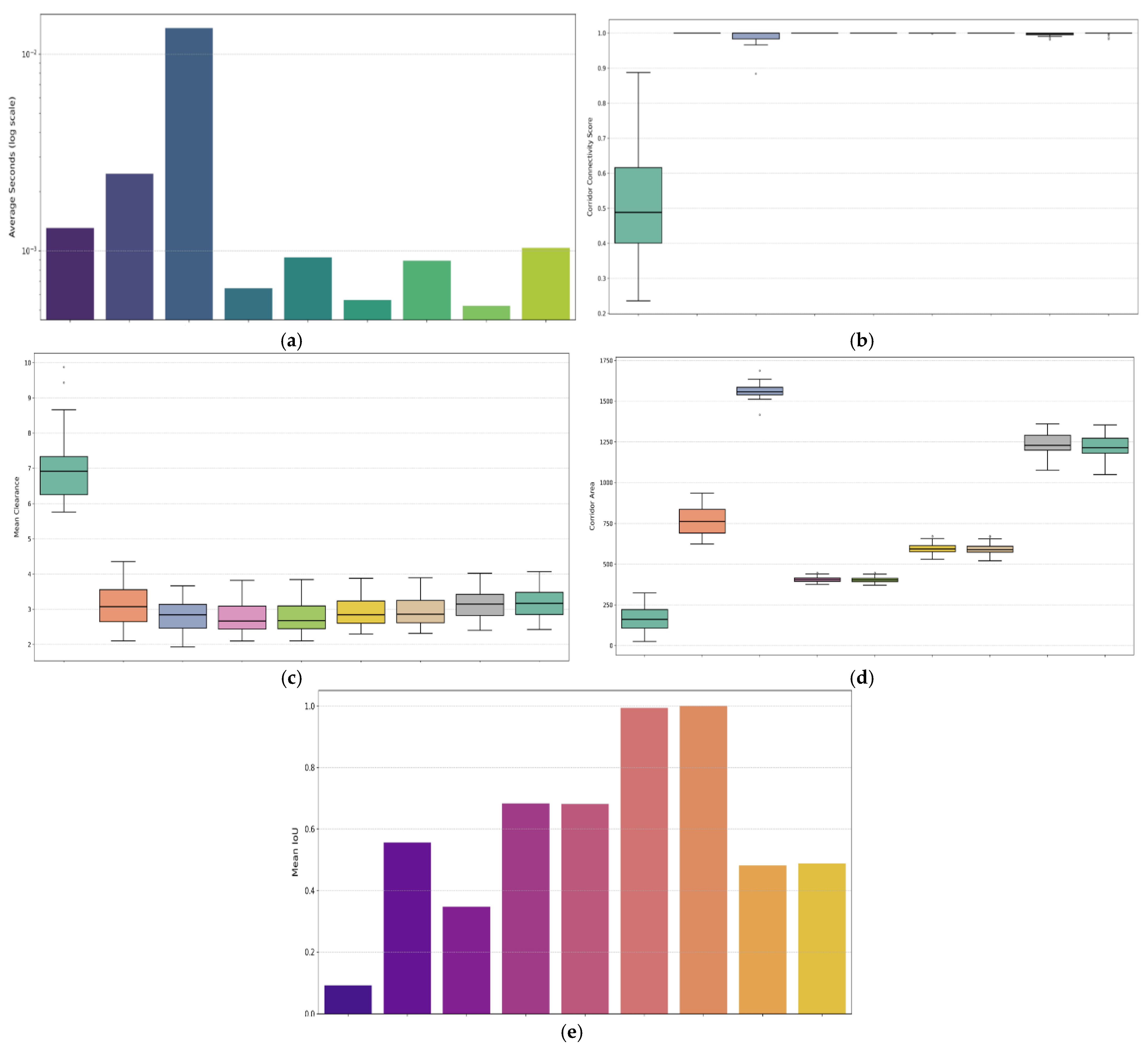
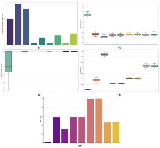
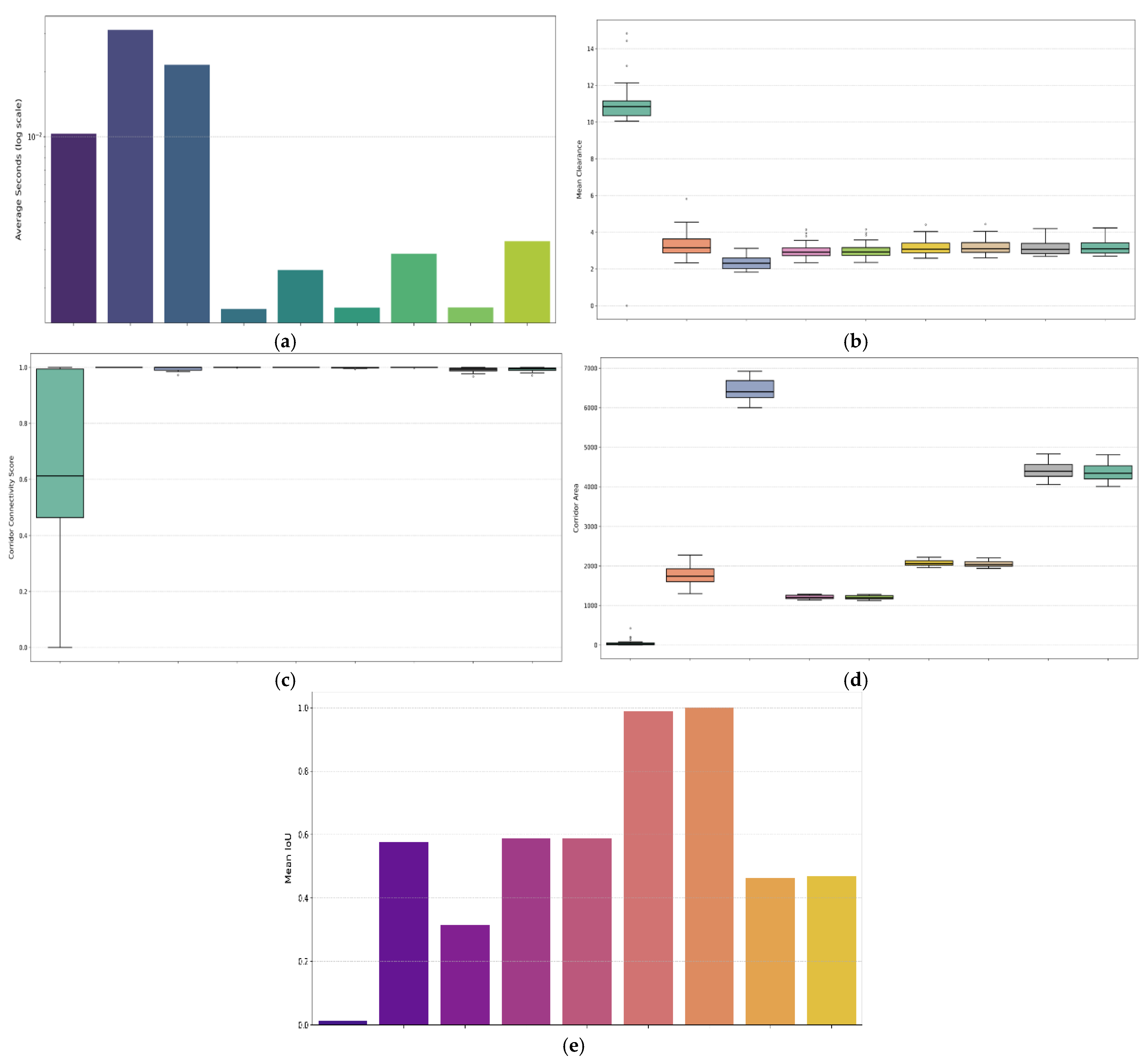
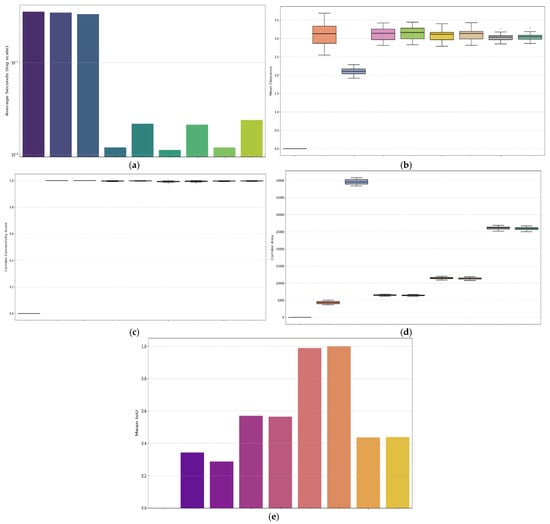
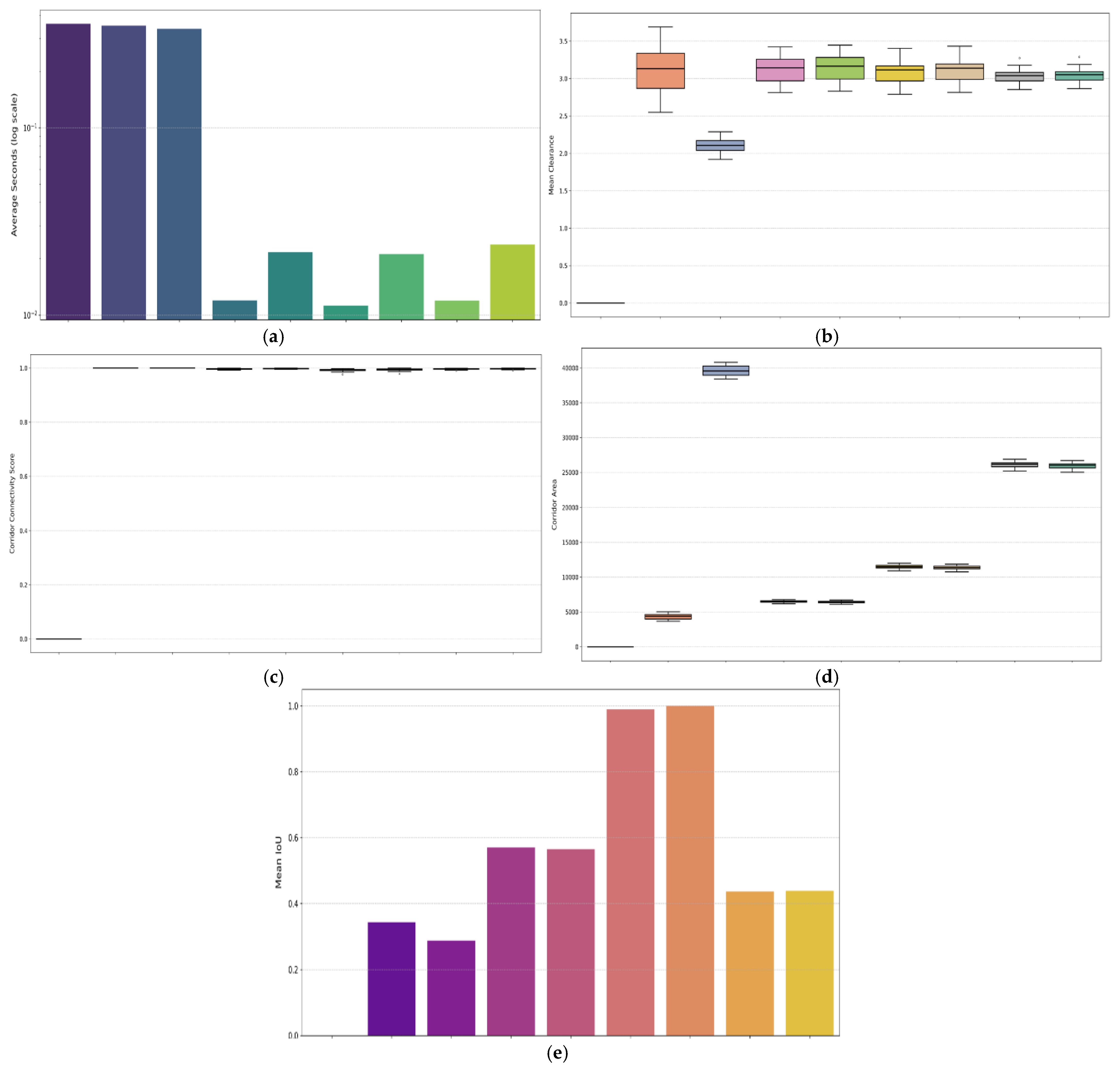
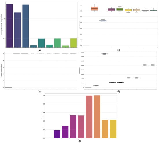
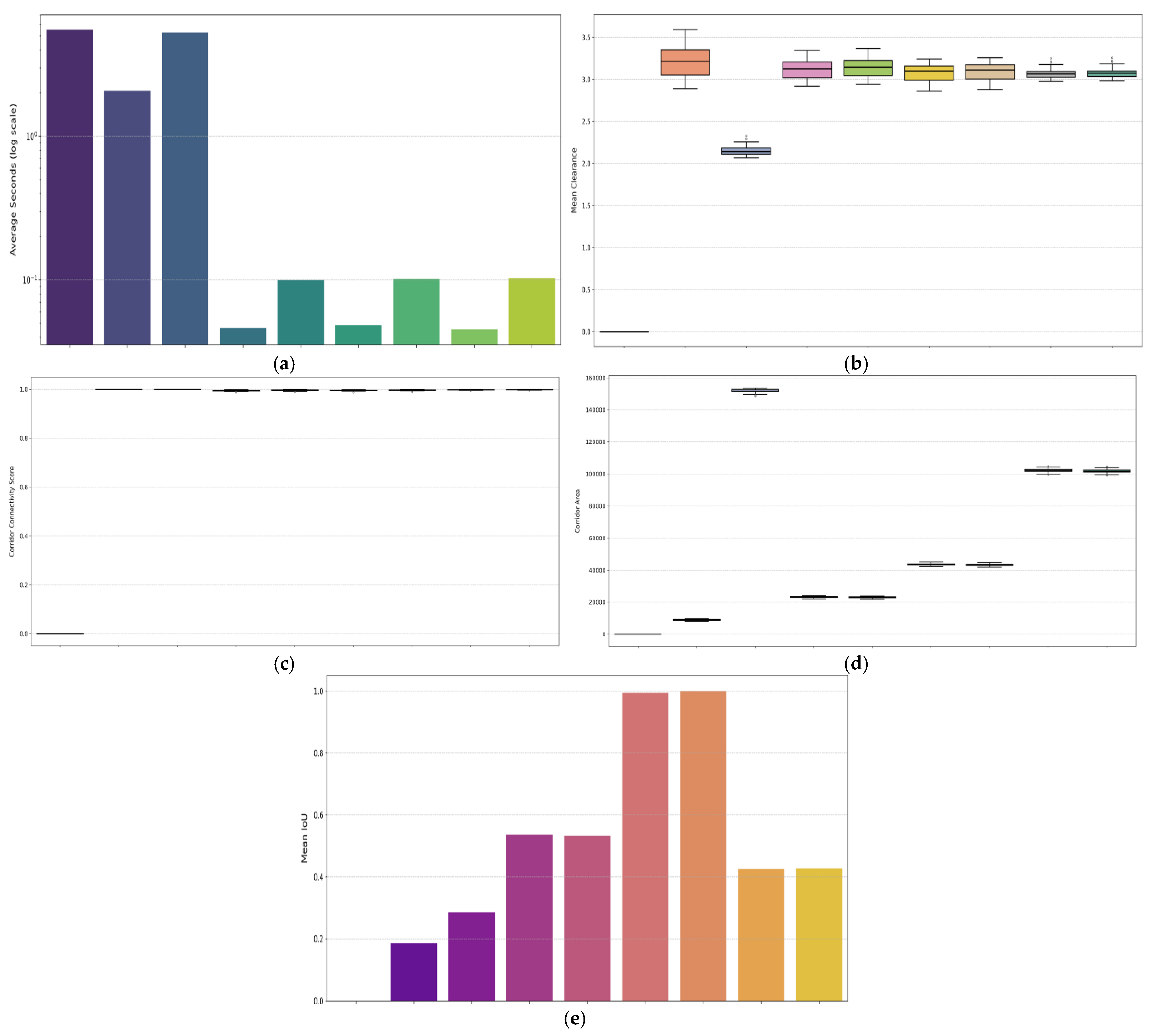

Disclaimer/Publisher’s Note: The statements, opinions and data contained in all publications are solely those of the individual author(s) and contributor(s) and not of MDPI and/or the editor(s). MDPI and/or the editor(s) disclaim responsibility for any injury to people or property resulting from any ideas, methods, instructions or products referred to in the content. |
© 2026 by the authors. Licensee MDPI, Basel, Switzerland. This article is an open access article distributed under the terms and conditions of the Creative Commons Attribution (CC BY) license.