Article

Childcare Center Evacuation to Vertical Shelters in a Nankai Trough Tsunami: Models to Predict and Mitigate Risk

1
School of Nursing, Kanazawa Medical University, 1-1 Uchinada, Kahoku 920-0265, Japan
2
Department of Public Health Nursing, Osaka Medical and pharmaceutical University, 7-6 Hachonishimachi, Takatsukishi 569-0095, Japan
3
Division of Nursing, Faculty of Health Science, Institute of Medical, Pharmaceutical and Health Sciences, Kanazawa University, 5-11-80 Kodatsuno, Kanazawa 920-0942, Japan
4
School of Nursing, Faculty of Medicine, Fukuoka University, 7-45-1 Nanakuma, Jonan-ku, Fukuoka 814-0180, Japan
*
Author to whom correspondence should be addressed.
Challenges 2022, 13(2), 48; https://doi.org/10.3390/challe13020048
Submission received: 24 August 2022 / Revised: 21 September 2022 / Accepted: 28 September 2022 / Published: 30 September 2022

Abstract

:
Following the Great East Japan Earthquake, vertical evacuation shelters (VES) were constructed to reduce tsunami risk. Childcare centers (CCs) in the inundation area are required to evacuate to the nearest VES in the event of a tsunami. The study aim was to identify CCs and VES predicted to be inundated by a Nankai Trough earthquake-generated tsunami, and to clarify CC inundation risk. We identified 52 (45.6%) CCs in the tsunami inundation area and found that 14 (25.9%) would evacuate toward the tsunami. If the walking speed was 2.24 km/h and a 0.3 m tsunami arrived in 10 min, nine (17.3%) CCs would be late to safe evacuation. If the tsunami arrival time was 20 min, four (7.7%) CCs would have late evacuation. At a walking speed of 1.00 km/h, 38 (73.1%) and 20 (38.5%) CCs would have late evacuation, with tsunami arrival times of 10 min and 20 min, respectively. Evacuation direction is important in avoiding tsunami damage. An evacuation strategy is needed that evacuates people away from the tsunami, and takes into account children’s age, walking speed, and evacuation method. The evaluation of tsunami risk in this study may support the development of tsunami countermeasures in other coastal areas with latent tsunami risks.

1. Introduction

In 2011, a tsunami generated by the Great East Japan Earthquake led to more than 23,000 human casualties in Japan [1]. Hori et al. predicted that a Nankai Trough earthquake will occur in the 2030s and will be as large as the 1845 Ansei Nankai earthquake [2]. The Japanese government is asking local governments to develop measures against a possible tsunami generated by a Nankai Trough earthquake. Tsunami disaster countermeasures are an important issue for cities on the Pacific coast that are expected to experience damage from a Nankai Trough earthquake in the near future. Kochi City faces the Pacific Ocean and has a population of approximately 323,000. Approximately 47% of the population of Kochi Prefecture is concentrated in Kochi City [3]. If a Nankai Trough earthquake occurs, the tsunami may reach a height of 16 m and is expected to cause long-term flooding of approximately 2800 hectares [4]. Since the Great East Japan Earthquake in 2011, some buildings have been designated as emergency evacuation sites in the event of a tsunami, in case it is not possible to evacuate to outside the flooded area [5]. On the coast, local governments are building tsunami evacuation towers (TETs) as refuges for individuals unable to quickly escape the flooded area [6].
In Japan, childcare centers (CCs) care for children aged 0–6 years. The Child Welfare Act requires CCs in Japan to conduct evacuation drills once a month [7]. A study of evacuation behaviors during the Great East Japan Earthquake found that children aged 3–5 years were instructed to walk side by side under the guidance of a teacher, and children aged 0–2 years were carried piggyback or in strollers for multiple passengers. Local support for evacuation was also provided [8]. Analysis by Akizuki et al. of evacuation behaviors during the Great East Japan Earthquake suggested that during tsunamis, it is impossible to prevent local residents from trying to save children in CCs, even though residents know they are at risk from the tsunami. Therefore, CCs should be located higher than the tsunami flood levels [9]. In the areas affected by the tsunami caused by the Great East Japan Earthquake, construction work is being carried out to raise the land and residents are moving to higher ground. However, there are many residents and CCs in areas that were not affected by the Great East Japan Earthquake but that are predicted to be affected by tsunamis.
Iwate, Miyagi, and Fukushima were severely damaged by the Great East Japan Earthquake. There were 15,876 victims in total one year after the disaster, of whom 466 were 0–9 years old. In this disaster, most of the children affected were in schools and childcare facilities [10]. It is speculated that it was particularly difficult to evacuate toddlers, who walk slowly. The impact on children who survived the tsunami is also serious. Many had post-traumatic stress disorder and depressive symptoms after the tsunami [11,12], and felt guilty that they had survived [13]. The effect of the tsunami disaster on children was therefore complex.
To enable children in CCs to quickly evacuate in the event of an earthquake-generated tsunami, it is necessary to identify the nearest non-flooded area and the shortest route to that location, and to formulate a carefully considered evacuation strategy. Above all, it is important that CCs near the coast have tsunami evacuation strategies to save children’s lives and avoid damage to the CC. There have been reports of tsunamis caused by earthquakes around the world. When a tsunami occurs, the epicenter is important, but tsunami damage is not limited to the immediate location or by the size of the earthquake. The rise in sea level due to global warming and urban development in low-lying coastal areas both have effects [14,15]. Tsunami evacuation strategies for CCs, where children spend long hours during the day, should be considered in all coastal areas of the world.
To develop evacuation measures for a Nankai Trough earthquake-generated tsunami, several researchers have conducted agent-based modeling and simulation of tsunami evacuation. In 2020, Muhammad et al. evaluated the evacuation plan for Saga City, Kochi Prefecture, and highlighted the necessity of vertical evacuation shelters (VES) and the importance of evacuation speed [16]. Assuming that vulnerable people will evacuate by car, Takabatake et al. conducted a simulation of pedestrian and car evacuation. They found that shelter location and route selection are important for successful evacuation [17]. Kondo has estimated that approximately 46,000 people would be killed even if TETs and tsunami evacuation buildings (TEBs) were constructed, and suggested that in the event of a Nankai Trough earthquake, residents should relocate to higher ground [18]. Geographic information system (GIS) network analysis tools help to determine the reachable range of optimal evacuation sites, evacuation routes, and walking speeds.
There is considerable research on tsunami damage assessment and evacuation using GIS, including traffic flow simulations from a tsunami hazard zone by Wood et al. [19]. According to Kubisch et al., in the event of a tsunami, approximately 40% of the population of Talcahuano, Chile, would not be able to reach the evacuation range even if their walking speed increased [20]. Therefore, walking speed is an important evacuation factor because of delays owing to traffic jams and the destruction of infrastructure. In one study of the Cilacap coastal area of Indonesia, ArcGIS network analysis was used to locate the nearest evacuation shelter buildings, taking into account road conditions and walking speed [21]. In addition, GIS network analysis has been used to search for optimal tsunami evacuation routes and service areas. For example, Sutikno et al. used GIS network analysis to identify appropriate evacuation routes and shelter allocation during a possible earthquake in Pacitan City, Indonesia [22], and Sutikno and Murakami evaluated access to shelters in Indonesia to identify shelters that could not be reached in the event of a tsunami [23]. Kumagai et al. calculated the walking distance from evacuation centers based on lessons learned from the Great Hanshin-Awaji earthquake, and estimated the number of evacuees in each area [24]. We previously assessed the effectiveness of the installation of guide signs to evacuate hearing-impaired people from a tsunami [25]. A previous study on risk assessment for hurricanes examined the suitability of existing shelters and the construction of a model to determine the placement of shelters [26]. Bagewadi et al. used GIS to evaluate and visualize the vulnerabilities in each district in Mumbai, India [27], and Ye et al. used GIS to analyze evacuation demand, access, and optimal evacuation destinations in Shanghai, China, in preparation for an earthquake [28]. In a 2016 study, a tsunami risk map was generated that combined a vulnerability map and an evacuation resilience map to identify important tsunami resources [29].
The walking speed of evacuees is important in timely tsunami evacuation [30]. CCs care for children aged 0–6 years, and the speed of evacuation varies according to the age of evacuees. However, no studies have examined the route to the nearest VES in the event of a tsunami caused by a Nankai Trough earthquake, taking into account the walking speed of children. In this study, we identified the CCs and TEBs/TETs (TETs are VES) in Kochi City that are predicted to be flooded by a tsunami caused by a Nankai Trough earthquake. VES capacity, hierarchy, evacuation environment, CC capacity, and inundation depth were determined. Furthermore, taking into account walking speed and tsunami arrival time, we estimated the number of people who would be late in evacuating to the nearest VES. In recent years, attempts have been made to estimate mortality risks from tsunamis on a global scale [31]. The evaluation of tsunami risk in areas likely to be affected by tsunamis from Nankai Trough earthquakes may help in developing tsunami countermeasures in other coastal areas with latent tsunami risks.

2. Materials and Methods

2.1. Terms Used in This Study

  • Tsunami Evacuation Buildings (TEBs)
These are buildings used for temporary evacuation in the event of a tsunami. For example, condominiums and office buildings are designated as TEBs by the local government in normal times and published on a website [24].
  • Tsunami Evacuation Towers (TETs)
These buildings are located in coastal areas where tsunami evacuation is difficult. The towers are used for temporary evacuation from the tsunami [25].
  • Vertical Evacuation Shelters (VES)
Taking into account the ground subsidence caused by the earthquake and the height of the tsunami, four-story TEBs and TETs or above are defined as VES.
  • Inundation Depth
In this study, we use the term inundation depth, also termed flow depth in some studies, to refer to the depth at which the (usually dry) ground is covered with water by the tsunami. The flow and approach direction of tsunamis are not considered [32]. In Japan, local governments use hazard maps to indicate the depth of inundation caused by tsunamis and call on residents to evacuate early [33].
  • Late Evacuation
We use the term “late evacuation” to refer to instances when our model indicates that CCs would not be able to reach safety in the estimated time available to them.

2.2. Types and Sources of Data Used for Analysis

Types and Sources of Data Used for Analysis are shown in Table 1.

2.3. Data Collection
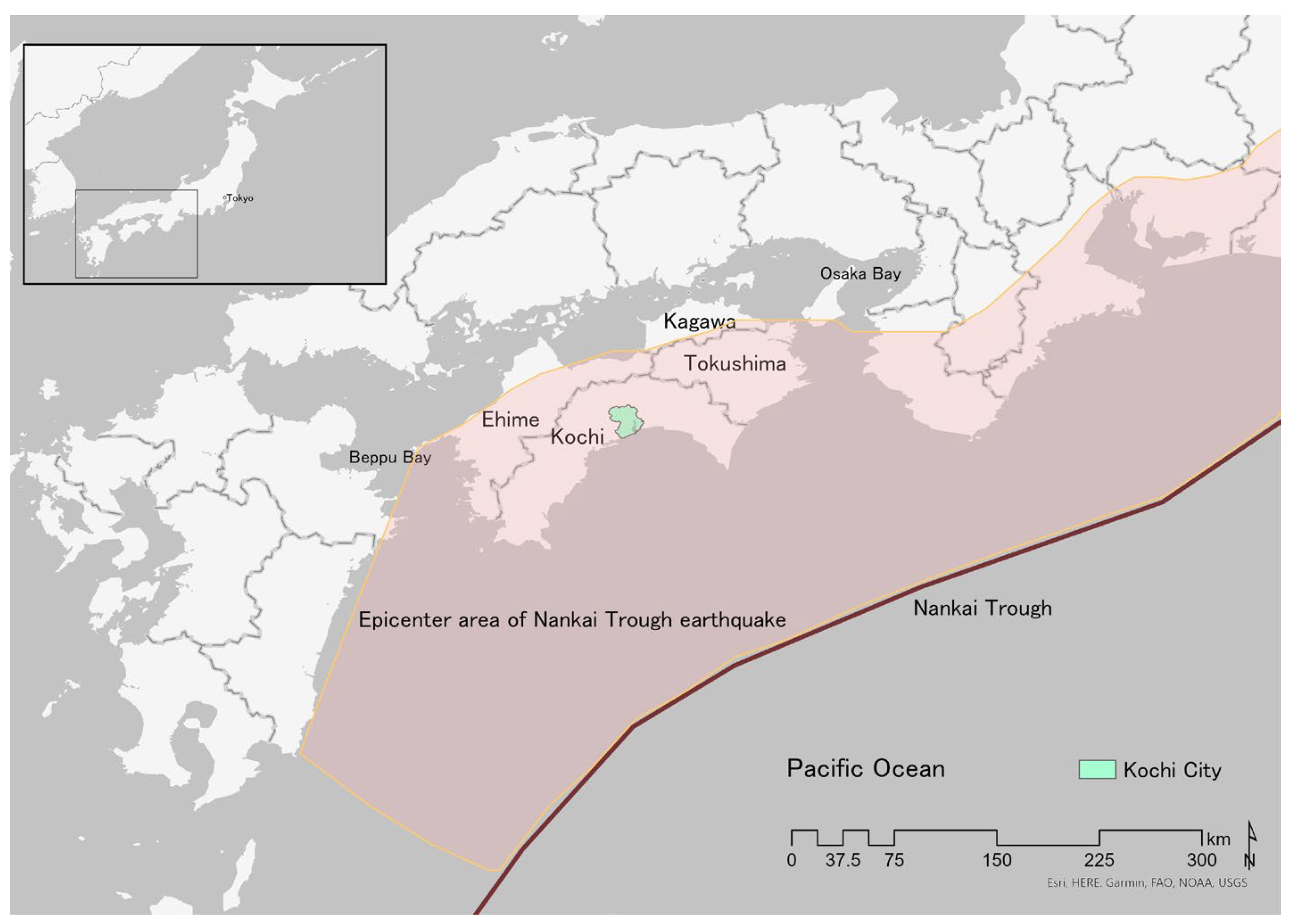
We obtained a TEB list, a TET list, and a CC list from the Kochi City website [5,34,35]. To identify the CCs in the tsunami inundation area of Kochi City, we obtained polygon data of the tsunami inundation area from the website of the Ministry of Land, Infrastructure, Transport, and Tourism [36].

2.4. Target Area

The target city is Kochi City, Kochi Prefecture, in the Shikoku region of Japan. Kochi City is located on the Pacific coast and has a population of 324,191 (Figure 1) [37]. A Nankai Trough earthquake may have a seismic intensity of 7 in the area between Shizuoka Prefecture and Miyazaki Prefecture, and will likely cause a large tsunami of 10 m or more [38,39]. The Nankai Trough has an average depth of 4000 m and a depth of 150–200 km off the coast of Kochi Prefecture, and has caused several earthquakes of magnitude of 8 or more at intervals of approximately 100 years [38]. If a Nankai Trough earthquake occurred, it is estimated that the ground in Kochi City would subside 1.5 m and approximately 2800 hectares of land would be inundated for a long time [4].

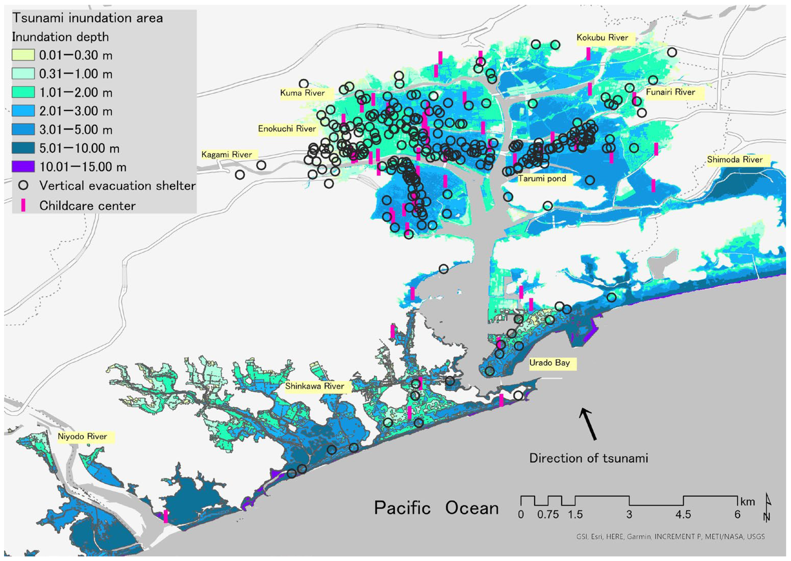
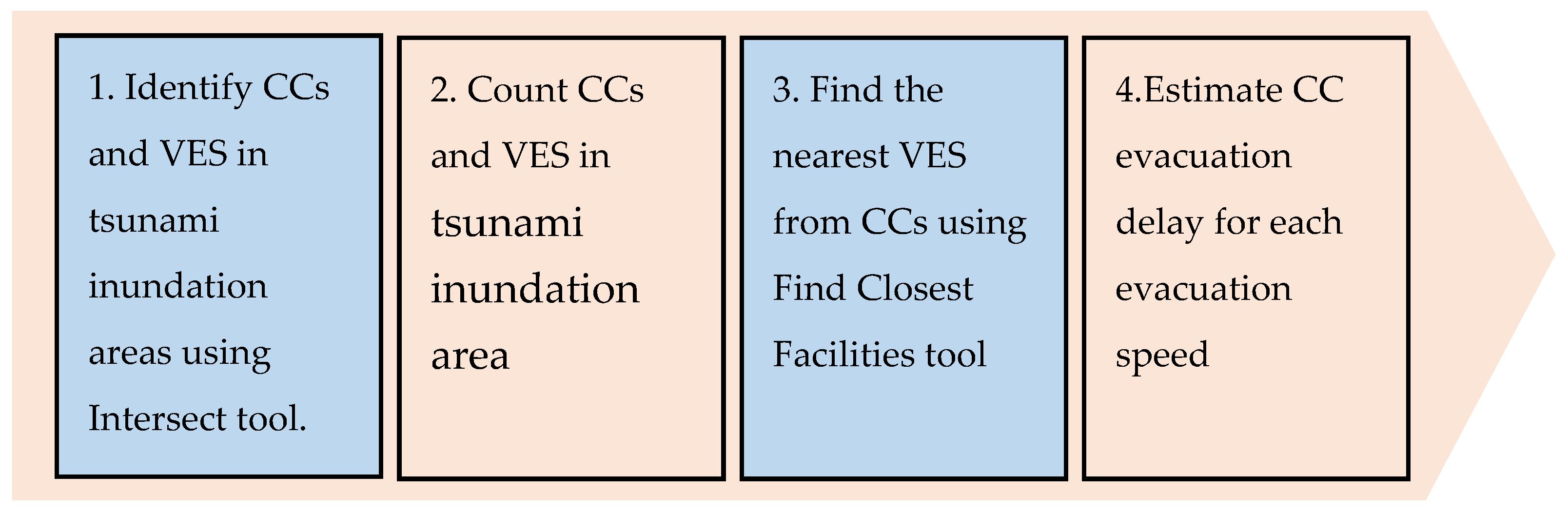
2.5. Location of Vertical Evacuation Shelters (VES) and CCs in Tsunami Inundation Area

We counted the number of TEBs and TETs in Kochi City. For TEBs, we calculated the building hierarchy, the evacuee capacity, and the distribution of locations in flooded areas. We used GIS to plot CCs, TEBs, and TETs on the map to depict the tsunami inundation area. We used the Intersect tool to identify CCs in the tsunami inundation area. We calculated the inundation depth, total capacity, and median of CCs in the tsunami inundation area. Figure 2 shows the CCs and VES in the tsunami inundation area of Kochi City.

2.6. Analysis of Disaster Risk Taking into Account Walking Speed and Tsunami Arrival Time

Using the Find Closest Facilities tool in Arc GIS Pro, we identified pedestrian routes from each CC to the nearest VES. Assuming that the tsunami flows from the coast to the mountains, we visually confirmed the movement path of each CC and the direction of the tsunami inflow from the coastal area, and simply counted the CCs moving toward the tsunami. It should be noted that the direction of evacuation is determined based on visual observation and the results are approximate. For this search, bridges over bays, rivers, and ponds were set to be closed (specifically, Urado Bay, Niyodo River, Shinkawa River, Kagami River, Enokuchi River, Kokubu River, Kuma River, Funairi River, Shimoda River, and Tarumi pond). Walking speed was set as the average speed when evacuating from the Great East Japan Earthquake tsunami toward a hill on foot. The speed of individuals with a companion who had difficulty walking was 1.88 km, and the speed of those accompanied by elderly people and infants was 1.66 km. The baseline travel speed was set as an average value of 2.24 km, assuming that the pedestrian had a stroller and was walking on flat ground [42]. However, there are some limitations to setting a baseline value for travel speed. Walking speed varies according to the child’s age and physical strength, and the number of strollers available. Walking speed also varies according to the person carrying the child.
We calculated the distance from each CC to the nearest VES, the median (range) walking time, and the number and percentage of CCs that would evacuate toward the tsunami. With reference to the Kochi Prefecture Disaster Prevention Map [43], we calculated the number and percentage of CCs that are not expected to evacuate within the time it takes for a 0.3 m tsunami to reach them. Kochi Prefecture has published a map of the arrival time of a 0.3 m tsunami, which states that it will be impossible for residents to evacuate on foot and asks residents to evacuate quickly [33]. However, setting the arrival time of a 0.3 m tsunami has important limitations. It does not consider the damage risk until the tsunami reaches 0.3 m. Therefore, it should be noted that there is a risk of disaster before reaching 0.3 m of inundation, and a tsunami may go on to have flow depths that greatly exceed 0.3 m. For GIS analysis, ArcGIS Pro 2.8.0 from Esri (California, CA, USA) was used.

2.7. Estimated Number of CCs Expected to Have Late Evacuation Times for Each Walking Speed

We estimated the number of CCs expected to have late evacuation times at each walking speed. The baseline walking speed was set at 2.24 km/h, a slow walking speed scenario was set at 1.00 km/h or 2.00 km/h, and a fast walking speed scenario was set at 3.00 km/h, 4.00 km/h, or 5.00 km/h.
The analysis flow is shown in Figure 3.

3. Results

3.1. VES Breakdown and Capacity, Building Hierarchy, and Evacuation Site Environment

The median TEB capacity is 302, with a range of 8 to 71,645. The median number of building stories is five (range: 1–22 stories). Table 2 shows a breakdown of VES building hierarchy and evacuation site environment.

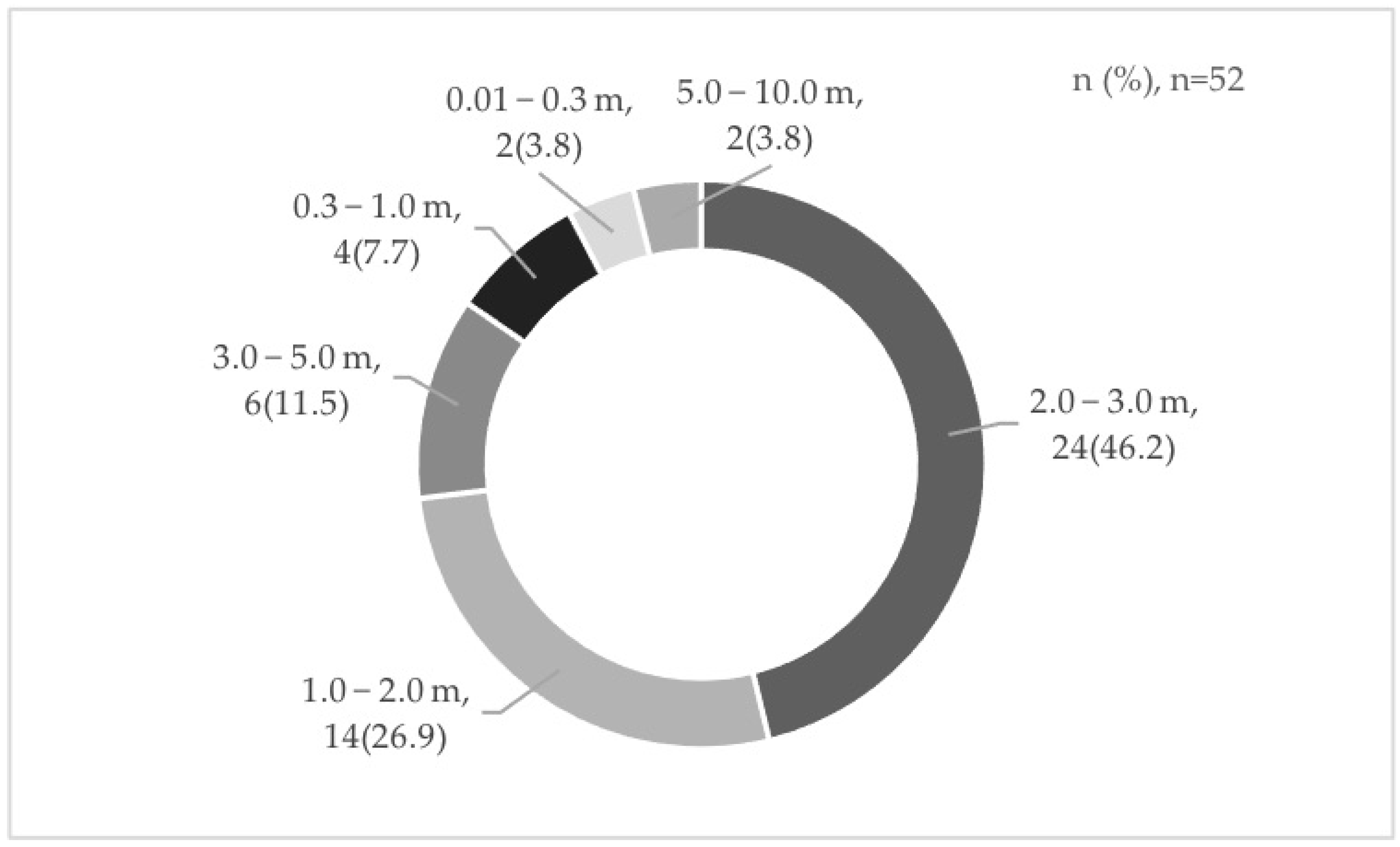
3.2. CCs in Tsunami Inundation Area (n = 114)

Kochi City has 114 CCs, with a total capacity of 5531 people, a median of 101 people, and a capacity range of 20 to 265 people. Of CCs, 52 (45.6%) are in areas where tsunami inundation is expected. Figure 4 shows the number of CCs for each inundation depth.

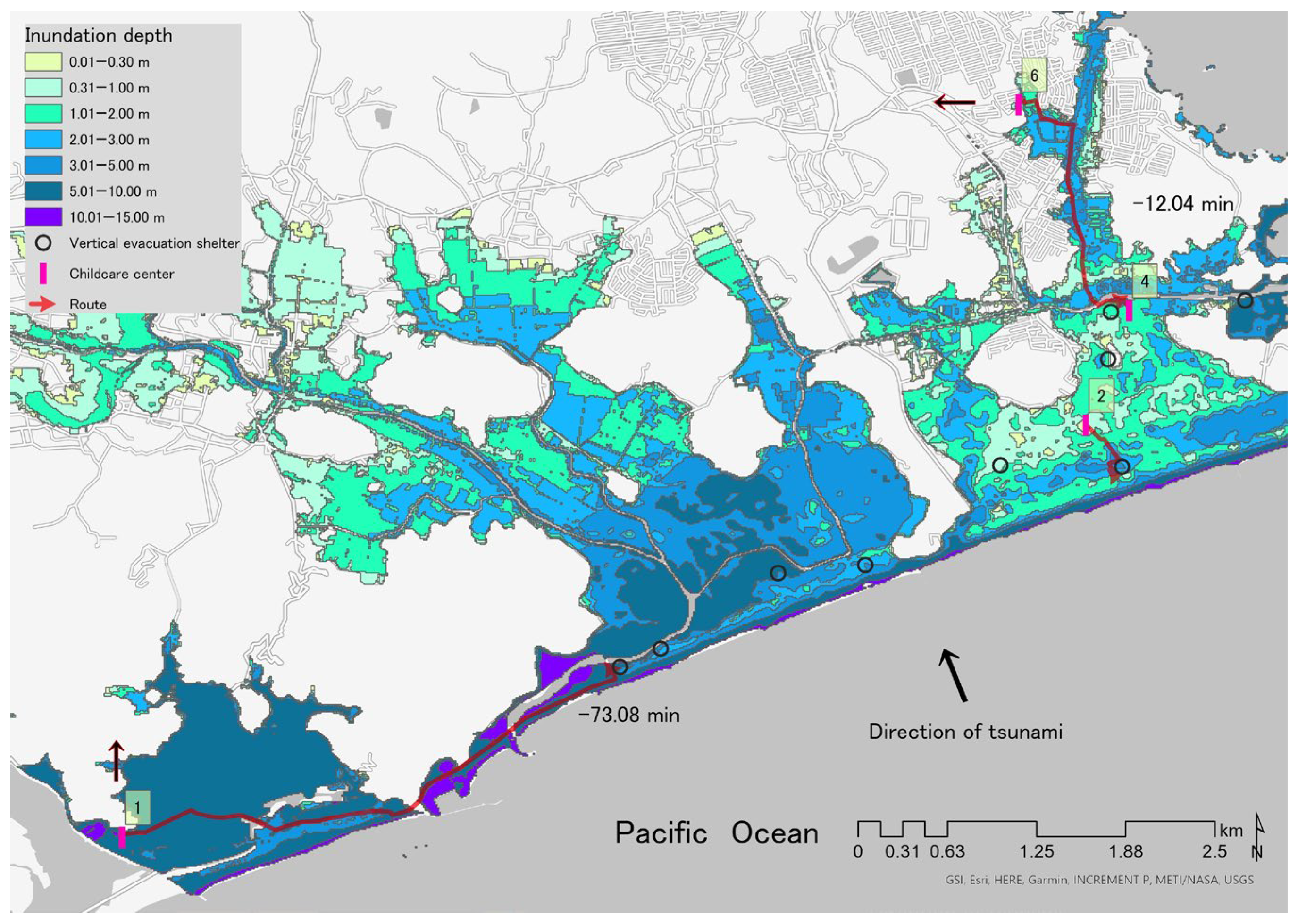
3.3. Route Analysis from CCs in the Inundation Area to Nearest VES Using the Find Closest Facilities Tool

In the event of a tsunami, if a person walked at 2.24 km/h and evacuated to the nearest VES, the median evacuation distance would be 0.24 km and the range would be 0 to 3.47 km. The median walking time would be 6.32 min and the range would be 0 to 93.08 min. If the CCs moved toward the nearest VES, 14 CCs (25.9%) would evacuate toward the tsunami inflow and two CCs (3.8%) would not reach the VES by the time a 0.3 m tsunami arrived. If the walking time is subtracted from the tsunami arrival time, two CCs would have late evacuations (shown by negative values): ID1 (−73.08 min) and ID6 (−12.04 min). ID1 and ID6 would be able to evacuate quickly from the flooded area by moving toward the inflow direction of the tsunami instead of moving to the nearest VES (Figure 5). If they evacuated toward the nearest VES, the following CCs would move toward the coast (their Euclidean distances from the coast are shown in parentheses): ID2 (approximately 527 m), ID3 (approximately 131 m), and ID7 (approximately 835 m) (Figure 6).

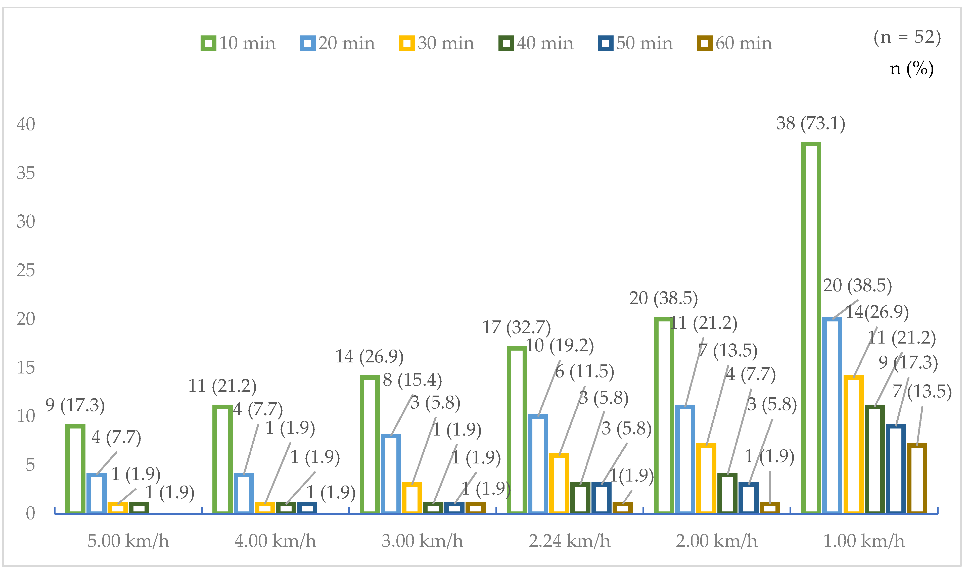
3.4. Estimation of CCs That Could Not Evacuate Using Walking Speed and Tsunami Arrival Time

Figure 7 shows the estimated number of late evacuations for each tsunami arrival time according to differences in walking speed. If a 0.3 m tsunami arrived in 10 min, assuming a base walking speed of 2.24 km/h, 17 CCs (32.7%) would have late evacuations. The number of late evacuations for speeds faster than the base walking speed would be 14 CCs (26.9%) at 3.0 km/h, 11 CCs (21.2%) at 4.0 km/h, and 9 CCs (17.3%) at 5.0 km/h. The number of late evacuations for speeds slower than base walking speed would be 20 CCs (38.5%) at 2.0 km/h and 38 CCs (73.1%) at 1.0 km/h.

4. Discussion

In the event of a tsunami caused by a Nankai Trough earthquake, approximately 14% of VES may be damaged from land subsidence because of insufficient building height. Findings from the 2011 Great East Japan Earthquake emphasize the need for VES that are high enough to withstand the estimated tsunami height [44]. Land subsidence has occurred in Kochi Prefecture as a result of a previous Nankai Trough earthquake [45]. During the Nankai Trough earthquake of 1946, land subsidence of approximately 1 m occurred, and it took approximately a month for the seawater to completely disappear [38]. The designation of three-story buildings and below as VES should be carefully considered because of land subsidence. We recommend that policy makers review VES designation taking into account land subsidence caused by a Nankai Trough earthquake.
A tsunami often causes long-term inundation of low-lying land [46]. There are concerns about long-term inundation of the plains in Kochi Prefecture in the event of a Nankai Trough earthquake and tsunami [47]. During the tsunami caused by the Great East Japan Earthquake, some people evacuated to the roofs of school buildings; they had to wait until the next morning for helicopters to arrive [48]. Data from Kochi Prefecture estimate that approximately 130,000 people will be left behind in VES if a tsunami occurs [47]. People who evacuate to VES must expect to wait tens of hours for helicopter rescue. Because 18.8% of VES evacuation sites are outdoors, some evacuees may become ill from exposure to heat or cold. Policy makers need to develop policies that take into account VES capacity, rescue time, and the effect of climate on evacuees’ physical condition. Specifically, it is recommended that outdoor VES be insulated from the heat and cold and be equipped with drinking water and an emergency battery, because people may have to remain outdoors for some time after evacuation.
It has been noted that the use of TETs in areas near the coast of Japan may increase casualties by directing evacuees living on higher land to evacuate to TETs on lower land that are at higher risk of flooding [49]. The route analysis using the Find Closest Facilities tool showed that if people evacuate from CCs to the nearest VES, 25.9% will move toward the tsunami. Simply instructing people in CCs to evacuate to the nearest VES is not enough to avoid damage from the tsunami. If ID2 and ID7 in the coastal area move to the nearest VES, they would be moving toward the tsunami. ID3 would also move toward the tsunami, then bypass the coast and move out of the flooded area to the hill. ID2, ID7, and ID3 could evacuate from the flooded area faster by moving toward the tsunami than by moving to the nearest VES (Figure 6). People in areas near the coast do not have time to wait for warnings from the authorities. It has been pointed out that people should act immediately after ascertaining that an earthquake has hit [50]. When developing a coastal CC evacuation plan, it is important to consider the tsunami arrival time at the evacuation route, the direction of the tsunami, and the distance to the land outside the flooded area to determine if evacuation to the nearest TET is optimal. CC evacuation behavior should differ according to the age of the children. Children aged 3–5 years tend to be instructed to walk two abreast under the guidance of teachers, and children aged 0–2 years tend to be carried piggyback or transported in multi-passenger baby strollers [8]. This means that children aged 3–5 years and their teachers must evacuate at the walking speed of a 3-year-old. According to the Ministry of Health, Labor, and Welfare, CC evacuation drills show that the walking speed of a 3-year-old child is approximately 1.0 m/s (3.6 km/h) [51]. Taking into account the child’s physical strength and walking endurance, future evacuation plans must assume a walking speed slower than 3.6 km/h. Geographic least-cost distance modeling, which incorporates time-variable exposure, distributed travel speeds, and uncertain evacuation departure time, shows that evacuation departure time has a large effect on total evacuation time [52].
In recent years, the importance of risk reduction in disaster risk management has been highlighted [53,54]. After the Great East Japan Earthquake, Japan implemented a program of TEB designation and TET construction in tsunami inundation areas to reduce risk from tsunamis [55]. The main implications of our findings for CC disaster risk management are that TEB designation, TET construction, and evacuation requests do not reduce risk sufficiently. CC geographic features, tsunami arrival times, walking speeds, and evacuation directions should also be considered to prevent child casualties. Several real and hypothetical tsunami evacuations by Chen et al. [56] show significant delays in departure times. CCs require more evacuation time than institutions with adults, and further research on the evacuation preparation time of nursery schools is necessary. We suggest that such considerations be applied not only to CCs but also more generally in areas of expected tsunami inundation.
This study has some limitations. The present study did not consider the time from the occurrence of the earthquake to the evacuation departure time. Because the time required for departure may vary depending on the age and condition of the child, a more elaborate evacuation strategy is required that takes into account children’s age and condition. Incorporation of departure delays would produce higher estimates of fatalities and thus, further research is needed to assess departure time delays for CCs. In the ArcGIS Pro Find Closest Facilities analysis, the tsunami arrival time was set at 0.3 m. This inundation depth simply indicates the height of inundation from the ground surface. It does not consider the direction of the tsunami, the flow speed, or the effects of slope and terrain. Furthermore, depending on children’s body shape and walking speed, it is highly possible that children will be unable to evacuate owing to flooding of several cm. We did not consider the time between the occurrence of the earthquake and the start of evacuation. In calculating the difference between the time required for evacuation and the tsunami arrival time, the time taken for the tsunami to reach CCs was calculated, but the time taken for the tsunami to reach the evacuation route was not taken into account. Formulating a CC evacuation plan requires interviews with CC managers about planned evacuation routes and a detailed analysis that includes all additional factors. However, earthquakes occur around the world. This model may also be useful for developing tsunami evacuation plans that match the actual conditions of coastal areas elsewhere.

5. Conclusions

VES need to be well provisioned, and it is also important to take into account evacuation direction, walking speed, and the tsunami arrival time at the evacuation route to prevent late CC evacuation. CCs exposed to short tsunami arrival times should consider relocating to higher ground or, if that is not possible, installing a TET adjacent to the CC. The TEB designation for three-story buildings and below should be reviewed to take into account the land subsidence caused by a Nankai Trough earthquake.

Author Contributions

Conceptualization, H.N. and R.H.; Methodology, H.N., R.H. and Y.M.; Formal analysis, H.N.; Investigation, H.N.; Resources, H.N.; Data curation, H.N.; Writing—original draft preparation, H.N.; Writing—review and editing, H.N., R.H., T.I. and Y.M.; Visualization, H.N. and T.I.; Supervision, H.N.; Project administration, H.N.; Funding acquisition, H.N. All authors have read and agreed to the published version of the manuscript.

Funding

This research was funded by JSPS KAKENHI grants numbers [17K12185, 20H04027]. The sponsors had no role in the design, execution, interpretation, or writing of the study.

Data Availability Statement

Information about the addresses and capacity of CCs in Kochi City can be found on the Kochi City Website, List of Childcare Centers in Kochi City 2021 (https://www.city.kochi.kochi.jp/soshiki/34/hoikuyotiitiran.html) accessed on 14 June 2021. Information about the addresses and capacity of TETs can be found on the Kochi City Website, List of Evacuation Sites and Shelters (https://www.city.kochi.kochi.jp/site/bousai/hinanbasyo-hinansyo.html) accessed on 14 June 2021. Information about the addresses and capacity of TEBs and the evacuation environment is published on the Kochi City Website, Tsunami Evacuation Building (https://www.city.kochi.kochi.jp/soshiki/12/tunamihinannbiru.html) accessed on 14 June 2021.

Acknowledgments

We thank Diane Williams for editing a draft of this manuscript.

Conflicts of Interest

The authors declare no conflict of interest.

References

  1. Cabinet Office Summary of Damage: Disaster Prevention Information Page. Available online: http://www.bousai.go.jp/kaigirep/hakusho/h23/bousai2011/html/honbun/1b_1h_1s_2.htm (accessed on 7 September 2021). (In Japanese).
  2. Hori, T. A Statistical Model of Temporal Variation of Seismicity in the Inner Zone of Southwest Japan Related Tote Great Interplate Earthquakes along the Nankai Trough. J. Phys. Earth 1996, 44, 349–356. [Google Scholar] [CrossRef]
  3. Kochi-City Kochi City Population by Region and Age, Kochi City Open Data. Available online: https://www.city.kochi.kochi.jp/soshiki/7/population.html (accessed on 25 September 2021). (In Japanese).
  4. Kochi Prefectural Government Largest Class Nankai Trough Earthquake. Available online: https://www.pref.kochi.lg.jp/sonae-portal/earthquake/tokucho.html (accessed on 7 September 2021). (In Japanese).
  5. Kochi City Kochi City Tsunami Evacuation Building. Available online: https://www.city.kochi.kochi.jp/soshiki/12/tunamihinannbiru.html#tunamihinannbirutoha (accessed on 22 August 2022). (In Japanese).
  6. Cabinet Office Casebook of Tsunami Evacuation Building. Available online: http://www.bousai.go.jp/jishin/tsunami/hinan/pdf/jireishuu.pdf (accessed on 25 September 2021). (In Japanese).
  7. Child Welfare Act Standards for Facilities and Operation of Child Welfare Institution (29 December 1948, Ministry of Health and Welfare Ordinance No. 63). Available online: https://www.mhlw.go.jp/web/t_doc?dataId=82069000&dataType=0&pageNo=1 (accessed on 8 September 2021). (In Japanese).
  8. Pinheiro, A.T.K.; Hokugo, A. Effectiveness of Early Warning and Community Cooperation for Evacuation Preparedness from Mega-Risk Type Coastal Hazard in Childcare Centers. Int. J. Disaster Resil. Built Environ. 2019, 10, 260–275. [Google Scholar] [CrossRef]
  9. Akizuki, Y.; Hokugo, A.; Nishino, T. Research Analysis of The Realistic Evacuation Behaviour from Tsunami and Fire in the Aftermath of The Great East Japan Earthquake 2011. Fire Saf. Sci. 2014, 11, 718–731. [Google Scholar] [CrossRef]
  10. Cabinet Office Section 1, Situation of children in the Great East Japan Earthquake. Available online: https://www8.cao.go.jp/shoushi/shoushika/whitepaper/measures/w-2012/24webhonpen/html/b2_s5_1.html (accessed on 23 August 2022). (In Japanese).
  11. John, P.B.; Russell, S.; Russell, P.S.S. The Prevalence of Posttraumatic Stress Disorder Among Children and Adolescents Affected by Tsunami Disaster in Tamil Nadu. Disaster Manag. Response 2007, 5, 3–7. [Google Scholar] [CrossRef] [PubMed]
  12. Thienkrua, W.; Cardozo, B.L.; Chakkraband, M.L.S.; Guadamuz, T.E.; Pengjuntr, W.; Tantipiwatanaskul, P.; Sakornsatian, S.; Ekassawin, S.; Panyayong, B.; Varangrat, A.; et al. Symptoms of Posttraumatic Stress Disorder and Depression Among Children in Tsunami-Affected Areas in Southern Thailand. JAMA 2006, 296, 549–559. [Google Scholar] [CrossRef]
  13. Fukuchi, N.; Koh, E. Children’s Survivor Guilt after the Great East Japan Earthquake and Tsunami: A Case Report. Educa. Psychol. Pract. 2022, 38, 115–124. [Google Scholar] [CrossRef]
  14. Mörner, N.-A. Sea Level Changes and Tsunamis. Environmental Stress and Migration over the Seas. Int. Asienforum 2007, 38, 353–374. [Google Scholar]
  15. Li, L.; Switzer, A.D.; Wang, Y.; Chan, C.-H.; Qiu, Q.; Weiss, R. A Modest 0.5-m Rise in Sea Level Will Double the Tsunami Hazard in Macau. Sci. Adv. 2018, 4, eaat1180. [Google Scholar] [CrossRef]
  16. Muhammad, A.; Risi, R.; Luca, F.; Lombardi, L.; Goda, K.; Mori, N.; Yasuda, T. Agent-based modelling of existing tsunami evacuation plan in kuroshio town, kochi, japan. In Proceedings of the 17th World Conference on Earthquake Engineering, Sendai, Japan, 13–18 September 2020; pp. 1–10. [Google Scholar]
  17. Takabatake, T.; Fujisawa, K.; Esteban, M.; Shibayama, T. Simulated Effectiveness of a Car Evacuation from a Tsunami. Int. J. Disaster Risk Reduct. 2020, 47, 101532. [Google Scholar] [CrossRef]
  18. Kondo, J. Policy Recommendations to Implement Group-Relocation Projects for the Mitigation of Damage from Potential Tsunamis, Especially in Case of Great Earthquakes Occurring along the Nankai Trough. Ann. Public Policy Stud. 2020, 14, 103–117. (In Japanese) [Google Scholar]
  19. Wood, N.; Henry, K.; Peters, J. Influence of Demand and Capacity in Transportation Simulations of Short-Notice, Distant-Tsunami Evacuations. Transp. Res. Interdiscip. Perspect. 2020, 7, 100211. [Google Scholar] [CrossRef]
  20. Kubisch, S.; Stötzer, J.; Keller, S.; Bull, M.T.; Braun, A. Combining a Social Science Approach and GIS-Based Simulation to Analyse Evacuation in Natural Disasters: A Case Study in the Chilean Community of Talcahuano. In Proceedings of the 16th ISCRAM Conference, València, Spain, 19–22 May 2019; Volume 19, pp. 497–515. [Google Scholar]
  21. Dewi, R. A-Gis Based Approach of an Evacuation Model for Tsunami Risk Reduction. J. Int. Disaster Risk Manag. 2012, 2, 108–139. [Google Scholar] [CrossRef] [Green Version]
  22. Sutikno, S.; Murakami, K.; Suharyanto, A. Evacuation Risk Analysis Against Tsunami Hazard Based on Spatial And Network Analysis On GIS. In Proceedings of the Twentieth (2010) International Offshore and Polar Engineering Conference, Beijing, China, 20–25 June 2010. [Google Scholar]
  23. Sutikno, S.; Murakami, K. Application of Spatial and Network Analysis to Evaluate Shelter Plan for Tsunami Evacuation. Civ. Eng. Dimens. 2015, 17, 88–94. [Google Scholar] [CrossRef]
  24. Kumagai, K.; Takagi, T.; Hatao, K. Spatial Analysis of the Evacuation Sites Based on Available Walking Distance and the Number of Estimated Evacuees. Geoinform. Syst. Assoc. Lect. Collect. 2011, 20, 1–3. [Google Scholar]
  25. Horiike, R.; Nakai, H.; Itatani, T.; Shirai, F.; Konishi, K. Using GIS to Simulate Tsunami Evacuation Guidance Signs for the Hearing Impaired. PLoS ONE 2019, 14, e0217512. [Google Scholar] [CrossRef] [PubMed]
  26. Kar, B.; Hodgson, M.E. A GIS-Based Model to Determine Site Suitability of Emergency Evacuation Shelters. Trans. GIS 2008, 12, 227–248. [Google Scholar] [CrossRef]
  27. Bagewadi, P.; Mukherji, D. Calculating Disaster Risk Index (DRI) for Greater Mumbai by Hazard Risk and Vulnerability Analysis (HRVA)Using GIS. IJETSR 2017, 4, 101–107. [Google Scholar]
  28. Ye, M.; Wang, J.; Huang, J.; Xu, S.; Chen, Z. Methodology and Its Application for Community-Scale Evacuation Planning against Earthquake Disaster. Nat. Hazards 2012, 61, 881–892. [Google Scholar] [CrossRef]
  29. Cankaya, Z.C.; Suzen, M.L.; Yalciner, A.C.; Kolat, C.; Zaytsev, A.; Aytore, B. A New GIS-Based Tsunami Risk Evaluation: MeTHuVA (METU Tsunami Human Vulnerability Assessment) at Yenikapı, Istanbul. Earth Planets Space 2016, 68, 133. [Google Scholar] [CrossRef]
  30. Yosritzal; Kemal, B.M.; Purnawan; Putra, H. An Observation of the Walking Speed of Evacuees during a Simulated Tsunami Evacuation in Padang, Indonesia. IOP Conf. Ser. Earth Environ. Sci. 2018, 140, 012090. [Google Scholar] [CrossRef]
  31. Løvholt, F.; Glimsdal, S.; Harbitz, C.B.; Zamora, N.; Nadim, F.; Peduzzi, P.; Dao, H.; Smebye, H. Tsunami Hazard and Exposure on the Global Scale. Earth Sci. Rev. 2012, 110, 58–73. [Google Scholar] [CrossRef]
  32. Ministry of Land, Infrastructure, Transport and Tourism Inundation Depth and Evacuation Behavior. Available online: https://city.river.go.jp/kawabou/reference/index05.html (accessed on 14 September 2022). (In Japanese).
  33. Kochi Prefecture 6-3 Tsunami Inundation Forecast Time Map (Inundation Depth 30 Cm) Kochi City. Available online: https://www.pref.kochi.lg.jp/_files/00055093/84001.pdf (accessed on 31 October 2021). (In Japanese).
  34. Kochi City Website List of Evacuation Sites and Shelters. Available online: https://www.city.kochi.kochi.jp/site/bousai/hinanbasyo-hinansyo.html (accessed on 14 September 2021). (In Japanese).
  35. Kochi City Website List of Childcare Centers in Kochi-City 2021. Available online: https://www.city.kochi.kochi.jp/soshiki/34/hoikuyotiitiran.html (accessed on 14 June 2021). (In Japanese).
  36. Ministry of Land, Infrastructure, Transport and Tourism National Land Numerical Information/Tsunami Inundation Forecast Data. Available online: https://nlftp.mlit.go.jp/ksj/gml/datalist/KsjTmplt-A40-v2_0.html#prefecture39 (accessed on 14 September 2021). (In Japanese).
  37. Kochi City Website Kochi-City Statistics-Population as of 1 September 2021. Available online: https://www.city.kochi.kochi.jp/soshiki/7/toukei1.html (accessed on 14 September 2021). (In Japanese).
  38. Kochi Local Meteorological Observatory Earthquake and Tsunami Affecting Kochi Prefecture. Available online: https://www.jma-net.go.jp/kochi/nankai/jishin.html (accessed on 30 July 2021). (In Japanese).
  39. Japan Meteorological Agency Seismic Intensity and Tsunami Height Expected from the Nankai Trough Earthquake. Available online: https://www.data.jma.go.jp/svd/eqev/data/nteq/assumption.html (accessed on 14 June 2021). (In Japanese).
  40. Ahlenius, H. World Tectonic Plates and Boundaries. Available online: https://github.com/fraxen/tectonicplates (accessed on 30 October 2021).
  41. Bird, P. An Updated Digital Model of Plate Boundaries. Geochem. Geophys. Geosyst. 2003, 4, 1072. [Google Scholar] [CrossRef]
  42. Ministry of Land, Infrastructure, Transport and Tourism Evacuation Route from Tsunami, Placement of Shelter and Evacuation Guidance (3rd Edition) 2013. Available online: https://www.mlit.go.jp/common/000233464.pdf (accessed on 22 August 2022). (In Japanese).
  43. Kochi Prefecture Kochi Prefecture Disaster Prevention Map. Available online: https://bousaimap.pref.kochi.lg.jp/ (accessed on 1 July 2021). (In Japanese).
  44. Fraser, S.; Leonard, G.S.; Murakami, H.; Matsuo, I. Tsunami Vertical Evacuation Buildings—Lessons for International Preparedness Following the 2011 Great East Japan Tsunami. Disaster Res. 2012, 7, 446–457. [Google Scholar] [CrossRef]
  45. Tanigawa, K.; Shishikura, M.; Fujiwara, O.; Namegaya, Y.; Matsumoto, D. Mid-to Late-Holocene Marine Inundations Inferred from Coastal Deposits Facing the Nankai Trough in Nankoku, Kochi Prefecture, Southern Japan. Holocene 2018, 28, 867–878. [Google Scholar] [CrossRef] [Green Version]
  46. Baba, T.; Taniguchi, J.; Kusunoki, N.; Miyoshi, M.; Aki, H. Preliminary Study on Long-Term Flooding After the Tsunami. J. Disaster Res. 2017, 12, 741–747. [Google Scholar] [CrossRef]
  47. Kochi Prefecture Results of Long-Term Inundation Measures Due to the Nankai Earthquake, Kochi Prefecture. Available online: https://www.pref.kochi.lg.jp/soshiki/010201/files/2015041500011/00_all.pdf (accessed on 25 September 2021). (In Japanese).
  48. Seo, K. Tsunami and Schools: What We Learned from Evacuation Behaviors during the 3.11 Tsunami. Bull. Support Cent. Revival Educ. 2014, 2, 1–14. [Google Scholar]
  49. Noriyuki, K.; Kyohei, H.; Toshitaka, K. Study on Proper Location in Consideration of Guidance Effect of Tsunami Shelter. J. JSCE 2015, 71, 117–126. [Google Scholar] [CrossRef]
  50. Yunarto, Y.; Sari, A.M. Analysis of Community Tsunami Evacuation Time: An Overview. IOP Conf. Ser. Earth Environ. Sci. 2018, 118, 012033. [Google Scholar] [CrossRef]
  51. Ministry of Health, Labour and Welfare Characteristics of Infant Evacuation Behavior and Plans for Safe Evacuation. Available online: https://www.mhlw.go.jp/file/05-Shingikai-11901000-Koyoukintoujidoukateikyoku-Soumuka/0000032925.pdf (accessed on 25 September 2021). (In Japanese).
  52. Fraser, S.A.; Wood, N.J.; Johnston, D.M.; Leonard, G.S.; Greening, P.D.; Rossetto, T. Variable Population Exposure and Distributed Travel Speeds in Least-Cost Tsunami Evacuation Modelling. Nat. Hazards Earth Syst. Sci. 2014, 14, 2975–2991. [Google Scholar] [CrossRef]
  53. Felipe, C.; Kearney, H. Sendai Framework for Disaster Risk Reduction: For Children. 2015. Available online: https://resourcecentre.savethechildren.net/document/sendai-framework-disaster-risk-reduction-children/ (accessed on 31 October 2021).
  54. Aitsi-Selmi, A.; Egawa, S.; Sasaki, H.; Wannous, C.; Murray, V. The Sendai Framework for Disaster Risk Reduction: Renewing the Global Commitment to People’s Resilience, Health, and Well-Being. Int. J. Disaster Risk Sci. 2015, 6, 164–176. [Google Scholar] [CrossRef]
  55. Park, S.; van de Lindt, J.W.; Gupta, R.; Cox, D. Method to Determine the Locations of Tsunami Vertical Evacuation Shelters. Nat. Hazards 2012, 63, 891–908. [Google Scholar] [CrossRef]
  56. Chen, C.; Wang, H.; Lindell, M.K.; Jung, M.C.; Siam, M.R.K. Tsunami Preparedness and Resilience: Evacuation Logistics and Time Estimations. Transp. Res. Part D Transp. Environ. 2022, 109, 103324. [Google Scholar] [CrossRef]
Figure 1. Location of Kochi City, Japan, the epicenter area of the Nankai Trough, and the projected region of a Nankai Trough earthquake. Gray areas represent the sea, white areas represent the land, and the gray boundary lines indicate prefectural borders. The Nankai Trough epicenter area was determined using ocean plate data [40] 2003, Hugo Ahlenius, Nordpil, Peter Bird from GitHub with reference to a paper by Bird (2003) [41]. The Nankai Trough earthquake source zone was determined by referring to Nankai Trough earthquake source data from the Japan Meteorological Agency [39].
Challenges 13 00048 g001
Figure 2. Childcare centers and vertical evacuation shelters in tsunami inundation area of Kochi City. Gray areas represent the sea; white areas represent the land.
Challenges 13 00048 g002
Figure 3. Analysis flow. Analysis using ArcGIS Pro tools is shown in blue. CCs, childcare centers; VES, vertical evacuation shelters.
Challenges 13 00048 g003
Figure 4. Number and percentage of childcare centers by inundation depth.
Challenges 13 00048 g004
Figure 5. Routes to the nearest vertical evacuation shelter of childcare centers ID1 and ID6 and the direction of rapid evacuation from the tsunami. The direction required for rapid tsunami evacuation is indicated by a black arrow with a red border.
Challenges 13 00048 g005
Figure 6. Routes to the nearest vertical evacuation shelter of childcare centers (CCs) ID2, ID3, and ID7, directions of rapid tsunami evacuation, and distances from CCs to the coast. The direction required for rapid tsunami evacuation is indicated by a black arrow with a red border.
Challenges 13 00048 g006
Figure 7. Number of late evacuations by walking speed for each tsunami arrival time.
Challenges 13 00048 g007
Table 1. The types and sources of data used for analysis.
No.Data TypeSourceUse
1Childcare center list (point)Kochi City websiteWe created a list by collecting information on the name, address, and capacity of childcare centers. We converted the addresses to coordinate values and plotted the centers on a map.
2Tsunami evacuation building list (point)Kochi City websiteWe created a list by collecting information on the name, address, capacity, and building hierarchy of tsunami evacuation buildings. We converted the addresses to coordinate values and plotted the buildings on a map.
3Tsunami evacuation tower list (point)Kochi City websiteFrom the list of evacuation sites in Kochi City, we extracted the names and addresses of tsunami evacuation towers and created a list. We converted the addresses to coordinate values and plotted the towers on a map.
4Tsunami inundation area (polygon)Ministry of Land, Infrastructure, Transport, and TourismFrom the download service of the Ministry of Land, Infrastructure, Transport, and Tourism, we obtained a polygon of the tsunami inundation area with information about the inundation depth. We added this to the map.
Table 2. Breakdown of VES building hierarchy and evacuation site environment (n = 341).
Items n(%)
VES building hierarchy
TEB332(97.3)
1-story or 2-story49(14.4)
3-story to 10-story256(75.1)
11-story to 22-story27(7.9)
TET9(2.6)
Evacuation site environment
indoors184(54.0)
partially outdoors93(27.3)
outdoors64(18.8)
VES, vertical evacuation shelters; TEBs, tsunami evacuation buildings; TETs, tsunami evacuation towers.
Publisher’s Note: MDPI stays neutral with regard to jurisdictional claims in published maps and institutional affiliations.

