1. Introduction
Preparing for a nuclear attack was a main pillar of the defense and civil protection services in the United States, Germany, and other countries in the early 1950–60s [
1,
2]. Decades of large-sum investments and planning ended earlier than the end of the Cold War in the 1990s, when the futility of bunker construction in light of the increasing intelligence and magnitude of bombs [
3], but also in light of bunkers sheltering less than 3% of the population, became obvious [
4]. Regarded as obsolete after the Cold War, the deconstruction of bunkers and private shelters began at large scale in Germany [
3]. Since the late 1990s, events such as river floods, terror attacks in the United States and Europe, and a growing awareness of rising cyber-attacks have led to a multifold civil protection portfolio [
4]. This portfolio embraces a multitude of threats and hazards, sometimes named the ‘all-hazard approach’ [
5], and explicitly lists hybrid threats of novel types of warfare and conflict [
6]. By law, national civil protection in Germany is responsible only for cases of war [
7]. All other activities, such as natural hazards or man-made accidents or threats, are only support activities for the federal states. The case of the pluvial floods in 2021 has once again shown the importance of such hazards, as well as the limitations of national civil protection authority and capability for Germany [
8,
9].
Nuclear attacks as part of a conventional war in Europe were out of consideration for most until Russia seized Crimea in 2014. Since then, the traditional role of warfare has once again gained more attention for national civil protection. However, it certainly was a surprise how quickly a nuclear threat to Europe, or the world, emerged when Russia carried out its attack starting on 24 February 2022 on Ukraine. The seizure of the Chernobyl nuclear power plant and other such nuclear facilities and continuous threats of usage of nuclear weapons against Europe has suddenly brought back the nuclear option of warfare. New geographies of nuclear threat and risk have emerged [
10], such as bringing back old Cold War geographies of alliances and adding new secondary risk chain geographies depending on breadbaskets and international food security, energy supply chains, and more. The Stockholm International Peace Research Institute sees “A compound environmental crisis and a darkening security horizon“ evolving [
11]. Dealing with compounding risks, cascading effects, and systemic risk are current trends in disaster risk research, but warfare and security conflicts are yet to be integrated into frameworks and conceptions. However, certain vulnerabilities are well known, such as the “vulnerability of ecological systems to the climatic effects of nuclear war, additional potential effects of nuclear war on ecological systems, the potential effects of nuclear war on agricultural productivity, food availability after nuclear war, (…) and the integration of effects on human populations” [
12].
Nuclear risks are well studied, and scientific publications have covered fallout risks of cancer and long-term soil deposition of Cesium-137 after nuclear power plant accidents or nuclear weapon testing [
13,
14]. Even in the post-Cold War era, risks of accidental nuclear wars remain; 16 missiles armed with four 100-kt warheads each fired at eight U.S. cities from a Russian submarine could result in 6.8 million deaths by firestorms plus additional millions affected by lethal radiation exposure [
15]. The fire extent in Hiroshima reached around 3 km, while the structural damage from the blast reached 2 km [
16]. Studies in Europe have estimated that 80% of the population could be killed by a large-scale attack in Britain [
17]. Exposure, post-attack recovery, and operation readiness have been analyzed for many sectors such as agriculture and food [
18], water utilities [
19,
20], medical transport and health care [
21,
22], and transport and rail [
23,
24].
Exposure risk occurs with different variants of effects of a nuclear explosion: blast and shock, thermal radiation, initial nuclear radiation, and residual nuclear radiation [
25]. In terms relevant for civil protection, it includes damages from bright flashes, blast waves, radiation, fire and heat, electromagnetic pulses, and fallout [
26]. Population mortality is divided into 60% lethal radiation levels, 25% dangerous, and 15% exempt or tolerable radiation levels [
27]. While earlier studies calculated population losses manually [
28], increasingly, geographic information systems are applied [
13,
17].
Exposure planning is feasible and needs a proper assessment of spatial areas safe from an immediate attack. In other words, “The right planning now will save countless lives after a nuclear attack”, which also provides counterarguments to the usual “public perception that there is no hope for surviving a nuclear attack [
29]”. However, just as strategic nuclear war planning changed over time, so did evacuation planning. While in the United Kingdom in the 1960s, evacuation planning existed, in the 1980s, the policy was then to ‘stay put’ and not evacuate [
17]. Evacuation planning, including partial relocation in advance, could prove effective in the United States, but “postattack food shortages and fallout radiation hazards” could lead to large-scale starvation in some regions [
30]. In recent literature, these would be referred to as cascading effects.
Multiple threats to nuclear facilities exist, not only conventional warfare but also terror attacks [
31] or cyber-attacks [
32]. Already in the 1940s, civil defense planners suggested integrating preparedness for nuclear attacks with natural hazards, and in the 1950s, civil defense forces helped coordinating in flood-affected areas [
6]. Target priorities of attackers have changed, often in accordance with technical requirements. Two cities in Japan, Hiroshima and Nagasaki, were the targets of attack in WWII, and early nuclear weapons were also directed at cities to hit the population to demonstrate the weapons’ effects, but their selection was also due to the low accuracy of weapon delivery systems [
17]. Later on, nuclear war strategies turned to military objects as a “limited” nuclear attack scenario [
33] and to early warning systems when weapon accuracy was improved [
17]. Launching a counterstrike under attack put emphasis on nuclear balance but shifted the targets from cities to missile launch facilities [
34], also named the “no cities” approach [
35]. However, this focus on military targets also led to vulnerability of the command-and-control system and risks of misinterpretations and inadvertent nuclear war [
36].
There are more reasons for or against urban centers as targets, and the recent war in Ukraine has shown that, again, cities and civilian populations have become prime targets. Therefore, this paper will study attacks on urban areas. Germany, centered in Middle Europe, has always been regarded as the battleground of a Cold War conflict [
3], next to the United Kingdom [
37]. This article is not going to analyze the likelihood of a nuclear attack. It is rather written in the line of thinking about responsibilities to prepare for impacts and reaction capabilities. One option for disaster preparedness and the ambition of this article is to analyze the geographies of risk in terms of exposure and capacities to compensate for this by safe area identification. The main research question guiding this paper will be: How can exposed and safe areas be identified for nuclear attacks?
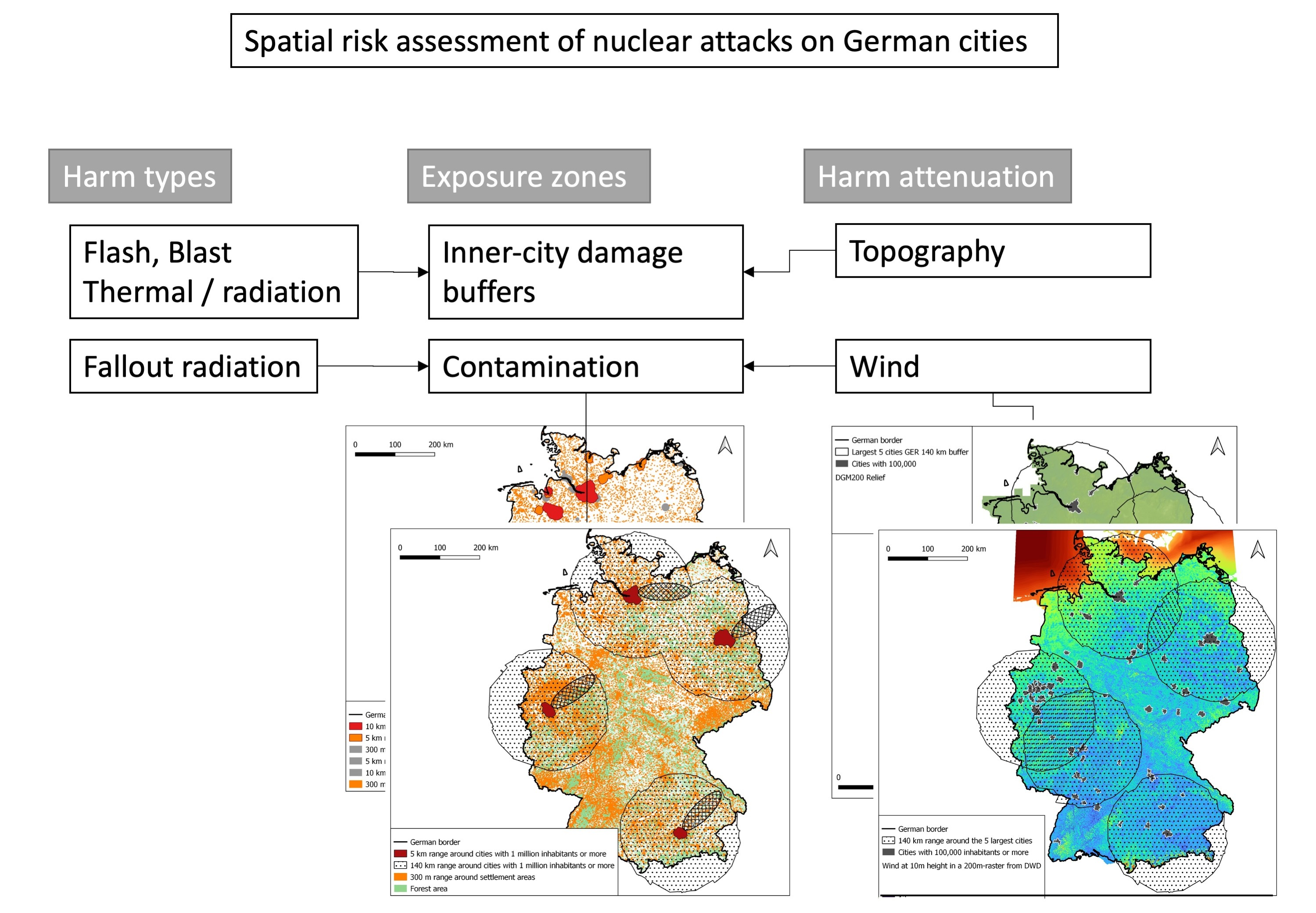
3. Results
The results consist of maps that depict hypothetical exposure to nuclear attacks. The results only show exposed areas and do not calculate casualties or differentiate certain population groups. This is because the study’s main purpose is to inform about the spatial extent of a nuclear attack and not to provide any details on casualties that could be misused as a form of information to identify an optimal distribution of attacks. The first map shows an attack scenario for Central Europe. Major cities with more than 1 million inhabitants are selected, and the buffer circles of impact from cruise missiles are shown. The results show that large areas of Central Europe would be devastated by the combined effects of the fireballs, blast waves, thermal and other radiation, and fallout (
Figure 1).
The results also show that some areas would not be affected. Several remarks of caution have to be made here. First of all, the selection of cities in all countries in Central Europe and only those with 1 million inhabitants or more is arbitrary. The selection of weapon sizes in the range of cruise missiles is also arbitrary, and circular buffer ranges do not depict real contours of fallout, which would depend on wind direction and speed. We could also have selected larger weapons such as ICBMs, where one missile with several warheads could lead to much larger areas being affected by fallout. However, the selection of the largest cities is intended to show the most likely targets when population density is targeted. Furthermore, the circular representation of fallout is misleading for a real case because not all wind directions would occur. However, for the target group of civil protection planners and the population at risk, it is important to know where around a city an area could be affected, and this is dependent on the wind direction, which can change in Europe due to the meandering highs and troughs over Europe. Even wind from the east or north can occur. It is also easily imaginable that larger weapon types or a higher number of missiles would easily cover the whole area in Europe, regarding fallout exposure. The map here is to show how Germany is embedded in Europe, with many neighboring countries which also could be targets for attackers from many countries that possess nuclear weapons. A relatively high population density characterizes Germany, but just as well this is the case for the United Kingdom or adjacent Belgium and the Netherlands, the south of France, the center of Italy, and many more. Furthermore, if only one country is selected as a target, neighboring countries in Europe are quickly affected as well.
Germany has four cities with a population of 1 million inhabitants or more. The map shows that already with those four targets and the usage of 150 kt nuclear warheads, almost half of the territory of Germany would be affected by fallout radiation risk (
Figure 2).
The greatest risk is to the urban centers in a range of 5 km around the target area. While earlier nuclear weapons, due to accuracy problems, were mainly focused on large urban centers, street crossings, or other visible sites in a city, modern missiles can be directed to different parts of a city. Because the exact location will be unknown to the civilian population, the buffer selected here is adjusted to the urban perimeters. This provides information on areas within a 5 km buffer zone to avoid in case of planning for evacuation sites, for example. In a real attack, not all parts of the city would be covered, but it is unknown where the bomb would land. What can also be seen on the map is that a great ratio of other large German cities with populations over 100,000 people are already within the range of the nuclear fallout of those four major city targets. In the remaining area, few cities of large size remain that would not be exposed and could also be used for evacuation. Rural areas, especially those without settlement areas or industrial areas such as agriculture or forest areas, are useful for planning evacuation areas. However, because nuclear fallout also produces short-lived nuclides of, e.g., iodine, not just 137Cs, taking shelter inside at first may be a better option than starting to evacuate immediately.
A real case scenario of fallout exposure risk is seen on the next map (
Figure 3). For the estimated ellipsoid fallout contour lines with assumed wind speeds of about 25 km/h, the area is much smaller than depicted by the buffer circles of 140 km distance. The contour lines for these wind speeds are obtained from NUKEMAP also and represent just a rough idea of the shape of such windsocks, as they sometimes are also named. This is important to convey to planners for an evacuation; not all areas around one site are hit by one attack due to the situational wind directions. However, wind speeds and directions vary, and therefore, the buffer circles must also be used for planning.
The wind direction, which in Germany is predominantly from the southwest, makes it likely that areas in the northeast would be affected by fallout radiation risk. Again, it must be warned that wind directions in Germany change, and therefore, the buffer circles must be used to identify all areas potentially exposed. The map also shows additional settlement areas and industrial areas with a 300 m buffer, as in the case of a war unfolding over longer time periods, other settlement areas could also become targets of smaller bomber-based missiles. Again, it is unrealistic that all settlement areas would be bombarded with such types of missiles. The map intends to identify areas that could potentially be exposed and considered for demands of shelter within urban areas and rural areas outside of the vicinity of settlements. The map also shows that overall, many smaller-size cities of Germany would be affected by the immediate impacts on the four major cities and the fallout radiation risk. To compare the selection of four cities in Germany with another scenario, another map is shown. The map shows large cities in Germany with 500,000 or more inhabitants (
Figure 4).
With the same type of nuclear weapon, now almost all of Germany would be covered by fallout radiation risk. Only a small stretch from the center to the southeast and some pockets in the very northeast and center-east remain. Two larger cities can be seen in this area in the center that could be used for evacuation planning. Large cities need separate planning because urban areas are highly at risk from the blast, fire, and radiation, which would suggest identifying underground shelters. However, for the areas up to 140 km around those cities, a warning time of 15 min and maybe more would enable evacuation activity. Radiation fallout not only needs time to rain down, but it also propagates with distance. Therefore, areas at the perimeter are likely to have more time to evacuate or seek shelter. Planners of shelter sites in civil protection services could use such information to identify the areas at the outer perimeters of such buffers to designate evacuation sites. More information about the time to seek shelter and dynamic developments of fallout radiation would be very helpful also for planning concerning larger weapon sizes. Because the area of Germany is restricted, the outer rims of such buffer circles could be selected.
Fallout radiation risk is difficult to predict, and buffer circles of 100 km or more in dimension may provide an impression of the futility of planning. Fallout radiation risk cannot be neglected, but the worst impact comes from the direct target area. The next map shows an aggregation of such immediate impact zones without fallout radiation buffers (
Figure 5).
To avoid disclosing sensitive information, different types of likely targets have been merged. Large cities in Germany and other settlement areas, but also chemical parks, nuclear power plants, and other industrial sites, as well as harbors and other infrastructure, could be targets. The map shows that target areas are extensive, even without fallout radiation risk. At the same time, for initial waves of attacks, it can be assumed that smaller cities would not be prime targets, unless other targets of strategic military interest exist near those cities. Civil protection planning must focus on this range of risks and prepare plans for directly affected urban areas.
After identifying hypothetical areas susceptible to attack, it is also important to identify less exposed areas that can be used for evacuation site planning. The next map shows forest areas exempt from population density which could be used for evacuation site planning. Swamp areas and other less suitable areas have been excluded (
Figure 6).
Additional factors can play a role in designating areas less affected by a nuclear bombing. For example, one factor that decreases the effectiveness of bombing, both conventional and nuclear, is topography. The next map shows the differences between the areas around the five most populated cities in Germany (
Figure 7).
Again, the selection is arbitrary but can help to highlight differences in exposure between cities. The two cities in the north lie in low surface topography. This flatland promotes easier propagation of the damaging effects of nuclear weapons. This is also true for conventional bombings. For example, in World War II, Hamburg was hit by a firestorm triggered by bombing. The topography supported such fire development. Cities in the south of Germany, close to the Alpine region, and other cities with mountainous or hilly terrain have more valleys that can be useful as ditches to dampen certain effects of blast waves and thermal and radiation propagation. They will not be excluded from fallout radiation, but their exposure will also vary depending on the wind direction.
Another factor to consider is wind speed and direction. Most cities in Germany see wind coming from all directions but with a distinct profile in which winds mainly come from the southwest. Wind speeds are also important for estimating travel times of radiation clouds and other effects of aerial propagation. A map of average wind speeds collected from the years 1981–2000 by the German weather service shows that at 10 m of height above ground, wind speeds vary over the territory of Germany (
Figure 8).
The highest wind speeds occur over the sea and along the coastline in the north and in the alpine region in the south. The northwest and other pockets in Germany also see relatively higher wind speeds. Wind speeds above ground are also very much influenced by forests. This can also be seen in comparison to the next map; there are areas, especially in the center and east, where forests would diminish the wind speeds of vapor clouds and other types of cloud propagation. Some parts in the south are surrounded by basins and mountainous areas where lower wind speeds could slow down cloud propagation. However, they also produce more stagnant conditions, permitting longer times for radioactive clouds and rain to affect the soils.
The next map shows wind speeds at 80 m above ground (
Figure 9). Pockets of higher wind speeds in the center and south of Germany become more visible. Forests do not influence the distribution anymore, nor do other buildings or factors of surface roughness. This map can be helpful in identifying radioactive cloud propagation at higher elevations above ground.
For some of the affected cities, such maps can also be useful to differentiate better the evacuation sectors in the different wind rose-derived segments of a buffer circle. For example, in the north there are higher wind speeds along the coast and to the west than in the southeast. This can indicate areas where radioactive fallout clouds would be cleared more quickly.
4. Discussion
Humans are often divided between taking risks seriously or not. In addition, geographers wonder what to contribute to the nuclear topic and whether it is a moral obligation to inform and educate people about it [
47]. Risks of harm range from minor to major, and nuclear war is at an extreme end. It is thus of no surprise that people have been even more divided since the advent of atomic bombs over whether it makes sense to prepare the population or not [
48]. There are known psychological factors of humans reacting to risks they cannot see, touch, or control or that are not immediately relevant to themselves [
49]. An additional factor might be unknown consequences and complexity that can overwhelm common understanding. Therefore, this paper has analyzed whether a nuclear war on a battlefield in Central Europe would immediately lead to the exposure of all humans in Germany. Harm is differentiated into different types of hazards; in a nuclear explosion, the harm and damage involve flash blindness and retina burns, impacts on buildings that can collapse, thermal burns to skin, and immediate radiation effects [
25]. While these effects are the most extreme, their aerial extent is limited and, due to the logic of attack, likely to be confined to urban centers, probably of the largest cities. Areas of 10 km in diameter and more are immediately affected, and over the course of two days, those effects, including radiation, decrease again [
25]. This is already unknown to most of the public, who have not perceived the risks of a nuclear attack in recent decades, at least since the end of the Cold War. However, the Ukraine war has renewed this nuclear threat on military targets and cities as well as on expired nuclear power plant facilities. It remains a hypothetical scenario at the moment whether any political leader, now or in the coming decades, would opt for the nuclear option in a conflict. An erratic authoritarian leader could do so in many of those countries that have nuclear weapons. Nuclear risk is not only due to conventional warfare but could also be triggered by terrorists, malfunctions, or just accidentally [
15,
36]. It is important to consider directed as well as undirected attacks, and immediate impact areas as well as fallout risks. This is difficult to map and remains mostly hypothetical due to the possibilities of the type and size of the weapon, missile and launching accuracy, fission rate, wind speed and direction, and many more factors. The results show that with weapons currently in the arsenal of the two main superpowers, the United States and Russia, any area in Germany and Europe (and also worldwide by bombers or submarines) can be reached. Assuming that only the largest cities in Germany would be selected for an initial attack, the effects of fallout are much larger in spatial extent than the other forms of harm of a nuclear weapon. Fallout in higher atmospheres will also disperse over the major wind zones over the whole planet [
13]. However, options for evading this radiation exposure are given. There is time for warning and seeking shelter. While very large areas up to over 100 km in length and more than 10 km in width in a typical windsock contour would be contaminated, there would be enough other sectors in a buffer around the attacks where people could survive. Overall, this study identifies the spatial exposure patterns of nuclear warfare and areas to be considered in advance for civil protection to prepare as possible evacuation destinations. The results show that rural areas would be preferred, as would those outside of the range of the largest cities. In a densely populated country such as Germany, very few areas remain that would not be affected in the unfortunate circumstances of an attack on only three to five German cities. This means that fewer than 10 targets can already be devastating; however, again, it must be noted that the windsocks will likely not affect the whole country.
4.1. New Geographies of Risk and Safe Places Emerging
As a result of such risk assessments, new spatial risk geographies emerge. Geographically, rural areas are better for the immediate survival of a nuclear attack. Of course, this places an additional burden on rural areas in the periphery, which often are characterized by depopulation and lower density of infrastructure supply and sometimes also characterized by lower economic conditions. Smaller cities also fall into preferable evacuation sites. They might not be the main or secondary targets in a missile attack scenario. Only in the long term, upon the invasion of a foreign army, would small cities would also not be preferable. Topography can provide protection in hilly terrain, and buildings can provide important shelter against many types of harm from a nuclear attack. Elevation, distance to the sea, and terrain roughness can also help identify areas of preferable wind conditions. Therefore, a civil protection strategy must include preparedness measures in urban areas, even in the centers, but also in more rural areas. The ambition of this study is not to draw an aggregated map of immediate use for civil protection planning or to prepare the population. The ambition is to identify options for spatial assessments and risk factors that can easily be accessed and used by other countries in their studies already. For Germany, at least, public information on spatial nuclear risk exposure is missing. The study, therefore, calls for using existing information on geographic and demographic factors as well as the types of weaponry and risks of harm. As this study shows, even worst-case scenarios can be broken down into different forms of harm and spatial impact areas, which can better inform specific measures. It shows many ways of survival, even when safe areas cannot be designated due to unknown numbers of warheads and destinations being selected. However, this paper can also prevent passiveness and the main mistake of all: not to prepare for a disaster risk that is already known.
Another geopolitical geography that emerges with such scenarios of areas characterized as being susceptible targets is determined by the overall political stance of a country in opposition to an attacker. Therefore, protection efforts must be informed not only about spatial extent of vulnerability but also consider many more societal and political factors. Geographers point out that understanding ‘riskscapes’ must include spatial and temporal aspects but also aspects of power, practices, plurality, and subjectiveness of social groups [
50,
51]. Riskscapes are manifold, but hazardous facilities are one example, and urban areas also have specific riskscapes [
52]. The case presented here is an example of a global risk that includes many aspects of technological, societal, environmental, and geopolitical risks [
51]. The study here is limited to spatial exposure aspects. Still, it can serve as a starting point to analyze other aspects of risk such as temporality or behavioral implications and practices in future studies.
4.2. Civil Protection Preparedness
The study also can provide guidance to civil protection planning in terms of where to locate important centers of civil protection information, command and control, and shelter. It should be considered whether the main information centers and public administration sites and governmental replacement sites and other facilities should not be located outside of the immediate range of the largest cities in Germany. It is important to also consider placing important archives and shelter for the population outside of the likely first targets.
It is also important to learn from past events. So far, most of the literature is based on the two nuclear bombs dropped on Hiroshima and Nagasaki as well as on nuclear bombing tests. However, nuclear power plant accidents can also provide important information. For example, the nuclear accident at the Fukushima power plant in 2011 has shown how important it is to conduct evacuation not only by looking at buffer circles. Wind direction and speed also have enormous importance. Unfortunately, in the case of Fukushima, some people were evacuated from sites closer to the accident that were not exposed to the final radiation to areas more distant that then became affected by fallout [
53]. False dislocation or evacuation into exposed areas is difficult to predict or avoid in a disaster situation, given the lack of information that is immediately available. However, now in times of peace, modeling and information systems should be especially preparing for wind directions and their changes. For example, crossing likely areas of fallout in main evacuation directions should be avoided.
Providing more accurate information about the timing factors is also very important to consider. Estimations of the time for fallout to contact soil differ, but some studies mention a time of 15 to 30 min [
37,
40]. This can provide enough time for evacuation, even for people not having a car but having access to other means of transportation or just walking. In a car traveling at 160 km/h, 40 km can be driven in 15 min. However, in emergency situations, driving at such high speed is rather unrealistic, and traffic jams have to be considered. However, slow cars and other means of transportation such as public buses and trains might cover more than 10 km. Obtaining precise information on cell phones over the exact ground zero and wind direction combined with simple modeling could easily help residents know in which direction not to evacuate. This all has to be conducted in a holistic way, and the ‘last mile approach’ considers population needs and perspectives as much as those of the incident command chains. Residents, commuters, and tourists all need to know that as long as they are outside of the immediate damage circle at ground zero, the fallout can best be avoided by seeking shelter in buildings, preferably underground areas surrounded by concrete and 1 m of soil. Such information needs to be ready to be distributed.
4.3. Future Options to Improve Exposure Assessments by Vulnerability Studies
Vulnerability is addressed early on in terms of structural damage vulnerability and related equipment to reduce the vulnerability to shocks by elasticity and more [
25]. The vulnerability of a country such as the United States overall is regarded in relation to target attractiveness [
54]. The vulnerability of missile launch facilities is addressed [
34], as well as water utilities and transportation [
55]. This perspective of “vital targets” of an enemy’s industrial system has influenced military but also strategic governance in its system-vulnerability thinking in the 20th century [
6]. This protection of vital systems also influenced the development of ‘critical infrastructure protection’ in the late 1990s [
6]. It also draws connections to “vulnerability mapping” of strategic targets, which include cities especially; “Vulnerability mapping enabled planners to understand cities and the systems that composed them as sites of potential future disaster and as complex landscapes of response [
6].”. While this would be the first line of impact, additional secondary impacts also were considered. For example, vulnerability is also addressed regarding crops and seasons and fallout radiation [
30]. Coming from natural hazards research, it is quite surprising to see also studies on societal vulnerability, in terms of how social structure and social institutions could be vulnerable to attack, as early as the 1960s [
56], while in natural hazards research this is generally considered a major paradigm shift happening after the 1970s, or even the 1990s [
57]. Social vulnerability aspects of human behavior, knowledge, organizational structure, and more in reaction to “massive attacks” are addressed, from the warning to recovery phases [
56]. It is interesting for vulnerability indicator studies that population sizes, but also age, gender, education, and more factors, are discussed. An observable system of a society is differentiated into the ecological, cultural, individual, and social systems [
56], long before the Brundtland report on sustainability [
58] put the triangle of ecology, economy, and society into focus and gained recognition in natural hazard risk studies [
59]. It is especially surprising to read in this source that ideas of interdependent systems, feedback loops, emergence, dynamic paths, resilience, social-ecological systems, and social vulnerability indices, aggregated from indicators, all had already been developed [
56]. This provides many options for future studies to expand the notion of the risks of nuclear warfare beyond spatial exposure and physical or target vulnerability.
4.4. Future Options to Improve Exposure Assessments by Studies on Capacities
Civil defense development history has followed military and political-strategic development. Early on after WWII, strategy papers such as the Hopley Report were criticized regarding costs, unrealistic scope, and transferring a civilian responsibility to the military [
60]. In Germany, civil defense lost its official stance in strategy papers about interior security and received critique by suggesting an illusion of surviving an atomic war while at the same time fostering war-readiness in the population [
4]. The U.S. Congress rejected funding of large-scale public shelters due to costs and the handling capabilities of the Federal Civil Defense Administration, but also due to fears of communistic living in group shelters and state centrism in the McCarthy era [
16]. Instead, only advice on private shelters in basements or backyards was what the FCDA could offer.
Identifying and preparing shelter, including “evacuation to shelter”, taking into account transportation and access became important capacities to develop later on. Capacities were often calculated by analyzing the vulnerability maps, which show gaps and room for improvement in civil defense preparedness [
6]. Safe areas were identified in the expansive rural areas of the Soviet Union in their civil defense plan for urban evacuation [
61], reducing the vulnerability as compared to the United States to about one-tenth [
62]. For the United States, an estimated 50 million lives could be saved by shelter options [
27]. Safe areas in the literature about a nuclear attack or war most often refer to shelter, be it public, private, or evacuation sites. However, studies on safe areas or safe havens are rather rare in comparison to studies on the threat itself. One area of improvement is, therefore, on the strategic or governance side of capacity development options.
Another area of future development is deriving better capacity options through better planning and assessments. Most risk and exposure studies are rather static and focus on spatial extent only but fail to consider time. An important improvement would be the assessment of time to evacuate or to access safe areas, as is conducted for wildfire and other health-related risks, using routing or isochrone assessments, for example [
63]. It is possible to derive nuclear explosion effects and their durations that can help to guide warning and evacuation times. Exposure’s spatial and temporal effects are multifold; the following information in the next paragraph is derived from the seminal report from 1957 [
25]: Peak overpressure results in maximum wind velocities of up to 3344 km per hour, lasting several seconds. Arrival times on the ground of a blast wave for a 1-kiloton burst reach a distance of 1000 m in about 2 s and 2000 m in about 4.5 s. Twenty minutes after the detonation of the nuclear bomb in Hiroshima, a mass fire developed. Fallout with at least total doses of 10 rads/hour of radiation after one hour reaches 48 km at a 1 Mt fission yield, by 24 km/h effective wind speed, and then 137 km after 6 h, and 322 km after 18 h. Ionization effects affecting radio and radar signals are effective until 2–3 h after the explosion. An electromagnetic pulse is produced within milliseconds. Retinal burns occur up at to 145 km in the daytime and 241 km in the nighttime when the bomb detonates at 15.2 km of height. Warning times from submarine missile attacks on Australia are estimated at 15–30 min [
37].
5. Conclusions
There is currently a surge of interest in the war in Ukraine in research and disaster risk reduction policy. Understanding systemic risks and aligning agendas of climate change adaptation, disaster risk reduction, urban settlement development, and humanitarian issues is much demanded to generate a more holistic understanding of disaster risk. Such a holistic understanding integrates different types of hazards and risk landscapes. While it is rather uncommon for researchers within natural hazard domains, it is more common to consider an all-hazard approach in civil protection or defense studies. After the Cold War, a new age of hybrid threats and various natural and man-made hazards have shaped civil protection strategies. A new focus on systemic risks or interdependencies of targets has also come into focus, for example, critical infrastructure or cyber threats. Civil protection sometimes uses a combination of selected scenarios to consider a variety of both threats and impacts. For example, a natural hazard is one scenario that depicts a rather random occurrence. A scenario of an epidemic is effective mainly on humans directly and has a large component of snowball spreading. A third scenario is a deliberate attack. The nature and type of threat are not so important for the last scenario, be it a lone saboteur, a mob, or warfare. What is more important is that the third scenario is led strategically by intelligent human beings. This makes it about the most dangerous of all three scenario types. Furthermore, from all types of deliberate attacks, war is probably the maximum worst-case threat to humans. It is in a similar category to a comet or space debris crashing into the earth.
Nuclear warfare is the most extreme threat scenario in this line. After the end of the Cold War, recent events have shown that it is a renewed, ongoing threat. Not only the current aggression of Russia against its neighbor, Ukraine, has renewed attention to the possibility of nuclear war. An erratic and non-rational elected president could just as well as other authoritarian leaders of countries with nuclear weapons trigger a nuclear war, intentionally or unintentionally. The purpose of the study is not to instigate fears or argue for the increasing likelihood of nuclear war to happen. In the line of thinking of civil protection, the sole purpose is to consider ‘what if scenarios’ and focus on possible impacts on populations and societies. The paper, therefore, investigates possible exposure zones to nuclear warfare. Exemplified in the case of Germany, it is analyzed how different types of nuclear weapons are directed at likely targets. The objective is to identify whether unexposed areas exist even within a country such as Germany, which for decades has been in the center between nuclear powers as a potential battlefield. While commonly it is often assumed that the ‘whole world’ would be exposed to a nuclear attack, it is important to differentiate between direct and indirect exposure and also to possibly identify areas with less likelihood of exposure in a densely populated country such as Germany. While such an article may be disturbing to many that are outside of civil protection, it is regarded as important to be transparent about real, existing dangers rather than to hide obvious facts.
The results reveal that half of the territory of Germany is already exposed to radiation risk when only four or five cities are attacked. However, chances for survival also exist even in these areas that are not affected by the fallout when it is carried only in one main wind direction. Safe areas are also shown in rural or small city environments. In conclusion, the threats and risks of various sources of harm from nuclear explosions should not be neglected or concealed. However, it is possible to designate areas that maybe are not entirely safe but are safer from harm than others. Some will struggle with the unknown, while others relax when understanding more about risks, exposures, and options to evade them. While the big wheel of geopolitics keeps on turning, it is likely that the Earth still spins on its axis, even in a nuclear conflict, when supported by some remnants of human logic.


