Abstract
The Oum Er-Rbia estuary is located on the Atlantic littoral of Morocco. It undergoes severe clogging due to the sand deposition in its outlet. The current study examined the indicators of the morphodynamic evolution in the littoral system including the Oum Er-Rbia estuary and the neighboring beaches over 1970–2017. The methodology adopted was based on the analysis and the interpretation of aerial photographs and Google Earth images under a GIS environment and field work. The morphodynamic evolution was discussed by taking into account the evolution of hydraulic facilities installed in the watershed area, especially the construction of dams, as well as the dredging works in the Oum Er-Rbia estuary. The results highlight the morphologic evolution estimated in terms of surface units observed in the estuary and the neighboring beaches. The evolution of the littoral system was mainly influenced by the closest dam location and by the dredging works, in addition to the regulation of the river flow by the installation of hydraulic facilities upstream.
1. Introduction
The design of any sustainable development strategy should necessarily incorporate the concepts of environmental preservation and the rational management of natural resources. However, this expectation is not always easy to achieve because it is often hampered by compelling socio-economic requirements.
According to many researches aiming at the digital modelization of estuaries and the prediction of their behavior, it has been demonstrated that their functioning is complex in most estuaries of the world due to the action of many factors controlling the equilibrium in these environmental systems [1,2,3,4,5]. Indeed, the factors controlling the morphodynamics of estuaries and deltas are variable, including natural factors such as sea level change, swell and tide actions, storm event, fluvial hydrology, etc., and anthropogenic factors such as hydraulic facilities, engineering works of protection and rehabilitation, dredging, etc. [6,7,8,9,10].
The bathymetry and the morphology of an intertidal plain and transversal section of a shallow bottom estuary cause a tide asymmetry that affects the flow duration, compared to the ebb time, and the celerity of the tide current [1,2,10,11,12]. In coastal environments, the waves generate coastal currents that interact with incident waves and lead to the sediment transportation and the process is favored when the angle between the waves and the coastal line is significant [13,14,15,16]. As a response to coastal hydrodynamics, the alternation of sedimentation and erosion processes in the estuary can generate net sedimentary balances through a tide cycle [17,18].
The installation of hydraulic reservoirs in upstream areas affects the hydrodynamic equilibrium and sedimentary balances downstream, due to the flood water regulation and the decrease of the solid sediments supply [19,20,21,22,23,24,25]. Blott) [26] concluded that the morphodynamic evolution of Mersey estuary in England through a period of 150 years was mainly controlled by engineering and rehabilitation works, such as the construction of training walls and dredging. Besides, the importance of other factors, notably sea level change, tide amplitude, wave current, and supply of fresh water was relatively reduced [26].
The perturbation of estuarine hydrodynamics is permanently regulated by morphologic transformations through sedimentation and erosion processes mobilized to re-establish the hydrodynamic equilibrium [21,22,27]. The morphodynamic change concerns the estuary outlet, the main channel, and the intertidal plains [19,20,28]. In addition, the morphodynamic change in the estuary affects the morphology of neighboring littoral areas and, consequently, causes the shoreline fluctuation [3,29,30,31]. Numerous works have analyzed the morphologic evolution of coastal systems through multi-temporal photographs [30,32,33,34,35,36,37,38,39,40].
This study is an attempt to provide elements to aid in understanding the Oum Er-Rbia coastal system’s behavior by analyzing the estuarine morphodynamic evolution and comparing it with the evolution of the hydraulic facilities installed in the catchment area, as well as the shoreline changes observed in the neighboring marine beaches.
2. Materials and Methods
2.1. Study Area
The study area is situated in the northern part of Morocco, where a Mediterranean climate is dominant and is characterized by a significant contrast between a brief pluvial period and an elongated dry period [41,42,43,44,45,46,47]. Indeed, drought periods affected the hydrodynamics of the surface waters [48] and a dam construction program has been running since the 1960s in Morocco to combat the effects of drought by the management of surface water mobilization in all watersheds throughout the country, especially in the Oum Er-Rbia catchment area. The decrease in rainfall observed during the 1980s was accompanied by a sharp decrease in the annual availability of surface water at the Oum Er-Rbia catchment area, with a rate of 30% to 40%, and an interannual average volume dropping from 3930 Mm3 between 1941 and 1981 to 2345 Mm3 between 1981 and 2009 [49]. The hydrological infrastructures installed on the basin make it possible to mobilize up to 93% of available resources [50,51,52,53]. The principal dams constructed downstream of Oum Er-Rbia are the Massira, put into service in 1980 with a capacity of 2760 Mm3, in addition to compensation dams, notably: Imfout in 1944 with 18.2 Mm3, Daourat in 1950 with 9.5 Mm3, Sidi Said Maachou in 1929 with 5.5 Mm3 and Sidi Daoui in 1985 with 5 Mm3. The location of these facilities is shown in Figure 1c.
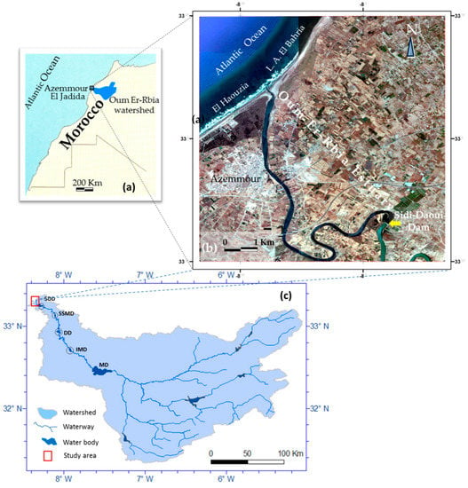
Figure 1.
(a) Location map of the Oum Er-Rbia watershed; (b) investigation area showing the Oum Er-Rbia estuary and the neighboring beaches as well as the Sidi Daoui dam location, and (c) the Oum Er-Rbia watershed, drainage network, and water bodies including the Massira dam (MD) and compensation dams situated downstream: Sidi Daoui (SDD), Sidi Said Maachou (SSMD), Daourat (DD), and Imfout (IMD).
The studied coastal system includes the bay beaches of El Haouzia and Lalla Aicha El Bahria as well as the Oum Er-Rbia estuary. It is located near the Azemmour city, between the longitudes 8.16° W and 8.22° W and the latitudes 33.15° N and 33.21° N (Figure 1). It constitutes the downstream zone of the Oum Er-Rbia watershed area that is 34,000 km2. The main watercourse is 550 km long and constitutes the longer stream system and the most regular in Morocco. The channel in the study area represents less than 3% of the main watercourse, but its situation downstream makes its important as a zone sensible to hydrodynamic changes in both upstream and littoral areas. The hydraulic infrastructure is composed of fifteen dam reservoirs, installed on the Oum Er-Rbia main stream and its tributaries [51,54,55], where the closest construction is the Sidi Daoui dam at 15 km upstream.
Figure 2 shows the location of Sidi Daoui dam installed 15 km upstream of the estuary outlet.
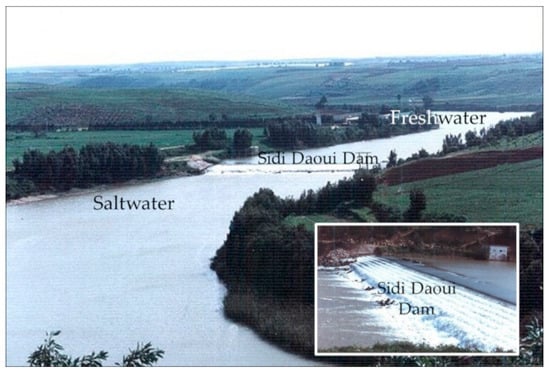
Figure 2.
Overview of the Sidi Daoui dam in the Oum Er-Rbia estuary showing flow over the wall of the dam.
The geomorphology in the study area is dominated by the eolian dune ridges edified by the NW and ENE winds characterizing the Moroccan littoral zone [56]. Pebble deposits are well developed on both El Haouzia and Lalla Aicha El Bahria beaches and are of a sedimentary and eruptive nature. Their sources are the outcrops crossed by the Oum Er-Rbia river.
The sedimentary bodies of the estuary and neighboring beaches are part of recent formations of Quaternary age. Upstream, the channel of the estuary is meandering and is approximately 200 m wide. The shores are usually steep and tree-covered cliffs. Downstream, the channel is straighter and the banks are plain, bare or planted with shrubs.
The estuarine hydrodynamics are mainly controlled by the river flow and tidal currents. The highest monthly mean flow of the Oum Er-Rbia River is generally observed in March and the lowest in August with 40 m3/s. According to the “Conseil Supérieur de l’Eau” (CSE), the absolute minimum was recorded at the Imfout check station in August 1984 and was about 14 m3/s [57]. In the Oum Er-Rbia estuary, most of the water flow corresponds to the release of water from dams situated upstream [58]. The tide is semi-diurnal on the Atlantic Moroccan side and its amplitude at the estuary alternates between approximately 1.5 m and 4 m, according to the Casablanca Port maritime services. The swell dynamics have a WNW to NW dominant direction during 78% of the time and its effect is generally important along the Moroccan Atlantic coast in autumn and winter [59]. The most efficient swells have a period T ≥ 11 s which represents 59% of the time [59,60].
2.2. Data Used
This study was based on the analysis of two types of data: (1) the hydrologic data provided by collected from the Moroccan Direction of Hydraulics (DH), including historical data for the period between 1926 and 2017. The information concerns the monthly mean flow of the Oum Er-Rbia River collected from the Sidi Said Maachou station for the periods of 1926–1928 and 1930–1939, the Imfout observation station that provided the data for the period of 1941–1970, and the Massira station for the period of 1979–2017, in addition to data on the capacity of dam reservoirs installed in the river catchment area [50,51,54]. The dataset was completed with information provided by the “Office National de l’Eau Potable” (ONEP) [52,55], the CSE [57,61], as well as data from studies by Loup [41]. Hydrologic data concern equally information on the swell dynamics and its impact on the Haouzia bay from the works of Chaibi [36,59,60]. (2) Cartographic data were extracted from two aerial photographs covering the estuary area for each one of dates 1970 and 1988. The photographs were produced at 1/40000 scale and with a 10.5 km × 11.5 km scene size. Two other photographs corresponding to 1982 were used. They are at the 1/7500 scale and a 1.75 km × 1.75 km scene size, but they cover the estuary outlet and a part of El Haouzia beach only. The aerial photographs are available at the “Agence Nationale de la Conservation Foncière, du Cadastre et de la Cartographie” (ANCFCC, Rabat, Morocco). Information was equally taken out from Google Earth imagery, through images provided by DigitalGlobe, CNES/Airbus, and Landsat/Copernicus. Seven images were used for the years of 2004, 2009, 2011, 2012, 2014, 2016, and 2017. The topographic map of Azemmour at the 1/50000 scale was used as a reference for rectifying and geo-referencing the used images.
2.3. Methods
The methodology adopted in this study is summarized in the flowchart of Figure 3. The statistical processing of hydrological data was performed using Excel software. It was used to estimate the water flow downstream of the Oum Er-Rbia River and to compare it with the evolution of the cumulative capacity managed, the rate of evolution relative to the total cumulative capacity, and the difference value expressed in percentage of the entire capacity. The monthly volume of water expected to reach the estuary was estimated by subtracting the allocations reserved for irrigation of the Doukkala perimeter, and for industrial and urban uses in the Casablanca-Safi coastal zone, from the total volume of available water released by the Massira dam. The calculation of the added value in % of capacity was based on the volume of managed reservoirs in the Oum Er-Rbia catchment area, relative to each period expressed in % of a total capacity of 5301.7 Mm3. These variables reflect the impact of the construction of hydraulic facilities in the catchment area on the hydrodynamic evolution downstream of the Oum Er-Rbia River.
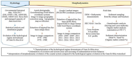
Figure 3.
Flowchart showing the methodology adopted to analyze the morphodynamic evolution of the coastal system of Oum Er-Rbia.
The mapping of the morphologic evolution of the coastal system including the Oum Er-Rbia estuary and its neighboring beaches was based on the interpretation of the aerial photographs and Google Earth images. The preprocessing of aerial images was performed under the ArcGis software environment and consisted of geo-referencing and ortho-rectification by applying an image to image method that uses common fix points. The Lambert conformal conic projection “Nord-Maroc” was used to display the images. The target line features were extracted directly from Google Earth images through the Google Earth server and exported under Keyhole Markup language Zipped (KMZ) format. The extracted lines were then displayed in ArcGis by transforming them to shape files. A coordinate system transformation was done from WGS84 to national coordinate system: Lambert “Nord-Maroc”. Fletcher et al. [62] consider that the low water position is useful to reveal changes related to alongshore rather than cross-shore profile adjustment. In addition, low water position allows for the following of the geomorphic evolution of sand bars within the estuary. Indeed, the limits of the river banks and the boundaries of the sand bars along the channel were targeted in the estuary. For the shoreline detection, many researchers consider that what is often referred to as the upper limit of the tidal level [30,31,33,34]. This is a wet and dark area that can be followed and mapped less difficultly. The selected images met best the objective, when the date and time of the acquisition coincided with the low-tide phase and the upper limit of the tide was still detectable. The target limits were then identified by the contrast of gray scale for aerial photographs [33,34,35]. The same extraction method, based on color contrast, was used for Google Earth images [30,31,36,37].
The morphological state of 1988 was compared to that of 1970, while each image of the Google Earth series was compared to the previous image, starting from 2004 as a reference situation. The superposition of lines corresponding to two successive periods, using GIS techniques in ArcGis, made it possible to draw zones of accretion and erosion and calculate surface budgets of erosion/accretion reflecting the morphodynamic evolution of the coastal system.
The morphological analysis was completed by the processing of the digital terrain model DEM (Source: United States Geological Survey USGS) using the U.S. Hydrologic Engineering Center - River Analysis System (HEC-RAS) application and ArcGis software. The treatment provided the opportunity to generate a 3D perspective view of the watercourse between the Sidi Daoui dam and the estuary outlet.
The data collected in the field include, on the one hand, bathymetric measurements taken in March and July 1997 along the central line of the watercourse and useful for following the evolution of its topography, and, on the other hand, the sampling of sediments for particle size and organic matter content analyses. The granulometric characterization of the conserved sediments was based on the “Association française de normalisation” (AFNOR) sieving method to determine the sand and mud fractions. Samples from the stations S4, S7, and S9 were selected and processed by the laser-based microgranulometric method, using a Mastersizer 2000 for more precision. The same samples were analyzed to estimate the organic matter content by using the calcination method at 450 °C.
3. Results
3.1. Hydrologic Evolution of the Oum Er-Rbia River
The evolution of the hydrological regime, downstream of the Oum Er-Rbia catchment area, is expressed in terms of monthly water flow volumes recorded at the Sidi Said Maachou, Imfout, and Al Massira dams (Figure 4). These records cover a period of 92 years through which the evolution reflects two distinct periods separated by the construction of the Massira dam in 1979 that contributes more than 75% to water mobilization in the Oum Er-Rbia watershed (Figure 4, Table 1). Indeed, from 1926 to 1970, the volumes of water reaching the Atlantic Ocean were very dispersed with monthly peaks ranging between 1000 Mm3 and 2100 Mm3. The monthly average volume calculated for this period was 271 Mm3. In the second period, from 1980, the total potential volume managed in dam reservoirs over the entire Oum Er-Rbia watershed increased to 5301.7 Mm3 and allowed the improvement of the water mobilization rate in the basin at more than 93%.
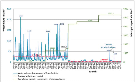
Figure 4.
Monthly evolution of the hydrological regime downstream of Oum Er-Rbia River compared to the cumulative capacity in reservoirs of managed dams.

Table 1.
Evolution of cumulative capacity managed in dam reservoirs of Oum Er-Rbia catchment area, showing the contrast between the periods before and after 1979.
Figure 4 shows that the average monthly volume for the period 1980–2017 was sharply reduced by 89% with only 29 Mm3. The maximum values recorded in 2010 and 2013, which were, respectively, 506 Mm3 in March and 351 Mm3 in April, corresponded to the controlled drain events of the Massira dam. These volumes are recuperated and regulated downstream by the compensation dams, notably Imfout, Daourat, Sidi Said Maachou, and Sidi Daoui. Exceptionally, water surpluses reached the estuary by flowing over the wall of Sidi Daoui dam (Figure 2).
Under the conditions of climate change in the 1980s, the water available in the watershed was often less than what is needed [63]. Thus, their management in terms of allocations at the beginning of each agricultural year depends on the availability in reservoirs upstream of the basin.
3.2. Drought Evolution in the Oum Er-Rbia Watershed Area
Many studies, in the available literature, on the evolution of drought in Morocco are based essentially on the calculation of the Standardized Precipitation Index (SPI) of McKee et al. (1993) [64], which is largely used and recommended [47,65,66,67,68]. This index is exploited by referring to the McKee (1995) [69] classification that defines six classes of drought according to its values, namely, extreme drought (SPI < −2), severe drought (−2 to −1), moderate drought (−1 to 0), moderately wet (0 to 1), very wet (1 to 2), and extremely wet (SPI > 2). SPI is calculated on the basis of precipitation data as shown in the Equation (1).
where Pi total rainfall of the year i, mean annual rainfall of the time series, and σ rainfall standard deviation of the time series.
The results reveal the alternation at an irregular rhythm of short wet periods with long dry periods. Severe drought periods were 1980–1985, 1990–1995, 1997–2002, and 2005–2008 without reaching the extreme conditions [47,67,68], while wet seasons were recorded in the 1970s, 1989, 1996 as the wettest year, and 2009–2010 [47]. By considering the period of 1970–2010, dry years accounted for 61.3% and wet years 38.7% [47,48].
3.3. Morphological Evolution of the Oum Er-Rbia Estuary
To assess the geomorphological processes occurring in the Oum Er-Rbia estuary, aerial photographs and Google Earth images, covering the period of 1970–2017, were selected, analyzed, and then compared. Nine shoreline positions were, thus, extracted according to the methodology adopted. Principal indicators of morpho-sedimentary evolution of the Oum Er-Rbia estuary are summarized in Table 2. The observed variations in the estuary were mainly related to the width of the river outlet, ranging from 28 m to 127 m, and its direction, relatively stable between 1970 and 1982 (5° NNE) but moving since 1988. The evolution trends are expressed in terms of clogging/unclogging deducted from the surface balance of the morphological units as a result of the deposition/erosion processes into the estuary. The corresponding results are mapped and shown in Table 2 and Figure 5.

Table 2.
Indicators of morpho-sedimentary evolution of the Oum Er-Rbia estuary.
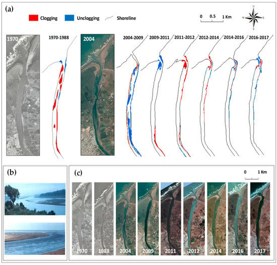
Figure 5.
(a) Assessment of the processes of clogging/unclogging in the Oum Er-Rbia estuary and its outlet; (b) field photographs showing the estuary clogging (up) and accretion on the left side of the outlet (down); (c) aerial photographs and Google Earth images of the Oum Er-Rbia estuary in the different times of spatial observation.
Figure 6 represents an instantaneous state of the Oum Er-Rbia mouth in 1982 that shows the first accretion spit on its left side and the reduction of the mouth width after the construction of the Massira dam.
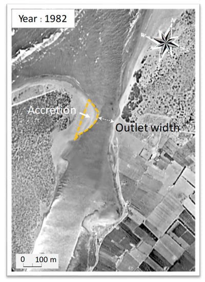
Figure 6.
The first accretion form recorded in the estuary outlet in 1982 after the construction of the Massira dam.
Figure 7 shows the location of stations and a 3D perspective view generated by the HEC-RAS application, showing the watercourse located between the Sidi Daoui dam and the outlet of the river. It is a channel with a sinuous shape which was dug into a plateau area. The follow-up of longitudinal morphological evolution was based on a succession of thirty-six cross-sections. The resulting topographic profile of the center line was then adjusted using the bathymetric data for the months of May and July in 1996 (Figure 7C). The figure shows the longitudinal topographic evolution of the watercourse bottom, with more frequent undulations downstream than upstream. It reflects that the estuary morphology has been mainly stable since 1988.
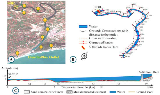
Figure 7.
(A) 3D view of the estuary between the Sidi Daoui dam and the river outlet. (B) HEC-RAS generated 3D model of the estuary studied. (C) Longitudinal section with exaggerated slope showing the topographic evolution of the river centerline between the outlet and the Sidi Daoui dam. S1 to S10: Locations of the sediment sampling, S1, S2, and S3, are taken from the littoral side as shown in (A).
The sieving-based granulometric characterization of sediments collected from the nine stations revealed the dominance of sand downstream (82–99.6% of sand), on the undulated bottom of the estuary and on the neighboring beaches, while the muddy sediments were dominant (94.1–99.6% of mud) in the upstream part of the estuary and on both sides of the Sidi Daoui dam (Figure 8). The cumulative curves resulting from the laser-based analysis of the samples S4, S7, and S9 helped to calculate the average particle sizes d50 between March and July, estimated to 253 µm for S4, 17.5 µm for S7, and 6.3 µm for S9 (Figure 9). This confirms the results obtained by the AFNOR sieving method. In addition, the sand samples showed the same mineralogical composition and the amounts of organic matter were less than 2% in sands downstream and beaches but increased up to 6.7% in muddy sediments upstream. These remarks are favorable for a marine origin of the sands collected in the estuary downstream. The estuary clogging by marine sands covered a distance of 5 km downstream where depth was between 1 m and 3 m, while the remaining part (10 km) was characterized by mud deposits and depths between 5 m and 10 m.
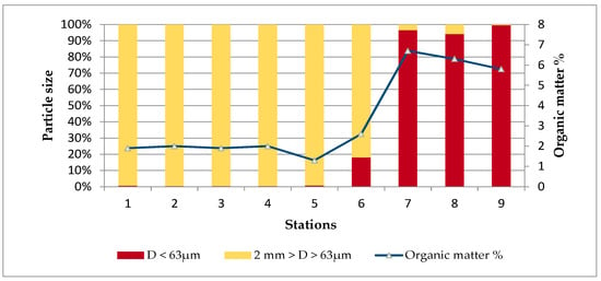
Figure 8.
Sieving-based granulometric characterization and organic matter content in the sediment samples collected from the estuary and coastal sides.
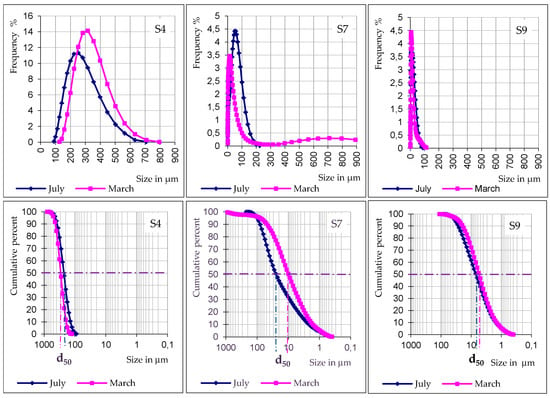
Figure 9.
Laser-based granulometric characterization of sediments taken from the stations S4, S7, and S9, showing frequency curves and cumulative curves.
3.4. Morphological Evolution of the Neighboring Beaches
The evolution in the neighboring beaches is expressed in terms of advance/retreat trends as summarized in Table 3 and Figure 10. Along the beach of El Haouzia, the evolution of shoreline position over the period of 1970–2017 indicates a global advance, resulting in an extension of the beach over an area of 57,855 m2 (Table 3). From 1970 to 1988, the evolution of the shoreline shows a clear advance of the beach of El Haouzia on a considerable surface of 94,700 m2. Locally, a retreat surface was detected near the river outlet, whereas the advance was observed into the outlet, with a north-facing and arrow-shaped sandy body, and hook-shaped sandy bodies inside the estuary (Figure 10). Since 2004, the shoreline profiles show a perceptible lateral redistribution of sands between multiple alternating zones of accretion and erosion (Figure 10). The exception was noted for the time span of 2009–2011, which showed a clear retreat trend of the Haouzia beach on a surface of 73,462 m2.

Table 3.
Morpho-sedimentary surface balance in m2 of units through the neighboring beaches of Oum Er-Rbia estuary. Positive values signify shoreline advance, while negative values indicate shoreline retreat.
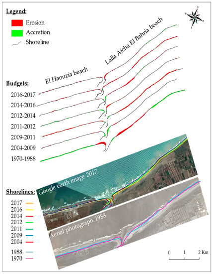
Figure 10.
Evolution of the shoreline in the beaches neighboring the Oum Er-Rbia estuary.
In the Lalla Aicha El Bahria beach, the evolution of the shoreline position showed an overall tendency to erosion between 1970 and 2017, marked by a shoreline retreat on an area of 333,285 m2 (Table 3). Short-term evolution of the shoreline revealed a first linear retreat of 57 m near the estuary outlet between 1970 and 1988 (Figure 10). Since 2004, two new erosion phases were detected, linear retreats estimated at 40 m and 31 m were revealed in the 2009–2011 and 2012–2016 periods, respectively. Theses erosion phases result in a loss of beach width estimated at approximately 2.7 m as annual mean value.
4. Discussion
The morpho-sedimentary equilibria in estuaries are established and maintained by the nature of hydrodynamic relationships between fluvial and marine dynamics and local anthropogenic activities [19,20,21,22,70,71,72,73,74]. Indeed, the morpho-sedimentary changes revealed in the Oum Er-Rbia River outlet, over time, are a direct result of local and successive hydrodynamic imbalances caused by two principal events that are the construction of Al Massira dam in 1979 and Sidi Daoui dam in 1985. These dams, and others, were installed in the watershed area to minimize the impact of prolonged periods of drought that have characterized the Moroccan climate since 1980. Indeed, the main feature of the climatic evolution is the increase in dry year frequency over time, unlike wet years which are becoming rare. Fifteen dams were constructed along the main course of the Oum Er-Rbia, which allowed for regulation of the surface waters in the Oum Er-Rbia watershed and, thus, disabled flood waters from reaching the ocean. During the drought period of 1980–1985, an annual volume of fresh water estimated at 200 Mm3 was lost at sea [75]. In this context, the Sidi Daoui dam was constructed in 1985 to stop the rise of the saline water and to save 5.5 Mm3 of fresh water needed for drinking and irrigation purposes in Azemmour city and the surrounding agricultural areas [75].
The monthly evolution of the hydrological regime downstream of the Oum Er-Rbia basin shows a drop in water input volume estimated at −89% over time, with an average monthly input of 271 Mm3 before 1970, but limited to 29 Mm3 after that date. This change can be attributed, on the one hand, to climatic changes resulting in a rainfall reduced by 30% to 40% on the watershed, and on the other hand, to the important hydrological facilities constructed in the watershed and which allowed for the mobilization and the regulation of the totality of the annual water inputs into the watershed. Also, the continental sediments reaching the ocean were also reduced by 90% [57,61,76]. Fluviatile deposits were mainly silty-clay, with total suspended solids limited to between 0.002 g/L and 0.20 g/L depending on the season [77]. Consequently, the hydrological influence of the Oum Er-Rbia River at the estuary level, in terms of fluvial energy and solid inputs, is considered irrelevant. The main morphological changes observed in the downstream part of the river, between the Sidi Daoui dam and the sea, are the result of the interaction between the marine and estuarine dynamics influenced by the dredging works downstream.
Between 1970 and 1988, the most significant morphological disturbances were observed in this period. They are mainly guided by the dam construction events resulting in a significant decrease of the impact of the upstream fluvial hydrodynamics. In 1970, the morphodynamic situation reflected a state of equilibrium among a normal fluvial hydrodynamics in humid periods, with frequent flood events able to maintain the estuary completely unclogged and a width mouth close to 125 m. After the installation of the Massira dam and under the effect of the drought of the 80s, the estuary showed the first sandy accretions at its mouth in 1982 leading to the reduction of the width of its mouth to 82 m. This proves that the equilibrium was broken due to the significant reduction of the fluvial flows reaching the estuary. The impact of the upstream Oum Er-Rbia hydrodynamics on the estuary was therefore very limited.
In 1985 and after the construction of the Sidi Daoui dam, the estuary of the Oum Er-Rbia experienced a massive clogging of its mouth reduced to 49 m in 1988 instead of 125 m in 1970. These rapid changes were guided by marine processes on both sides of the mouth. Indeed, the normal and inverse littoral drifts converging towards the mouth of the estuary favored the confluence of the sediments and their transportation into the estuary by the high tide currents [30,78]. Similar observations were also evidenced in El Haouzia bay by Chaibi [36,59,60] and in other similar environments [29,30,79,80,81,82]. The clogging of the estuary was accelerated after the construction of the Sidi Daoui dam in 1985, thus, suggesting a significant influence on the tidal dynamics, as observed in similar situations elsewhere [20,21,26]. According to many local fishermen, the clogging process was significantly activated after the building of the Sidi Daoui dam [77]. Migniot [73] and Nahon [83] explained this evolution, observed in many estuaries, as a process of equilibrium recovery by a readjustment of the energy distribution scheme in relation with the hydraulic efficiency of the estuary [75,83].
In addition, the sandy sedimentation caused the rapid clogging between 1985 and 1988 of the estuary, leading to the installation of an unhealthy and anoxic environment evoked by Idrissi et al. [84] and El Jakani [77]. The estuary clogging observed in 1988 was maintained until 2004, thus, reflecting a new state of hydrodynamic equilibrium of the estuary system [19,77].
Between 2004 and 2011, considering the continuity of prolonged drought periods and the weak effect of the upstream part of the river, the expected situation was the continuation of the estuary clogging triggered since 1982, as observed in similar situations [85]. But the observed state between 2004 and 2011 was different from the expected. The explanation for this change was attributed to human intervention by the sand dredging in two separate stages. Indeed, between 2004 and 2009, the interior of the estuary was unclogged while the mouth was always reduced. This was the result of the dredging leading to the deepening of the inner estuary of about 4 m at low tide. After 2009, the dredging at the mouth level allowed the widening of the mouth that reaches 127 m width, leading to free communication between the downstream estuary and the sea. An event characterizing this period is the breaking of the Sidi Daoui dam (Figure 11) and the appearance of accretion zones inside the estuary (Figure 10). Benzekri [75] reported that the marine hydrodynamics effects could be sensed upstream at a location as far as 20 km at least from the river mouth [75]. The construction of the Sidi Daoui dam at 15 km only constituted an amputation of a large part of the estuary’s original volume and directly caused a disturbance in the daily circulation of the high tide that can explain the dam rupture in 2011.
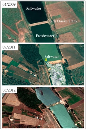
Figure 11.
Illustrations of the Sidi Daoui dam through the watercourse of Oum Er-Rbia showing its rupture in 2011 and restitution in 2012.
The coastal sides of Lalla Aicha El Bahria, mainly, and El Haouzia, secondarily, show areas of erosion that could be the source of the sediments transported inside the estuary after 2009 by the currents of high tide and by the effects of hydrodynamic resonance, as suggested by previous researches [7,86,87]. Thus, the morpho-sedimentary evolution of the estuary was the result of the interaction between the downstream estuary and the sea, while human intervention by dredging was an action that masked the expected natural consequences of accelerated clogging.
Between 2011 and 2014, a relatively immediate restart of sedimentation of sands within the estuary was observed. It was marked mainly by the extension of the sandy spits on both sides of the river mouth where the width was reduced between 2011 (127 m) and 2014 (45 m). The return of accelerated clogging was explained by the re-establishment of the Sidi Daoui dam and the temporary stoppage of the dredging works, thus favoring an accretion trend. The erosion of the coastline observed during this period in the neighboring beach of El Bahria on an estimated area of 50,907 m2 was the probable origin of the sands obstructing the river mouth. This natural tendency of clogging is a manifestation of the migration towards a new state of hydrodynamic equilibrium under conditions of moderate works of dredging and continuous marine contribution. The sources of sediment supply into the estuary were probably the erosion zones revealed on the nearby beaches. Four exceptional swell events along the Moroccan Atlantic coast were recorded during the investigation period. They were seen in 1978, 2005, 2008, and 2014 [88]. However, there was no significant change that can be linked to these exceptional swells.
Between 2014 and 2017, the main character of the morpho-sedimentary evolution of the estuary was the alternation between clogging and unclogging tendencies and the fluctuations of the river mouth width and the direction of its axis. Considering the absence of the hydrodynamic effect of the upstream river on the estuary and the intermittent restart of dredging, the morphological evolution of the estuarine environment was the result of two antagonistic processes: the sand dredging and the natural contribution of marine sands testified by the appearance of erosion zones on the coast, especially Lalla Aicha El Bahria (Figure 10).
5. Conclusions
The results presented in this paper on the evolution of a coast-estuary system are based on non-expensive methods of analysis of governmental hydrological data, spatial images, and field data. They have provided useful information on the coastal system of Oum Er-Rbia River on the Atlantic coast of Morocco, a region where data and similar studies are scarce.
For several decades, Morocco has overcome the hazards of prolonged drought periods by the mobilization and management of surface water resources. Important hydraulic infrastructures of dams were, thus, built in the catchment area of the Oum Er-Rbia River. Over time, the Oum Er-Rbia estuary was deeply clogged by marine sands, with the existence of unclogging features. Retreat and advance phases were revealed on the neighboring coastal sides, indicating alternating erosion and sedimentation processes. By analyzing the interactions over time between the upstream part of the river, the estuary, and the neighboring beaches, it was demonstrated that the natural functioning of the estuary, where the river freely communicates with the sea, was interrupted by the construction of dams, especially the Massira in 1979 and Sidi Daoui in 1985. The new situation was favorable to the clogging of the estuary by marine sands, but the human intervention by the dredging works was a process which masked this situation and which became the main factor of morphological change and an antagonist to the clogging process.
Finally, two principal suggestions are proposed for the rehabilitation of the Oum Er-Rbia coastal system and similar environments: (1) The compensation of the hydrodynamic anomaly caused by the location of the Sidi Daoui dam is required. In the future, a study on the resonance phenomenon’s impact on the hydrodynamics downstream of the estuary will be helpful to understand the mechanisms controlling the drop in energy that favors the sand accumulation and causes the estuary clogging. (2) The beaches of Lalla Aicha El Bahria, principally, and El Haouzia, secondarily, were revealed as the potential origin of the marine sands mobilized in the coastal system. Their stabilization is, thus, necessary for maintaining the coastal system’s equilibrium.
Author Contributions
Conceptualization, M.E. and S.E.; methodology, M.E. and S.E.; software, S.E.; validation, M.E.; S.E.; H.R.; M.R. (Mohammed Raji); M.R. (Mohamed Radid); and M.T.; formal analysis, M.E. and S.E.; investigation, M.E. and S.E.; data curation, M.E.; writing—original draft preparation, M.E.; writing—review and editing, M.E. and S.E.; visualization, M.E.; S.E.; H.R.; M.R. (Mohammed Raji); M.R. (Mohamed Radid); and M.T.
Funding
This research received no external funding.
Acknowledgments
The authors would like to thank the “Agence du Bassin Hydraulique de l’Oum Er-Rbia” (ABHOER) for providing the necessary hydrological data for this work, the “Office National de l’Electricité et de l’Eau potable” (ONEE) for providing the authors with data on water intake for urban and industrial use downstream of the Massira dam, and the “Office Régional de Mise en Valeur Agricole des Doukkala” (ORMVAD) for providing data on allocations and water transfers for irrigation.
Conflicts of Interest
The authors declare no conflict of interest.
References
- Luo, J.; Li, M.; Sun, Z.; O’Connor, B.A. Numerical modelling of hydrodynamics and sand transport in the tide-dominated coastal-to-estuarine region. Mar. Geol. 2013, 342, 14–27. [Google Scholar] [CrossRef]
- Nzualo, T.N.M.; Gallo, M.N.; Vinzon, S.B. Short-term tidal asymmetry inversion in a macrotidal estuary (Beira, Mozambique). Geomorphology 2018, 308, 107–117. [Google Scholar] [CrossRef]
- Dunn, R.J.K.; Zigic, S.; Burling, M.; Lin, H.H. Hydrodynamic and Sediment Modelling within a Macro Tidal Estuary: Port Curtis Estuary, Australia. J. Mar. Sci. Eng. 2015, 3, 720–744. [Google Scholar] [CrossRef]
- Lin, L.; Demirbilek, Z.; Ward, D.; King, D. Wave and Hydrodynamic Modeling for Engineering Design of Jetties at Tangier Island in Chesapeake Bay, USA. J. Mar. Sci. Eng. 2015, 3, 1474–1503. [Google Scholar] [CrossRef]
- Waeles, B.; Le Hir, P.; Lesueur, P.; Delsinne, N. Modelling sand/mud transport and morphodynamics in the Seine river mouth (France): An attempt using a process-based approach (Conference Paper). Hydrobiologia 2007, 588, 69–82. [Google Scholar] [CrossRef]
- Luan, H.L.; Ding, P.X.; Wang, Z.B.; Ge, J.Z. Process-based morphodynamic modeling of the Yangtze Estuary at a decadal timescale: Controls on estuarine evolution and future trends. Geomorphology 2017, 347–364. [Google Scholar] [CrossRef]
- Guo, L.; Wegen, M.; Roelvink, D.; Wang, Z.B.; He, Q. Long-term, process-based morphodynamic modeling of a fluvio-deltaic system, part I: The role of river discharge. Cont. Shelf Res. 2015, 109, 95–111. [Google Scholar] [CrossRef]
- Sampath, D.M.R.; Boski, T. Key parameters of the sediment surface morphodynamics in an estuary: An assessment of model solutions. Geomorphology 2018, 308, 142–160. [Google Scholar] [CrossRef]
- Bergillos, R.J.; Rodríguez-Delgado, C.; Millares, A.; Ortega-Sánchez, M.; Losada, M.A. Impact of river regulation on a Mediterranean delta: Assessment of managed versus unmanaged scenarios. Water Resour. Res. 2016, 52, 5132–5148. [Google Scholar] [CrossRef]
- Bergillos, R.J.; Ortega-Sánchez, M. Assessing and mitigating the landscape effects of river damming on the Guadalfeo River delta, southern Spain. Landsc. Urban Plan. 2017, 165, 117–129. [Google Scholar] [CrossRef]
- Speer, P.E.; Aubrey, D.G. A study of non-linear tidal propagation in shallow inlet/estuarine systems Part II: Theory. Estuar. Coast. Shelf Sci. 1985, 21, 207–224. [Google Scholar] [CrossRef]
- Brown, J.M.; Davies, A.G. Flood/ebb tidal asymmetry in a shallow sandy estuary and the impact on net sand transport. Geomorphology 2010, 114, 431–439. [Google Scholar] [CrossRef]
- Van Rijn, L.C. Principles of Coastal Morphology; Aqua Publications: Amsterdam, The Netherlands, 1998. [Google Scholar]
- Van Rijn, L.C. A simple general expression for long shore transport of sand, gravel and shingle. Coast. Eng. 2014, 90, 23–39. [Google Scholar] [CrossRef]
- Masselink, D.; Puleo, J.A. Swash-zone morphodynamics. Cont. Shelf Res. 2006, 26, 661–680. [Google Scholar] [CrossRef]
- Buscombe, D.; Masselink, G. Concepts in gravel beach dynamics. Earth-Sci. Rev. 2006, 79, 33–52. [Google Scholar] [CrossRef]
- Moore, R.D.; loup, J.; Souza, A.J.; Flint, S.S. Morphological evolution of the Dee Estuary, Eastern Irish Sea, UK: A tidal asymmetry approach. Geomorphology 2009, 103, 588–596. [Google Scholar] [CrossRef]
- Robins, P.E.; Davies, A.G. Morphological controls in sandy estuaries: The influence of tidal flats and bathymetry on sediment transport. Ocean Dyn. 2010, 60, 503–517. [Google Scholar] [CrossRef]
- Luan, H.L.; Ding, P.X.; Wang, Z.B.; Ge, J.Z.; Yang, S.L. Decadal morphological evolution of the Yangtze Estuary in response to river input changes and estuarine engineering projects. Geomorphology 2016, 12–23. [Google Scholar] [CrossRef]
- Wei, W.; Dai, Z.; Mei, X.; Liu, J.P.; Gao, S.; Li, S. Shoal morphodynamics of the Changjiang (Yangtze) estuary: Influences from river damming, estuarine hydraulic engineering and reclamation projects. Mar. Geol. 2017, 386, 32–43. [Google Scholar] [CrossRef]
- Zhu, L.; He, Q.; Shen, J.; Wang, Y. The influence of human activities on morphodynamics and alteration of sediment source and sink in the Changjiang Estuary. Geomorphology 2016, 273, 52–62. [Google Scholar] [CrossRef]
- Wang, Z.B.; Van Maren, D.S.; Ding, P.X.; Yang, S.L.; Van Prooijen, B.C.; De Vet, P.L.M.; Winterwerp, J.C.; De Vriend, H.J.; Stive, M.J.F.; He, Q. Human impacts on morphodynamic thresholds in estuarine systems. Cont. Shelf Res. 2015, 111, 111–174. [Google Scholar] [CrossRef]
- Zhang, W.; Yuan, J.; Han, J.; Huang, C.; Li, M. Impact of the Three Gorges Dam on sediment deposition and erosion in the middle Yangtze River: A case study of the Shashi Reach. Hydrol. Res. 2016, 47, 175–186. [Google Scholar] [CrossRef]
- Snoussi, M.; Jouanneau, J.M.; Latouche, C. Flux de matière issues de bassins versant de zones semi arides (bassin de Sebou et du Souss, Maroc). Importance dans le bilan global des apports d’origine continentale parvenant à l’océan mondial. J. Afr. Earth Sci. 1990, 11, 46–54. [Google Scholar] [CrossRef]
- Cecchi, P. Phytoplancton et condition de milieu dans l’estuaire du fleuve du Sénégal: Effet du barrage de Diama. Ph.D. Thesis, Université Montpellier II, Montpellier, France, 1992. [Google Scholar]
- Blott, S.J.; Pye, K.; Wal, D.; Neal, A. Long-term morphological change and its causes in the Mersey Estuary, NW England. Geomorphology 2006, 81, 185–206. [Google Scholar] [CrossRef]
- Gustavo, N.B. Analyse quantifiée de l’évolution hydro-morphologique séculaire de l’estuaire amont de la Gironde. Ph.D. Thesis, Université Bordeau I, Talence, France, 1993. [Google Scholar]
- Lemine, M. Impact des activités anthropiques sur l’environnement de l’estuaire du Bouregreg. Ph.D. Thesis, Ecole Normal Supérieure (ENS), Rabat, Maroc, 1993. [Google Scholar]
- Hapke, C.J.; Kratzmann, M.G.; Himmelstoss, E.A. Geomorphic and human influence on large-scale coastal change. Geomorphology 2013, 199, 160–170. [Google Scholar] [CrossRef]
- Tuan, N.Q.; Tin, H.C.; Doc, L.Q.; Tuan, T.A. Historical Monitoring of Shoreline Changes in the Cua Dai Estuary, Central Vietnam Using Multi-Temporal Remote Sensing Data. Geosciences 2017, 7, 72. [Google Scholar] [CrossRef]
- Dolan, R.; Fenster, M.S.; Holme, S.J. Spatial Analysis of Shoreline Recession and Accretion. J. Coast. Res. 1992, 8, 263–285. [Google Scholar]
- Bergillos, R.J.; López-Ruiz, A.; Ortega-Sánchez, M.; Masselink, G.; Losada, M.A. Implications of delta retreat on wave propagation and longshore sediment transport-Guadalfeo case study (southern Spain). Mar. Geol. 2016, 382, 1–16. [Google Scholar] [CrossRef]
- Overton, M.F.; Grenier, R.R.; Judge, E.K.; Fisher, J.S. Identification and analysis of coastal erosion hazard areas: Dare and Brunsw ick Counties, North Carolina. J. Coast. Res. 1999, 28, 69–84. [Google Scholar]
- Boak, E.H.; Turner, I.L. Shoreline Definition and Detection: A Review. J. Coast. Res. 2005, 21, 688–703. [Google Scholar] [CrossRef]
- Rivereau, J.C. Détection de la morphologie sous-marine littorale. Rev. Photo Interprét. 1964, 2. [Google Scholar] [CrossRef]
- Chaibi, M.; Ait Malek, H.; Charif, A.; Ougougdal, M.; Maanan, M. Etude de l’évolution du littoral de la baie d’El Jadida (Maroc) par photo-interprétation. Afr. Sci. 2013, 9, 23–34. [Google Scholar]
- Halouani, N.; Gueddari, M.; Frihy, O. The Northwestern Mediterranean Coast of Tunisia: Wave Processes, Shoreline Stability and Management Implications. Arab J. Sci. Eng. 2013, 38, 1851–1860. [Google Scholar] [CrossRef]
- Thieler, E.R.; Danforth, W.W. Historical shoreline mapping (I): Improuving techniques and reducing positioning errors. J. Coast. Res. 1994, 10, 549–563. [Google Scholar]
- Thieler, E.R.; Danforth, W.W. Historical shoreline mapping (II): Application of digitals shoreline mapping and analysis system s (DSMS/DSAS) to shoreline change mapping in Puerto Rico. J. Coast. Res. 1994, 10, 600–620. [Google Scholar]
- Nd. Faye, I.B.; Hénaff, A.; Gourmelon, F.; Diaw, A.T. Évolution du trait de côte à Nouakchott (Mauritanie) de 1954 à 2005 par photo-interprétation. Norois 2008, 208, 11–27. [Google Scholar] [CrossRef]
- Gaussen, H.; Roux, G. Carte des précipitations du Maroc; Moyenne annuelle ramenée à la période 1925–1949 au 1:500,000; Agence Nationale de la Conservation Foncière, du Cadastre et de la Cartographie (ANCFCC): Rabat, Maroc, 1957. [Google Scholar]
- Loup, J. L’Oum Er-Rbiâ. Contribution à l’étude hydrologique d’un fleuve marocain. In Série géologie et géographie physique; Travaux de l’Institut Scientifique Chérifien: Rabat, Maroc, 1960; Volume 9, p. 252. ISSN 0851-8378. [Google Scholar]
- Emberger, L. La position phytogéographique du Maroc dans l’ensemble méditerranéen; Al Awamia: Rabat, Maroc, 1964; Volume 12, pp. 1–15. ISSN 0572-2721. Available online: https://www.inra.org.ma/fr/content/la-position-phytogeographique-du-maroc-dans-l%E2%80%99ensemble-mediterraneen (accessed on 15 March 2019).
- Agoumi, A.; Debbarh, A. Ressources en eau et bassins versants du Maroc: 50 ans de développement 1955–2005; Centre National de Documentation: Rabat, Maroc, 2006; p. 50. Available online: http://www.ires.ma/wp-content/uploads/2017/02/GT8-1.pdf (accessed on 31 May 2019).
- Sebbar, A. Etude de la variabilité et de l’évolution de la pluviométrie au Maroc (1935–2005): Réactualisation de la carte des précipitations. Ph.D. Thesis, Université Hassan II Mohammedia, Casablanca, Maroc, 2013. [Google Scholar] [CrossRef]
- Bijaber, N.; El Hadani, D.; Saidi, M.; Svoboda, M.D.; Wardlow, B.D.; Hain, C.R.; Poulsen, C.C.; Yessef, M.; Rochdi, A. Developing a Remotely Sensed Drought Monitoring Indicator for Morocco. Geosciences 2018, 8, 55. [Google Scholar] [CrossRef]
- Ouatiki, H.; Boudhar, A.; Ouhinou, A.; Arioua, A.; Hssaisoune, M.; Bouamri, H.; Benabdelouahab, T. Trend analysis of rainfall and drought over the Oum Er-Rbia River Basin in Morocco during 1970–2010. Arab. J. Geosci. 2019, 12, 128. [Google Scholar] [CrossRef]
- Direction de l’Hydraulique. Etude du plan directeur intégré d’aménagement des eaux des bassins Sebou, Bouregreg, Oum Er-Rbia et Tensift. In Publication de la Direction de l’hydraulique; Rapport de Mission Volume 2; Ministère des Travaux Publics: Rabat, Maroc, 1989; p. 103. [Google Scholar]
- Dahan, S. Gestion de la rareté de l’eau en milieu urbain au Maroc; Banque Mondiale: Washington, DC, USA, 2017; Available online: http://documents.banquemondiale.org/curated/fr/488091516133312338/summary-report (accessed on 11 July 2019).
- Direction de l’Hydraulique. Étude hydrologique de l’Oum Er-Rbia. In Publication de la Direction de l’Hydraulique; Ministère des Travaux Publics: Rabat, Maroc, 1972; p. 501. [Google Scholar]
- Direction de l’Hydraulique. Les grands barrages au Maroc. In Publication de la Direction de l’Hydraulique; Ministère des Travaux Publics: Rabat, Maroc, 1992; p. 80. [Google Scholar]
- Office National de l’Eau Potable. Lutte contre les conséquences d’eutrophisation sur la qualité de l’eau des retenues de barrages, résultats de l’introduction des poissons consommateurs d’algues; Office National de l’Eau Potable: Rabat, Maroc, 1996; p. 30. [Google Scholar]
- Arif, S.; Doumani, F. Coût de la dégradation des ressources en eau du bassin de l’Oum Er-Rbia; Programme de Gestion Intégrée Durable de l’Eau (SWIM-SM): Rabat, Maroc, 2012; 78p, Available online: http://www.swim-sm.eu/files/COED_MOROCCO_final.pdf (accessed on 11 July 2019).
- Direction de l’Hydraulique. Etat de qualité des ressources en eau dans le bassin de l’Oum Er-Rbiâ. In Publication de la Direction de l’Hydraulique; Ministère de l’équipement: Rabat, Maroc, 1991. [Google Scholar]
- Office National de l’Eau Potable. Etat de la qualité des eaux superficielles du bassin de l’Oum Er-Rbia; Office National de l’Eau Potable: Rabat, Maroc, 1996; 30p. [Google Scholar]
- Serbout, R. Etude Géomorphologique du Système Dunaire Littoral Actuel Entre El Jadida et Azemmour. Master’s Thesis, Université de Nancy II, Nancy, France, 1991. [Google Scholar]
- Conseil Supérieur de l’Eau. Plan directeur d’aménagement des eaux des bassins du Sebou, Bouregreg, Oum Er-Rbia; 6ième Session; Conseil Supérieur de l’Eau: Rabat, Maroc, 1992; p. 127. [Google Scholar]
- El Jakani, M.; El Karim, I.; Dafir, J.E.; Benzakour, M. Comportement du phosphore dans le sédiment d’un estuaire semi-fermé. Cas de l’embouchure de l’Oum Er-Rbia. Revue des Sciences de l’Eau. 2002, 15, 251–261. [Google Scholar] [CrossRef]
- Chaibi, M.; Sabatier, F.; Maanan, M. Quantification de transport sédimentaire longshore: Application à la baie d’El Haouzia (région d’El Jadida, Maroc); Bulletin de l’Institut Scientifique: Rabat, Maroc, 2009; Volume 31, pp. 21–27. [Google Scholar]
- Chaibi, M.; Sabatier, F. Budget sédimentaire du littoral de la baie d’El Jadida (Maroc): Méthodes d’études et implications pour la gestion des côtes. Méditerranée 2010, 115, 116–124. [Google Scholar] [CrossRef]
- Conseil Supérieur de l’Eau. Aménagement des bassins versants et protection des barrages contre l’envasement; 5ième Session; Conseil Supérieur de l’Eau: Rabat, Maroc, 1990; p. 73. [Google Scholar]
- Fletcher, C.; Rooney, J.; Barbee, M.; Lim, S.C.; Richmond, B. Mapping shoreline change using digital orthophotogrammetry on Maui, Hawaii. J. Coast. Res. 2004, 38, 106–124. [Google Scholar]
- Lahbabi, A.; Anouar, K. Projet d’adductions régionales d’AEP urbaine et rurale: Evaluation environnementale du projet; Rapport E2271; Office National de l’Eau Potable (ONEP): Rabat, Maroc, 2010; p. 88. Available online: http://documents.worldbank.org/curated/en/159841468061751629/pdf/E22710FRENCH0R1Box0349463B01PUBLIC1.pdf (accessed on 11 July 2019).
- Mckee, T.B.; Doesken, N.J.; Kleist, J. The relationship of drought frequency and duration to time scales. In Proceedings of the Eight Conference on Apllied Climatology, Anaheim, CA, USA, 17–22 January 1993; American Meteorological Society: Boston, MA, USA, 1993; pp. 179–186. [Google Scholar]
- WMO. Standardized Precipitation Index User Guide; Svoboda, M., Hayes, M., Wood, D., Eds.; WMO-No. 1090; World Meteorological Organization: Geneva, Switzerland, 2012. [Google Scholar]
- WMO; GWP. Handbook of Drought Indicators and Indices; Svoboda, M., Fuchs, B.A., Eds.; Integrated Drought Management Programme (IDMP); Integrated Drought Management Tools and Guidelines Series 2; WMO-No. 1173; World Meteorological Organization and Global Water Partnership: Geneva, Switzerland, 2016. [Google Scholar]
- FAO. Drought Characteristics and Management in North Africa and the Near East; Reports 45; Water, Food and Agriculture Organization of the United Nations: Rome, Italy; 266p, Available online: http://www.fao.org/3/CA0034EN/ca0034en.pdf (accessed on 11 July 2019).
- Otgonjargal, N. Assessment of drought hazard: A case study in Sehoul area, Morocco. Master’s Thesis, University of Twente, Enschede, The Netherlands, 2012. [Google Scholar]
- McKee, T.B.; Doesken, N.J.; Kleist, J. Drought Monitoring with Multiple Time Scales. In Proceedings of the 9th Conference on Applied Climatology, Dallas, TX, USA, 15–20 January 1995; pp. 233–236. [Google Scholar]
- Dahbi, N. Contribution à l’étude de l’estuaire du Bou-Regreg (côte Atlantique Marocaine) hydrologie, hydrodynamique, pollution métallique. Ph.D. Thesis, Ecole Normale Supérieure (ENS), Rabat, Maroc, 1988. [Google Scholar]
- Avoine, J.; Lesueur, P.; Rouault, T. Evolution morphologique et couverture sédimentaire de l’estuaire de la Seine: Actualisation et fluctuation, Hydrodynamique et transport sédimentaire; Programme Scientifique Seine-Aval: Mont-Saint-Aignan, France, 1996; pp. 2–20. [Google Scholar]
- Wang, J.; Myers, E. Tidal Datum Changes Induced by Morphological Changes of North Carolina Coastal Inlets. J. Mar. Sci. Eng. 2016, 4, 79. [Google Scholar] [CrossRef]
- Migniot, C. Dynamique sédimentaire estuarienne, matériaux cohésifs et non cohésif. Oceanis 1981, 6, 359–432. [Google Scholar]
- Schillinger, S.; Long, B. Genèse et architecture d’une flèche sableuse: Le banc du Bûcheron, île de Ré. J. Rech Océanogr. 2001, 26, 202–205. [Google Scholar]
- Benzekri, M. La digue de Sidi Daoui. In Eau et Développement; Administration de l’Hydraulique: Rabat, Maroc, 1986; pp. 10–15. Available online: http://www.abhatoo.net.ma/content/download/33363/725781/version/1/file/LA+DIGUE+DE+SIDI+DAOUI.pdf (accessed on 30 May 2019).
- Snoussi, M. Nature, estimation et comparaison des flux de matière issus des bassins versants de l’Adour (France), du Sebou, de l’Oum Er-Rbia et du Souss (Maroc). Impact du climat sur les apports fluviatiles à l’océan. Ph.D. Thesis, Université Mohamed V, Rabat, Maroc, 1986. [Google Scholar]
- El Jakani, M. Estuaire de l’Oum Er-Rbia: évolution géomorphologique et impact des aménagements en amont, hydrodynamique, fonctionnement et organisation hydro-chimique et géochimie du phosphore. Ph.D. Thesis, Université Mohammed V, Rabat, Maroc, 2003. [Google Scholar]
- Green, M.O.; MacDonald, I.T. Processes driving estuary infilling by marine sands on an embayed coast. Mar. Geol. 2001, 178, 11–37. [Google Scholar] [CrossRef]
- Silvester, R. Growth of crenulate shaped bays to equilibrium. J. Waterw. Harb. Coast. Eng. Div. 1970, 96, 275–287. [Google Scholar]
- Halouani, N.; Sabatier, F.; Gueddari, M.; Fleury, J. 2007. Évolution du trait de côte de Tabarka-Bouterfess, nord-ouest de la Tunisie. Mediteranée 2007, 108, 131–137. [Google Scholar] [CrossRef]
- FitzGerald, D.M.; buynevich, I.; Hein, C. Morphodynamics and Facies Architecture of Tidal Inlets and Tidal Deltas. In Principales of Tidal Sedimentology; Davis, R., Jr., Dalrymple, R., Eds.; Springer: Dordrecht, The Netherlands, 2011; pp. 301–333. ISBN 978-94-007-0123-6. [Google Scholar]
- Beressolier, C.; Thomas, Y.F. Méthodes pour l’étude d’une plage: Le port Blanc, sédimentologie et géomorphologie. In Mémoires du laboratoire de géomorphologie de l’école pratique de hautes études; Laboratoire de géomorphologie EPHE: Dinard, France, 1983; Volume 39, p. 89. ISBN 2900111153. [Google Scholar]
- Nahon, A.; Freire, P.; Pires, A.R.; Dodet, G.; Bertin, X.; Freitas, M.; Fortunato, A.B.; Andrade, C. Morphodynamique d’une embouchure tidale artificielle éphémère: La lagune d’Albufeira, Portugal. In Proceedings of the Actes desXIIèmes Journées Nationales Génie Côtier–Génie Civil, Cherbourg, France, 12–14 January 2012; pp. 355–362. [Google Scholar] [CrossRef]
- Idrissi, H.; Tahiri, l.; Bernoussi, A.; Chafik, A.; Taleb, H. Evaluation de la salubrité du littoral méditerranéen et atlantique nord (Saidia–Safi) durant la période 1992–1994; Travaux et document; Institut Scientifique des Pêches Maritimes; Office National des Pêches: Rabat, Maroc, 1994; Volume 77, p. 90. [Google Scholar]
- Thomas, C.G.; Spearman, J.R.; Turnbull, M.J. Historical morphological change in the Mersey Estuary (Conference Paper). Cont. Shelf Res. 2002, 22, 1775–1794. [Google Scholar] [CrossRef]
- Dodet, G.; Bertin, X.; Bruneau, N.; Fortunato, A.B.; Nahon, A.; Taborda, R. Interactions vagues-courants dans une embouchure tidale dominée par la houle. In Proceedings of the Actes des XIIèmes Journées Nationales Génie Côtier–Génie Civil, Cherbourg, France, 12–14 January 2012; pp. 41–50. [Google Scholar] [CrossRef]
- Fortunato, A.B.; Nahon, A.; Dodet, G.; Pires, A.R.; Freitas, M.; Bruneau, N.; Azevedo, A.; Bertin, X.; Benevides, P.; Andrade, C.; et al. Morphological evolution of an ephemeral tidal inlet from opening to closure: The Albufeira inlet, Portugal. Cont. Shelf Res. 2014, 73, 49–63. [Google Scholar] [CrossRef]
- Académie Hassan II des Sciences et Techniques. Risques naturels: Séisme, ondes de tempête et phénomènes climatiques extremes; Actes de la session plénière solennelle: Rabat, Maroc, 2015; p. 332. ISBN 978 9954 9598 0 0. [Google Scholar]
© 2019 by the authors. Licensee MDPI, Basel, Switzerland. This article is an open access article distributed under the terms and conditions of the Creative Commons Attribution (CC BY) license (http://creativecommons.org/licenses/by/4.0/).