1. Introduction
Ancient harbours are vital for our understanding of the Mediterranean economy in antiquity, and none more so than the large-scale artificial installations that emerged at the time when the oikumene experienced rapid processes of globalisation under Roman hegemony. Caesarea Maritima was built by Herod the Great as a coastal city, boasting the largest hydraulic concrete-based harbour in the Mediterranean Sebastos [
1]. It was inaugurated in the year 10 BCE, many decades before the Roman emperors would engage in a similar endeavour for the purpose of serving the prodigious needs of the city of Rome.
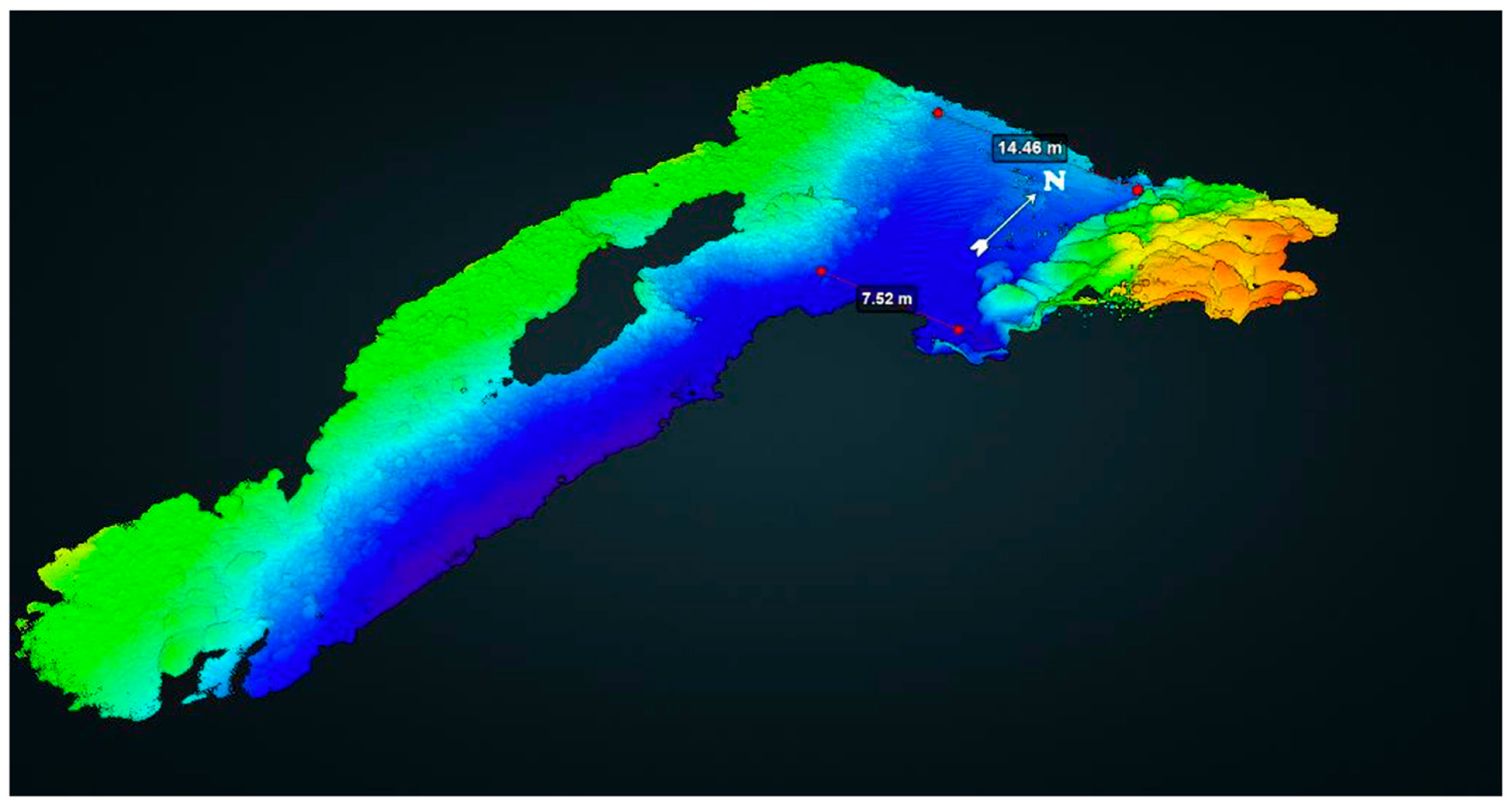
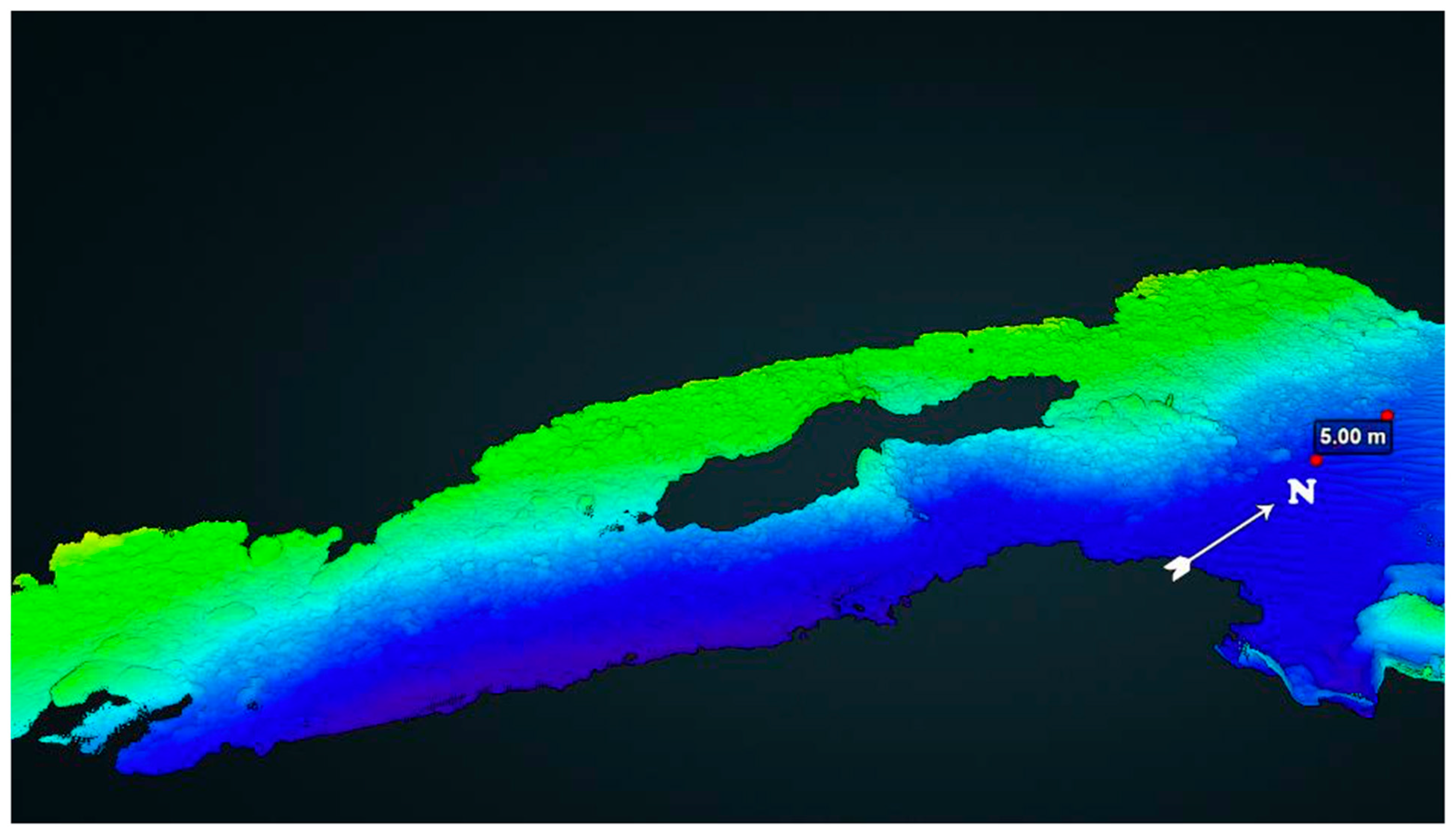
The remains of Sebastos are located by the coast near modern-day Caesarea, just south of the Carmel coast (
Figure 1 inset). Of the three original basins of the ancient harbour, the inner (shallow) basin silted up and is now completely landlocked (
Figure 1a). The middle and outer basins are located in the open sea at depths of up to 9 m (
Figure 1b,c). The harbour’s massive breakwaters (
Figure 1d,e) and associated structures, which protected these basins, are now submerged, and the debate concerning the circumstances behind the collapse of the harbour currently favours the impact of high-energy winter storms, rather than tectonic activity, tsunami events, or a rise in relative sea levels [
2,
3].
Early surveys of the site were conducted by the Palestine Exploration Fund in the early 1880s. The first underwater excavations of the harbour were headed by A.D. Link in 1960. Between the years 1963 and 1972, excavations were conducted on behalf of the Underwater Exploration Society of Israel, headed by E. Linder. From 1975 to 2005, the harbour and the city were excavated and studied by the Recanati Institute of Maritime Studies at the University of Haifa, headed by A. Raban and Y. Porat on behalf of the Israel Antiquities Authority. No significant changes in the local landscape have been registered between the beginning of archaeological work in Caesarea and now.
Raban [
4] summarised the historical and archaeological studies concerning the operation of the harbour and its decline, conjecturing that the deterioration of the outer basin began in the 1st century CE and the siltation of the inner basin started in the 2nd century CE. During the early 6th century CE, Procopius of Gaza wrote the following: “The harbour of the city named after Caesar had disintegrated through age and lay open to every threat from the sea. Its structure no longer measured up to the category of harbour, but of its former condition it kept the name alone”. Procopius refers to the Byzantine emperor Anastasius I (491–518 CE), who provided resources to repair the harbour, though the project was probably meant as an act of munificence and was, therefore, basic and far from long-lasting [
5,
6].
Relying on numismatic evidence, Ringel [
7] and Hohlfelder [
8] suggested that the harbour remained operational during the 3rd–5th centuries CE. Based on botanical remains of crops species collected in the eastern basin, Ramsay [
9] suggested that maritime activity took place there in the 4th–6th century CE. A study of shipwreck remains discovered on the breakwaters of the western basin [
4] revealed a wreck with amphoras of types that were in use from the end of the 2nd century CE until the end of the 3rd century CE. Thus, Raban inferred that during the 3rd–4th centuries CE, the breakwaters were already partly ruined and the main breakwater had deteriorated, proposing that the western basin of the harbour underwent tectonic subsidence.
Later studies reported on a cargo of lead ingots found in area K, at the northern end of the main breakwater, and dated it to the years 83–96 CE according to inscriptions [
10]. The excavators assumed that the ingots originated from a shipwreck on the breakwater and suggested that this part of the port ceased to function about a hundred years after its construction.
Strikingly, these are, in sum, the hypotheses available for modern research regarding the harbour of Sebastos and research questions related to it. Crude generalisations regarding function and maintenance and the low resolution of chronological data are accompanied by the lack of a reliable plan for the site, which should be a mandatory initial step in evaluating every aspect related to the harbour.
Previous research, based on visual surveys and focused excavations, has invested significant efforts in studying the remains of Sebastos, to the effect of identifying the general function of many of its structures, now partly or fully submerged (for orientation, see
Figure 1 above), as follows:
The south-western breakwater of the Herodian harbour, extending to a length of c. 650 m, built of Hydraulic concrete, following the instructions of Vitruvius [
11].
The northern sea-wall breakwater of the Herodian harbour, extending to a length of c. 250 m, built of Hydraulic concrete, following the instructions of Vitruvius [
11].
The quay of the Hellenistic northern harbour, built of headers, and described by Raban.
Harbour wharfs in the central basin, built on the kurkar ridge. Next to them, a Roman quay was built of headers on the south-western side of this basin. Another quay was excavated by Raban on the north-eastern side of this basin and was dated to the Herodian period.
A surface built of large ashlars—this surface was discovered in the western basin at a depth of more than 5 m. This structure was interpreted as a submerged pavement, supposedly indicating that the western basin of the harbour underwent tectonic subsidence and could no longer function as a port.
Roman harbour installations in the eastern basin—a Roman mooring stone and staircase leading to it were found on the eastern quay of the eastern basin.
A Crusader mole in the northern part of the central basin. The Crusader mole was built of pillars in secondary use, placed on a flat rocky surface.
Abrasion platforms—north and south of the harbour, the coastal aeolianite sandstone ridge was abraded by the sea.
Beach rock north of the northern Crusader wall. A 50 m long deposit of beach rock, with Roman marble chanks trapped in it, is attached to the kurkar rock at the present-day sea-level elevation.
Beach rock ridge in the north anchorage. A massive strip of beach rock deposit, about 2.8 m thick, is at 0.2–3.0 m below the present sea level. The deposit is located parallel to the coast, some 60 m west of the present shore and the remains of the aqueduct foundations. This beach rock probably marks the location of the ancient coastline before the construction of the harbour and the aqueduct.
So far, however, technological limitations have not allowed researchers to generate a high-resolution plan of the entire array of structures, and multiple questions concerning the site’s plan, function, chronology, and decline were bound to remain unanswered or at least hotly debated. The area of the entry channel to the harbour, while partially covered by the campaigns described above, thus remains, as of yet, far from fully explored and understood, thus serving as the focus of the present investigation (for the coverage of past and current projects, see
Figure 2).
Through the generation and analysis of new underwater 3D multimodal data, the
Caesarea SubMaritima project seeks to retrace the site’s history at a resolution far higher than ever available before and to produce solutions to these and other problems pertaining to local and regional economic systems. The project has been launched at the opportune moment, when the fusion of underwater multimodal remote sensing capabilities, including photogrammetric 3D modelling [
13], sub-bottom profiling [
14], shallow water frequency-domain electromagnetic (FDEM) methods [
15], and multi-beam surveys [
16], is becoming not only sufficiently accurate and available, but also practiced and tested by the leading edge of the research community in select projects of relevance [
17].
For studying the functionality of the harbour, the type and size of ships it would have been able to host, and the key processes in its decline and collapse, we identified the harbour’s entrance as a key feature and useful proxy, therefore designating its investigation as the first stage of our project. Accordingly, we aimed initially to record the main features of the harbour’s entrance, the extremities of the two breakwaters which create its entry channel, the debris scattered along this channel, and the structures placed just outside of the harbour’s entrance. Thus, we will contribute to documenting the collapse process that more specifically affected key port areas. The results presented here emerge from the initial phase of the
Caesarea SubMaritima project. They comprise 3D photogrammetric models focusing on the entrance to the harbour of Sebastos, designated by previous researchers as areas G and K, as well as on two blocks of stone on which colossal statues stood, according to historical sources (
Figure 2). These results also serve as a successful proof of concept for the project as a whole.
2. Methods
Alternative approaches for modelling submerged structures exist and have been considered thoroughly by our team and others engaged in similar projects elsewhere, yet none of them have proven able to produce the combination of viability and high-quality results that diver-borne photogrammetry offers. Employing a large Remotely Operated Vehicle (ROV) from a survey vessel would be too costly and not very efficient, mostly on account of its limited manoeuvrability. A small ROV could be deployed from the coast or from a vessel, but the shallow depths at which the site is located, combined with the high energy of the sea, currents, waves, and winds, render this option impractical. The camera and lighting system of a small ROV would not produce the same resolution obtainable with diver-borne systems. Furthermore, the features of the site would challenge ROV tether management, as well as communications with the USBL transceiver and the accurate positioning of the ROV underwater.
A multibeam survey would deliver accurate bathymetric information that could be processed to produce a digital elevation model (DEM). However, smaller features might not be recognised by this technology, and multiple individual elements of the surveyed construction would not be identified through a DEM alone, whereas photogrammetry would deliver both a DEM and unambiguous visual information, facilitating a detailed assessment of specific features. For all of these reasons, the latter technology is the one adopted by Caesarea SubMaritima.
The research presented here leverages cutting-edge methodologies, benefitting from recent advancements in high-resolution three-dimensional underwater documentation and modelling technologies. Key to this project is the utilisation of high-performance Geographic Information System (GIS) software (QGIS 3.42.2), able to compile, analyse, and present large-scale, densely populated datasets. Additionally, Computer Assisted Design (CAD) software (AutoCAD 39) plays a pivotal role, enabling computational, non-destructive procedures for engineering failure analysis. Such methodologies have been employed successfully in recent relevant projects, which shed revealing light, for example, on the history of Methoni Bay and of the ancient harbour of Aegina, Greece [
14,
18].
In the initial phase of the project, a comprehensive underwater 2D data acquisition campaign was undertaken by a team of survey divers employing multiple cameras, synchronised with lighting systems and prefabricated custom calibration targets. This methodology ensured the continuous capture of images of submerged harbour components at a rate of three frames per second (FPS). The subsequent processing of these 2D images utilised Agisoft Metashape (2.2.0), a software implementing Structure-from-Motion (SfM) algorithms to author 3D models within the GIS framework.
The resulting 3D dense point clouds were geo-rectified using ESRI ArcMAP GIS software (10.8.2), facilitating the creation of Digital Elevation Models (DEMs) with precise x, y, and z coordinates per pixel. The initial 3D models also yielded quantitative insights in the form of architectural element evaluations at a level of precision and confidence previously unattainable. By circumscribing the modelled remnants through polygons and factoring in the three-dimensional surfaces of these elements, we approximated the volumetric content within the modelled zones. For computational expediency, our current methodology adopted the mean seabed elevation for each area, omitted potential subsurface remnants, and excluded plausible water-filled interstices amid remains.
Through the integration of these complementary techniques and their application to the Sebastos harbour entrance area, a detailed digital model of the area’s various components was meticulously crafted. This model was subjected to a comprehensive analysis, incorporating insights from Roman harbour archaeology, pertinent historical evidence, and data from previous archaeological campaigns. Furthermore, part of our team had previously participated in the Azure Window project, where a well-documented natural arch on the west coast of the island of Gozo (Malta) recently collapsed [
13]. The project used similar 3D technologies to the ones now employed in Caesarea and managed to document complex underwater geomorphologies, produce an accurate high-resolution geomorphic plan of the site, and reconstruct the process of the collapse—all methodologies for which have now been employed in the Caesarea project.
3. Results
Analysis of the initial models of the harbour’s entrance area identifies distinct construction and collapse patterns flanking the entry channel (
Figure 3). Eastward of the channel lies the terminus of the northern breakwater, characterised by substantial hewn stone blocks, some reaching a length of 3 m (
Figure 4). Evidently, these blocks have shifted and slid, undergoing westward displacement over time. In stark contrast, the southern breakwater, positioned west of the channel, manifests an extensive scatter of rubble, devoid of discernible architectural attributes (
Figure 5). These observations underscore critical unresolved aspects concerning the different construction phases of Sebastos and their implications for the design and functionality of the harbour entrance.
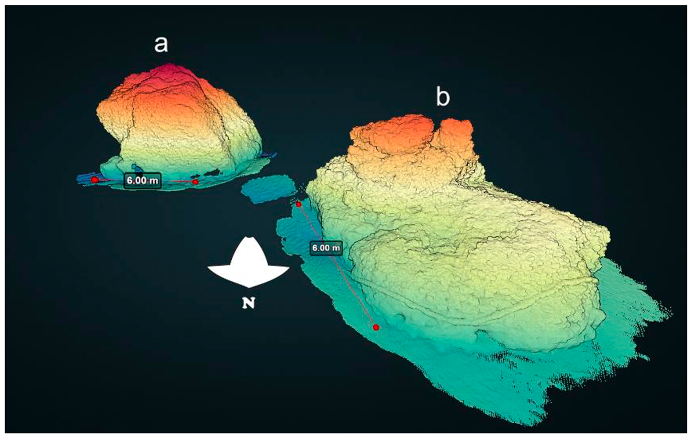
The entrance constituted a key area of the Herodian concrete-built outer basin. Historical accounts by Josephus [
19] indicate that monumental statues embellished the two structures standing just outside of the harbour’s entrance, extending a salutation to incoming vessels. Our analysis of the three-dimensional model of these structures shows them as presently measuring six by six meters and towering six meters above the seabed, at a depth of 8.6 m (
Figure 6). A near 100% coverage of these structures by the bivalve
Spondylus spinosus is detected through analysis of the model, suggesting novel directions of research into the interaction between artificial structures and the marine environment throughout the ages.
In addition, our volumetric calculations add valuable information for the study of the harbour’s entrance. At the westernmost extremity of the northern breakwater, positioned at an average seabed depth of 7.6 m, a spatial expanse of 92.8 square meters is modelled, within which remnants occupy a volume of 221.7 cubic meters (
Figure 3). Correspondingly, at the northern extremity of the southern breakwater, where the mean seafloor depth is 7.3 m, the modelled area of 97.3 square meters accommodates remains with a volume of 94 cubic meters (
Figure 4). In reference to the remnants of the western structure outside of the entrance, located at an average seabed depth of 7.4 m, a discernible volume of 61.8 cubic meters is evident above the seafloor (
Figure 6a). The remains of the eastern structure next to it, positioned at an average seabed depth of 8 m, exhibit an elevated volume of 148.8 cubic meters above the seafloor (
Figure 6b). These quantifications may be refined as additional sectors of the harbour’s remains undergo modelling.
4. Discussion and Conclusions
The width and the depth of the entrance channel between the extremities of the northern and southern breakwaters were crucial parameters that allowed merchantmen to pass [
20,
21]. Depth was a critical parameter, as it could prevent large vessels with a significant draught from entering the harbour. Thus, in many instances, they had to moor offshore and unload their merchandise, like at many other harbours such as Ostia [
22,
23]. A mosaic found at this port displays a scene showing how difficult this task was—a docker, walking cautiously on a gangway, carries a heavy amphora on his shoulder, from a sea-going freighter onto a
caudicaria, a craft that sailed along the river Tiber [
24]. Although recent investigations have allowed for a better understanding of the harbour system of Ostia, more precisely the capacity of the streams that connected the settlement to the capital city [
25], the situation is less clear for Caesarea. The initial study of the remains stated that the depth of the harbour was shallow, preventing vessels with a draught exceeding 2 m from entering [
26]. Recent drills and probes have shown that the depth was much more significant, actually reaching 6 m, showing that large merchantmen could enter the Herodian port [
27].
Entering harbours was a particularly challenging manoeuvre for unoared sailing vessels, which could potentially cause accidents with devastating consequences, as a shipwreck could obstruct the harbour entrance and suspend traffic, requiring tremendous efforts to remove it. For this reason, commercial vessels required the assistance of smaller oared boats similar to the tugboat displayed in the Rimini mosaic [
28,
29]. The extremities of breakwaters, protruding into the sea, were exposed to storms. Debris lying on the harbour bottom could likewise obstruct its entrance, which was dangerous for sailing ships. Harbour authorities aiming to mitigate these damages usually reinforced the structures at the entrance. The case is clearly evidenced in Frejus [
30]. A recent investigation on a caisson located at the entrance of the Herodian harbour of Caesarea revealed a similar attempt to repair or reinforce the end of the northern breakwater in the second century CE, revealing that the port still enjoyed prosperity in that period [
16].
The results presented here provide a new baseline for the mapping of the harbour entrance, which will be expanded to additional areas of the harbour and serve as a basis for gathering further multimodal remote sensing data. A close comparison between the newly identified elements as they appear in
Figure 4 and
Figure 5 indicates, firstly, that the two main seawalls bracketing the harbour’s entrance, and possibly also the superstructure imposed on them, were constructed by employing different architectural styles, and, therefore, were likely constructed during different stages of the harbour’s activity. Arguably, the original Herodian structures are represented in the northern breakwater, which employed large-scale ashlar masonry, comprising massive blocks measuring up to three meters in length (
Figure 4). This architectural style is familiar from other Roman sites along the local coast, such as elements in the temple platforms of the adjacent Dor. The part of the southern breakwater that formed the western facet of the harbour’s entrance, on the other hand, presents far less defined architectural characteristics, defined above as an extensive scatter of rubble, and may be approached as a later renovation project, aiming to solidify a collapsing part of the entrance channel (
Figure 5).
Secondly, as far as the functionality of the harbour’s entrance is concerned, it is noteworthy that the actual entry channel still remains wide and deep enough today for the passage of larger vessels of antiquity, despite the partial collapse of the walls comprising it on both sides. Together with the possible renovation in antiquity of the northern extremity of the southern breakwater, it may be assumed that the functionality of the harbour was not diminished on account of the deterioration in the condition of the harbour’s entrance, but possibly following the collapse of other parts of the breakwaters, most likely the southern one, which was the most exposed to the energy of winter storms attacking it from the southwest. A passage from Procopius Gazaeus [
31], dated to the early 6th century, reinforces this notion, as follows:
“The port of the city named after Caesar had fallen into bad condition in the course of time and became exposed to the waves, no longer deserving in fact to be titled a port but preserving merely its name from its former fortune. But you (Anastasius) did not ignore the city’s prayers and laments over the ships which, escaping the sea, were wrecked in the harbour itself. […] Thanks to your decision the city was rejuvenated and receives ships without fear and is provided for its basic requirements.”
This passage, which refers to Emperor Anastasius’ act of munificence in renovating the dysfunctional Sebastos, clearly refers to ships already passing into the harbour through its entrance, only to be wrecked while in it due to the facility’s lack of sufficient protection.
Further investigation is to be carried out on the harbour’s original building techniques and resources, function, collapse processes, and possible renovation efforts, centred, among other things, also on the obtainment and transportation of spolia from elsewhere in Caesarea, as well as from neighbouring settlements such as the city of Dor, whose ancient centre on the tell, as well as its coastal structures and facilities, also saw serious decline from the 3rd century onward [
32].


