
Submarine Morphological Description of the Ancient Archipelagic Aprons in the Marcus–Wake Seamount Group, Northwestern Pacific Ocean

 ,
,  , , ,
, , ,
Abstract
1. Introduction
2. Geological Background
3. Data and Methods
4. Results
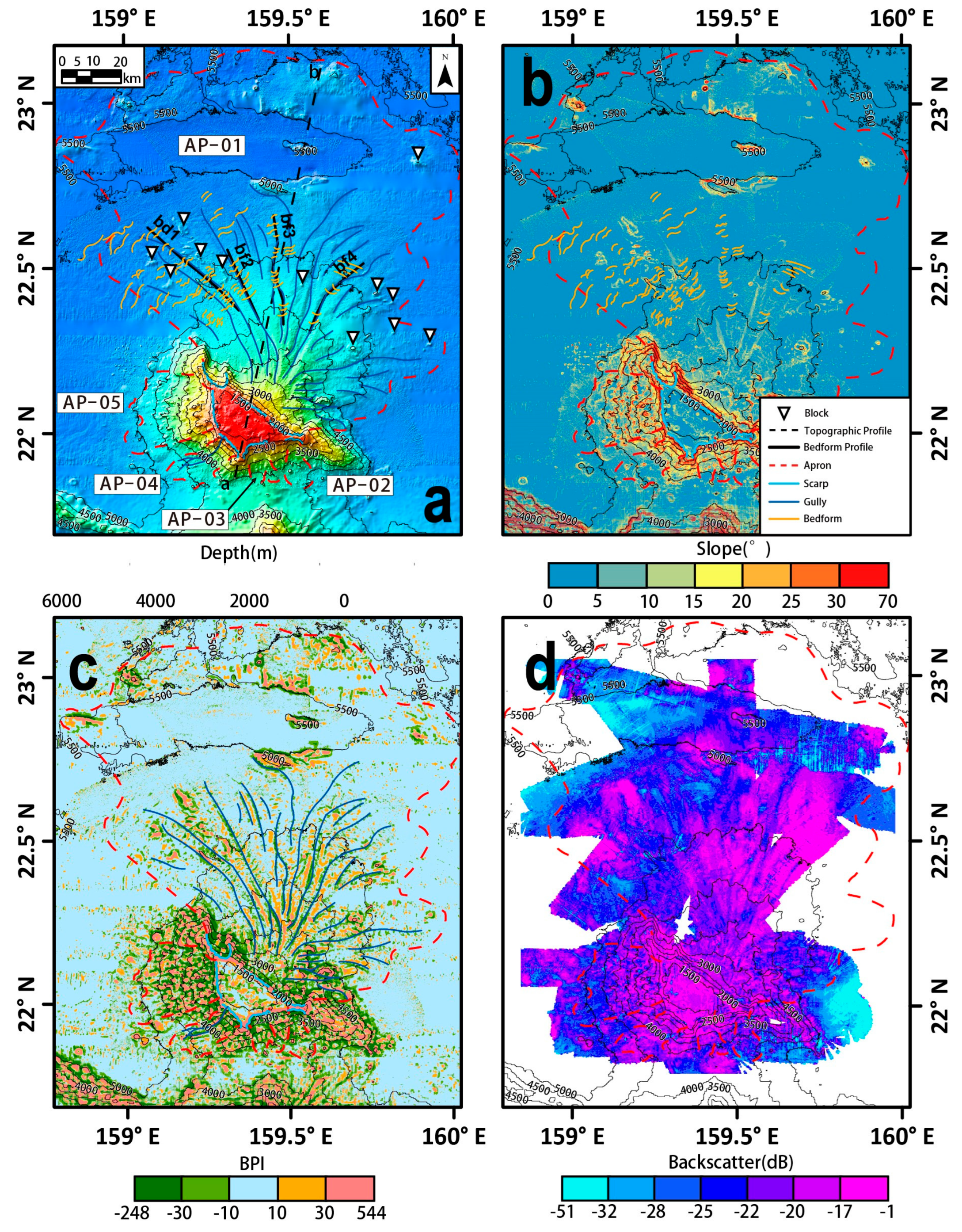
4.1. Suda Guyot
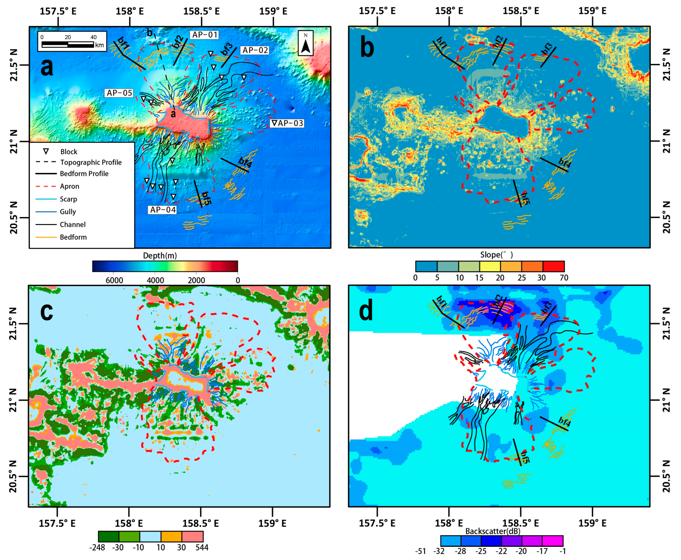
4.2. Arnold Guyot
4.3. Lamont Guyot
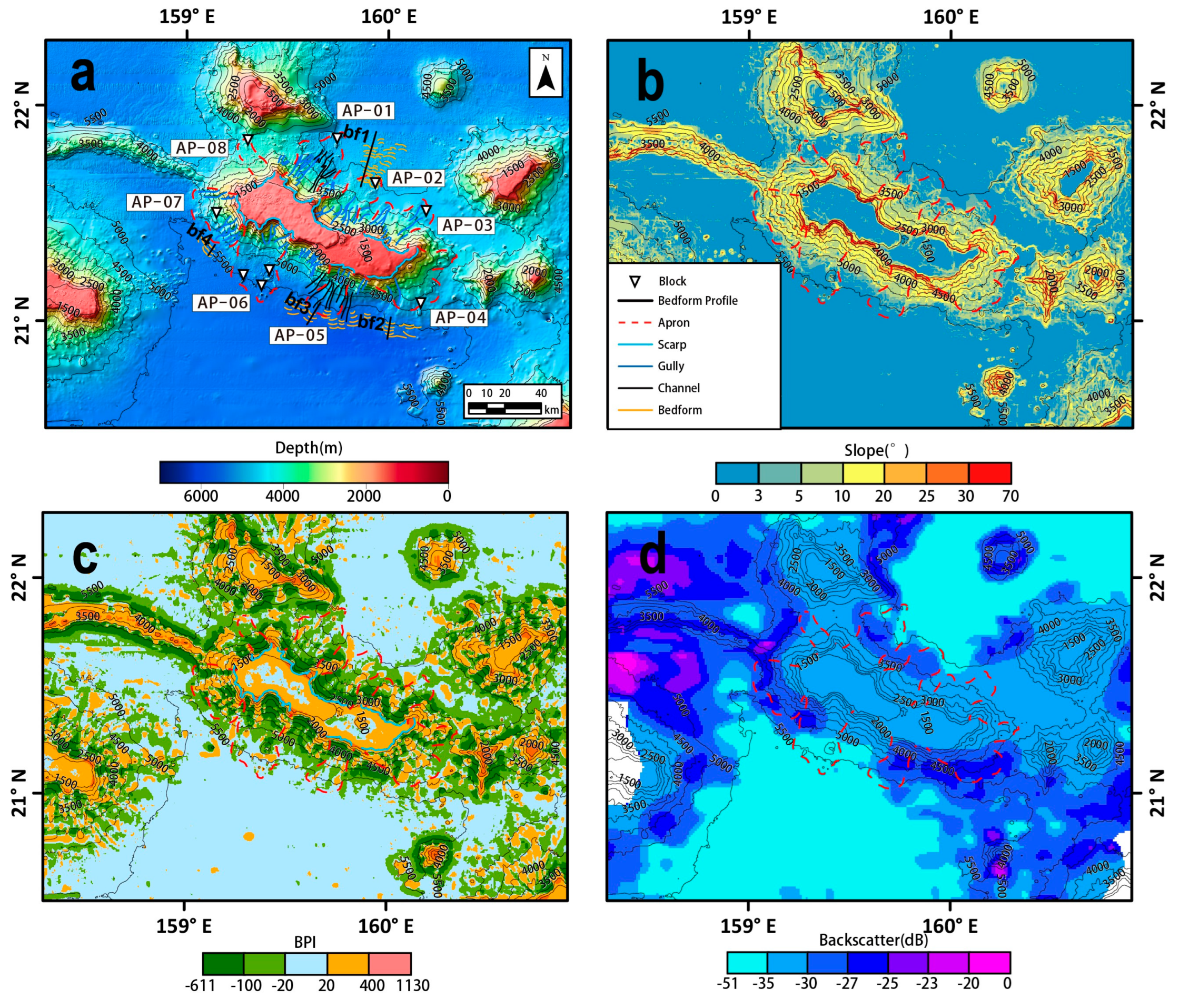
4.4. Niulang Guyot
4.5. Zhinyv Guyot
5. Discussion
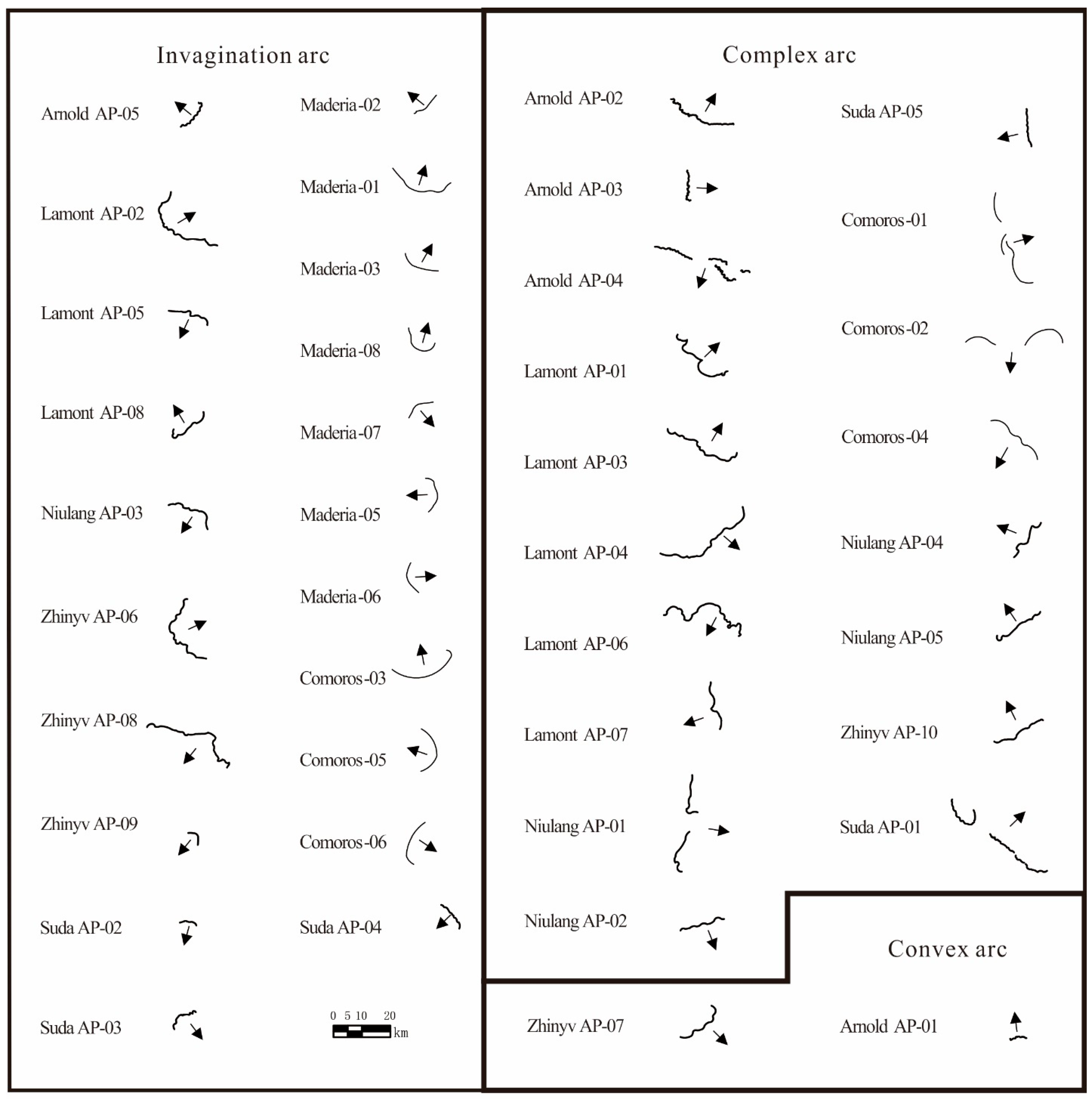
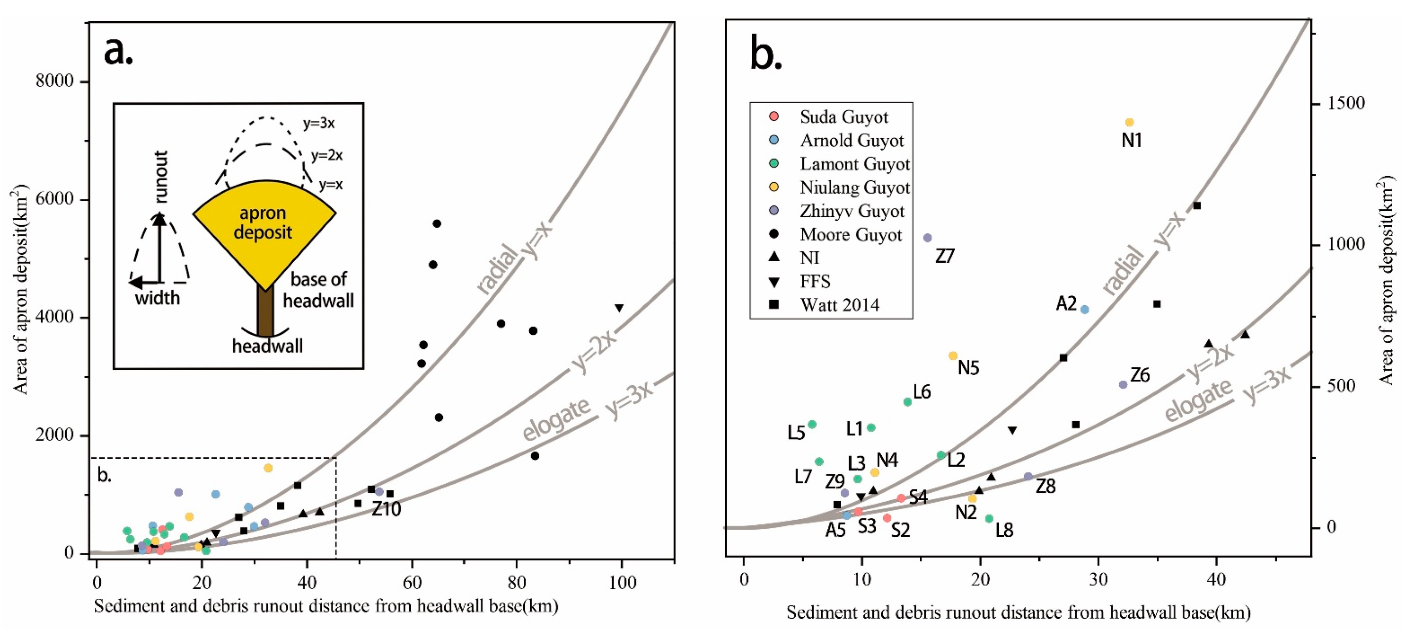
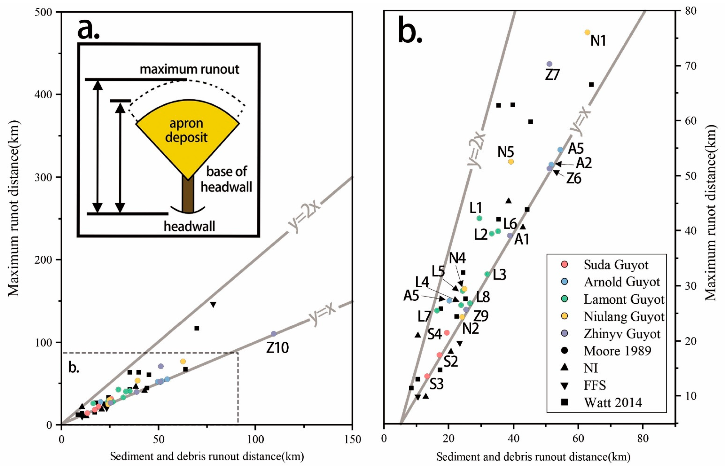
5.1. Landslide Processes and Their Constraints on the Archipelagic Aprons
5.2. Scarp Morphologies and Relations with the Domain of the Archipelagic Aprons
5.3. Gully/Channel Morphology and Occurrence
5.4. Sediment Waves on the Bedforms
6. Conclusions
Supplementary Materials
Author Contributions
Funding
Institutional Review Board Statement
Informed Consent Statement
Data Availability Statement
Acknowledgments
Conflicts of Interest
References
- Buchs, D.M.; Cukur, D.; Masago, H.; Garbe-Schönberg, D. Sediment Flow Routing during Formation of Forearc Basins: Constraints from Integrated Analysis of Detrital Pyroxenes and Stratigraphy in the Kumano Basin, Japan. Earth Planet. Sci. Lett. 2015, 414, 164–175. [Google Scholar] [CrossRef]
- Seton, M.; Müller, R.D.; Zahirovic, S.; Gaina, C.; Torsvik, T.; Shephard, G.; Talsma, A.; Gurnis, M.; Turner, M.; Maus, S.; et al. Global Continental and Ocean Basin Reconstructions since 200 Ma. Earth Sci. Rev. 2012, 113, 212–270. [Google Scholar] [CrossRef]
- Gardner, J.V.; Calder, B.R.; Armstrong, A.A. Geomorphometric Descriptions of Archipelagic Aprons off the Southern Flanks of French Frigate Shoals and Necker Island Edifices, Northwest Hawaiian Ridge. GSA Bull. 2021, 133, 2189–2209. [Google Scholar] [CrossRef]
- Koppers, A.A.P.; Staudigel, H.; Duncan, R.A. High-Resolution 40Ar/9Ar Dating of the Oldest Oceanic Basement Basalts in the Western Pacific Basin: PACIFIC BASIN 40AR/39AR DATING. Geochem. Geophys. Geosyst. 2003, 4. [Google Scholar] [CrossRef]
- Hein, J.R.; Mizell, K.; Koschinsky, A.; Conrad, T.A. Deep-Ocean Mineral Deposits as a Source of Critical Metals for High- and Green-Technology Applications: Comparison with Land-Based Resources. Ore Geol. Rev. 2013, 51, 1–14. [Google Scholar] [CrossRef]
- Hein, J.; Koschinsky, A. Deep-Ocean Ferromanganese Crusts and Nodules. Treatise Geochem. Second. Ed. 2014, 13, 273–291. [Google Scholar] [CrossRef]
- Li, Z.; Li, H.; Hein, J.R.; Dong, Y.; Wang, M.; Ren, X.; Wu, Z.; Li, X.; Chu, F. A Possible Link between Seamount Sector Collapse and Manganese Nodule Occurrence in the Abyssal Plains, NW Pacific Ocean. Ore Geol. Rev. 2021, 138, 104378. [Google Scholar] [CrossRef]
- Agogué, H.; Lamy, D.; Neal, P.R.; Sogin, M.L.; Herndl, G.J. Water Mass-Specificity of Bacterial Communities in the North Atlantic Revealed by Massively Parallel Sequencing: Bacterial Assemblages in North Atlantic Ocean. Mol. Ecol. 2011, 20, 258–274. [Google Scholar] [CrossRef] [PubMed]
- Baines, A.G.; Cheadle, M.J.; Dick, H.J.B.; Scheirer, A.H.; John, B.E.; Kusznir, N.J.; Matsumoto, T. Mechanism for Generating the Anomalous Uplift of Oceanic Core Complexes: Atlantis Bank, Southwest Indian Ridge. Geology 2003, 31, 1105–1108. [Google Scholar] [CrossRef]
- Vogt, P.R.; Smoot, N.C. The Geisha Guyots: Multibeam Bathymetry and Morphometric Interpretation. J. Geophys. Res. 1984, 89, 11085–11107. [Google Scholar] [CrossRef]
- Staudigel, H.; Koppers, A.; Plank, T.; Hanan, B. Seamounts in the Subduction Factory. Oceanography 2010, 23, 176–181. [Google Scholar] [CrossRef]
- Tzevahirtzian, A.; Zaragosi, S.; Bachèlery, P.; Biscara, L.; Marchès, E. Submarine Morphology of the Comoros Volcanic Archipelago. Mar. Geol. 2021, 432, 106383. [Google Scholar] [CrossRef]
- Locat, J.; Lee, H.J. Submarine Landslides: Advances and Challenges. Can. Geotech. J. 2002, 39, 193–212. [Google Scholar] [CrossRef]
- Watt, S.; Talling, P.; Hunt, J. New Insights into the Emplacement Dynamics of Volcanic Island Landslides. Oceanography 2014, 27, 46–57. [Google Scholar] [CrossRef]
- Babonneau, N.; Delacourt, C.; Cancouët, R.; Sisavath, E.; Bachèlery, P.; Mazuel, A.; Jorry, S.J.; Deschamps, A.; Ammann, J.; Villeneuve, N. Direct Sediment Transfer from Land to Deep-Sea: Insights into Shallow Multibeam Bathymetry at La Réunion Island. Mar. Geol. 2013, 346, 47–57. [Google Scholar] [CrossRef]
- Babonneau, N.; Villeneuve, N.; Mazuel, A.; Bachèlery, P. Erosion and Volcaniclastic Sedimentation at Piton de La Fournaise: From Source to Deep Marine Environment. In Active Volcanoes of the Southwest Indian Ocean; Bachelery, P., Lenat, J.-F., Di Muro, A., Michon, L., Eds.; Active Volcanoes of the World; Springer: Berlin/Heidelberg, Germany, 2016; pp. 71–90. ISBN 978-3-642-31394-3. [Google Scholar]
- Quartau, R. Gravitational, Erosional and Depositional Processes on Volcanic Ocean Islands: Insights from the Submarine Morphology of Madeira Archipelago. Earth Planet. Sci. Lett. 2018, 482, 288–299. [Google Scholar] [CrossRef]
- Bulmer, M.H.; Wilson, J.B. Comparison of Flat-Topped Stellate Seamounts on Earth’s Seafloor with Stellate Domes on Venus Using Side-Scan Sonar and Magellan Synthetic Aperture Radar. Earth Planet. Sci. Lett. 1999, 171, 277–287. [Google Scholar] [CrossRef]
- Cartigny, M.J.B.; Postma, G.; van den Berg, J.H.; Mastbergen, D.R. A Comparative Study of Sediment Waves and Cyclic Steps Based on Geometries, Internal Structures and Numerical Modeling. Mar. Geol. 2011, 280, 40–56. [Google Scholar] [CrossRef]
- Watt, S.F.L.; Talling, P.J.; Vardy, M.E.; Masson, D.G.; Henstock, T.J.; Hühnerbach, V.; Minshull, T.A.; Urlaub, M.; Lebas, E.; Le Friant, A.; et al. Widespread and Progressive Seafloor-Sediment Failure Following Volcanic Debris Avalanche Emplacement: Landslide Dynamics and Timing Offshore Montserrat, Lesser Antilles. Mar. Geol. 2012, 323–325, 69–94. [Google Scholar] [CrossRef]
- Laberg, J.S.; Vorren, T.O. The Trñnadjupet Slide, Offshore Norway Ð Morphology, Evacuation and Triggering Mechanisms. Mar. Geol. 2000, 171, 95–144. [Google Scholar] [CrossRef]
- Symons, W.O.; Sumner, E.J.; Talling, P.J.; Cartigny, M.J.B.; Clare, M.A. Large-Scale Sediment Waves and Scours on the Modern Seafloor and Their Implications for the Prevalence of Supercritical Flows. Mar. Geol. 2016, 371, 130–148. [Google Scholar] [CrossRef]
- Voosen, P. A ‘Mind Boggling’ 19,000 Seamounts Discovered. Science 2023, 380, 226–227. [Google Scholar] [CrossRef] [PubMed]
- Santos, R.; Quartau, R.; da Silveira, A.B.; Ramalho, R.; Rodrigues, A. Gravitational, Erosional, Sedimentary and Volcanic Processes on the Submarine Environment of Selvagens Islands (Madeira Archipelago, Portugal). Mar. Geol. 2019, 415, 105945. [Google Scholar] [CrossRef]
- Usui, Y.; Yamazaki, T.; Saitoh, M. Changing Abundance of Magnetofossil Morphologies in Pelagic Red Clay Around Minamitorishima, Western North Pacific. Geochem. Geophys. Geosyst. 2017, 18, 4558–4572. [Google Scholar] [CrossRef]
- Müller, R.D.; Seton, M.; Zahirovic, S.; Williams, S.E.; Matthews, K.J.; Wright, N.M.; Shephard, G.E.; Maloney, K.T.; Barnett-Moore, N.; Hosseinpour, M.; et al. Ocean Basin Evolution and Global-Scale Plate Reorganization Events Since Pangea Breakup. Annu. Rev. Earth Planet. Sci. 2016, 44, 107–138. [Google Scholar] [CrossRef]
- Pilet, S.; Abe, N.; Rochat, L.; Kaczmarek, M.-A.; Hirano, N.; Machida, S.; Buchs, D.M.; Baumgartner, P.O.; Müntener, O. Pre-Subduction Metasomatic Enrichment of the Oceanic Lithosphere Induced by Plate Flexure. Nat. Geosci. 2016, 9, 898–903. [Google Scholar] [CrossRef]
- Kaneda, K.; Kodaira, S.; Nishizawa, A.; Morishita, T.; Takahashi, N. Structural Evolution of Preexisting Oceanic Crust through Intraplate Igneous Activities in the Marcus-Wake Seamount Chain. Geochem. Geophys. Geosyst. 2010, 11, 2010GC003231. [Google Scholar] [CrossRef]
- Janney, P.E.; Castillo, P.R. Isotope Geochemistry of the Darwin Rise Seamounts and the Nature of Long-Term Mantle Dynamics beneath the South Central Pacific. J. Geophys. Res. 1999, 104, 10571–10589. [Google Scholar] [CrossRef]
- Smith, W.H.F.; Staudigel, H.; Watts, A.B.; Pringle, M.S. The Magellan Seamounts: Early Cretaceous Record of the South Pacific Isotopic and Thermal Anomaly. J. Geophys. Res. 1989, 94, 10501–10523. [Google Scholar] [CrossRef]
- Smoot, N.C. The Marcus-Wake Seamounts and Guyots as Paleofracture Indicators and Their Relation to the Dutton Ridge. Mar. Geol. 1989, 88, 117–131. [Google Scholar] [CrossRef]
- Dutkiewicz, A.; Müller, R.D.; O’Callaghan, S.; Jónasson, H. Census of Seafloor Sediments in the World’s Ocean. Geology 2015, 43, 795–798. [Google Scholar] [CrossRef]
- Nakanishi, M. Topographic Expression of Five Fracture Zones in the Northwestern Pacific Ocean. In Geophysical Monograph Series; Pringle, M.S., Sager, W.W., Sliter, W.V., Stein, S., Eds.; American Geophysical Union: Washington, DC, USA, 1993; Volume 77, pp. 121–136. ISBN 978-0-87590-036-0. [Google Scholar]
- Becker, J.J.; Sandwell, D.T.; Smith, W.H.F.; Braud, J.; Binder, B.; Depner, J.; Fabre, D.; Factor, J.; Ingalls, S.; Kim, S.-H.; et al. Global Bathymetry and Elevation Data at 30 Arc Seconds Resolution: SRTM30_PLUS. Mar. Geod. 2009, 32, 355–371. [Google Scholar] [CrossRef]
- Geldmacher, J.; van den Bogaard, P.; Hoernle, K.; Schmincke, H.-U. The 40Ar/39Ar Age Dating of the Madeira Archipelago and Hotspot Track (Eastern North Atlantic): The 40Ar/39Ar age dating. Geochem. Geophys. Geosyst. 2000, 1. [Google Scholar] [CrossRef]
- Pelleter, A.-A.; Caroff, M.; Cordier, C.; Bachelery, P.; Nehlig, P.; Debeuf, D.; Arnaud, N. Melilite-Bearing Lavas in Mayotte (France): An Insight into the Mantle Source below the Comores. Lithos 2014, 208–209, 281–297. [Google Scholar] [CrossRef]
- Kostaschuk, R.; Villard, P. Flow and Sediment Trans-Port over Large Subaqueous Dunes: Fraser River, Canada. Sedimentology 1996, 43, 849–863. [Google Scholar] [CrossRef]
- Bergersen, D.D. Geology and Geomorphology of Wodejebato (Sylvania) Guyot, Marshall Islands. In Geophysical Monograph Series; Pringle, M.S., Sager, W.W., Sliter, W.V., Stein, S., Eds.; American Geophysical Union: Washington, DC, USA, 1993; Volume 77, pp. 367–385. ISBN 978-0-87590-036-0. [Google Scholar]
- Camoin, G.F.; Arnaud-Vanneau, A.; Bergersen, D.D.; Enos, P.; Ebren, P. Development and Demise of Mid-Oceanic Carbonate Platforms, Wodejebato Guyot (NW Pacific). In Reefs and Carbonate Platforms in the Pacific and Indian Oceans; Camoin, G.F., Davies, P.J., Eds.; Blackwell Publishing Ltd.: Oxford, UK, 2009; pp. 39–67. ISBN 978-1-4443-0487-9. [Google Scholar]
- Moore, J.G. Prodigious Submarine Landslides on the Hawaiian Ridge. Int. J. Rock Mech. Min. Sci. Geomech. Abstr. 1990, 27, 220. [Google Scholar] [CrossRef]
- Masson, D.G.; Watts, A.B.; Gee, M.J.R.; Urgeles, R.; Mitchell, N.C.; Le Bas, T.P.; Canals, M. Slope Failures on the Flanks of the Western Canary Islands. Earth-Sci. Rev. 2002, 57, 1–35. [Google Scholar] [CrossRef]
- McGuire, W.J. Volcano Instability: A Review of Contemporary Themes. Geol. Soc. Lond. Spec. Publ. 1996, 110, 1–23. [Google Scholar] [CrossRef]
- Paull, C.K.; Ussler, W., III; Caress, D.W.; Lundsten, E.; Covault, J.A.; Maier, K.L.; Xu, J.; Augenstein, S. Origins of Large Crescent-Shaped Bedforms within the Axial Channel of Monterey Canyon, Offshore California. Geosphere 2010, 6, 755–774. [Google Scholar] [CrossRef]


| Study Areas | Acquisition Time | Data Sources | Type(s) of Sonar |
|---|---|---|---|
| Suda guyot | 2018 | Chinese DY48 Cruise | EM122 |
| Arnold and Lamont guyots | 2009 | Chinese DY27 Cruise | EM122 |
| Niulang and Zhinyv guyots | 2004 | Chinese DY105-12/14 Cruise | EM122 |
Disclaimer/Publisher’s Note: The statements, opinions and data contained in all publications are solely those of the individual author(s) and contributor(s) and not of MDPI and/or the editor(s). MDPI and/or the editor(s) disclaim responsibility for any injury to people or property resulting from any ideas, methods, instructions or products referred to in the content. |
© 2024 by the authors. Licensee MDPI, Basel, Switzerland. This article is an open access article distributed under the terms and conditions of the Creative Commons Attribution (CC BY) license (https://creativecommons.org/licenses/by/4.0/).
Share and Cite
Wang, X.; Li, H.; Cheng, Y.; Yao, P.; Chu, F.; Ma, W.; Wang, H.; Lv, S.; Li, X.; Li, Z.; et al. Submarine Morphological Description of the Ancient Archipelagic Aprons in the Marcus–Wake Seamount Group, Northwestern Pacific Ocean. J. Mar. Sci. Eng. 2024, 12, 670. https://doi.org/10.3390/jmse12040670
Wang X, Li H, Cheng Y, Yao P, Chu F, Ma W, Wang H, Lv S, Li X, Li Z, et al. Submarine Morphological Description of the Ancient Archipelagic Aprons in the Marcus–Wake Seamount Group, Northwestern Pacific Ocean. Journal of Marine Science and Engineering. 2024; 12(4):670. https://doi.org/10.3390/jmse12040670
Chicago/Turabian StyleWang, Xiao, Huaiming Li, Yongshou Cheng, Pengfei Yao, Fengyou Chu, Weilin Ma, Hongyi Wang, Shihui Lv, Xiaohu Li, Zhenggang Li, and et al. 2024. "Submarine Morphological Description of the Ancient Archipelagic Aprons in the Marcus–Wake Seamount Group, Northwestern Pacific Ocean" Journal of Marine Science and Engineering 12, no. 4: 670. https://doi.org/10.3390/jmse12040670
APA StyleWang, X., Li, H., Cheng, Y., Yao, P., Chu, F., Ma, W., Wang, H., Lv, S., Li, X., Li, Z., Zhang, W., & Dong, Y. (2024). Submarine Morphological Description of the Ancient Archipelagic Aprons in the Marcus–Wake Seamount Group, Northwestern Pacific Ocean. Journal of Marine Science and Engineering, 12(4), 670. https://doi.org/10.3390/jmse12040670