Abstract
One of the sources of risk inherent to construction projects is the quality of spatial data. Damage to buried pipes and cables often causes accidents, delays, or stoppages of construction works. Fuzzy logic is a method for studying the risk. It is employed to describe complex or poorly defined phenomena that can hardly be characterised with probabilistic methods. The article proposes a method for assessing the risk of damaging underground utilities based on a fuzzy inference engine. The author first defined linguistic variables and assigned them values based on risk factors. The membership functions for the linguistic variables were modelled using expert judgement. Then, the author determined qualitative fuzzy sets with the rule base. Finally, the values were converted into crisp values. The defuzzification technique employed was the centre of gravity. The proposed method can assess the risk of damage to underground utilities for spatial data exhibiting diverse quality classes. It will be employed to generate large-scale risk maps. The proposed fuzzy logic solution is an effective and appropriate tool for assessing the risk of damage to underground utilities arising from the quality of subsurface data. It should not be regarded as a universal substitute for PRA (Probabilistic Risk Assessment) but as a complementary methodology that is particularly well-suited to risk assessment in data-poor environments characterised by epistemic uncertainty and reliance on qualitative expert judgement.
1. Introduction
Research problem. Construction projects routinely rely on spatial datasets of underground utilities that are often incomplete and uncertain in both horizontal and vertical positioning. These data quality deficiencies create a direct risk of striking and damaging buried assets during excavation. The problem addressed in this paper is how to systematically estimate that risk when probabilistic characterisation is infeasible or data are sparse by integrating three data quality factors—(i) incompleteness of the underground utility inventory (ID), (ii) horizontal accuracy (HA), and (iii) vertical accuracy (VA)—into a transparent, expert-driven fuzzyinference model that produces a crisp risk value usable for planning and risk mapping.
Objective and scope. Our objective is to design and validate a fuzzy logic risk model that quantifies the risk of damage to underground utilities attributable to spatial data quality alone; operational, human, and equipment factors are outside the present scope. We demonstrate the model across urban, suburban, and rural data quality classes and show how the outputs can support large-scale risk maps.
The notion of risk means uncertainty as to the chance of an event that may have an adverse impact on the intended goal [1]. This definition applies to qualitative methods for risk assessment based on expert knowledge and experience. Kaplan and Garrick [2] offer a quantitative definition of risk. The risk of an event is described as a triplet:
where S is an event scenario;
R = {S, P, I},
P is the probability of the event;
I is the potential impact or consequences of the event.
Risk analysis can also be considered in the context of spatial data quality analysis. Spatial data are used in a variety of projects. Their quality directly contributes to the project’s success.
Project risk can be described with a three-element diagram:
where R is the risk, C is the cause, and I is the effect (impact of the risk).
R-C-I,
Researchers analysed the problem of risk inherent to the use of spatial data in decision-making using fuzzy logic from several angles. One of them was the presence of natural threats and anthropogenic hazards. Risk analysis studies using fuzzy logic and GIS tools are mainly concerned with adverse events such as damage to hard infrastructure for energy or water transfer, failures of engineering structures, and geological, environmental, and natural disasters.
Hard infrastructure, such as power or water systems, is built and maintained in developed and developing countries. One of its primary components is water supply lines. They are difficult to manage and prone to damage and failure. Authors of [3] propose a mixed hierarchical fuzzy logic model for assessing the risk score for a water supply line. The fuzzy logic model is fed four main parameters as input data: depth, length, age, and tightness.
Reducing the number of conditions in the rule base of water supply line risk assessment models is vital because excessive sets hinder clarity and interpretation. It is a challenge to devise a large number of precise fuzzy rules because the process requires expert knowledge, while prognostic uncertainty can lead to unforeseen events [4,5,6]. Authors of [7] presented a simplified hierarchical fuzzy logic model concerning the limitation of expert-derived rules. They considered four factors critical to water supply lines with various numbers of membership functions. The proposed model involves only 95 rules, which is a small number compared to 1225 rules in traditional Mamdani fuzzy logic.
Water supply lines are designed to be installed in a single trench to limit their footprints and impact on vegetation. In [8], the authors identified a functional relationship between the total risk for a water supply system and the risk of individual lines by combining the engineering system reliability theory with mathematical induction. Moreover, they employed the fuzzy set theory and fault tree analysis to compute the probability of failure for each line in the system.
One has to analyse complex, uncertain factors to determine the risk of anti-slip instability of earth-rock dams. Traditional analytical methods usually consider them as random variables [9]. In fact, fuzziness and randomness are two inherent uncertainty factors affecting earth-rock dams’ stability. Authors of [10] developed a fuzzy model of earth-rock dam instability by comprehensively considering the randomness and fuzziness of parameters and failure criteria. They used MonteCarlo simulation and transformed fuzzy parameters into interval numbers to reach the probability threshold for the risk of instability of earth-rock dams.
The construction industry is counted among the most dangerous sectors in terms of occupational safety. Its accident rate and occupational risk are higher than for other industries. Researchers have extensively studied construction risk assessment with fuzzy methods [11,12,13,14]. However, gaining access to real-life data for probabilistic analysis is a challenge. Therefore, qualitative risk assessment methods based on expert judgement are widespread in the construction industry. Still, when combined with expert judgement, insufficient data can indeed be used to assess risk with curbed uncertainty and bias.
Publication [15] offers research aimed at improving the methodology for analysing causes and effects of failures using a multicriteria decision-making method based on a hesitant fuzzy set, which is effective when expert judgement is not unambiguous. The model can be applied to construction case studies in real-life occupational risk assessment. Authors of [16] proposed a methodology for assessing the risk involved in construction projects where epistemic uncertainty occurs (uncertainty due to missing data or incomplete knowledge). Their method employs a triangular fuzzy numbering system to compute the risk value by combining expert judgement and insufficient historical data.
Landslides are highly destructive and recurrent natural disasters that mainly threaten mountainous regions. They often cause substantial damage to local infrastructure and loss of human and animal life or land. Data-driven landslide assessment is critical for preventing the occurrence and recurrence of landslide processes [17]. Detailed soil susceptibility maps are needed to control landslide threats effectively. Such maps are employed in targeted risk management plans. Landslide susceptibility models are based mainly on fuzzy logic [18,19].
Environmental risk is considered a type of risk linked mostly to adverse environmental impact and overexploitation of natural resources. Environmental risk can be defined as a combination of the probability of an environmental event and its consequences [20,21]. Publication [22] contains a proposition of an integrated probabilistic–fuzzy model for assessing the risk of heavy metals in soil and identifying priority contaminants. The model combines probabilistic and fuzzy methods and a logical inference engine. Probabilistic–fuzzy models reduce the uncertainty of environmental risk assessment, while this model integrates environmental and health risks to provide more complete risk insight. The assessment results can be a point of reference for managers who devise targeted management and control strategies [23,24,25].
The frequency of extreme weather events has increased globally in recent years, leading to ever-intensive natural disasters that seriously threaten human life and property [26,27,28]. Flood risk studies produce risk maps central to flood risk management plans (mainly regarding reducing the risk level) [29,30]. This is achieved by combining a multicriteria decision-making model and geographical information system (GIS). They use an analytical hierarchy process (AHP) model based on a triangular fuzzy number (TFN) in a GIS environment [31,32,33].
Fuzzy logic has also been successfully applied beyond construction geoengineering, including in renewable energy planning. For example, when assessing the feasibility of tidal turbine installations, a fuzzy inference system (FIS) with a set of linguistic variables describing environmental conditions (e.g., currents, temperature, salinity, depth) is used, which enables an uncertainty-robust, integrated site assessment after defuzzification [34]. Similarly, in studies on the revitalization of the Canal of Castile, fuzzy logic made it possible to combine technical–environmental criteria with the preferences of the local community to evaluate sustainable hydropower [35]. These examples confirm the versatility and transferability of the fuzzy framework, which we also employ in this study.
The risk of damage to underground utilities is inherent to the construction process. One of the sources of this risk is the quality of spatial data. The literature [36] enumerates three main causes of damage to buried pipes and cables in the context of spatial data quality. The first cause is the presence of underground utilities on site that are not included on a site map. The source of this risk can be defined as an incomplete database. The second cause of the risk is the insufficient horizontal accuracy of pipe and cable positioning on the site map generated from spatial data from official databases. The third reason is the insufficient vertical accuracy of underground pipe and cable positioning.
If the risk occurs, its impact on the construction project can be substantial, affecting the health and safety of people in addition to material losses. Damage to buried pipes or cables can lead to accidents, delays, or even stoppages.
Probabilistic, Bayesian, and Fuzzy Approaches—ACritical Synthesis
In risk analysis there are three complementary strands for modelling uncertainty: (i) probabilistic (PRA), (ii) Bayesian, and (iii) fuzzy. PRA treats uncertainty primarily as randomness (aleatory) and requires stable, representative data to estimate probability distributions and reliably quantify event frequencies. It yields values directly interpretable as probabilities, but it can be sensitive to assumptions (e.g., independence, stationarity) and is harder to apply when data gaps and reporting biases—typical for underground infrastructure—are present. The Bayesian approach alleviates some of these limitations by combining data with expert knowledge via prior distributions, as well as by hierarchically modelling sources of variability; it still requires an explicit model structure and likelihood—something that, in practice, with ambiguous criteria for spatial data quality and threshold choices, can be highly subjective. Fuzzy inference, by contrast, models imprecise concepts, if–then rules, and quality thresholds directly through membership functions, which increases transparency and alignment with engineering practice; it is also naturally resilient to scarcity of hard data (dominant epistemic uncertainty). A limitation of the fuzzy approach is the lack of a direct probabilistic interpretation of the outcome and sensitivity to the choice of membership functions and rule base—hence we recommend calibration/sensitivity analysis and, where possible, data-based validation. In this paper, selecting an FIS is justified by the problem specifics: incomplete datasets, mixed characterisation of positional errors (X, Y, Z), and a strong component of expert knowledge; the fuzzy approach thus provides decision-ready risk ratings (L–M–H) while retaining transparency and future combinability with probabilistic methods. Table 1 presents the comparison criteria for the probabilistic, Bayesian, and fuzzy approaches.

Table 1.
Probabilistic, Bayesian, and fuzzy approaches—a critical synthesis.
2. Materials and Methods
2.1. Probabilistic Risk Assessment (PRA)—Method Outline
The brief explanation of the Probabilistic Risk Assessment (PRA) method will help readers compare it with the fuzzy logic approach used in the paper. PRA is a well-established probabilistic approach to risk analysis in which the risk of an event is described by the triplet R = {S, P, I}: scenario S, probability P, and consequence I (Kaplan–Garrick definition; see Introduction). PRA typically proceeds in the following steps:
- 1.
- Hazard and scenario identification—building a set of scenarios Si leading to damage (e.g., utility strike, mislocation).
- 2.
- Logical modelling—constructing event trees and/or fault trees that describe the sequences from initiators to consequences.
- 3.
- Probability quantification—estimating P(Si) based on historical data, failure statistics, activity frequencies and—where data are lacking—structured expert judgement; accounting for uncertainty (e.g., distributions, intervals, Monte Carlo simulation).
- 4.
- Consequence assessment—estimating I(Si) (e.g., costs, delays, health and safety/environmental impact).
- 5.
- Risk aggregation and presentation—computing risk metrics, e.g., R = ∑i P(Si)·I(Si), frequency–consequence curves, risk maps.
- 6.
- Sensitivity analysis and decisions—deriving importance measures, comparing alternatives, and selecting risk-reduction actions (e.g., more accurate utility detection, additional surveys, changes in work organisation).
PRA is most suitable when reliable quantitative data on event frequencies and uncertainty distributions are available. In data-poor domains—typical for the quality of information on underground utilities—epistemic uncertainty and qualified expert judgement play a major role. Under such conditions, we apply a fuzzy model, which maps expert knowledge and qualitative data quality classes into a risk outcome. We therefore treat PRA and fuzzy logic as complementary: PRA provides the probabilistic framing, while the fuzzy model fills the gap where numerical data are sparse or imprecise; the two can also be combined in hybrid (probabilistic–fuzzy) models.
2.2. Fuzzy Risk Model for Damage to Underground Utilities
One of the sources of risk inherent to construction projects is the quality of spatial data. Damage to buried pipes and cables causes accidents, delays, or stoppages of construction works. It is a grave issue threatening virtually all construction sites around the world. Therefore, this risk in spatial data quality needs to be studied from multiple angles. One of them is fuzzy logic. It is employed to describe complex or poorly defined phenomena that are hard to characterise with probabilistic methods. The starting point for qualitative data inference is fuzzy sets [37], defined as sets of elements that belong to these sets to a certain degree. Fuzzy set A in universe of discourse X is a set of ordered pairs:
where A(x) is the membership function of element x belonging to set A. The function’s interval is [0; 1].
In real-life applications, membership functions are defined by experts in the field. The plot of such a function can result from computations on empirical data. The most common membership functions are linear (triangular, trapezoidal) and non-linear (Gaussian) functions. Table 2 shows a trapezoidal membership function [38], employed in this study.
Table 2.
Examples of membership functions.
Fuzzy sets and the fuzzy logic apparatus can be used to build highly usable models. Their primary value is that they facilitate analysis and inference from descriptive, imprecise, and uncertain data. The fuzzy inference process [39] first involves the conversion of quantitative input data into linguistic notions (fuzzification). Next, output qualitative values (sets) are determined with a rule base (inference). Last, the output fuzzy sets are transformed into quantitative variables (defuzzification). Figure 1 shows a diagram of a fuzzy system with multiple inputs and outputs.
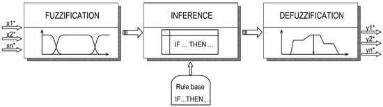
Figure 1.
Fuzzy inference diagram.
The application of fuzzy logic to the risk of damage to underground pipes and cables is a new problem. The starting point for the model is to determine the risk factors. Based on previous works by the author and other experts [36], the risk (RU) is assumed to be multivariate, which means it is
where ID is incomplete underground utility data;
HA is horizontal utility positioning accuracy;
VA is vertical utility positioning accuracy.
In this case, incomplete underground utility data means the absence of underground utilities in the spatial dataset even though they exist in situ. Horizontal and vertical positioning accuracy indicates how close underground utilities are to their actual positions in situ in the X, Y plane and Z plane, respectively.
Each of the three risk factors is described with a linguistic variable and has linguistic values assigned. Each variable was assigned one of three linguistic values: low, medium, and high. Values corresponding to the linguistic variables were defined with fuzzy sets described with characteristic functions. Membership functions were modelled with expert judgement. The author employed expertise and experience of contractors specialising in linear structures (water systems, sewers, power lines, or gas lines). Values of the linguistic variables were estimated from an analysis of 50 questionnaires completed by construction site managers (Table 3). All the construction works investigated here were in urbanised areas. In these circumstances, building plans and specifications are usually based on a 1:500 large-scale map.
Table 3.
Values of linguistic variables for risk factors.
The membership functions were modelled on the basis of a structured elicitation of practitioner–experts’ opinions. The experts were site managers/works managers carrying out linear projects in urbanised environments. The selection of experts was purposive to ensure direct and up-to-date experience in planning and executing works in the vicinity of underground utilities. The task context reflects the standard practice of using 1:500 maps and data from official databases. Opinions were collected via a questionnaire (N = 50) in which three risk factors (ID, HA, VA) were defined and respondents were asked to indicate transition thresholds between the low, medium, and high classes (in %). The collected responses were aggregated to determine the a, b, c, d points of trapezoidal functions for each factor. During aggregation, the partition-of-unity and continuity conditions were enforced, and extreme values were smoothed to avoid non-physical transitions. The resulting value distributions are presented in Table 4. This procedure ensures transparency and reproducibility in constructing the membership functions while maintaining consistency with construction practice.
Table 4.
Distribution of values of membership functions.
Methods—From expert judgement to model parameters:
- Elicitation and sample. We conducted a structured questionnaire among practitioner–experts (site/works managers involved in linear projects near underground utilities) working in urbanised areas where 1:500 base maps and official databases are standard. N = 50 completed questionnaires. Each respondent was asked to indicate threshold values (in %) that separate low/medium/high classes for three risk factors: incompleteness of underground utility data (ID), horizontal accuracy (HA), and vertical accuracy (VA).
- Aggregation to objective parameters. Individual thresholds were aggregated to determine the four breakpoints (a, b, c, d) of trapezoidal membership functions for each factor. During aggregation, we enforced two mathematical conditions that guarantee internal consistency of the scales: partition of unity and continuity across adjacent classes; extreme outliers were smoothed to avoid non-physical transitions. The resulting distributions and parameters are reported in Table 3 and Table 4 and by closed-form formulas for u(ID), u(HA), and u(VA). Trapezoids were selected because experts provided interval cores of full membership, which this shape naturally captures.
- Rule base from expert knowledge. Expert reasoning was encoded as 27 intuitive IF–THEN rules in a Mamdani controller. Inference uses Zadeh min–max composition with standard t-norm/s-norm operators; this turns linguistic premises into fuzzy consequences in a reproducible way. The full rule base (Table 6) and operators are specified in the manuscript.
- From fuzzy to crisp indicators. Given any triplet (ID, HA, VA), fuzzification yields degrees of membership (example shown in Table 5), the rule base computes the output membership (Figure 9), and centre-of-gravity defuzzification produces a single numeric risk R ∈ [0, 1], which we map to low/medium/high classes. Worked examples for urban, suburban, and rural settings are reported (e.g., R = 0.33/0.55/0.86 for illustrative inputs). This pipeline makes the translation from subjective inputs to an objective, repeatable indicator explicit.
Table 5. Membership values for the input variables.
Bias and representativeness safeguards:
- We mitigated individual–expert idiosyncrasies by aggregating across N = 50 practitioners and by constraining the aggregated scales with partition-of-unity and continuity, which prevents any single respondent from dominating the class boundaries.
- The explicit publication of (a, b, c, d) parameters, rule base, and operators enables independent replication or recalibration with another expert panel, turning subjective inputs into auditable model components.
Limitations:
The expert panel comprises site/works managers from urbanised contexts, therefore, the elicited thresholds chiefly reflect urban practice; while we demonstrate the model on suburban and rural input scenarios and note that membership function locations can be shifted to reflect other data quality classes, full representativeness for non-urban settings requires re-elicitation or calibration with experts active in those environments.
The distribution of values of membership functions u(ID), u(HA), and u(VA) for respective fuzzy sets is shown in Table 3. The membership functions were defined guided by two primary conditions [40]:
- The functions should satisfy the condition of partition of unity. A point in a transition zone belonging to one area to degree p belongs to the neighbouring area to degree 1 – p.
- Membership functions u(x) should be continuous in the entire universe of discourse X.
To meet these conditions and ensure the maximum fit of the membership functions to characteristic points of the fuzzy sets (Table 4), the author employed a trapezoidal membership function (Table 2).
Trapezoidal functions were adopted because the expert elicitation produced intervals with a core of full membership, which are naturally modelled by the trapezoid’s “plateau.” Continuity and partition of unity across the classes (L–M–H) were ensured, and the function parameters (breakpoints) correspond to the agreed data quality thresholds (Table 3 and Table 4). Gaussian functions were not used due to their tails and lower interpretability under threshold-based data quality criteria.
The membership function for linguistic variable ‘incomplete underground utility data’ (ID) can be formalised as follows:
where ID_l, ID_m, ID_h are the low, medium, and high levels of incompleteness of underground utility data.
The fuzzy sets that describe function ID are presented in Figure 2.
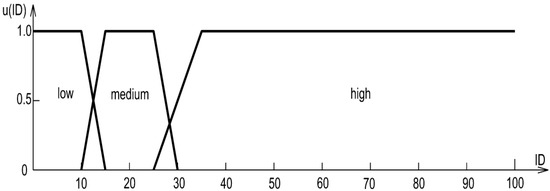
Figure 2.
The membership function for linguistic variable ‘incomplete underground utility data’ (ID).
The membership function for linguistic variable ‘horizontal accuracy’ (HA) can be formalised as follows:
where HA_l, HA_m, HA_h are low, medium, and high levels of horizontal accuracy.
The fuzzy sets that describe function HA are presented in Figure 3.
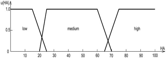
Figure 3.
The membership function for linguistic variable ‘horizontal accuracy’ (HA).
The membership function for linguistic variable ‘vertical accuracy’ (VA) can be formalised as follows:
where VA_l, VA_m, VA_h are low, medium, and high levels of vertical accuracy.
The fuzzy sets that describe function VA are presented in Figure 4.

Figure 4.
The membership function for linguistic variable ‘vertical accuracy’ (VA).
The risk of damage to underground pipes and cables is defined as a triplet described with linguistic variables: low, medium, and high risk.
The membership function for linguistic variable ‘risk’ (R) can be formalised as follows:
where R_l, R_m, R_h are low, medium, and high risk, respectively.
The range of linguistic variables is based on risk analysis factors for the construction industry [41]. The membership function is shown in Figure 5.
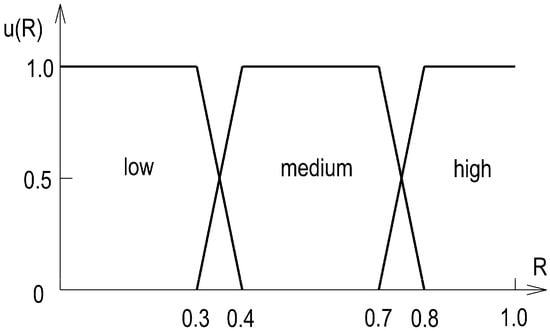
Figure 5.
The membership function for linguistic variable ‘risk’ (R).
3. Results and Discussion
The completeness of underground utility data in this model is 89.0%. Horizontal accuracy, which is essential to construction projects is ensured at 69.0%. The required horizontal accuracy for the investigated risk is guaranteed by spatial data from land surveys and cartometric measurements on an analogue 1:500 map. The vertical accuracy required for construction works is ensured at 50.0%.
The first stage of fuzzy inference is fuzzification [40]. It involves the calculation of how much the input values belong to fuzzy sets. In this case, the crisp values of input variables for the three risk factors (incomplete underground utility data, horizontal accuracy, and vertical accuracy) are ID = 11.0; HA = 69.0; VA = 50.0. The calculations yielded the following degrees of membership for input variables ID (Figure 6), HA (Figure 7), and VA (Figure 8).
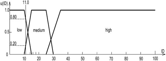
Figure 6.
Membership values of variable ‘incomplete underground utility data’.
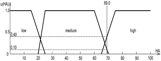
Figure 7.
Membership values of variable ‘horizontal accuracy’.
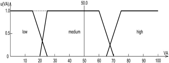
Figure 8.
Membership values of variable ‘vertical accuracy’.
The resulting degrees of membership of the input variables are shown in Table 5.
Fuzzy risk assessment requires a rule (knowledge) base. The rule base is paramount for the construction of the inference engine. Rules in the base substantially affect the results. The other components of the model, such as logical operators and the defuzzification method, have a minuscule impact [39].
The ‘if-then’ type of rule is intuitive and easy to interpret and use. This rule was used in the Mamdani fuzzy controller [40], for generating expert-judgement-based rule bases. For example, for a two-input model, the rules are
where x1, x2, y are the linguistic variables, A1, A2, C are the fuzzy sets characterising specific values of linguistic variables x1, x2, y.
The risk model in this article has a rule base with 27 expert-judgement rules (Table 6).
Table 6.
Rule base for multivariate risk of underground utility damage.
The rules in the base are used to calculate the degree of membership of risk factors ID, HA, and VA to the fuzzy sets representing the values of linguistic variables. Four rules are used in this case (5, 7, 9, and 13 in Table 6)
If ((ID = L) and (HA = M) and (VA = M)) then (R = M)
If ((ID = L) and (HA = H) and (VA = M)) then (R = L)
If ((ID = M) and (HA = M) and (VA = M)) then (R = M)
If ((ID = M) and (HA = H) and (VA = M)) then (R = M)
The fuzzy inference engine is based on rules with logical operations on fuzzy sets. The author uses intersection and union operations with triangular norms (t-norms and s-norms). The study employs Zadeh’s min–max composition, min-product, and max-union [37]. The product of fuzzy sets A and B is fuzzy set A∩B, defined by membership function:
The union of fuzzy sets A and B is fuzzy set A∪B, defined by membership function:
The minimum of the degree of membership of individual consequents of a rule was calculated with the MIN operator:
The values of the linguistic variables on the left side of Equation (20) concern risk factors. The right side of the equations are the resulting fuzzy sets of the risk.
The fuzzy result of the inference process was determined with the MAX operator:
The inference result, the calculated risk of damage to underground utilities, belongs to two sets (Figure 9): ‘low risk’ to degree 0.40 and ‘medium risk’ to degree 0.20.
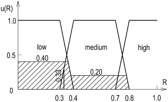
Figure 9.
Risk of damage to underground utilities.
Finally, the values of fuzzy inference were converted into crisp values. The literature offers many defuzzification methods yielding various numeric values. Fuzzy project risk analyses most often employ the centre of gravity method [38]. It is not a challenge to determine the coordinates of the centre of gravity of a surface with today’s computational techniques.
Defuzzification (COG method) yielded risk value R = 0.33 for this risk mode. This risk belongs to the ‘low risk’ set (Figure 9). The inference above concerns a specific underground utility damage risk model. The model is typical of spatial databases designed mainly for urban areas. The estimated risk of damage to underground utilities during construction works is low for these areas (Table 7).
Table 7.
The range of risk of underground utility damage.
Urban case values (completeness = 89%, HA = 69%, VA = 50%) correspond to the crisp inputs ID = 11, HA = 69, VA = 50 used in the worked example. They are scenario inputs anchored in local mapping practice (1:500 base map, land surveys/cartometric checks) and expert elicitation, not a project-specific audit. That the suburban and rural values (ID/HA/VA = 22/58/40 and 30/50/30) were assumed to illustrate different data quality classes. These inputs are consistent with the expert-derived thresholds that shaped the trapezoidal membership functions (Table 3 and Table 4).
Calculations of the risk of damage to underground utilities were also performed for suburban and rural areas. For suburban areas, the following numerical values of the risk factors were assumed: ID = 22.0, HA = 58.0, and VA = 40.0. In this case, the resulting risk value was R = 0.55. The computed risk belongs to the “medium risk” set (Table 7). For rural areas, the following numerical values of the risk factors were assumed: ID = 30.0, HA = 50.0, and VA = 30.0. In this case, the resulting risk value was R = 0.86. The computed risk belongs to the “high risk” set (Table 7).
The trend in our validation examples (Table 7) follows from the specific inputs chosen to represent “typical” datasets (urban: ID = 11, HA = 69, VA = 50 → R = 0.33; suburban: 22/58/40 → R = 0.55; rural: 30/50/30 → R = 0.86). This is not a tautology: the rule base and membership functions make (R) a function of data completeness and positional accuracy, not of the area label. For instance, rules such as (ID = Low, HA = High, VA = High ⇒ R = Low) show that a well-surveyed rural corridor can yield low (R); conversely, incomplete or misaligned urban data can produce high (R). The manuscript explicitly allows re-shaping/shift in membership functions to reflect other classes or local standards, reinforcing that (R) is data-driven rather than context-label driven.
3.1. Sensitivity of Membership Thresholds
Following the construction of the membership functions described in the paper (trapezoids with continuity and partition of unity, parameterized by points a–b–c–d in Table 4), we performed a one-at-a-time analysis. For each factor (ID, HA, VA), we scaled its membership thresholds by ±10% (simultaneously for all four points a–d of that factor), maintaining continuity and the sum-to-one condition across the L–M–H classes. We then re-ran Mamdani inference and centroid (COG) defuzzification for the three baseline scenarios used in the paper (urban, suburban, rural; see input values and results in Table 7).
In the urban scenario (ID = 11, HA = 69, VA = 50), R increased from 0.33 to 0.55 (+68%) after raising HA thresholds by 10%, while lowering HA thresholds by 10% yielded R = 0.269 (−18%). For ID, the changes were R = 0.274 (−16%) and R = 0.390 (+19%), respectively; VA had no effect (input in the M core). In the suburban scenario, R remained 0.55 for all perturbations, whereas in the rural scenario, shifting ID thresholds by +10% reduced R from 0.86 to 0.607 (−29.6%), and −10% raised R to 0.870 (+0.9%). Sensitivity is greatest near class boundaries, while results are stable within class cores (Table 8).
Table 8.
Sensitivity of membership thresholds.
3.2. Methodological Recommendations and Reduction in Epistemic Uncertainty
Methodological recommendations and reduction in epistemic uncertainty which includes the following ready-to-implement measures:
- Standardised expert elicitation—a brief calibration training, a shared glossary, reporting of thresholds (a, b, c, d) with confidence intervals and an agreement protocol. (In our case, elicitation already underpins the parameterization of membership functions; we are now clarifying the reporting and archiving procedure.)
- Sensitivity analysis of membership functions—systematic variation in breakpoints (a, b, c, d) and observation of the impact on R; identification of stable and unstable ranges.
- Validation of the rule base—consistency/monotonicity tests and a “leave-one-scenario-out” procedure on available cases (urban/suburban/rural) with reporting of activated rules.
- Triangulation of data sources—combining GIS databases with field observation and non-invasive surveys (e.g., scanning/test trenches in line with the quality thresholds: ID, HA, VA). We added triggers for field verification: ID > 25% or HA/VA > 65% → mandatory in situ verification.
- Model updating and versioning—maintaining versioned parameters (membership functions, rules), a change log, and a “rolling update” mechanism after each project iteration.
- Limits of applicability and method selection—a decision matrix: FIS is recommended when epistemic uncertainty dominates and data are scarce (ID incompleteness, lack of failure statistics); PRA or hybrid models are preferred when stable quantitative time series are available. We supplemented the Conclusions with this explicit directive.
- Feedback from implementation—recording damage incidents and “as-built” data for cyclical recalibration of membership functions and rule revision.
3.3. Applications/Practical Guidance
What practitioners do with (R):
Our model delivers a crisp risk indicator R ∈ (0; 1] (with fuzzy classes low/medium/high defined by the membership functions shown in the paper). It is designed to (a) generate large-scale risk maps that highlight where data quality most threatens underground assets; and (b) drive concrete decisions on where to upgrade surveys, verify positions, or adjust construction methods.
- Network-wide planning (owners and cities): Use (R) maps to prioritise corridors/segments for data improvement and target budgets to locations where risk from data quality is highest. (“It will be employed to generate large-scale risk maps.”)
- Design and clash management (designers): Focus desktop reviews and clash checks on high-(R) segments; defer low-(R) segments to routine QA/QC.
- Construction means and methods (contractors): Tie potholing/vacuum excavation and utility locating intensity to (R): more intensive where (R) is high, standard practice where (R) is low/medium.
- Permitting and governance (authorities): Use (R) thresholds to set evidence requirements in permits (e.g., require verification before excavation in high-(R) zones).
- Continuous improvement: After works, ingest as-built/pothole logs to recalibrate membership breakpoints for the next programme cycle. (The paper notes that membership function distributions can be shifted for other data quality classes).
Actionable thresholds (decision guidance):
Consistent with the fuzzy sets for risk (R) provided in the manuscript (low dominant below ≈ 0.4, medium dominant ≈ 0.4–0.7, high dominant above ≈ 0.8, we propose the following norms:
- R ≲ 0.4 (Low): Proceed with standard controls; no mandatory verification beyond routine QA/QC.
- 0.4 ≲ R ≲ 0.7 (Medium): Targeted upgrades: additional locating in conflict areas/crossings; selective verification where design clearances are tight.
- R ≳ 0.8 (High): Mandatory verification (e.g., test pits/utility exposure) before excavation and/or design changes to increase clearances.
4. Conclusions
The risk of damage to buried pipes and cables is inherent to the construction process. One of the sources of this risk is the quality of spatial data. The literature enumerates three main causes of underground pipe and cable damage linked to spatial data quality. The first cause is the presence of underground utilities not recorded in a spatial database on a project site. This source of risk is referred to as incomplete spatial dataset. The second and third reasons concern the accuracy of horizontal and vertical positioning of buried pipes and cables in spatial databases, respectively.
The proposed method can estimate the risk of damage to underground pipes and cables for other data quality classes, such as data for rural areas. The distribution of the values of membership functions can be shifted in the model to assess the impact of diverse factors on the risk level.
In summary, this validation successfully demonstrates that the proposed fuzzy logic model is a highly effective and appropriate tool for assessing the risk of installation damage arising from the quality of spatial data. It should not be regarded as a universal substitute for PRA (Probabilistic Risk Assessment) but as a complementary methodology that is especially well-suited to risk assessment in data-poor environments characterised by epistemic uncertainty and reliance on qualitative expert judgement. The fuzzy model provides a robust, transparent, and interpretable framework for capturing the nuanced, non-linear reasoning of experts—reasoning that traditional linear models may oversimplify, potentially leading to an underestimation of risk in complex scenarios.
4.1. Integration with Spatial Databases and the Digital Twin
The proposed fuzzy system (Mamdani) with three inputs—ID (data incompleteness), HA (horizontal accuracy), VA (vertical accuracy)—and the output R (risk score, together with the RL/RM/RH class after defuzzification using COG) can be embedded directly in spatial data infrastructures and “digital twin” environments for construction monitoring. In practice, we map the model inputs to attributes of utility-network feature classes (e.g., completeness_pct = ID, h_pos_error_pct = HA, v_pos_error_pct = VA) and the outputs to fields risk_score (0–1), risk_class (RL/RM/RH), rule_version, and computed_at. FIS computations can be implemented along two equivalent paths: (i) an in-database stored function/UDF (e.g., invoked by a trigger after geometry/attribute edits) that updates the result for changed records; or (ii) a lightweight microservice (e.g., a Python script run periodically or driven by an event queue/CDC) that fetches changes, runs the FIS, and writes results back to the tables. This enables publishing risk heat maps and threshold-based alerts in the web-map portal (e.g., R > 0.7 → vacuum/verification potholing required before digging with an excavator), as well as roll-up reports for the owner and contractor.
In the constructionsite digital twin (BIM/IFC/CityGML), the value R becomes a property of the object instance (pipe segment, node, conflict crossing) and feeds planning logic: route prioritisation, method-of-excavation decisions, and sequencing of works in the schedule. Feedback loops—as-built surveys, GPR results, CCTV inspections—automatically adjust HA/VA/ID, which triggers risk re-evaluation and twin updates in near real time. For transparency and auditability we also store the membership degrees and the rule-base version identifier. Because the rule base is compact (27 rules) and the operations are min–max and COG, the computations are lightweight—suitable for incremental execution after each data change as well as batch processing to produce city-wide risk maps. This integration enables continuous, user-interpretable oversight of utility-conflict risk and supports “permit-to-dig” decisions within a common data environment.
4.2. Future Work
In this study, we developed a fuzzy risk model for damage to underground utilities based on three factors (ID, HA, VA), with trapezoidal membership functions and a 27-rule Mamdani inference base; the output was defuzzified using the centroid method and illustrated for urban, suburban, and rural scenarios. Future research will perform the following:
- Carry out external validation and calibration of the model on empirical data (records of actual strikes, as-built surveys), together with global sensitivity and uncertainty analyses of the membership functions and rules.
- Expand the factor space to include network density, depth and type of conduits, map/source class, age and reliability of records, detection method (e.g., GPR), and geotechnical–environmental conditions.
- Compare alternative inference frameworks (Mamdani vs. Sugeno), t-norm/s-norm operators and defuzzification methods, and explore type-2 fuzzy and hybrid fuzzy–PRA (Probabilistic Risk Assessment)/Bayesian models to better capture epistemic uncertainty.
- Learn parameters and reduce the rule base using ANFIS (Adaptive Neuro-Fuzzy Inference System) and evolutionary algorithms to improve transferability and limit expert bias.
- Integrate with 3D GIS/BIM (IFC/CityGML) for continuous city-/region-scale risk mapping and near-real-time “permit-to-dig” decision support.
- Link risk ratings to cost, schedule, and occupational health and safety (OHS) consequences and to cost–benefit analyses of additional surveying.
- Assess model transferability across jurisdictions and data quality classes (e.g., national utility registers) and develop implementation guidance for authorities and contractors.
Author Contributions
Conceptualization, M.Ś.; methodology, M.Ś.; software, M.Ś.; validation, A.P.; formal analysis, A.P.; investigation, A.P.; resources, M.Ś.; data curation, M.Ś.; writing—original draft preparation, A.P.; writing—review and editing, M.Ś.; visualization, A.P.; supervision, M.Ś.; project administration, A.P. All authors have read and agreed to the published version of the manuscript.
Funding
This research received no external funding.
Institutional Review Board Statement
Not applicable.
Informed Consent Statement
Not applicable.
Data Availability Statement
The original contributions presented in the study are included in the article, further inquiries can be directed to the corresponding author.
Conflicts of Interest
The authors declare no conflicts of interest.
References
- Gleim, I.N. CIA Review—Part I—The Internal Audit Activity’s Role in Governance, Risk and Control, Certified Internal Auditor; Gleim Publications Inc.: Gainesville, FL, USA, 2004. [Google Scholar]
- Kaplan, S.; Garrick, B.J. On the quantitative definition of risk. Risk Anal. 1981, 1, 11–27. [Google Scholar] [CrossRef]
- Fayaz, M.; Ahmad, S.; Ullah, I.; Kim, D. A Blended Risk Index Modeling and Visualization Based on Hierarchical Fuzzy Logic for Water Supply Pipelines Assessment and Management. Processes 2018, 6, 61. [Google Scholar] [CrossRef]
- Fayaz, M.; Ahmad, S.; Hang, L.; Kim, D. Water Supply Pipeline Risk Index Assessment Based on Cohesive Hierarchical Fuzzy Inference System. Processes 2019, 7, 182. [Google Scholar] [CrossRef]
- Fayaz, M.; Ullah, I.; Park, D.-H.; Kim, K.; Kim, D. An Integrated Risk Index Model Based on Hierarchical Fuzzy Logic for Underground Risk Assessment. Appl. Sci. 2017, 7, 1037. [Google Scholar] [CrossRef]
- Malinowska, A.; Cui, X.; Salmi, E.F.; Hejmanowski, R. A novel fuzzy approach to gas pipeline risk assessment under influence of ground movement. Int. J. Coal Sci. Technol. 2022, 9, 47. [Google Scholar] [CrossRef]
- Fayaz, M.; Pham, Q.B.; Linh, N.T.T.; Nhi, P.T.T.; Khoi, D.N.; Qureshi, M.S.; Shah, A.S.; Khalid, S. A Water Supply Pipeline Risk Analysis Methodology Based on DIY and Hierarchical Fuzzy Inference. Symmetry 2020, 12, 44. [Google Scholar] [CrossRef]
- Zhang, P.; Qin, G.; Wang, Y. Risk Assessment System for Oil and Gas Pipelines Laid in One Ditch Based on Quantitative Risk Analysis. Energies 2019, 12, 981. [Google Scholar] [CrossRef]
- Fu, X.; Gu, C.-S.; Su, H.-Z.; Qin, X.-N. Risk Analysis of Earth-Rock Dam Failures Based on Fuzzy Event Tree Method. Int. J. Environ. Res. Public Health 2018, 15, 886. [Google Scholar] [CrossRef]
- Zhang, H.; Li, Z.; Li, W.; Song, Z.; Ge, W.; Han, R.; Wang, T. Risk Analysis of Instability Failure of Earth–Rock Dams Based on the Fuzzy Set Theory. Water 2021, 13, 3088. [Google Scholar] [CrossRef]
- Topal, S.; Atasoylu, E. A Fuzzy Risk Assessment Model for Small Scale Construction Work. Sustainability 2022, 14, 4442. [Google Scholar] [CrossRef]
- Zhang, W.; Huang, Z.; Zhang, J.; Zhang, R.; Ma, S. Multifactor Uncertainty Analysis of Construction Risk for Deep Foundation Pits. Appl. Sci. 2022, 12, 8122. [Google Scholar] [CrossRef]
- Jin, H.; Goodrum, P.M. Optimal Fall Protection System Selection Using a Fuzzy Multi-Criteria Decision-Making Approach for Construction Sites. Appl. Sci. 2021, 11, 5296. [Google Scholar] [CrossRef]
- Jiang, W.; Zhang, Z.; Deng, X. A Novel Failure Mode and Effects Analysis Method Based on Fuzzy Evidential Reasoning Rules. IEEE Access 2019, 7, 113605–113615. [Google Scholar] [CrossRef]
- Heidary Dahooie, J.; Vanaki, A.S.; Firoozfar, H.R.; Zavadskas, E.K.; Čereška, A. An Extension of the Failure Mode and Effect Analysis with Hesitant Fuzzy Sets to Assess the Occupational Hazards in the Construction Industry. Int. J. Environ. Res. Public Health 2020, 17, 1442. [Google Scholar] [CrossRef]
- Biswas, T.K.; Zaman, K. A Fuzzy-Based Risk Assessment Methodology for Construction Projects Under Epistemic Uncertainty. Int. J. Fuzzy Syst. 2019, 21, 1221–1240. [Google Scholar] [CrossRef]
- Shi, B.; Zeng, T.; Tang, C.; Zhang, L.; Xie, Z.; Lv, G.; Wu, Q. Landslide Risk Assessment Using Granular Fuzzy Rule-Based Modeling: A Case Study on Earthquake-Triggered Landslides. IEEE Access 2021, 9, 135790–135802. [Google Scholar] [CrossRef]
- Cárdenas, G.J.R.; Nebot, À.; Mugica, F. Integral Seismic Risk Assessment through Fuzzy Models. Appl. Sci. 2020, 10, 3017. [Google Scholar] [CrossRef]
- Bianchini, S.; Solari, L.; Del Soldato, M.; Raspini, F.; Montalti, R.; Ciampalini, A.; Casagli, N. Ground Subsidence Susceptibility (GSS) Mapping in Grosseto Plain (Tuscany, Italy) Based on Satellite InSAR Data Using Frequency Ratio and Fuzzy Logic. Remote Sens. 2019, 11, 2015. [Google Scholar] [CrossRef]
- Uzhga-Rebrov, O.; Grabusts, P. Methodology for Environmental Risk Analysis Based on Intuitionistic Fuzzy Values. Risks 2023, 11, 88. [Google Scholar] [CrossRef]
- Gul, M.; Guneri, A.F.; Nasirli, S.M. A fuzzy-based model for risk assessment of routes in oil transportation. Int. J. Environ. Sci. Technol. 2019, 16, 4671–4686. [Google Scholar] [CrossRef]
- Zhou, H.; Yue, X.; Chen, Y.; Liu, Y.; Gong, G. Comprehensive Environmental and Health Risk Assessment of Soil Heavy Metal(loid)s Considering Uncertainties: The Case of a Typical Metal Mining Area in Daye City, China. Minerals 2023, 13, 1389. [Google Scholar] [CrossRef]
- Lisboa, É.G.; Mendes, R.L.R.; Figueiredo, M.M.P.; Bello, L.A.L. Fuzzy-Probabilistic Model for a Risk Assessment of Groundwater Contamination: Application to an Urban Zone in the City of Belém, Pará, Brazil. Water 2020, 12, 1437. [Google Scholar] [CrossRef]
- Ramirez, R.; Martí, V.; Darbra, R.M. Environmental Risk Assessment of Silver Nanoparticles in Aquatic Ecosystems Using Fuzzy Logic. Water 2022, 14, 1885. [Google Scholar] [CrossRef]
- Chen, X.; Li, F.; Zhang, J.; Liu, S.; Ou, C.; Yan, J.; Sun, T. Status, fuzzy integrated risk assessment, and hierarchical risk management of soil heavy metals across China: A systematic review. Sci. Total. Environ. 2021, 785, 147180. [Google Scholar] [CrossRef]
- Wijitkosum, S.; Sriburi, T. Fuzzy AHP Integrated with GIS Analyses for Drought Risk Assessment: A Case Study from Upper Phetchaburi River Basin, Thailand. Water 2019, 11, 939. [Google Scholar] [CrossRef]
- Li, Y.; Liu, Y.; Liu, X.; Shen, C. A Multiple Model Approach for Flood Forecasting, Simulation, and Evaluation Coupling in Zhouqu County. Water 2023, 15, 4246. [Google Scholar] [CrossRef]
- Noori, A.; Bonakdari, H.; Morovati, K.; Gharabaghi, B. Development of optimal water supply plan using integratedfuzzy Delphi and fuzzy ELECTRE III methods—Case study of the Gamasiab basin. Expert Syst. 2020, 37, e12568. [Google Scholar] [CrossRef]
- Chen, H.; Xu, Z.; Liu, Y.; Huang, Y.; Yang, F. Urban Flood Risk Assessment Based on Dynamic Population Distribution and Fuzzy Comprehensive Evaluation. Int. J. Environ. Res. Public Health 2022, 19, 16406. [Google Scholar] [CrossRef] [PubMed]
- Msabi, M.M.; Makonyo, M. Flood susceptibility mapping using GIS and multi-criteria decision analysis: A case of Dodoma region, central Tanzania. Remote. Sens. Appl. Soc. Environ. 2021, 21, 100445. [Google Scholar] [CrossRef]
- Noori, A.; Bonakdari, H. A GIS-Based Fuzzy Hierarchical Modeling for Flood Susceptibility Mapping: A Case Study in Ontario, Eastern Canada. Environ. Sci. Proc. 2023, 25, 62. [Google Scholar] [CrossRef]
- Wang, G.; Liu, Y.; Hu, Z.; Lyu, Y.; Zhang, G.; Liu, J.; Liu, Y.; Gu, Y.; Huang, X.; Zheng, H.; et al. Flood Risk Assessment Based on Fuzzy Synthetic Evaluation Method in the Beijing-Tianjin-Hebei Metropolitan Area, China. Sustainability 2020, 12, 1451. [Google Scholar] [CrossRef]
- Zhou, C.; Chen, M.; Chen, J.; Chen, Y.; Chen, W. A Multi-Hazard Risk Assessment Model for a Road Network Based on Neural Networks and Fuzzy Comprehensive Evaluation. Sustainability 2024, 16, 2429. [Google Scholar] [CrossRef]
- Rodríguez-Pérez, Á.M.; Rodríguez, C.A.; Márquez-Rodríguez, A.; Caparros Mancera, J.J. Viability Analysis of Tidal Turbine Installation Using Fuzzy Logic: Case Study and Design Considerations. Axioms 2023, 12, 778. [Google Scholar] [CrossRef]
- Rodríguez Pérez, Á.M.; Rodríguez, C.A.; Olmo Rodríguez, L.; Caparros Mancera, J.J. Revitalizing the Canal de Castilla: A Community Approach to Sustainable Hydropower Assessed through Fuzzy Logic. Appl. Sci. 2024, 14, 1828. [Google Scholar] [CrossRef]
- Oort, P. Spatial Data Quality: From Description to Application; Publications on Geodesy 60; Netherlands Geodetic Commission: Delft, The Netherlands, 2005; p. 140. [Google Scholar]
- Zadeh, L.A.; Aliev, R.A. Fuzzy Logic Theory and Applications: Part I and Part II; World Scientific Publishing Company: Singapore, 2018. [Google Scholar]
- Carter, J.; Chiclana, F.; Khuman, A.S. Fuzzy Logic: Recent Applications and Developments; Springer International Publishing: Berlin/Heidelberg, Germany, 2021. [Google Scholar]
- Ross, T.J. Fuzzy Logic with Engineering Applications; Wiley: Hoboken, NJ, USA, 2016. [Google Scholar]
- Piegat, A. Fuzzy Modeling and Control; Springer: Berlin/Heidelberg, Germany, 2014. [Google Scholar]
- Tchórzewska-Cieślak, B. Characterization of risk function in the analysis and assessment of water supply systems safety. Tech. Trans. 2018, 3, 187–196. [Google Scholar]

Disclaimer/Publisher’s Note: The statements, opinions and data contained in all publications are solely those of the individual author(s) and contributor(s) and not of MDPI and/or the editor(s). MDPI and/or the editor(s) disclaim responsibility for any injury to people or property resulting from any ideas, methods, instructions or products referred to in the content. |
© 2025 by the authors. Licensee MDPI, Basel, Switzerland. This article is an open access article distributed under the terms and conditions of the Creative Commons Attribution (CC BY) license (https://creativecommons.org/licenses/by/4.0/).