Abstract
This study aims to mitigate slope-collapse hazards that threaten life and property at the Lujiawan resettlement site in Wanbi Town, Dayao County, Yunnan Province, within the Guanyinyan hydropower reservoir. It integrates centimeter-level point-cloud data collected by a DJI Matrice 350 RTK equipped with a Zenmuse L2 airborne LiDAR (Light Detection And Ranging) sensor with detailed structural-joint survey data. First, qualitative structural interpretation is conducted with stereographic projection. Next, safety factors are quantified using the limit-equilibrium method, establishing a dual qualitative–quantitative diagnostic framework. This framework delineates six hazardous rock zones (WY1–WY6), dominated by toppling and free-fall failure modes, and evaluates their stability under combined rainfall infiltration, seismic loading, and ambient conditions. Subsequently, six-degree-of-freedom Monte Carlo simulations incorporating realistic three-dimensional terrain and block geometry are performed in RAMMS::ROCKFALL (Rapid Mass Movements Simulation—Rockfall). The resulting spatial patterns of rockfall velocity, kinetic energy, and rebound height elucidate their evolution coupled with slope height, surface morphology, and block shape. Results show peak velocities ranging from 20 to 42 m s−1 and maximum kinetic energies between 0.16 and 1.4 MJ. Most rockfall trajectories terminate within 0–80 m of the cliff base. All six identified hazardous rock masses pose varying levels of threat to residential structures at the slope foot, highlighting substantial spatial variability in hazard distribution. Drawing on the preceding diagnostic results and dynamic simulations, we recommend a three-tier “zonal defense with in situ energy dissipation” scheme: (i) install 500–2000 kJ flexible barriers along the crest and upper slope to rapidly attenuate rockfall energy; (ii) place guiding or deflection structures at mid-slope to steer blocks and dissipate momentum; and (iii) deploy high-capacity flexible nets combined with a catchment basin at the slope foot to intercept residual blocks. This staged arrangement maximizes energy attenuation and overall risk reduction. This study shows that integrating high-resolution 3D point clouds with rigid-body contact dynamics overcomes the spatial discontinuities of conventional surveys. The approach substantially improves the accuracy and efficiency of hazardous rock stability assessments and rockfall trajectory predictions, offering a quantifiable, reproducible mitigation framework for long slopes, large rock volumes, and densely fractured cliff faces.
1. Introduction
Yunnan lies within a transitional zone between the southeastern margin of the Qinghai–Tibet Plateau and the southern Yunnan–Guizhou Plateau. Shaped by multiple tectonic events and west-to-east descending terrain, the region is characterized by deeply incised gorges in the Hengduan Mountains, fault escarpments in central Yunnan, and karst cliffs in the east. These geological features collectively result in fractured rock masses highly prone to instability. Under gravitational loading or external triggers such as earthquakes and intense rainfall, unstable rock blocks may rapidly move via toppling, rolling, or free fall, resulting in typical rockfall hazards [,,]. These events are abrupt, short-lived, and difficult to predict. High-velocity rockfalls can cause severe damage to infrastructure such as roads and bridges. Their cascading impacts are often more destructive than those of landslides or debris flows [,]. In 2024, the Lujiawan resettlement site was impacted by a series of compound disasters, including debris flows and deformations triggered by rainfall. On 24 June, a debris flow carrying large boulders blocked the drainage culvert, resulting in a deposit of approximately 3500 m3. The event destroyed 30 m of steel pipe guardrails, damaged around 2 acres of farmland and 50 m of drinking water pipelines, and caused direct economic losses of approximately 300,000 yuan. On 5 September, intense rainfall triggered large-scale slope deformation, prompting the emergency relocation of two households. Therefore, developing a refined system for assessing rock mass stability and predicting three-dimensional rockfall trajectories has become a central task for disaster mitigation in Yunnan’s mountainous gorge regions. This system also provides essential technical support for the long-term safety management of transportation, energy, and urban infrastructure in mountainous areas. Rock slope stability is primarily governed by the orientation and configuration of structural planes. Stereographic projection methods allow intuitive identification of instability modes such as planar sliding, wedge sliding, and toppling failures [,], serving as effective tools for qualitative screening. Subsequently, the limit equilibrium method is used to calculate safety factors, enabling a coupled diagnostic approach that combines qualitative identification with quantitative analysis. In recent years, high-precision point cloud technologies—such as 3D laser scanning and UAV (unmanned aerial vehicle) photogrammetry—have developed rapidly, offering rich datasets for structural analysis. High-density point clouds enable detailed representation of rock surface geometries and joint distributions, greatly improving the efficiency of structural plane information extraction []. Intelligent structural plane recognition based on 3D laser scanning enables high-precision extraction of geometric features such as faults and fractures in rock slopes, offering critical parameters for quantitative stability assessment []. Early studies have confirmed its feasibility in steep rock slopes [], which has led to the development of various automated structural plane recognition algorithms. These algorithms have been integrated with discrete fracture network (DFN) models to quantitatively assess the stability of potential rock blocks []. Additionally, non-contact 3D scanning has been applied to monitor deformations of tunnel surrounding rocks and to measure structural planes, demonstrating strong adaptability in engineering practice []. The 3D point cloud technology enables high-resolution reconstruction of real-world environments, allowing safe and efficient acquisition of complete and accurate structural information for hazardous rock masses in complex terrains such as steep slopes. This provides reliable 3D model support for subsequent stability assessments []. Recent studies suggest that 3D laser scanning LiDAR has become an essential tool for high-precision modeling and stability assessment of hazardous rock masses. For example, solid-state LiDAR, when combined with detection algorithms, enables real-time identification of small-scale rockfalls in complex terrains []. In addition, airborne LiDAR integrated with multi-source imagery significantly improves the visualization and automated detection accuracy of landslide hazards in mountainous regions []. Jia Yue generated a high-resolution DEM from airborne LiDAR point clouds and integrated terrain shading with multisource imagery, significantly improving the visualization and automatic detection of landslide hazards in complex, vegetated terrain. This approach provides an efficient and reliable method for conducting large-scale landslide inventories [].
Accurate prediction of rockfall trajectories and impact zones depends on numerical simulations. Traditional two-dimensional numerical models, limited by geometric simplifications, can only simulate rockfall free-fall and rebound within a single cross-section. As a result, they fail to capture the three-dimensional dispersion and multiple impacts of rock blocks in complex terrain [,,]. Although models such as CRSP (Cluster-based Rockfall Susceptibility Prediction) and Rockyfor3D are widely used, the Swiss RAMMS::ROCKFALL model provides enhanced capabilities for simulating the full rockfall process—including jumping, rolling, and collision—on realistic 3D terrains. Compared to CRSP and Rockyfor3D, RAMMS::ROCKFALL incorporates a GPU-accelerated particle–rigid body coupled solver, unstructured meshes integrated with centimeter-resolution DEMs, and specialized models for collision fragmentation and energy dissipation in high-energy block impacts. It is well suited for high-precision simulations in complex environments such as canyon terrains, residential zones, and transportation infrastructure. Domestic researchers have used this model to perform three-dimensional kinematic analyses of earthquake-induced collapses, revealing energy distribution patterns [], and to derive bounce heights, velocities, and kinetic energies under real terrain conditions for delineating potential hazard zones []. However, a systematic integration of high-precision 3D mapping with dynamic simulation remains lacking—especially in parameter calibration and protective design for coupled scenarios involving mountainous residential zones and transportation routes.
To address this gap, the present study focused on the representative Lujiawan resettlement site. UAV (unmanned aerial vehicle)-derived point clouds, combined with stereographic projection methods, were first used to accurately identify structural planes and potential instability modes [,]. Then, three-dimensional dynamic simulations were performed using the RAMMS::ROCKFALL platform to quantitatively predict rockfall trajectories, kinetic energies, and accumulation patterns []. Building on existing technologies, this study developed a closed-loop quantitative workflow. First, high-resolution 3D laser scanning was conducted using centimeter-level UAV LiDAR (unmanned aerial vehicle-borne LiDAR) to reconstruct detailed geometric models of hazardous rock masses. Next, UAV imagery and field survey data were integrated to extract structural plane parameters such as joint orientations, and stereographic projection was applied to rapidly identify potential failure modes, including planar sliding, wedge sliding, and toppling. Based on this analysis, the limit equilibrium method was used to calculate safety factors for refined stability assessments. Finally, the evaluation results were imported into the RAMMS::ROCKFALL platform to conduct 3D dynamic simulations, generating key indicators such as rockfall trajectories, kinetic energies, bounce heights, and velocities. This workflow enables a systematic and repeatable framework for geometric reconstruction, structural analysis, and collapse risk prediction of hazardous rock masses. This system addresses traditional data acquisition blind spots on vertical cliffs and above residential areas, significantly improving the efficiency of rapid surveys for hazardous rocks on steep slopes. It provides reliable parameters to guide protective engineering measures, including the placement and strength of rockfall barriers. As a result, it offers scientific and dependable support for long-term safety management and disaster mitigation of transportation, energy, and urban infrastructure in Yunnan and similar mountainous gorge regions, demonstrating significant practical engineering value.
2. Materials and Methods
This section outlines the data sources, analytical methods, and simulation techniques used in this study. First, the geological and geomorphological characteristics of the study area are introduced. The methodology for rock mass stability assessment is then described. This is followed by a description of the theoretical framework and key parameters used to simulate rockfall trajectories after failure. Finally, simulation results are analyzed to assess potential hazards and support the development of mitigation strategies.
2.1. Study Area Overview
The study area is located at the Lujiawan resettlement site in Dayao County, Yunnan Province, within a tectonically incised mid-mountain belt along the Jinsha River. The terrain exhibits a southeast-to-northwest decline in relief, with a highly dissected landscape. Ridge lines predominantly trend north–south, aligning with regional master faults. The landform is characterized by deeply incised mid-mountain terrain, with a maximum relative relief of 901.92 m, resulting in the development of pronounced steep slopes. Data acquisition was based on the China Geodetic Coordinate System 2000 (CGCS2000) for planar coordinates, the 1985 National Elevation Datum, and the 3° Gauss–Krüger projection with a central meridian of 102° E. Terrain mapping was carried out using a DJI Matrice 350 RTK UAV equipped with a Zenmuse L2 airborne LiDAR sensor. The LiDAR sensor is equipped with multi-frequency scanning and dual-polarized antennas, achieving a ranging accuracy of 2 cm at a distance of 150 m and a maximum range of 500 m. Each laser pulse can record up to five returns, with a scanning field of view of ±30° in the vertical direction and ±45° in the horizontal direction, enabling vegetation penetration to accurately capture the ground surface. Flight paths were designed in a grid pattern, with a consistent flight altitude of 70 m above ground level. The flight lines were further refined to account for substantial elevation changes and steep terrain, ensuring full coverage of critical and potentially occluded areas. Figure 1 presents a panoramic view of the Lujiawan resettlement site.
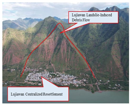
Figure 1.
Overview of the Lu jia wan Resettlement Site.
The site is located in a transitional zone where the first terrace of the Jinsha River merges with a debris-flow fan and colluvial deposits. The cross-section exhibits a break-line morphology, characterized by a southeast-facing cliff locally exceeding 70° in slope and rising over 500 m in height. In contrast, the northwest side consists of a gently inclined residential platform formed through artificial leveling. The area displays a compound hazard geomorphology, characterized by potential gravitational disasters—such as landslides, rockfalls, and debris flows—that are spatially complex and highly abrupt. The stratigraphy is primarily composed of Holocene debris-flow deposits (Q4set), alluvial–pluvial deposits (Q4al+pl), and colluvial deposits (Q4col) from the Quaternary, along with the Middle Jurassic Shedian Formation (J2s). The unconsolidated deposits consist of gravels, angular clasts, and weathered sandstone fragments, forming loose and heterogeneous masses that serve as the primary material basis for unstable accumulations. In contrast, the Shedian Formation—characterized by thick-bedded massive quartz sandstone with mudstone interbeds—provides a rigid structural framework that controls the development and configuration of hazardous rock masses. High-resolution terrain data acquired via airborne LiDAR are used to generate a realistic three-dimensional surface model (with a resolution of 0.05 m), which serves as the terrain input for RAMMS::ROCKFALL simulations. Based on engineering investigation results, the spatial distribution of hazardous rock masses is illustrated in Figure 2.
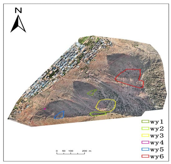
Figure 2.
Distribution of Hazardous Rock Masses.
In summary, the Lujiawan site integrates complex geomorphic structures, fragmented deposits, and multiple geological hazards, making it a representative location for the identification of unstable steep-slope rock masses and the analysis of rockfall dynamics.
2.2. Qualitative Assessment of Rockfall Hazards
The collapse zone exposes sandstone of the Middle Jurassic Shedian Formation (J2s), characterized by medium-thick to massive bedding. The rock is hard, with near-surface uniaxial compressive strength reaching 102.92 MPa. The bedding attitude is 70°/18°, while the slope aspect ranges from 298° to 330°, resulting in a reverse- to oblique-dip configuration that favors overall slope stability. Structural deformation and stress unloading have produced a well-developed system of bedding joints and fractures. The joint characteristics of the six hazardous rock masses are summarized in Table 1.

Table 1.
Characteristics of Joints and Fractures.
Based on the joint–fracture statistics of the six hazardous rock masses (Table 1), rose diagrams of the joint strike and dip were generated (Figure 3e,i). Although the strike orientations are complex, two dominant joint sets are distinguishable, trending approximately 0–70° and 310–350°, respectively. The dip-direction rose diagram identifies three prevalent joint sets: ① 220–260°/11–27°, ② 270–360°/64–80°, and ③ 270–290°/16–35°. Among them, the latter two sets are more prominently developed, while the first is relatively less pronounced. In addition to the identified structural sets, irregular weathering-induced fractures are also observed within the hazardous rock zone. Consequently, the collapse zone exposes hard rock characterized by abundant but poorly bonded discontinuities, resulting in a fractured-block structure. The degree of fragmentation classifies the rock mass as Rock Mass Quality Class IV, indicating that the slope is globally stable and unlikely to experience large-scale, whole-mass failure. However, the near-surface rock is highly fractured. On steep and protruding faces, joint-bounded blocks are locally unstable and prone to collapse under external forces.
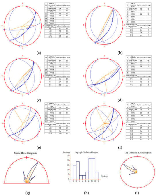
Figure 3.
Stereographic Projection Diagrams and Joint-Fracture Rose Diagrams: (a) WY1 Stereographic Projection Diagram; (b) WY2 Stereographic Projection Diagram; (c) WY3 Stereographic Projection Diagram; (d) WY4 Stereographic Projection Diagram; (e) WY5 Stereographic Projection Diagram; (f) WY6 Stereographic Projection Diagram; (g) Overall Joint-Fracture Strike Rose Diagram; (h) Dip Angle Distribution Histogram; (i) Overall Joint-Fracture Dip Direction Rose Diagram.
Stereographic projection maps three-dimensional inclined structures onto a two-dimensional spherical net and is widely used for analyzing the orientations of discontinuities. In rock slope engineering, it enables the identification of spatial relationships between joint sets and the slope face, thereby facilitating the assessment of potential wedge sliding failure modes []. By plotting great-circle poles, the method intuitively reveals potential sliding directions and failure risks, offering critical support for slope stability analysis and the design of reinforcement measures. The stereographic projection analysis provides the following stability interpretations for each hazardous rock mass:
Aggregated joint data from all six hazardous rock zones (WY1–WY6), as summarized in Table 1, were used to generate the rose diagrams shown in Figure 3g,i. Stratigraphic layer C exhibits a general dip direction of 70° and a dip angle of 18°.
(1) For WY1, the primary structural planes contributing to potential slope failure are joints ① and ②. The likely failure mode is wedge sliding along the intersection of joint ② and bedding plane C. Other structural planes, oriented opposite or oblique to the slope face, play a secondary role in the potential failure mechanism. Overall, the slope is assessed as marginally stable. The corresponding stereographic projection is shown in Figure 3a.
(2) For WY2, the primary structural planes contributing to potential slope failure are joint ② and bedding plane C. The likely failure mode is wedge sliding along the intersection of joint ② and bedding plane C. Other structural planes, oriented opposite or oblique to the slope face, play a secondary role in the failure mechanism. Overall, the slope is assessed as marginally stable. The corresponding stereographic projection is shown in Figure 3b.
(3) For WY3, the primary structural planes contributing to potential slope failure are joint ② and bedding plane C. The likely failure mode is wedge sliding along the intersection of joint ② and bedding plane C. Other structural planes, oriented opposite or oblique to the slope face, play a minor role in the failure mechanism. Overall, the slope is assessed as marginally stable. The corresponding stereographic projection is shown in Figure 3c.
(4) For WY4, the primary structural planes contributing to potential slope failure are joint ② and bedding plane C. The likely failure mode is wedge sliding along the intersection of joint ② and bedding plane C. Other structural planes, oriented opposite or oblique to the slope face, play a secondary role in the failure mechanism. Overall, the slope is assessed as marginally stable. The corresponding stereographic projection is shown in Figure 3d.
(5) For WY5, the primary structural planes contributing to potential slope failure are joint ① and bedding plane C. The likely failure mode is wedge sliding along the intersection of joint ① and bedding plane C. Other structural planes, oriented opposite or oblique to the slope face, play a minor role in the failure mechanism. Overall, the slope is assessed as marginally stable. The corresponding stereographic projection is shown in Figure 3e.
(6) For WY6, the primary structural planes contributing to potential slope failure include combinations of joints ① and ②, joints ② and ③, and joint ③ with bedding plane C. The likely failure modes are wedge sliding along the intersections of these joint combinations. Other structural planes, oriented opposite or oblique to the slope face, play a secondary role in the failure mechanism. Overall, the slope is assessed as marginally stable. The corresponding stereographic projection is shown in Figure 3f.
2.3. Quantitative Evaluation of Rockfall Hazards
(1) Stability Calculations of Hazardous Rock Masses
In the study area, the instability of hazardous rock masses primarily manifests in two failure modes: toppling and falling. Stability analysis was conducted under three distinct conditions: natural state, intense rainfall, and seismic loading. The computational models employed are as follows:
① Stability Analysis of Rockfall-Type Hazardous Rock Masses
Based on the spatial geometry and structural plane configuration of hazardous rock masses in the study area, the WY1 rock mass is primarily characterized by a rockfall-type failure mode.
(a) The parameter j is calculated using the following equation (Figure 4):
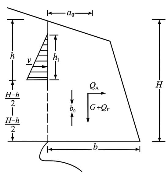
Figure 4.
Stability Analysis of Undercutting-Induced Falling Failure in Rockfall-Prone Areas.
In the equation, the variables are defined as follows:
denotes the factor of safety.
represents the self-weight of the hazardous rock mass (kN).
Qy represents the horizontal or external additional force, expressed in kilonewtons (kN).
denotes the cohesion of the hazardous rock, expressed in kilopascals (kPa).
represents the vertical distance from the upper end of the rear-edge fissure to the lower end of the unpenetrated section (i.e., the height of the hazardous rock cantilever), expressed in meters (m).
denotes the depth of the rear-edge fissure, expressed in meters (m).
(b) The stability of break-off and free-fall failure in rockfall-type hazardous rock masses is calculated using the following equation (Figure 5):
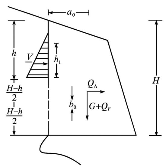
Figure 5.
Stability Analysis of Fracture-Induced Falling Failure in Rockfall-Prone Areas.
In the equation, the variables are defined as follows:
denotes the flexural (tensile-break) factor of safety for the hazardous rock mass.
represents the vertical surcharge acting on the rock mass (e.g., accumulated debris or vegetation), expressed in kilonewtons (kN).
represents the horizontal surcharge acting on the rock mass (e.g., wind or vibration forces), expressed in kilonewtons (kN).
is the vertical distance from the point of application of the sliding force to the fracture (break-off) point, expressed in meters (m).
denotes the sliding or shear force acting along the shear surface of the rock mass (e.g., seismic inertial force), expressed in kilonewtons (kN).
denote the horizontal and vertical distances, respectively, between the rock-mass centroid and the midpoint of the rear-edge vertical plane, expressed in meters (m).
represents the tensile strength of the rock mass, expressed in kilopascals (kPa).
② Stability Analysis of Toppling-Mode Hazardous Rock Masses
Based on the spatial geometry and structural plane configurations of hazardous rock masses in the study area, WY2, WY3, WY4, WY5, and WY6 are primarily characterized by toppling-type failure modes.
(a) When the centroid of the hazardous rock mass is located on the inner side of the midpoint of its base, the basal break-off toppling stability is calculated using the following equation (Figure 6):
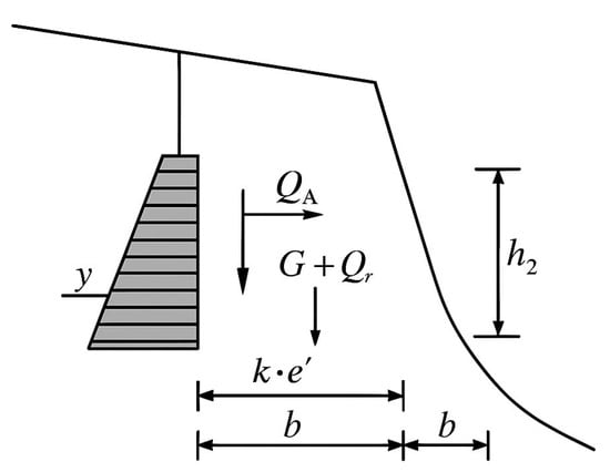
Figure 6.
Stability Analysis of Base Fracture-Induced Toppling Failure in Rockfall-Prone Areas.
(b) When the center of gravity of the hazardous rock mass extends beyond the midpoint of its base yet remains within the front edge, the toppling stability governed by rear-tension failure can be evaluated using the following equation:
In Equations (3) and (4), the variables are defined as follows:
and represent the safety factors for break-off toppling stability under two conditions: (i) the center of gravity is located within the midpoint of the base (), and (ii) it extends beyond the midpoint but remains within the front edge ().
denotes the sliding or shear force acting along the shear surface of the rock mass (e.g., seismic inertial force), expressed in kilonewtons (kN).
represents the vertical surcharge acting on the rock mass (e.g., accumulated debris or vegetation), expressed in kilonewtons (kN).
represents the horizontal surcharge acting on the rock mass (e.g., wind or vibration forces), expressed in kilonewtons (kN).
represents the width of the rock mass at the base (i.e., the width of the fracture section), in meters (m).
denotes the horizontal distance from the centroid of the rock block to the midpoint of its base (i.e., the eccentricity of the centroid), in meters (m).
denotes the vertical distance from the centroid of the block to the midpoint of its base (i.e., the centroid height), expressed in meters (m).
represents the vertical surcharge (e.g., accumulated debris, vegetation, or temporary loading), expressed in kilonewtons (kN).
denotes the lever arm height of the shear force V relative to the fracture point, expressed in meters (m).
When significant variation exists in the cross-sectional width of the rock block, segments exhibiting pronounced changes should be considered as potential basal surfaces for calculating the factor of safety. (c) When the centroid of the hazardous rock mass is located within the front edge of the pedestal’s top surface, the rear-tension break-off toppling stability is calculated using the following equation (Figure 7):
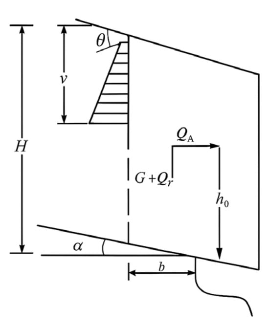
Figure 7.
Stability Analysis of Rear Tension-Induced Toppling Failure in Rockfall-Prone Areas.
In the equation, the variables are defined as follows:
denotes the factor of safety for rear-tension break-off toppling stability.
denotes the horizontal distance from the centroid of the rock mass to the front edge of the pedestal’s top surface, expressed in meters (m).
denotes the dip angle of the steeply inclined rear-edge structural plane, expressed in degrees (°).
represents the self-weight of the hazardous rock mass (kN).
represents the vertical surcharge acting on the rock mass (e.g., accumulated debris or vegetation), expressed in kilonewtons (kN).
represents the vertical distance from the upper end of the rear-edge fissure to the lower end of the unpenetrated section (i.e., the height of the hazardous rock cantilever), expressed in meters (m).
denotes the depth of the rear-edge fissure, expressed in meters (m).
denotes the vertical distance from the line of action of the horizontal seismic force to the front edge of the pedestal’s top surface, expressed in meters (m).
denotes the dip angle of the contact surface between the rock mass and the pedestal, expressed in degrees (°).
denotes the horizontal distance from the lower end of the extended rear-edge fracture to the front edge of the pedestal’s top surface (i.e., the horizontal projection of the contact length), expressed in meters (m).
denotes the horizontal thrust induced by external forces (e.g., wind or seismic loading), expressed in kilonewtons (kN).
denotes the resisting horizontal force acting opposite to the toppling direction (e.g., anchoring system counterforce), expressed in kilonewtons (kN).
denotes the vertical distance from the point of application of Qk to the base of the pedestal, expressed in meters (m).
denotes the vertical distance from the point of application of the shear force V to the rear-edge fracture point, expressed in meters (m).
σ represents the tensile strength (or unit tensile resistance) of the rear-edge fracture surface of the hazardous rock mass, expressed in kilopascals (kPa).
(2) Calculation Parameters for Hazardous Rock Masses
① Determination of Geotechnical Parameters
The physical and mechanical properties of the rock were determined by analogy and calibrated using laboratory test results. Structural plane parameters were primarily selected based on field-observed characteristics and the mechanical properties of infilling materials, with reference to empirical data from the Technical Code for Building Slope Engineering (GB 50330-2013) []. The mechanical parameters used in the stability analysis of hazardous rock masses are summarized in Table 2.

Table 2.
Rock Mechanical Properties in the Survey Area.
② Seismic Acceleration
According to the Seismic Ground Motion Parameter Zonation Map of China (GB 18306-2015) [], the seismic fortification intensity in the study area is Grade 7, corresponding to a design peak ground acceleration (PGA) of 0.15 g.
③ Geometric Parameters of Hazardous Rock Masses
The required lengths, dip angles, and areas were directly measured on the cross-sections used for the calculations.
(3) Results of Stability Calculations
Stability analyses and factor of safety calculations were conducted for six hazardous rock masses based on the mechanical models of toppling and falling failure modes, their corresponding stability equations, and the specified loading conditions, using the respective cross-sectional geometries of each mass. The results are summarized in Table 3.

Table 3.
Stability Analysis Results of Rockfall-Prone Areas.
2.4. Prediction of Rockfall Trajectories Induced by Rock Mass Instability
2.4.1. Theoretical Framework of the Rockfall Simulation Model
The RAMMS::ROCKFALL module was jointly developed by the Center for Mechanics at ETH Zurich and the Swiss Federal Institute for Forest, Snow, and Landscape Research (WSL). It is based on rigid-body Lagrangian mechanics and employs an explicit time integration scheme to solve the six-degree-of-freedom dynamic response of rock blocks on 3D terrain surfaces, accounting for both translational and rotational motions. A key feature of the model is its implementation of full 3D rigid-body dynamics, incorporating non-smooth contact mechanics and hard-contact laws to accurately simulate transitions among bouncing, rolling, and sliding. This allows for a realistic representation of energy dissipation and dynamic coupling throughout the rockfall process []. Compared to traditional simplified models, this module integrates contact algorithms and a scarring mechanism, allowing it to accommodate complex block geometries and soft ground conditions and to comprehensively simulate multiple motion modes including bouncing, rolling, and sliding []. The system supports both single-trajectory analysis and multi-trajectory statistical simulations and provides output parameters including bounce height, velocity, rotational energy, and total kinetic energy. It provides high-precision, three-dimensional dynamic simulation support for rockfall hazard assessment and the design of protective engineering measures.
During the free-flight phase, the motion of the rock block is governed by the following set of coupled dynamic equations:
Here, M is a constant, diagonal mass matrix that includes the total mass and the three principal moments of inertia (I). The vector u contains the three translational and three rotational velocity components of the rock block, while q denotes the generalized coordinates, including both the centroid position and orientation parameters. The motion of the rock block is governed by multiple forces that collectively determine its trajectory. The gravitational force Fg acts on the entire mass of the rock block. The resistance force (D) accounts for the effects of vegetation (e.g., trees and shrubs) and soil deformation. Additionally, the gyroscopic force (G) enables irregularly shaped rock blocks to maintain upright orientation and rotate around their rolling axis. In the RAMMS::ROCKFALL module, the rock–ground interaction is modeled using a non-smooth contact mechanics framework under hard-contact assumptions. The equations governing the motion of the rock block can be expressed as follows:
In the equation, M denotes the mass–inertia matrix.
u represents the velocity vector, comprising three translational and three rotational components.
h(q,u) denotes the combined external forces acting on the rock block, including gravity, resistance, and gyroscopic effects.
λ denotes the Lagrange multiplier associated with the contact force.
W(q) denotes the contact force direction matrix.
RAMMS::ROCKFALL employs a rigid-body non-smooth dynamics model to explicitly simulate the rockfall process under multiple contact interactions between the rock and the terrain surface. The model allows contact forces to act at locations other than the centroid and fully incorporates angular velocity and its direction to generate realistic torques that drive rotational and rebound motions. This enables accurate characterization of complex response mechanisms, including impact, sliding, and rolling, and represents a significant improvement over conventional models based solely on restitution coefficients. In modeling energy dissipation, RAMMS (Rapid Mass Movements Simulation) incorporates two resistance mechanisms: viscoplastic drag and velocity-dependent sliding resistance. These mechanisms respectively simulate viscoplastic deformation upon impact with soft surfaces and kinetic energy loss during sliding. The viscoplastic drag is integrated into the dynamic equations as a term proportional to the square of the sliding velocity, effectively capturing the absorption and dissipation of kinetic energy by ground materials. In the RAMMS module, this resistance is defined as a function of the squared sliding velocity and is expressed as follows:
In the equation, denotes the viscoplastic resistance force.
m denotes the mass of the rock block.
denotes the sliding velocity of the rock block along the terrain surface.
denotes the terrain resistance coefficient, which reflects the relative stiffness or softness of the surface material. This model indicates that heavier and faster-moving rock blocks undergo more intense deformation in weaker soil substrates, leading to greater energy dissipation.
RAMMS::ROCKFALL is based on rigid-body dynamics and hard-contact theory, enabling precise simulation of the complete rockfall process—including sliding, rolling, and bouncing—on three-dimensional terrain. It overcomes the limitations of traditional two-dimensional models in capturing block geometry, rotational motion, and complex terrain features. It supports both single-trajectory dynamic analysis and multi-trajectory statistical simulation and provides output parameters including bounce height, velocity, rotational energy, and total energy variation. This provides a physics-based, high-precision dynamic foundation for rockfall hazard assessment and the optimization of protective engineering measures.
2.4.2. Parameters for Rockfall Simulation
RAMMS::ROCKFALL can directly import measured 3D point clouds of rock blocks and convert their complex geometries into polyhedral rigid bodies, thereby preserving morphological and scale variability caused by geological heterogeneity within the numerical domain. Based on this input, the model performs stepwise integration of the 3D trajectories of falling rock blocks and outputs key dynamic indicators, including bounce height, translational and rotational velocities, total kinetic energy, and the impact force generated at each collision. By simultaneously incorporating actual block geometry and in-situ release kinematics, RAMMS::ROCKFALL realistically reproduces the complete rockfall process under site-specific geological conditions, providing reliable dynamic support for hazard zone assessment and the optimization of protective design. A density of 2700 kg/m3 (material strength parameters were determined from laboratory tests on samples collected in the field) is assigned to the six quartz sandstone blocks located in hazardous zones WY1–WY6. The terrain is modeled as a moderately hard debris slope sparsely covered with vegetation The ground equivalent elastic modulus is set to ME = 6 (MN/m2) (simulation parameters were derived from field investigation data and the RAMMS::ROCKFALL user manual; ME represents soil (terrain) parameters.), and the viscoplastic drag coefficient is set to Cd = 2.10 (model parameters were selected based on site-specific field conditions and the recommendations provided in the RAMMS::ROCKFALL user manual). The six source zones are treated as independent release surfaces, with an initial translational velocity of v0 = 0 (in all simulations, a zero initial release velocity was assumed) and an initial angular velocity ω0 randomly sampled from a uniform distribution between 0 and 0.2 rad/s (angular momentum parameters were set within the influence range recommended in the RAMMS::ROCKFALL user manual). A total of 600 trajectories were generated by assigning 10 randomly selected release points and 10 slope-parallel trajectory directions per hazardous rock zone. The simulation employs a contact time step of 0.02 s (simulation was conducted using the default setting as defined in the RAMMS::ROCKFALL User Manual) and outputs 3D trajectory clouds that illustrate the evolution of velocity, bounce height, and total kinetic energy as a function of travel distance.
3. Results
Based on numerical simulations of six hazardous rock masses (WY1–WY6; see Figure 8) and spatial profiles of kinetic energy, velocity, and bounce height for WY3 and WY6 (see Figure 9), the rockfall process exhibits a three-stage dynamic evolution: (1) an initial free-fall stage, characterized by gravity-driven acceleration and energy accumulation; (2) a transport–rebound stage, involving high-elasticity impacts between blocks and slope surfaces, where sliding, bouncing, and rolling are coupled, and kinetic and potential energy alternate cyclically, resulting in localized energy peaks; and (3) a deceleration–deposition stage, in which friction and contact damping gradually dissipate energy as the block enters a gentler slope zone, transitioning from bouncing and rolling to slow sliding until its velocity falls below a critical threshold and it comes to rest.
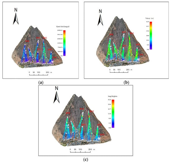
Figure 8.
Rockfall trajectory diagrams for all 600 simulated trajectories (100 per zone) aggregated across WY1–WY6: (a) WY1–WY6 Rockfall Kinetic Energy Trajectory; (b) WY1–WY6 Rockfall Velocity Trajectory; (c) WY1–WY6 Rockfall Bounce Height Trajectory.
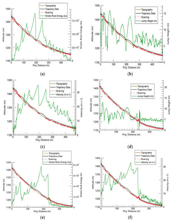
Figure 9.
Rockfall Movement Curves: (a) WY3 Rockfall Kinetic Energy-Position; (b) WY3 Curve Rockfall Bounce Height-Position; (c) WY3 Curve Rockfall Velocity vs. Position Curve; (d) WY6 Rockfall Kinetic Energy-Position (e) WY6 Curve Rockfall Bounce Height-Position; (f) Curve Rockfall Velocity vs. Position Curve.
To assess the potential threat of rockfalls to residents near the slope toe of the Lujiawan resettlement area, six rockfall sources were classified into risk levels based on the energy classes of flexible barriers defined in EAD 340059-00-0106 [] (Class A: ≤ 500 kJ/≤ 10 m/s; Class B: ≤ 1000 kJ/≤ 20 m/s; Class C: ≤ 2000 kJ/≤ 30 m/s; Class D: ≥ 2000 kJ/≥ 30 m/s). A Monte Carlo uncertainty analysis was performed, incorporating ±10% variation in kinetic energy and ±15% in bounce height. Additionally, a sensitivity analysis was conducted to evaluate the impact of a 20% increase in moisture content, which could raise kinetic energy by 5–10% and extend flight distance by 3–8%. Based on these analyses, the following mitigation strategies are proposed:
WY1 (3 × 10⁵ kJ, 8 m/s, 6 m) is located at the boundary between Class A and Class B. Its energy dissipates rapidly upon entering the gentler slope section, showing no significant potential for further travel. A low- to medium-energy flexible barrier (Class A/B, Level 1–2) is recommended at the slope toe-to-downstream transition zone, supplemented with surface drainage measures to intercept blocks early and dissipate residual energy on site.
WY2 (2.3 × 10⁶ kJ, 41.7 m/s, 25 m) exceeds the upper threshold of Class C and presents the highest risk among all sources. Elevated moisture content may further increase its kinetic energy and extend its travel distance. High-energy flexible barriers (Class D/E, Level ≥3–4) are recommended at the slope outlet and within 200 m downstream, supplemented with energy-dissipating trenches or retaining structures. A sufficient buffer zone should be reserved to absorb peak energy and mitigate high-velocity impacts. WY2 should be prioritized in hazard mitigation planning.
WY3 (1.55 × 10⁶ kJ, 34.8 m/s, 18 m) is also classified as high risk (Class C). Although its energy attenuates before reaching the slope toe, the block retains sufficient momentum to potentially overtop the barrier. As with WY2, high-energy barriers (Level ≥ 3) should be installed at the slope outlet and critical toe locations, supplemented by toe reinforcement and surface drainage. WY3 is recommended as the second-highest priority for mitigation.
WY4 (8 × 10⁴ kJ, 5 m/s, 3 m) exhibits the highest stability, with both kinetic energy and velocity well within Class A thresholds and no risk of airborne movement. A low-profile Class A barrier (Level 1)—such as a short flexible net or stone bund—is sufficient, particularly when combined with existing drainage or retaining structures. High-energy protection is not required.
WY5 (8.9 × 10⁵ kJ, 22 m/s, 12 m) falls between Class B and Class C and is considered a moderate-risk source. While it poses a potential threat to the infrastructure, its energy is substantially lower than that of high-risk blocks. A Level 2 medium-energy barrier (Class B/C) is recommended at the slope outlet or key toe locations, supplemented by trench reinforcement to ensure effective interception.
WY6 (1.95 × 10⁶ kJ, 33 m/s, 20 m) is also classified as high risk (Class C). Although its energy attenuates after multiple impacts, it retains considerable destructive potential. A high-energy barrier (Level ≥ 3) is recommended along the mid-to-lower slope transition zone, supported by energy-absorbing trenches or retaining structures. Barrier specifications should be determined based on peak energy values with an added safety margin. WY6 should be prioritized for mitigation alongside WY2 and WY3.
The proposed integrated classification and protection scheme complies with international barrier energy standards and incorporates both uncertainty and seasonal sensitivity analyses, thereby offering a robust safety margin in design. This approach ensures effective rockfall interception and reliable protection of slope-foot residents across diverse operational scenarios.
The Lujiawan resettlement area is characterized by steep terrain, where prolonged human activity and rock mass weathering have destabilized multiple hazardous rock masses, leading to varying levels of economic loss for residents along the slope. To quantitatively and visually assess the rockfall threat to the downslope area of the resettlement site, this study performed detailed trajectory analyses for WY3 and WY6—two rock masses with the steepest slope angles and largest volumes. As illustrated in Figure 9, the energy–velocity–rebound height profiles reflect the dynamic evolution of energy accumulation and dissipation during the rockfall process. Comparative analysis further indicates that WY2 exhibits a similar acceleration trend to WY3 and WY6 during descent but with even higher rebound heights—indicating comparable or greater overflight and impact potential. Therefore, WY2 should be prioritized alongside WY3 and WY6 in hazard classification and mitigation planning. These findings not only refine the quantitative understanding of WY3 and WY6, but also provide strong numerical evidence supporting the classification of WY2 as a high-risk source—highlighting the urgent need for timely mitigation interventions.
4. Discussion
This study advances rockfall risk assessment for steep residential slopes by integrating centimeter-resolution LiDAR-derived topography with the six-degree-of-freedom dynamic solver in RAMMS::ROCKFALL. The 3D simulations conducted for WY1–WY6 reveal critical relationships among kinetic energy, velocity, and bounce height—patterns that traditional 2D models fail to capture, particularly with respect to lateral dispersion and energy dissipation through repeated impacts.
Advancements over Existing Models: Unlike previous studies that relied on simplified geometries or generalized parameters, the LiDAR–RAMMS integration retains detailed micro-topography and enables more reliable reconstruction of rockfall trajectories. This high-resolution modeling improves both spatial accuracy and dynamic fidelity in hazard interpretation.
Engineering Applications: By converting simulated peak kinetic energy and velocity into ETAG 027:2013 barrier classes, we establish a practical risk matrix to support engineering decisions. The matrix enables targeted selection of flexible barriers (Classes A–C) and prioritizes WY2, WY3, and WY6 for immediate mitigation. Sensitivity analyses, incorporating ±10% energy and ±15% bounce variability as well as moisture-induced energy increases, further define conservative design margins for barrier specification and siting.
Study Limitations: Several limitations remain. The current simulations do not account for block fragmentation, seasonal environmental changes, or site-specific damping calibration, all of which may affect runout distances and energy distribution. Additionally, socio-economic vulnerability indicators were not incorporated, which limits the comprehensiveness of risk prioritization.
Future Work: Future research should integrate multi-temporal UAV-LiDAR datasets for time-series monitoring of slope evolution. Coupling discrete fracture network (DFN)–based fragmentation models and Monte Carlo uncertainty frameworks with real-time geotechnical sensor inputs (e.g., InSAR, ground-based radar, etc.) would enable dynamic forecasting of rockfall hazards with probabilistic confidence.
Conclusion of the Discussion: In summary, this discussion highlights the methodological innovations, practical benefits for engineering decision making, and critical avenues for future refinement. The proposed LiDAR–simulation framework offers a robust foundation for improving rockfall hazard management in complex mountainous environments.
5. Conclusions
This study employs high-resolution airborne LiDAR to reconstruct micro-topography and, for the first time, integrates mechanistic failure identification, qualitative and quantitative stability assessments, and RAMMS::ROCKFALL-based 3D rockfall dynamics into a unified analytical framework. We quantitatively analyzed the failure probabilities and relative risk rankings of WY1–WY6 under combined rainfall–seismic loading and employed 3D simulations to reveal the spatial evolution of block kinetic energy, velocity, and bounce height—thereby informing barrier design based on peak impact metrics. Based on these findings, we propose a tiered protection strategy of “zoned barriers with in situ energy dissipation”, enabling differentiated mitigation for large, complex slopes with densely distributed assets. By advancing both methodology and application, this work enhances the reliability of slope–rockfall hazard assessment and provides a clear technical roadmap and decision-support framework for future protection design and risk reduction planning. Nevertheless, this study lacks field-calibrated monitoring data, and potential errors introduced during data acquisition and processing may influence the accuracy of the risk assessments. Future work will involve the deployment of high spatiotemporal resolution displacement and strain monitoring systems, as well as the use of Monte Carlo simulations or Bayesian inference to enhance sensitivity and uncertainty analyses—thereby improving the scientific rigor and reliability of stability assessments and mitigation designs.
Author Contributions
Conceptualization and software, R.Z.; methodology, R.Z.; data curation, R.Z., S.Z. and Y.W.; formal analysis, R.Z.; writing—original draft preparation, R.Z.; writing—review and editing, R.Z., Y.X., S.Z. and Y.W.; resources, S.Z. and Y.W.; supervision, Y.X.; project administration, Y.X. All authors have read and agreed to the published version of the manuscript.
Funding
This research was funded by the National Natural Science Foundation of China (grant numbers 41861054, 42161067 and 42404055), by the Qiubei County Wenliu Township Huajiao Village Committee (grant number KKF0202456041), and 3D Modeling and Topographic Mapping of the Preliminary Assessment Area for Geological Hazard Risks on the Left Bank of the Wudongde Hydropower Reservoir (Huidong Section) (KKF0202556111).
Institutional Review Board Statement
Not applicable.
Informed Consent Statement
Not applicable.
Data Availability Statement
The original contributions of this study are provided in the main article. Additional inquiries may be directed to the first author.
Acknowledgments
The authors express their sincere gratitude to Xia for her invaluable guidance throughout this research. The authors also extend their appreciation to the editor and anonymous reviewers for their insightful comments and constructive feedback, which have significantly enhanced the quality of this work.
Conflicts of Interest
Authors Shucai Zhang and Yingke Wang were employed by Yunnan No. 2 Geological Engineering Investigation Institute Co., Ltd., Chuxiong, Yunnan 675000, China. Rao Zhu, Yonghua Xia, Shucai Zhang, and Yingke Wang declare that the research was conducted in the absence of any commercial or financial relationships that could be construed as potential conflicts of interest. The authors further confirm that they have no conflicts of interest to declare.
References
- Huang, Q.N. Development Characteristics and Formation Mechanism of Landslides, Collapses and Dangerous Rock Geological Disasters. China Resour. Compr. Util. 2020, 38, 158–165. [Google Scholar]
- Zheng, G.; Xu, Q.; Ju, Y.; Li, W.; Zhou, X.; Peng, S. The Pusacun Rock Avalanche on 28 August 2017 in Zhangjiawan, Nayong County, Guizhou: Characteristics and Failure Mechanism. J. Eng. Geol. 2018, 26, 223–240. [Google Scholar] [CrossRef]
- Wu, X.; Liu, H.; Wang, R.; Wang, Y.; Tu, X. Approach of Rock-Collapse (Rockfall) Identification and Prediction for Power-Transmission Projects in Mountain Areas. J. Eng. Geol. 2018, 26, 172–178. [Google Scholar] [CrossRef]
- Li, L.; Lan, H. Probabilistic Modelling of Rockfall Trajectories: A Review. Bull. Eng. Geol. Environ. 2015, 74, 1163–1176. [Google Scholar] [CrossRef]
- Fanos, A.M.; Pradhan, B. Laser-Scanning Systems and Techniques in Rockfall Source Identification and Risk Assessment: A Critical Review. Earth Syst. Environ. 2018, 2, 163–182. [Google Scholar] [CrossRef]
- Borja Bernal, C.P.; Jordá Bordehore, L. Application of the Kinematic Assessment of Multi-Faced Slopes Using Stereographic Projection: A Planar-Failure Case on the Spondylus Coast, Ecuador. Appl. Sci. 2023, 13, 8245. [Google Scholar] [CrossRef]
- Grechi, G.; D’Angiò, D.; Martino, S. Analysis of Thermally Induced Strain Effects on a Jointed Rock Mass through Microseismic Monitoring at the Acuto Field Laboratory (Italy). Appl. Sci. 2023, 13, 2489. [Google Scholar] [CrossRef]
- Nkanyane, F.; Mashala, P.; Adepoju, O.; Musakwa, W.; Zvarivadza, T.; Pretorius, W. The Effects of Strata Orientation and Water Presence on the Stability of Engineered Slopes Using DIPS and FLAC-Slope: A Case Study of Tubatse and Fetakgomo Road Slopes. Appl. Sci. 2024, 14, 9838. [Google Scholar] [CrossRef]
- Ge, Y.; Xia, D.; Tang, H.; Zhao, B.; Wang, L.; Chen, Y. Intelligent Identification and Extraction of Geometric Properties of Rock Discontinuities Based on Terrestrial Laser Scanning. J. Rock Mech. Eng. 2017, 36, 3050–3061. [Google Scholar] [CrossRef]
- Wang, Y.; Shen, Y. Intelligent Identification of Rock Discontinuities Based on Three-Dimensional Laser Scanning Technology. Laser Optoelectron. Prog. 2024, 61, 1412005. [Google Scholar] [CrossRef]
- Dong, X.J.; Huang, R. Application of 3D Laser Scanning Technology to Geologic Survey of High and Steep Slopes. J. Rock Mech. Eng. 2006, 25 (Suppl. S2), 3629–3635. [Google Scholar]
- Li, M.; Xiu, Z.; Han, J.; Meng, F.; Wang, F.; Ji, H. Characterization and Stability Analysis of Rock Mass Discontinuities in Layered Slopes: A Case Study from Fushun West Open-Pit Mine. Appl. Sci. 2024, 14, 11330. [Google Scholar] [CrossRef]
- Xu, D.; Zhang, S.; Liu, L.; Feng, X.; Li, S.; Wu, S.; Qiu, S.; Zhou, Y.; Gao, Y. In-Situ Testing Technique for Tunnel Deformation and Structural Planes of Rock Mass Based on Contactless Laser Scanning and Its Application. Chin. J. Geotech. Eng. 2018, 40, 1336–1343. [Google Scholar] [CrossRef]
- Dong, Z. Research on Methods for Extracting and Analysing Geometric Characteristics of Rock Mass Structures Based on 3D Point-Cloud Information. Master’s Thesis, Dalian Maritime University, Dalian, China, 2024. [Google Scholar]
- Gu, Q.; Li, J.; Chen, L.; Zhu, H. Small-Scale Rockfall Detection Method Based on Solid-State LiDAR for Unstructured Transportation Roads in Open-Pit Mines. Laser Optoelectron. Prog. 2024, 61, 229–234. [Google Scholar] [CrossRef]
- Jia, Y.; Xia, Y.; Lü, J.; Zhao, C. Enhanced Display and Identification of Hidden Landslides Based on Airborne LiDAR. Laser Optoelectron. Prog. 2024, 61, 2428012. [Google Scholar] [CrossRef]
- Chen, G.; Zheng, L.; Zhang, Y.; Wu, J. Numerical Simulation in Rockfall Analysis: A Close Comparison of 2-D and 3-D DDA. Rock Mech. Rock Eng. 2013, 46, 241–258. [Google Scholar] [CrossRef]
- Zhang, Y.; Xie, W.; Luo, Z.; Zhai, S. Stability Evaluation and Rockfall Trajectory Analysis of the Baimagou Dangerous Rock Mass in Mingshan County of Sichuan Province. Chin. J. Geol. Hazard Control 2022, 33, 37–46. [Google Scholar] [CrossRef]
- He, Y.; Pei, X.; Liang, J.; Gu, H. Risk Assessment and Range Prediction of Dangerous Rockmass Based on Rockfall: A Case Study of the Xuangou Collapse. Chin. J. Geol. Hazard Control 2020, 31, 24–33. [Google Scholar] [CrossRef]
- Li, Y.; He, K.; Hu, X.; Liu, B.; Zhou, R.; Wen, Q. Formation Characteristics and 3-D Kinematic Simulation of Rockfall Evolved from Shattered Mountain: Sanguanmiao Village Case, Wenchuan County. J. Eng. Geol. 2022, 30, 542–552. [Google Scholar] [CrossRef]
- Wang, Y.; Zhang, Y.; Wang, Y. Stability of Dangerous Rock Masses and Prediction of Rockfall Trajectories: Wansui Mountain, Ganzi County, Sichuan. J. Geol. Hazards Prev. 2024, 35, 12–25. [Google Scholar] [CrossRef]
- Hao, J.; Zhang, X.; Wang, C.; Wang, H.; Wang, H. Application of UAV Digital Photogrammetry in Geological Investigation and Stability Evaluation of High-Steep Mine Rock Slope. Drones 2023, 7, 198. [Google Scholar] [CrossRef]
- Cirillo, D.; Zappa, M.; Tangari, A.C.; Brozzetti, F.; Ietto, F. Rockfall Analysis from UAV-Based Photogrammetry and 3-D Models of a Cliff Area. Drones 2024, 8, 31. [Google Scholar] [CrossRef]
- Massaro, L.; Forte, G.; De Falco, M.; Rauseo, F.; Santo, A. Rockfall Source Identification and Trajectory Analysis from UAV-Based Data in Volcano-Tectonic Areas: Ischia Island, Southern Italy. Bull. Eng. Geol. Environ. 2024, 83, 75. [Google Scholar] [CrossRef]
- Minervino Amodio, A.; Corrado, G.; Gallo, I.G.; Gioia, D.; Schiattarella, M.; Vitale, V.; Robustelli, G. Three-Dimensional Rockslide Analysis Using Unmanned Aerial Vehicle and LiDAR: The Castrocucco Case Study, Southern Italy. Remote Sens. 2024, 16, 2235. [Google Scholar] [CrossRef]
- GB 50330-2013; Technical Code for Building Slope Engineering. The Standardization Administration of China: Beijing, China, 2013.
- GB 18306-2015; Seismic Ground Motion Parameters Zonation Map of China. The Standardization Administration of China: Beijing, China, 2013.
- Leine, R.I.; Schweizer, A.; Christen, M.; Glover, J.; Bartelt, P.; Gerber, W. Simulation of Rockfall Trajectories with Consideration of Rock Shape. Multibody Syst. Dyn. 2014, 32, 241–271. [Google Scholar] [CrossRef]
- Wang, M.; Cao, X.; Qiao, L. Comprehensive Analysis of Hazardous Rock Mass and Simulation of Potential Rockfall Processes Using a 3-D Terrain Model: High Cut-Slope Near a Hydropower Station, Southern China. J. Geol. Hazards Prev. 2023, 34, 86–96. [Google Scholar] [CrossRef]
- ETAG 027:2013; Guideline for European Technical Approval of Falling Rock Protection Kits. European Organisation for Technical Approvals (EOTA): Brussels, Belgium, 2013.
Disclaimer/Publisher’s Note: The statements, opinions and data contained in all publications are solely those of the individual author(s) and contributor(s) and not of MDPI and/or the editor(s). MDPI and/or the editor(s) disclaim responsibility for any injury to people or property resulting from any ideas, methods, instructions or products referred to in the content. |
© 2025 by the authors. Licensee MDPI, Basel, Switzerland. This article is an open access article distributed under the terms and conditions of the Creative Commons Attribution (CC BY) license (https://creativecommons.org/licenses/by/4.0/).