Abstract
The present study is part of the context in which Romania adopted the European Parliament Directive 2007/60/EC on flood risk assessment and management. Therefore, the aim of this research is to assess the risk induced by a hydrological hazard, expressed by a financial value estimation, for the Turcu River in the northern sector of the Bran–Dragoslavele transcarpathian corridor (Romania), an important tourist axis where the pressure on land has increased considerably. As a result, the intra-village areas of Moieciu de Sus, Cheia, Moieciu de Jos, Bran and Tohanu Nou have also expanded into areas vulnerable to flooding. There are currently no studies on the areas potentially affected as well as the extent of the possible damage. For this reason, we proceeded to model the water level corresponding to the maximum flow value with a probability exceeding 1%, using HEC-RAS and ArcGIS software. The results of the implementation of the spatial analysis model resulted in the delineation of the floodplain and the assessment of the potential financial loss related to the minimum market value of the land with the related real estate infrastructures. The research reveals that in the 1% band area (78.7841 ha) with water depth > 0.5 m, more than 433 infrastructures are at high risk of flooding, most of them with high real estate value, i.e., 5.61 km of roads for which a cost of EUR 3,402,666.90 was calculated for restoration. A knowledge of financial vulnerability to flooding becomes important for the community; local authorities involved in making decisions for insuring real estate at risk and planning/managing investments work to prevent/combat the effects of flooding.
1. Introduction
Over the last 50 or 60 years or so, global warming has been increasingly felt. It has imposed regional climate change on continents, leading to drought and desertification as well as catastrophic floods. Floods, as periodic hazards with natural causation, have been recorded all over the world, and Central-Eastern Europe, including Romania, has been no exception [1,2,3,4,5].
Floods can become disastrous when they cause significant material damage and loss of life [6]. In affected areas, an important step in flood risk management includes the prevention and minimization of financial losses [7], but also the development of innovative financial mechanisms and instruments that a central public administration can adopt in particularly exposed regions [8,9].
Flooding has also become one of the major legislative concerns of the European Union, and Directive 2007/60/EC [10,11] has been issued to all Member States. This refers to the assessment and management of flood risk through the production of hazard maps and corresponding risk maps for areas with potentially significant vulnerability [12]. The maps produced become an important tool for communicating flood risk to the various public administrations involved, which are national water management authorities, civil protection institutions, prefectures with decision-making competence for larger territories, town halls, insurance companies, etc. [13].
In the context presented, the concerns for the realization of flood hazard maps are based on methodologies and computational algorithms implemented in hydraulic modeling software integrated into Geographic Information Systems (GIS), the most popular of which are HEC-RAS, MIKE SHE and LISFLOOD-FP, which are designed for the realization of flood belts, or for the modeling and visualization of realistic and efficient simulations related to the flooding of major riverbeds [14,15,16,17,18]. The results are constituted as elaborate and structured databases in a GIS environment. They represent the scientific foundation supporting efforts to understand the phenomenon in depth, but also aim to mitigate the effects of floods, in conjunction with the mitigation of material damage and human casualties [19].
The development of hazard and flood risk maps is a complex algorithm in which certain techniques implemented by methods, such as hydrological and hydraulic modeling, are applied based on a set of topographic data describing the drainage channel terrain and water discharge areas with a certain accuracy required by the type and accuracy of the numerical terrain model [20].
The methods used for the observation of flooded or potentially flooded areas range from in situ monitoring based on real-time images from visual sensor cameras [21,22,23], to the use of satellite images [24,25,26], to those using digital elevation models (DEM) from remote sensing [27,28,29]. In the current research, DEM has been performed by interpolating the levelling and drainage network extracted from topographic maps at a scale of 1:25,000 using the Topo to Raster tool implemented in ArcGIS/ArcMap software 10.8.2 [30]. In order to increase the pixel resolution and hence the detail of the resulting modeling, data extracted from maps at a more detailed scale can also be used. Frequently used are digital elevation models made by measurements taken with LIDAR scanning [31,32,33], as they are able to generate a higher spatial resolution than numerical models obtained by the interpolation of levelling and drainage network.
The hydraulic modeling presented in the current research was performed using the Hydrologic Engineering Center River Analysis System (HEC-RAS) application, a free source software [34] most commonly used in studies aimed at hazard and flood risk mapping [35,36,37,38], and officially accepted by government agencies and developed by the Hydrologic Engineering Center of U.S. Army Corps. HEC-RAS allows the integration of GIS spatial databases through the HEC-GeoRAS extension belonging to the ArcGIS/ArcMap program. Three types of hydraulic and hydrodynamic models can be used for hydraulic modeling: one-dimensional (1D) [39,40], two-dimensional (2D) [41,42], combined (1D/2D) [43,44] and three-dimensional (3D) [45]. For the analysis carried out in the 1% flood band of the Turcu River (Olt basin, Romania), the 1D model could be successfully used, which is easy to generate [46], process and use, but, compared to the other models, it has the disadvantage of some limitations, such as the inability to simulate lateral flood wave diffusion and vertical turbulence.
The 1D hydraulic and hydrodynamic model was chosen not only because it is commonly used, but also because of its efficiency in terms of processing input data on hardware with relatively modest functional characteristics. One-dimensional modeling also remains suitable for flood simulation because it is easy to generate and use. One of the main advantages unanimously recognized is its efficiency in terms of computation time. Another main advantage is that the 1D model is suitable for use in morphologically well-defined riverbeds with relatively close, bilaterally distributed terrace heads and/or slopes where river flow and overflow do not spread significantly. Such conditions are also valid for the Turcu mountain valley, whose floodplain is clearly delimited laterally and has a width from 50 m to 450 m, approximately.
At the national level (Romania), the National Administration “Romanian Waters” (A.N.A.R.) was implemented in the 2014 Directive 2007/60/EC. For the creation of hazard maps, a group of specialists, formed at the level of A.N.A.R. and the National Institute of Hydrology and Water Management (I.N.H.G.A.), used the results obtained within the National Programme Plan for the Prevention, Protection and Mitigation of Flood Effects (P.P.P.P.D.E.I.) [47,48], based on hydraulic modeling methods and using the HEC-RAS application by constructing and exploiting the one-dimensional (1D) hydrodynamic model; the results of simplified methods for generating flood curves were applied in areas that were not covered by the P.P.P.D.E.I. This concerned watercourses not modeled in the P.P.P.D.E.I., but with relatively large catchment areas or characterized by extensive flood zones (Târnava Mică, Teuz, etc.). It was noted that the effects of climate change were not taken into account in the modeling and analysis that were carried out [49].
Also, at a national level, for the risk maps, the degree of risk was taken into account according to water depth, establishing three classes (low risk < 0.5 m, medium risk 0.5–1.5 m and high risk > 1.5 m). However, according to the developed risk matrix [49,50], four flood risk guards were established: 0—insignificant residual risk (agricultural and other land at the edge of settlements), 1—low risk, 2—medium risk and 3—high risk. The approach in the current research is based on the delineation of two water depth ranges (<0.5 m and >0.5 m) within the 1% flood belt and the intersection of their areas with the mapped intra-urban space for the five localities crossed by the Turcu River in the belt area, in order to delimit the risk classes: high, medium, low and residual risk. The insignificant surface of the floodplain area >1.5 m suggested the modification made to the national approach.
The resulting national hazard and risk maps [51] were developed for three flooding scenarios, low, medium and high probability, for peak flows with a probability of the exceedance of 0.1%, 1% and 10% having a corresponding statistical return period once every 1000, 100 and 10 years. For the same maps, the hydraulic modeling to define the 1% floodplain of the Turcu River was based on the value of the maximum flow with 1% exceedance probability, Q1% = 230 m3/s, recorded at the hydrometric station (SH) of Tohanu Nou (Brasov county) [52]. Measured at the same station, the value of the historical maximum flow Q of 120 m3/s, recorded on 2 July 1975, is also known. For the calculation of the flows with a certain probability of exceedance, which spatially delimit flood bands, Bilașco and Horváth [53] show that it may be necessary to analyze data strings measured at hydrometric stations that represent maximum annual flow values that are subject to frequency analysis methods in hydrology, based on equations defining statistical probability functions [54,55].
The main purpose of the current research is to contribute to the hazard and flood risk maps that are carried out at national level through the case study of the Turcu river sector (20,401 m) located upstream of Tohanu Nou SH and strongly affected by the anthropic pressure generated in the last three to four decades due to the concentration of numerous constructions in the 1% flood area. As a result of the implementation of the study, the national hydrological database held by ANR and I.N.H.G.A. was completed with the information resulting from the present research. Moreover, the hazard and flood risk maps for the Turcu River will be able to serve the local authorities involved in the elaboration of intervention plans [56] that are as precise and efficient as possible in the case of disaster. To the same extent, the cartographic materials produced can also support the planning–management activity of local strategies for carrying out investment works to prevent and combat the effects of floods.
The implementation of the study will allow, on the one hand, for the estimate of the cost of the potential financial loss (minimum values) for the land and related real estate infrastructure, located in the 1% flood belt of the Turcu River. In case of a flood disaster, the amount of the estimated cost could be compensated from the state budget or from local budgets, as an insurance fund based on the mandatory insurance policy against natural disasters—PAD, valid in Romania.
On the other hand, the implementation of the study will also allow for the estimate of the cost of the potential financial loss related to the road segments intersected by the 1% flood belt, with water depth > 0.5 m, which could be approved by the County Council of Brasov as an insurance fund for the restoration of the public roads possibly affected.
The flood hazard and related financial loss on the Turcu River is looming as an imminent phenomenon. It will occur along a tourist route of local and national importance that is intensively frequented by tourists and mainly in the Carpathian area of the Bran–Dragoslavele Corridor (Romania).
2. Materials and Methods
2.1. Study Area
The hazard and flood risk analysis presented in the current research includes a section of the Turcu River in the Olt river basin (Romania) with a length of 20,401 m out of a total of 29,059.58 m, between SH Tohanu Nou (45°33′8.679″ N, 25°23′0.314″ E) and the intra-village area of Moieciu de Sus (45°25′23.386″ N, 25°21′53.774″ E) (Figure 1). The implementation of the one-dimensional hydrological model revealed the 1% flood belt crossing from downstream to upstream in the villages of Tohanu Nou (part of the town of Zărnești), located in the west of the Brașov intramontane depression, on the lower course of the Turcu river; Bran (commune of Bran), Moieciu de Jos, Cheia and Moieciu de Sus (commune of Moieciu); and villages located in the area of the Bran–Dragoslavele Corridor, on the middle course of the same river.
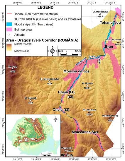
Figure 1.
Location of the 1% floodplain on the Turcu River (Olt basin) from the Bran–Dragoslavele Corridor (Romania).
In the area of the mentioned intramontane corridor, the hazard and flood risk maps of the national project were made along the Dâmbovița river, between the center of the Rucăr commune and Lunca Gârții village (Stoenești commune). The other main fluvial axis of the intramontane corridor is the valley of the Turcu River which gathers tributaries from the eastern flank of the Piatra Craiului syncline, the northern slope of the Leaota Mountains and the north-western slope of the Bucegi Mountains. This mountain valley, with an obvious flooding potential, has, so far, not come to the attention of the specialists who have made flood risk maps at a national scale, considering only that “not covering an area of our country does not lead to the conclusion that the area in question cannot be exposed to flood risk” [51].
2.2. Methodology and Database
The development of flood hazard and risk maps should show several important elements of flood scenarios: flood extent, water surface elevation, water depth and flow at different critical cross sections. In order to achieve the main purpose of this work, several methodological steps have been followed (Figure 2).
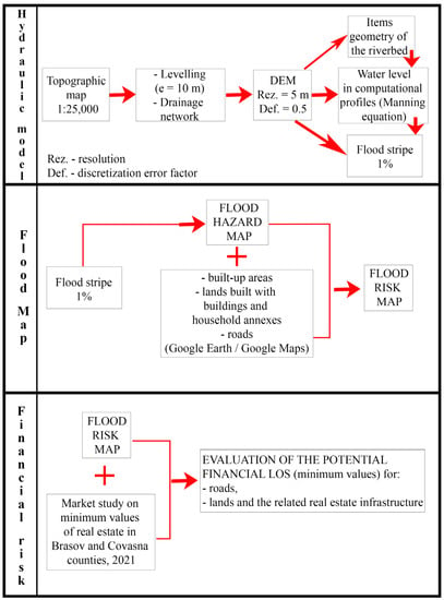
Figure 2.
Methodological Workflow.
The first stage consisted of delineating the 1% floodplain using the HEC-GeoRAS extension for Esri ArcGIS v.10.8 and HEC-RAS v.5.0.7.
The numerical elevational terrain model used to build the hydrographic database and finally the 1% floodplain was designed with a spatial resolution of 5 m and a discretization error correction coefficient of 0.5, by interpolating the levelling and drainage network taken from military topographic maps at a scale of 1:25,000 [57], with a contour equidistance equal to 10 m. The interpolation method was specifically designed for the creation of hydrologically correct digital elevation models (DEMs) and implemented in ArcGIS/ArcMap software that is accessible through the Topo to Raster tool. It is based on the ANUDEM program developed by Michael Hutchinson (1988, 1989, 1996, 2000, 2011) [30].
The first sub-stage consisted of the creation of the bed geometry elements using the HEC-GeoRAS extension for Esri Arc GIS. The hydrographic database was obtained: the hydrographic network (Stream Centerline), the banks of the drainage channel (Bank Lines), the 20,401-meter-long Flow Path Channel, the maximum extension of the study area (Flow Paths Left and Right) and 139 of the cross-sectional profiles of the computational sections (XS Cut Lines). After the creation of the attribute database, specific to both the hydrographic network and the cross-sectional profiles, the databases were exported from the shapefile format (.shp) to the RAS data format, to be run and used in the HEC-RAS program.
The second sub-stage allowed the determination of the water level in the profiles based on the Manning equation (Q = A/n ×R⅔ × S½, where Q is the river flow, A—the surface of the drainage profile, R—the hydraulic radius, S—the bed slope and n—Manning’s roughness coefficient) implemented in the HEC-RAS program. The following operations were performed to accomplish this: importing the GIS databases (obtained in the first sub-stage) related to the riverbed geometry through the Geometric Data module; filling the tabular database with Manning’s roughness coefficient [53,58] for each profile (for riverbed, left and right banks/sides); performing the flow calculations and tabulating them for each profile in the Steady Flow Data module; performing the bed slope calculations (downstream–downstream and upstream–upstream) for the 11 sectors of the slope network, followed by entering the results in the Steady Flow Data module window. Water level results were obtained for each profile by running the hydraulic model in the Steady Flow Analysis module.
The third sub-stage allowed for the visualization of the hydraulic model results (HEC-RAS); export of the databases from RAS format to GIS format (.shp) to be imported, run and used in the HEC-GeoRAS extension; modeling of the 1% floodplain, resulting in vector and corresponding raster databases.
In the second stage, a flood hazard map was produced for the Turcu River in the 1% floodplain area, as previously defined. Within it, the hazard magnitude was established for three ranges of water depth, according to the methodology implemented at a national level: <0.5 m, 0.5–1.5 m and >1.5 m.
In the third stage, a flood risk map was produced based on two water depth intervals (<0.5 m and >0.5 m) within the 1% flood belt and the intersection of their areas with the mapped intra-urban space for the 5 localities crossed by the Turcu River in the belt area, in order to delimit the risk classes: high—corresponding to the 1% floodplain with water depth > 0.5 m in the intra-urban area; medium—corresponding to the 1% floodplain with water depth < 0.5 m in the intra-urban area; low—corresponding to the 1% floodplain in the extra-urban areas of the five localities. Residual risk means overflow into the floodplain in the extra-village area, without causing material damage. At the national level, in accordance with Directive 2007/60/EC, the risk level was taken into account for the flood risk maps according to the magnitude of the hazard, establishing three classes according to the water depth: <0.5 m, low risk, with low impact on human population, economic, socio-cultural activities and geographical environment; 0.5–1.5 m, medium risk, with medium to high impact; >1.5 m, high risk, with very high impact.
In the fourth step, the potential financial loss expressed in RON (Romanian Leu) and EURO (European single currency) for roads, land and related real estate infrastructure (mapped from recent satellite images) intersected with the 1% floodplain area was assessed. The exchange rate communicated by the National Bank of Romania on 15 November 2022, 1 EURO = 4.9032 RON (lei), was used for the calculations.
In order to highlight the vulnerability of land and related real estate infrastructure, the assessment of the potential financial loss (minimum values) to flooding was carried out by going through three sub-stages of work: first—inventory of the infrastructure categories in the 1% flood belt area by mapping them based on satellite images (16 September 2019, 27 August 2020 and 21 September 2020) available through the Google Earth Pro application [59], corroborated with information from the Google Maps application database [60]; second—assignment of the minimum financial value (RON) [61] for all infrastructure categories mapped in the first stage; third—calculation of the potential financial loss (minimum values) to flooding for the inventoried building yards and all related infrastructure categories, as well as the breakdown of its results into the risk classes established in the third stage.
Three calculation formulas were used to assess the potential financial loss (minimum values), calculated in RON. The first refers to the potential financial loss (minimum values) for land built with residential buildings (PFcl), PFcl = Scl/1.40 × (C1 + C2)/2 + Tcc × Vmtc, where Scl—constructed area with residential buildings (m2) and Scl/1.40 = Su (usable area, m2); C1(2)—building type 1(2) and (C1 + C2)/2 is the average minimum value of residential buildings (lei/m2 of Su); Tcc—land courtyard buildings = Sc (m2); Vmtc—minimum value of land courtyard buildings (lei/m2), Tcc = Sc (lei/m2). The second, refers to the potential financial loss (minimum values) for land built with household annexes (PFag), PFag = Sca × (A1 + A2)/2 + Tcc × Vmtc, where Sca—built-up area with household annexes (m2); Sca = Sc (built-up area, m2); A1(2)—household annex building type 1(2) (A1 + A2)/2 is the average minimum value of household annexes (lei/m2 of Sc); Tcc—land courtyard building = Sc (m2); Vmtc—minimum value of land courtyard building (lei/m2), Tcc = Sc (lei/m2). The third refers to the potential financial loss (PFec) (minimum values) for infrastructure built as spaces with economic (commercial—com. and industrial—ind.), social-cultural (s.c.) and non-economic (a.d.) use, PFec = Sce/1.40 × Vmi + Tcc × Vmtc, where Sce—built area with infrastructure in the categories com., ind., s.c. and a.d. (m2); Sce/1.40 = Su (useful area, m2); Vmi—minimum value (lei/m2 of Su) of infrastructure built as spaces with com., ind., s.c. and a.d. destination; Tcc—building yard land = Sce (building footprint, m2); Vmtc—minimum value of building yard land (lei/m2).
The potential financial loss for road segments intersected by the 1% floodplain area with water depth > 0.5 m was calculated as the product of the length of the potentially affected road segments and the cost of the rehabilitation works. It was based on the actual, known value of the reported cost price per 1 km unit, foreseen in a 2020 execution contract [62], for some rehabilitated/upgraded county roads in Brasov County (Romania).
3. Results
The results obtained as a result of the implementation of the methodology are able to show the extent of the vulnerability to flooding of land and related infrastructure found in the 1% floodplain modeled for the middle-lower Turcu valley. Along this valley, there is a single road artery crossing five municipalities whose settlement areas are mainly concentrated in the major riverbed, in the vicinity or in the area of hydrological hazard manifestations.
3.1. The 1% Floodplain and Hazard Mapping
The 1% floodplain has been defined dimensionally and spatially by performing hydraulic calculations based on the flow corresponding to the 1% exceedance probability (Q1% = 230 m3/s, recorded at Tohanu Nou SH), with a statistical return period of 100 years.
The topographic data used to build the HEC-RAS one-dimensional model were materialized by a set of 139 cross-sectional profiles, of which 126 were drawn on the Turcu River, over a length of 20,401 m (Figure 3). The average distance between cross-sections on the Turcu River was 161.91 m. The distances between profiles depend on the sinuosity of the river. The method of drawing cross-sections requires that where the river is straighter, the distance between two consecutive cross-sections can be increased. In order to describe more precisely the geometry of the main river channel, additional cross-sections were required on the meandering sections of the river. These sections cover at least the width of the river but also the possible flooding area.
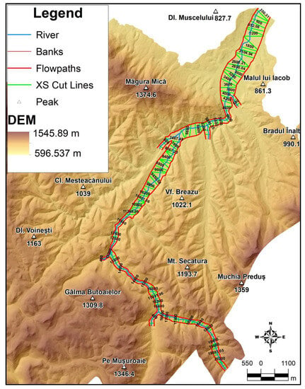
Figure 3.
Geometric model of the river section studied, obtained using the extension HEC-GeoRAS for Esri Arc GIS/ArcMap software.
Field observations have allowed, within the major bed along the profile drawn at Tohanu Nou HS, the identification of relatively thick sapling thickets with rare and young trees (Figure 4). Thus, the values of the Manning roughness coefficient (n), used for the calculations, were taken from the range 0.040–0.080, according to the classification proposed by Chow in 1959 [53,63].
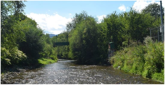
Figure 4.
Minor bed morphology and vegetation characteristics from Tohanu Nou hydrometric station.
For the flow value of 230 m3/s and “n” (Manning’s roughness coefficient) = 0.060, the corresponding water level (h1%) in the design profile was 690.19 m absolute elevation, 2.295 m above the level of the talveg point within the section (Figure 5). The computed elevation values for the plotted cross-sectional profiles refer to the DEM elevation, which shows a tolerable error of about +1 m compared to the GPS measured elevations in the talveg at the Tohanu Nou SH hydrometric sight (687.895 m on the DEM—686.889 m above the Black Sea 1975 Constanta Height Datum, measured with GPS = +1.006 m).
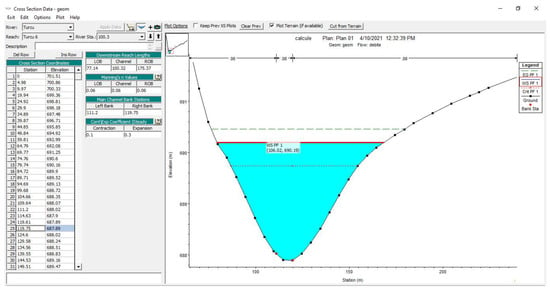
Figure 5.
Highlighted water level (h1% = WS PF1 = 690.19 m) for Q1% (Total Q = 230 m3/s) in the calculation profile of Tohanu Nou SH.
The bed roughness coefficient values are some of the more important aspects of any hydraulic model. They help to correctly define the extent of the floodplain and the velocity of flow in the main river channel. It is almost impossible to determine the roughness by in situ measurements; thus, values of this coefficient are usually estimated from alternative sources such as geological maps, pedological maps, orthophotos or satellite images [64,65]. Based on the geomorphological characteristics of the riverbed, the rock types [66] in which the minor riverbed is deepened and the land cover/use of the major riverbed, as well as roughness coefficient values, were used according to the classification proposed by Chow (Table 1). Satellite images used for the land classification and roughness coefficient assignment were viewed using Google Earth Pro. The images, dated 16 September 2019, 27 August 2020 and 21 September 2020, covered the entire study area.

Table 1.
The “n” coefficients of roughness (Te Chow, 1959).
The use of specialized software allowed for the realization of the defining elements of the bed geometry, the calculation of the water level in the transverse potholes, as well as the visualization of the results of the one-dimensional hydraulic model, resulting in the vector and raster database corresponding to the 1% floodplain. The determination of the hazard magnitude on 3 water depth intervals within the 1% floodplain was suggested by the methodology implemented at a national level. By superimposing the thematic layers related to intra-village areas and roads, the flood hazard map for the Turcu River was obtained (Figure 6, Figure 7 and Figure 8).
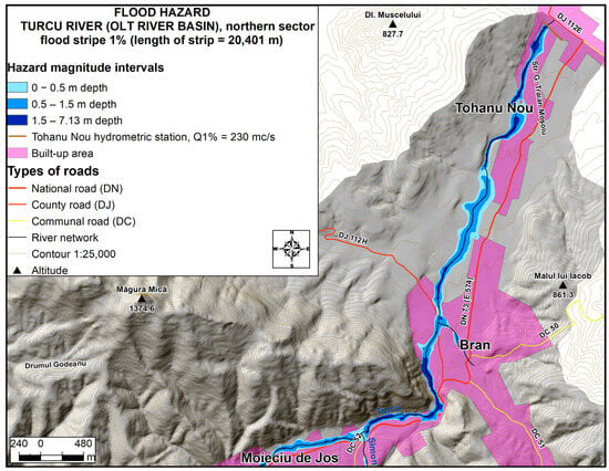
Figure 6.
Flood hazard on the Turcu River, northern sector.
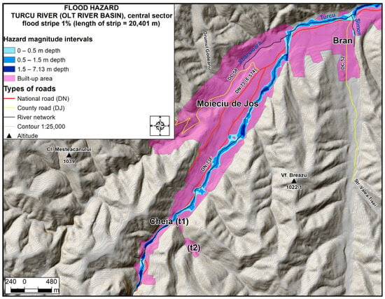
Figure 7.
Flood hazard on the Turcu River, central sector.
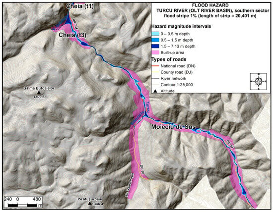
Figure 8.
Flood hazard on the Turcu River, southern sector.
3.2. Evaluation of the Potential Financial Loss (Minimum Values) in Case of Flooding on the Turcu River for the Land and Related Real Estate Infrastructure, Mapped in the 1% Floodplain
The hazard and flood risk analysis along the Turcu River, the sector located upstream of Tohanu Nou SH, was carried out in the 1% flood belt area that crosses from downstream to upstream of the intra-villages of Tohanu Nou (Zărnești town), Bran (Bran commune), Moieciu de Jos, Cheia and Moieciu de Sus (Moieciu commune). For the land and related real estate infrastructure, which are vulnerable and therefore subject to hydrological hazards (flooding from floods and high waters), an assessment of the potential financial loss (minimum values) from floods was carried out. The analysis was based on an inventory of the polygonally represented infrastructural categories (residential buildings, outbuildings, etc.) existing in the floodplain that are identified and mapped on recent satellite images. Thus, the area of the 1% floodplain overlapped the areas of 555 infrastructures distributed within the administrative-territorial units, as follows. In the intra-urban area of Tohanu Nou, the town of Zărnești (Figure 9, Figure 10, Figure 11 and Figure 12), 70 infrastructures were identified, including 68 residential buildings (houses, villas, guesthouses, etc.) and 2 annexes.
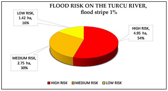
Figure 9.
Turcu River—risk of flooding of land with related real estate infrastructure, mapped in the 1% flood band.
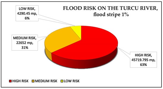
Figure 10.
Turcu River—risk of flooding of land with residential buildings, buildings for commercial, industrial, social-cultural purposes, etc., located in the 1% flood risk zone.
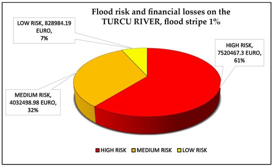
Figure 11.
Turcu River—potential financial loss (minimum values) for land and buildings used for residential purposes, mapped in the 1% floodplain.
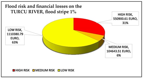
Figure 12.
Turcu River—potential financial loss for land and related real estate infrastructure (commercial, industrial, social-cultural, etc.), located in the 1% flood plain.
In the intra-urban area of Bran, the residence of the homonymous commune (Figure 13 and Figure 14), 87 infrastructures were identified, including 57 residential buildings, 23 household annexes, 6 public institutions (New Orthodox Church, “Queen Mary’s Heart” Chapel, “Sextil Pușcariu” High School Bran—partly in the area of the strip, SRI headquarters in Bran—partly in the area of the strip, Bran Police Station, “Aurel Stoian” public car park—partly in the area of the strip) and one private commercial establishment (“Royalis” textile laundry).
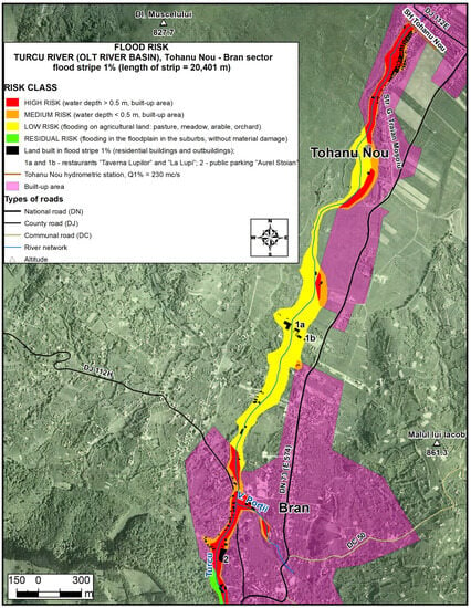
Figure 13.
Flood risk on the Turcu River, Tohanu Nou—Bran sector.
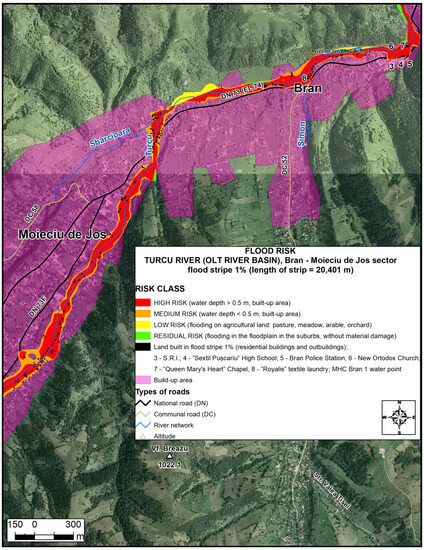
Figure 14.
Flood risk on the Turcu River, Bran—Moieciu de Jos sector.
In the intra-urban area of Moieciu de Jos, residence of the Moieciu commune, 145 infrastructures were identified, including 130 residential buildings and 15 household annexes. In the intra-urban area of Cheia, a village in the commune of Moieciu (Figure 15), 89 infrastructures were identified (57 in the t1 and 32 in the t3), including 75 residential buildings, 13 household annexes and a private industrial unit for the production of bottled mineral water, “Izvorul Moieciu”.
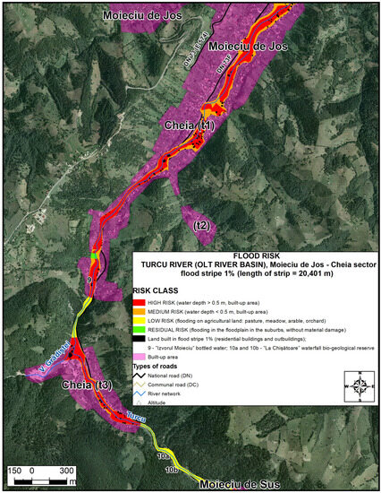
Figure 15.
Flood risk on the Turcu River, sector Moieciu de Jos—Cheia body 3.
In the intra-urban area of Moieciu de Sus, a village in the commune of Moieciu (Figure 16), 139 infrastructures were identified, including 112 residential buildings, 25 household annexes and 2 public institutions (the cultural home and the Moieciu de Sus Secondary School).
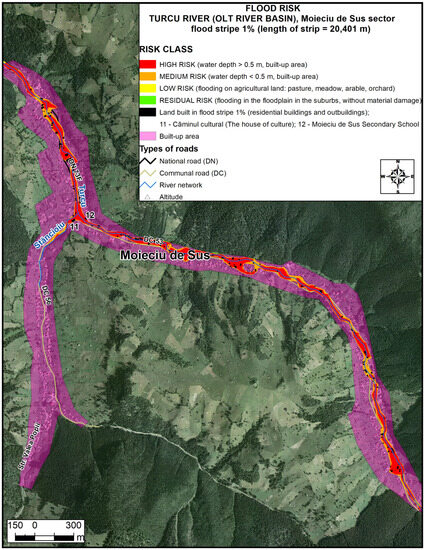
Figure 16.
Flood risk on the Turcu River, Moieciu de Sus sector.
In the exurban area of Tohanu Nou and Bran (Figure 13), 25 infrastructures were identified, including 10 residential buildings, 13 household annexes and 2 commercial establishments (restaurants “Taverna Lupilor” and “La Lupi”). It is illegal to build housing and economic infrastructure on land outside the urban area. Therefore, in the extra-village of Tohanu Nou and Bran, we can admit that the buildings have a building permit attesting their allocation to the adjacent intra-village space, for the purpose of calculating the potential financial loss (minimum values) in case of flooding.
The distribution of the mapped infrastructure within the 1% floodplain, reclassified by water depth intervals, is as follows: 433 infrastructures were identified in the floodplain with water depth > 0.5 m (195 that are fully included) and 360 infrastructures were identified in the floodplain with water depth < 0.5 m (122 that are fully included).
It was found that 238 infrastructures intersect the bands with both depth values, and 75 infrastructures fall partially or entirely within the floodplain band with water depth > 1.5 m.
The Turcu River, in the sector for which the 1% flood band has been created, has an average width of less than 10 m (10.13 m width of the minor riverbed in the profile drawn at Tohanu Nou HS). According to the Water Law 107/1996 (Annex no. 2) [67], concerning the width of protection zones along watercourses, for watercourses less than 10 m wide, starting from the limit of the minor bed, the width of the protection zone is 5 m. By creating a buffer of 10 m width in relation to the central line of the Turcu river, 44 infrastructures were identified and partially located in the area of maximum imminent flood risk; they were found in the intra-village areas, as follows: 32 in Moieciu de Sus, 6 in Cheia, 2 in Moieciu de Jos, 3 in Bran and 1 in Tohanu Nou.
As a continuation of the approach, minimum values expressed in Romanian lei (RON) were assigned for land, courtyards, residential buildings and household annexes, shown in Table 2, as well as for commercial, industrial, social-cultural or other non-economic infrastructure (Table 3, Table 4). The most recent minimum values are valid for 2020 and taken from “Market study on minimum values of real estate in Brasov and Covasna counties, 2021”, Chamber of Notaries Public of Brasov [61].

Table 2.
Flood risk classes. Minimum value assignment for land with related real estate infrastructure, mapped in the 1% flood band.

Table 3.
Evaluation of the potential financial loss (minimum values) to flooding on the Turcu River for the courtyard lands with the related residential buildings and annexes, mapped in the 1% flood band.

Table 4.
Evaluation of the potential financial loss (minimum values) to flooding on the Turcu River for land and related real estate infrastructure, built as commercial, industrial, social-cultural, or other non-economic use, mapped in the 1% floodplain (Figure 12).
Building yards (Tcc) are intra-urban plots of land which have had their category of use changed (originally agricultural land), with or without utilities, and are intended for the construction of buildings and outbuildings, or on which there are such buildings. The minimum value of the land under buildings (land under buildings, outbuildings, parking lots, etc.) will also be allocated according to the area (rural area of Brasov County) of the land. The minimum value of a plot of land is determined on the basis of the unit value per square meter, and expressed in lei/m2 multiplied by the surface area of the land.
Residential buildings (houses, villas, guesthouses, etc.) are classified according to their location in urban or rural localities, according to urban planning zones within municipalities and towns (A, B, C and D); they are subject to the existence of and access to roads and utility networks. Depending on the type of construction, they can be: C1—building with reinforced concrete frames or with external walls made of burnt brick or any other material resulting from thermal and/or chemical treatment; C2—building with external walls made of wood, natural stone, unburnt brick, brickwork or any other material not subject to thermal and/or chemical treatment. The final criteria for classification are the years of construction (from 10 to 30 years old and from 30 to 50 years old) and the average level of finish. The minimum value of residential buildings located in rural areas of Brasov County will be established on the basis of the estimated minimum values per square meter of usable floor area (Su). If the value is not known, according to the specifications of the Romanian Tax Code in force, Su = Scl/1.40, where Scl is the area (m2) built with residential buildings. It should also be noted that the useful floor area (Sud) represents the sum of all the useful floor areas of the building levels.
Household annexes include: garages, summer kitchens, stables with lofts, huts, sheds (crosnie—shed attached to the house, under the roof extension), sheds (polate), storerooms and others that are being built according to the type of construction (A1 and A2, as well as C1 and C2). In the case of outbuildings, the built-up area (Sc) representing the footprint area of the building/annex should be used.
Minimum value of premises for economic use located in rural areas of Brasov County: commercial premises (e.g., “Royalis” textile laundry in Bran and “Taverna Lupilor” and “La Lupi” restaurants in Bran–Tohanu Nou) = 1160 lei/m2 of usable floor area (Su), industrial premises (e.g., “Izvorul Moieciu” bottled mineral water production unit) = 450 lei/m2 of built-up area (Scd). The total floor area is the sum of the areas of all levels of the building, including balconies, loggias or those located in the basement or attic, excluding the areas of attics not used as dwellings, staircases and uncovered terraces.
The minimum value of premises with social-cultural use (churches, cultural home and schools) or other than economic use (SRI headquarters in Bran, Bran Police Station, “Aurel Stoian” public car park and the water intake of the Bran 1 micro-hydroelectric plant), located in the rural area of Brasov County, is reduced by 50% compared to the value of commercial premises corresponding to the urban area (1160/2 = 580 lei/m2 of usable area).
The final step of the approach consisted in calculating the potential financial loss (minimum values) due to floods for the land and related real estate infrastructure in the intra-urban and extra-urban areas of Tohanu Nou, Bran, Moieciu de Jos, Cheia and Moieciu de Sus, all of which are in the 1% floodplain (Table 3 and Table 4, and Figure 10 and Figure 11).
The magnitude of the natural flood hazard, plotted against the range of water depths, led to the establishment of three risk classes: high, medium and low (Table 2), plus the residual risk. Within the three classes, the potential financial loss (minimum values) was also calculated for the land yards, buildings and related real estate infrastructure.
The high-risk class corresponding to the 1% flood belt with water depth > 0.5 m of the intra-urban space of the five municipalities (78.784119 ha), of which 4.957727 ha (Figure 9) are built-up areas, predominantly with residential buildings and annexes, public institutions and infrastructure with economic use (two). The difference of 73.826392 ha is the area of agricultural land with the categories of use: pasture, meadow, arable and fruit trees/shrub plantation.
The medium-risk class corresponding to the 1% flood belt with water depth < 0.5 m of the intra-urban space of the five municipalities (33.329536 ha), of which 2.75053 ha are built-up land areas, predominantly with residential buildings and outbuildings, plus some public institutions; the difference of 30.579006 ha is the area of intra-urban agricultural land with the categories of use: pasture, meadow, arable and fruit trees/shrub plantation.
The potential financial loss (minimum values) for land and related building infrastructure in the high- and medium-risk classes is as follows: residential buildings, 56,646,504.28 lei (11,552,966.28 euro); household annexes, 1,196,851.22 lei (244,095.94 euro); public institutions, 2,901,428.86 lei (591,741.89 euro). The potential financial loss (minimum values) for infrastructure with economic use in the high-risk class area is 312,835.13 lei (63,802.23 euro). Therefore, the total potential financial loss (minimum values) for the land courtyard buildings and related real estate infrastructure, mapped in the area of the high- and medium-risk classes, is 61,057,619.49 lei (12,452,606.35 euro).
The low-risk class corresponding to the 1% flood belt is on the land outside the five municipalities (35.539844 ha). It was calculated by subtracting the residual risk areas from the sum of 10.663825 ha (agricultural extra-urban land in the floodplain with depth < 0.5 m) + 24.858542 ha (agricultural extra-urban land in the floodplain with depth > 0.5 m). Within the floodplain area, 16 areas were identified in the extra-village land, of which 5 areas were classified as low risk, and the other 11 were classified as residual risk.
The low-risk class included: agricultural extra-village land, two areas (grassland, meadow, arable and fruit trees/shrub plantation); area corresponding to the water intake (water surface) of the Bran 1 microhydropower plant (under conservation); areas (two) including segments of DN 73F located along the Turcu river gorge (between Cheia trup 1—Cheia trup 3 and Cheia trup 3—Moieciu de Sus); residential buildings (ten); infrastructure for economic use (two restaurants) and household annexes (thirteen). The 25 constructions in the extra-village of Tohanu Nou and Bran could be illegal only if they are not registered with a building permit attesting their allocation to the adjacent intra-village space. They are found in the band with water depth > 0.5 m (0.454075 ha) and in the band with water depth < 0.5 m (0.975849 ha).
The potential financial loss (minimum values) for land, buildings and related real estate infrastructure, classified in the low-risk class area, is 10,180,798.07 lei (2,076,357.9 euro).
Residual risk means overflowing into the floodplain in the extra-village, without causing material damage. The potentially affected area measures 1.982523 ha, which is the sum of the 11 areas (floodplain and small forested areas) classified with this risk category in the 1% floodplain area.
3.3. Assessment of Potential Financial Loss Due to Flooding on the Turcu River for Road Segments Crossed by the 1% Floodplain and Water Depth > 0.5 m
Roads along the Turcu Valley partially intersect the 1% floodplain. Those road segments are susceptible to erosional degradation triggered by floods and high water on the Turcu River and under the overflow conditions dictated by Q1% = 230 m3/s (Tohanu Nou HS).
The following abbreviations have been used for roads at risk of flooding: DC—municipal road, DJ—county road, DN—national road and DNE—European national road. In the study area, their dimensional characteristics are: DN 73 (E 574), with a measured length of 10,077.58 m, between the center of Tohanu Nou and its exit from the intra-urban area of Moieciu de Jos (between the intersection with DJ 112H and the intersection with DN 73F and measuring 3219.36 m)—DN 73F has a total length of 8445.05 m, between the intersection with DNE 73 and the intersection between DC 56 (along the Stăncioiu valley) and DC 53 (along the Băngăleasa valley); DJ 112H, with a total length of 7838.49 m. It connects at Predeluț between Zărnești and Bran (junction with DNE 73); DC 53 is a two-lane municipal road. It has a total length of 4182.47 m and a width of 5.50 m, and is completely asphalted.
In the case study, the potential financial loss is expressed as the cost of rehabilitation works (full restoration and/or capital repairs and/or restoration) as set out in the contract, which can be expressed as a unit value in RON per 1 km of DC, DJ, DN or DNE subject to degradation through erosion by the Turcu River at the overflow dictated by the flow value of Q1% = 230 m3/s. The cost of these works can also be calculated for units of surface area (m2) of the roadbed, including the carriageway and the shoulder.
Knowing the indicative cost information for 1 linear km of a rehabilitated/modernized county road in Brasov county (2,722,974.1 lei/km, equivalent to 555,346.32 euro/km, in May 2020) [62] (argument 1), the fact that the width of the roadbed, implicitly of the carriageway part, differs according to the type of road at the time it was built (argument 2), and the fact that the thickness of the asphalt (especially of the wearing course) also differs according to the type of road (argument 3); we conclude that the price of rehabilitation in the event of a disaster, based on 1 linear kilometer of road, also differs according to its type: DC, DJ, DN or DNE.
In Table 5, the value of the cost of works (2,722,974.1 lei/km) for a rehabilitated/modernized county road was taken from the above-mentioned source, and the values of the cost of similar works for the potentially risky segments of the DNE, DN and DC were expressed by a percentage approximation based on the dimensional criteria of the type of road, starting from the value of the cost of works for 1 km of DJ, according to argument (1) expressed above, and also taking into account the arguments numbered (2) and (3). The percentage approximation is shown in the fifth column of Table 5. Thus, the potential financial loss was calculated as the product of the length of road potentially affected (km) and the cost of rehabilitation works (RON/km).

Table 5.
Assessment of potential financial loss to flooding on the Turcu River for in-stream road segments with 1% floodplain and water depth > 0.5 m.
4. Discussion
The pressure on land related to economic activities in the intra-urban areas of the localities developed along the Turcu valley has increased considerably over the last three to four decades, in the absence of administrative restrictions.
The flood risk for land and related real estate infrastructure located in the intra-urban or extra-urban areas of the localities crossed by the Turcu River, mapped in the 1% floodplain, can be perceived by understanding the concept of the vulnerability of the identified real estate categories. They could come into contact with the erosive force of the liquid and solid flow or with the impact force generated by the projected objects. The mentioned forces are conditioned by the morphology of the drainage bed, the arrangement of the obstacles built on the flow direction, the size of the flow, the depth (Figure 6, Figure 7 and Figure 8) and the velocity generated by the overflowing stream during flooding (the velocity of water movement in the floodplain area has been calculated but not used in the present analysis).
The total amount of potential financial loss (minimum values) for the land and related real estate infrastructure, mapped in the 1% flood belt area of the Turcu River, is the sum of the values obtained for the calculation of the potential financial loss in the areas of the three risk classes: 61,057,619.49 lei (value of the high-risk class + value of the medium-risk class) + 10,180,798.07 lei (value of the low-risk class) = 71,238,417.56 lei, equivalent to 14,528,964.26 euro. The financial value obtained was reduced by the value attributed to the household annexes (1,864,554.86 lei) which are not insured by the compulsory natural disaster policy (PAD) [68]. The resulting amount is set aside as a reserve fund in the state and/or local budgets to compensate owners insured by the PAD. Therefore, the total amount of potential financial loss (71,238,417.56 lei)—the amount of potential financial loss attributed to household annexes (1,864,554.86 lei) = the PAD insurance fund, (69,373,862.7 lei, equivalent to 14,148,691.2 euro). The fund can be constituted as a financial reserve in the state budget and/or local budgets for the compensation of owners insured by PAD for flood damage.
Insurance against natural disasters is mandatory in Romania, according to Law 260/2008 [69,70]. However, compulsory insurance only covers partial compensation, decided by the insurer after analysis by the damage assessment committee. The amount of compensation will be calculated at the minimum market value of the land and related real estate infrastructure (dwellings registered with the tax authorities), located in the 1% floodplain and possibly affected by severe floods.
We believe that the usefulness of the thematic maps and layers produced in the current research also lies in the support it can provide to insurance firms in making decisions to engage or not engage in offering voluntary insurance policies [71,72]. These decisions can be based on the hazard magnitude criterion (water depth) and the position in the flood band of the property to be assessed. The maps produced can also become useful tools in making voluntary insurance decisions for land and real estate infrastructure at the risk of flooding for the population owning properties located in risk areas [73].
The road segments at major risk of degradation due to the mechanical action of water loaded with silt when the river overflows are those resulting from the intersection of the above-mentioned traffic arteries with the 1% flood plain whose depth exceeds 0.5 m. Thus, on the flood risk map, from upstream to downstream, on the course of the river and the Turcu valley, vulnerable segments are distinguished. Within the village of Moieciu de Sus (sector “uluc de valle”), DC 53 crosses the Turcu river twice (two bridges) and is in the flood belt for a length of 1235.43 m (29.53% of the total length of the municipal road). In its extension, in the same village, DN 73 F crosses the Turcu river three times (three bridges) and is in the flood belt for a length of 758.6 m. In the extra-village area between Moieciu de Sus and Cheia trup 3 (narrow valley sector, gorge type), the DN 73F crosses the floodplain over a length of 928.7 m, and in the intra-village area of Cheia trup 3, located in a small basin where the Grădiștei and Turcu valleys meet, the same road crosses the floodplain over a length of 468.76 m. In the extra-village of Cheia, between bodies t3 and t1, the narrow sector of the key valley (Cheile Grădiștei in Colțului Cheii) is highlighted, where the DN 73F road follows almost parallel to the course of the river, the length of the intersection with the floodplain area being 112.45 m. Further on, the road runs through the village of Cheia body 1, where it closely follows the course of the river, as the valley continues to be relatively narrow in the southern half of the crossed administrative territorial entity, so that the length of the intersection with the floodplain is 1176.87 m. Downstream, in the intra-village of Moieciu de Jos, the wide valley sector allowed the construction of the DN 73F infrastructure at a safe distance from the course of the Turcu river and its possible overflow territories, so that the portion of road intersected with the flood belt is only 274.37 m. It can be observed that out of the total length of 8445.05 m of DN 73 F, the flood risk map for a flow rate Q1% = 230 m3/s shows road segments with a high-risk potential to this hazard, measuring a total length of 3719.75 m (44.04% of the length of this road).
The risk map also reveals the high vulnerability of the DN 73 (E 574) on the segment between the junction with DJ 112H and the junction with DN 73F. Several particular aspects stand out. Within the village of Moieciu de Jos (north-eastern third), immediately upstream of the confluence with the Sbârcioara River, where the Turcu River and its flood belt crosses the DNE 73 for a length of 113.89 m, there is a segment of road with very high vulnerability under the studied hazard conditions. The consequences with major damaging potential could be materialized by the temporary blocking of the only communication route (transport and supply) with and between Moieciu de Jos (2222 loc./year 2011), Cheia (488 loc./year 2011) and Moieciu de Sus (1001 loc./This could cause serious disruption to transport and supply activities, but also to the tourist flow on this traditional tourist axis, of local and national importance, intensely frequented, included in the area of the Bran–Dragoslavele Corridor.
Three other segments with major flood risk potential have been identified in the urban area of Bran. Two of these segments with high vulnerability were partially addressed by works undertaken in 2020 (Figure 17, Figure 18, Figure 19 and Figure 20), which aimed at regularizing the drainage of the minor riverbed (works continued until 2022) and strengthening the right bank of the Turcu river from the DNE 73 road. The third segment with high vulnerability measures 230.05 m and is highlighted on the risk map at the intersection of DJ 112H with the Turcu river, at the entrance to Predeluț village, from Bran.
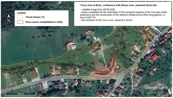
Figure 17.
Turcu River at the confluence with the Simon River, with works completed in 2020 for the restoration of the riverbed conveyance capacity and construction of flood defense infrastructure—tangent gabions with DNE 73.
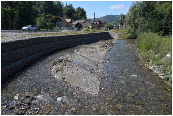
Figure 18.
Turcu River at the confluence with the Shimon River (23 August 2020)—reinforcement of the right bank with gabions arranged in three steps over a length of 50 m at DNE 73.
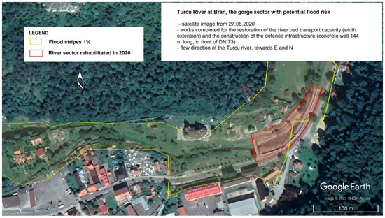
Figure 19.
Turcu River in the Bran Gorge sector—works completed to restore the river bed’s carrying capacity and to build flood defense infrastructure.
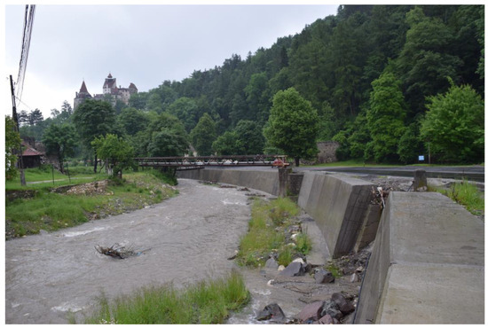
Figure 20.
Turcu River in the Bran gorge sector (19 June 2021)—bank reinforcement straight with concrete wall for 144 m in length in front of DNE 73.
The potential financial loss was calculated as the product of the length of the potentially affected road segments (km) and the cost of the rehabilitation works (RON/km). The total amount calculated (indicative and expressed as the value of the Romanian leu on the market on 15 November 2022) for the road segments potentially degraded (5.61094 km) by erosion exerted by the Turcu river at the overflow dictated by Q1% (230 m3/s at Tohanu Nou HS) is 16,683,956.37 lei, equivalent to 3,402,666.90 euro. This financial value is only part of the total amount that could be approved by the County Council of Brasov as an insurance fund for the restoration of public roads that may be affected in the flooding area of the Turcu River.
Bran, Moieciu de Jos, Cheia and Moieciu de Sus are part of an axis of intense traffic along the river and the Turcu valley, to and from places with tourist attraction and activity, belonging to the mountain sub-unit of the Bran–Dragoslavele Corridor. The only traffic route along the mentioned localities are the public roads DNE 73, DN 73F and DC 53, and the present study shows that the last two arteries have a major flood risk potential, materialized by a total of 4.95518 km of road segments possibly degraded by the mechanical action of water loaded with sediments when the Turcu River overflows.
5. Conclusions
The current research is an in-depth study at the local level, which focused on the floodplain of the Turcu River, a third-order tributary of the Danube River, partly included in the area of the Bran–Dragoslavele transcarpathian corridor. The present study contributes to the research, on the one hand, by completing the national hydrological database held by ANR and IHNGA. On the other hand, by producing hazard and flood risk maps, it has been possible to cover an area along an axis of particular tourist relevance. At the same time, the research area addressed in this study was not included in the maps published at a national level, which are accessible and viewable within the portal presented online by the A.N.A.R. We anticipate, however, that the overflow of the Turcu River at a Q1% flow of 230 m3/s, almost double compared to the historical maximum of 1975 (120 m3/s), could cause significant material damage under increasing anthropic pressure, visible in the increased concentration of buildings constructed in the 1% floodplain area in the last 30–40 years. Note that the effects of climate change have not been taken into account for the hydraulic modeling in the present research.
The natural flood hazard map, which was produced by defining the ranges of water depth values in the 1% floodplain, led, in a later stage, to the flood risk map, in which three risk classes (high, medium and low) were drawn up, to which the residual risk was added. Within the three classes, the potential financial loss (minimum values) to flooding was calculated for land and related real estate infrastructure (over 555 infrastructures identified on recent satellite images) that was located in the intra-urban or extra-urban areas of the localities crossed by the Turcu River and mapped in the 1% flood band. The risk was therefore perceived through an understanding of the concept of vulnerability of the courtyard land and the real estate infrastructure on their surface.
Concerning the vulnerability of the road infrastructure, we point out that the only road along Bran, Moieciu de Jos, Cheia and Moieciu de Sus are the public roads DNE 73, DN 73F and DC 53. The present study highlights the fact that the last two arteries have a major flood risk potential, materialized by a total of 4.95518 km of road segments that could be degraded by the mechanical action of water loaded with sediments, in case of the overflow of the Turcu river. The observations made on the flood risk map clearly highlight the segments vulnerable to the hydrological hazard that is inscribed on the intensely circulated tourist axis; with a particular tourist attractiveness, it is carried out between the mentioned localities along the Turcu valley.
The County Council of Brasov and the Local Councils could use the useful information from the current research, especially those contained in the cartographic materials, in order to draw up more precise intervention plans, useful for the County Inspectorate of Gendarmes “Nicolae Titulescu” Brasov, the County Committee of Brasov and the Local Committees organized for emergency situations. We believe that the intervention plans should be carried out thoroughly and rigorously, because observations from the current research show that in case of a severe flood disaster in the Turcu valley bed, the major problem related to the imminent temporary blocking of the only road communication route (DN 73F—for transport and supply) allowing the connection between the localities of Moieciu de Jos, Cheia and Moieciu de Sus and positioned linearly on the upper course of the studied valley, should be analyzed and solved.
The risk maps developed in this study can also support the planning–management activity for carrying out investment works for the prevention and combating of the effects of floods, which are the responsibility of the Brasov County Council. At the same time, these maps can be an important working tool for the realization of different local plans and strategies in fields such as: land use planning, urban planning, flood risk management, public information, etc.
In the future, the increase in spatial resolution, the accuracy of the 1% floodplain extent and the quality of detail of the hazard and risk maps can be improved by using DEMs obtained from leveling and the network of talus extracted from 1:5000 scale topographic maps, or DEMs obtained from scanning the targeted land surface using a drone-mounted LIDAR sensor.
Author Contributions
Conceptualization: Ș.B. and D.P.; methodology: Ș.B., S.R. and S.T.; software: S.T., I.F. and Ș.B.; validation: S.R., I.V. and I.F.; formal analysis: S.T. and D.P.; investigation: S.T. and S.R.; resources, S.T.; data curation: D.P., I.F. and I.V.; writing—original draft preparation: S.T. and Ș.B.; writing—review and editing, Ș.B., S.R. and D.P.; visualization, Ș.B. and D.P.; supervision, Ș.B.; project administration: D.P.; funding acquisition: S.R., I.V. and I.F. All authors contributed equally to this manuscript. All authors have read and agreed to the published version of the manuscript.
Funding
The present work has received financial support through the 2022–2023 Development Fund of the Babes, -Bolyai University.
Institutional Review Board Statement
Not applicable.
Informed Consent Statement
Not applicable.
Data Availability Statement
Not applicable.
Acknowledgments
All authors contributed equally to this manuscript that was chosen in consideration of the GIS community worldwide.
Conflicts of Interest
The authors declare no conflict of interest.
References
- Schneider, C.; Laize, C.L.R.; Acreman, M.C.; Flörke, M. How will climate change modify river flow regimes in Europe? Hydrol. Earth Syst. Sci. 2013, 17, 325–339. [Google Scholar] [CrossRef]
- Kundzewicz, Z.W.; Pinskwar, I.; Brakenridge, G.R. Large floods in Europe, 1985–2009. Hydrol. Sci. J. 2013, 58, 1–7. [Google Scholar] [CrossRef]
- Hall, J.; Arheimer, B.; Borga, M.; Brazdil, R.; Claps, P.; Kiss, A.; Kjeldsen, T.R.; Kriauciuniene, J.; Kundzewicz, Z.W.; Lang, M.; et al. Understanding flood regime changes in Europe: A state-of-the-art assessment. Hydrol. Earth Syst. Sci. 2014, 18, 2735–2772. [Google Scholar] [CrossRef]
- Alfieri, L.; Pappenberger, F.; Wetterhall, F.; Haiden, T.; Richardson, D.; Salamon, P. Evaluation of ensemble streamflow predictions in Europe. J. Hydrol. 2014, 517, 913–922. [Google Scholar] [CrossRef]
- Blöschl, G.; Hall, J.; Parajka, J.; Perdigão, R.A.P.; Merz, B.; Arheimer, B.; Aronica, G.T.; Bilibashi, A.; Bonacci, O.; Borga, M.; et al. Changing climate shifts timing of European floods. Science 2017, 357, 588–590. [Google Scholar] [CrossRef]
- Quirogaa, V.M.; Kurea, S.; Udoa, K.; Manoa, A. Application of 2D numerical simulation for the analysis of the February 2014 Bolivian Amazonia flood: Application of the new HEC-RAS version 5. Ribagua 2016, 3, 25–33. [Google Scholar] [CrossRef]
- Muszyński, R.; Kocur-Bera, K. Flood damage asses sment using river water levels-a case study of a town located in the North Mazovian Lowland (Poland). J. Ecol. Eng. 2021, 22, 200–212. [Google Scholar] [CrossRef]
- Castelli, F.; Galeotti, M.; Rabitti, G. Financial instruments for mitigation of flood risks: The case of Florence. Risk Anal. 2019, 39, 462–472. [Google Scholar] [CrossRef]
- Susnik, J.; Strehl, C.; Postmes, L.A.; Vamvakeridou-Lyroudia, L.S.; Malzer, H.J.; Savic, D.A.; Kapelan, Z. Assessing financial loss due to pluvial flooding and the efficacy of risk-reduction measures in the residential property sector. Water Resour. Manag. 2015, 29, 161–179. [Google Scholar] [CrossRef]
- European Environment Agency. Directive 2007/60/EC of the European Parliament and of the Council on the Assessment and Management of Flood Risks. Available online: https://www.eea.europa.eu/policy-documents/directive-2007-60-ec-of (accessed on 3 April 2022).
- Romanescu, G.; Stoleriu, C.C.; Mihu-Pintilie, A. Implementation of EU Water Framework Directive (2000/60/EC) in Romania-European Qualitative Requirements. In Water Resources Management in Romania; Negm, A., Romanescu, G., Zeleňáková, M., Eds.; Springer: Cham, Switzerland, 2020; pp. 17–55. [Google Scholar]
- Chendeș, V.; Rădulescu, D.; Rândașu, S.; Ion, B.; Achim, D.; Preda, A. Guidance for Reporting under the Floods Directive. Hidrotechnica 2014, 59, 10–11. [Google Scholar]
- Spachinger, K.; Dorner, W.; Metzka, R.; Serrhini, K.; Fuchs, S. Flood Risk and Flood Hazard Maps-Visualization of Hydrological Risks. IOP Conf. Ser. Earth Environ. Sci. 2008, 4, 012043. [Google Scholar] [CrossRef]
- Bures, L.; Roub, R.; Sychova, P.; Gdulova, K.; Doubalova, J. Comparison of bathymetric data sources used in hydraulic modeling of flood. J. Flood Risk Manag. 2019, 12, e12495. [Google Scholar] [CrossRef]
- Hu, D.; Lu, C.; Yao, S.; Yuan, S.; Zhu, Y.; Duan, C.; Liu, Y. A prediction-correction solver for real-time simulation of free-surface flow in river networks. Water 2019, 11, 2525. [Google Scholar] [CrossRef]
- Sosa, J.; Sampson, C.; Smith, A.; Neal, J.; Bates, P. A toolbox to quickly prepare flood inundation models for LISFLOOD-FP simulations. Environ. Model. Softw. 2020, 123, 104561. [Google Scholar] [CrossRef]
- Dey, S.; Saksena, S.; Merwade, V. Assessing the effect of different bathymetric models on hydraulic simulation of rivers in data sparse regions. J. Hydrol. 2019, 575, 838–851. [Google Scholar] [CrossRef]
- Wing, O.E.J.; Bates, P.D.; Neal, J.C.; Sampson, C.C.; Smith, A.M.; Quinn, N.; Shustikova, I.; Domeneghetti, A.; Gilles, D.W.; Goska, R.; et al. A New Automated Method for Improved Flood Defense Representation in Large-Scale Hydraulic Models. Water Resour. Res. 2019, 55, 11007–11034. [Google Scholar] [CrossRef]
- Papaioannou, G.; Varlas, G.; Terti, G.; Papadopoulos, A.; Loukas, A.; Panagopoulos, Y.; Dimitriou, E. Flood Inundation Mapping at Ungauged Basins Using Coupled Hydrometeorological-Hydraulic Modelling: The Catastrophic Case of the 2006 Flash Flood in Volos City, Greece. Water 2019, 11, 2328. [Google Scholar] [CrossRef]
- Arseni, M.; Rosu, A.; Calmuc, M.; Calmuc, V.A.; Iticescu, C.; Georgescu, L.P. Development of Flood Risk and Hazard Maps for the Lower Course of the Siret River, Romania. Sustainability 2020, 12, 6588. [Google Scholar] [CrossRef]
- Cole, S.J.; Moore, R.J.; Wells, S.C.; Mattingley, P.S. Real-time forecasts of flood hazard and impact: Some UK experiences. E3S Web Conf. 2016, 7, 18015. [Google Scholar] [CrossRef]
- Lo, S.W.; Wu, J.H.; Lin, F.P.; Hsu, C.H. Visual sensing for urban flood monitoring. Sensors 2015, 15, 20006–20029. [Google Scholar] [CrossRef] [PubMed]
- Murphy, A.T.; Gouldby, B.; Cole, S.J.; Moore, R.J.; Kendall, H. Real-time flood inundation forecasting and mapping for key railway infrastructure: A UK case study. E3S Web Conf. 2016, 7, 18020. [Google Scholar] [CrossRef]
- Arseni, M.; Roșu, A.; Bocăneală, C.; Constantin, D.-E.; Georgescu, P.L. Flood hazard monitoring using GIS and remote sensing observations. Carpathian J. Earth Environ. Sci. 2017, 12, 329–334. [Google Scholar]
- Domeneghetti, A.; Schumann, G.J.-P.; Tarpanelli, A. Preface: Remote Sensing for Flood Mapping and Monitoring of Flood Dynamics. Remote Sens. 2019, 11, 943. [Google Scholar] [CrossRef]
- Van Leeuwen, B.; Tobak, Z.; Kovács, F. Sentinel-1 and -2 Based near Real Time Inland Excess Water Mapping for Optimized Water Management. Sustainability 2020, 12, 2854. [Google Scholar] [CrossRef]
- Popa, M.C.; Peptenatu, D.; Draghici, C.C.; Diaconu, D.C. Flood Hazard Mapping Using the Flood and Flash-Flood Potential Index in the Buzău River Catchment, Romania. Water 2019, 11, 2116. [Google Scholar] [CrossRef]
- Popa, M.C.; Simion, A.G.; Peptenatu, D.; Dima, C.; Draghici, C.C.; Florescu, M.S.; Dobrea, C.R.; Diaconu, D.C. Spatial assessment of flash-flood vulnerability in the Moldova river catchment (N Romania) using the FFPI. J. Flood Risk Manag. 2020, 13, e12624. [Google Scholar] [CrossRef]
- Costache, R.; Pham, Q.B.; Sharifi, E.; Linh, N.T.T.; Abba, S.I.; Vojtek, M.; Vojteková, J.; Nhi, P.T.T.; Khoi, D.N. Flash-Flood Susceptibility Assessment Using Multi-Criteria Decision Making and Machine Learning Supported by Remote Sensing and GIS Techniques. Remote Sens. 2020, 12, 106. [Google Scholar] [CrossRef]
- ESRI, Resources, How Topo to Raster Works. Available online: https://pro.arcgis.com/en/pro-app/2.8/tool-reference/3d-analyst/how-topo-to-raster-works.htm (accessed on 10 April 2022).
- Huțanu, E.; Mihu-Pintilie, A.; Urzică, A.; Paveluc, L.E.; Stoleriu, C.C.; Grozavu, A. Using 1D HEC-RAS Modeling and LiDAR Data to Improve Flood Hazard Maps Accuracy: A Case Study from Jijia Floodplain (NE Romania). Water 2020, 12, 1624. [Google Scholar] [CrossRef]
- Kocsis, I.; Bilașco, Ș.; Irimuș, I.-A.; Dohotar, V.; Rusu, R.; Roșca, S. Flash Flood Vulnerability Mapping Based on FFPI Using GIS Spatial Analysis Case Study: Valea Rea Catchment Area, Romania. Sensors 2022, 22, 3573. [Google Scholar] [CrossRef] [PubMed]
- Bilasco, S.; Hognogi, G.G.; Roșca, S.; Pop, A.M.; Iuliu, V.; Fodorean, I.; Marian-Potra, A.C.; Sestras, P. Flash Flood Risk Assessment and Mitigation in Digital-Era Governance Using Unmanned Aerial Vehicle and GIS Spatial Analyses Case Study: Small River Basins. Remote Sens. 2022, 14, 2481. [Google Scholar] [CrossRef]
- US Army Corps of Engineers Institute for Water Resources Hydrologic Engineering Center. HEC-RAS for Windows. Available online: https://www.hec.usace.army.mil/software/hec-ras/download.aspx (accessed on 16 April 2022).
- Patel, D.P.; Ramirez, J.A.; Srivastava, P.K.; Bray, M.; Han, D. Assessment of flood inundation mapping of Surat city by coupled 1D/2D hydrodynamic modeling: A case application of the new HEC-RAS 5. Nat. Hazards 2017, 89, 93–130. [Google Scholar] [CrossRef]
- Huțanu, E.; Urzica, A.; Paveluc, L.E.; Stoleriu, C.C.; Grozavu, A. Comparative analysis of flooded areas using satellite images Landsat 7-ETM+ and hydraulic model HEC-RAS. Case study: The Jijia River, Slobozia-Dângeni section. In Proceedings of the 5th International Scientific Conference Geobalcanica, Sofia, Bulgaria, 13–14 June 2019; Volume 5, pp. 619–625. [Google Scholar]
- Song, Y.; Park, Y.; Lee, J.; Park, M.; Song, Y. Flood forecasting and warning system structures: Procedure and application to a small urban stream in South Korea. Water 2019, 11, 1571. [Google Scholar] [CrossRef]
- Enea, A.; Urzica, A.; Breabăn, I.G. Remote sensing, GIS and HEC-RAS techniques, applied for flood extent validation, based on Landsat imagery, LiDAR and hydrological data. Case study: Baseu River, Romania. J. Environ. Prot. Ecol. 2018, 19, 1091–1101. [Google Scholar]
- Reil, C.; Skoulikaris, T.A.; Roub, R. Evaluation of riverbed representation methods for one-dimensional flood hydraulics model. J. Flood Risk Manag. 2018, 11, 169–179. [Google Scholar] [CrossRef]
- Liu, Z.; Merwade, V.; Jafarzadegan, K. Investigating the role of model structure and surface roughness ingenerating flood inundation extents using one- and two-dimensional hydraulic models. J. Flood Risk Manag. 2019, 12, e12347. [Google Scholar] [CrossRef]
- Ghimire, E.; Sharma, S. Flood Damage Assessment in HAZUS Using Various Resolution of Data and One-Dimensional and Two-Dimensional HEC-RAS Depth Grids. Nat. Hazards Rev. 2021, 22, 04020054. [Google Scholar] [CrossRef]
- Pinos, J.; Timbe, L. Performance assessment of two-dimensional hydraulic models for generation of flood inundation maps in mountain river basins. Water Sci. Eng. 2019, 12, 11–18. [Google Scholar] [CrossRef]
- Pasquier, U.; He, Y.; Hooton, S.; Goulden, M.; Hiscock, K.M. An integrated 1D-2D hydraulic modelling approach to assess the sensitivity of a coastal region to compound flooding hazard under climate change. Nat. Hazards 2019, 98, 915–937. [Google Scholar] [CrossRef]
- Papaioannou, G.; Loukas, A.; Vasiliades, L.; Aronica, G.T. Flood inundation mapping sensitivity to riverine spatial resolution and modelling approach. Nat. Hazards 2016, 83, 117–132. [Google Scholar] [CrossRef]
- Martínez-Graña, A.M.; Gago, C. Environmental analysis of flood risk in urban planning: A case study in Las Quemadillas, Cordoba, Spain. Environ. Eng. Manag. J. 2018, 17, 2527–2536. [Google Scholar] [CrossRef]
- US Army Corps of Engineers Institute for Water Resources Hydrologic Engineering Center. HEC-RAS River Analysis System Hydraulic Reference Manual Version 5.0. 2016. Available online: https://www.hec.usace.army.mil/software/hec-ras/documentation/HEC-RAS%205.0%20Reference%20Manual.pdf (accessed on 27 July 2021).
- GD, no. 1309 of 27 October 2005 on the Approval of the Programme for the Implementation of the National Plan for the Prevention, Protection and Mitigation of Floods and Its Financing (Updated until 6 January 2015). Available online: http://legislatie.just.ro/Public/DetaliiDocument/65610 (accessed on 8 April 2022).
- Plan for the Prevention, Protection and Mitigation of Floods in the Olt River Basin. Available online: http://arhiva.rowater.ro/daolt/Proiecte/PPPDI%2001.06.2011.pdf (accessed on 2 April 2022).
- Rădulescu, D.; Chendeș, V.; Ion, M.B. Hazard and Risk Maps in Romania, according to the Requirements of Directive 2007/60/EC. J. Rom. Assoc. Hydrol. Sci. Viitura 2014. Available online: https://www.researchgate.net/publication/283085982 (accessed on 7 April 2022).
- Flood Risk Management Plan, National Synthesis. Available online: http://www.mmediu.ro/app/webroot/uploads/files/2016-04-26_PMRI_Sinteza_Nationala.pdf (accessed on 9 April 2022).
- National Administration “Romanian Waters”, Hazard and Flood Risk Maps. Available online: https://rowater.ro/despre-noi/descrierea-activitatii/managementul-situatiilor-de-urgenta/directiva-inundatii-2007-60-ce/harti-de%20hazard-si-risc-la-inundatii/ (accessed on 24 August 2021).
- Flood Risk Management Plan, Olt Water Basin Administration. Available online: https://rowater.ro/wp-content/uploads/2020/11/6-PMRI-Olt.pdf (accessed on 7 April 2022).
- Balasco, S.; Horváth, C. Digital Mapping of Floodplains Based on Statistics, Hydraulic Calculations and GIS Spatial Analysis; Casa Cărții de Știință: Cluj-Napoca, Romania, 2016; 168p. [Google Scholar]
- Haidu, I. Frequency analysis and quantitative risk assessment. In Risks and Disasters; Casa Cărții de Știință: Cluj-Napoca, Romania, 2002; pp. 180–207. [Google Scholar]
- Ntanganedzeni, B.; Nobert, J. Flood risk in Luvuvhu River, Limpopo Province, South Africa. Phys. Chem. Earth 2020, 124, 102959. [Google Scholar] [CrossRef]
- Defence Plan Brasov County, County Plans for the Olt River Basin. Available online: http://arhiva.rowater.ro/daolt/Planuri%20judetene%20aferente%20bazinului%20hidrografic%20Ol/Forms/AllItems.aspx (accessed on 7 April 2022).
- Ministry of National Defence, Military Topographic Directorate, Bucharest, Topographic Maps 1:25,000. Available online: https://portal.geomil.ro/portal/home/webmap/viewer.html?webmap=f4ff7adb4477470ea525061079ec972d (accessed on 7 April 2022).
- Manning, R. On the flow of water in open channels and pipes. Trans. Inst. Civ. Eng. Irel. 1891, 20, 161–207. [Google Scholar]
- Google Earth Pro GIS Application. Available online: https://www.google.com/intl/ro/earth/versions/#earth-pro (accessed on 5 April 2022).
- Google Maps GIS Application. Available online: https://www.google.ro/maps/ (accessed on 8 April 2022).
- Chamber of Notaries Public Brasov, Market Study on Minimum Values of Real Estate Properties in Brasov and Covasna Counties. Available online: http://www.unnpr.ro/files/expertize2021/CNPBrasov/bv_si_cv_2021.pdf (accessed on 1 April 2022).
- Modernization Works of the Intercounty Road DJ 104A, DJ 105C, DJ 105P, County. Brașov, Romania. Available online: http://litera9.com/foto-podurile-de-pe-traseul-drumului-interjudetean-dj-104a-dj-105c-dj-105p-sunt-in-lucru-lucrarile-fac-parte-din-proiectul-de-modernizare-a-drumului-de-sub-munte/ (accessed on 22 May 2021).
- Chow, V.T. Open-Channel Hydraulics; McGraw-Hill: New York, NY, USA, 1959. [Google Scholar]
- Mtamba, J.; van der Velde, R.; Ndomba, P.; Zoltán, V.; Mtalo, F. Use of Radarsat-2 and Landsat TM Images for Spatial Parameterization of Manning’s Roughness Coefficient in Hydraulic Modeling. Remote Sens. 2015, 7, 836–864. [Google Scholar] [CrossRef]
- Bricker, J.D.; Gibson, S.; Takagi, H.; Imamura, F. On the need for larger Manning’s roughness coefficients in depth-integrated tsunami inundation models. Coast. Eng. J. 2015, 57, 1550005-1–1550005-13. [Google Scholar] [CrossRef]
- Romanian National Institute of Geology, Geological map of R. S. Romania, scale: 1:50,000, map sheet 110 d Moeciu L-35-87-D (1971), 110 b Zărnești L-35-87-B (1972), accessed from the Secret Documents Office of the Faculty of Geography of “Babes-Bolyai” Cluj-Napoca University.
- Water Law No 107 of 25 September 1996. Available online: https://legislatie.just.ro/Public/DetaliiDocument/8565 (accessed on 1 April 2022).
- Natural Disaster Insurance Pool, Romania, Natural Disaster Insurance Policy. Available online: https://www.paidromania.ro/ce-este-pad/ (accessed on 26 August 2021).
- Law No 260 of 4 November 2008 on Compulsory Insurance of Dwellings against Earthquakes, Landslides and Floods. Available online: https://legislatie.just.ro/Public/DetaliiDocumentAfis/126184 (accessed on 5 April 2022).
- National Institute of Statistics, Romania, Stable Population by Counties, Municipalities, Cities and Component Localities at RPL_2011. Available online: http://www.recensamantromania.ro/rezultate-2/ (accessed on 27 August 2021).
- Bilașco, Ș.; Roșca, S.; Vescan, I.; Fodorean, I.; Dohotar, V.; Sestras, P. A GIS-Based Spatial Analysis Model Approach for Identification of Optimal Hydrotechnical Solutions for Gully Erosion Stabilization. Case Study. Appl. Sci. 2021, 11, 4847. [Google Scholar] [CrossRef]
- Costea, A.; Bilasco, S.; Irimus, I.-A.; Rosca, S.; Vescan, I.; Fodorean, I.; Sestras, P. Evaluation of the Risk Induced by Soil Erosion on Land Use. Case Study: Guruslău Depression. Sustainability 2022, 14, 652. [Google Scholar] [CrossRef]
- Sestras, P.; Bilașco, Ș.; Roșca, S.; Veres, I.; Ilies, N.; Hysa, A.; Spalević, V.; Cîmpeanu, S.M. Multi-Instrumental Approach to Slope Failure Monitoring in a Landslide Susceptible Newly Built-Up Area: Topo-Geodetic Survey, UAV 3D Modelling and Ground-Penetrating Radar. Remote Sens. 2022, 14, 5822. [Google Scholar] [CrossRef]
Disclaimer/Publisher’s Note: The statements, opinions and data contained in all publications are solely those of the individual author(s) and contributor(s) and not of MDPI and/or the editor(s). MDPI and/or the editor(s) disclaim responsibility for any injury to people or property resulting from any ideas, methods, instructions or products referred to in the content. |
© 2023 by the authors. Licensee MDPI, Basel, Switzerland. This article is an open access article distributed under the terms and conditions of the Creative Commons Attribution (CC BY) license (https://creativecommons.org/licenses/by/4.0/).