Abstract
This paper presents rain attenuation effects on the performance of the full-duplex link in a tropical region based on one-year measurement data at 73.5- and 83.5-GHz E-band for distances of 1.8 km (longer links) and 300 m (shorter links). The measured rain attenuations were analyzed for four links, and the throughput degradation due to rain was investigated. The findings from this work showed that the rain attenuation for both frequencies (73.5 and 83.5 GHz) of E-band links are the same. The rain rates above 108 and 193 mm/h caused an outage for the longer and shorter links, respectively. The 73.5 and 83.5 GHz bands can support the full-duplex wireless back-haul link under rainy conditions with outage probability of and for the longer and shorter links, respectively. This work also finds that the heavy rain with rain rates above 80 mm/h for long link and 110 mm/h for short link causes about 94% and 0.90% degradation of maximum throughput. The application of these findings would help improve the architecture and service of full-duplex wireless E-band links that are established at other sites and in other tropical areas.
Keywords:
E-band; wireless back-haul; 73 GHz; 83 GHz; rain attenuation; outage probability; tropical region 1. Introduction
For ultra-high capacity point-to-point communications, the 71–76 and 81–86 GHz bands (mostly known as the “E-band”) are worldwide licensed, and are capable of up to 5-GHz full-duplex bidirectional transmission. E-band wireless systems offer full-duplex Gigabit Ethernet connection at 1 Gbps and above rates in economic radio architectures with carrier-class availability within mile distances and beyond [1]. The role of radio channel propagation conditions is very important to meet the high availability requirements in wireless back-haul networks. The rain attenuation for millimeter-wave, especially E-band, is one of the most important factors to consider for achieving quality requirements in terms of throughput and outage. The ITU-R models [2,3,4,5] for rain attenuation have been used to ensure the planned radio links meet the quality requirements. These models for conventional microwave bands are well examined in different temporal and tropical regions around the world [6,7,8,9], however, there are less empirical data for the E-band.
At the E-band, only a few studies have investigated the rain attenuation [10,11,12,13,14,15,16,17,18]. Based on a one-year measurement data in United Kingdom (UK) at 25.84 and 77.52 GHz [10] and over a short measurement period at 77 and 300 GHz [11], the rainfall rate statistics and rain attenuation were examined. In [13], based on ten months measurements at the 73.5 GHz band, the impact of rain on signal attenuation was analyzed and modeled along a 1-km terrestrial link in Molndal, Sweden. In Madrid, Spain, the measurements at 75 and 85 GHz bands were conducted over two years along an 840-m link to analyze and model the rain impact on signal attenuation [14]. The accuracy of the ITU-R P. 530-16 model [5] was examined based on the three years of experimental data at 75 GHz in South Korea along a 3.2-km link [15]. In Malaysia, the rainfall rate statistics and rain attenuation were investigated based on a one-year measurement data at 21.8 and 73.5 GHz in [17,18]. Most studies for rain attenuation at E-band were presented and compared in [17].
Among the previous studies at E-band, none of them were investigated the rain effects on the performance of a full-duplex link using 70/80 GHz bands. This work is the only measurement campaign conducted in tropical region, to study the precipitation effects on the performance of full-duplex link using 73.5 GHz and 83.5 GHz E-band along 1.8 km and 300 m line-of-sight (LOS) wireless back-haul links. In this paper, the statistical analysis results of one year of rain attenuation at 73.5 GHz and 83.5 GHz E-band in Malaysia are presented. The performance of full-duplex E-band wireless back-haul link along 1.8-km and 300-m distances is investigated based on the one-year outage probability under rain effects.
2. Measurement Setup
The E-Band transceivers for this measurement campaign are the Mini Link ML-6352 manufactured by Ericsson, specification details can be found in [19]. To study the rain effects on full-duplex wireless back-haul link, the 73.5 and 83.5 GHz E-band links were launched in September 2018. The links used a bandwidth of 750 MHz and adaptive modulation of up to 256 QAM and 32 QAM which supports up to 4.532 Gbps and 2.832 Gbps along a 1.8-km and 300-m path length, respectively. The link parameters including site, directional antenna specification, and link budgets parameters are listed in Table 1. The antennas were covered with acrylonitrile styrene acrylate (ASA) radomes to reduce the wet antenna effects. A complete test of the antennas and the calculation of their specifications were conducted after the dielectric coating was applied and has been shown to fulfill the ETSI radiation pattern envelope (RPE) class 4 [20]. The received signal power was recorded using the built-in data logger in the Ericsson E-Band Mini Link equipment with accuracy of 0.1 dBm. The maximum and minimum received signal level (RSL) values were provided every 15 min using the data logger of the ML-6352 at the Rx. To provide the 1.8-km and 300-m E-band links, the transceivers are located in three different sites—Site A, B, and C—as shown in Figure 1. The stations’ names and geographic coordinates are provided in Table 1. Based on the measurement setup and configurations, there are four E-band links that support full-duplex wireless back-haul: the 73.5-GHz 1.8-km link from Site A to Site B (A-B link), the 83.5-GHz 1.8-km link from Site B to Site A (B-A link), the 73.5-GHz 300-m link from Site C to Site B (C-B link), and the 83.5-GHz 300-m link from Site B to Site C (B-C link).

Table 1.
Parameters of experimental E-band links.
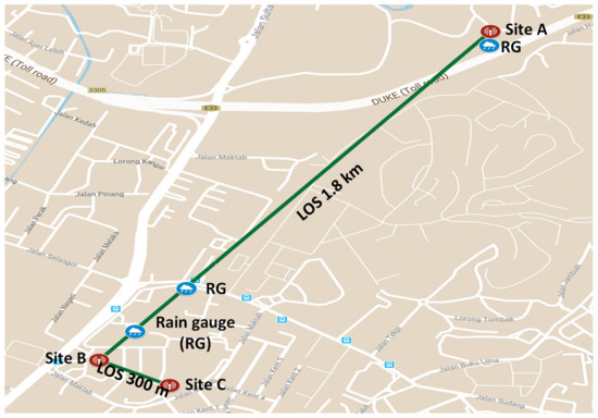
Figure 1.
Measurement links map in Kuala Lumpur, Malaysia for 1.8-km and 300-m line-of-sight (LOS) path at 73.5 and 83.5 GHz E-bands between Kolej Siswa Jaya (Site A) and Menara Razak, Universiti Teknologi Malaysia (Site B); and 300-m LOS path at E-band between Site B and Residensi UTM (Site C).
Considering the spatial inhomogeneity of rain rate, the rain distribution is not uniform along the link, especially for the 1.8-km path length. We used three rain gauges along the path of 1.8 km to collect the rainfall intensity every minute, two rain gauges were installed at Site B and Site C, and the third one was installed at Site A, as shown in Figure 1. The data-logging rain gauge system is battery powered and includes data logger with a tipping-bucket rain gauge of 0.2-mm sensitivity, and the rain gauge specifications are given in [21]. The rain gauges record the rainfall that occurs every minute—i.e., at an integral multiple of 12 mm/h—and the average rain rate throughout the link was calculated using the inverse distance weighting (IDW) method [17,22]. IDW has been effectively utilized as one of the standard spatial interpolation procedures [23,24]. In IDW, the estimated value is a weighted sum of the rain gauge values given by
where is number of rain gauges. The weight of each rain gauge value on the estimated location E depends on the distance in between, and is given by [25,26]
From these estimated values, the average rain rate was determined and used in this analysis.
Figure 2 presents the cumulative distribution function (CDF) of the measured rain rate for every minute along a one-year period together with the ITU-R PN.837-1 model [27]. The experimental CDF is also compared with the CDF of rainfall 1-h integration time data collected from the Malaysian Meteorological Station (MMS) over a 12-year period [28]. Chebil and Rahman’s model [28] was used to convert these rain-rate data to the equivalent 1-min integration time. Finally, the measured CDF in the link area is also compared with the CDF of l-minute rainfall data measured over three years (June 1992 to May 1995) in Kuala Lumpur, Malaysia (308 N, 10139 E) using a tipping bucket rain gauge of 0.5 mm per tip [28]. It can be shown that the CDF of measured rain rate is very close to the ITU-R, MMS, and Chebil for any rain rates below 150 mm/h. The largest deviation between the CDF of the measured rain rate and the ITU-R model appears at low percentage of time (0.001%) with around 60 mm/h difference. However, the difference between the CDF of our measurements and the other measurement results—namely, MMS and Chebil—remains small (12 mm/h) even at these low percentages of time (0.001%).
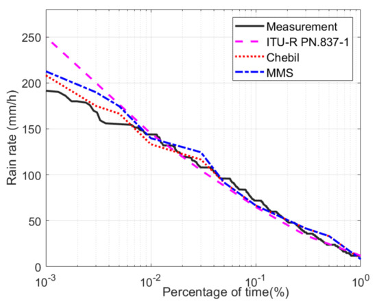
Figure 2.
Cumulative distribution for maximum rain rate every minute for one year.
3. Rain Attenuation
The difference between the minimum RSL under clear sky conditions and the minimum RSL under rainy conditions was used to calculate the rain attenuation. The difference between the RSL in the clear sky condition period and the RSL during the first hour after the rainfall has stopped represents the average wet antenna’s radomes effect. It was calculated to be 1.5 dB and excluded from rain attenuation [18]. The cumulative distribution functions (CDFs) for the maximum attenuation and maximum rainfall every 15 min in the 1.8-km 73.5- and 83.5-GHz LOS terrestrial link is shown in Figure 3. It shows that the rain attenuations are almost the same for both 73.5-GHz and 83.5-GHz E-Band links at all time of percentages. The maximum rain attenuation for both links is 40.10 dB at 0.03% of time. Our results agree with previous studies showing dominant and constant rain losses for microwave link with operating frequencies at 70 and 80 GHz bands [29,30]. From the rain-rate curve in this figure, it is worth noticing that for any rain rate above 108 mm/h, both links are down. It means that the two links can support the full-duplex transmission under rainy conditions with the outage probability of .
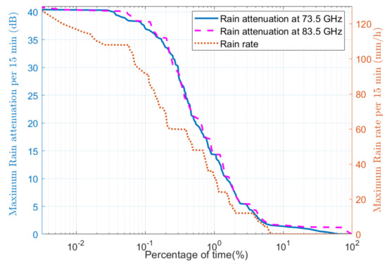
Figure 3.
Cumulative distribution for maximum rain attenuation along 1.8-km LOS links.
The CDFs for the maximum attenuation and maximum rainfall every 15 min in the 300-m 73.5 and 83.5 GHz LOS terrestrial link is shown in Figure 4. It shows that the rain attenuation is almost the same for both E-band links at all time of percentage. The maximum rain attenuation for both links is 25.00 dB at 0.006% of time. From the rain-rate curve in Figure 4, it is worth noticing that for any rain rate above 193 mm/h, both links are down. It means that the two links can support the full-duplex transmission under rainy conditions with the outage probability of .
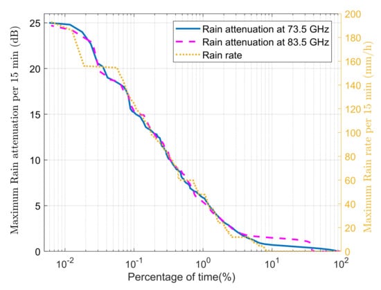
Figure 4.
Cumulative distribution for maximum rain attenuation along 300-m LOS links.
4. Performance Analysis
Each wireless back-haul link—either the one with the long path of 1.8 km or the short path of 300 m—can support up to 4.5 Gbps and 2.8 Gbps using 256-QAM and 32-QAM modulations under clear sky and light rain conditions. To maintain the link availability during heavy rain, the total throughput was sacrificed by reducing the number of transmission bits by applying the adaptive modulation technique. Detailed analysis for utilization of adaptive modulation modes along 1.8-km and 300-m links are shown in Figure 5 and Figure 6. Figure 5 shows that at 98% of time, the 1.8-km link is available using high-order modulation of 256 QAM to support the maximum throughput of 4.5 Gbps for the link. For short link of 300 m, Figure 6 shows that the link is available at 98.83% of time with 32 QAM (representing the highest order modulation for short link based on the link setup) to support the maximum throughput of 2.8 Gbps for the link. As both links of 73.5 and 83.5 GHz have the same performance of rain attenuation either in long distance (1.8 km) or short distance (300 m), the measured throughput represents the full-duplex wireless back-haul link.
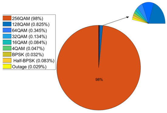
Figure 5.
Adaptive modulation modes for full-duplex wireless back-haul E-band link along 1.8 km.
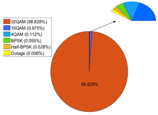
Figure 6.
Adaptive modulation modes for full-duplex wireless back-haul E-band link along 300 m.
Figure 7 and Figure 8 present the measured throughput in the full-duplex E-bands links with different rain rate for long (1.8 km) and short (300 m) links, respectively. From visual inspection of the figures, it can be noted that the throughput degrades with increasing rain rate. It can be shown that the maximum throughput of 4.5 Gbps and 2.8 Gbps can be achieved at any rain rate below 5 mm/h and 10 mm/h along 1.8 km and 300 m, respectively. For the long link of 1.8-km LOS path, Figure 7 shows that the rain rates above 5 mm/h and below 32 mm/h degrade the throughput by 1 Gbps. For heavy rain rates above 80 mm/h, the throughput is around 283.2 Mbps, which is dramatically degradation compared to low rain rates below 20 mm/h. For short link of 300 m LOS path, Figure 8 shows that the rain rates above 10 mm/h and below 50 mm/h degrade the throughput by 0.6 Gbps. For heavy rain rates above 110 mm/h, the throughput is around 283.2 Mbps, which is dramatically degraded compared to low rain rates below 65 mm/h.
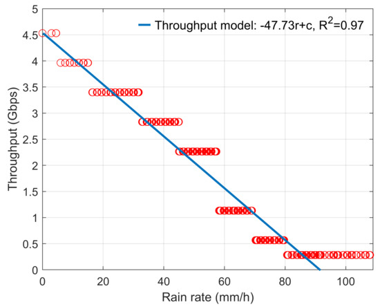
Figure 7.
Variation of throughput with rain rate at full-duplex wireless back-haul E-band link along 1.8 km.
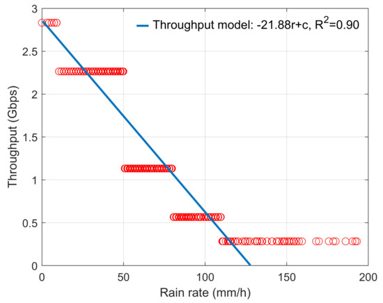
Figure 8.
Variation of throughput with rain rate at full-duplex wireless back-haul E-band link along 300 m.
If we define the rain rate as variable r and maximum throughput as constant c, the measured throughput degradation with rain rate can be modeled as
The sum square errors of (3) are found to be 0.9753 and 0.8993 for 1.8 km and 300 m, respectively.
5. Conclusions
In this paper, the rain effects on the performance of a full-duplex E-band link is investigated based on measurement campaign done in Malaysia. The CDF of rain attenuation at 73.5- and 83.5-GHz E-band links were calculated for longer (1.8 km) and shorter (300 m) LOS paths. The maximum rain attenuation for full-duplex links are 40.1 dB and 25 dB for 1.8 km and 300 m at the rain rates of 108 and 193 mm/h, respectively. The rain rates above 108 and 193 mm/h cause an outage of full-duplex links with outage probabilities are and for longer and shorter links, respectively. The throughput degradation for full-duplex link with rain rate was presented. The E-band link with low rain rate below 5 mm/h along 1.8 km and 10 mm/h along 300 m can support up to 4.5 Gbps for long link and 2.8 Gbps for short link; while for heavy rain above 80 mm/h (at 1.8 km distance) and 110 mm/h (at 300 m distance), the throughput degrades to 283.2 Mbps. Applying these findings would help to enhance the architecture and service of full-duplex wireless back-haul E-band connections that will be formed at other related sites as well as in other tropical regions.
Author Contributions
Conceptualization, A.A.-S. and M.H.A.; data curation, A.A.-S. and M.C.; formal analysis, A.A.-S., M.M., M.C., M.H.A., and T.A.R.; funding acquisition, A.A.-S., M.C., and M.H.A.; investigation, A.A.-S., M.M., M.C., M.H.A., and T.A.R.; methodology, A.A.-S. and M.M.; project administration, A.A.-S., M.C., and M.H.A.; resources, A.A.-S., M.M., and M.H.A.; software, A.A.-S. and M.M.; supervision, M.C. and M.H.A.; validation, M.M., M.C., M.H.A., and T.A.R.; visualization, M.M., M.C., and T.A.R.; writing—review and editing, M.M., M.C., and T.A.R. All authors have read and agreed to the published version of the manuscript.
Funding
This work was supported by Universiti Teknologi Malaysia (UTM) under HICOE Grant R.J130000.7851.4J413, and by MOHE through FRGS-UTM Grant R.J130000.7851.5F177. It was also supported by Manu Lab, NTNU, Gjøvik.
Conflicts of Interest
The authors declare no conflict of interest.
References
- Wang, L.; Cheng, Y.J.; Ma, D.; Weng, C.X. Wideband and dual-band high-gain substrate integrated antenna array for E-band multi-gigahertz capacity wireless communication systems. IEEE Trans. Antennas Propag. 2014, 62, 4602–4611. [Google Scholar] [CrossRef]
- Series, R.P. Propagation data and prediction methods required for the design of terrestrial line-of-sight systems. In Recommendation ITU-R P. 530–12; ITU: Geneva, Switzerland, 2006; pp. 1–47. [Google Scholar]
- Series, R.P. Propagation data and prediction methods required for the design of terrestrial line-of-sight systems. In Recommendation ITU-R P. 530–14; ITU: Geneva, Switzerland, 2012; pp. 1–51. [Google Scholar]
- Series, R.P. Propagation data and prediction methods required for the design of terrestrial line-of-sight systems. In Recommendation ITU-R P. 530–15; ITU: Geneva, Switzerland, 2013; pp. 1–51. [Google Scholar]
- Series, R.P. Propagation data and prediction methods required for the design of terrestrial line-of-sight systems. In Recommendation ITU-R P. 530–16; ITU: Geneva, Switzerland, 2015; pp. 1–56. [Google Scholar]
- Mello, L.D.S.; Pontes, M.; De Souza, R.; Garcia, N.P. Prediction of rain attenuation in terrestrial links using full rainfall rate distribution. Electron. Lett. 2007, 43, 1442–1443. [Google Scholar] [CrossRef]
- Islam, R.M.; Abdulrahman, Y.A.; Rahman, T.A. An improved ITU-R rain attenuation prediction model over terrestrial microwave links in tropical region. EURASIP J. Wirel. Commun. Netw. 2012, 2012, 189. [Google Scholar] [CrossRef][Green Version]
- Thorvaldsen, P.; Henne, I. Outdoor transmission measurement at 26 GHz: Results of a 4 year trial in Prague. Radio Sci. 2016, 51, 402–410. [Google Scholar] [CrossRef]
- Shrestha, S.; Choi, D.Y. Rain attenuation over terrestrial microwave links in South Korea. IET Microw. Antennas Propag. 2017, 11, 1031–1039. [Google Scholar] [CrossRef]
- Huang, J.; Cao, Y.; Raimundo, X.; Cheema, A.; Salous, S. Rain Statistics Investigation and Rain Attenuation Modeling for Millimeter Wave Short-Range Fixed Links. IEEE Access 2019, 7, 156110–156120. [Google Scholar] [CrossRef]
- Norouzian, F.; Marchetti, E.; Gashinova, M.; Hoare, E.; Constantinou, C.; Gardner, P.; Cherniakov, M. Rain attenuation at millimetre wave and low-THz frequencies. IEEE Trans. Antennas Propag. 2019, 68, 421–431. [Google Scholar] [CrossRef]
- Lewark, U.J.; Mahler, T.; Antes, J.; Boes, F.; Tessmann, A.; Henneberger, R.; Kallfass, I.; Zwick, T. Experimental validation of heavy rain attenuation in E-band based on climate wind tunnel measurements at 77 GHz. CEAS Space J. 2015, 7, 475–481. [Google Scholar] [CrossRef]
- Hansryd, J.; Li, Y.; Chen, J.; Ligander, P. Long term path attenuation measurement of the 71–76 GHz band in a 70/80 GHz microwave link. In Proceedings of the Fourth European Conference on Antennas and Propagation, Barcelona, Spain, 12–16 April 2010; IEEE: Piscataway, NJ, USA, 2010; pp. 1–4. [Google Scholar]
- García-Rubia, J.M.; Riera, J.M.; Garcia-del Pino, P.; Benarroch, A. Attenuation measurements and propagation modeling in the W-band. IEEE Trans. Antennas Propag. 2012, 61, 1860–1867. [Google Scholar] [CrossRef]
- Shrestha, S.; Choi, D.Y. Rain attenuation statistics over millimeter wave bands in South Korea. J. Atmos. Solar-Terr. Phys. 2017, 152, 1–10. [Google Scholar] [CrossRef]
- Hong, E.S.; Lane, S.; Murrell, D.; Tarasenko, N.; Christodoulou, C.; Keeley, J. Estimating Rain Attenuation at 72 and 84 GHz From Raindrop Size Distribution Measurements in Albuquerque, NM, USA. IEEE Geosci. Remote Sens. Lett. 2019. [Google Scholar] [CrossRef]
- Al-Saman, A.M.; Cheffena, M.; Mohamed, M.; Azmi, M.H.; Ai, Y. Statistical Analysis of Rain at Millimeter Waves in Tropical Area. IEEE Access 2020, 8, 51044–51061. [Google Scholar] [CrossRef]
- Al-Saman, A.; Mohamed, M.; Ai, Y.; Cheffena, M.; Azmi, M.H.; Rahman, T.A. Rain Attenuation Measurements and Analysis at 73 GHz E-Band Link in Tropical Region. IEEE Commun. Lett. 2020. [Google Scholar] [CrossRef]
- ERICSSON. Link Specifications. 2015. Available online: https://tele-a.ru/wp-content/uploads/2015/09/6352-DS.pdf (accessed on 28 August 2020).
- ERICSSON. Microwave Antennas. 2019. Available online: http://storage.mtender.gov.md/get/f7291f5a-ceb2-4ed0-a95d-d47694abcbe0-1570511924257 (accessed on 28 August 2020).
- Gauge, H.R. Rainfall Data Logging System. 2018. Available online: https://www.onsetcomp.com/files/data-sheet/Onset%20HOBO%20RG3%20Rain%20Gauge.pdf (accessed on 28 August 2020).
- Chen, F.W.; Liu, C.W. Estimation of the spatial rainfall distribution using inverse distance weighting (IDW) in the middle of Taiwan. Paddy Water Environ. 2012, 10, 209–222. [Google Scholar] [CrossRef]
- Longley, P.; Goodchild, M.; Maguire, D.; Rhind, D. Geographic Information Systems and Science; John Wiley & Sons: New York, NY, USA, 2001; pp. 150–151. [Google Scholar]
- Burrough, P.A.; McDonnell, R.; McDonnell, R.A.; Lloyd, C.D. Principles of Geographical Information Systems; Oxford University Press: Oxford, UK, 2015. [Google Scholar]
- Zhu, H.; Jia, S. Uncertainty in the spatial interpolation of rainfall data. Prog. Geogr. 2004, 23, 34–42. [Google Scholar]
- Lin, X.; Yu, Q. Study on the spatial interpolation of agroclimatic resources in Chongqing. J. Anhui Agric. Sci. 2008, 36, 13431–13463. [Google Scholar]
- Series, R.P. Characteristics of precipitation for propagation modelling. In RECOMMENDATION ITU-R PN.837-1; ITU: Geneva, Switzerland, 1994; pp. 1–4. [Google Scholar]
- Chebil, J.; Rahman, T. Rain rate statistical conversion for the prediction of rain attenuation in Malaysia. Electron. Lett. 1999, 35, 1019–1021. [Google Scholar] [CrossRef]
- Hilt, A. Availability and Fade Margin Calculations for 5G Microwave and Millimeter-Wave Anyhaul Links. Appl. Sci. 2019, 9, 5240. [Google Scholar] [CrossRef]
- Coldrey, M.; Allasia, A.; Bao, L.; Boch, E.; Ferrari, G.; Gentina, D.; Putkonen, J.; Sutton, A.; Yigal, L.; Zein, N. Maturity and field proven experience of millimetre wave transmission. In ETSI White Paper; ETSI: Sophia Antipolis, France, 2015; Volume 10. [Google Scholar]
© 2020 by the authors. Licensee MDPI, Basel, Switzerland. This article is an open access article distributed under the terms and conditions of the Creative Commons Attribution (CC BY) license (http://creativecommons.org/licenses/by/4.0/).