Abstract
Tabular Middle Atlas of Morocco holds the main water reservoir that serves many cities across Morocco. Dolomite and limestone are the most dominant geologic formations in this region in which water resources are contained. The recent studies conducted to evaluate the quality of this water suggest that it is very vulnerable to pollutants resulting from both anthropogenic and natural phenomenon. High and very high-resolution satellite imagery have been used in an attempt to gain a better understanding of this karstic system and suggest a strategy for its protection in order to reduce the impact of these phenomenon. Based on the surface reflectance of land cover benchmarks, the karstic system has been horizontally delineated, as well as regions with intense human activities. Using band combination in the portion of the infrared, shortwave infrared, and visible parts of the electromagnetic spectrum, we identified bare lands which have been interpreted as carbonate rocks, clay minerals, uncultivated fields, basalts rocks, and built-up areas. Other classes such as water and vegetation have been identified. Carbonate rocks have been identified as areas with a high rate of water infiltration through their fracture system. Using a Sobel operator filter, these fractures have been mapped and their results have revealed new and existing faults in two major fracture directions, NE-SW and NW-SE, where NE-SW is the preferable pathway for surface water infiltration towards the groundwater reservoir, while the NW-SE direction drains groundwater from the Cause to the basin of Saiss. Over time, the infiltration of surface water through fractures has contributed to a gradual erosion of the carbonate rocks, which in turn developed karst landforms. This karst system is vulnerable due to the flow of pollutants in areas with shallow sinkholes. Using GDEM imagery, we extracted karst depressions, and their analysis shows that they are distributed along the fracture system and many of them were located on curvilinear or linear axes along the NE-SW fracture direction. We found also dolines scattered in areas with a high intensity of fractures. This distribution has been validated by both on-the-ground measurements and very high-resolution satellite images, and depressions of different forms and shapes dominated by dolines, poljes, lapiez, and avens have been identified. We also found many water springs with a highly important water output, such as the Ain Maarrouf water spring. The aim of this study is to enhance the understanding of the hydrogeological system of TMA, to improve the existence of the fracture database in the Cause of Agourai, and to establish a new morpho-structural picture of the Ain Maarrouf water spring.
1. Introduction
Along with sinkholes, karst conduits, and caves, water springs are among the main characteristics of karst landscapes, integrating surface and subsurface drainage [1]. Globally, karst systems provide fresh water to about 10% of world’s population, supporting different activities ranging from agricultural to domestic usage [2]. In Morocco, karst environments hold the most important water resources as well [3,4,5,6]. The Tabular Middle Atlas (TMA) of Morocco holds a water reservoir, located in Liasic carbonate rocks, used in the cities of Agourai, Fez, El Hajeb, Ifrane, and Meknes for irrigation and everyday life activities. It has been described as a chateau d’eau [7,8] because of the value of this precious resource. The last studies [9,10,11,12,13] conducted in the TMA of Morocco show that the quality of water is deteriorating due to both anthropological activities and natural processes; in addition, recent analyses show that its quantity has been decreasing which has led to a hydrogeological drought at a rate of 100 Mm3 per year [14] due to both the overuse of agriculture activities and the effect of climate change.
Recently, remote sensing techniques have been used in many environmental studies [15,16,17,18,19] due to their capacity to provide multi-temporal information in hard-to-reach areas. Programs such as Landsat and Copernicus Sentinel provide satellite images, free of charge, with high temporal and spatial resolutions. These data, in conjunction with ground measurements, help in finding solutions to the effects of climate change, natural hazards, and population growth. Remote sensing provides useful information on different objects on the ground. Researchers have been using such data in many studies to study lineaments [20,21] of various geologic formations, for geologic mapping [22], to identify karst in vulnerable areas [17,19,23], and land cover/land use [24]. It has also been used for environmental monitoring [25,26]. However, scientific studies using these techniques still lack the ability to better characterize the morpho-structure and drainage path systems of karst water springs. Karst springs represent the main output points of karst aquifers and can be classified in many ways [27]. For fault-controlled spring systems, an analysis of the effect of the geologic structure provides information on the functioning of the karst aquifer systems.
A geomorpho-structure analysis of water springs located in the TMA was conducted. The present study proposes the use of these earth observation data to analyze the water spring and fault systems. We intend to answer the question related to the part played by each fracture system that is responsible for the infiltration of surface water or for subsurface drainage, and responsible for the development of the karst water springs as well. In order to achieve the most comprehensible results at multiple scales, we performed a based-data processing, where all the available information in publications [10,13], PhD theses [6,7,8,28,29], geologic (El Hajeb 1:100,000, Agourai 1:50,000) and topographic (El Hajeb, Agourai, Ifrane 1:50,000) maps, satellite imagery, and photographs was used.
The proposed methodology is based on an approach using different spatial resolution data from space with very detailed measurements on the ground. Multi-temporal images from different seasons revealed precious information on depressions; some of them were filled with water in winter, hidden by vegetation in agricultural areas, or dark in summer due to clay mineral-rich soil [30]. The aim of this study is to enhance the understanding of the hydrogeological system of the TMA, to improve the fracture database in the Cause of Agourai, to explore the feasibility of a new methodology combining space technology and ground-based field work, and to establish a whole new morpho-structural picture of the Ain Maarrouf water spring located in the contact region between the Cause of Agourai and the Saiss basin.
2. Materials and Methods
2.1. Area of Study
The TMA of Morocco is limited in the north by the Saiss basin, in the southwest by the Hercynian Central massif, and in the west by the pleated Middle Atlas. It is characterized by the Mediterranean climate with annual precipitation which varies between 700 mm and 900 mm. The temperature varies with the season, with high values during the summer and low values during winter, where mean annual values change with altitude and play a role in water availability and its use. Geologically, this region is dominated by carbonated rock (low Liassic dolomite and Middle Liassic limestone), both slightly pleated and highly fractured. Quaternary volcanism materialized from two volcanos (Outgui and El Koudiat) whose basalts extend in the NW–SE direction in fractures and reactivated faults [31]. Triassic Marl and basalts are observed on the southwest limit with the Hercynian central massif. The TMA is occupied by a number of water springs, such as Ain Aguemguem, Ain Bittit, Ain Boujaoui, Ain Ribaa, Ain Marrouf, Ain Amjrar, Ain Kadhem, and Ain Zerouka, resulting from the hydrogeological system in this region. In this study, we analyzed the Ain Marrouf water spring located in the contact region of the TMA with the Cause of Agourai and the Saiss basin (Figure 1). On-ground measurements were conducted on the sand quarry located in the contact region between the Cause of Agourai and the Saiss basin. This was the ideal site to analyze the role played by every fault system in the hydrogeological system of this area. Erosional minerals and their continuation along the NE–SW fault system testifies their role in water infiltration to fill the water reservoirs. Ain Maarouf and other water outpourings observed in the contact of the basin and the cause along the NW–SE fault systems prove their drainage role from the TMA to the basin of Saiss.
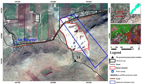
Figure 1.
Location of on-ground site 14 for analysis of the faults and fractures in the contact region between the basin and the Cause of Agourai.
2.2. Methodology
Optical images acquired in the area of study from different satellites, such as ASTER, Landsat, and Sentinel-2, were selected and downloaded from the https://earthexplorer.usgs.gov and https://scihub.copernicus.eu/dhus/#/home websites accessed on 18 May 2017. These are free satellite images with high and medium spatial resolution (10 m, 15 m, 20 m, 30 m and 60 m). In order to better analyze and identify changes in each pixel throughout the seasons, various sources of images acquired on different dates were chosen to assess these changes as karst landforms are fragile and their reflectance can change due to a climate event (Figure 2). In addition, a very high spatial resolution (0.41 m) image from Geoeye-1 acquired on 17 May 2017 was used. Geologic maps and topographic maps were used to calibrate and enhance the classification of the satellite images. Using free open-source software, such as SNAP Desktop and QGIS Sentinel-2, the images were processed, and their results were imported into ArcGIS 10.3 for layer out and data export.
We conducted fieldwork to take structural measurements on carbonate (dolomite and limestone) rocks to validate the classification and the location of different karsts extracted from the remotely sensed data. Based on the surface reflectance of the objects in different parts of the electromagnetic spectrum, we produced an overview of the land cover in the area of study using a band combination technique across the Sentinel-2 MSI imagery. The shortwave infrared band is useful for mineral mapping, which makes this band the best way to identify areas occupied by vegetation cover, carbonate rocks, basalts, and clay minerals.
A normalized difference vegetation index (NDVI) (1) was computed to provide information on areas occupied by forest, grass, cultivated, and uncultivated fields, while a normalized difference water index (NDWI) (2) provided information on the moisture variation in the area of study.
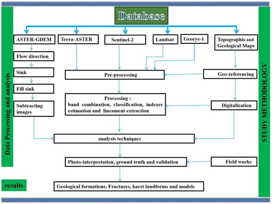
Figure 2.
Methodological workflow for data analysis, modified from Muzirafuti, 2018 [32].
The spectral signature (shown in Figure 3) extracted from the Sentinel images shows dolomite and limestone with a high reflectance in the shortwave infrared, vegetation in the near infrared, and water in blue. Based on this information, the locations of different geologic formations have been identified, with a focus on carbonate rocks likely to have developed in sinkholes. Principle component analysis was applied to maximize the information from a few bands (components), where the component with the largest amount of information was analyzed to extract lineaments related to both major faults and newly identified fractures. Two Advanced Spaceborne Thermal Emission and Reflection Radiometer Global Digital Elevation Model (ASTER-GDEM) (version 2 with 30 m of spatial resolution, acquired on 17 October 2011) maps were mosaicked and analyzed. We start by extracting the elevation, which was later compared to topographic maps, to identify depressions, cliffs, valleys, volcanoes, quarries, and slope variations. Using ArcGIS toolbox, flow direction and fill sink operations were performed on ASTER-GDEM images, and image subtraction operations were computed from processed and unprocessed images. Like other automatic operators, photo-interpretation techniques were used to identify and locate carbonate depressions.
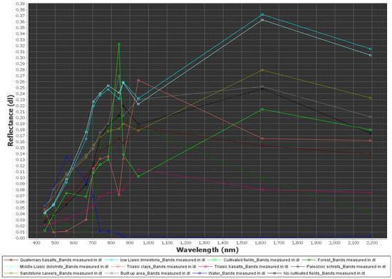
Figure 3.
Spectral signature of land cover objects based on their reflectance (dimensionless) at different electromagnetic spectrum wavelengths (nm). Extracted from Copernicus Sentinel-2 image acquired on 30 March 2017 in Tabular Middle Atlas, modified from Muzirafuti, 2018 [32].
Surface-water pathways were extracted from ASTER-GDEM, whose drainage lines direct precipitation (rainwater and melted snow) from the cause to the basin, and in some cases infiltrate into the ground through fractures. Products of anthropogenic activities, such as N and CO₂, modify the chemistry of surface water and contribute to the gradual erosion processes which in turn develop crytokarst and deepen sinkholes. These karst landforms were extracted by subtracting sink-filled and unfilled ASTER-GDEM images, which were located on both the main faults and localized fractures. Agriculture is the most dominant activity in the TMA mainly in areas occupied by Plio-quaternary geologic formations, where unfortunately, fractured carbonate rocks have developed underground cavities due to karst phenomena. Some of those cavities have created structural features, such as sinks, circular and shallow depressions, fractures, and localized vegetation observed on the surface.
The principal component analysis technique was used to maximize the information from a few bands, as every pixel of information is coded on any given number by analyzing these numbers. It is easy to identify the continuity of curvilinear or linear structures, such as faults and fractures (Figure 4). High pixel values are observed on unaltered dolomite, while low values were identified in an altered part of the carbonate rock due to the presence of gradual erosional clay (Terra-rossa).
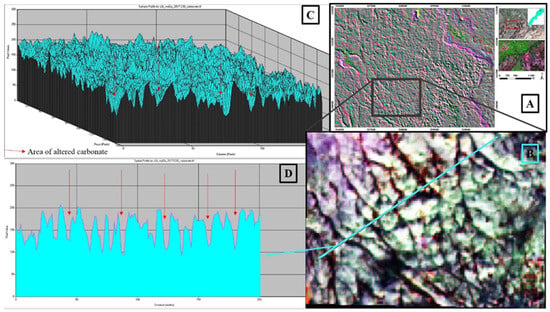
Figure 4.
Spatial (D) and surface (C) profiles extracted from a high percentage of principle component analysis results (B) in an area occupied by carbonate rocks (A). From a Copernicus Sentinel-2 image acquired on 30 March 2017 in Tabular Middle Atlas, modified from Muzirafuti, 2018 [32]. High pixel values are observed on unaltered dolomite, while low values were identified in an altered part of the carbonate rock due to the presence of gradual erosional clay (Terra-rossa) as indicated by the red arrows.
This has been enhanced by using the direction filter Sobel operator. Automatic extraction provides lineaments of different structures, such as roads, bridges, cliffs, and fields, and geological limits, fractures, faults, dykes, and veins. A manual digitization technique was used to map the various fractures of the fault systems identified in the geological formations.
3. Results
This area covers a large surface with site of biological and ecological interest in the south, the forest of Jabaa in the National Park of Ifrane, and large agricultural areas. Geologically, the area is dominated by Liassic dolomites and limestones, the quaternary basalts of El Koudiat in the south, Jbel Outgui in the northwest volcanoes, and clays and alluvial on altered carbonate rocks. The presence of these quaternary volcanoes may suggest the thickness of the lithosphere is small in this area.
The Cause of Agourai located on the western part of the fault of Adarouch, on its northern part, we identified the Ain Maarrouf water spring located in the contact between the basin and the Cause. The fault has played a big role by fracturing the rock and making it conductive enough to create the water spring complex. This complex is formed by two main springs, namely Ain Maarouf and Ain Boujaoui (Figure 5). The water from these springs is used for irrigation and everyday activities of people living in this area. On-ground measurements conducted in the sand quarry located in the contact between the Cause of Agourai and the Saiss basin revealed the role played by the fracture systems in the hydrogeological system of this area. Erosional minerals and their continuation along the NE–SW fault system testifies to their role in water infiltration to fill the water reservoirs. Analyses of the fractures observed from remotely sensed data allowed us to identify an important fracture system orientated NE–SW and E-W. Lineament mapping confirmed the presence of the two major faults systems, mainly in carbonate rocks in the NE–SW and E–W (Figure 5). The area of study is also affected by the NW–SE fractures, which have played a role in the development of the water spring complex of Ain Maarrouf and Ain Boujaoui, located in the contact region of the Saiss basin with the Cause of Agourai.
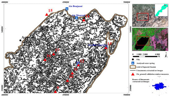
Figure 5.
Lineaments extracted from a Copernicus Sentinel-2 image acquired in the Cause of Agourai. With numbers indicating the position of the on-ground sites of the measurements of the fractures.
The Ain Maarouf and Ain Boujaoui water springs and other water outpourings observed at the contact between the basin and the cause along the NE–SW fault systems demonstrate their drainage role from the Cause of Agourai to the basin of Saiss. This system is different from the one which is involved in the drainage from the main TMA to the basin of Saiss and the drainage pathway of the water for the spring located in the region.
The results obtained from on-ground measurements (Figure 6) confirmed the presence of the large fracture system, mainly in the NE–SW (Figure 7). We also identified syn-sedimentary fractures resulting from the reactivation of these two fractures systems. Ground measurements in the sandy quarry revealed how this fault played a role in the formation of this spring. This normal fault has created a graben allowing the water reservoir to find a way out through its fault scarp.
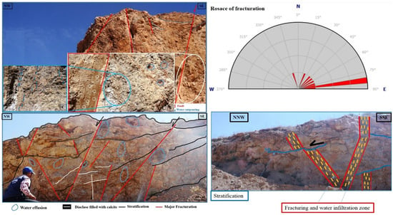
Figure 6.
On-ground measurements at the contact between the Cause of Agourai and the Saiss basin. Analyses were conducted on site 14 as shown in Figure 5, modified from Muzirafuti, 2018 [32].
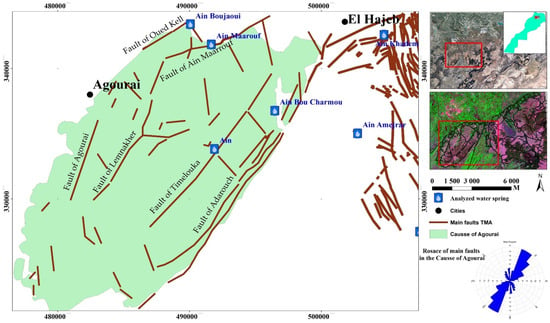
Figure 7.
New and existing main faults extracted from satellite images in the Cause of Agourai.
4. Discussion
We compared the results obtained from the data acquired around Ain Maarouf and the results obtained from the data acquired around other springs located at the contact between the main TMA and the basin of Saiss. On the eastward side of the Cause of Agourai, we identified the Ain Amejrar water spring (Figure 8), and structural measurements taken on carbonate rocks revealed the area of water infiltration through permeable zones (Figure 8). This area holds a water spring complex located at the contact between the Cause of El Hajeb and the Central Massif. The spring complex is characterized by low outpouring and has developed from slightly folded Liassic carbonate rocks with fractures oriented in the NW–SE direction.
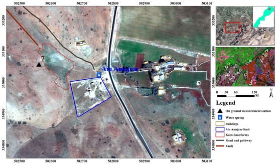
Figure 8.
Location of the Ain Amejrar water spring located in the contact region between the TMA and the Central Massif of Morocco.
Locally, the limestones also present a brecciated appearance. Around the source, we observed tabular or sub-tabular formations with little or no deformation. These are Liasic deposits constituting the main cover of the Middle Atlas Cause and are mainly formed by dolomitic limestone that is whitish to yellowish in colour. On-ground fracture measurements conducted around the water spring of Ain Amejrar consisted of the collection of measurements on the fractures from a quantitative and qualitative point of view.
The analysis of the direction and the dip shows that the fracture system family in the NE–SW direction intersects the one in the NW–SE direction which would therefore have formed later. In this area, a description of the fracturing that we observed at the different sites around the Amjerar spring was carried out (Figure 9). The directional roses have been developed with 10th grade classes. The directional analysis of all the fractures noted in the four sites of the Ain Amejrar divining complex shows that there are four main fracture system families of privileged directions. According to the direction of flow noted on the piezometric map, it is very probable that the NW–SE-oriented fractures drain the most groundwater from the cause around the Cause.
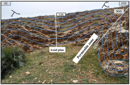
Figure 9.
Flexural-slip Anticline-fault on-ground measurement around the Ain Amejrar water spring located in the contact region between the TMA and the Central Massif of Morocco, as shown from the site 7 in Figure 8, modified from Muzirafuti, 2019 [33].
In addition, we analyzed the data acquired in the northeastern limit of the TMA and the basin of Saiss. The data were acquired around three water springs, namely Ain Bittit, Ain Ribaa, and Ain Aguemguem, located in the contact region between the Cause of El Hajeb and the basin of Saiss (Figure 10). This water spring complex constitutes the main source of fresh water used by the populations living in the cities of Fez and Meknes. Two main faults systems, NE–SW and NW–SE, were identified (Figure 11, Figure 12, Figure 13 and Figure 14). This has been confirmed by a geophysical survey conducted in this region [8], which revealed the continuity of these faults until the water spring and the location of karst depressions extracted from satellite images. The NW–SE fault system has been identified as one which drains water from the TMA to the basin, where the large number of fractures developed in the carbonate rocks played an important role in the high water flow from this spring, while the NE–SW system was interpreted as infiltration pathways, hence the distribution of karst depressions in the NE–SW direction.
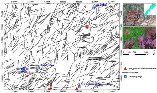
Figure 10.
Lineament extracted from a Copernicus Sentinel-2 image acquired in the Tabular Middle Atlas with number indicating the positions of the on-ground fracture measurements around the water springs of Ain Bittit, Ain Ribaa, Ain Atrous and Ain Aguemguem.
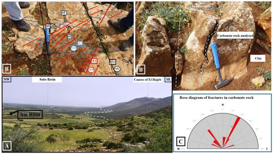
Figure 11.
The direction of fractures (C) extracted from carbonate rocks (B) around the water spring of Ain Bittit (A). Measurements were conducted at the site 1 as shown in Figure 10, modified from Muzirafuti, 2018 [32].
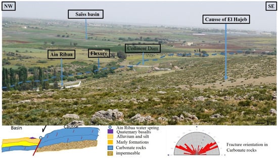
Figure 12.
Direction of fractures extracted from carbonated rocks around Ain Ribaa. Measurements were conducted on site 2 as shown in Figure 10, modified from Muzirafuti, 2018 [32].
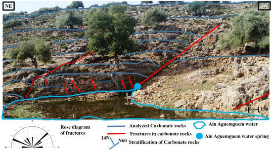
Figure 13.
The direction of fractures extracted from carbonated rocks around Ain Agueguem. Measurements were conducted on site 3 as shown in Figure 10.
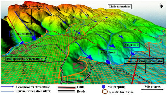
Figure 14.
Hydrogeological conceptual model of the water springs located in the contact region between the Tabular Middle Atlas and the Saiss basin.
On-ground measurements conducted along the flexure on the Ain Ribaa water spring located in the contact region of the TMA and the Saiss basin, in conjunction with very high-resolution satellite images, revealed many depressions along the NE–SW axis, which indicates their development is associated with this geological structure. Fracture analysis shows their orientation in three directions, where the NE–SW fault represents 37%, the sub-meridian fault represents 22%, and the NW–SE fault represents 30%. Quaternary volcanism-deposited basalts in these faults and in numerous karst depressions were also observed.
Another water spring located in the TMA and the basin, but not associated with this flexure, is Ain Aguemguem. In this region, many karst depressions filled with basalt have been identified and the analysis of carbonate fractures shows that they are associated with the NE–SW fault system, while the NW–SE system drains the water reservoir to the spring. During the season of high precipitation, we observe a high-water level in Lake Aguemguem (Figure 13). This ecological site holds different animal species, such as turtles, fish, and the cattle of people living nearby. This water is also used for agricultural irrigation in the fields located in this region.
Apart from the analyses conducted from the data acquired from the sites located in the contact region of the TMA and the basin of Saiss, we analyzed the fractures and inventoried the water springs in the whole TMA (Figure 15 and Figure 16). The information on carbonate depression, geology, land cover, fault systems, and elevation were used to develop a model of the karst landforms’ susceptibility (Figure 16). Previous studies suggested that the chemistry of this water is altered by anthropogenic activities and, consequently, enhances the dissolution of carbonated rock which reaches Ain Ribaa through the NW–SE fault system. This enhanced gradual erosion of carbonate rock has also been demonstrated at the surface where collapsing sinkholes are developing. However, people living in this area may not be aware of the connection between these sinkholes and the deep hydrogeological system. In addition, the junction of the ENE–WSW and NNE–SSW fault systems in carbonate rocks make this area ideal for karst development. A closer look model helps to identify local karst landforms, such as important water springs, and understand the hydrogeological system. Turbidity phenomena, observed at the Ain Ribaa water spring in previous studies [9,10], may be intensified by geogenic pollution and anthropogenic activities carried out in the karst depression located in its southeast.
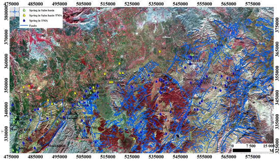
Figure 15.
Water springs and lineaments extracted from the Copernicus Sentinel-2 image acquired in the Tabular Middle Atlas.
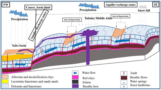
Figure 16.
Karst landforms susceptibility model of the Tabular Middle Atlas. Modified from Muzirafuti, 2018 [32].
5. Conclusions
This study shows the importance of remote sensing techniques and GIS tools in conducting geomorphological studies. The combination of satellite images and ground measurements provides a robust tool for studies conducted in large and hard-to-reach areas. We analyzed changes in vegetation using NDVI, changes on surface water, soil minerals, and built-up areas using band combinations. Lineament fractures were extracted based on the reflectance variation on pixels using principal component analysis results, while the karst depressions were extracted, automatically and manually digitized, and filtered on GDEM. The combination of information on elevation, geology, land cover, and fault systems led to the establishment of a conceptual model of the TMA. Their comparison with multi-temporal satellite images helped identify potential karst. GPS, field data, and very-high resolution satellite images were used to calibrate and validate potential maps and provide regional high precision maps. By applying the principle of cross-cutting relationships on fractures during field work, we noticed that they are not formed at the same time: the NE–SW fault system was interpreted as the first to have affected carbonate rocks; while faults, fissures, and cracks orientated in NW–SE direction were formed later. The karst identified in these agricultural areas needs to be protected from the human impact on its quality, while at the same taking advantage of economic activities conducted in this area. Ain Maarrouf water spring, located in the contact region of the Cause of Agourai and the Saiss basin, is the result of water discharge from the water reservoir located in the TMA. Human activities may be having an impact on the structure of this karst environment. Their impact is observed on the quantity of groundwater extracted for irrigation, and also on the water solutes which alter the chemistry of infiltrated surface water. On the other hand, ongoing climate change has an impact on the aquifer recharge zones through the reduction of precipitation needed for infiltration.
Funding
This research received no external funding.
Data Availability Statement
The data presented in this study are available on request from the author.
Conflicts of Interest
The author declares no conflict of interest.
References
- Sarker, S.K.; Zhu, J.; Fryar, A.E.; Jeelani, G. Hydrological Functioning and Water Availability in a Himalayan Karst Basin under Climate Change. Sustainability 2023, 15, 8666. [Google Scholar] [CrossRef]
- Olarinoye, T.; Gleeson, T.; Marx, V.; Seeger, S.; Adinehvand, R.; Allocca, V.; Andreo, B.; Apaéstegui, J.; Apolit, C.; Arfib, B.; et al. Global karst springs hydrograph dataset for research and management of the world’s fastest-flowing groundwater. Sci. Data 2020, 7, 254. [Google Scholar] [CrossRef] [PubMed]
- Howell, B.; Fryar, A.; Benaabidate, A.E.; Bouchaou, L.; Farhaoui, M. Variable responses of karst springs to recharge in the Middle Atlas region of Morocco. Hydrogeol. J. 2019, 27, 1693–1710. [Google Scholar] [CrossRef]
- Muzirafuti, A.; Boualoul, M.; Randazzo, G.; Lanza, S.; Allaoui, A.; El Ouardi, H.; Habibi, M.; Ouhaddach, H. The use of remote sensing for water protection in the karst environment of the Tabular Middle Atlas/the causse of El Hajeb/Morocco. In Earth Observation Advancements in a Changing World; Chirici, G., Gianinetto, M., Eds.; AIT Series, Trends in Earth Observation; Italian Society of Remote Sensing: Firenze, Italy, 2019. [Google Scholar]
- Muzirafuti, A.; Boualoul, M.; Barreca, G.; Allaoui, A.; Bouikbane, H.; Lanza, S.; Crupi, A.; Randazzo, G. Fusion of Remote Sensing and Applied Geophysics for Sinkholes Identification in Tabular Middle Atlas of Morocco (the Causse of El Hajeb): Impact on the Protection of Water Resource. Resources 2020, 9, 51. [Google Scholar] [CrossRef]
- Amraoui, F. Contribution à la Connaissance des Aquifères Karstiques: Cas du Lias de la Plaine du Saïs et du Causse Moyen Atlasique Tabulaire (Maroc). Ph.D. Thesis, Université Hassan II, Casablanca, Morocco, 2005. [Google Scholar]
- Qadem, A. Quantification, Modelisation et Gestion de la Ressource en Eau Dans le Bassin Versant du Haut Sebau (Maroc). Ph.D. Thesis, Université Sidi Mohamed Ben Abdelah de Fès, Fes, Morocco, Université de Lorraine, Lorraine, France, 2015; p. 37. [Google Scholar]
- Qarqori, K. Contribution à l’étude du Réservoir Discontinu et Karstique des Causses Moyen-Atlasiques et de sa Jonction Avec le Bassin de Saïs par Télédétection Spatiale et Imagerie Géophysique [Contribution to the Study of the Discontinuous and Karstic Reservoir of the Middle Atlasic Causses and Its Junction with the Saïs Basin by Remote Sensing and Geophysical Imagery]. Ph.D. Thesis, Moulay Ismail University, Meknes, Morocco, 2015. [Google Scholar]
- Miche, H.; Saracco, G.; Mayer, A.; Qarqori, K.; Rouai, M.; Dekayir, A.; Chalikakis, K.; Emblanch, C. Hydrochemical constraints between the karst tabular Middle Atlas Causses and the Saïs basin (Morocco): Implications of groundwater circulation. J. Hydrogeol. 2018, 26, 71–87. [Google Scholar] [CrossRef]
- Howell, B.A. Spring Responses to Stroms and Seasonal Variations in Recharge in the Middle Atlas Region of Morocco. Theses and Dissertations—Earth and Environmental Sciences. P41. 2016. Available online: https://Uknowledge.uky.edu/ees_etds/41 (accessed on 1 February 2024).
- El-Ouardi, H.; Boualoul, M.; Ouhaddach, H.; Habib, M.; Muzarafuti, A.; Allaoui, A.; Amine, A. Fault analysis and its relationship with karst structures affecting lower Jurassic limestone in the Agourai plateau (Middle Atlas, Morocco). Geogaceta 2018, 63, 119–122. [Google Scholar]
- El Makrini, S.; Boualoul, M.; Mamouch, Y.; El Makrini, H.; Allaoui, A.; Randazzo, G.; Roubil, A.; El Hafyani, M.; Lanza, S.; Muzirafuti, A. Vertical Electrical Sounding (VES) Technique to Map Potential Aquifers of the Guigou Plain (Middle Atlas, Morocco): Hydrogeological Implications. Appl. Sci. 2022, 12, 12829. [Google Scholar] [CrossRef]
- Bouya, N.; El Ouardi, H.; Habibou, E.H.; Mercier, E.; Ansan, V. Interprétation géologique des données aéromagnétiques et leur utilisation pour la cartographie des structures du plateau d’Agourai (Moyen Atlas tabulaire, Maroc). Afr. Geosci. Rev. 2013, 20, 13–20. [Google Scholar]
- The Ministries of Mines, Energy, Water and Environment (Morocco). Saïss Water Conservation Project—Environmental and Social Appraisal and Action Plan; The Ministries of Mines, Energy, Water and Environment: Rabat, Morocco, 2017; p. 34. [Google Scholar]
- El Ouali, A.; El Hafyani, M.; Roubil, A.; Lahrach, A.; Essahlaoui, A.; Hamid, F.E.; Muzirafuti, A.; Paraforos, D.S.; Lanza, S.; Randazzo, G. Modeling and Spatiotemporal Mapping of Water Quality through Remote Sensing Techniques: A Case Study of the Hassan Addakhil Dam. Appl. Sci. 2021, 11, 9297. [Google Scholar] [CrossRef]
- Muzirafuti, A.; Lanza, S.; Paltrinieri, D.; Faina, G.; El Hafyani, M.; Randazzo, G. Geomorphology in the Digital Age: A Case Study Project of Quantitative Geomorphology from Images. In Proceedings of the 2023 International Workshop on Metrology for the Sea; Learning to Measure Sea Health Parameters (MetroSea), La Valletta, Malta, 4–6 October 2023; pp. 513–518. [Google Scholar]
- Theilen-Willige, B.; Malek, H.A.; Charif, A.; El Bchari, F.; Chaïbi, M. Remote Sensing and GIS Contribution to the Investigation of Karst Landscapes in NW-Morocco. Geosciences 2014, 4, 50–72. [Google Scholar] [CrossRef]
- Harishidayat, D.; Al-Shuhail, A.; Randazzo, G.; Lanza, S.; Muzirafuti, A. Reconstruction of Land and Marine Features by Seismic and Surface Geomorphology Techniques. Appl. Sci. 2022, 12, 9611. [Google Scholar] [CrossRef]
- Siart, C.; Bubenzer, O.; Eitel, B. Combining digital elevation data (SRTM/ASTER), high resolution satellite imagery (Quickbird) and GIS for geomorphological mapping: A multi-component case study on Mediterranean karst in Central Crete. Geomorphology 2009, 112, 106–121. [Google Scholar] [CrossRef]
- Deslandes, S.; Gwyn, Q.H.J. Evaluation de spot et SEASAT pour la cartographie des linéaments: Comparaison basée sur l’analyse de spectre de Fourrier (spot and SEASAT evaluation for mapping lineaments: Comparison based on Fourier spectrum analysis). Can. J. Remote Sens. 1991, 17, 98–110. [Google Scholar] [CrossRef]
- Stumpf, A.; Malet, J.P.; Kerle, N.; Niethammer, U.; Rothmund, S. Image-based mapping of surface fissures for the investigation of landslide dynamics. Geomorphology 2013, 186, 12–27. [Google Scholar] [CrossRef]
- Bemis, S.P.; Micklethwaite, S.; Turner, D.; James, M.R.; Akciz, S.; Thiele, S.T.; Bangash, H.A. Ground-based and UAV-Based photogrammetry: A multi-scale, high-resolution mapping tool for structural geology and paleoseismology. J. Struct. Geol. 2014, 69, 163–178. [Google Scholar] [CrossRef]
- de Carvalho Júnior, O.A.; Guimarães, R.F.; Montgomery, D.R.; Gillespie, A.R.; Gomes, R.A.T.; de Souza Martins, É.; Silva, N.C. Karst Depression Detection Using ASTER, ALOS/PRISM and SRTM-Derived Digital Elevation Models in the Bambuí Group, Brazil. Remote Sens. 2014, 6, 330–351. [Google Scholar] [CrossRef]
- Adewumi, J.R.; Akomolafe, J.K.; Ajibade, F.O.; Fabeku, B.B. Application of GIS and Remote Sensing Technique to Change Detection in Land Use/Land Cover Mapping of Igbokoda, Ondo State, Nigeria. J. Appl. Sci. Process Eng. 2016, 3, 34–54. [Google Scholar] [CrossRef]
- Adewumia, J.R.; Akomolafe, J.K.; Ajibade, F.O. Development of Flood Prone Area Map for Igbokoda Township using Geospatial Technique. J. Appl. Sci. Process Eng. 2017, 4, 158–178. [Google Scholar] [CrossRef][Green Version]
- Kim, J.W.; Lu, Z. Association between localized geohazards in West Texas and human activities, recognized by Sentinel-1A/B satellite radar imagery. Sci. Rep. 2018, 8, 4727. [Google Scholar] [CrossRef]
- De Waele, J.; Gutierrez, F. Karst Hydrologeology, Geomorphology and Caves; Wiley: Hoboken, NJ, USA, 2022; ISBN 9781119605348. [Google Scholar]
- Aouragh, M.H. Cartographie et Identification par Télédétection et Analyse Multicritère Sous SIG des Zones Potentielles des Aquifères au Niveau du Causse Moyen Atlasique (Maroc). Ph.D. Thesis, Université Moulay Ismail/Faculté des Sciences Meknès, Meknes, Morocco, 2015. [Google Scholar]
- Bouikbane, H. Apport d’un Couplage Géophysique et Hydrogéochimique à L’étude du Transfert Naturel des Ecoulements Souterrains Entre le Causse Calcaire d’el Hajeb-Ifrane et la Plaine de Saïss (Maroc). Ph.D. Thesis, Université Moulay Ismail/Faculté des Sciences Meknès, Meknes, Morocco, 2015. [Google Scholar]
- Akdim, B.; Amyay, M. Environmental vulnerability and agriculture in the karstic domain: Landscape indicators and cases in the Atlas Highlands, Morocco. Int. J. Speleol. 1999, 28B, 119–138. [Google Scholar] [CrossRef]
- Hassan, M.; Ahmed, M.; Toufik, R.; Mustapha, B.; Fouad, E.K.; Mounir, A.; Mehdi, M.; Iz-Eddine, E.A. Deep quaternary volcanic structures in the central Middle Atlas (Morocco): Contributions of aeromagnetic mapping (structures profondes du volcanisme quaternaire du Moyen Atlas central (Maroc): Apports de la cartographie aéromagnétique. Bull. L’institut Sci. Rabat 2016, 38, 111–125. [Google Scholar]
- Muzirafuti, A. Applied Geophysics and Remote Sensing for Water Protection in Karst Environment, El Hajeb Causse/Morocco. Zenodo. Available online: https://explore.openaire.eu/search/publication?pid=10.5281%2Fzenodo.3552337 (accessed on 18 July 2018).
- Muzirafuti, A. Geological Mapping and Soil Characterization in Identifying Agricultural Related Hazards Using Freely-Available Copernicus-Sentinel Data, Leading to Best-Practices for Sustainable Agriculture in Tabular Middle Atlas/Morocco. Zenodo. Available online: https://zenodo.org/records/3552793 (accessed on 25 November 2019).
Disclaimer/Publisher’s Note: The statements, opinions and data contained in all publications are solely those of the individual author(s) and contributor(s) and not of MDPI and/or the editor(s). MDPI and/or the editor(s) disclaim responsibility for any injury to people or property resulting from any ideas, methods, instructions or products referred to in the content. |
© 2024 by the author. Licensee MDPI, Basel, Switzerland. This article is an open access article distributed under the terms and conditions of the Creative Commons Attribution (CC BY) license (https://creativecommons.org/licenses/by/4.0/).