

Columbia River Rhyolites: Age-Distribution Patterns and Their Implications for Arrival, Location, and Dispersion of Continental Flood Basalt Magmas in the Crust

 ,
,
Abstract
1. Introduction
Historical Perspective on Rhyolites of the Columbia River Province
2. Methods
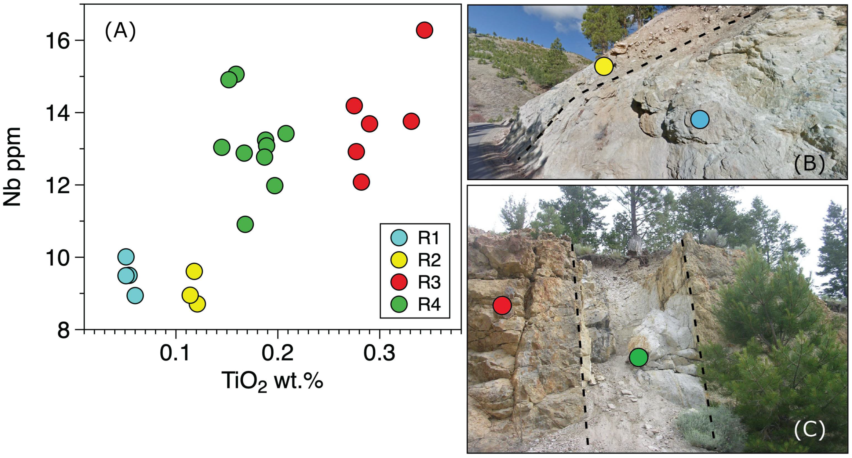
3. Results
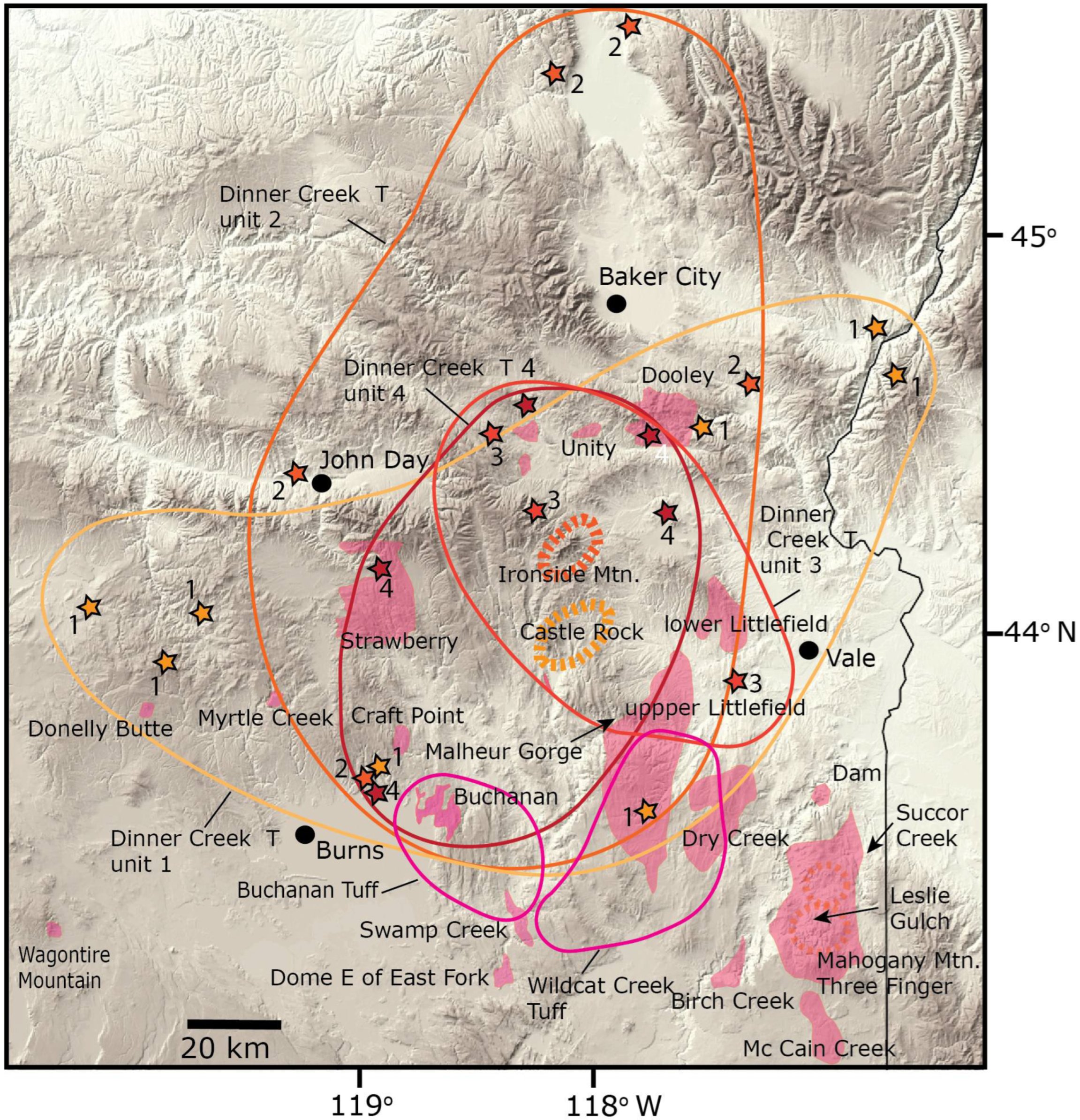
3.1. Mid Miocene Rhyolite Centers in Eastern Oregon
3.1.1. Dooley Mountain Rhyolite Field
3.1.2. Strawberry Rhyolite Field (2 in Figure 4)
3.1.3. Unity Area Rhyolites (3 in Figure 4)
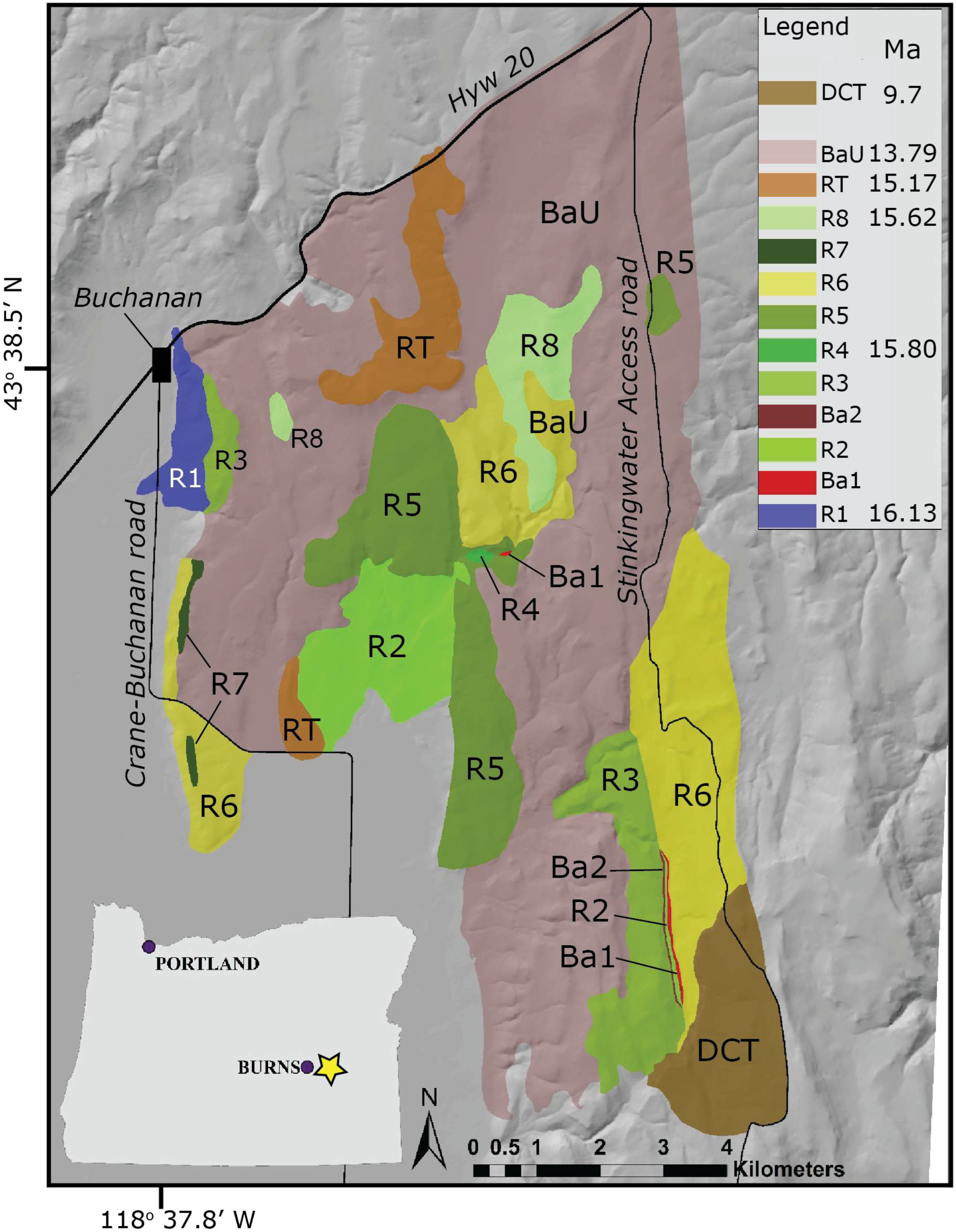
3.1.4. Buchanan Rhyolite Complex (10 in Figure 4) and Nearby Centers to the South (16 in Figure 4)

| Dooley Mountain | Sample # | Location/Unit | Material | Age [FCT 28.2] | 2 Sigma | Method | K/Ca | 2 Sigma | N | Lab/Year | Reported by | |
|---|---|---|---|---|---|---|---|---|---|---|---|---|
| Dooley | EJ-12-23A | R2 unit | Sanidine | 15.59 | 0.04 | weighted plateau | 41.7 | OSU | [69] | |||
| Dooley | DM 240 | R3 unit | Plagioclase | 15.539 | 0.047 | single crystal | 0.11 | 0.02 | 49 | NMT | this study | |
| Dooley | DM 265A | R4 unit | Plagioclase | 15.44 | 0.10 | single crystal | 0.13 | 0.01 | 26 | NMT | this study | |
| Dooley | MS-11-22 | R4 unit (tuff dike) | Plagioclase | 15.491 | 0.031 | single crystal | 0.13 | 0.02 | 36 | NMT | this study | |
| Dooley | MS-17-14 | R4 unit, north patch | Plagioclase | 15.587 | 0.059 | single crystal | 0.12 | 0.02 | 28 | NMT | this study | |
| Unity | Sample # | Location/unit | Material | Age [FCT 28.2] | 2 sigma | Method | K/Ca | 2 sigma | N | Lab | Reported by | |
| Unity | CR-U4b | below DIT2 tuff | Plagioclase | 16.53 | 0.14 | weighted plateau | 0.15 | OSU | [69] | |||
| Unity | CR-U3B | Sanidine | 16.695 | 0.010 | single crystal | 47 | 51 | 5 | NMT | this study | ||
| Unity | MS-12-14UR | Plagioclase | 17.02 | 0.14 | single crystal | 0.08 | 0.05 | 12 | NMT | this study | ||
| Strawberry | Sample # | Location/unit | Material | Age [FCT 28.2] | 2 sigma | Method | K/Ca | 2 sigma | N | Lab | Reported by | |
| Strawberry | AS-SV-144 | Plagioclase | 15.34 | 0.52 | weighted plateau | 0.039 | OSU | [70] | ||||
| Strawberry | AS-SV-151 | Groundmass | 16.16 | 0.17 | weighted plateau | OSU | [70] | |||||
| Strawberry | AS-SV-151 | Plagioclase | 16.12 | 0.7 | weighted plateau | 0.04 | OSU | [70] | ||||
| Strawberry | AS-SV-173 | Biotite | 14.70 | 0.13 | weighted plateau | OSU | [70] | |||||
| Strawberry | AS-SV-179 | Groundmass | 15.30 | 0.1 | weighted plateau | OSU | [70] | |||||
| Strawberry | AS-SV-190 | Groundmass | 14.79 | 0.12 | weighted plateau | OSU | [70] | |||||
| Strawberry | MS-14-23 | Obsidian | 14.81 | 0.04 | weighted plateau | 8 | NMT | [70] | ||||
| Strawberry | JJ-17-8 | Plagioclase | 14.463 | 0.037 | single crystal | 0.05 | 0.04 | 17 | NMT | this study | ||
| Strawberry | MS-17-05 | Plagioclase | 15.112 | 0.030 | single crystal | 0.11 | 0.05 | 25 | NMT | this study | ||
| Upper/Lower Littlefield Rhyolite | Sample # | Location/unit | Material | Age [FCT 28.2] | 2 sigma | Method | K/Ca | N | Lab | Reported by | ||
| upper Littlefield Rhyolite | multiple samples | 16.05 | [71] | |||||||||
| lower Littlefield Rhyolite | multiple samples | 16.15 | [71] | |||||||||
| Buchanan | Sample # | Location/unit | Material | Age [FCT 28.2] | 2 sigma | Method | K/Ca | N | Lab | Reported by | ||
| Buchanan | EJ-12-03 | R1 unit | Sanidine | 16.13 | 0.11 | weighted plateau | 41.7 | OSU | [69] | |||
| Buchanan | B156 | R4 unit | Sanidine | 15.803 | 0.014 | single crystal | 20.6 | 2.2 | 25 | NMT | this study | |
| Buchanan | B109 | R8 unit | Plagioclase | 15.62 | 0.31 | single crystal | 0.09 | 0.05 | 15 | NMT | this study | |
| tuff of Buchanan | MS-13-07 | tops lava flow complex | Anorthoclase | 15.171 | 0.013 | single crystal | 3.9 | 1.5 | 25 | NMT | this study | |
| Mahogany-Three Fingers Succor Creek area | Sample # | Location/unit | Material | Age [FCT 28.2] | 2 sigma | Method | K/Ca | N | Lab | Reported by | ||
| Mahogany-Three Fingers | EJ-12-12 | Devils Gate | Anorthoclase | 15.94 | 0.16 | weighted plateau | 6.6 | OSU | [69] | |||
| Mahogany-Three Fingers | TF88A | Three Fingers (TF) | Sanidine | 15.74 | 0.08 | weighted plateau | 41.2 | OSU | [72] | |||
| Mahogany-Three Fingers | EJ-12-14 | McIntyre Ridge | Sanidine | 15.78 | 0.03 | single crystal | 20 | 12.9 | 11 | NMT | this study | |
| Mahogany-Three Fingers | MS-11-15SCT | Succor Creek Tuff | Anorthoclase | 15.74 | 0.09 | weighted plateau | 6.2 | OSU | [72] | |||
| Mahogany-Three Fingers | CB-18-02 | base of LGT at Succor Creek | feldspar | 15.98 | 0.05 | single crystal | OSU | [73] | ||||
| Mahogany-Three Fingers | CB-19-65 | Devils Gate | feldspar | 16.02 | 0.02 | single crystal | OSU | [73] | ||||
| Mahogany-Three Fingers | CB-19-44 | feldspar | 15.95 | 0.03 | single crystal | OSU | [73] | |||||
| Mahogany-Three Fingers | MS-10-06 | “outflow” LTG | Sanidine | 15.87 | 0.03 | single crystal | 7.3 | 2.5 | 10 | NMT | this study | |
| Leslie Gulch area and nearby | Sample # | Location/unit | Material | Age [FCT 28.2] | 2 sigma | Method | K/Ca | N | Lab | Reported by | ||
| Mahogany-Three Fingers | RJ-18-03 | Mahogany Mountain | feldspar | 15.71 | 0.05 | single crystal | OSU | [74] | ||||
| Mahogany-Three Fingers | RJ-18-05 | Mahogany Mountain | feldspar | 15.83 | 0.04 | single crystal | OSU | [74] | ||||
| Mahogany-Three Fingers | RJ-18-11 | Mahogany Mountain | feldspar | 15.81 | 0.06 | single crystal | OSU | [74] | ||||
| Mahogany-Three Fingers | RJ-18-50 | Mahogany Mountain | feldspar | 15.82 | 0.05 | single crystal | OSU | [74] | ||||
| Mahogany-Three Fingers | MS-12-39b | Tuff of Leslie Gulch | Sanidine | 15.948 | 0.037 | single crystal | 9.5 | 3 | 6 | NMT | this study | |
| Mahogany-Three Fingers | MS-13-27 | tuff below TF | Sanidine | 15.928 | 0.007 | single crystal | 228 | 148 | 14 | NMT | this study | |
| Mahogany-Three Fingers | MS-17-15 | Pre-LTG lava | Sanidine | 16.042 | 0.016 | single crystal | 9.50 | 2.00 | 29 | NMT | this study | |
| Dinner Creek Tuff (DIT) | Sample # | Location/unit | Material | Age [FCT 28.2] | 2 sigma | Method | K/Ca | N | Lab | Reported by | ||
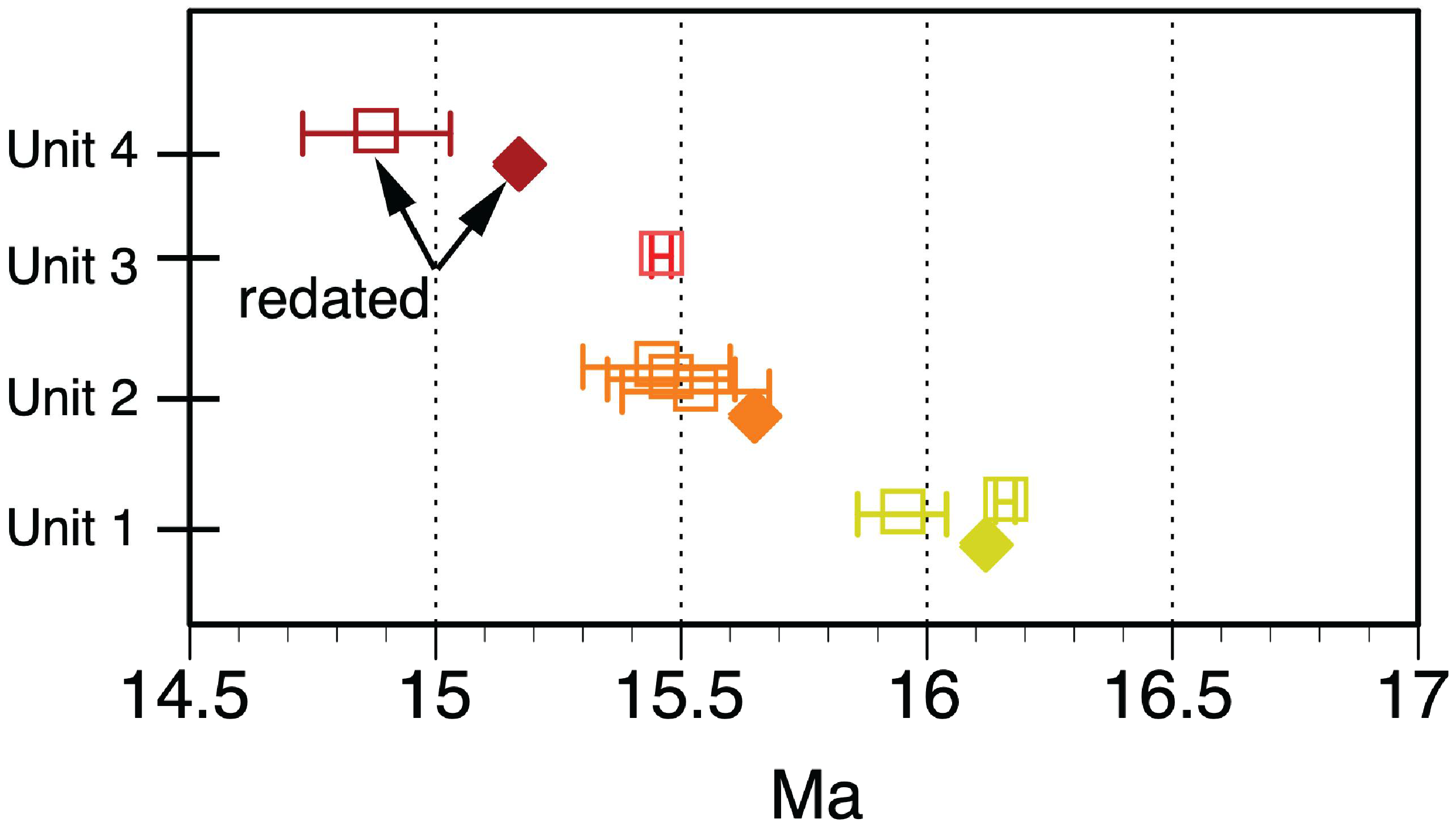
| Unit 1 | MS-12-29.1 | at Brogan | An10 plag | 16.16 | 0.02 | single crystal | 0.73 | 9 | NMT | [19] | ||
| Unit 1 | MS-DIT1 | type locality | An10 plag | 16.120 | 0.026 | single crystal | 0.74 | 0.09 | 36 | NMT | this study | |
| Unit 2 | MS-15-12.3 | capping Spying Glass CRBG flow | An20 plag | 15.653 | 0.038 | single crystal | 0.2 | 0.1 | 35 | NMT | this study | |
| Unit 3 | MS-12-38 | at Bully Creek | Anorthoclase | 15.458 | 0.021 | single crystal | 2.65 | NMT | [19] | |||
| Unit 4 | MS-11-20 | Anorthoclase | 15.173 | 0.010 | single crystal | 14.7 | 74.2 | 11 | NMT | this study | ||
| Other ages with lower precision are found in [19], but all are displayed in Figure 8. | ||||||||||||
| Various units | Sample # | Location/unit | Material | Age [FCT 28.2] | 2 sigma | Method | K/Ca | N | Lab | Reported by | ||
| Birch Creek | V19-068 | Plagioclase | 15.52 | 0.05 | single crystal | 29/30 | OSU | [34] | ||||
| Birch Creek | V19-079 | Plagioclase | 14.94 | 0.2 | single crystal | 29/30 | OSU | [34] | ||||
| McCain Creek | RJ-18-57 | feldspar | 14.41 | 0.04 | single crystal | OSU | [74] | |||||
| Lake Owyhee Dam | MS-17-DAM | Plagioclase | 14.74 | 0.02 | single crystal | 30/30 | OSU | [34] | ||||
| Dry Creek | VS19-116 | Plagioclase | 14.78 | 0.03 | single crystal | 24/30 | OSU | [34] | ||||
| Beulah Reservoir | EJ-12-07 | pre-DIT caldera rhyolite | Groundmass | 16.29 | 0.21 | weighted plateau | OSU | [69] | ||||
| Swamp Creek | EJ-12-06A | Obsidian | 16.14 | 0.12 | weighted plateau/total fusion | OSU | [69] | |||||
| Dome E of South Fork | VS19-080 | Groundmass | 16.81 | 0.05 | weighted plateau | - | OSU | [34] | ||||
| Wildcat Creek Tuff | MS-14-05 | Anorthoclase | 15.489 | 0.022 | single crystal | 2.3 | 0.8 | 13 | NMT | this study | ||
| Donnelly Butte | EJ-12-02 | Groundmass | 15.59 | 0.06 | weighted plateau | NMT | [34] | |||||
| Wagontire Mountain | VS20-125A | Plagioclase | 14.79 | 0.05 | single crystal | 25/30 | OSU | [34] | ||||
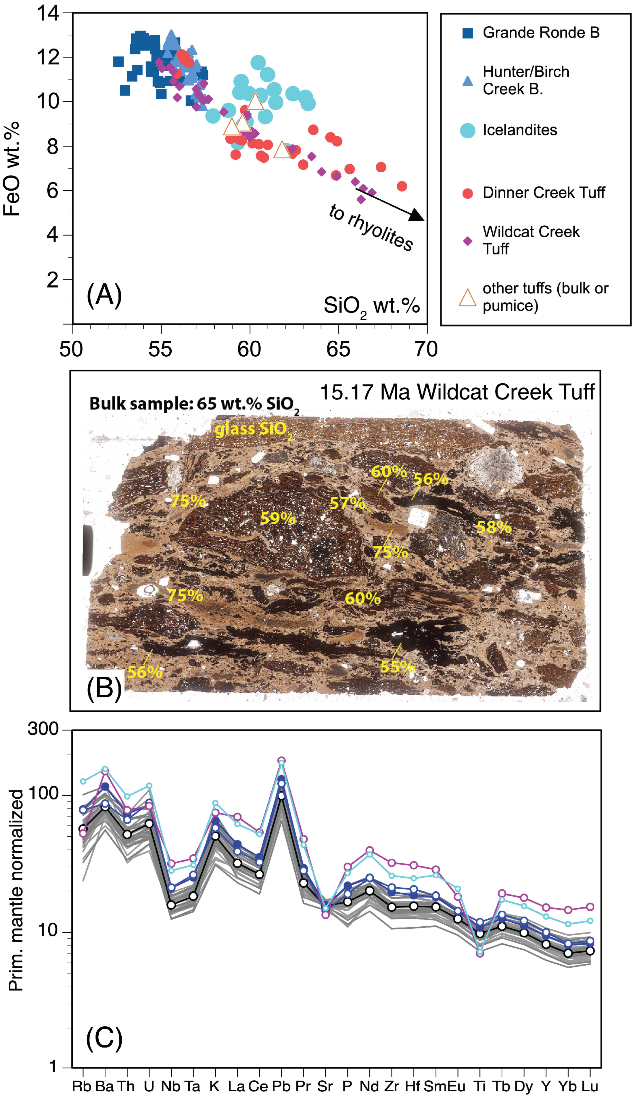
3.1.5. Dinner Creek Tuff (4, 5, 6 in Figure 4)
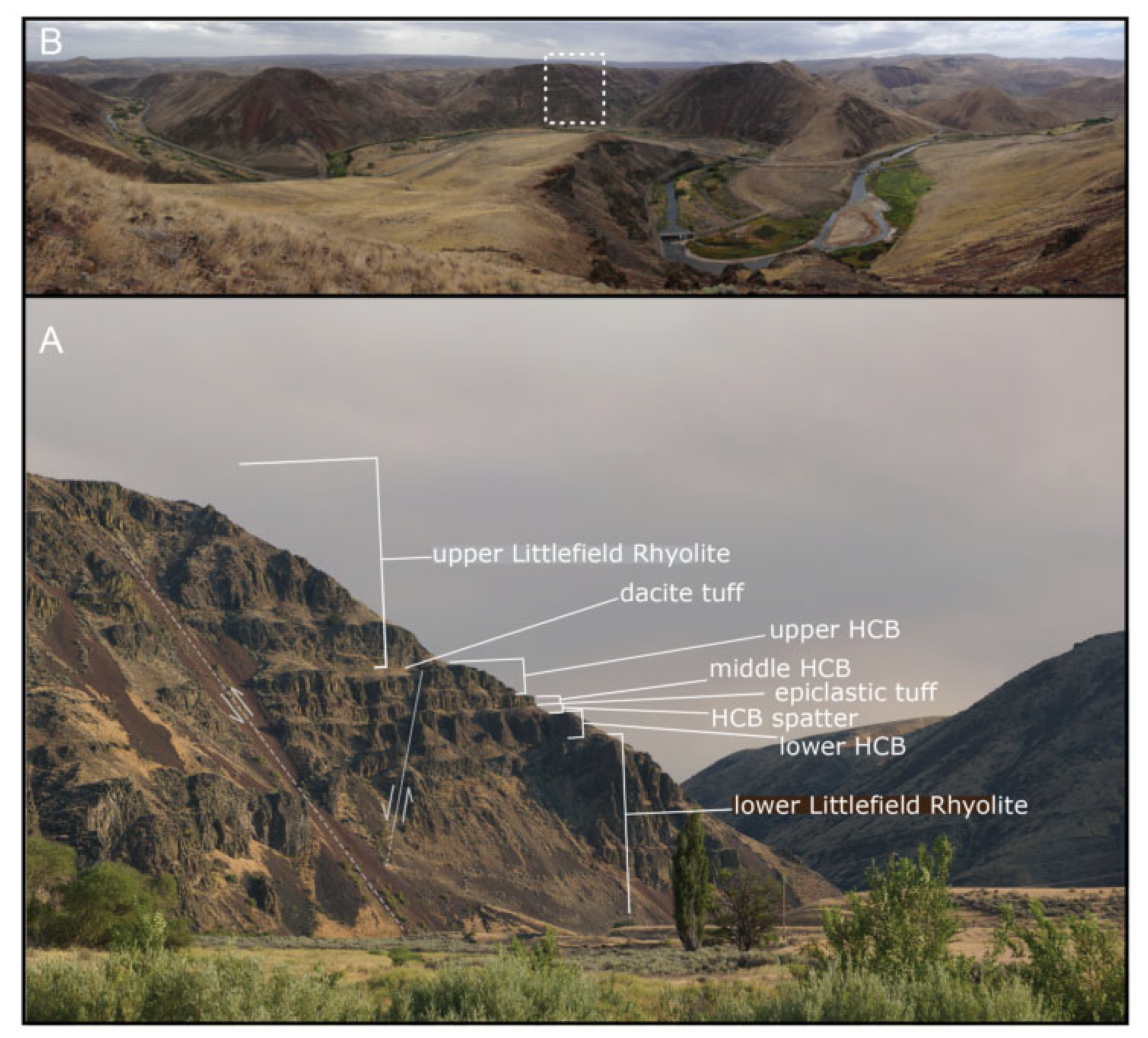
3.1.6. Littlefield Rhyolite (7 and 8 in Figure 4) and Wildcat Creek Tuff (11 in Figure 4)
3.1.7. Mahogany Mountain—Three Fingers (12 in Figure 4) and Nearby Rhyolite Fields (9, 13, 14, 15 in Figure 4)
3.1.8. Rhyolites along the Western Margin (17, 18, 19, 20 in Figure 4)
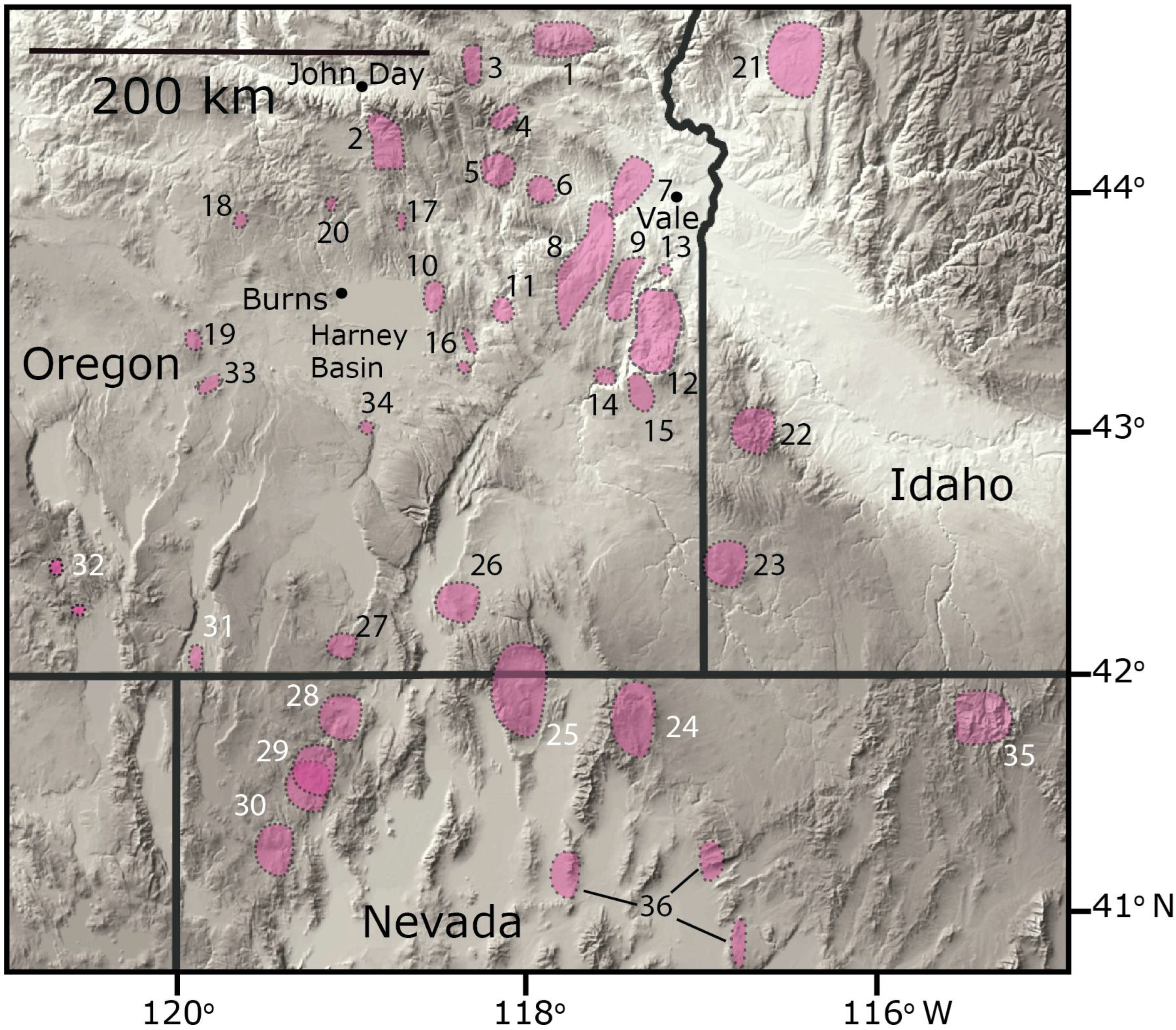
3.2. Ages of Other Mid-Miocene Silicic Centers
3.2.1. McDermitt Volcanic Field (25, 26 in Figure 4)
3.2.2. High Rock Caldera Complex (28–30 in Figure 4)
3.2.3. Hawks Valley–Lone Mountain Volcanic Field (27 in Figure 4)
3.2.4. Santa Rosa–Calico Volcanic Field (24 in Figure 4)
3.2.5. Juniper Mountain Complex (23 in Figure 4)
3.2.6. Silver City Range (22 in Figure 4)
3.2.7. Weiser Embayment Volcanic Field (21 in Figure 4)
3.2.8. Rhyolites of Bald Butte (32 in Figure 4), Drum Hill (32 in Figure 4), and Twenty Mile Creek (31 in Figure 4)
3.2.9. Mid-Miocene Dacites of the Harney Basin (33, 34 in Figure 4)
4. Discussion
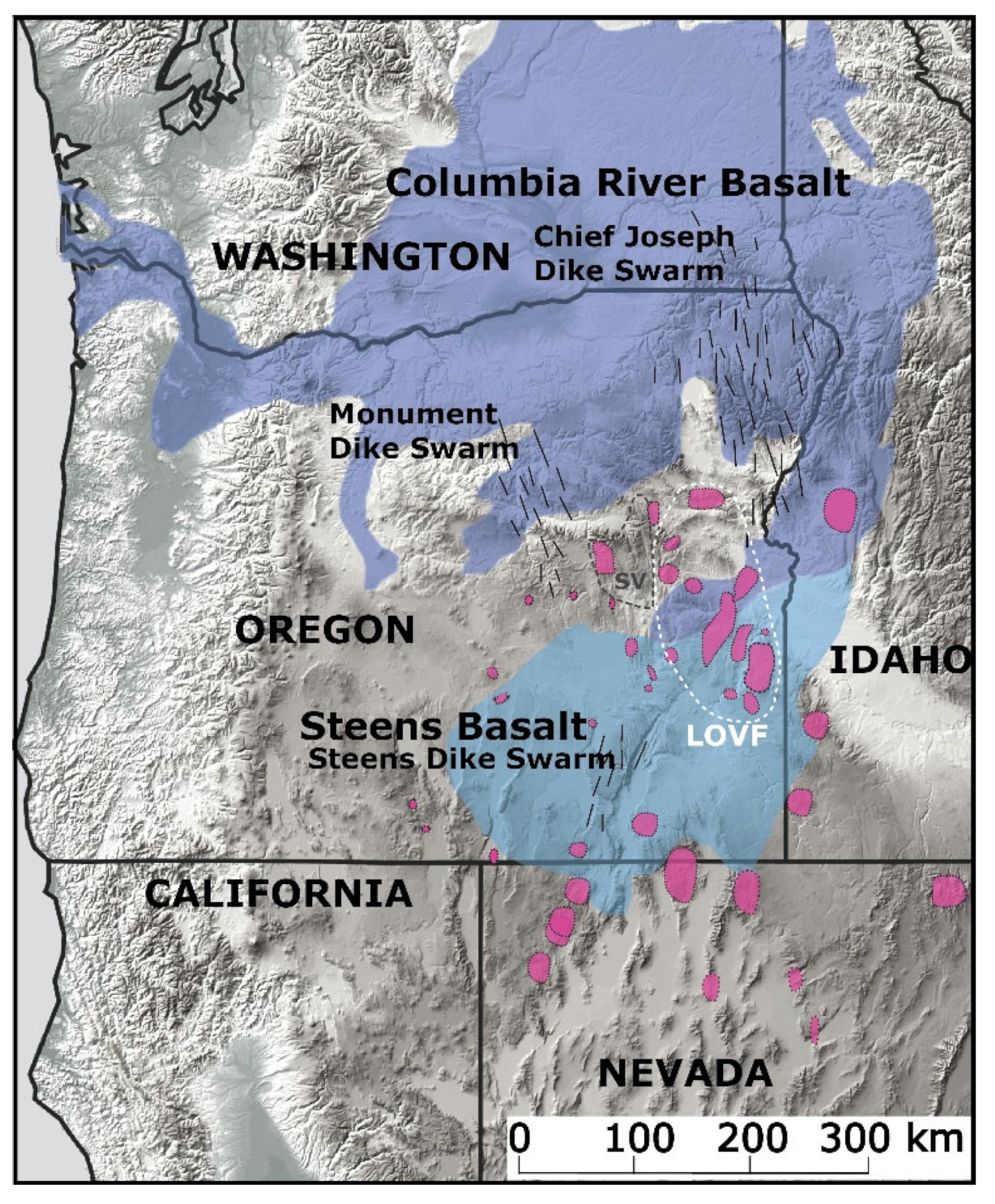
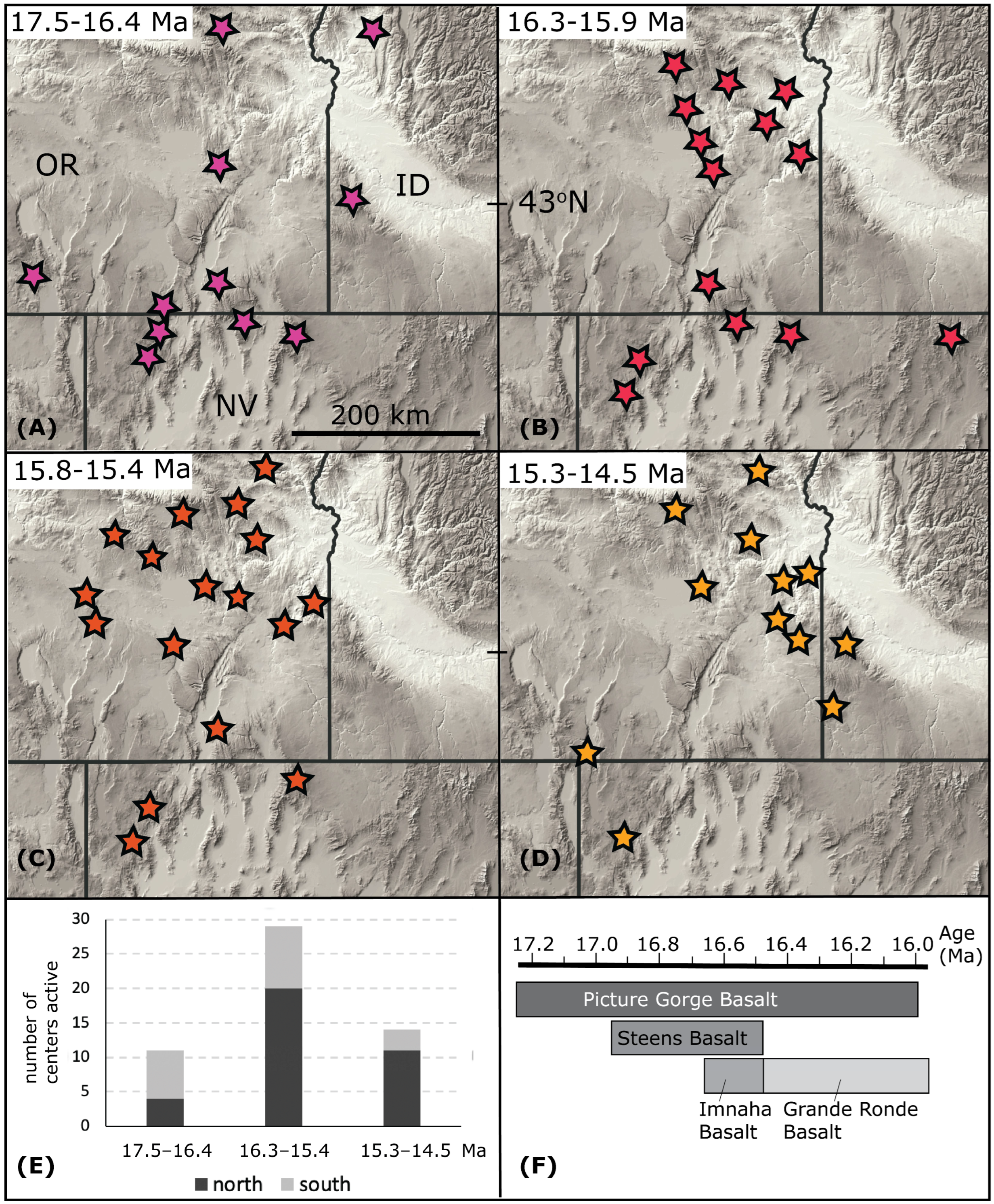
4.1. Distribution and Waxing and Waning of Columbia River Rhyolite Activity
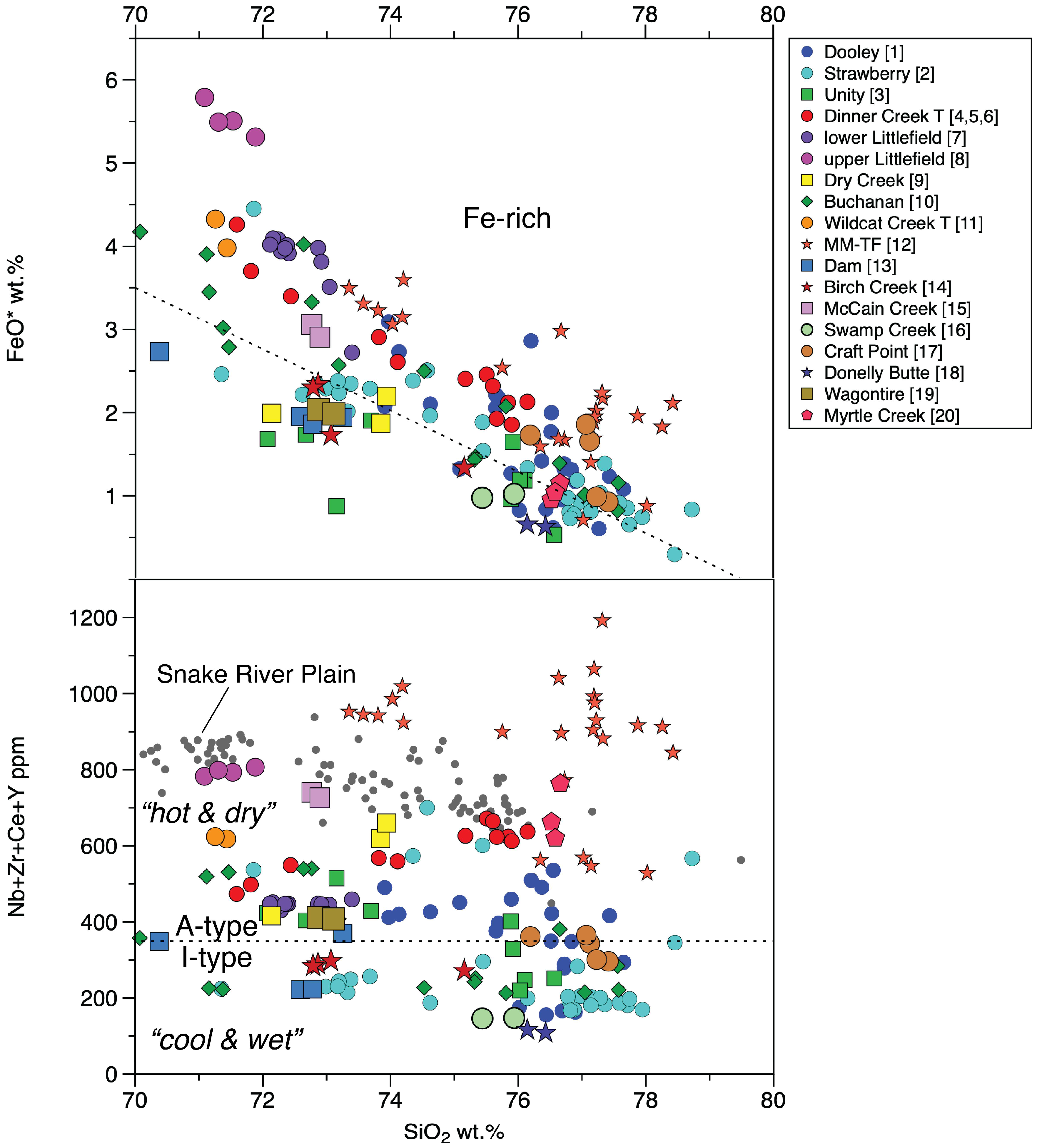
4.2. Mid-Miocene Rhyolites in Context to CRBG
4.3. Consequences of Arrival, Storage, and Dispersal of Columbia River Basalt Magmas
4.4. Consideration of Volume for Inferences of the Vigor of Basalt Magmatism
4.5. Implications for the Age-Progressive Snake River Plain–Yellowstone Rhyolite Trend and for the Pre-CRBG Hotspot Track
5. Conclusions
- There is no south-to-north age progression within the rhyolites, and the perceived progression was a result of an incomplete geochronological dataset of regional rhyolites. Consequently, the age progression interpreted in main CRBG units from south to north may simply be a function of where these eruptions occurred and not where mantle magmas were delivered.
- The rhyolite flare-up associated with CRBG volcanism covers a broad area and is focused significantly north of the McDermitt eruptive center and other earlier centers along the Oregon–Nevada state border.
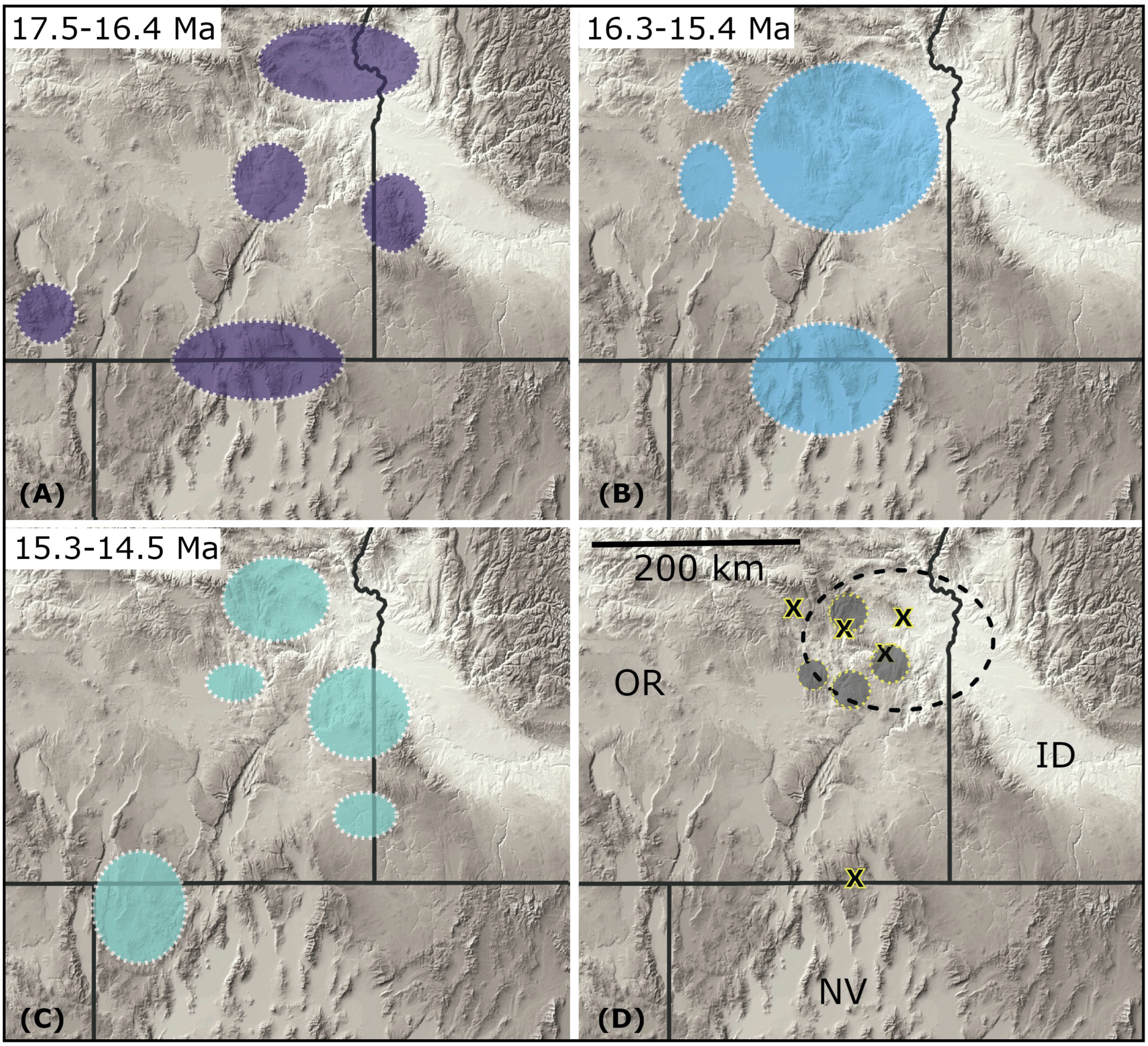
- Arrival of the thermal anomaly associated with flood basalts is essentially “instantaneous” across a circular area of 300–400 km, which seems to be best matched with the arrival of a mantle upwelling, irrespective of whether it was deep- or shallow-sourced.
- Distribution of rhyolites is well delimited in the west, north, and east, and this distribution likely reflects the extent of flood basalt reservoirs in the crust. Consequently, CRBG dikes of the Chief Joseph and Monument dike swarms located beyond these limits were likely not fed by magmas from crustal reservoirs located below the dikes. Rather, these swarms are keel dikes that were likely fed laterally from reservoirs residing within the footprint of the rhyolite distribution.
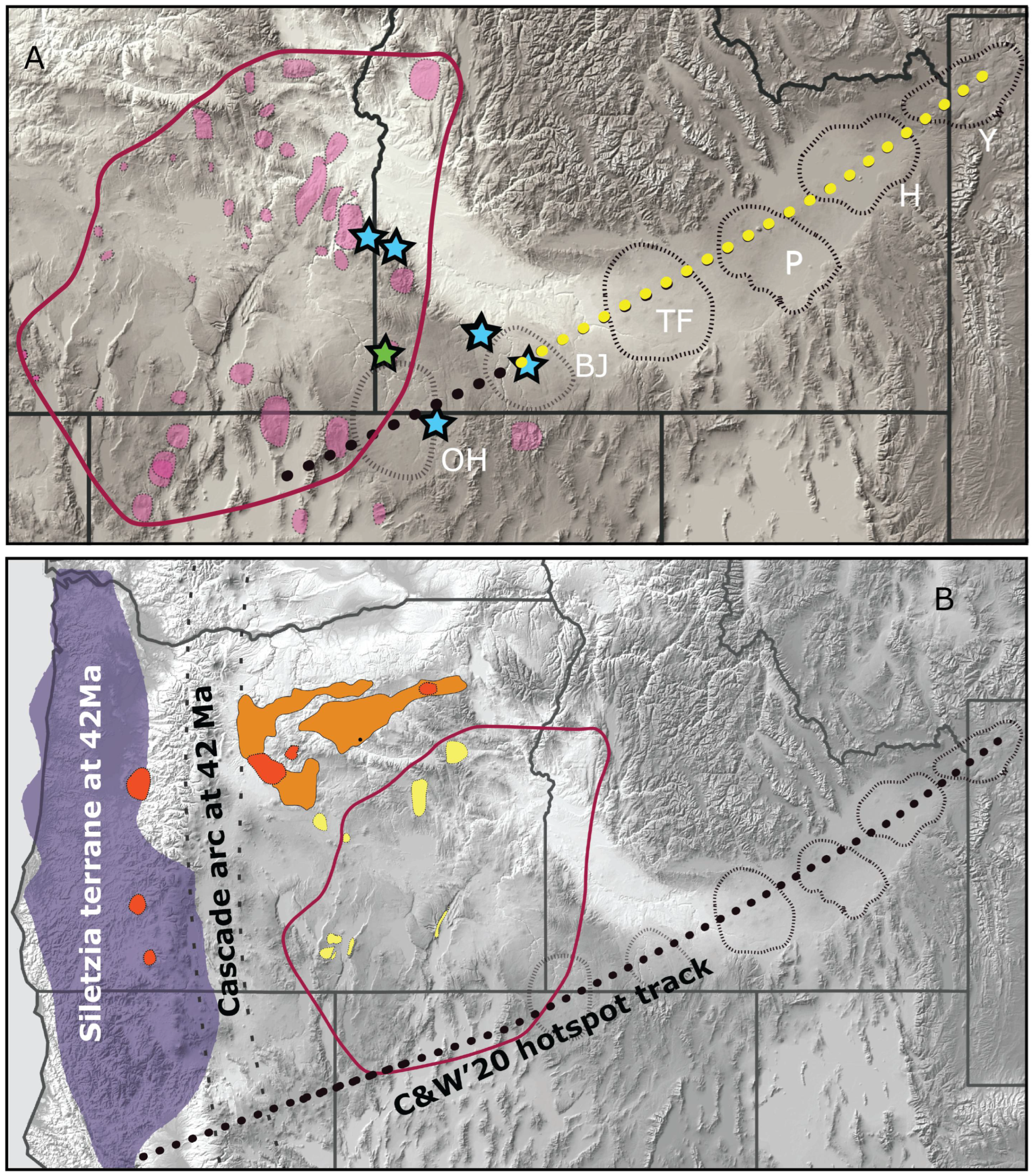
- The long-held view of McDermitt (and other early centers along the Oregon–Nevada state border) as the start of the age-progressive Snake River Plain trend (and which has been interpreted as hotspot track) must be revisited. Young Columbia River Rhyolites and younger centers suggest a more diffuse west–east migration starting farther north rather than a northeast migration from the McDermitt center. We suggest true age-progressive rhyolite volcanism paralleling plate motion of the North America plate started at the Bruneau-Jarbidge center from ~12 Ma onward towards Yellowstone.
Supplementary Materials
Author Contributions
Funding
Data Availability Statement
Acknowledgments
Conflicts of Interest
References
- White, R.S.; McKenzie, D. Magmatism at rift zones: The generation of volcanic continental margins and flood basalts. J. Geophys. Res. 1989, 94, 7685–7729. [Google Scholar] [CrossRef]
- White, R.S.; McKenzie, D. Mantle plumes and flood basalts. J. Geophys. Res. 1995, 100, 17543–17585. [Google Scholar] [CrossRef]
- Barry, T.L.; Kelley, S.P.; Reidel, S.P.; Camp, V.E.; Self, S.; Jarboe, N.A.; Duncan, R.A.; Renne, P.R. Eruption chronology of the Columbia River Basalt Group. In The Columbia River Flood Basalt Province: Geological Society of America Special Paper; Reidel, S.P., Camp, V.E., Ross, M.E., Wolff, J.A., Martin, B.S., Tolan, T.L., Wells, R.E., Eds.; Geological Society of America: Boulder, CO, USA, 2013; Volume 497, pp. 45–66. [Google Scholar]
- Bonnichsen, B.; Leeman, W.P.; Honjo, N.; McIntosh, W.C.; Godchaux, M.M. Miocene silicic volcanism in southwestern Idaho: Geochronology, geochemistry and evolution of the central Snake River Plain. Bull. Volcanol. 2008, 70, 315–342. [Google Scholar] [CrossRef]
- Camp, V.E.; Ross, M.E. Mantle dynamics and genesis of mafic magmatism in the intermontate Pacific Northwest. J. Geophys. Res. 2004, 109. [Google Scholar]
- Camp, V.E.; Ross, M.E.; Duncan, R.A.; Jarboe, N.A.; Coe, R.S.; Hanan, B.B.; Johnson, J.A. The Steens Basalt: Earliest lavas of the Columbia River Basalt Group. In The Columbia River Flood Basalt Province: Geological Society of America Special Paper; Reidel, S.P., Camp, V.E., Ross, M.E., Wolff, J.A., Martin, B.S., Tolan, T.L., Wells, R.E., Eds.; Geological Society of America: Boulder, CO, USA, 2013; Volume 497, pp. 87–116. [Google Scholar]
- Ferns, M.L.; McClaughry, J.D. Stratigraphy and volcanic evolution of the middle Miocene to Pliocene La Grande–Owyhee eruptive axis in eastern Oregon. In The Columbia River Flood Basalt Province: Geological Society of America Special Paper; Reidel, S.P., Camp, V.E., Ross, M.E., Wolff, J.A., Martin, B.S., Tolan, T.L., Wells, R.E., Eds.; Geological Society of America: Boulder, CO, USA, 2013; Volume 497, pp. 401–427. [Google Scholar]
- Hooper, P.R.; Binger, G.B.; Lees, K.R. Ages of the Steens and Columbia River flood basalts and their relationship to extension related calc-alkalic volcanism in eastern Oregon. Geol. Soc. Am. Bull. 2002, 114, 43–50. [Google Scholar] [CrossRef]
- Hooper, P.R.; Camp, V.E.; Reidel, S.P.; Ross, M.E. The origin of the Columbia River Flood Basalt province: Plume versus nonplume models. GSA Spec. Pap. 2007, 430, 635–668. [Google Scholar]
- Sawlan, M.; Hagstrum, J.T.; Wells, R.E. Geologic Mapping and Paired Geochemicalpaleomagnetic Sampling of Reference Sections in the Grande Ronde Basalt: An Example from the Bingen Section, Columbia River Gorge, Washington. In Proceedings of the Fall Meeting 2011, San Francisco, CA, USA, 5–9 December 2011; abstract #V13C-2605. American Geophysical Union: Washington, DC, USA, 2011. [Google Scholar]
- Wolff, J.A.; Ramos, F.C.; Hart, G.L.; Patterson, J.D.; Brandon, A.D. Columbia River flood basalts from a centralized crustal magmatic system. Nat. Geosci. 2008, 1, 177–180. [Google Scholar] [CrossRef]
- Jarboe, N.A.; Coe, R.S.; Renne, P.R.; Glen, J.M.G. The age of the Steens reversal and the Columbia River Basalt Group. Chem. Geol. 2010, 274, 158–168. [Google Scholar] [CrossRef]
- Fiebelkorn, R.B.; Walker, G.W.; MacLeod, N.S.; McKee, E.H.; Smith, J.G. Index to K-Ar Age Determinations for the State of Oregon; U.S. Geological Survey Open-File Report 82-0596; U.S. Geological Survey: Baltimore, MD, USA, 1982; 42p.
- Vander Meulen, D.B. Intracaldera Tuffs and Central-Vent Intrusion of the Mahogany Mountain Caldera, Eastern Oregon; U.S. Geological Survey Open-File Report 89-77; U.S. Geological Survey: Baltimore, MD, USA, 1989.
- Brueseke, M.E.; Hart, W.K.; Heizler, M.T. Diverse mid-Miocene silicic volcanism associated with the Yellowstone–Newberry thermal anomaly. Bull. Volcanol. 2008, 70, 343–360. [Google Scholar] [CrossRef]
- Camp, V.E.; Ross, M.E.; Hanson, W.E. Genesis of flood basalts and Basin and Range rocks from Steens Mountain to the Malheur River Gorge, Oregon. Geol. Soc. Am. Bull. 2003, 115, 105–128. [Google Scholar] [CrossRef]
- Matthew, A.; Mahood, G.A. Initial impingement of the Yellowstone plume located by widespread silicic volcanism contemporaneous with Columbia River flood basalts. Geology 2012, 40, 655–658. [Google Scholar]
- Cummings, M.L.; Evans, J.G.; Ferns, M.L.; Lees, K.R. Stratigraphic and structural evolution of the middle Miocene syn-volcanic Oregon-Idaho graben. Geol. Soc. Am. Bull. 2000, 112, 668–682. [Google Scholar] [CrossRef]
- Streck, M.J.; Ferns, M.L.; McIntosh, W. Large, persistent rhyolitic magma reservoirs above Columbia River Basalt storage sites: The Dinner Creek Tuff Eruptive Center, eastern Oregon. Geosphere 2015, 11, 226–235. [Google Scholar] [CrossRef]
- Bryan, S.E.; Riley, T.R.; Jerram, D.A.; Stephens, C.J.; Leat, P.T. Silicic volcanism: An undervalued component of the large igneous provinces and volcanic rifted margins. Geol. Soc. Am. Spec. Pap. 2002, 362, 99–120. [Google Scholar]
- Bryan, S.E.; Peate, I.U.; Peate, D.W.; Self, S.; Jerram, D.A.; Mawby, M.R.; Marsh, J.S.; Miller, J.A. The largest volcanic eruptions on Earth. Earth Sci. Rev. 2010, 102, 207–229. [Google Scholar] [CrossRef]
- Benson, T.R.; Mahood, G.A.; Grove, M. Geology and 40Ar/39Ar geochronology of the middle Miocene McDermitt volcanic field, Oregon and Nevada: Silicic volcanism associated with propagating flood basalt dikes at initiation of the Yellowstone hotspot. Geol. Soc. Am. Bull. 2017, 129, 1027–1051. [Google Scholar] [CrossRef]
- Brueseke, M.E.; Callicoat, J.S.; Hames, W.; Larson, P.B. Mid-Miocene rhyolite volcanism in northeastern Nevada: The Jarbidge Rhhyolite and its relationship to the Cenozoic evolution of the northern Great Basin (USA). Geol. Soc. Am. Bull. 2014, 126, 1047–1067. [Google Scholar] [CrossRef]
- Coble, M.A.; Mahood, G.A. New geologic evidence for additional 16.5–15.5 Ma silicic calderas in northwest Nevada related to initial impingement of the Yellowstone hotspot. Collapse Calderas Workshop. IOP Conf. Ser. Earth Environ. Sci. 2008, 3, 012002. [Google Scholar] [CrossRef]
- Henry, C.D.; Castor, S.B.; McIntosh, W.C.; Heizler, M.T.; Cuney, M.; Chemillac, R. Timing of Oldest Steens Basalt Magmatism from Precise Dating of Silicic Volcanic Rocks, McDermitt Caldera and Northwest Nevada Volcanic Field. In Proceedings of the Fall Meeting 2006, Boston, MA, USA, 27 November–3 December 2006; no. abstract #V44C-08. American Geophysical Union: Washington, DC, USA, 2006. [Google Scholar]
- Henry, C.D.; Castor, S.B.; Starkel, W.A.; Ellis, B.S.; Wolff, J.A.; Heizler, M.T.; McIntosh, W.C. The McDermitt Caldera, NV-OR, USA: Geologic Mapping, Volcanology, Mineralization, and High Precision 40Ar/39Ar Dating of Early Yellowstone Hotspot Magmatism; Fall Meeting 2012 abstract #V33B-2850; American Geophysical Union: Washington, DC, USA, 2012. [Google Scholar]
- Wolff, J.A.; Ramos, F.C. Source materials for the main phase of the Columbia River Basalt Group: Geochemical evidence and implications for magma storage and transport. In The Columbia River Flood Basalt Province: Geological Society of America Special Paper; Reidel, S.P., Camp, V.E., Ross, M.E., Wolff, J.A., Martin, B.S., Tolan, T.L., Wells, R.E., Eds.; Geological Society of America: Boulder, CO, USA, 2013; Volume 497, pp. 273–291. [Google Scholar] [CrossRef]
- Ernst, R.E.; Buchan, K.L. Giant radiating dyke swarms: Their use in identifying preMesozoic Large Igneous Provinces and mantle plumes. In Large Igneous Provinces: Continental, Oceanic and Planetary Flood Volansim; Mahoney, J.J., Coffin, M.F., Eds.; Geophys Monograph, SEG Library: Houston, TX, USA, 1997; Volume 100, pp. 297–333. [Google Scholar]
- Ernst, R.E.; Liikane, D.A.; Jowitt, S.M.; Buchan, K.L.; Blanchard, J.A. A new plumbing system framework for mantle plume-related continental Large Igneous Provinces and their mafic-ultramafic intrusions. J. Volcanol. Geotherm. Res. 2019, 384, 75–84. [Google Scholar] [CrossRef]
- Johnson, C.M. Large-scale formation and lithospheric modification beneath middle to late Cenozoic calderas and volcanic fields, western North America. J. Geophys. Res. 1991, 96, 1348513507. [Google Scholar]
- Christiansen, R.L.; Foulger, G.R.; Evans, J.R. Upper-mantle origin of the Yellowstone hotspot. Geol. Soc. Bull. 2002, 114, 1245–1256. [Google Scholar] [CrossRef]
- Fouch, M.J. The Yellowstone Hotspot: Plume or Not? Geology 2012, 40, 479–480. [Google Scholar] [CrossRef]
- Liu, L.; Stegman, D.R. Origin of the Columbia River flood basalt controlled by propagating rupture of the Farallon slab. Nature 2012, 482, 386–390. [Google Scholar] [CrossRef]
- Swenton, V.M.; Streck, M.J.; Miggins, D.P.; McIntosh, W.C. Filling critical gaps in the space-time record of High Lava Plains and co-Columbia River Basalt Group rhyolite volcanism. GSA Bull. 2022. [Google Scholar] [CrossRef]
- Pierce, K.L.; Morgan, L.A. Is the track of the Yellowstone hotspot driven by a deep mantle plume?—Review of volcanism, faulting, and uplift in light of new data. J. Volcanol. Geotherm. Res. 2009, 188, 1–25. [Google Scholar] [CrossRef]
- Glen, J.G.; Ponce, D.A. Large-scale fractures related to inception of the Yellowstone hotspot. Geology 2002, 30, 647–650. [Google Scholar] [CrossRef]
- Camp, V.E. Origin of Columbia River Basalt: Passive Rise of Shallow Mantle, or Active Upwelling of a Deep-Mantle Plume? In the Columbia River Flood Basalt Province: Geological Society of America Special Paper; Reidel, S.P., Camp, V.E., Ross, M.E., Wolff, J.A., Martin, B.S., Tolan, T.L., Wells, R.E., Eds.; Geological Society of America: Boulder, CO, USA, 2013; Volume 497, pp. 181–199. [Google Scholar]
- Pierce, K.L.; Morgan, L.A. The track of the Yellowstone hot spot: Volcanism, faulting, and uplift. Geol. Soc. Am. Mem 1992, 179, 1–52. [Google Scholar]
- Jordan, B.T.; Grunder, A.L.; Duncam, R.A.; Deino, A.L. Geochronology of age-progressive volcanism of the Oregon High Lava Plains: Implications for the plume interpretation of Yellowstone. J. Geophys. Res. 2004, 109, B10202. [Google Scholar] [CrossRef]
- MacLeod, N.S.; Walker, G.W.; McKee, E.H. Geothermal Significance of Eastward Increase in Age of Upper Cenozoic Rhyolitic Domes in Southeastern Oregon; U.S. Geological Survey Open-File Report 75-034, 1-21; Geological Society of America: Boulder, CO, USA, 1975. [Google Scholar]
- Geist, D.; Richards, M. Origin of the Columbia Plateau and Snake River plain: Deflection of the Yellowstone plume. Geology 1993, 21, 789–792. [Google Scholar] [CrossRef]
- Christiansen, E.H.; McCurry, M. Contrasting origins of Cenozoic silicic volcanic rocks from the western Cordillera of the United States. Bull. Volcanol. 2008, 70, 251–267. [Google Scholar] [CrossRef]
- Rytuba, J.J.; Vander Meulen, D.B. Hot-spring precious-metal systems in the Lake Owyhee volcanic field, Oregon-Idaho. In Geology and Ore Deposits of the Great Basin: Geological Society of Nevada Symposium Proceedings; Raines, G., Lisle, R.E., Schafer, R.W., Wilkinson, W.H., Eds.; Geological Society of America: Boulder, CO, USA, 1991; Volume 2, pp. 1085–1096. [Google Scholar]
- Walker, G.W. Revisions to the Cenozoic stratigraphy of Harney Basin, southeastern Oregon. U.S. Geol. Surv. Bull. 1979, 1475, 41. [Google Scholar]
- Noble, D.C.; Henry, C.D.; Park, S.L.; Smith, J.A.; Hausback, B.P.; Hilton, R.P. Geologic framework and evolution of the High Rock Canyon volcanic center, northwestern Nevada: An early caldera-focused system of the Yellowstone hotspot track. GSA Abstr. Programs 2009, 41, 57. [Google Scholar]
- Wypych, A.; Hart, W.; Scarberry, K.; McHugh, K.; Pasquale, S.A.; Legge, P.W. Geologic Map of the Hawks Valley–Lone Mountain Region, Harney County, Oregon; Oregon Department of Geology and Mineral Industries Open-File Report 0–11–12; Oregon Department of Geology and Mineral Industries: Portland, OR, USA, 2011; 28p. [Google Scholar]
- Eagar, K.C.; Fouch, M.J.; James, D.E.; Carlson, R.W. Crustal structure beneath the High Lava Plains of eastern Oregon and surrounding regions from receiver function analysis. J. Geophys. Res. 2011, 116, B02313. [Google Scholar] [CrossRef]
- Obrebski, M.; Allen, R.M.; Xue, M.; Hung, S.-H. Slab-plume interaction beneath the Pacific Northwest. Geophys. Res. Lett. 2010, 37, LI4305. [Google Scholar] [CrossRef]
- Shervais, J.W.; Hanan, B.B. Lithospheric topography, tilted plumes, and the track of the Snake River-Yellowstone hot spot. Tectonics 2008, 27, 2181. [Google Scholar] [CrossRef]
- Camp, V.E.; Wells, R.E. The Case for a Long-Lived and Robust Yellowstone Hotspot. GSA Today 2020, 31, 4–10. [Google Scholar] [CrossRef]
- Wells, R.; Bukry, D.; Friedman, R.; Pyle, D.; Duncan, R.; Haeussler, P.; Wooden, J. Geologic history of Siletzia, a large igneous province in the Oregon and Washington Coast Range: Correlation to the geomagnetic polarity time scale and implications for a long-lived Yellowstone hotspot. Geosphere 2014, 10, 692–719. [Google Scholar] [CrossRef]
- Stern, R.J.; Dumitru, T.A. Eocene initiation of the Cascadia subduction zone: A second example of plume-induced subduction initiation? Geosphere 2019, 15, 659–681. [Google Scholar] [CrossRef]
- Johnston, S.T.; Thorkelson, D.J. Continental flood basalts: Episodic magmatism above long-lived hotspots. Earth Planet Sci. Lett. 2000, 175, 247–256. [Google Scholar] [CrossRef]
- Large, A.M. Silicic volcanism at the northern and western extent of the Columbia River Basalt rhyolite flare-up: Rhyolites of Buchanan volcanic complex and Dooley Mountain volcanic complex, Oregon. Master’s Thesis, Portland State University, Portland, OR, USA, 2016; 190p. [Google Scholar] [CrossRef]
- Evans, G. Geologic Map of the Dooley Mounntain Quadrangle, Baker County, Oregon; US Geol Surv Geologic Quadrangle Ma GQ-1694; U.S. Geological Survey: Baltimore, MD, USA, 1992.
- Robyn, T.L. Geology and petrology of the Strawberry Mountain volcanic series, Central Oregon. Ph.D. Thesis, University of Oregon, Eugene, OR, USA, 1977. [Google Scholar]
- Steiner, A.; Streck, M.J. The Strawberry Volcanics: Generation of ‘Orogenic’ Andesites from Tholeiite within an Intra-Continental Volcanic Suite Centered on the Columbia River Flood Basalt Province, in Orogenic Andesites and Crustal Growth; Gómez-Tuena, A., Straub, S.M., Zellmer, G.F., Eds.; Geological Society, London, Special Publications: London, UK, 2013; Volume 385. [Google Scholar] [CrossRef]
- Dvorak, C.L.; Streck, M.J. Geologic Map of the Jump Off Joe Mountain Quadrangle, Oregon: U.S. Geological Survey EdMap, Scale 1:24,000, 1 Sheet. 2019; U.S. Geological Survey: Baltimore, MD, USA, 2019.
- Dvorak, C.L.; Streck, M.J. Geologic Map of the Big Canyon Quadrangle, Oregon: U.S. Geological Survey EdMap, Scale 1:24,000, 1 Sheet. 2020; Geological Survey: Baltimore, MD, USA, 2020.
- Cahoon, E.B.; Streck, M.J.; Ferns, M. Flood basalts, rhyolites, and subsequent volcanism of the Columbia River magmatic province in eastern Oregon, USA. In From Terranes to Terrains: Geologic Field Guides on the Construction and Destruction of the Pacific Northwest: Geological Society of America Field Guide; Booth, A.M., Grunder, A.L., Eds.; Geological Society of America: Boulder, CO, USA, 2021; Volume 62, pp. 301–352. [Google Scholar] [CrossRef]
- Brown, C.E.; Thayer, T.P. Geologic Map of the Canyon City Quadrangle, Northeastern Oregon: U.S. Geological Survey Miscellaneous Geologic Investigations Map I-447, scale 1:250,000.1967; Geological Survey: Baltimore, MD, USA, 1967.
- Dvorak, C.L. Distribution and Characterization of Rhyolites of the Strawberry Mountain Volcanics—Evolution of a Major rhyolite Field Associated with Columbia River Basalt Group Magmatism, Eastern Oregon, USA. Master’s Thesis, Portland State University, Portland, OR, USA, 2021; 195p. [Google Scholar] [CrossRef]
- Ford, M.T.; Grunder, A.L.; Duncan, R.A. Bimodal volcanism of the High Lava Plains and Northwestern Basin and Range of Oregon: Distribution and tectonic implications of ageprogressive rhyolites. Geochem. Geophys. Geosyst. 2013, 14, 2836–2857. [Google Scholar] [CrossRef]
- Whalen, J.B.; Currie, K.L.; Chappell, B.W. A-type granites: Geochemical characteristics, discrimination and petrogenesis. Contrib. Mineral. Petrol. 1987, 95, 407–419. [Google Scholar] [CrossRef]
- Reef, J.W. The Unity Reservoir Rhyodacite Tuff-Breccia and Associated Volcanic Rocks, Baker County, Oregon: Pullman. Master’s Thesis, Washington State University, Washington, DC, USA, 1983. Volume 1128. [Google Scholar]
- Greene, R.C.; Walker, G.W.; Corcoran, R.E. Geologic map of the Burns quadrangle. In U.S. Geological Survey Miscellaneous Geologic Investigations Map I-680, Scale 1:250,000, 1 Sheet 1972; Geological Survey: Baltimore, MD, USA, 1972. [Google Scholar]
- Piper, A.M.; Robinson, T.W.; Park, C.F.; Jessup, L.T. Geology and Groundwater Resources of the Harney Basin, Oregon, with a Statement on Precipitation and Tree Growth; U.S. Geological Survey Water-Supply Paper; Geological Survey: Baltimore, MD, USA, 1939; Volume 841, 223p.
- Wright, W.E.; Baisan, C.; Streck, M.; Wright, W.W.; Szejner, P. Dendrochronology and middle Miocene petrified oak: Modern counterparts and interpretation. Palaeogeogr. Palaeoclimatol. Palaeoecol. 2016, 445, 38–49. [Google Scholar] [CrossRef]
- Hess, E. Strontium, lead, and oxygen isotopic signatures of mid-Miocene silicic volcanism in eastern Oregon. Unpubl. Master’s Thesis, Portland State University, Portland, OR, USA, 2014; pp. 1–96. [Google Scholar]
- Steiner, A.; Streck, M.J. Voluminous and compositionally diverse, middle Miocene Strawberry Volcanics of NE Oregon: Magmatism cogenetic with flood basalts of the Columbia River Basalt Group. In Field Volcanology: A Tribute to the Distinguished Career of Don Swanson: Geological Society of America Special Paper; Poland, M.P., Garcia, M.O., Camp, V.E., Grunder, A., Eds.; Geological Society of America: Boulder, CO, USA, 2018; Volume 538, pp. 41–62. [Google Scholar] [CrossRef]
- Webb, B.M.; Streck, M.J.; McIntosh, W.C.; Ferns, M.L. The Littlefield Rhyolite and associated mafic lavas: Bimodal volcanism of the Columbia River magmatic province, with constraints on age and storage sites of Grande Ronde Basalt magmas. Geosphere 2018, 15, 60–84. [Google Scholar] [CrossRef]
- Marcy, P. Revisiting Volcanology and Composition of Rhyolites and Associated REE Rich Mafic Clasts of the Three Fingers Caldera, SE Oregon. Master’s Thesis, Portland State University, Portland, OR, USA, 2013; pp. 1–203. [Google Scholar]
- Black, C. Rhyolite Stratigraphy along Succor Creek: Insights into the Eruptive History of the Three Fingers and Mahogany Mountain Volcanic Field. Master’s Thesis, Portland State University, Portland, OR, USA, 2021; 158p. [Google Scholar]
- Jackson, A. New perspective on prolific and voluminous rhyolite volcanism of the Mahogany Mountain Three Fingers Rhyolite Field, eastern Oregon. Master’s Thesis, Portland State University, Oregon, Portland, 2021; 172p. [Google Scholar]
- Kittleman, L.R.; Green, A.R.; Haddock, G.H.; Hagood, A.R.; Johnson, A.M.; McMurray, J.M.; Russell, R.G.; Weeden, D.A. Geologic Map of the Owyhee Region, Malheur County, Oregon; Scale 1:125,000; University of Oregon Museum of Natural History Bulletin: University of Oregon: Eugene, OR, USA, 1967. [Google Scholar]
- Wood, J.D. The geology of the Castle Rock area, Grant, Harney and Malheur counties, Oregon. Master’s Thesis, Portland State University, Portland, OR, USA, 1976; pp. 1–123. [Google Scholar]
- Ferns, M.L.; Brooks, H.C.; Evans, J.G.; Cummings, M.L. Geologic map of the Vale 30’ x 60’ quadrangle, Malheur County, Oregon and Owyhee County, Idaho. In Oregon Department of Geology and Mineral Industries Geologic Map Series GMS-77, Scale 1:100,000; Oregon Department of Geology and Mineral Industries: Portland, OR, USA, 1993. [Google Scholar]
- Rytuba, J.J.; Minor, S.A.; McKee, E.H. Geology of the Whitehorse Caldera and Caldera-Fill Deposits, Malheur County, Oregon; U.S. Geological Survey Open-File Report 811092; Geological Survey: Baltimore, MD, USA, 1981; 19p.
- Hanna, T.R. Areal extent and volumes of the Dinner Creek Tuff units, eastern Oregon based on lithology, bulk rock composition and feldspar mineralogy. Master’s Thesis, Portland State University, Portland, OR, USA, 2018; 144p. [Google Scholar] [CrossRef]
- Cruz, M.; Streck, M.J. The Castle Rock and Ironside Mountain calderas, eastern Oregon, USA: Adjacent venting sites of two Dinner Creek Tuff units—The most widespread tuffs associated with Columbia River flood basalt volcanism. Geol. Soc. Am. Bull. 2022, 134, 2415–2435. [Google Scholar] [CrossRef]
- Sales, H.J. The Wildcat Creek Tuff, eastern Oregon: Co-eruption of crystal-poor rhyolite and Fe-rich andesite with implication for mafic underpinnings to voluminous A-type rhyolites. Master’s Thesis, Portland State University, Portland, OR, USA, 2018; 151p. [Google Scholar] [CrossRef]
- Lees, K.R. Magmatic and Tectonic Changes through Time in the Neogene Volcanic Rocks of the Vale Area, Oregon, Northwestern USA. Ph.D. Thesis, Open University, Milton Keynes, UK, 1994; pp. 1–283. [Google Scholar]
- Bonnichsen, B.; Kauffman, D.F. Physical features of rhyolite lava flows in the Snake. Geol. Soc. Am. Spec. Pap. 1987, 212, 119–145. [Google Scholar]
- Branney, M.J.; Bonnichsen, B.; Andrews, G.D.M.; Ellis, B.; Barry, T.L.; McCurry, M. ‘Snake River (SR)-type’ volcanism at the Yellowstone hotspot track: Distinctive products from unusual, high-temperature silicic super-eruptions. Bull. Volcanol. 2008, 70, 293–314. [Google Scholar] [CrossRef]
- Vander Meulen, D.B.; Rytuba, J.J.; Minor, S.A.; Harwood, C.S. Preliminary Geologic Map of the Three Fingers Rock quadrangle, Malheur County, Oregon. U.S. Geological Survey Open-File Report 89-344; U.S. Geological Survey: Baltimore, MD, USA, 1989. [Google Scholar]
- Vander Meulen, D.B.; Rytuba, J.J.; Vercoutere, T.L.; Minor, S.A. Geologic Map of the Rooster Comb 7.5’ Quadrangle, Malheur County, Oregon. U.S. Geological Survey Miscellaneous Field Studies Map, MF-1902C, scale 1:24,000; U.S. Geological Survey: Baltimore, MD, USA, 1987. [Google Scholar]
- Benson, T.R.; Mahood, G.A. Geology of the mid-Miocene Rooster Comb caldera and Lake Owyhee volcanic field, eastern Oregon: Silicic volcanism associated with Grande Ronde flood basalt. J. Volcanol. Geotherm. Res. 2016, 309, 96–117. [Google Scholar] [CrossRef]
- Kuiper, K.F.; Deino, A.; Hilgen, F.J.; Krijgsman, W.; Renne, P.R.; Wijbrans, J.R. Synchronizing rock clocks of earth history. Science 2008, 320, 500. [Google Scholar] [CrossRef] [PubMed]
- Feeney, D.M.; Isakson, V.H.; Lewis, R.S.; Mertzman, S.A. Mapping middle Miocene volcanic rocks in the Weiser Embayment, southwest Idaho: New U-PB Tims zircon age data. GSA abstract with programs. 2017. Available online: https://gsa.confex.com/gsa/2017AM/webprogram/Paper307041.html (accessed on 6 January 2023).
- MacLean, J.W. Geology and Geochemistry of Juniper Ridge, Horsehead Mountain and Burns Butte: Implications for the petrogenesis of silicic magmas on the High Lava Plains, southeastern Oregon. Master’s Thesis, Oregon State University, Corvallis, OR, USA, 1994; 141p. [Google Scholar]
- John, D.A. Miocene and early Pliocene epithermal gold-silver deposits in the Great Basin, western United States: Characteristics, distribution, and relationship to magmatism. Econ. Geol. 2001, 96, 1827–1853. [Google Scholar] [CrossRef]
- Wallace, A.R. Geology of the Ivanhoe Hg-Au district, northern Nevada: Influence of Miocene Volcanism, Lakes, and active faulting on epithermal mineralization. Econ. Geol. 2003, 98, 409–424. [Google Scholar] [CrossRef]
- Cruz, M.A.; Streck, M.J. Geologic Map of the Calamity Butte Quadrangle; Oregon: U.S. Geological Survey EDMAP project; U.S. Geological Survey: Baltimore, MD, USA, 2017.
- Isom, S.I.; Streck, M.J. Geologic Map of the Telephone Butte Quadrangle, Oregon: U.S. Geological Survey EDMAP project. 2016. Available online: https://ngmdb.usgs.gov/Prodesc/proddesc_109646.htm (accessed on 6 January 2023).
- Mathis, A.C. Geology and Petrology of a 26-Ma trachybasalt to Peralkaline Rhyolite Suite Exposed at Hart Mountain, Oregon. Master’s Thesis, Oregon State University, Corvallis, OR, USA, 1993; 141p. [Google Scholar]
- McClaughry, J.D.; Ferns, M.L.; Streck, M.J.; Patridge, K.A.; Gordon, C.L. Paleogene calderas of central and eastern Oregon: Eruptive sources of widespread tuffs in the John Day and Clarno Formations. In Volcanoes to Vineyards: Geologic Field Trips through the Dynamic Landscape of the Pacifi c Northwest: Geological Society of America Field Guide; O’Connor, J.E., Dorsey, R.J., Madin, I.P., Eds.; Geological Society of America: Boulder, CO, USA, 2009; Volume 15, pp. 407–434. [Google Scholar] [CrossRef]
- Meigs, A.; Scarberry, K.; Grunder, A.; Carlson, R.; Ford, M.T.; Fouch, M.; Grove, T.; Hart, W.K.; Iademarco, M.; Jordan, B.; et al. Geological and Geophysical Perspectives on the Magmatic and Tectonic Development, High Lava Plains and Northwest Basin and Range. In Volcanoes to Vineyards; Geological Society of America: Boulder, CO, USA, 2009. [Google Scholar]
- Cahoon, E.B.; Streck, M.J.; Koppers, A.A.P. Picture Gorge Basalt: Internal stratigraphy, eruptive patterns, and its importance for understanding CRBG magmatism. Geosphere 2023, 19, 1–25, in press. [Google Scholar]
- Moore, N.E.; Grunder, A.L.; Bohrson, W.A. The three-stage petrochemical evolution of the Steens Basalt (southeast Oregon, USA) compared to large igneous provinces and layered mafic intrusions. Geosphere 2018, 14, 2505–2532. [Google Scholar] [CrossRef]
- Cahoon, E.B.; Streck, M.J.; Koppers, A.A.; Miggins, D.P. Reshuffling the Columbia River Basalt chronology—Picture Gorge Basalt, the earliest-and longest-erupting formation. Geology 2020, 48, 348–352. [Google Scholar] [CrossRef]
- Reidel, S.P.; Tolan, T.L. The Grande Ronde Basalt, Columbia River Basalt Group. In The Columbia River Flood Basalt Province: Geological Society of America Special Paper; Reidel, S.P., Camp, V.E., Ross, M.E., Wolff, J.A., Martin, B.S., Tolan, T.L., Wells, R.E., Eds.; Geological Society of America: Boulder, CO, USA, 2013; Volume 497, pp. 117–153. [Google Scholar] [CrossRef]
- Kasbohm, J.; Schoene, B. Rapid eruption of the Columbia River flood basalt and correlation with the mid-Miocene climate optimum. Sci. Adv. 2018, 4, eaat8223. [Google Scholar] [CrossRef]
- Mahood, G.A.; Benson, T.R. Using 40Ar/39Ar ages of intercalated silicic tuffs to date flood basalts: Precise ages for Steens Basalt Member of the Columbia River Basalt Group. Earth Planet. Sci. Lett. 2017, 459, 340–351. [Google Scholar] [CrossRef]
- Townsend, M.; Huber, C.; Degruyter, W.; Bachmann, O. Magma chamber growth during intercaldera periods: Insights from thermo-mechanical modeling with applications to Laguna del Maule, Campi Flegrei, Santorini, and Aso. Geochem. Geophys. Geosyst. 2019, 20, 1574–1591. [Google Scholar] [CrossRef]
- Streck, M.J.; Grunder, A.L. Enrichment of basalt and mixing of dacite in the rootzone of a large rhyolite chamber: Inclusions and pumices from the Rattlesnake Tuff, Oregon. Contrib. Miner. Pet. 1999, 136, 193–212. [Google Scholar] [CrossRef]
- Beard, J.S.; Lofgren, G.E. Dehydration melting and watersaturated melting of basaltic and andesitic greenstones and amphibolites at 1, 3, and 6.9 kb. J. Petrol. 1991, 32, 365–401. [Google Scholar] [CrossRef]
- Leeman, W.P.; Whelan, J.F. Oxygen and Strontium Isotopic Studies of Basaltic Lavas from the Snake River Plain, Idaho; U.S. Geological Survey Open-File Report; Idaho Geological Survey: Moscow, ID, USA, 1983; Volume 83, 34p.
- Leeman, W.P.; Oldow, J.S.; Hart, W.K. Lithosphere-scale thrusting in the western U.S. Cordillera as constrained by Sr and Nd isotopic transitions in Neogene volcanic rocks. Geology 1992, 20, 63–66. [Google Scholar] [CrossRef]
- Manley, C.R.; McIntosh, W.C. The Juniper Mountain volcanic center, Owyhee County, southwestern Idaho: Age relations and physical volcanology. In Tectonic and Magmatic Evolution of the Snake River Plain Volcanic Province: Idaho Geological Survey Bulletin; Bonnichsen, B., McCurry, M., White, C.M., Eds.; Idaho Geological Survey: Moscow, ID, USA, 2002; Volume 30, pp. 205–277. [Google Scholar]
- Bonnichsen, B.; McCurry, M.; Godchaux, M. Miocene Snake River Plain rhyolites of the Owyhee Front, Owyhee count, Idaho. In Geological Field Trips in Southern Idaho, Eastern Oregon, and Northern Nevada, Boise; Haller, K.M., Wood, S.H., Eds.; U.S.G.S Open-File report posted on the internet in 2004; Department of Geosciences, Boise State University: Boise, ID, USA, 2004; pp. 155–173. [Google Scholar]
- Coats, R.L.; Hay, R.L.; Anderson, D.A. The Circle Creek Rhyolite, a volcanic complex in northern Elko county, Nevada. GSA Mem. 1968, 116, 69–100. [Google Scholar]
- Nash, B.P.; Perkins, M.E.; Christensen JNLee, D.-C.; Halliday, A.N. The Yellowstone hot in space and time: Nd and Hf isotopes in silicic magmas. Earth Planet. Sci. Lett. 2006, 247, 143–156. [Google Scholar] [CrossRef]


| Northern Sector (43o–45o N) This Study | Activity Phase, Ma | |||
|---|---|---|---|---|
| 17.5–16.4 | 16.3–15.9 | 15.8–15.4 | 15.3–14.5 | |
| Dooley Mountain (1) | ||||
| Strawberry (2) | ||||
| Unity (3) | ||||
| Ironside Mtn (4) | ||||
| Castle Rock (5) | ||||
| Source for Units 3 and 4 of Dinner Creek Tuff (6) | ||||
| Lower Littlefield (7) | ||||
| Upper Littlefield (8) | ||||
| Dry Creek (9) | ||||
| Buchanan and Buchanan tuff (10) | ||||
| Wildcat Creek tuff source (11) | ||||
| Mahogany Mountain—Three Fingers (12) | ||||
| Owyhee Dam “Dam” (13) | ||||
| Birch Creek (14) | ||||
| McCain Creek (15) | ||||
| Swamp Creek and Dome E of South Fork (16) | ||||
| Craft Point (17) | ||||
| Donnelly Butte (18) | ||||
| Wagontire Mountain (19) | ||||
| Myrtle Creek (20) | ??? | ??? | ||
| Literature | ||||
| Weiser (21) | ||||
| Silver City (22) | ||||
| Horsehead and Little Juniper Mountain (33) | ||||
| Jackass Butte (34) | ||||
| Southern Sector (43o–41o N) Literature | Activity Phase, Ma | |||
| 17.5–16.4 | 16.3–15.9 | 15.8–15.4 | 15.3–14.5 | |
| Juniper Mountain (23) | ||||
| Santa Rocsa—Calico (24) | ||||
| McDermitt (proper) (25) | ||||
| Whitehorse (McDermitt, N) (26) | ||||
| Hawks Valley (27) | ||||
| Virgin Valley (28) | ||||
| High Rock or Badger Mountain/Hanging Rock (29) | ||||
| Cottonwood Creek (30) | ||||
| Twelve Mile Creek (31) | ||||
| Drumhill and Bald Butte (32) | ||||
Disclaimer/Publisher’s Note: The statements, opinions and data contained in all publications are solely those of the individual author(s) and contributor(s) and not of MDPI and/or the editor(s). MDPI and/or the editor(s) disclaim responsibility for any injury to people or property resulting from any ideas, methods, instructions or products referred to in the content. |
© 2023 by the authors. Licensee MDPI, Basel, Switzerland. This article is an open access article distributed under the terms and conditions of the Creative Commons Attribution (CC BY) license (https://creativecommons.org/licenses/by/4.0/).
Share and Cite
Streck, M.J.; Swenton, V.M.; McIntosh, W.; Ferns, M.L.; Heizler, M. Columbia River Rhyolites: Age-Distribution Patterns and Their Implications for Arrival, Location, and Dispersion of Continental Flood Basalt Magmas in the Crust. Geosciences 2023, 13, 46. https://doi.org/10.3390/geosciences13020046
Streck MJ, Swenton VM, McIntosh W, Ferns ML, Heizler M. Columbia River Rhyolites: Age-Distribution Patterns and Their Implications for Arrival, Location, and Dispersion of Continental Flood Basalt Magmas in the Crust. Geosciences. 2023; 13(2):46. https://doi.org/10.3390/geosciences13020046
Chicago/Turabian StyleStreck, Martin J., Vanessa M. Swenton, William McIntosh, Mark L. Ferns, and Matt Heizler. 2023. "Columbia River Rhyolites: Age-Distribution Patterns and Their Implications for Arrival, Location, and Dispersion of Continental Flood Basalt Magmas in the Crust" Geosciences 13, no. 2: 46. https://doi.org/10.3390/geosciences13020046
APA StyleStreck, M. J., Swenton, V. M., McIntosh, W., Ferns, M. L., & Heizler, M. (2023). Columbia River Rhyolites: Age-Distribution Patterns and Their Implications for Arrival, Location, and Dispersion of Continental Flood Basalt Magmas in the Crust. Geosciences, 13(2), 46. https://doi.org/10.3390/geosciences13020046