Article

Best Practices for Developing Geotechnical Models and Seismic Hazard Procedures for Critical Infrastructure: The Viadotto Italia Case Study in Southern Italy

by
Ernesto Ausilio
1,*,
Maria Giovanna Durante
1 and
Paolo Zimmaro
2,3
1
Department of Civil Engineering, University of Calabria, 87036 Arcavacata di Rende, Italy
2
Department of Environmental Engineering, University of Calabria, 87036 Arcavacata di Rende, Italy
3
Department of Civil and Environmental Engineering, University of California, Los Angeles, CA 90095, USA
*
Author to whom correspondence should be addressed.
Geosciences 2022, 12(8), 295; https://doi.org/10.3390/geosciences12080295
Submission received: 1 July 2022 / Revised: 23 July 2022 / Accepted: 27 July 2022 / Published: 29 July 2022
(This article belongs to the Collection New Advances in Geotechnical Engineering)

Abstract

:
The performance of a large number of critical infrastructure systems needs to be periodically re-evaluated. This is especially so when such systems are located in seismic areas and are subjected to ageing effects. Seismic re-evaluations are typically performed using numerical response history analyses based on a geotechnical model of the infrastructure and using hazard-consistent ground motions. We depart from the Viadotto Italia (the tallest multi-span bridge in Italy, located in a high-seismicity region) to draw best practices on how to construct a robust geotechnical model and derive appropriate target response spectra to be used in forward applications. Our proposed framework starts with the analysis of historical and new information and data. We then describe how to perform a multi-epoch consistency analysis that deals with the reliability and level of uncertainty of the data, culminating with the definition of a pragmatic geotechnical model that builds upon all available data, including investigation information produced at different spatial resolutions and quality levels. We also propose a consistent approach to perform site-specific probabilistic seismic hazard analysis to develop appropriate ground motions. This last step builds upon experiences with a data-rich high-seismicity zone in southern Italy, where both shallow crustal faults and deep subduction sources are present.

1. Introduction

Geotechnical site characterization data along with site-specific seismic hazard assessments are very important pieces of information to evaluate the seismic performance of important structures and/or infrastructure systems. Such analyses can be conducted by means of reduced- or full-scale testing or using numerical approaches. Numerical models include response history analyses, which can only be calibrated if a reliable geological-geotechnical-structural model is defined and input ground motions are consistent with the hazard of the area. The former is ideally derived from geotechnical/geophysical site characterization data, combined with geological information. The latter should be based on site- and structure-specific deterministic or probabilistic seismic hazard analyses (DSHA and PSHA, respectively). Through the lens of a unique and well-documented case study (Italy’s tallest multi-span bridge: the Viadotto Italia), we present best practices for geotechnical site characterization and site-specific PSHA for critical infrastructure systems.
The presented framework is particularly relevant as, especially in Western countries, most infrastructure systems were built after the Second World War and are now ageing and/or require seismic re-analysis. As a result, current challenges in merging data from different epochs and with variable levels of resolution and quality need to be faced by adopting a reliable and repeatable approach. There is an existing body of literature on this matter (e.g., [1] for dams; [2,3] for bridge sites). However, most studies have focused on new data and have not attempted to reconcile historical information and data and new geological-geotechnical characterization programs. Furthermore, such site characterization strategies and programs are often analyzed in isolation, without any consideration of their potential ties with site-specific PSHA studies. In this study, we illustrate and critically analyze the results of a historical review of available geotechnical site characterization data collected before, during, and after the construction of the Viadotto Italia. We then illustrate how to build a coherent geotechnical model for use in numerical response history analyses combining such historical information with additional data obtained more recently as part of an investigation program performed in 2015.
The analysis performed and illustrated in this study is particularly challenging because of three main reasons: (1) it involves a complex geologic setting and a deep canyon, making it hard to perform geotechnical/geophysical investigation studies; (2) the infrastructure being analyzed is a long multi-span bridge crossing multiple geologic units; and (3) the area is interested by both shallow crustal and deep subduction seismicity and by the presence of many tectonic discontinuities. As a result, the robustness of a numerical model constructed to analyze the seismic response of this infrastructure system heavily relies upon a reliable and detailed geotechnical model. The main goal of this study is twofold: (1) to provide a step-by-step procedure by which a robust geotechnical model can be derived for similar distributed infrastructure located in challenging geological, geotechnical, and tectonic settings; and (2) to gain insights into site-specific PSHA for critical infrastructure systems in high-seismicity areas. We depart from the Viadotto Italia case study to provide general and globally applicable insights into both issues. We anticipate that the availability of the framework presented here will be useful for future studies on critical infrastructure systems in seismic-prone areas. This is particularly relevant, in light of earthquake-induced damage to critical infrastructure, including transportation systems observed during recent earthquakes, e.g., [4,5,6,7,8,9].

2. The Viadotto Italia Case Study

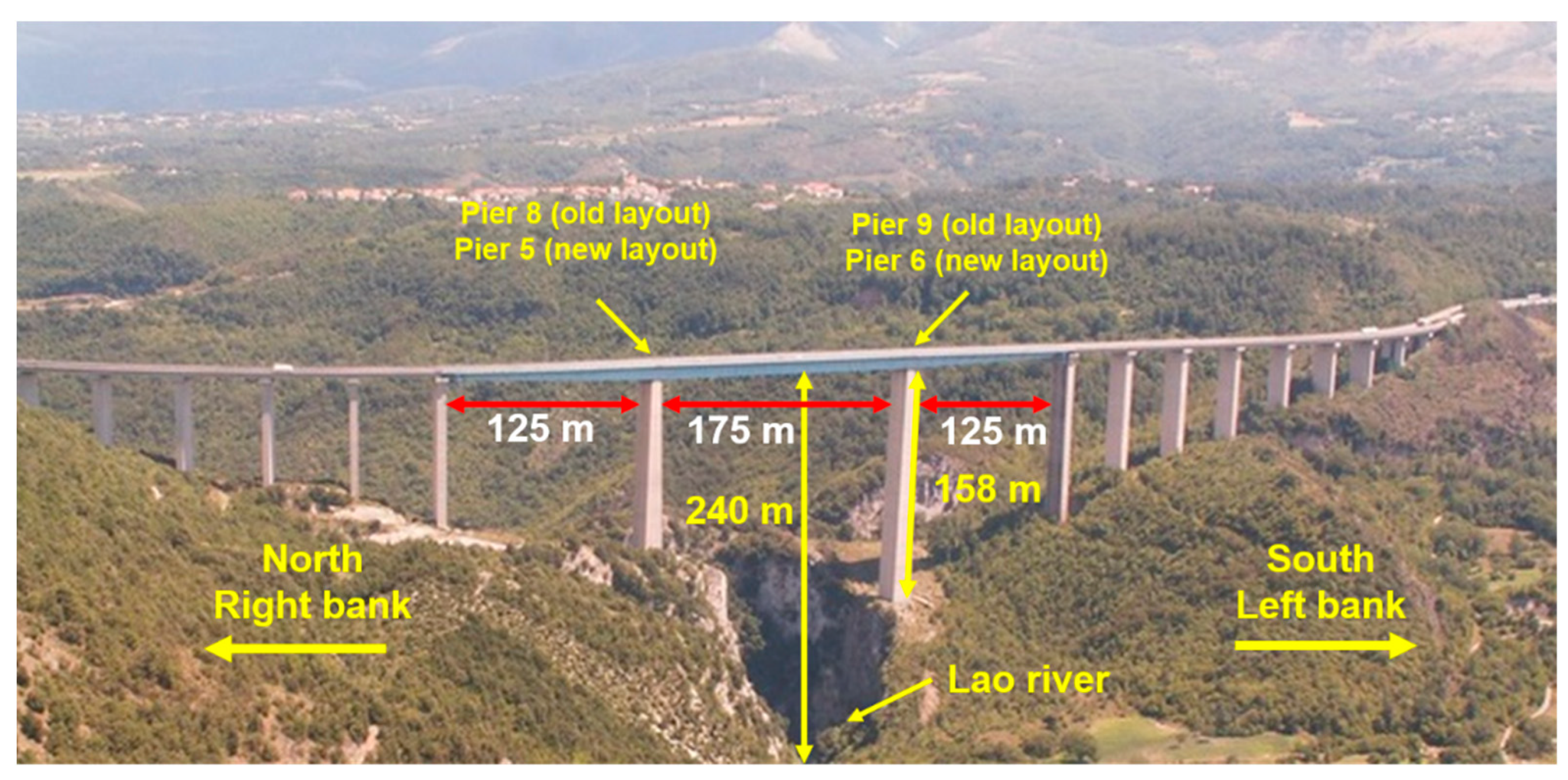
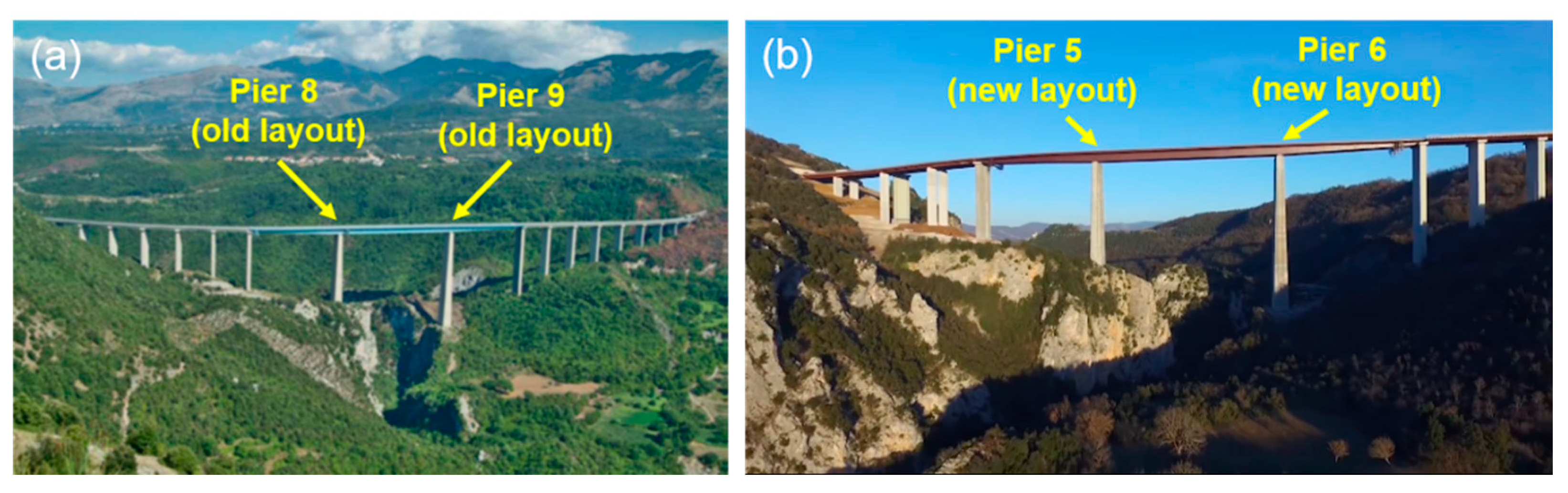
2.1. Historical Overview and Geometrical and Technical Background of the Construction of the Viadotto Italia Case Study

The Viadotto Italia is the second tallest multi-span bridge in Europe and the tallest in Italy (Figure 1). It is located near the town of Laino Borgo (northern Calabria, southern Italy) along the A2 Mediterranean highway (Autostrada del Mediterraneo), which connects Salerno to Reggio Calabria. This multi-span bridge is a critical infrastructure that was designed in the 1960s and built by Lodigiani General Contractors for the National Autonomous Roads Corporation (Azienda Nazionale Autonoma delle Strade, ANAS) between 1966 and 1969 [10]. It is 1161 m long and at the time of construction had 19 spans, 17 piers, and 2 abutments. Its central portion crosses the Lao river canyon and has a height of 240 m. It comprises three central steel spans that are 125, 175, and 125 m long, respectively. The central part of the bridge is connected to the rest of the structure by means of curved pre-stressed concrete spans. All piers have hollow sections and are tapered along their height [11]. The foundations of all piers are shallow and were built by excavating the shallowest portion of the outcropping rocks and locally consolidating these fractured rocks with low-pressure cement injections and using strand steel anchors.

2.2. The 2014 Renovation of the Viadotto Italia

In 2014, the bridge was renovated to upgrade its safety standards and make them consistent with more modern provisions. The renovation process lasted more than two years and was completed in 2016. As a result of this renovation process, the central part of the bridge was kept as is while the curved parts were substituted by straight spans. Furthermore, the original pre-stressed central concrete span was substituted with a weathering steel span. Because of these changes, the number and the position of some piers changed over the years [11]. The two central piers did not change position but their IDs changed. They were called piers 8 and 9 in the old layout and are now called piers 5 and 6 in the new layout (Figure 1 and Figure 2). A comparison between the two layouts is shown in Figure 2.

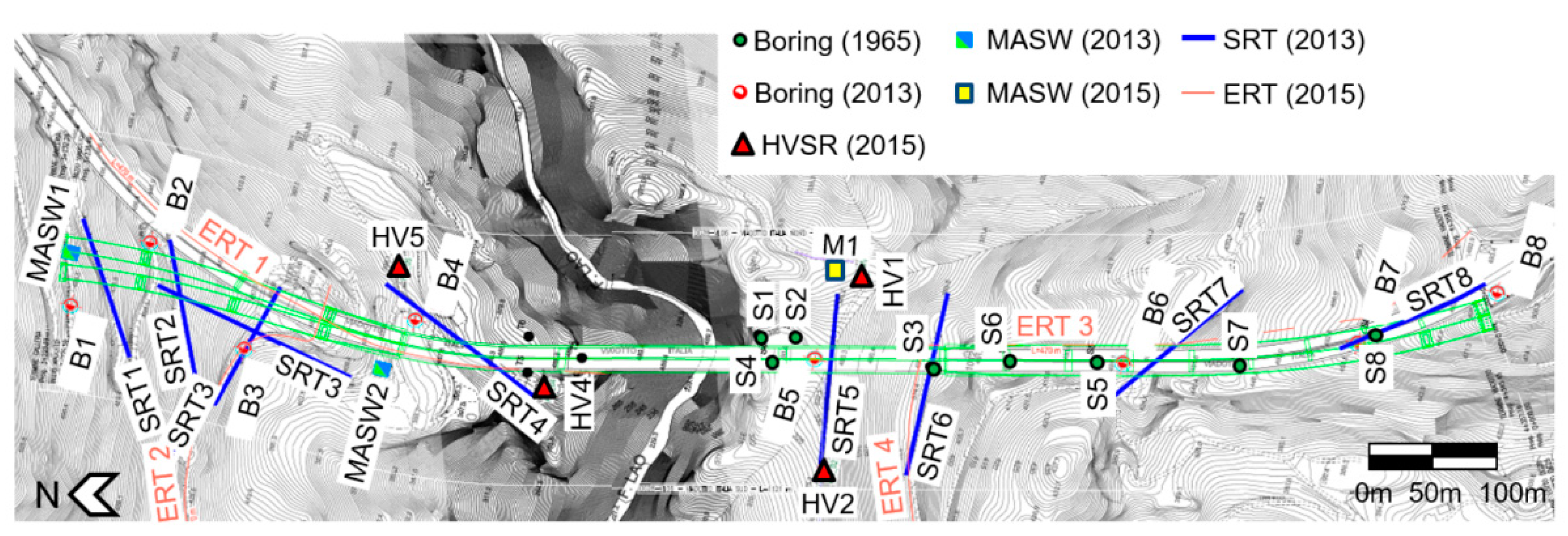
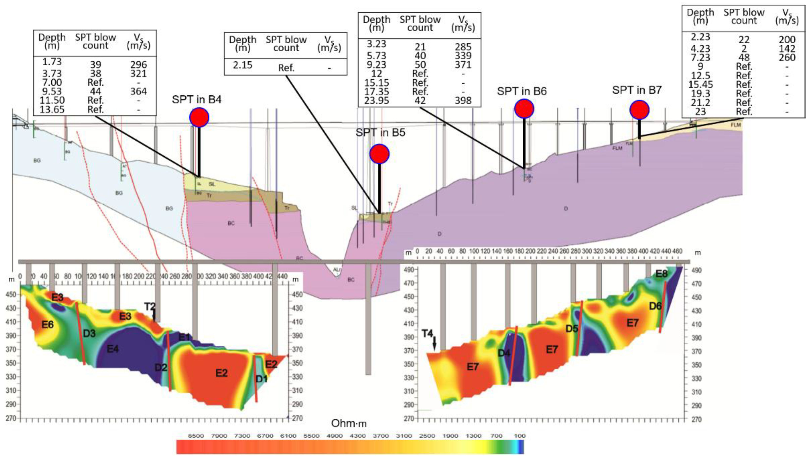
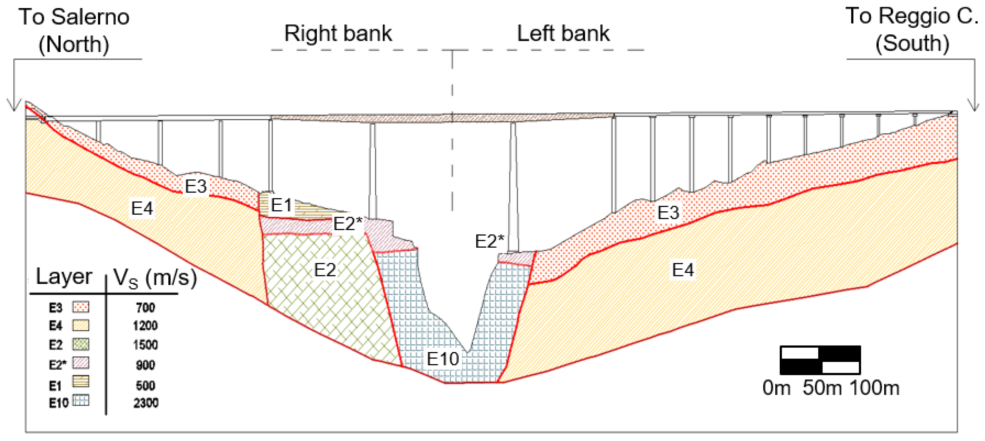
3. Geotechnical Model of the Viadotto Italia Site

In this paper, data from various geological, geotechnical, and geophysical investigation programs was collected, analyzed, and summarized to obtain a final geotechnical model to be used in numerical response history analyses. The following sources were geotagged and digitized and are summarized in the remainder of this section (Figure 3):
  • Data from 14 boring logs with depths ranging from 46–50 m performed in 1965 by Geosonda s.r.l. for ANAS (labeled as Sx, where x is the boring number in Figure 3) [12]. These borings were all drilled along the construction route;
  • Geophysical test results performed by Compagnia Mediterranea Prospezioni Roma in 1965 for ANAS [12]. This data was obtained using a rather rudimentary geophysical prospection approach and was not used in this study;
  • Data from boring logs (labeled as Bx, where x is the boring number in Figure 3), with standard penetration tests (SPTs), flat dilatometer tests, and pressuremeter tests performed on various samples along the borings, and Lugeon permeability tests when such measurement was deemed to be possible in fractured rock. These tests were performed by Trivel Sondaggi s.r.l. (a sub-contractor of the general contractor Italsarc Scpa) for ANAS in 2013. This data was used to guide the upcoming renovation process, which started in 2014. A total of seven of these borings are shown in Figure 3 and are located in the central portion of the bridge (crossing the Lao river canyon);
  • Geophysical test results, including multichannel analysis of surface waves (MASW) and seismic refraction tomography (SRT) tests performed by IdroGeo s.r.l. (a sub-contractor of the general contractor Italsarc Scpa) for ANAS in 2013; and
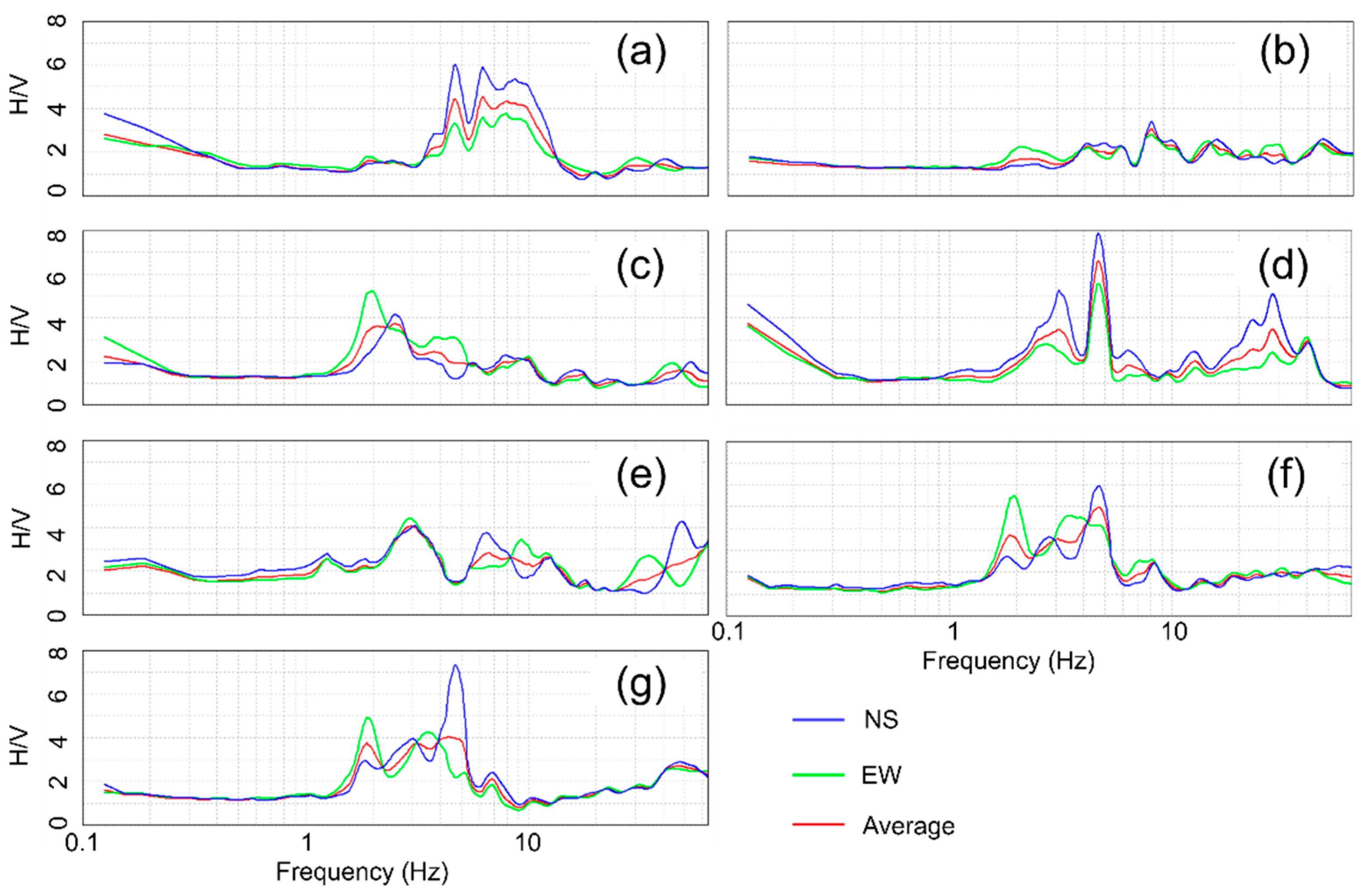
  • Non-invasive geophysical test results, including one MASW (labeled as M1 in Figure 3), electrical resistivity tomography (ERT) tests, microtremor-based horizontal-to-vertical spectral ratio (HVSR) analysis, and refraction microtremor (ReMi) tests performed by the University of Calabria in collaboration with the Italian Research Council in 2015 as part of the research presented herein [13,14].
The first step toward the construction of a reliable geotechnical model was to assess the quality of the data obtained from each investigation program. This step involved reading and critically analyzing each investigation report. Historical sources may be retrieved from design documents, construction logs, and technical reports. Such information is not often readily available and may include documents that are part of the gray literature. Most of the data gathered in this study was used to build the model presented at the end of this section. However, some geophysical data collected in 1965 was deemed to be unreliable and was not used. Such a decision was made after learning that the procedure adopted to collect the data was rather rudimentary and the resulting data was produced at a spatial resolution that was too low to be used for the purpose of building a geotechnical model. Once all of the data was collected and analyzed, the non-digital data (mainly from old investigations) had to be digitized and geotagged to be put in a geographic information system (GIS) software tool. This step is unavoidable and involves an accurate analysis of any landmarks in the area with known coordinates. Up to ten known points were used to reliably geotag each test location. The resulting GIS-based investigation map is shown in Figure 3.

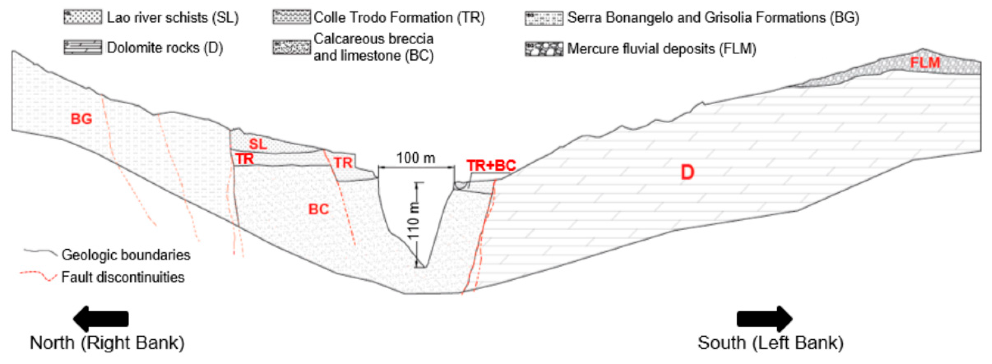
3.1. Geology of the Area

The study area is located in the northern sector of the Calabria region, close to the border with the Basilicata region (immediately north of Calabria). This zone is in the south-west portion of the Mercure Basin, which is located within a tectonic discontinuity (the Mt. Pollino area) that was filled during the Quaternary with fluvial and lacustrine deposits [12,15]. This area is crossed by the roughly east–west Pollino fault zone and is characterized by the presence of the following Mesozoic carbonatic units that are typical of the Mt. Pollino area: limestone, dolomitic limestone, and dolomite. Moving from older to more surficial units, the succession includes calcarenites and intercalations of Cretaceous dolomitic limestones. The Mesozoic rocks are then covered by coarse-grained greyish calcarenites (part of the Cerchiara Formation, [16]) attributed to a Miocenic transgression, followed by Flysch deposits with a high clay content (part of the Bifurto formation). These formations are in turn thrusted by Triassic dolomite rocks [15].
The whole area is characterized by an intense active seismicity. As a result of this tectonic activity, all geologic formations in the Lao river valley are intensely fractured. Contacts between geologic units comprise cataclastic and mylonitic bands often re-transformed by metamorphic and/or karst processes. Such processes are particularly relevant in the Cretaceous limestones on the left bank of the valley. On the other hand, the Triassic dolomite rocks are characterized by the presence of fissures and cavities filled with more recent materials. Figure 4 shows a synthetic geologic cross-section of the Lao river valley, reporting the main units and tectonic discontinuities. Such a cross-section will form the basis for the final geotechnical model that will be derived from merging geologic information with geotechnical and geophysical data. The main units reported in Figure 4 are the following:
  • Lao river schists (SL): greyish to greenish argillites with thin layers of quartzite;
  • Dolomite rocks (D): gray to black dolomites with medium-to-fine grains;
  • Colle Trodo Formation (TR): gray to dark blue calcareous breccia and limestone alternated with silty clays, marly limestone, and marly varicolored clays;
  • Calcareous breccia and limestone (BC): gray compact microcrystalline limestone intercalated with sedimentary carbonatic breccia and carbonatic cobbles;
  • Serra Bonangelo and Grisolia Formations (BG): indistinguishable formations comprising gray to black micritic limestone and thin layers of limestone intercalated with red and yellow marls and compact and stratified dolomitic limestone;
  • Mercure fluvial deposits (FLM): gravelly to sandy fluvial deposits with thin layers of fine-grained lacustrine material.

3.2. Geotechnical/Geophysical Characterization and Geotechnical Model of the Site

This sub-section summarizes available geotechnical/geophysical characterization data and discusses similarities and differences between co-located tests performed at different points in time. Such multi-epoch consistency analysis is very important to identify ranges of variability (i.e., that can be treated as aleatory variability components) and/or site characterization gaps, which can be solved with additional measurements (i.e., that should be considered as sources of epistemic uncertainty).
The 2015 University of Calabria test program included various ERTs. ERT tests were successfully used by Ausilio and Zimmaro [18] to map mechanical discontinuities in fractured and altered rock formations in the Calabria region. As a result, such tests were performed to achieve two goals (and to fill gaps present in the historical data): (1) verify and identify the location of tectonic discontinuities, and (2) characterize the horizontal and vertical spatial variation of the materials present along the bridge and under each pier. Figure 5 shows the cross-section of the Lao river valley and the results from ERT1 and ERT3 (roughly aligned with the bridge route in this area; see Figure 3 for the location of all ERTs). Figure 5 also shows the geologic model provided in Figure 4 to provide a direct side-by-side comparison between geological information and geophysical data. By critically analyzing ERT1, it is possible to identify three major discontinuities that should be related to tectonic features. This information is consistent with the geologic information available prior to performing this test. Such tectonic discontinuities create a clear boundary between the Lao river schists (SL) and Colle Trodo Formation (TR) to the north of the valley, also highlighting a substantial sub-vertical offset of the BC geologic unit. ERT3 shows some clear sub-vertical resistivity contrasts that point towards tectonic/geologic discontinuities. However, according to all available boring logs (both from 1965 and 2013), these discontinuities did not produce substantial heterogeneity in the materials present in this area. Such lack of along-the-bridge lateral variability is consistent with geologic information. Interestingly, borings S2 and S4 drilled in 1965 and B5 drilled in 2013 are roughly co-located and provide very consistent stratigraphic logs with a thin layer of sandy silt overlying dolomitic calcareous rock formations (unit D in Figure 4 and Figure 5). This multi-epoch consistency analysis was performed for other co-located borings, showing good agreement between boring logs produced in 1965 and 2013. Such consistency makes the final geotechnical model more robust and minimizes the need for the introduction of epistemic uncertainties in the analysis.
Figure 5 also shows the location where four borings were SPT were performed. Blow count data and shear wave velocity (VS) profiles obtained from the well-known empirical SPT–VS relationship of Ohta and Goto [19] are in good agreement with the ERT data, showing lower blow counts in the shallowest layers of the left bank of the valley, followed by refusal in deeper layers. Such consistency between the SPT blow counts and ERT data is also evident in B4 (right bank of the valley), where the Lao river schists overly the Colle Trodo Formation materials. The VS profiles obtained using MASW analyses also provide confirmation about the goodness of the stratigraphic layering obtained using geologic, geophysical, and geotechnical data.
Figure 6 shows the HVSR results for all seven locations where such non-invasive noise-based tests were performed in 2015. HV1, HV2, HV3, HV6, and HV7 were performed on the left bank of the valley (with HV1 and HV2 closer to the bridge) while HV4 and HV5 were both performed in the vicinity of the bridge on the right bank of the valley. HV1, HV4, HV6, and HV7 all show a pretty narrow peak at ~4.5 Hz. Such peaks may be due to impedance contrasts located at around 15–20 m from the surface. HV3, HV4, HV5, HV6, and HV7 all show peaks in the range 2–3 Hz. This peak range may be related to the impedance contrast between shallower rocks and the deeper bedrock layer (possibly extending at or below 80 m from the surface—horizon at which VS values reach 2000 m/s).
The final geotechnical model that we believe can be reliably adopted to perform forward numerical response history analyses is shown in Figure 7. This geotechnical model represents a compromise between more detailed information that can be derived from location-specific tests (i.e., borings, MASW, and SPT) and spatially distributed data and/or interpretations derived using the ERT and SRT results. Since the single most important input parameter in a numerical model is the shear modulus (which is in turn related to the VS), the final geotechnical model shown in Figure 7 contains homogeneous VS values for each “seismo-layer” being identified. The most important difference between the stratigraphic layering identified in Figure 4 (mostly based on geologic information) and that presented in Figure 7 pertains to the shallower material on the left bank (E3 in Figure 7) overlaying the stiffer E4 layer comprising dolomite rocks. This two-layer approach on this side of the valley was adopted by merging ERT data with the higher-resolution boring logs described above. All major tectonic discontinuities identified are included in the model. Particular attention should be devoted to such discontinuities when building a numerical model as tectonic features, in addition to stratigraphic and topographic effects, may alter wave propagation paths.

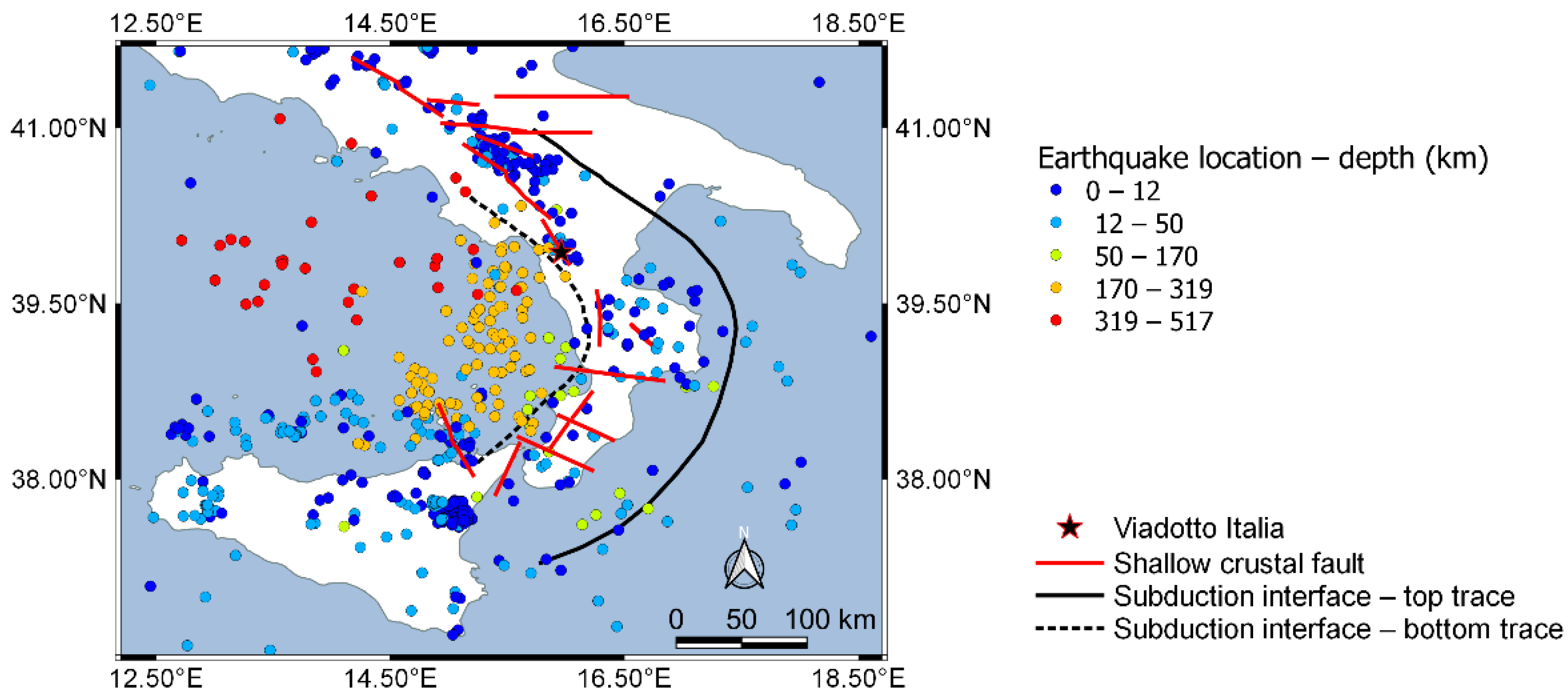
4. Site-Specific PSHA for the Viadotto Italia Site

When performing the analysis of the seismic behavior of a civil structure and/or infrastructure system, the seismic demands to which it could be expected to be subjected in future earthquakes should be identified. Demand evaluation relies upon DSHA and/or PSHA results [20,21]. PSHA are preferred for such applications for various reasons, including the following [22]: (1) they preserve information on the uncertainties involved in the process, (2) return periods produced by PSHA have a clear meaning while deterministic analysis involves an arbitrary pre-selection of earthquake events and ground motion percentiles (the details of which are often obfuscated), and (3) they can be used in a formal risk calculation where the hazard is convolved with the vulnerability of the infrastructure being analyzed. The results of PSHA are used to define a target spectrum, typically expressed as a uniform hazard spectrum (UHS). This spectrum is then used for scaling of the acceleration time series. PSHA can be performed using various levels of sophistication [23]: (1) off-the-self approaches, where target spectra are obtained from pre-defined hazard maps (e.g., from building codes); and (2) site-specific analysis in which source models are customized for the study area, and ground motion models (GMMs) are selected and possibly customized for local site conditions. In this section, the application of site-specific analysis for the Viadotto Italia site is described.
The Viadotto Italia site is located in a very active seismic area, characterized by various N-S extensional fault systems dipping west and E-W strike-slip sources cutting the Calabria region at various locations, providing natural boundaries for N-S normal faults. The area is characterized by the presence of a narrow subduction zone: the Calabrian Arc subduction zone, producing both interface and deep slab earthquakes. Interface seismicity is mostly concentrated on the Ionian Sea area, off the eastern coast of Calabria. However, no recent large earthquakes are associated with these sources and whether some large historical earthquakes should be associated with them is still debated (more details on their implementation in site-specific PSHA studies are provided by Zimmaro and Stewart [23]). Figure 8 shows earthquakes recorded in the area from the CPTI catalog [24]. This figure shows an abundance of both shallow and deep earthquakes in the whole region, highlighting the complexity of the tectonic setting in the area. Such complexity is reflected in the geology and geotechnical characteristics of materials in the Viadotto Italia site as illustrated in the previous sub-section.
The site-specific PSHA for the Viadotto Italia site was performed in OpenQuake [25] using two source models within a traditional logic tree approach (to explicitly treat epistemic uncertainties): (1) the area sources model and (2) the fault sources and background zones model. The former is a model based on areal sources with a homogeneous earthquake rate of occurrence within each source. The latter is a combination of actual finite fault traces and background seismicity (i.e., earthquakes with a magnitude larger than 6.4 occur on faults; below this threshold, they occur on background areal sources). Figure 9 shows the shallow crustal fault sources considered in this study, including the Crati Valley fault (labeled as “Crati” in the figure) and the Rimendiello-Mormanno fault (labeled as “Mormanno” in the figure), which are the closest fault sources to the site, and the Lakes fault. Figure 9 also shows the model used for the subduction zone of the Calabrian arc, which comprises both in-slab deep activity and interface relatively shallow activity. More details on all of the input parameters of all sources implemented in this study are presented in Zimmaro and Stewart [23].
The ground motion models (GMMs) used in this study are those selected by Zimmaro and Stewart [23] for a study of a dam site in the same area. The models used for shallow crustal events are from global databases [26,27] or from European databases [28]. For the subduction zone of the Calabrian Arc, the selected models are [26,29,30]. All GMMs are given the same weight in the logic tree.
Figure 10 presents the final uniform hazard spectra (UHS) obtained using the described PSHA model for two return periods (TRs) of the seismic action: 475 and 2475 years. Figure 10 also shows the 95% confidence intervals, the UHS for the same location obtained using the SHARE model (which is a Europe-wide PSHA model with a similar source model to that being implemented in this study, without the use of the Lakes fault and the Calabrian Arc subduction interface; [31]), and the UHS provided by the 2018 Italian Building Code [32] that used Italy-specific GMMs and area source only (without the implementation of finite faults and the subduction zone of the Calabrian Arc). For both return periods, the site-specific spectra have higher ordinates than spectra from SHARE and the Italian Building Code at low periods. However, for longer periods, the UHS from the Italian Building Code have ordinates exceeding those from the site-specific spectra. These target spectra can be used for time series selection and scaling to be used in future response history analysis. A site-specific UHS constitutes a fundamental step towards a reliable prediction of the seismic response of a critical infrastructure such as the Viadotto Italia. Preliminary studies on this matter were performed by Durante et al. [33] without the use of hazard-consistent ground motions and by Durante et al. [11] on a simplified homogeneous model (i.e., that did not account for the complexities of the geotechnical model developed and presented in this study).

5. A Step-by-Step Procedure to Build a Geotechnical Model and Develop a Site-Specific PSHA for Critical Infrastructure Systems

Through the lens of the Viadotto Italia case study, we developed a step-by-step framework that can be used in future applications to construct geotechnical models in complex geologic settings and site-specific seismic hazard procedures in high-seismicity areas. Such a framework is built upon our experience with data gathering, data reliability assessment, multi-epoch consistency analysis, and the development of an appropriate probabilistic target response spectrum to be used in numerical response history analyses.
The proposed step-by-step framework comprises 11 steps, summarized below:
  • Historical and new data gathering and analysis;
  • Analysis of the geology of the area and its tectonic setting;
  • Reliability assessment of historical data based on its quality;
  • Geotagging of any investigation location with unknown coordinates;
  • Creation of a GIS-based map of all investigations;
  • Multi-epoch consistency analysis to identify aleatory variability ranges and knowledge gaps that could be treated as epistemic uncertainties in forward prediction analysis. This step involves the comparison of co-located investigation data arising from different test programs;
  • Development of the final pragmatic geotechnical engineering model based on all available data;
  • Analysis of the consistency between geologic units identified in step 2 and finite faults implemented in the source model to be used for the site-specific PSHA;
  • Definition of a source model that comprises all local faults (also those which may be missing from code-based or regional models);
  • Choice of optimal GMMs;
  • Definition of target spectra and comparison with available regional and/or code-based models.
Steps 1–5 pertain to the collection and analysis of historical and new geological/geophysical/geotechnical data and information. It is best to first gather historical data (also from the gray literature when possible) and then possibly plan follow-up investigation programs to fill gaps that may be present when solely using historical information. New investigation programs could also enhance the spatial resolution of the data as modern geophysical techniques (e.g., ERT) are now available and relatively affordable, even for routine analysis. Step 6 deals with an important consistency check between co-located data from different multi-epoch programs. This step ensures data quality and allows for a robust distinction between aleatory variability in the data and epistemic uncertainties related to a lack of knowledge. Step 7 consists in merging all available information into a pragmatic model that will then be used for response history analyses. This step is highly site- and structure-specific and cannot be generalized further.
It is worth noticing that ideally, the two components of the analysis (i.e., the geotechnical model construction and the site-specific PSHA) would be performed by the same investigator, or by separate groups working in close collaboration. This is of paramount importance to ensure a harmonic analysis that provides consistencies between the geological/geotechnical analysis and the choice of an optimal source model to be used in the PSHA. This is a non-trivial issue that needs to be carefully considered. This consistency check is summarized in step 8.
Steps 9–11 are related to the definition of a robust site-specific PSHA that comprises two important activities. First, departing from available information and data, a source model that includes local faults should be defined. In the case of the Viadotto Italia site, two source models were developed to account for the lack of knowledge on the location and seismicity of shallow crustal and subduction sources in the Calabrian Arc area. Then, appropriate GMMs should be selected, considering local, regional, global, and global with regional adjustment models. Zimmaro et al. [34] provides some insights into this choice using strong ground motion data from the 2016 central Italy earthquake, showing a superior performance of global GMMs with regional adjustments.

6. Discussion and Conclusions

We described a step-by-step procedure to construct: (1) a robust geotechnical model to be used in forward numerical response history analyses for critical infrastructure sites and (2) a site-specific UHS target spectrum from PSHA. This procedure was applied and discussed to the Viadotto Italia case study: the tallest multi-span bridge in Italy, overcrossing a river valley in a high-seismicity area. This analysis is different from the more traditional construction of a geotechnical model from a single investigation program. The framework we developed builds upon historical and new investigation programs and deals with the enhancement and improvement of each investigation program available. Analyses of this type are, and will become, increasingly more popular in Western countries, where most infrastructure systems were built after the Second World War and are now ageing and/or require seismic re-analysis. Merging data from different epochs and with variable levels of resolution and quality is not a simple exercise. This is why our contribution departs from a structure- and site-specific application but draws general conclusions and protocols that we anticipate would be used in future studies.
In addition to the development of a geotechnical model, response history analyses need a reliable target spectrum to be used to define appropriate hazard consistent ground motions. Our framework illustrates how to perform such analysis when a PSHA is necessary (however, similar steps could be taken to perform a DSHA). The Viadotto Italia site is ideal to develop such framework as it is located in a high-seismicity region of southern Italy, where shallow crustal faults and deep subduction sources are both present. Our framework focuses on the development of source models and the choice of appropriate GMMs, within a traditional logic tree approach. Ideally, the next step to the framework presented herein would relate to traditional and innovative monitoring systems for static and seismic conditions, e.g., [35,36,37]. The analysis of such data would then be used to inform decision makers on the structural health of the system and may infuse knowledge into PSHA-related studies.

Author Contributions

Conceptualization, E.A., M.G.D. and P.Z.; methodology, E.A., M.G.D. and P.Z.; formal analysis, E.A., M.G.D. and P.Z.; investigation, E.A., M.G.D. and P.Z.; resources, E.A., M.G.D. and P.Z.; data curation, E.A., M.G.D. and P.Z.; writing—original draft preparation, E.A., M.G.D. and P.Z.; writing—review and editing, E.A., M.G.D. and P.Z.; visualization, E.A., M.G.D. and P.Z.; project administration, E.A., M.G.D. and P.Z.; funding acquisition, E.A., M.G.D. and P.Z. All authors have read and agreed to the published version of the manuscript.

Funding

This research was partially funded by the Italian Department of Civil protection via the Rete dei Laboratori Universitari di Ingegneria Sismica (Reluis) projects 2014–2018 and 2019–2021.

Institutional Review Board Statement

Not applicable.

Informed Consent Statement

Not applicable.

Data Availability Statement

The data presented in this study are available on request from the corresponding author.

Conflicts of Interest

The authors declare no conflict of interest.

References

  1. Bonazzi, D. La maintenance du savoir sur les ouvrage en exploitation: l’expérience internationale d’un ingénieur, conseil. In Proceedings of the XVII International Congress on Large Dams (ICOLD), Vienna, Austria, 17–21 June 1991; Volume 5, p. R23. (In French). [Google Scholar]
  2. Devi, A.; Israil, M.; Anbalagan, R.; Gupta, P.K. Subsurface soil characterization using geoelectrical and geotechnical investigations at a bridge site in Uttarakhand Himalayan region. J. Appl. Geophys. 2017, 144, 78–85. [Google Scholar] [CrossRef]
  3. U.S. Federal Highway Administration. Characterization of Bridge Foundations Workshop Report; Technical Report No. FHWA-HRT-13-101; U.S. Department of Transportation, Federal Highway Administration: McLean, VA, USA, 2013.
  4. Elanashai, A.S.; Borzi, B.; Vlachos, S. Deformation-based vulnerability functions for RC bridges. Struct. Eng. Mech. 1999, 17, 215–244. [Google Scholar] [CrossRef]
  5. Green, R.A.; Allen, J.; Wotherspoon, L.; Cubrinovski, M.; Bradley, B.; Bradshaw, A.; Cox, B.; Algie, T. Performance of Levees (Stopbanks) during the 4 September 2010 Mw 7.1 Darfield and 22 February 2011 Mw 6.2 Christchurch, New Zealand, Earthquakes. Seismol. Res. Lett. 2011, 82, 939–949. [Google Scholar] [CrossRef]
  6. Sasaki, Y.; Towhata, I.; Miyamoto, K.; Shirato, M.; Narita, A.; Sasaki, T.; Sako, S. Reconnaissance report on damage in and around river levees caused by the 2011 off the Pacific coast of Tohoku earthquake. Soils Found. 2012, 52, 1016–1032. [Google Scholar] [CrossRef] [Green Version]
  7. Kwak, D.Y.; Stewart, J.P.; Brandenberg, S.J.; Mikami, A. Characterization of seismic levee fragility using field performance data. Earthq. Spectra 2016, 32, 193–215. [Google Scholar]
  8. Durante, M.G.; Di Sarno, L.; Zimmaro, P.; Stewart, J.P. Damage to roadway infrastructure from 2016 Central Italy earthquake sequence. Earthq. Spectra 2018, 34, 1721–1737. [Google Scholar] [CrossRef]
  9. Zimmaro, P.; Kwak, D.Y.; Tsai, Y.T.; Stewart, J.P.; Brandenberg, S.J.; Mikami, A.; Kataoka, S. Database on seismic response of flood control levees. Earthq. Spectra 2019, 36, 924–938. [Google Scholar] [CrossRef]
  10. Cestelli Guidi, C.; De Miranda, F.; Pellegrino, G.C. Il progetto del viadotto sul fiume Lao dell’Autostrada Salerno-Reggio Calabria. Acciaio Costr. Metall. 1965, 6, 454–458. (In Italian) [Google Scholar]
  11. Durante, M.G.; Brandenberg, S.J.; Ausilio, E.; Zimmaro, P. On the combined effect of topographic irregularities and wave passage on the spatial variation of seismic ground motion. Bull. Earthquake Eng. 2022, 20, 3577–3592. [Google Scholar] [CrossRef]
  12. ANAS. Relazione Geologica ANAS Autostrada Salerno Reggio Calabria Tronco III Caslabuono–Campotenese Lotto 7°–Appalto concorso per la costruzione del Viadotto sul Fiume Lao; Impresa Ing. Lodigiani, S.p.A.–Progettisti: Ing. Enzo Bedeschi, Ing. Lucio Casciati–Consulenti: Ing. Riccardo Morandi, S.p.A. Antonio Badoni, Studio Geotecnico Italiano s.r.l., Ing Giovanni Rodio; Technical Report; ANAS: Rome, Italy, 1966. (In Italian) [Google Scholar]
  13. Rizzo, E.; (CNR IMAA, Centro Nazionale delle Ricerche–Istituto di Metodologie per l’Analisi Ambientale, Tito Scalo, Italy). Relazione tecnica geofisica–tomografie di resistivita’ elettrica (ERT) per la caratterizzazione del Viadotto Italia Autostrada A3 (Napoli-Reggio Calabria), (2014)–CNR IMAA (Centro Nazionale delle Ricerche–Istituto di Metodologie per l’Analisi Ambientale), prepared for: Department of Civil Engineering, University of Calabria. Unpublished Technical Report. 2014. (In Italian) [Google Scholar]
  14. Vignola, L.; (ALPHAGEO Soc. Coop., Viggiano, Italy). Indagini geofisiche, indagini di Sismica Passiva: Misure congiunte HVSR ed ESAC presso Viadotto Italia Autostrada A3 (SA-RC)–CNR IMAA (Centro Nazionale delle Ricerche–Istituto di Metodologie per l’Analisi Ambientale) prepared for: Department of Civil Engineering, University of Calabria. Unpublished Technical Report. 2016. (In Italian) [Google Scholar]
  15. Guerricchio, A. Aspetti geologico-applicatici nell’attraversamento con il viadotto Italia della profonda gola in rocce carbonatiche carsificate del Fiume Lao (Calabria Settentrionale). Geol. Appl. E Idrogeol. 1982, 17, 269–296. (In Italian) [Google Scholar]
  16. Ogniben, L. Schema introduttivo alla geologia del confine Calabro Lucano. Mem. Soc. Geol. Ital. 1969, 8, 453–763. (In Italian) [Google Scholar]
  17. Ausilio, E.; Dente, G.; Durante, M.G.; Mirabelli, S.; Zimmaro, P. Effect of topography on the asyncronism of seismic ground motion in the Lao river valley in Calabria. In Proceedings of the XXVI Convegno Nazionale di Geotecnica, Rome, Italy, 20–22 June 2017. [Google Scholar]
  18. Ausilio, E.; Zimmaro, P. Landslide characterization using a multidisciplinary approach. Measurement 2017, 104, 294–301. [Google Scholar] [CrossRef]
  19. Ohta, Y.; Goto, N. Empirical shear wave velocity equations in terms of characteristic soil indexes. Earthq. Eng. Struct. Dynam. 1978, 6, 167–187. [Google Scholar] [CrossRef]
  20. Cornell, C.A. Engineering seismic risk analysis. Bull. Seismol. Soc. Am. 1968, 58, 1583–1606. [Google Scholar] [CrossRef]
  21. McGuire, R. Seismic Hazard and Risk Analysis; Earthquake Engineering Research Institute (EERI)–MNO-10: Oakland, CA, USA, 2004. [Google Scholar]
  22. Zimmaro, P.; Kwak, D.Y.; Stewart, J.P.; Brandenberg, S.J.; Balakrishnan, A.; Jongejan, R.; Ausilio, E.; Dente, G.; Xie, J.; Mikami, A. Procedures from international guidelines for assessing seismic risk to flood control levees. Earthq. Spectra 2017, 33, 1191–1218. [Google Scholar] [CrossRef] [Green Version]
  23. Zimmaro, P.; Stewart, J.P. Site-specific seismic hazard analysis for Calabrian dam site using regionally customized seismic source and ground motion models. Soil Dyn. Earth. Eng. 2017, 94, 179–192. [Google Scholar] [CrossRef]
  24. Rovida, A.; Locati, M.; Camassi, R.; Lolli, B.; Gasperini, P. CPTI15, the 2015 Version of the Parametric Catalogue of Italian Earthquakes; Istituto Nazionale di Geofisica e Vulcanologia: Rome, Italy, 2016. [Google Scholar] [CrossRef]
  25. Pagani, M.; Monelli, D.; Weatherill, G.A.; Danciu, L.; Crowley, H.; Silva, V.; Henshaw, P.; Butler, L.; Nastasi, M.; Panzeri, L.; et al. OpenQuake engine: An pen hazard (and risk) software for the global earthquake model. Seismol. Res. Lett. 2014, 85, 692–702. [Google Scholar] [CrossRef] [Green Version]
  26. Zhao, J.X.; Zhang, J.; Asano, A.; Ohno, Y.; Oouchi, T.; Takahashi, T.; Ogawa, H.; Irikura, K.; Thio, H.K.; Somerville, P.G.; et al. Attenuation relations of strong ground motion in Japan using site classification based on predominant period. Bull. Seismol. Soc. Am. 2006, 96, 898–913. [Google Scholar] [CrossRef]
  27. Boore, D.M.; Stewart, J.P.; Seyhan, E.; Atkinson, G.M. NGA-West 2 equations for predicting PGA, PGV, and 5%-damped PSA for shallow crustal earthquakes. Earthq. Spectra 2014, 30, 1057–1085. [Google Scholar] [CrossRef] [Green Version]
  28. Akkar, S.; Bommer, J.J. Empirical equations for the prediction of PGA, PGV and spectra accelerations in Europe, the Mediterranean region and the Middle East. Seismol. Res. Lett. 2010, 81, 195–206. [Google Scholar] [CrossRef] [Green Version]
  29. Abrahamson, N.A.; Gregor, N.; Addo, K. BC Hydro ground motion prediction equations for subduction earthquakes. Earthq. Spectra 2015, 32, 23–44. [Google Scholar] [CrossRef]
  30. Atkinson, G.M.; Boore, D.M. Empirical ground-motion relations for subduction zone earthquakes and their application to Cascadia and other regions. Bull. Seismol. Soc. Am. 2003, 93, 1703–1729. [Google Scholar] [CrossRef]
  31. Woessner, J.; Danciu, L.; Giardini, D.; Crowley, H.; Cotton, F.; Grünthal, G.; Valensise, G.; Arvidsson, R.; Basili, R.; Demircioglu, M.B.; et al. The 2013 european seismic hazard model: Key components and results. Bull. Earthq. Eng. 2015, 13, 3553–3596. [Google Scholar] [CrossRef] [Green Version]
  32. Ministry of Infrastructures and Transport of Italy. Aggiornamento Delle «Norme Tecniche Per le Costruzioni»; Ministerial decree 17 January 2018; Gazzetta Ufficiale della Repubblica Italiana: Rome, Italy, 2018. (In Italian)
  33. Durante, M.G.; Brandenberg, S.J.; Ausilio, E.; Zimmaro, P. Influence of topographic irregularities on the asyncronism of strong ground motions. In Proceedings of the 11th National Conference on Earthquake Engineering, Los Angeles, CA, USA, 25–29 June 2018. [Google Scholar]
  34. Zimmaro, P.; Scasserra, G.; Stewart, J.P.; Kishida, T.; Tropeano, G.; Castiglia, M.; Pelekis, P. Strong ground motion characteristics from 2016 Central Italy earthquake sequence. Earthq. Spectra 2018, 34, 1611–1637. [Google Scholar] [CrossRef] [Green Version]
  35. Łacnya, Ł.; Kozień, M.; Ziemiański, D. Selected overview of the impact of ground motion on the vibrations of particle accelerators. AIP Conf. Proc. 2020, 2239, 020025. [Google Scholar]
  36. McNamara, D.E.; Buland, R.P. Ambient noise levels in the continental United States. Bull. Seismol. Soc. Am. 2004, 94, 1517–1527. [Google Scholar] [CrossRef]
  37. Scislo, L. High activity earthquake swarm event monitoring and impact analysis on underground high energy physics research facilities. Energies 2022, 15, 3705. [Google Scholar] [CrossRef]
Figure 1. Aerial view of the Viadotto Italia on the A2 Mediterranean Highway (Autostrada del Mediterraneo).
Geosciences 12 00295 g001
Figure 2. Comparison between: (a) the old (pre-2014) layout and (b) the new (post-2016) layout of the Viadotto Italia (modified from Wikipedia.org, Attribution-ShareAlike 4.0 International, CC BY-SA 4.0 license; https://creativecommons.org/licenses/by-sa/4.0/deed.en, accessed on 26 July 2022).
Geosciences 12 00295 g002
Figure 3. Location of geophysical/geotechnical investigations in the central area of the Viadotto Italia.
Geosciences 12 00295 g003
Figure 4. Geologic model of the Lao River Valley (modified from [17]).
Geosciences 12 00295 g004
Figure 5. Cross-section of the Lao river valley showing the SPT results; VS values estimated from SPT blow counts using an empirical relationship [19] for B4, B5, B6, and B7; geologic units; tectonic discontinuities (red dotted lines); and ERT1 and ERT3 on the right and left banks of the valley, respectively.
Geosciences 12 00295 g005
Figure 6. Results of microtremor-based HVSR tests performed in 2015; (a) HV1, (b) HV2, (c) HV3, (d) HV4, (e) HV5, (f) HV6, and (g) HV7.
Geosciences 12 00295 g006
Figure 7. Final geotechnical model obtained by critically merging all available information and data.
Geosciences 12 00295 g007
Figure 8. Earthquakes recorded in the Calabria Arc area from the CPTI15 catalog [24] with seismogenic sources capable of producing M ≥ 6.5 mapped by Zimmaro and Stewart [23] for PSHA applications in the area.
Geosciences 12 00295 g008
Figure 9. Shallow crustal and subduction zone seismic sources in the Calabrian Arc area used for the PSHA application of this study (source geometries and information from Zimmaro and Stewart [23]).
Geosciences 12 00295 g009
Figure 10. Site-specific, SHARE-based, and Italian Building Code (2018) UHS for the Viadotto Italia site for TR = 475 and 2475 years.
Geosciences 12 00295 g010
Publisher’s Note: MDPI stays neutral with regard to jurisdictional claims in published maps and institutional affiliations.

