Abstract
The Xishan–Yongding River cultural belt is a key component of the three major cultural belts of Beijing and its water heritage; as a representative of the intensive distribution of semi-arid climate, analyzing its spatial and temporal distribution characteristics is crucial for the development of systematic conservation strategies. This study is based on a dataset developed from field surveys and historical documentation and has been spatially analyzed using visual analytical methods and using a Geographic Information System (GIS). In this study, kernel density estimation was used to identify areas of high density, standard elliptic deviation was used to assess the distribution of water heritage sites over time, and the mean nearest neighbor index was used to determine the spatial clustering pattern of these sites. Regarding type and quantity, water heritage in the cultural belt is diverse, with non-water heritage sites, such as temples and inscriptions, being the most prevalent. In terms of temporal distribution, water heritage spans a long period, with the largest number dating to the Qing Dynasty. The centers of distribution across different periods exhibit a trend from south to north and from mountainous regions to plains, exhibiting a gradual concentration. Spatially, water heritage within the cultural belt follows a “multi-core, contiguous distribution” pattern, with three high-density zones, two medium-density zones, and six low-density zones. The distribution of water heritage is influenced by a combination of natural factors, such as river systems, settlements, elevation, and slope, alongside human factors, including historical culture and the political environment. The findings of this research offer a detailed analysis of the regional characteristics and underlying mechanisms of the temporal and spatial distribution of water heritage within the Xishan–Yongding River cultural belt.
1. Introduction
As a pivotal component of Beijing’s three cultural belts, the Xishan–Yongding River cultural belt features abundant geological reserves and maintains well-preserved ecosystem integrity environment [1,2]. While Beijing’s natural water resources remain limited, ancient engineers demonstrated remarkable ingenuity through hydraulic infrastructure that harmoniously integrated natural waterways with constructed systems [3,4]. This synthesis created an optimized “central axis with dual flanking corridors” spatial configuration for water management heritage, reflecting both ecological sensitivity and sophisticated technical mastery in urban hydraulic planning [5]. This unique geographical endowment positioned it as a cradle of regional civilization, sustaining continuous human settlements that encapsulate the palimpsest of Beijing’s natural-cultural heritage and urban metamorphosis. The river’s alluvial dynamics, characterized by hydrological volatility and fluvial migration, necessitated the development of multi-layered hydraulic infrastructure across historical epochs [6].
Through cumulative efforts in water resource optimization, flood control and disaster reduction systems, and sustainable utilization practices, a unique water heritage has formed within this ecological cultural matrix [7]. The international definition of water heritage typically focuses on the technologies, facilities, and cultural heritage created by humans throughout history for the management, utilization, and protection of water resources [8]. It usually includes engineering facilities such as dams, irrigation systems, bridges, and sluices. This legacy not only materializes China’s hydro-engineering epistemology spanning millennia but also constitutes a polyvalent value system integrating ecological sustainability, economic revitalization, and cultural continuity. It chronicles Beijing’s sociohydrological transition from agrarian water wisdom to metropolitan hydro-infrastructure paradigms, revealing diachronic innovations in integrated water resources management across dynastic and modern eras [9,10]. In current research, water heritage can be understood as part of Cultural Ecosystem Services (CES). As an important component of this broader category, water heritage not only sustains the survival of local communities but also embodies profound cultural, historical, and ecological significance [11].
The study of water heritage began in the mid-20th century with scholars investigating, the factors influencing its formation and evolution from different disciplinary perspectives [12,13]. Researchers analyzed water facilities, channel layouts, river and lake management, and water source utilization through historical records and local chronicles [14,15,16,17,18,19]. In recent years, the widespread use of remote sensing technology and Geographic Information Systems (GIS) has significantly advanced water heritage research. Particularly, GIS’s powerful spatial analysis capabilities enable scholars to deeply analyze the spatial distribution, density, and potential influencing factors of water heritage, thereby addressing critical gaps in previous research [20,21,22,23]. These international cases show that combining GIS technology with historical archives and archaeological data is an effective way. It not only explores the spatial evolution of water heritage and its driving factors, but also provides methodological insights for comparative studies between regions and civilizations.
In the context of the country’s emphasis on cultural development and building a culturally strong nation, studying the temporal and spatial distribution patterns of water heritage in the Xishan–Yongding River cultural belt not only helps understand human wisdom and adaptation strategies in utilizing water resources across different historical periods but also supports the scientific conservation of water heritage. Given the tripartite value proposition of water heritage systems encompassing socio-technological transitions, cultural memory preservation, and hydro-ecological synergies [24], Beijing’s municipal governance has institutionalized heritage documentation through iterative policy frameworks. This commitment manifests in the release of the First Beijing Water Heritage Catalog (2021) and the Second Catalog (2023), co-promulgated by the Beijing Municipal Cultural Heritage Bureau and Beijing Water Authority. Despite some progress, current research mostly focuses on individual historical sites or specific water engineering projects, lacking comprehensive spatial studies of the entire cultural belt [25]. Although some scholars have mentioned the distribution of water heritage in cultural heritage spatial studies [26], detailed temporal and spatial descriptions have not been provided, leaving significant room for exploring the spatial patterns of water heritage.
More notably, global water heritage is mainly concentrated in large river plains in humid climates (e.g., Egypt’s Nile River [27], the Tigris-Euphrates basin [28] and China’s Yangtze River Basin [29]). In contrast, the water heritage of the Xishan–Yongding River cultural belt originated in a complex environment of “semi-arid climate + mountain-plain transition zone + megacity (Beijing) water source.” The unique temporal and spatial distribution pattern of this heritage fills a gap in global water heritage studies and has become an important case for observing “human adaptation to fragile hydrological environments” in international academia.
This study establishes a water heritage database for the Xishan–Yongding River cultural belt, integrating historical literature and field surveys. Using GIS, it quantitatively analyzes all water heritage sites in the area, providing a scientific basis for their protection and sustainable management.
The main objectives of this study are as follows: (1) To analyze the temporal distribution and evolution characteristics of water heritage from a typological and holistic perspective; (2) To examine the spatial distribution and evolution of water heritage using tools such as nearest neighbor index, kernel density estimation, and standard deviation ellipse; (3) To analyze the driving factors behind the spatial distribution of water heritage by integrating natural and cultural factors.
2. Materials and Methods
2.1. Study Area
The study area corresponds to the boundaries outlined in the Beijing Xishan–Yongding River Cultural Belt Conservation and Development Plan (2018–2035), issued by Beijing Municipal Leading Group for Promoting the Construction of a National Cultural Center [30]. The Xishan–Yongding River cultural belt is part of the “One City, Three Belts” initiative launched by Beijing to build a national cultural center and advance the development of the capital’s cultural sector. It is also the earliest cultural belt proposed by Beijing.
The total area of the study area is 5070 square kilometers, and it falls under a warm-temperate semi-humid to semi-arid monsoon climate. It includes eight administrative districts like the entire territories of Mentougou and Fangshan districts, as well as portions of Shijingshan, Changping, Fengtai, Daxing, Haidian, and Yanqing districts Within the study area, there are four major rivers, namely the Guishui River, the Yongding River, the Dashi River and the Juma River, distributed from north to south, and areas with dense historical and cultural resources, such as the Three Hills and Five Gardens area, the Beijing Badachu Park, and the Yongding River coastline (Figure 1).
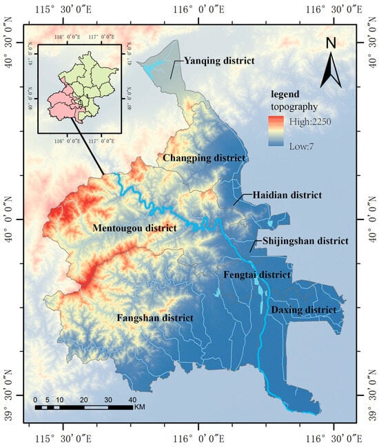
Figure 1.
Scope of the study map. Map was generated using ArcGIS 10.8 (www.esri.com/software/arcgis, accessed on 9 November 2025), drawn by the authors.
As Beijing’s “Mother River”, the Yongding River rushes from northwest to southeast, nourishing the land of the capital region and fostering the prosperity of this ancient capital. However, historical records show that from the Yuan Dynasty to the Qing Dynasty, the Yongding River breached its banks 124 times, shifted its course 10 times, and caused 7 floods that inundated the capital city—bringing untold disasters to the region. More critically, the river carried an astonishing amount of sediment, which posed not only a major challenge to agricultural civilizations but also a profound test of human wisdom and resilience.
In the face of such hardships, ancient inhabitants built water heritage sites to manage and utilize water resources. This led to the formation of a dense concentration of water heritages within the study area. A total of 260 water heritages has been recorded within the study area, encompassing dams, irrigation systems, canals and associated structures. The construction periods of the hydraulic engineering works (or “hydraulic structures”) constituting this water heritage span from the Three Kingdoms period through to the modern era.
2.2. Research Subjects and Data Sources
This study uses data from the “ The Xishan–Yongding River Cultural Belt Water Heritage Database”, compiled by the Beijing Water Culture Research Group through field surveys in 2024. Data collection was conducted through extensive field surveys, supplemented by historical records, archival maps, and water engineering documentation. To ensure the accuracy of geographic data, the coordinates of each site were precisely validated using the handheld GPS device (etrex20, Garmin, Taiwan, China), with a positional error margin of ±3 m. This methodology ensures a high degree of spatial precision and reliability for subsequent analysis.
The base geographic data, which includes a 30 m resolution Digital Elevation Model (DEM) and administrative boundaries, were sourced from the Alibaba Cloud Visualization Platform (https://datav.aliyun.com/portal, accessed on 9 November 2025). Hydrological data were integrated after spatial registration with the basic geographic information database (1:1,000,000 scale) provided by the National Geographic Information Resource Directory Service System (https://www.webmap.cn, accessed on 9 November 2025).
This comprehensive database serves as the primary data source for the study, providing high accuracy and integration of spatial and hydrological data. Its detailed coverage makes it well-suited for analyzing the distribution and significance of water heritage sites in the region.
2.3. Technical Methodology
In this study, the water heritages within the Xishan–Yongding River cultural belt serve as the primary research subject. First, using charting techniques, the study visually analyzes the distribution characteristics of water heritages across administrative regions and various types. The study employs ArcGIS 10.8.1 to create a spatial distribution map of water heritage within the Xishan–Yongding River cultural belt and utilizes spatial analysis methods to examine the temporal and spatial evolution patterns and influencing factors of water heritage. Among these methods, the kernel density tool is used to identify the clustering degree of high and low values of water heritage at different periods within the cultural belt. The standard ellipse tool is applied to analyze the spatial aggregation of water heritage over time, revealing trends in the shifting focus of construction. The study also utilizes the average nearest-neighbor index to calculate the spatial clustering and dispersion of various types of water heritage. Finally, buffer zone analysis is applied to further investigate the spatial relationships and impact areas.
2.3.1. Kernel Density Estimation
Taking known water heritages data points as cores, this method calculates the density contribution of each grid cell within a specific range (a circle with a given radius) via the kernel density function. The density contribution varies with distance from the core point: the closer the distance, the larger the contribution, with a default value of 0 at edge points.
Higher kernel density values indicate greater spatial density of water heritage. This method can calculate water heritage density in specific areas, thus directly reflecting the spatial distribution of scattered water heritage sites in continuous regions [31]. The kernel density calculation formula for water heritages are as Equations (1) and (2).
where is the kernel density estimate at location ; a denotes the number of water heritages; is the kernel function; D is the ratio of the distance from the center point of the grid cell to the water heritages point to the search radius R.
2.3.2. Standard Deviational Ellipse
The standard deviational ellipse is a tool in GIS for quantifying the spatial distribution of water heritages. Taking the spatial centroid as the starting point, it obtains the semi-major axis, semi-minor axis and rotation angle of the ellipse by calculating variance, covariance, etc., to depict the distribution characteristics of heritage. It can measure the agglomeration, dispersion trends and dominant directions of water heritage, while visualizing spatial patterns across periods and reflecting heritage changes influenced by relevant factors [32]. The calculation formulas are as Equations (3) and (4).
In the formulas: XSDE YSDE are the coordinates of the center of the ellipse; (xi, yi) are the coordinates of the i-th element; (, ) is the area—weighted average center (centroid) of the elements; n is the total number of elements.
2.3.3. Mean Nearest Neighbor Index
The spatial distribution of point-like water heritage is primarily characterized by three types: uniform, random, and clustered. To clarify its spatial distribution characteristics, the average nearest neighbor index (R) can be adopted for quantitative analysis. This index can effectively characterize the mutual proximity relationships of point-like water heritage in geographical space, and thus accurately identify its spatial distribution types [33]. The calculation formulas is described as Equation (5).
In the formula, is the actual average nearest neighbor distance, that is, the average value of the distances between each water heritage site and its actual nearest neighbor site; is the theoretical average nearest neighbor distance, which is the average nearest neighbor distance when the point—shaped elements are completely randomly distributed in the study area; is the number of water heritage sites in the study area; di is the distance between water heritage sites; is the area of the study area. When > 1, the distribution of water heritage is uniform; when = 1, the distribution is random; when < 1, the distribution is agglomerated.
3. Results
3.1. Quantitative and Typological Profile
The Xishan–Yongding River cultural belt encompasses a diverse and rich array of water heritage sites. For ease of analysis, the sites have been divided into four functional categories according to the purpose of the works: (1) hydraulic engineering heritages, (2) non-hydraulic engineering heritages, (3) historical water systems, and (4) post-1949 representative hydraulic engineering heritage [24]. Furthermore, these categories are further subdivided into 17 subcategories based on architectural typology (Figure 2).
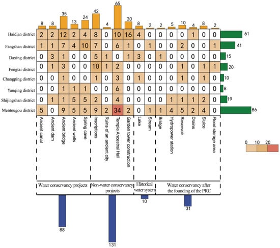
Figure 2.
Distribution of Different Types of Water Heritage, drawn by the authors.
It was observed that non-hydraulic engineering heritages constitute the largest proportion, with 131 sites (50.38%), while historical water systems represent the smallest proportion, with only 10 sites (3.8%). At the subcategory level, temples constitute 25% of the total (65 sites), followed by inscriptions (42 sites) and ancient bridges (35 sites), each exceeding 10%. Heritage types such as ancient urban ruins, rivers, and hydropower stations are underrepresented.
From the perspective of administrative regions, in the major categories, both hydraulic engineering heritage and non-hydraulic engineering heritage are most prevalent in Mentougou District, with 22, 47, and 16 items, respectively, accounting for 25.0%, 35.9%, and 47.1%. The highest number of historical water systems is found in Haidian District, with 4 items, accounting for 40.0%.
In the minor categories, the ancient bridge category (12 items) and the garden pagodas category (16 items) exhibit the largest numbers in Haidian District, accounting for 34.3% and 80.0%, respectively. For the spring-cave heritage category (6 items), the highest concentration is found in Fangshan District, accounting for 50.0%. The temples category (34 items) is most prevalent in Mentougou District, accounting for 62.5%.
Spatial density analysis reveals significant disparities. Haidian District exhibits the highest heritage density (0.247 sites/km2), followed by Shijingshan District (0.132 sites/km2), while Fangshan District demonstrates the lowest density (0.012 sites/km2) (Table 1). The markedly elevated densities in Haidian and Shijingshan underscore the concentrated distribution pattern of water heritage within the Xishan–Yongding River cultural belt. This pattern can be attributed to Haidian and Shijingshan being focal points for hydraulic infrastructure since the Jin-Yuan dynasties, particularly non-engineering landmarks like the Three Hills and Five Gardens complex [34]. Fangshan District, on the other hand, covers the largest area, with a complex terrain that presents significant challenges for both construction projects and the preservation of cultural heritage [35].

Table 1.
Overview of Water Heritage Quantity and Density.
3.2. Temporal Distribution Patterns
Based on the timeline of hydraulic development in the Xishan–Yongding River region [36,37], the water heritages of the Xishan–Yongding River cultural belt is divided into six historical periods. The division is based on the construction dates of the hydraulic works (or “hydraulic structures”) that constitute this water heritage, covering the Wei-Jin and earlier period, the Sui-Tang-Five Dynasties period, the Song-Liao-Jin-Yuan dynasty, the Ming dynasty; the Qing dynasty; and the modern era.
3.2.1. Temporal Changes in Water Heritage
The temporal distribution of the water heritage is characterized by a long-time span, strong historical continuity, and distinct phases. There are notable differences in the quantity of hydraulic works (or “hydraulic structures”) that form this water heritages across the various historical periods. With the exception of modern hydraulic projects, the distribution of various types of water heritage generally follows a “∧” shape (Figure 3). The Ming and Qing periods saw the highest number of water heritage sites, accounting for approximately 58.08% of the total. In contrast, fewer water heritage sites remain from the Pre-Wei-Jin period and the Sui-Tang Five Dynasties period, while the number of water heritage sites increased during the Song-Liao-Jin-Yuan period. The Ming and Qing periods saw the highest number of water heritage sites, accounting for approximately 58.08% of the total. In contrast, fewer water heritage sites remain from earlier periods such as Pre-Wei-Jin and the Sui-Tang Five Dynasties. The main reasons for this are as follows: The Xishan–Yongding River cultural belt is one of the earliest cradles of human civilization, containing significant sites such as the Peking Man Site at Zhoukoudian, the Donghulin site, and the Liulihe Site, which represent early development of hydraulic technologies [38,39]. However, due to the vulnerability of water heritage to flooding, the longer the time that has passed, the fewer surviving sites there are. The Song-Liao-Jin-Yuan period marked the beginning of Beijing as the capital, and during this time, the state vigorously developed the Xishan–Yongding River area, constructing numerous temples, gardens, and imperial tombs, increasing the demand for hydraulic engineering [40]. The Ming and Qing dynasties, as the peak of Beijing’s political and cultural significance, witnessed profound economic, technological, and social development. The Xishan region, in particular, became an important royal cultural and summer retreat destination, with emperors commissioning the construction of large-scale imperial gardens [41]. At the same time, urban expansion and the growing demand for water resources led to the development of numerous water diversion projects. In contrast, the modern era is characterized by a shorter time frame, which has resulted in many modern hydraulic works not yet being recognized as water heritage, leading to fewer such water heritage sites being officially documented.
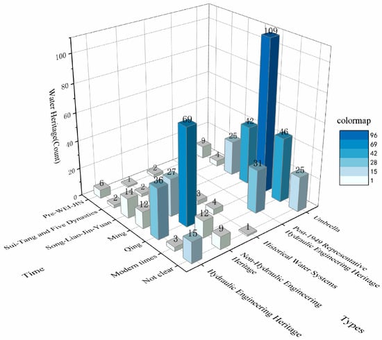
Figure 3.
Distribution of Water Heritages Types by Number Across Historical Periods, drawn by the authors.
3.2.2. Distribution of Water Heritage Across Different Periods
The water heritage within the study area demonstrates distinct patterns in both typology and spatial distribution across different historical periods. As shown in Figure 4a, the Pre-WEI-JIN period signifies the origin of regional culture, represented by approximately nine water heritage sites, primarily composed of non-hydraulic engineering elements such as spring-cave heritage and lakes. These sites are predominantly concentrated in the Liuli River area of Fangshan District. During the Sui-Tang and Five Dynasties periods, the number of water heritage sites remained relatively low, with around four sites. The distribution follows a multi-core pattern, scattered across the key regions of the Xishan–Yongding River cultural belt, including Fangshan, Mentougou, and Haidian Districts (Figure 4b).
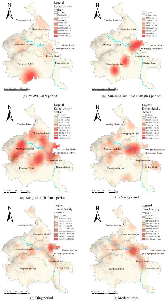
Figure 4.
Kernel Density Map of Water Heritages for Different Periods. Map was generated using ArcGIS10.8 (www.esri.com/software/arcgis), drawn by the authors.
The Song-Liao-Jin-Yuan periods saw an increase in the number of regional water heritage sites to around 25, with prominent types including ancient wells, temples, shrines, and ancient bridges. The spatial distribution during this period continued to exhibit a pattern of small clusters interspersed with larger dispersions, with notable concentrations around Guji Mountain, Qingshui Town, and the small Western Hills, spreading outward into the plains. This reflects a trend of shifting from the mountainous areas toward the plains (Figure 4c).
During the Ming period, the number of water heritage sites increased to approximately 42, primarily consisting of temples. These sites are primarily concentrated in the western foothills and the small Western Hills, exhibiting a clear, collective spatial distribution (Figure 4d). During the Qing period, as the pinnacle of the feudal dynasty, the number of water heritage sites surged to around 109, including ancient bridges, inscriptions, temples, and garden pagodas. Water heritage during this time was highly concentrated in the small Western Hills, where the density was significantly higher than in surrounding areas, and along the Yongding River, which also exhibited a notably high concentration (Figure 4e). This was mainly due to the fact that the Yongding River experienced a number of floods during the Ming Dynasty and Qing Dynasty and in order to manage the water resources of the Yongding River, a large number of flood control and water projects were constructed along its banks [42].
In the modern period, approximately 46 water heritage sites remain, largely composed of modern hydraulic infrastructure, including reservoirs, sluice gates, and hydropower stations. These sites are primarily concentrated along the Yongding River, with a notable trend of expansion into surrounding areas (Figure 4f). Chronologically, the dominant heritage types within the cultural belt transitioned from hydraulic infrastructure to non-hydraulic structures.
In order to systematically analyze the spatial distribution and directional trends of water heritage sites in different periods, we use standard deviation ellipse (SDE) with center of gravity migration plotting to generate the main distribution ellipse for each historical period [43]. By observing the center of gravity migration paths, we can analyze the changes in the main flow directions and concentration areas of water heritage in different periods, which provides an important reference basis for urban planning and resource allocation.
The results indicate that the center of distribution of water heritage along the Xishan–Yongding River cultural belt shows a trend of shifting from south to north and from mountainous areas to plains. Additionally, the ratio of the long axis to the short axis of the standard deviation ellipse gradually decreases, suggesting that the distribution of regional water heritage is becoming more concentrated (Figure 5). Prior to the Song-Liao-Jin-Yuan dynasties, water heritage sites were generally distributed in a southwest-northeast direction, with the distribution center situated in Fangshan District. Following this period, the distribution shifted to a northwest-southeast orientation, with the distribution center gradually migrating toward the junction of Shijingshan and Mentougou District, near the point where the Yongding River exits the mountains. This migration and pattern of change are closely associated with the evolution of regional human civilization, urban development processes, and the direction of urban construction [44]. This also emphasizes the necessity of establishing a “zoning and grading” protection framework for water heritage within the cultural belt, while proposing specific conservation strategies tailored to the characteristics of water heritage in various regions.
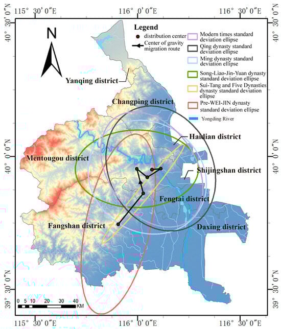
Figure 5.
Elliptical difference and center of gravity distribution of water heritages. Map was generated using ArcGIS 10.8 (www.esri.com/software/arcgis), drawn by the authors.
3.3. Spatial Distribution
3.3.1. Characteristics of the Spatial Distribution of Water Heritage Sites
Using ArcGIS 10.8.1, the nearest-neighbor index for water heritage sites within the Xishan–Yongding River cultural belt was calculated, yielding an r-value of 0.303554 (<1), a z-score of −21.442143 (<−2.58), and p of 0. These results indicate a significant spatial clustering of water heritage sites in the region. The overall density of water heritage sites within the Xishan–Yongding River cultural belt was analyzed using the kernel density tool (Figure 6). Water heritage sites within the cultural belt predominantly exhibit a “multi-core, contiguous distribution” pattern. Specifically, three high-density areas have been identified in Longquan Town (Mentougou District), Xiangshan Park (Haidian District), and the Summer Palace (Haidian District). Two secondary-density areas are located in Lugou Bridge (Fengtai District) and Changgou Town (Fangshan District). Six low-density areas are located in the core regions of Nanhaizi Park (Daxing District), Zhaitang Town (Mentougou District), Shijiaying Township (Fangshan District), Yufa Town (Daxing District), Zhangshanying Town (Yanqing District), and Liucun Town (Changping District).
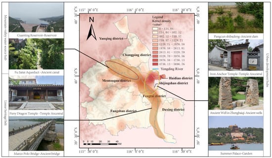
Figure 6.
Density Map of Water Heritages along the Xishan–Yongding River Cultural Belt. Map was generated using ArcGIS 10.8 (www.esri.com/software/arcgis), drawn by the authors.
Spatially, the distribution of water heritage follows a “two-core, one-belt” pattern (Figure 6). The valley water hub centered on the Guanting Reservoir is a core area of water heritage concentration, consisting mainly of canals and reservoirs (e.g., FuJiatai Aqueduct), which is an important source of water for both urban and rural areas. Another aggregated core is located in the plains where the Yongding River meets urban development (e.g., Sanjiadian, Three Hills and Five Gardens), and contains embankments (e.g., Pangcun shibadeng), which are mainly used for flood control and transport. A large number of historical relics related to the management, use and culture of water are also gathered here (e.g., Iron Anchor Temple, Zhengbaiqi Ancient well and Summer Palace). The linear heritage belt, extending along the main channel and tributaries of the Yongding River (e.g., the Qingshui River), forms a network of water facilities that connect villages, temples, and ancient roads, thereby creating an ecological-cultural corridor within the broader cultural belt (e.g., Fiery Dragon Temple and Marco Polo Bridge). This distribution pattern not only underscores the supportive role of water engineering in urban development but also reflects the civilizational transition from “survival-oriented water management” to “ecological water management” [45]. It provides both a temporal and spatial framework for the comprehensive preservation of regional water heritage.
The spatial arrangement of water heritage sites within the Xishan–Yongding River cultural belt is intricately linked to regional hydrological conditions and the historical trajectory of human activity. From a distribution perspective, major rivers such as the Yongding River and Juma River provided essential water sources for ancient human settlements and agricultural production. As hydraulic infrastructure was developed along these rivers, a linear distribution of water heritage sites emerged along the main waterways. Furthermore, the geography of the upstream river areas offered natural conditions for water storage and diversion. The undulating terrain facilitated the control and direction of water flow, resulting in an interconnected network of water supply systems. The high concentration of water heritage indicates that its preservation must strike a balance between historical layers and spatial connections. This spatial distribution also supports the planning of future linear heritage corridors and the development of tourism routes that leverage water heritage resources [46].
The average nearest neighbor analysis was performed on different types of water heritage within the cultural belt (Table 2). The results indicate that four categories, including inscriptions and ancient bridges, show clustered distributions, with the highest concentration observed in the temples category. Four other categories, such as garden pagodas and ancient sluices, exhibit random distributions. The remaining eight categories demonstrate varying degrees of dispersion, with bridges showing the highest level of dispersion and ancient wells showing the lowest. Furthermore, a kernel density analysis was performed for the four major categories and four subcategories with significant clustering features, including inscriptions, ancient bridges, temples, and lakes, as illustrated in Figure 7.
Table 2.
Average Nearest Neighbor for Different Types of Water Heritages.
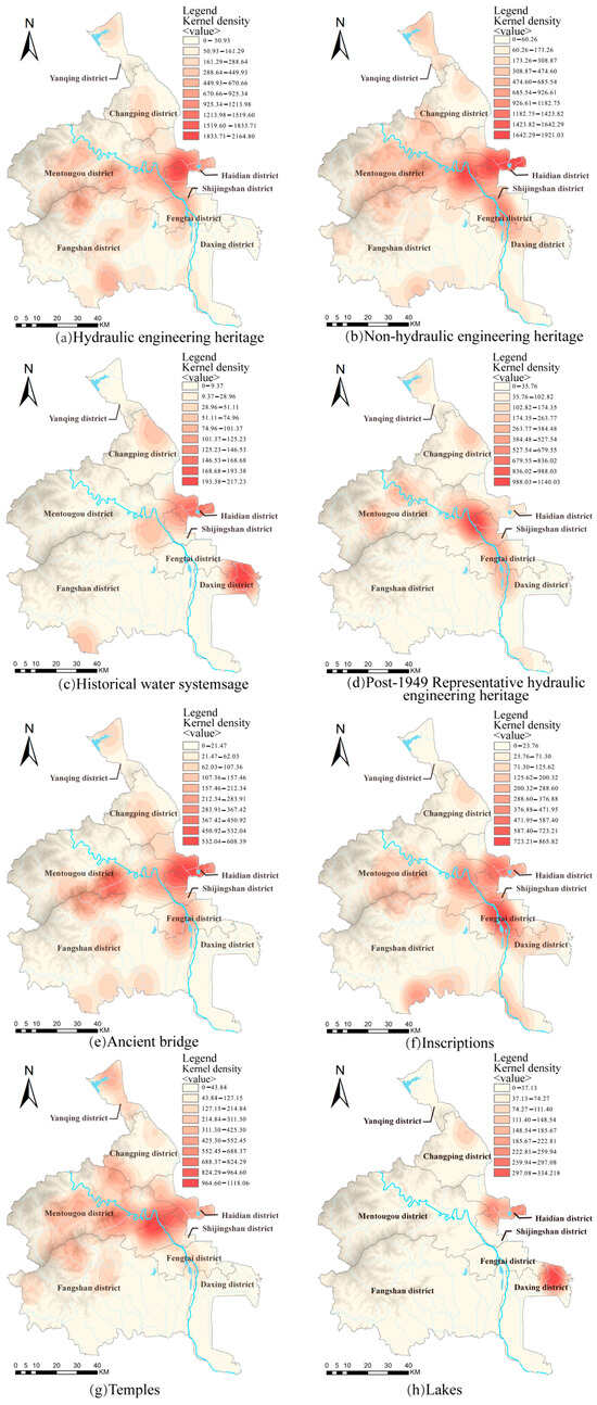
Figure 7.
Kernel Density Analysis of Major Types of Water Heritages. Map was generated using ArcGIS 10.8 (www.esri.com/software/arcgis), drawn by the authors.
- Distribution of Hydraulic Engineering Heritage: This type of heritage follows a spatial pattern aligned with river systems, with concentrations along the upper, middle, and lower reaches of the Yongding River basin. The distribution exhibits a stepped segmentation, following the natural course of the river and key geographic nodes. In the upper reaches, the focus is on hydraulic source exploitation, as well as dam and canal construction reflecting the early use of irrigation systems and the ancient management of water resources. The middle reaches are characterized by typical irrigation systems and flood control structures, forming a more complete group of water engineering heritage that illustrates the control of water flow and its close relationship with agricultural society. The lower reaches focus on flood control and dam-gate systems.
- Distribution of Non-Hydraulic Engineering Heritage: This type of heritage is widely distributed across the cultural belt, with concentrated areas in specific locations, such as Longquan Town in Mentougou and the Three Hills and Five Gardens in Haidian District. Non-water engineering heritage refers to cultural relics related to water management and activities, aimed at maintaining water benefits, facilitating management, or meeting social needs, from historical periods. These types of heritage are closely linked to human activity. Longquan Town in Mentougou, located at the alluvial fan of the Yongding River, has historically served as a key flood control node, with a dense concentration of heritage sites, such as the Dragon King Temple and inscriptions, reflecting human intervention in the river’s hydrological characteristics. The Three Hills and Five Gardens area in Haidian District, leveraging the spring water resources of the Western Hills and its wetland ecosystems, emerged as a focal zone for Qing imperial hydraulic projects, exhibiting a high concentration of heritage sites [47].
- Distribution of Historical Water Systems: This type of heritage displays a distinct clustered pattern along river systems, with notable high-density areas in the middle and lower reaches of major rivers, such as the Yongding River and Juma River. Its formation is closely linked to the natural hydrological conditions of the rivers and the needs of human production and life. The flat terrain and abundant water supply in the middle and lower reaches were central to ancient agricultural irrigation, as well as the development of water transportation and settlements. The spatial concentration of this heritage not only highlights the guiding role of river corridors in water infrastructure but also validates Beijing’s evolutionary trajectory as a hydraulic-driven civilization.
- Distribution of Post-1949 Representative Hydraulic Engineering Heritage: These water engineering projects follow a spatial pattern focused on key river systems and critical nodes, characterized by large scale and multifunctionality. Their distribution logic is deeply tied to the water management policies of the new China and the development needs of the capital. The Yongding River basin, as a key flood control area, saw the construction of major control works such as the Guanting Reservoir and Sanjiadian Barrage starting in the 1950s [48], forming a series of interconnected water engineering hubs that embody the “comprehensive control of the Yongding River” strategy [49].
- Distribution of Inscriptions: These inscriptions typically exhibit a clustered distribution around core water activity areas, with concentrations in river engineering zones, water administration nodes, and water deity worship sites. The distribution of inscription-based water heritage is closely related to the intensity of local water management, administrative structures, and cultural transmission needs [8]. In areas frequently affected by floods along the Yongding River, inscriptions related to water control are densely distributed in flood embankment restoration zones or around dam hubs, following the tradition of “commemorating achievements with inscriptions”. In contrast, inscriptions found in water deity temples such as Dragon King’s Temple, adhere to the folk belief logic of “communicating with the gods through inscriptions,” recording rain prayer rituals, temple donations, and similar activities, thus creating a dual space for water management and spiritual education [50].
- Distribution of Temples Heritage: The distribution of temples heritage along the Xishan–Yongding River cultural belt follows a “small clusters, large dispersion” pattern. It is primarily concentrated in the central and eastern parts of the cultural belt, particularly in the Yongding River valley area, and scattered across most of the region. The temples mainly consist of physical structures, such as temples and ancestral halls, built to worship river gods, water deities, and well spirits, originating from the reverence for nature and the desire for blessings and good fortune. The Yongding River is the only river in the Beijing area to have been deified, and water worship in the cultural belt is primarily centered on the veneration of the Yongding River God. As a result, most of this water-related heritage is concentrated along the banks of the Yongding River.
- Distribution of Ancient Bridge Heritage: These bridges demonstrate linear distribution patterns along major waterways, with notable clustering in population-dense zones (Haidian, Shijingshan Districts) and historical transport nodes (Lugou Bridge, Sanjiadian). Their spatial configuration reflects both essential river-crossing needs and the interaction between hydrological conditions and human adaptation. At river confluences and water diversion hubs, bridges frequently integrate with sluice gates and embankments to form comprehensive hydraulic networks.
- Distribution of Lakes: This type of water heritage is primarily located near the former course of the Yongding River, characterized by a spatial pattern of “suburban linkage and clustered lakes.” The core area consists of the Yongding River’s alluvial fan and the groundwater discharge zone at the foot of the mountains, forming a dual cluster of lakes: one group near the royal gardens on the outskirts of the capital, and another in the wetland lakes of the Beijing suburbs. This spatial distribution pattern necessitates a focus on the comprehensive protection of the historical context of the lake systems in the future, to prevent fragmented development from compromising the authenticity of the heritage.
The distribution of causes is primarily influenced by the geographic characteristics of the river basin. Alluvial plains and foothill transition zones, formed by major rivers such as the Yongding and Juma Rivers, along with their tributaries, provided natural terrain and water sources for the construction of waterworks. Secondly, the frequent historical need for flood control has driven the development of water infrastructure. From the Jin dynasty’s Liling Dam and the Yuan dynasty’s Jinkou Rivers water diversion project, to the Ming and Qing dynasties’ dike systems, successive water management practices have resulted in a cumulative engineering effect in the middle and lower reaches of the rivers. Furthermore, agricultural development and settlement expansion in the basin have created demand for water infrastructure. The prosperity of rice cultivation in the western Beijing area, as well as the irrigation systems in the suburban regions of Wanping during the Ming and Qing dynasties stimulated the creation of dense irrigation systems and supporting waterworks [51].
3.3.2. Factors Influencing the Spatial Distribution of Water Heritage
The spatial distribution of water heritage reflects the combined evolution of natural geographical constraints, socio-economic activities, and historical-cultural processes. This study identifies five core factors like rivers, settlements, elevation gradient, topographic slope, and political systems through which the location patterns of water heritage in the Xishan–Yongding River cultural belt are systematically analyzed. Among these, natural geographical factors (river distribution, elevation, and slope) form the foundational framework for the distribution of heritage, while settlement locations reflect the socio-economic logic of “human–water” interaction. Political systems illustrate the role of state power in shaping water heritage.
- 1.
- Rivers
Using ArcGIS, buffer zones with radii of 250 m, 500 m, and 750 m were created for rivers with an average annual flow exceeding 5000 m3/s within the Xishan–Yongding River cultural belt (Figure 8). A total of 168 water heritage sites are located within the 750 m buffer zone, accounting for 64.89% of the total. Specifically, 84 sites are located within the (0, 250 m] buffer zone (32.31% of the total), 46 sites within the (250 m, 500 m] buffer zone (17.69%), and 38 sites within the (500 m, 750 m] buffer zone (14.62%). The spatial distribution analysis reveals a marked hydrological determinism in water heritage locations, exhibiting a characteristic distance-decay pattern where site density declines exponentially with increasing distance from the river course. This phenomenon is linked to the fundamental dependence on water in ancient times, where these administrators strategically placed infrastructure near water sources to optimize resource use and operational efficiency. This was coupled with the need for extensive flood mitigation works such as dykes, diversion canals and sluices to cope with the constant threat of flooding [52]. For example, the Zhuwo Reservoir, Pangcun Shibadeng, and the Qiuxian Dam are all situated within the 0–250 m buffer zone, reflecting the well-planned layout of ancient water management systems that supported efficient use of water resources and effective flood control.
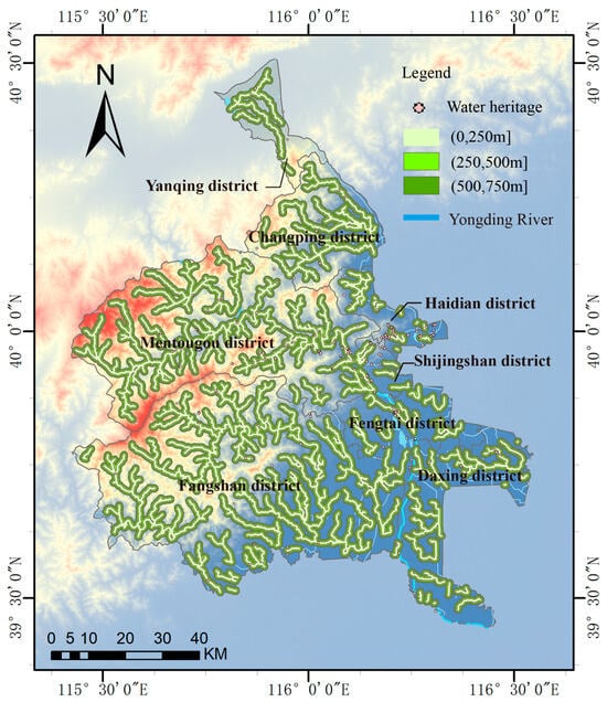
Figure 8.
Distribution Map of Rivers and Water Heritages. Map was generated using ArcGIS 10.8 (www.esri.com/software/arcgis), drawn by the authors.
This distribution pattern provides constructive inspiration for the management of our water heritages. It created a concentrated belt of water heritages within the immediate riparian zone that now warrants a stratified conservation approach with rigorous protection measures enforced within the 750 m core buffer area and progressively diminishing intervention intensities applied across expanding concentric zones to reflect the spatial gradient of heritage significance and vulnerability.
- 2.
- Villages
As of 2024, there are 16 traditional Chinese villages in the Xishan–Yongding River cultural belt, in which eight ones are recognized at the municipal level in Beijing. Spatial analysis methods on the ArcGIS platform were used to create concentric circular buffer zones around the geometric centers of the villages, with radii of 1000 m, 1500 m, and 2000 m (Figure 9). Statistical analysis shows that 35 water heritage sites are distributed within the 1000 m buffer zone (13.46%), while only 10 are found within the (1000 m, 1500 m] zone (3.85%), and 5 sites remain in the (1500 m, 2000 m] zone (1.92%). The data show a clear gradient decay pattern, where the density of water heritage sites decreases exponentially as the buffer radius increases. The main factors contributing to this pattern are as follows: First, traditional settlements followed the principle of “settling by water”, with villages located near rivers, springs, and other water sources to meet irrigation, domestic water, and defense needs [53]. Second, the landscape within the cultural belt is primarily mountainous and hilly [54], and the elevation differences in the terrain increase the cost of constructing long-distance water transport systems, which naturally promotes the spatial integration of water heritage and villages. Furthermore, water-related cultural heritage sites, such as Dragon King Temples and Water God Temples, emerged from local “water deity worship” customs and are often located in the core areas of villages due to the daily religious activities that require proximity [55]. In addition, water facilities located in outer buffer zones (>2000 m), removed from densely populated areas, are more vulnerable to natural erosion or abandonment over time. In contrast, facilities near the core have survived due to ongoing maintenance. Human settlements are typically located near rivers for easy access to water, and water infrastructure is often built around these settlements, further reinforcing the spatial connection to rivers. The distribution of water heritage in the Sanjiadian Village at the exit of the Yongding River is an excellent example of this phenomenon. The village is a typical water-based settlement, located just about 500 m from the Yongding River. It is home to several historical water facilities and cultural heritage sites, including the Dragon King’s Temple, the Iron Anchor Temple, the Sanjiadian Reservoir, and the railway bridge. This also validates the historical rationale behind the “water-village symbiosis” ecological pattern.
Figure 9.
Distribution Map of Villages and Water Heritages. Map was generated using ArcGIS 10.8 (www.esri.com/software/arcgis), drawn by the authors.
- 3.
- Elevation
According to ArcGIS statistics, most water heritage sites in the Xishan–Yongding River cultural belt are located within the elevation range of (0, 500] m, with 222 heritage sites in this range, accounting for 85.38% of the total. These water heritage sites are mainly distributed in the areas shown in Figure 10. Fertile soils in the low-elevation river valley areas are conducive to human settlement and activities [56]. To meet large-scale irrigation needs, water management facilities were developed, leading to the creation of additional water heritage sites [7]. Additionally, the meandering nature of the Yongding River necessitated the construction of extensive flood control and irrigation works in its lower reaches, while the alluvial fan plains formed numerous water-related relics like lakes. Taking the Haidian area of the Yongding River as an example, its unique alluvial fan plain has supported the formation of lakes and wetlands, making it an important region for rice cultivation. Gaoshui Lake is one typical remnant, showing the close connection between river sedimentation and human water management activities.
Figure 10.
Distribution Map of Elevation and Water Heritages. Map was generated using ArcGIS 10.8 (www.esri.com/software/arcgis), drawn by the authors.
- 4.
- Slope
The slope distribution of water heritage sites in the Xishan–Yongding River cultural belt is characterized by “concentrated gentle slopes and sparse steep slopes”. Of these, 218 water heritage sites are located within the (0, 15°] slope range, accounting for 83.85% of the total (Figure 11). This distribution results from the interaction between natural geographical conditions (such as the gentle slopes of the alluvial fan and the meandering river course), human survival needs (agricultural irrigation, flood protection), and historical engineering limitations. This pattern, together with the elevation analysis showing that 85.38% of the sites are in the (0–500] m range, confirms the spatial feature of “dense water heritage in lowland areas” [57]. Both the Dragon King’s Temple and the ancient bridge in Jiuyuan Village are located in the low-lying areas of the settlement. At the same time, the water flow is stable in the areas with gentler slopes, making it easier to build and maintain water facilities over the long term. Given this spatial distribution, flood control and disaster management should be prioritized. Lowland areas are vulnerable to flooding threats, making it essential to improve drainage and irrigation systems, strengthen the flood control capacity of embankments, preserve natural flood discharge areas, and enhance monitoring and protection of key heritage sites.
Figure 11.
Distribution Map of Slope and Water Heritages. Map was generated using ArcGIS 10.8 (www.esri.com/software/arcgis), drawn by the authors.
- 5.
- Political System
The spatial and temporal distribution of water heritages along the Xishan–Yongding River cultural belt are also influenced by the political systems of various dynasties. The Jin, Yuan, Ming, and Qing dynasties relied on water management as a strategic means to ensure the stability of their capitals, establishing a tradition of “government-led water management” [58]. This governance strategy of “ritual replacing governance” created a political metaphor for the “divine right of kings” through physical space, resulting in a unique institutional landscape of water heritage.
The spatial distribution of water heritage along the Xishan–Yongding River cultural belt is influenced by a combination of natural geographical conditions, socio-economic demands, technological limitations, and cultural beliefs, rather than by a single factor. This spatial distribution pattern not only reflects the high dependency of ancient society on water resources, but also reveals the complex interplay between human activity and the natural environment. In the sustainable preservation and utilization of water heritage, local customs and cultural practices should be thoroughly considered and integrated, while modern technologies should also be incorporated in education, planning, and application [59,60].
4. Discussion
This study takes the water heritages of the Xishan–Yongding River cultural belt as its object of study from the spatial and temporal dimensions. The study adopts graphical analysis and geographic information system (GIS) software to systematically explore the distribution characteristics and patterns of the water heritages in the cultural belt, taking into account the construction dates, types and spatial distributions of the water projects (or “water structures”) that make up the heritage. The results of the analyses show that the water heritage exhibits an obvious concentration and regular distribution in type, time and space: (1) There are various types of water heritage in the cultural belt, including canal locks and dams, irrigation channels, flood control dykes, ancient bridges and ancient ferries. The number of non-engineered water heritage is the largest, with temple heritage occupying a larger proportion. Regionally, Mentougou has the greatest variety and quantity of water heritages, while Haidian has the greatest density of water heritages. (2) Chronologically, water heritage spans a vast temporal range, exhibiting strong historical continuity alongside distinct phased characteristics. The total volume of heritage follows a ‘∧’-shaped distribution, with the Qing dynasty period accounting for the most substantial quantity. The distribution center shows a trend of shifting northwards from the south and moving from mountainous regions towards plains. Over time, the predominant type of water heritage has transitioned from engineering structures to non-engineering forms. (3) Overall, the water heritages in the study area shows a spatial distribution pattern of “multi-core and continuous distribution”, with obvious concentration characteristics. Three high-density zones, two medium-density zones and six low-density zones were thus formed. Among the smaller types, stone monuments and ancient bridges show obvious aggregation. This spatial distribution is very conducive to the protection of heritage sites and the development of unified conservation planning. (4) Natural factors such as river systems, villages, altitude and slope, and cultural factors such as political environment play a key role in the spatial clustering of water heritage.
As one of the important origins of Beijing city, the spatial and temporal distribution of water heritage in the Xishan–Yongding River cultural belt is a reflection of the superposition effect of historical development. Initially, people chose to live near the water out of the demand for water resources, and built a large number of water diversion facilities. In order to avoid frequent floods, flood defenses were built in the plains of the study area. Later on, to meet the needs of the rulers, a large number of intensive garden projects were also constructed in the Haidian area where water resources were better, which is the main reason for the richness of the region’s hydraulic heritage in the non-hydraulic engineering category. Also the study area, like the Indian pair, has been worshiping and respecting rivers since ancient times [61], and hence there would have been a large number of altar and temple architectural heritage used for rituals in the vicinity of rivers and important water sources.
However, these studies are still preliminary, and efforts are still needed for the future conservation and development of water heritage in the Xishan–Yongding River cultural belt. Furthermore, detailed analyses on a regional scale of the water projects (Mentougou Irrigation Canal) of the historical period in the study area, exploring their construction backgrounds using materials, construction techniques and other technologies, can provide references for contemporary Yongding River basin management (flood control, water conservation, water resource allocation). However, these studies are still in the preliminary stages, and more efforts are needed in the future for the protection and development of the water heritage in the Xishan–Yongding River cultural belt. A more detailed analysis of historical water projects in the study area (such as the Mentougou Irrigation Canal and the Pangcun Shibadeng) on a smaller scale, exploring their construction background through materials, building techniques, and other methods, can provide more specific references for contemporary management of the Yongding River Basin (such as flood control, water conservancy, and water resource allocation). At the same time, the path of adaptive use of water heritage should also be actively explored and incorporated into the development of cultural tourism industry and ecological construction planning. Similar actions were attempted in INCULTUM, Portugal [62].
Although this study uses GIS tools to comprehensively explore the distribution characteristics of water heritage in the Xishan–Yongding River cultural belt from the spatial and temporal dimensions, and its influencing factors are also explored, there are some limitations and shortcomings: (1) The heritage database used in this study mainly relies on the field survey data. Although this method ensures the accuracy and authenticity of the data, it is affected by the large scope of the study area and other factors The database may not be able to comprehensively include all the water heritage sites in the region. In addition, some heritage information may lack accurate records due to historical changes, thus affecting the completeness of the data. (2) The spatial and temporal distribution of water heritage sites in the Xishan–Yongding River cultural belt is a complex response to multiple factors such as natural geography, political system, and socio-economics, and the mutual influence of the influencing factors is still worthy of further study.
5. Conclusions
This study conducts a comprehensive analysis of the spatiotemporal distribution of water heritage in the Xishan–Yongding River cultural belt, and reveals the dynamic relationships between the natural environment, historical context, and human settlements. By integrating Geographic Information System (GIS), field surveys, and spatial analysis tools, it aims to present a detailed overview of the water heritage landscape and highlight their geographical distribution and temporal evolution. This research contributes to an in-depth understanding of these water heritages and provides valuable guidance for their systematic and scientific protection.
The results of these studies have important implications. On the one hand, they provide a scientific basis for the future conservation of the Xishan–Yongding River cultural belt water heritage, including the identification of key conservation areas, the selection of pilot census areas, and the provision of rational pathways for the development of the water heritage, all of which demonstrate a wide range of applied value and guidance. On the other hand, these results break away from the traditional concept of analyzing heritage at a specific level. This study shows the world the spatial distribution of water heritage in Beijing from a broader perspective, revealing the formation and development process of regional water heritage.
Looking forward, the findings of this study can provide a basis for the development of conservation strategies that need to take into account the historical significance of water heritage in the region as well as the challenges it will face in the future. In addition, the methodology used in this study provides an important reference for others integrating heritage conservation in urban and semi-arid environments.
Finally, we hope that this study will draw global attention to the water heritage of the Xishan–Yongding River cultural belt. Water heritage is a great witness to the long history of Chinese civilization, and the Xishan–Yongding River Cultural Belt is the foundation for Beijing to build a world cultural city. We should carefully protect this “golden card” of water heritage and highlight the overall value of Beijing’s historical and cultural heritage.
Author Contributions
Conceptualization, Y.L. and C.-C.W.; Methodology, K.Z.; Software, Y.L. and Z.S.; Validation, P.W.; Formal analysis, Y.L.; Investigation, Y.L. and K.Z.; Resources, C.-C.W.; Data curation, Y.L.; Writing—original draft, Y.L.; Writing—review & editing, K.Z.; Visualization, Y.L. and Z.S.; Supervision, P.W.; Project administration, Y.L.; Funding acquisition, C.-C.W. All authors have read and agreed to the published version of the manuscript.
Funding
This research was funded by Social Science Fund of Beijing (24LSC017 and 19LSA002), Beijing Municipal Education Commission Research Program Project (SM202310016001) and the BUCEA Post Graduate Innovation Project (No.PG2025068).
Data Availability Statement
The data presented in this study are available on request from the corresponding author. The data are not publicly available due to the fact that some of the data were provided by government departments.
Conflicts of Interest
The authors declare no conflicts of interest.
References
- Pang, L.; Wu, L. Distribution Characteristics and Influencing Factors of Intangible Cultural Heritage in Beijing-Tianjin-Hebei. Herit. Sci. 2023, 11, 19. [Google Scholar] [CrossRef]
- Zhou, K.; Li, Y.; Wang, P.; Chu, Z.; Wang, C.; Li, A. The Spatial-Temporal Distribution Characteristics of Cultural Relics in Beijing. J. Arid. Land Resour. Environ. 2024, 38, 70–79. [Google Scholar] [CrossRef]
- Shang, J.; Zhou, K.; Wang, C. The Influence and Value of the Rivers and Lakes System along Beijing Central Axis on the Urban Layout. Chin. Landsc. Archit. 2023, 39, 98–103. [Google Scholar] [CrossRef]
- Wang, C.-C. Une Plongée dans les Réseaux d’eau Sinueux de l’Axe Central de Beijing. Available online: http://www.dialoguechinefrance.com/cul/202208/t20220809_800303224.html (accessed on 9 November 2025).
- Wang, C.; Li, S.; Wang, Y. Study on the Time-Space Distribution of Water Cultural Heritage in Beijing. Urban Dev. Stud. 2016, 23, 129–132. [Google Scholar] [CrossRef]
- Zhou, K.; Wang, C.; Qin, H.; Shang, J. Planning and Empirical Analysis of Ancient Rivers and Lake Conservation Systems in Beijing. South Architecture 2023, 12, 11–18. [Google Scholar] [CrossRef]
- Zaina, F.; Branduini, P.; Zavvari, F. Applying ICOMOS-IFLA Principles for the Conservation, Management and Reuse of a Historical Hydraulic System: The No-Ras Qanat in North-Western Iran. Heritage 2022, 5, 3165–3187. [Google Scholar] [CrossRef]
- Goralnik, L.; Brunacini, J.; Rutty, M.; Finnell, E. Restoring Relationships: Water Heritage, Sense of Place, and Community Engagement. J. Great Lakes Res. 2022, 48, 1375–1386. [Google Scholar] [CrossRef]
- Hermosilla Pla, J.; Mayordomo Maya, S. A Methodological System for Hydraulic Heritage Assessment: A Management Tool. Water Supply 2017, 17, 879–888. [Google Scholar] [CrossRef]
- Megdiche-Kharrat, F.; Zheng, X.Y.; Moussa, M.; Famin, Z.; Angelakis, A.N. Historic Hydraulic Works: Paradigms of Traditional Good Water Governance, Integrity and Sustainability. Water Supply 2020, 20, 2484–2498. [Google Scholar] [CrossRef]
- Zhang, Y.; Jing, Z.; Huang, Q.; Wang, X.; Sun, W.; Zhang, C.; Wang, J.; Zhong, Y.; Wang, J.; Tan, L.; et al. On Conservation of World Heritage Beijing-Hangzhou Grand Canal for Enhancing Cultural Ecosystem Services. Herit. Sci. 2023, 11, 269. [Google Scholar] [CrossRef]
- Zheng, X. Progress of International Water History Science and Its Development in China Discussed. J. Tsinghua Univ. (Philos. Socia Sci.) 2017, 32, 77–86+195. [Google Scholar] [CrossRef]
- López-Cuervo, S. Water, a Cultural Heritage. Landsc. Urban Plan. 1988, 16, 93–103. [Google Scholar] [CrossRef]
- Yüceer, H.; Baba, A.; Gönülal, Y.Ö.; Uştuk, O.; Gerçek, D.; Güler, S.; Uzelli, T. Valuing Groundwater Heritage: The Historic Wells of Kadıovacık. Geoheritage 2021, 13, 97. [Google Scholar] [CrossRef]
- Gerçek, D.; Yüceer, H.; Özcan Gönülal, Y.; Uştuk, O.; Uzelli, T.; Güler, S.; Baba, A. Traditional Water Harvesting Systems In Climate Change Adaptation: Insights From A Semi-Arid Mediterranean Village. METU JFA 2025, 42, 203–227. [Google Scholar] [CrossRef]
- Gioia, M.E. Following Water at the Mantua and Sabbioneta World Heritage Site. Blue Pap. 2022, 1, 111–121. [Google Scholar] [CrossRef]
- Nedvedova, K.; Dzurakova, M.; Vyskocil, A.; Svitak, Z.; Kleparnikova, R.; Honek, D. Historical Water Management Constructions, Their Value, Function and Significance. IOP Conf. Ser. Earth Environ. Sci. 2019, 290, 012156. [Google Scholar] [CrossRef]
- Barahona, M. The Roman Dam Irrigation System (Jumilla, Murcia): Historical Review of an Agricultural Landscape or the Deconstruction of a Stereotype based on an Archaeological, Technological and Territorial research. Hist. Agrar. 2022, 86, 71–106. [Google Scholar] [CrossRef]
- Ogura, T.; Shimamoto, K.; Mizuno, T.; Katayama, D.; Yamauchi, H.; Hattanji, T. Identification of Traditional Flood Control Facilities Concealed in the Riparian Forest: A Case Study of the Echi River, Central Japan. Prog. Earth Planet. Sci. 2025, 12, 41. [Google Scholar] [CrossRef]
- Vidal Gonçalves, G.; Borges Pereira, D.; Gómez-Ullate, M.; da Silva Mano, A. Water Heritage in the Rural Hinterland Landscapes of the UNESCO Alto Douro Wine Region, Portugal: A Digital Humanities Approach. Heritage 2023, 6, 3706–3721. [Google Scholar] [CrossRef]
- Huang, Y. Bibliometric Analysis of GIS Applications in Heritage Studies Based on Web of Science from 1994 to 2023. Herit. Sci. 2024, 12, 57. [Google Scholar] [CrossRef]
- Blanco, A.; de Bustamante, I.; Pascual-Aguilar, J.A. Using Old Cartography for the Inventory of a Forgotten Heritage: The Hydraulic Heritage of the Community of Madrid. Sci. Total Environ. 2019, 665, 314–328. [Google Scholar] [CrossRef]
- Daneshvar, M.R.M.; Ebrahimi, M.; Ahmadi, F.S. Efficiency Assessment of the Environmental Variables in the Qanat Systems Based on Major Hydrological Basins in Iran. Appl. Water Sci. 2023, 13, 99. [Google Scholar] [CrossRef]
- Deng, J.; Lv, J.; Liu, J.; Zhou, B.; Li, Y. Investigation and Protection Strategy of Water Resources Cultural Heritage. E3S Web Conf. 2020, 218, 04026. [Google Scholar] [CrossRef]
- Shi, Y.; Zhang, J. The Flood Control Heritage of the Yongding River in the Late Qing Dynasty Surrounding the Marco Polo Bridge Section, 1890–1899. River Res. Appl. 2023, 39, 1242–1254. [Google Scholar] [CrossRef]
- Tan, L.; Qiu, X.; Wang, C.; Sun, Z.; Hou, X.; Qiao, J.; Yang, C.; Xin, J. A Comprehensive Model for Assessing Water Engineering Facilities Heritage in Grand Canal’s Huitong River during the Ming and Qing Dynasties. Sci. Rep. 2025, 15, 19838. [Google Scholar] [CrossRef]
- Hagage, M.; Abdulaziz, A.M.; Hewaidy, A.-G.A.; Shetaia, S.A. Unveiling the Past: Utilizing Satellite Imagery Archives to Study Archaeological Landscapes in the Northeastern Nile Delta, Egypt. Anthropocene 2023, 44, 100409. [Google Scholar] [CrossRef]
- Ahmed, A.T.; El Gohary, F.; Tzanakakis, V.A.; Angelakis, A.N. Egyptian and Greek Water Cultures and Hydro-Technologies in Ancient Times. Sustainability 2020, 12, 9760. [Google Scholar] [CrossRef]
- Zhang, J.; Jiang, L.; Wang, X.; Chen, Z.; Xu, S. A Study on the Spatiotemporal Aggregation and Corridor Distribution Characteristics of Cultural Heritage: The Case of Fuzhou, China. Buildings 2024, 14, 121. [Google Scholar] [CrossRef]
- Beijing Urban Master Plan (2016–2035). Available online: https://www.beijing.gov.cn/gongkai/guihua/wngh/cqgh/201907/t20190701_100008.html (accessed on 19 December 2024).
- Allen, M.J.; Allen, T.R.; Davis, C.; McLeod, G. Exploring Spatial Patterns of Virginia Tornadoes Using Kernel Density and Space-Time Cube Analysis (1960–2019). ISPRS Int. J. Geo-Inf. 2021, 10, 310. [Google Scholar] [CrossRef]
- Silalahi, F.E.S.; Hidayat, F.; Dewi, R.S.; Purwono, N.; Oktaviani, N. GIS-Based Approaches on the Accessibility of Referral Hospital Using Network Analysis and the Spatial Distribution Model of the Spreading Case of COVID-19 in Jakarta, Indonesia. BMC Health Serv. Res. 2020, 20, 1053. [Google Scholar] [CrossRef]
- Ramadan, M.S.; Khairy, N.; Alogayell, H.M.; Alkadi, I.I.; Ismail, I.Y.; Ramadan, R.H. Spatial Equity Priority Modeling of Elementary and Middle Schools through GIS Techniques, El-Taif City, Saudi Arabia. Sustainability 2022, 14, 12057. [Google Scholar] [CrossRef]
- Xiao, Y.; Liu, L. Royal Land Use and Management in Beijing in the Qing Dynasty. Land 2021, 10, 1093. [Google Scholar] [CrossRef]
- Hu, S.; Cheng, X.; Zhou, D.; Zhang, H. GIS-Based Flood Risk Assessment in Suburban Areas: A Case Study of the Fangshan District, Beijing. Nat. Hazards 2017, 87, 1525–1543. [Google Scholar] [CrossRef]
- Yin, J. On the Relationship between the Yongding River and Beijing City. Soc. Sci. Beijing 2003, 4, 12–18. [Google Scholar] [CrossRef]
- Song, R.; Tian, J.; Han, Q. Architectural Heritage Characterisation and Functional Evolution of the Yongding River Cultural Belt in the Xishan Mountains. Zhongguo Wenwu Kexue Yanjiu 2023, 2, 30–40. [Google Scholar] [CrossRef]
- Ouyang, X.; Wu, X.; Wang, J.; Pan, Y.; Lin, Y.; He, J.; Guo, J.; Cui, J. A Modeling Radiocarbon Dating for the Founding of Yan Vassal State in Western Zhou Dynasty. Radiocarbon 2025, 67, 122–134. [Google Scholar] [CrossRef]
- Yu, X. Iconic Photographs of the Zhoukoudian Team and Chinese-Western Interaction Surrounding the Peking Man Discovery. Earth Sci. Hist. 2022, 41, 133–160. [Google Scholar] [CrossRef]
- Wang, X. Archaeological Work in the Beijing Area: Retrospect and Prospect. Archaeology 2004, 2, 7–17. [Google Scholar]
- Zhu, Q. Research on the Layout Method of Haidian Imperial Garden Cluster of Beijing. Landsc. Archit. 2021, 28, 115–120. [Google Scholar] [CrossRef]
- Bao, H. Yongding River Historic Floods and the City of Beijing. China Water Resour. 1993, 1, 41. [Google Scholar]
- Huang, Y.; Yang, S. Spatio-Temporal Evolution and Distribution of Cultural Heritage Sites along the Suzhou Canal of China. Herit Sci 2023, 11, 188. [Google Scholar] [CrossRef]
- Zhou, K.; Wang, C. One River Yongding, One City Daxing. Beijing Obs. 2024, 4, 72–75. [Google Scholar] [CrossRef]
- Chiu, Y.-Y.; Raina, N.; Chen, H.-E. Evolution of Flood Defense Strategies: Toward Nature-Based Solutions. Environments 2022, 9, 2. [Google Scholar] [CrossRef]
- Li, Y.; Wang, X.; Dong, X. Delineating an Integrated Ecological and Cultural Corridor Network: A Case Study in Beijing, China. Sustainability 2021, 13, 412. [Google Scholar] [CrossRef]
- Shao, N. The Influence of Politics in Different Chinese Dynasties on the Central Axis of Beijing. Commun. Humanit. Res. 2023, 5, 461–468. [Google Scholar] [CrossRef]
- Yin, B. The Transformation of Hydraulic Engineering Concepts in Modern China: A Research on Planning of Kuan-Ting Reservoir in Early Republican China. J. Dialectics Nat. 2019, 41, 18–25. [Google Scholar] [CrossRef]
- Jiang, B.; Wong, C.P.; Lu, F.; Ouyang, Z.; Wang, Y. Drivers of Drying on the Yongding River in Beijing. J. Hydrol. 2014, 519, 69–79. [Google Scholar] [CrossRef]
- Jin, A.; Wang, G. “Co-Governance”Between the Government and the Society in Water Governance: An Observation from Ming-Qing Inscriptions of Water Resources. J. Beijing Adm. Coll. 2022, 03, 28–39. [Google Scholar] [CrossRef]
- Zhang, H.; Gao, Y.; Yi, C.; Jue, W. The Protection Path of Agricultural Cultural Heritage from the Perspective of World Heritage: A Case Study of Jingxi Rice. Chin. Landsc. Archit. 2021, 37, 81–86. [Google Scholar] [CrossRef]
- Lu, J.; Mo, D.; Zhuang, Y.; Jiang, J.; Liao, Y.; Lu, P.; Ren, X.; Feng, J. Holocene Geomorphic Evolution and Settlement Distribution Patterns in the Mid-Lower Fen River Basins, China. Quat. Int. 2019, 521, 16–24. [Google Scholar] [CrossRef]
- Lucero, L.J.; Harrison, J.; Larmon, J.; Nissen, Z.; Benson, E. Prolonged Droughts, Short-Term Responses, and Diaspora: The Power of Water and Pilgrimage at the Sacred Cenotes of Cara Blanca, Belize. WIREs Water 2017, 4, e1148. [Google Scholar] [CrossRef]
- Jun, D.; Yunpeng, L.; Jiangang, L.; Bo, Z.; Jianzhong, X.; Yugao, W. Study on Heritage Value and Composition of Changqu Water Conservancy Project. IOP Conf. Ser. Earth Environ. Sci. 2019, 218, 012128. [Google Scholar] [CrossRef]
- Li, Y.; Wang, C.; Xue, F.; Zhou, K.; Wang, C.-C. Suitability Analysis of Water Cultural Heritage Structures in Beijing Based on Analytic Hierarchy Process and Geographic Information Systems. Buildings 2023, 13, 624. [Google Scholar] [CrossRef]
- Viviroli, D.; Kummu, M.; Meybeck, M.; Kallio, M.; Wada, Y. Increasing Dependence of Lowland Populations on Mountain Water Resources. Nat. Sustain. 2020, 3, 917–928. [Google Scholar] [CrossRef]
- Cao, W.; Liu, J.; Ceola, S.; Mao, G.; Macklin, M.G.; Montanari, A.; Ciais, P.; Yao, Y.; Tarolli, P. Landform-Driven Human Reliance on Rivers in Imperial China. J. Hydrol. 2023, 620, 129353. [Google Scholar] [CrossRef]
- Zhang, J.; Wang, Z. State and Cult in Six Hundred Years of Irrigation Activities in an Arid Area of China: A Case Study of the Dragon King Temples in the Hexi Corridor. J. Mod. Chin. Hist. 2016, 10, 184–205. [Google Scholar] [CrossRef]
- Bebermeier, W.; Abeywardana, N.; Susarina, M.; Schütt, B. Domestication of Water: Management of Water Resources in the Dry Zone of Sri Lanka as Living Cultural Heritage. WIREs Water 2023, 10, e1642. [Google Scholar] [CrossRef]
- Zhou, K.; Kong, F.; Yin, H.; Destouni, G.; Meadows, M.E.; Andersson, E.; Chen, L.; Chen, B.; Li, Z.; Su, J. Urban Flood Risk Management Needs Nature-Based Solutions: A Coupled Social-Ecological System Perspective. Npj Urban Sustain 2024, 4, 25. [Google Scholar] [CrossRef]
- Goyal, V.C.; Ullah, M.F.; Pandey, C. Contextualizing Traditional Water Knowledge with Modern Water Challenges in India: A Hydrological Review. Indian J. Tradit. Knowl. 2025, 24, 258–267. [Google Scholar] [CrossRef]
- Batista, D.; Guerreiro, M.; Sequeira, B.; Cesário, M.; Agapito, D. The Cultural Landscape of Campina de Faro: Solutions Based on Water Heritage and Cultural Tourism. Rev. PH 2023, 109, 88–111. [Google Scholar] [CrossRef]
Disclaimer/Publisher’s Note: The statements, opinions and data contained in all publications are solely those of the individual author(s) and contributor(s) and not of MDPI and/or the editor(s). MDPI and/or the editor(s) disclaim responsibility for any injury to people or property resulting from any ideas, methods, instructions or products referred to in the content. |
© 2025 by the authors. Licensee MDPI, Basel, Switzerland. This article is an open access article distributed under the terms and conditions of the Creative Commons Attribution (CC BY) license (https://creativecommons.org/licenses/by/4.0/).