Abstract
The Jinchuan area is located along the northeastern margin of Longshou Shan, in the western part of the North China Plate. Since the Paleoproterozoic period, it has undergone complex geological evolution. A systematic analysis of the tectonic evolution in this region reveals key information about the tectonic background and evolutionary characteristics since the Paleoproterozoic period and serves as a crucial approach for understanding metallogenic processes and achieving breakthroughs in deep mineral exploration. Based on detailed field investigations, this study analyzes the structural characteristics of the area, focusing on conjugate shear joints, folds, and faults. Combined with previous research findings, the evolution of the tectonic stress field is analyzed. The results indicate that the orientation of the maximum principal stress underwent the following six distinct phases of change: nearly north-south (NS) → nearly east-west (EW) → nearly north-south (NS) → north-northeast-south-southwest (NNE-SSW) → northwest-southeast (NW-SE) → northeast-southwest (NE-SW). Integrating these results with the regional tectonic framework, the study systematically reconstructs the tectonic evolution of the Jinchuan area. This research provides important scientific insights and practical value for enhancing geological understanding of the region and guiding mineral resource exploration and development.
1. Introduction
The Jinchuan Cu-Ni sulfide deposit, recognized as a world-class supergiant deposit since its discovery in 1958, has attracted extensive attention from geologists. Over the decades, numerous studies have been conducted, resulting in a wealth of research findings. The regional metallogenic processes are closely linked to the tectonic evolution of the area, with the formation of the Jinchuan ore bodies being primarily controlled by structural activity—particularly faulting. Therefore, a thorough understanding of the geological structures and their evolutionary history in the region is of great scientific and practical significance. It not only provides a solid foundation for constructing comprehensive metallogenic models but also offers valuable guidance for deep and peripheral ore prospecting efforts [1,2].
The Jinchuan area has been influenced by multiple stages of tectonic events. Liao [3], based on structural lithofacies mapping of the mining district and a synthesis of previous research, concluded that the orientation of the principal tectonic stress field in the Jinchuan area has experienced a transition from NS to EW, then NE-SW, and finally back to NS. These changes can be divided into three stages and six phases. He et al. [4], through an analysis of conjugate shear joints in the Jinchuan mining area, proposed that the region underwent four phases of ancient tectonic stress from the Neoarchean to the Paleozoic, including NS compression, NE-SW compression, NW compression, and NNE-SSW compression. Zhao et al. [5], by analyzing faults in the Jinchuan mining district, revealed that four phases of ancient tectonic stress were experienced post-mineralization. Jiao et al. [6] identified three dominant orientations (NS, NE-SW, and NNE-SSW) for the maximum principal stress in the area, which correspond to three distinct periods of tectonic stress. Although significant progress has been made in understanding the tectonic evolution of the Jinchuan area, the region’s complex structural features still lead to divergent opinions on its tectonic evolution.
Comprehensive structural analysis enables the identification and reconstruction of distinct internal strain patterns within each stratigraphic unit, providing critical evidence for interpreting the mechanisms and temporal evolution of regional tectonic deformation. By examining deformation fabrics, fault geometries, fold structures, and kinematic indicators, structural analysis plays a pivotal role in revealing stress fields and strain histories that are often inaccessible through geochronological or geochemical methods alone. A growing body of research has demonstrated that such analyses offer essential field-based constraints on the spatial and temporal dynamics of tectonic processes [7,8,9,10,11,12,13,14].
During the process of tectonic evolution, a variety of structural features are formed at different scales—such as folds, joints, and faults—which provide detailed records of the characteristics of the paleo-stress fields at the time. These structures offer critical information for reconstructing the tectonic stress fields. Building upon previous studies, this paper conducts detailed field geological investigations and analyzes structural features preserved in the strata—such as conjugate joints, folds, and faults. By integrating these observations with the existing research, we infer the orientations of the tectonic stress fields in the Jinchuan area. The findings offer key insights into the region’s tectonic evolution and geodynamic background, while also providing an important theoretical basis for mineral resource exploration.
2. Geological Setting
Longshou Shan stretches in an NW-SE direction (Figure 1), with a length of 195 km and a width of 30–35 km. It is located in the northwest region of China, forming an elongated arcuate shape constrained by deep-seated faults on both the northern and southern sides [15]. The structure of Longshou Shan can be divided into the following three layers: the lowermost layer is composed of the Paleoproterozoic Longshoushan Group crystalline basement, which exhibits a monocline dipping towards the southwest and is characterized by well-developed folding deformation; the middle layer comprises Mesoproterozoic to Neoproterozoic strata, including the Dunzigou Formation and Hanmushan Group, which overlie the Longshoushan Group with an angular unconformity; and the upper layer consists of a faulted basin formed during the Paleozoic and Mesozoic periods, characterized by wide, gentle folding and brittle faulting. This upper layer exhibits complex structures such as brittle shear faults, reverse faults, and normal faults. The strata from the Paleozoic and later periods have not undergone metamorphism [2,16].
The Longshou Shan uplift zone has experienced widespread magmatic activity, predominantly composed of felsic rocks, with granites from the early Paleozoic period [17,18]. During the Lüliang and Hercynian periods, magmatic activity produced mainly plagioclase amphibolite, granite, and ultramafic rocks. Magmatism was much weaker in the Yanshan period. Based on sedimentary construction analysis and isotope dating data, the regional magmatic activity can be divided into the following four main stages: the Paleoproterozoic basement evolution stage (dominated by granite); the Mesoproterozoic to Neoproterozoic continental rifting stage (mainly mafic-ultramafic rocks); the Paleozoic tectonic horizontal compression stage (dominated by granite); and the Mesozoic fault-block uplift and subsidence stage (with local intermediate basic volcanic activity). Among these, the Mesoproterozoic to Neoproterozoic and Paleozoic magmatic activities were the most intense [19].
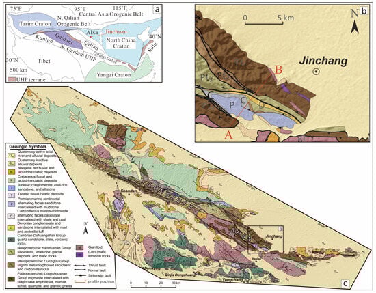
Figure 1.
(a) Sketch geological map showing tectonic location of Alxa Block [20,21]; (b) Study area; (c) Geological map of the Longshou shan, western China [22,23,24].
3. Stratigraphic Characteristics
Longshou Shan consists of a crystalline basement and an overlying sedimentary cover. The basement of Longshou Shan is represented by the Mesoproterozoic Longshoushan Group, with the primary exposed formations including the Baijiazui Group (Pt1b) and the Tamazigou Group (Pt1t). The overlying cover mainly consists of the Mesoproterozoic Dunzigou Group (Pt2dz), Neoproterozoic Hanmushan Group (Pt3hm), the Lower to Middle Devonian strata (D1-2), Upper Carboniferous strata (C3), and the Permian (P). To better understand the lithological and structural features of the region, a profile was measured within the study area, with the profile location shown in Figure 2. The lithostratigraphic characteristics are summarized in Table 1.
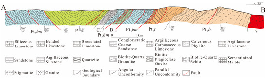
Figure 2.
Geological profile along AB line in Jinchuan area (location shown in Figure 1).

Table 1.
Lithological characteristics of strata in Jinchuan area.
Baijiazui Group (Pt1b): The main exposed lithology is a mix of gneiss with small amounts of serpentinized marble and tuff. It has been restored to a basaltic volcanic construction intercalated with some clastic rock formations.
Tamazigou Group (Pt1t): The main exposed lithology is quartzite, containing graphite marble and mica-quartz schist. This group belongs to a polygenic rock construction sedimentary sequence.
Dunzigou Group (Pt2dz): The profile measured in this study did not penetrate this formation, but data indicate that it lies in angular unconformity with the Tamazigou Group. The main exposed lithology includes quartz sandstone, conglomerate, and siliceous banded limestone [2].
Hanmushan Group (Pt3hm): The primary characteristic is the development of a grayish-white gravel-bearing sericite schist at the base. Additionally, limestone and magnetite-bearing quartzite are exposed in the upper layers. It is in contact with the underlying strata via a reverse fault.
Lower to Middle Devonian Strata (D1-2): These strata are mainly distributed in the intermontane basins and appear in a banded pattern. They are in fault contact with the Hanmushan Group. The main exposed lithology is sandstone and conglomerate, representing a terrestrial sedimentary sequence.
Upper Carboniferous Strata (C2): The main lithologies exposed are gravel-bearing sandstone, thick-bedded limestone, quartz sandstone, and carbonaceous schist.
Permian Strata (P): These strata are mainly exposed in the southern part of the study area, in parallel unconformity with the Carboniferous strata. The Permian is primarily composed of terrestrial clastic sediments, divided into the Lower Dahuanggou Group and the Upper Yaogou Group. The Dahuanggou Group is mainly composed of purple and gray fine-grained sandstones interbedded with quartz sandstone, with a thin layer of gravel-bearing sandstone at the base. The Yaogou Group is dominated by purple-red and light-red gravel-bearing coarse sandstone and conglomerate, interbedded with fine sandstone layers [25].
The Longshoushan Group, composed of the Baijiazui Group and the Tamazigou Group, is the oldest formation in the region, belonging to two different sedimentary constructions. Previous studies using isotopic dating methods suggest that its age ranges from 1914 to 2695 Ma [26], so it can be considered to date back to the Paleoproterozoic. It is part of the metamorphic basement of the Alxa block [27]. The Mesoproterozoic Dunzigou Group and the Neoproterozoic Hanmushan Group represent a rift-type sedimentary construction, mainly consisting of shallowly metamorphosed carbonates and clastic sedimentary rocks. They form the cover sediments over the crystalline basement and, together with the Longshoushan Group, constitute a binary structure similar to the basement of the Alxa block [28].
4. Analytical Methods and Results
To elucidate the tectonic evolution and deformation mechanisms of the northeastern margin of the Longshou Shan, this study conducted a systematic investigation and analysis of the joints, folds, and faults in the study area. Through detailed field measurements and the application of structural analysis methods such as equal-area stereographic projection, the main structural types, along with their geometric and kinematic characteristics, were identified [10,12]. This section provides a comprehensive account of the joint, fold, and fault structures developed in the major stratigraphic units of the region, offering critical support for the reconstruction of the regional principal stress field and the analysis of tectonic evolution.
4.1. Joint Structures
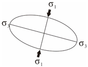
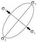
Conjugate joints are a common brittle structure type in shallow surface layers and can effectively reflect the characteristics of the tectonic stress field in a specific region [7,29,30]. Conjugate shear joints refer to fractures formed by shear stress, often appearing in pairs and cutting across each other. The bisector of the acute angle formed by two sets of joints represents σ1, the intersection line represents σ2, and the bisector of the obtuse angle represents σ3. The relationship between conjugate shear joints and principal stress is the basis for joint stage matching and serves as the foundation for analyzing the principal stress field in the study area.
Figure 3 shows four sets of conjugate shear joints measured in the Baijiazui Group, Tamazigou Group, and Hanmushan Group formations. These joints typically feature flat surfaces, good continuity, and stable orientations, with both oblique and nearly vertical joints being well developed. The joints exhibit no significant deformation or signs of recrystallization, indicating that they formed after regional metamorphism. They represent brittle structures formed in hardened, cooled rocks, reflecting the influence of a later-stage tectonic stress field. The direction of the principal stress was determined using the equal-area projection method, and the results are shown in Table 2. Based on the calculated maximum principal stress (σ1), the joint arrangement can be divided into three groups—near NS (196°), near EW (269°), and NW (132°, 306°). According to the relationship between the maximum principal stress direction (σ1), tectonic sequences, and their alignment, three periods of tectonic stress activity can be identified.
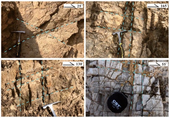
Figure 3.
Conjugate shear joints (dashed lines).
Table 2.
Statistics of conjugate shear joints and their principal stresses.
4.2. Folding Structures
The structural evolution of the Longshou Shan fold belt is controlled by the convergence and evolution of the North China Plate and the South China Plate. The current structural framework is the result of multiple stages of tectonic superposition [31]. The main structural trend of the folds in the study area is NW-oriented. Based on field investigations, the deformed strata involved in folding in the Jinchuan area include the Tamazigou Formation, the Hanmushan Group, and the Permian system.
Figure 4a shows a syncline structure in the Tamazigou Group. The northern flank has an orientation of 200°∠75°, while the southern flank has an orientation of 70°∠30°, displaying a steep northern flank and a gentle southern flank. The interlimb angle is 85°. Using the orientation of the two flanks, the fold axis orientation is determined by the equal-area projection method to be 37°∠66°, indicating an oblique open fold. Figure 4b shows an anticline-syncline pair. Based on the orientations of the two flanks, the axial plane of the anticline is 246°∠55°, and the axial plane of the syncline is 243°∠65°. Figure 4c presents an anticline structure in the Tamazigou Group, with the northern flank having an orientation of 12°∠75° and the southern flank having an orientation of 202°∠47°. The interlimb angle is 58°, and the axial plane is 196°∠76°, nearly upright, indicating an upright and regular fold. In addition, box folds are also developed in the Tamazigou Group (Figure 4g). Figure 4d shows an anticline in the Hanmushan Group, where the northern flank has an orientation of 60°∠53°, and the southern flank has an orientation of 48°∠81°. This structure displays a gentle northern flank and a steep southern flank, with the southern flank overturned, indicating an oblique fold. The axial plane orientation is 53°∠67°. Permian strata develop an anticline-syncline pair (Figure 2). Field measurements show that the southern flank of the syncline has an orientation of 60°∠28°, while the northern flank has an orientation of 155°∠18°, with both flanks having similar dip angles, indicating an upright fold. Using the equal-area projection method, the axial plane orientation was determined to be 208°∠83°. Figure 5 presents the equal-area projection results of the axial plane orientations obtained for the folds in the Tamazigou Group, Hanmushan Group, and Permian strata. The fold axis orientations in these strata are primarily NW-oriented, which is consistent with the regional structural trend, and formed under an NE-SW-directed compressional environment.
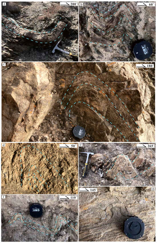
Figure 4.
Fold Structures in Jinchuan Area (dashed lines). (a): Syncline in Tamazigou Formation; (b): Fold in Tamazigou Formation; (c): Anticline in Tamazigou Formation; (d): Synformal fold in Hanmushan Group; (e): Fold in Tamazigou Formation; (f): Asymmetric fold in Tamazigou Formation; (g): Box fold in Tamazigou Formation.
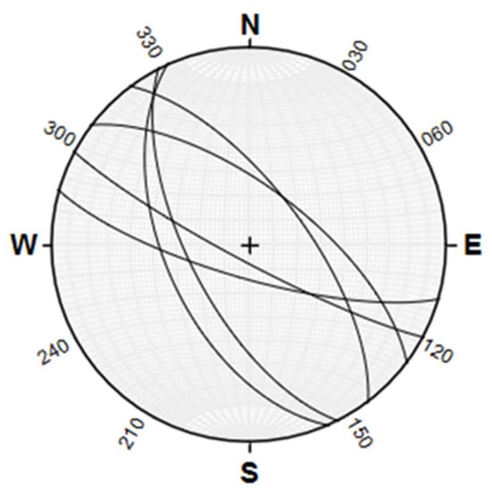
Figure 5.
Stereographic projection of fold axial planes in Jinchuan Area (n = 6, planer, lower hemisphere).
4.3. Fault Structures
The fault structures in the study area are well developed (Figure 6). Based on the cutting relationships between the faults, three stages of fault activities can be inferred. The first stage is represented by the northwestward-directed fault F1. The second stage involves northeastward-directed faults, such as F8 and F16-1 (locally transitioning to a near east-west direction), characterized by left-lateral strike-slip faulting. This stage represents post-mineralization tectonics, altering the shape of the ore body. The third stage is represented by the northeastward-directed fault F17 [6]. The northeast-southwest-directed faults exhibit shear characteristics, with evidence of shear deformation found in both diabase dikes and strata (Figure 7e,f).
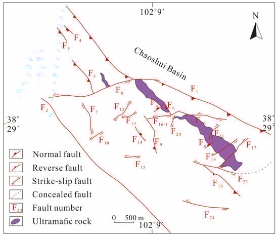
Figure 6.
Schematic map of fault structures in Jinchuan area [5,6].
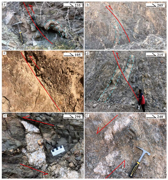
Figure 7.
Fault structures in Jinchuan area. ((a): Reverse fault developed in basalt dike of Baijiazui Formation; (b): Reverse fault in Baijiazui Formation; (c): Reverse fault in Carboniferous; (d): Reverse fault in Hanmushan Group; (e): Quartz shear deformation in basalt dike; (f): Quartz vein shear deformation in quartzite; The blue dashed lines represent bedding planes; The red solid lines indicate faults; The arrows show the direction of movement).
In the fieldwork, NW-trending faults were predominantly observed, and the orientations of some of these faults were measured (Figure 7). Figure 7a shows a fault developed in the basalt dike of the Baijiazui Formation, with a strike of 245° and a dip of 50°. Fault gouge is developed along the fault, and the reverse fault is inferred from the drag folds formed by the bending of the hanging wall strata. Figure 7b presents a fault developed in the Baijiazui Formation. Based on the strike and dip of the lithologies on both sides, the fault is inferred to be a reverse fault. The fault is filled with basalt dike, and the rocks on both sides are mica-quartz schist. Figure 7c shows a fault developed in the Carboniferous strata, with a strike of 75° and a dip of 54°. The fault is inferred to be a reverse fault based on the directional arrangement of the gravel on both sides of the fault. Figure 7d presents a reverse fault developed in the limestone of the Hanmushan Group, with a strike of 215° and a dip of 62°. Field measurements of the reverse fault’s attitude, projected on the equal-area stereonet, show that the faults in this region are primarily formed under NE-SW compression stress (Figure 8).
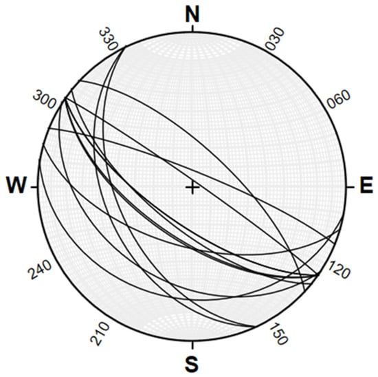
Figure 8.
Stereographic projection of fault attitudes in Jinchuan area. (n = 11, planer, lower hemisphere).
5. Discussion
5.1. Structural Stress Field Analysis
Based on the conjugate shear joints, folds, and fault stereographic projection results mentioned above, as well as the regional tectonic evolution history and previous research findings, the tectonic stress field evolution in the study area is summarized in Table 3. A detailed analysis is as follows:
Table 3.
Tectonic stress field evolution on northeastern margin of Longshou Shan (modified from [3,4,5,6]).
Proterozoic Era: During the Proterozoic, the ancient tectonic stress field in the study area was primarily characterized by near-NS-directed compression. In the Longshou Shan area, a series of east-west-oriented compound anticlines and east-west compressive faults were formed [32].
Middle to Late Neoproterozoic: With the breakup of the Rodinia supercontinent, the ancient tectonic stress field in the study area was primarily characterized by EW compression. The region was in an extensional environment, which created favorable conditions for the intrusion of ultramafic rock bodies [32,33].
Early Paleozoic Era: During this period, the study area was characterized by NS compression. At this time, the closure of the Qilian Ocean occurred, and the Longshou Shan region underwent intracontinental orogenesis [31,34].
Late Paleozoic Era: In the late Paleozoic, the main feature of the tectonic stress field was near NNE-SSW compression. During this time, intracontinental thrust orogenesis occurred, leading to the formation of the continental crust [4].
Mid-Mesozoic Era: In the mid-Mesozoic, the study area was characterized by NW-SE compression. In the early to middle Jurassic, the compressional effects caused by the collision of the southern margin of the Eurasian plate weakened, and the Alxa block experienced regional extension [35]. During this stage, northeast-striking strike-slip faults and northwest-striking thrust faults developed in the mining area [5].
Late Mesozoic to Cenozoic Era: During this period, the study area was characterized by NE-SW compression, and the previously formed faults were reactivated. The F1 and F2 faults exhibited characteristics of compressional reverse-thrust faults. The hanging wall of the F1 fault displaced the Neoproterozoic strata over Quaternary gravel layers, and the Jinchuan ore deposit was uplifted from depth to the surface [19].
5.2. Tectonic Evolution Stages
- (1)
- Proterozoic to Mid-Neoproterozoic
Guan et al. [36] believed that a strong metamorphic deep-melting event occurred in the Longshou Shan area during the late Proterozoic, possibly related to collision orogenesis. Before the Proterozoic, the foreland basin sedimentation ended, the crust rose, and tectonic activity intensified. Under the influence of near SN-directed tectonic stress, the Longshou Shan region formed a series of east-west-oriented anticline-syncline pair and compressional faults [32]. Prior to the Mesozoic, the early period was dominated by an SN-directed compressive stress field, forming east-west structural features under NE-SW shear stress. Later, EW-directed compressional activity prevailed, forming a series of near north-south structural belts [3]. During the Lüliang Orogeny, a large number of granite veins developed in the study area, with early deep magmatic activity in the Mid-Neoproterozoic, leading to regional uplift and intense erosion.
- (2)
- Middle to Late Neoproterozoic
After the Lüliang Orogeny, the crust subsided into the ocean. Under the influence of near EW-directed compression, a series of north-south structures formed in the region, modifying the earlier formed EW-directed structures, and east-west faults developed, forming extensional structures [32].
During the Middle Neoproterozoic, the lower part of the Dunzigou Group formed molasse-type deposits and shallow marine terrestrial sequences in the upper part, reflecting the characteristics of rifting [4]. Tung et al. [33] also confirmed that during the Middle Neoproterozoic, the Longshou Shan area was in a rift environment with associated magmatic activity. Additionally, a set of gravelly dolostones widely distributed along the uplift direction at the base of the Neoproterozoic strata in the Longshou Shan area suggests that the region was in a continental rift environment, providing favorable structural conditions for magmatic intrusion and sulfide mineralization [37]. Li et al. [38] obtained a zircon U-Pb age of 827 ± 8 Ma for the ultramafic rocks in the Jinchuan region. Therefore, by the mid-Neoproterozoic (~830 Ma), influenced by the Rodinia supercontinent breakup, the Jinchuan region’s mineralized ultramafic bodies intruded into the Baijiazui Formation, forming super-large sulfide deposits [37,39]. Later, under continued EW-directed pressure, the intrusive bodies were reoriented to a northwest direction.
In the late Neoproterozoic, the subduction of the Qilian Ocean beneath the North China Plate transformed the southwestern margin of the North China Plate from a passive continental margin to an active continental margin. At this time, the study area entered the compressional phase, and the tectonic stress became primarily compressive [32,40].
- (3)
- Early Paleozoic
During the early Paleozoic phase, intracontinental orogenesis occurred in Longshou Shan, forming detachment structures that caused the absence of Cambrian, Ordovician, and Silurian strata in the southern part of the mining area. A large number of diabase veins, porphyry veins, and granite veins intruded [19]. Zhang et al. [41] studied the vein rocks in the Jinchuan region and pointed out that the closure of the Qilian Ocean occurred around 445 Ma. Afterward, the Qilian-Qaidam Block and the Alxa Block underwent continental-continental collision, with subduction lasting until 390 Ma, followed by slab detachment and retreat. Zhang et al. [42] studied Silurian A-type granite (427.2 ± 2.2 Ma) in the south of Longshou Shan and speculated that the North Qilian Orogenic Belt and adjacent regions entered the post-collision extension phase during the Middle Silurian to Early Devonian. Chen et al. [43] studied the grayish-white medium-coarse-grained quartz monzonite (447.0 ± 5.2 Ma) in the Jiling Granite Body of the Niujiaogou area of Longshou Shan and suggested that, during the Late Ordovician, the northern Qilian oceanic crust subducted northward, and then the North Qilian island arc and Alxa Block transitioned into the continental-continental collision phase. Chen et al. [34] measured the fine-grained granite age in the Zhongpai area of Longshou Shan to be 413.7 ± 3.0 Ma, which is a product of early Devonian magmatic activity. Based on previous research, it is believed that the subduction phase of Longshou Shan during the Paleozoic lasted from 452 to 438 Ma, with the post-collision phase from 430 to 412 Ma. Therefore, during the early Paleozoic period, the northern and southern continents collided, accompanied by south-to-north thrust structures. Longshou Shan was in a compressional tectonic environment, forming the Longshou Shan thrust structures, and the Jinchuan deposit was uplifted as a result of the thrusting [31]. By the early Paleozoic period, Longshou Shan was in the post-collision stage.
- (4)
- Late Paleozoic
Located on the northern side of the Qilian Orogenic Belt, Longshou Shan transitioned from an extensional rift environment—from the Late Silurian to Early Devonian—to an intraplate compressional environment by the Middle Devonian. During this period, the compressive stress was NNE-SSW [4]. After the closure of the Qilian Ocean in the Late Devonian, the Qilian-Qaidam Block continued to subduct beneath the Alxa Block, and Longshou Shan entered a compressional environment, undergoing large-scale compressional orogenesis, manifested as northeastward thrusting [19]. At the same time, the region’s crust experienced significant vertical uplift, and the Jinchuan ore body moved from depth to the surface [2].
- (5)
- Mesozoic to Cenozoic
Since the Mesozoic-Cenozoic, with the continuous expansion of the Tibetan Plateau toward the NE, Longshou Shan has been in a strong NE-SW compressional environment. During this period, a set of NEE-striking strike-slip faults began to develop, causing the mineralized bodies to be divided into independent blocks. The F1 fault on the northern side of the mining area became reactivated, causing the hanging wall mineralized geological body and surrounding rock to be thrust to the NE, overlying the Cenozoic sediments [5]. During the Late Jurassic, the Alxa Block began to slowly uplift under NE-SW compression. This may have been the result of the combined effects of various tectonic events, such as the closure of the Mongol-Okhotsk Ocean and the westward subduction of the ancient Pacific plate [44]. During this stage, Longshou Shan was thrust in the northeast direction, forming a series of northwest-striking reverse faults and NW-SE-tight folds, causing the ore body to shorten in the northeast direction [45].
The southern margin of the Alxa Block, under strong compression processes controlled by two stages of compression from the south, began to undergo significant exhumation in the Late Cretaceous (~130 Ma) [34]. Lei [15] used apatite fission track analysis to restore the thermal history of the eastern Longshou Shan region, showing that the area experienced two cooling phases from the Early Jurassic (~200 Ma) to the Early Cretaceous (~100 Ma) and the Miocene (~15 Ma). From the Late Cretaceous (~100 Ma) to the Miocene (~15 Ma), the region was in a tectonically stable period. The intense uplift of East Longshou Shan during the Jurassic (200–100 Ma) was related to the closure of the Neo-Tethys Ocean and the convergence of the southern Qiangtang Block of the Eurasian continent, possibly as a distant response to these events. Since the Miocene (~15 Ma), the northeastern Longshou Shan area, where the Jinchuan deposit is located, has experienced independent and intense uplift, possibly related to the far-field effect of the India-Eurasia plate collision. Zhao [46] studied the apatite fission track data in the Longshou Shan area and found that the study area was tectonically stable from the late Mesozoic to the late Miocene, with no significant uplift. In the early Miocene (~15–20 Ma), influenced by the Himalayan tectonic domain, NE-SW compressional structural deformation developed, marking the first cooling and uplift of Longshou Shan in the Cenozoic. Later, during the Pliocene (~5 Ma) and the late Pliocene (~2.5 Ma), the area underwent the second and third phases of rapid tectonic uplift. Dong et al. [47] used valley data to calculate the principal compressive stress direction in the Longshou Shan area, indicating that since the late Tertiary, the principal compressive stress in the region has been oriented to the NE, with a relatively stable tectonic stress field, which is the result of the interaction between the Qinghai-Tibet Block and the Alxa Block.
6. Conclusions
- The northeastern margin of Longshou Shan has experienced six phases of maximum principal stress direction changes—approximately NS → EW → NS → NNE-SSW → NW-SE → NE-SW.
- Stress regimes and their geological responses in different tectonic stages are as follows:
(1) Paleoproterozoic to Mesoproterozoic: The Longshou Shan area was mainly controlled by nearly SN-oriented compressive stress, leading to the development of a series of east-west-trending composite anticlines and compressional faults. This period was marked by intense metamorphism, magmatic activity, and erosion, laying a solid foundation for subsequent tectonic evolution.
(2) Early Mesoproterozoic to Neoproterozoic: Following the Lüliang Orogeny, the crust subsided into a rift-related extensional setting. Influenced by the breakup of the Rodinia supercontinent, ultramafic intrusions emplaced in the Jinchuan area, resulting in the formation of a world-class sulfide deposit. The regional stress regime gradually transitioned to a nearly EW-oriented compressive setting.
(3) Early Paleozoic: The early Paleozoic Orogeny triggered intracontinental orogeny, characterized by NS-directed compressive stress. This led to the development of thrust structures and widespread intrusion of mafic and felsic dikes. During this stage, the Jinchuan ore body experienced significant uplift.
(4) Late Paleozoic: During the Hercynian stage, the closure of the Qilian Ocean brought the region back into a compressive regime, with a dominant NNE-SSW-oriented principal stress field. This resulted in NE-directed thrusting structures, further facilitating the upward movement of the ore bodies.
(5) Mesozoic to Cenozoic (Himalayan Stage): Under the combined influence of the closure of the Mongol-Okhotsk Ocean, the westward subduction of the Paleo-Pacific Plate, and the eastward expansion of the Tibetan Plateau, the tectonic evolution became increasingly complex. The principal stress field evolved from NW-SE to NE-SW orientations. The Longshou Shan area entered a compressional uplift phase dominated by NE-directed stress, which promoted the exposure of ore bodies at the surface.
Author Contributions
Conceptualization, Z.L. and G.G.; methodology, K.S.; software, J.X.; validation, W.Z. and R.D.; formal analysis, K.Y.; investigation, D.J.; data curation, Z.L.; writing—original draft preparation, Z.L.; writing—review and editing, Z.L., G.G. and K.S.; visualization, J.X.; supervision, K.Y. All authors have read and agreed to the published version of the manuscript.
Funding
This research was funded by the Program of China Geological Survey (project numbers DD20243184, DD20243187, DD20240019).
Data Availability Statement
The original contributions presented in this study are included in the article. Further inquiries can be directed to the corresponding authors.
Conflicts of Interest
The authors declare no conflicts of interest.
References
- Wu, Y.Z.; Qiao, G.B.; Chen, D.H. A preliminary study on relationship between tectonic magmatism and mineralization in Qimantage area, Eastern Kunlun mountains. Geotecton. Metallog. 2011, 35, 232–241. [Google Scholar]
- Zeng, R.Y. Magma Conduit System and Magmatic Evolution of Jinchuan Cu–Ni Sulfide Deposit. Master’s Thesis, Central South University, Changsha, China, 2014. [Google Scholar]
- Liao, W.J. Tectonic Lithofacies Mapping, Stress Field Analysis and the Deep Metallogenetic Prognosis in Jinchuan Copper and Nickel Orefield. Master’s Thesis, China University of Geosciences (Beijing), Beijing, China, 2016. [Google Scholar]
- He, Q.J.; Lai, J.Q.; Mao, X.C.; Xiao, W.Z.; Ai, Q.X.; Liu, Y.; Du, R.J. Tectonic stress field and tectonic evolution in Jinchuan mining district, Gansu province. Contrib. Geol. Miner. Resour. Res. 2019, 34, 265–273. [Google Scholar]
- Zhao, Y.F.; Shi, W.; Zhang, Y. Study on the reconstruction of the paleo–tectonic stress field and its evolution in the Jinchuan mining district, Gansu province. J. Geomech. 2023, 29, 770–785. [Google Scholar]
- Jiao, J.G.; Tan, F.; Li, L.N.; Liu, J.; Yang, X.K.; Gao, D. Observation and analysis of diagenesis and mineralization structures of the Jinchuan Cu–Ni sulfide deposit in Gansu. Geoscience 2024, 38, 1026–1042. [Google Scholar]
- Sanità, E.; Lardeaux, J.M.; Marroni, M.; Gosso, G.; Pandolfi, L. Structural relationships between Helminthoid Flysch and Briançonnais Units in the Marguareis Massif: A key for deciphering the finite strain pattern in the external southwestern Alps. Geol. J. 2020, 56, 2024–2040. [Google Scholar] [CrossRef]
- Sanità, E.; Lardeaux, J.M.; Marroni, M.; Gosso, G.; Pandolfi, L. Deciphering large–scale superposed fold systems at shallow crustal levels in collision zones: Insights from the Marguareis Massif (southwestern Alps). J. Maps 2021, 17, 559–568. [Google Scholar] [CrossRef]
- Di Rosa, M.; Sanità, E.; Frassi, C.; Lardeaux, J.M.; Corsini, M.; Marroni, M.; Pandolfi, L. A journey of the continental crust to and from mantle depth: The P–T–t–d path of Venaco unit, Alpine Corsica (France). Geol. J. 2023, 59, 422–440. [Google Scholar] [CrossRef]
- Frassi, C.; Ottria, G.; Ferdeghini, A. Fault tectonics of the Tuscan Nappe in the eastern sector of the Apuan Alps (Italy). J. Maps 2020, 16, 745–754. [Google Scholar] [CrossRef]
- Filimon, D.I.; Vannucci, G.; La Rosa, A.; Zarone, V.; Di Rosa, M. The geological setting of Matra ore deposit (France): Insights from lithostratigraphy and polyphase deformation history. J. Maps 2024, 20, 2394502. [Google Scholar] [CrossRef]
- Sanità, E.; Di Rosa, M.; Lardeaux, J.M.; Marroni, M.; Pandolfi, L. The Moglio–Testico Unit (Ligurian Alps, Italy) as Subducted Metamorphic Oceanic Fragment: Stratigraphic, Structural and Metamorphic Constraints. Minerals 2022, 12, 1343. [Google Scholar] [CrossRef]
- Sanità, E.; Di Rosa, M.; Lardeaux, J.M.; Marroni, M.; Pandolfi, L. Tectonic coupling of oceanic and continental units in the Southwestern Alps (Western Liguria, Italy) revealed by structural mapping. J. Maps 2023, 19, 2214789. [Google Scholar] [CrossRef]
- Cesari, F.D.; Di Rosa, M.; Sanità, E.; Pandolfi, L.; Marroni, M. Long–lived sedimentation in the Western Tethys oceanic basin: Revisiting the metasediments of Bagliacone–Riventosa Formation (Corsica, France). Int. Geol. Rev. 2024, 67, 906–932. [Google Scholar] [CrossRef]
- Lei, X.H. Uplift–Cooling Evolution of the East Longshou Mountain and Its Influence on Denudation and Preservation of the Jinchuan Deposit. Master’s Thesis, Chang’an University, Xi’an, China, 2023. [Google Scholar]
- Tang, Z.L.; Yan, H.Q.; Jiao, J.G.; Li, X.H. New classification of magmatic sulfide deposits in China and ore–forming processes of small intrusive bodies. Miner. Depos. 2006, 25, 1–9. [Google Scholar]
- Yu, C.D.; Wang, K.X.; Liu, X.D.; Cuney, M.; Pan, J.Y.; Wang, G.; Zhang, L.; Zhang, J. Uranium mineralogical and chemical features of the Na–metasomatic type uranium deposit in the Longshoushan metallogenic belt, Northwestern China. Minerals 2020, 10, 335. [Google Scholar] [CrossRef]
- Zeng, R.Y.; Lai, J.Q.; Mao, X.C.; Yan, J.; Zhang, C.G.; Xiao, W.Z. Geochemistry and zircon ages of the Yushigou diabase in the Longshoushan area, Alxa Block: Implications for crust–mantle interaction and tectonic evolution. Geol. Mag. 2021, 158, 685–700. [Google Scholar] [CrossRef]
- Liu, J. Tectonic Evolution and Metallogenic Prognosis of Jinchuan Copper–Nickel Sulfide Deposit in Gansu. Master’s Thesis, Chang’an University, Xi’an, China, 2022. [Google Scholar]
- Zeng, R.Y.; Su, H.; Allen, M.B.; Shi, H.Y.; Du, H.F.; Zhang, C.G.; Yan, J. Petrogenesis of early Paleozoic I–type granitoids in the Longshoushan and implications for the tectonic affinity and evolution of the southwestern Alxa Block. Solid Earth 2025, 16, 179–196. [Google Scholar] [CrossRef]
- Song, S.G.; Niu, Y.L.; Su, L.; Xia, X.H. Tectonics of the north Qilian orogen, NW China. Gondwana Res. 2013, 23, 1378–1401. [Google Scholar] [CrossRef]
- Wu, C.; Li, J.; Zuza, A.V.; Haproff, P.J.; Yin, A.; Ding, L. Paleoproterozoic–Paleozoic tectonic evolution of the Longshou Shan, western North China craton. Geosphere 2022, 18, 1177–1193. [Google Scholar] [CrossRef]
- Wu, C.; Zuza, A.V.; Yin, A.; Chen, X.H.; Haproff, P.J.; Li, J.; Li, B.; Ding, L. Punctuated orogeny during the assembly of Asia: Tectonostratigraphic evolution of the North China craton and the Qilian Shan from the Paleoproterozoic to early Paleozoic. Tectonics 2021, 40, e2020TC006503. [Google Scholar] [CrossRef]
- Gong, J.H.; Zhang, J.X.; Wang, Z.Q.; Yu, S.Y.; Li, H.K.; Li, Y.S. Origin of the Alxa Block, western China: New evidence from zircon U–Pb geochronology and Hf isotopes of the Longshoushan Complex. Gondwana Res. 2016, 36, 359–375. [Google Scholar] [CrossRef]
- Zhang, B.H. Late Mesozoic–Cenozoic Tectonic Evolution of the Northern Hexi Corridor. Master’s Thesis, China University of Geosciences (Beijing), Beijing, China, 2016. [Google Scholar]
- Xiu, Q.Y.; Yu, H.F.; Li, Q.; Zuo, G.C.; Li, J.W.; Cao, C.J. Discusstion on the petrogenic time of Longshoushan group, Gansu province. Acta Geol. Sin. 2024, 78, 366–373. [Google Scholar]
- Liu, X.Y.; Wang, Q. Tectonics of the Longshoushan ancient rift and Hexi corridor. Bull. Chin. Acad. Geol. Sci. 1993, 1–14. [Google Scholar]
- Gong, J.H.; Zhang, J.X.; Yu, S.Y. The origin of Longshoushan Group and associated rocks in the southern part of the Alxa block: Constraint from LA–ICP–MS U–Pb zircon dating. Acta Petrol. Mineral. 2011, 30, 795–818. [Google Scholar]
- Eyal, Y.; Gross, M.R.; Engelder, T.; Becker, A. Joint development during fluctuation of the regional stress field in southern Israel. J. Struct. Geol. 2001, 23, 279–296. [Google Scholar] [CrossRef]
- Xiao, F.F.; Hou, G.T.; Wang, Y.X.; Li, L. Study on structural stress fields since Permian, Junggar basin and adjacent areas. Acta Sci. Nat. Univ. Pekin. 2010, 46, 224–230. [Google Scholar]
- Ma, J.H. Jinchuan Mining Ductile Shear Zone Characteristics and Its Significance. Master’s Thesis, Chang’an University, Xi’an, China, 2009. [Google Scholar]
- Li, Z. Analysis on the Ore–Controlling Tectonic in Jinchuan Copper–Nickel Sulphide Deposit, Gansu Province. Master’s Thesis, Central South University, Changsha, China, 2009. [Google Scholar]
- Tung, K.A.; Yang, H.Y.; Liu, D.Y.; Zhang, J.X.; Tseng, C.Y.; Wan, Y.S. SHRIMP U–Pb geochronology of the detrital zircons from the Longshoushan Group and its tectonic significance. Chin. Sci. Bull. 2007, 52, 1414–1425. [Google Scholar] [CrossRef]
- Chen, Y.X.; Liu, W.H.; Wang, K.X.; Liu, X.D.; Sun, L.Q.; Yin, D.H. Petrogenesis and tectonic implications of the Zhongpai fine–grained granite in the Qingshanbao, Gansu province: Constraints by zircon U–Pb chronology and geochemistry. Geoscience 2024, 38, 169–182. [Google Scholar]
- Zhang, J.; Wang, Y.N.; Qu, J.F.; Zhang, B.H.; Zhao, H.; Yun, L.; Li, T.Y.; Niu, P.F.; Nie, F.J.; Hui, J.; et al. Mesozoic intracontinental deformation of the Alxa Block in the middle part of Central Asian Orogenic Belt: A review. Int. Geol. Rev. 2021, 63, 1490–1520. [Google Scholar] [CrossRef]
- Guan, Y.H.; Zeng, R.Y.; Lai, J.Q.; Mao, X.C.; Su, H. Late Paleoproterozoic metamorphic–anatexis and their tectonic implications in the Longshoushan area, Alxa block. Earth Sci. 2023, 48, 4034–4052. [Google Scholar]
- Wang, R. Reconstruction of the Original Field Relationship of the Jinchuan Intrusion. Master’s Thesis, China University of Geosciences (Beijing), Beijing, China, 2016. [Google Scholar]
- Li, X.H.; Su, L.; Chung, S.L.; Li, Z.X.; Liu, Y.; Song, B.; Liu, D.Y. Formation of the Jinchuan ultramafic intrusion and associated world–class Ni–Cu sulfide deposit by the 825Ma South China mantle plume? Geochem. Geophys. GeoSyst. 2006, 6, Q11004. [Google Scholar]
- Zhang, M.J.; Kamo, S.L.; Li, C.S.; Hu, P.Q.; Ripley, E.M. Precise U–Pb zircon–baddeleyite age of the Jinchuan sulfide ore–bearing ultramafic intrusion, western China. Miner. Depos. 2010, 45, 3–9. [Google Scholar] [CrossRef]
- Tang, Z.L.; Bai, Y.L. The geotectonic setting of the large and superlange mineral deposits in the southwest margin of NorthChina paleoplate. Acta Geol. Gansu 2002, 9, 1–15. [Google Scholar]
- Zhang, K.; Jiao, J.G.; Liu, Q.; Ma, Y.J.; Duan, J.; Zhao, L.D.; Jia, L.; Liu, J. Uplift of Paleozoic magmatic core complex in the Longshoushan area, Gansu: Evidence from geochronology and geochemistry of rock veins in the Jinchuan deposit area. Geol. Bull. China 2023, 42, 343–362. [Google Scholar]
- Zhang, Z.G.; Tang, G.Q.; Liu, X.J.; Yang, Y.H.; Xiao, R.; Li, D.C.; Tian, H. Genesis and geodynamic significance of Silurian A–type granites in the Shandan area, southern Longshoushan, Gansu. Geochimica 2025, 54, 100–113. [Google Scholar]
- Chen, Y.J.; Zhao, R.Y.; Wang, G.; Rong, X.; Li, T. Geochronology, geochemical characteristics and significances of quartz monzonite in Niujiaogou, Longshoushan, Gansu. J. East China Univ. Technol. (Nat. Sci.) 2020, 43, 21–29. [Google Scholar]
- Zhang, B.H.; Zhang, J.; Wang, Y.N.; Zhao, H.; Li, Y.F. Late Mesozoic–Cenozoic Exhumation of the Northern Hexi Corridor: Constrained by Apatite Fission Track Ages of the Longshoushan. Acta Geol. Sin. (Engl. Ed.) 2017, 91, 1624–1643. [Google Scholar] [CrossRef]
- Yu, J.X. Active Tectonics in the Southern Gobi–Alashan Block and Its Response to the Interactions of the Adjacent Crustal Blocks. Ph.D. Thesis, Institute of Geology, China Earthquake Administration, Beijing, China, 2016. [Google Scholar]
- Zhao, D. Cenozoic Tectonic Evolution of the Longshou Shan Area and Its Adjacent Regions, Northeast Margin of the Tibetan Plateau. Ph.D. Thesis, Chang’an University, Xi’an, China, 2024. [Google Scholar]
- Dong, Z.P.; Zhao, T.S.; Dai, W.; Chen, Y.; Zheng, T.X.; Liu, C.C. Preliminary study on the geotectonic stress field in the LongshoushanMt. South China J. Selsmology 2005, 25, 1–7. [Google Scholar]


Disclaimer/Publisher’s Note: The statements, opinions and data contained in all publications are solely those of the individual author(s) and contributor(s) and not of MDPI and/or the editor(s). MDPI and/or the editor(s) disclaim responsibility for any injury to people or property resulting from any ideas, methods, instructions or products referred to in the content. |
© 2025 by the authors. Licensee MDPI, Basel, Switzerland. This article is an open access article distributed under the terms and conditions of the Creative Commons Attribution (CC BY) license (https://creativecommons.org/licenses/by/4.0/).