Abstract
Rapid urbanization has led vertical infrastructural growth in different countries with differing economic development levels and social systems. The two cities, Prague and Delhi, are the capital cities of their respective countries and have significant vertical developments. However, the two cities represent the urban areas from countries having different economic development levels. The land agencies need to keep monitoring and managing the developments in a city. The paper proposes a conceptual 3D spatial database enabled IT framework for land agencies. A monostrand multiple case study approach reviews the current practices, existing spatial data systems and programmes with 3D components, initiatives taken to create digital spatial database and potential for 3D spatial database in the two cities. The policy drivers for creation and use of 3D spatial database for land agencies are presented. The current legal and planning landscape and the institutional arrangements related to land and property development have been studied considering the scope for the development of 3D data. Further, a conceptual 3D spatial database enabled IT framework for better land administration, planning, development and management functioning is proposed. The proposed framework can make a difference providing interconnectivity, ease of access and usage, time and cost efficiency, enhanced organizational coordination and spatial data information-based decision-making process.
1. Introduction
Rapid urbanization is a global phenomenon spreading out in the developing world. Several countries in Asia and Africa are examples of it such as Kigali in Rwanda [], Accra in Ghana [], Bengaluru in India [] and Shenjiang in China []. The expansion in densely populated cities with demand for space is not only horizontal but also vertical, increasing the infrastructural complexity [,]. This vertical growth of infrastructure and its densification are consuming space both above and below the ground in the form of multi-storey or high-rise buildings and laying down of underground or elevated utility networks in the form of pipelines, elevated roads, flyovers, metro tunnels, electricity wires, optical fibres etc.
The rapid growth of cities in developing countries may find the land planning, development and management agencies often unprepared for assessing, preparing for and meeting the demands of rapid urbanization. This unpreparedness could be in the form of information required about different types of land tenure, property valuation and taxation, possibilities of physical extensions, etc. []. The traditional form of 2D-based land cadastre might not be sufficient to provide the required clarity about Rights, Restrictions and Responsibilities (RRRs) into multi-storey or high-rise buildings [,]. This type of buildings could have individual condominiums and common space with exclusive rights and common rights []. To provide the required clarity about the physical and legal aspects for the users as owners, valuators, insurers and investors, it is important to have a 3D information enabled representation of physical and legal aspects of exclusive and common ownership areas [,,].
The modern city planning for urban development requires mass scale 3D spatial data enabled models for planning and changes in city landscape [] for ensuring the required transparency through participation of various stakeholders. The planned development of cities requires 3D digital designing of multi-storey and high-rise buildings construction. Modern complex structures require Building Information Management (BIM) to enhance efficiency in designing and construction works [,]. After development of an urban extension or settlement, land and property management of the newly developed area is required. Monitoring of the new properties for extensions and encroachments is required to maintain the planned and unplanned landscape of the city. Regular and transparent updates of land records and the successive transactions in a secure and transparent manner is required for this purpose. The updated data of legally valid and approved structural changes as building plan approvals and extension approvals is required.
The paper proposes a conceptual 3D spatial database enabled IT framework for land agencies. The two cities, Delhi in India and Prague in Czech Republic, are taken as case study examples because of the existing similarities and differences between the two. Both are the capital cities of their respective countries and have significant vertical developments. However, the two cities represent the urban areas from countries having different economic development levels. Delhi is a metropolitan city of India, a rapidly growing developing economy and with a huge population, estimated to be more than 20 million. However, India’s per capita income is approximately 2100 USD per annum, while the per capita income of Czech Republic is approximately 24,000 USD per annum []. Infrastructure requirements in India are huge, and, currently, Prague is a metropolitan city of Czech Republic, a developed economy and a part of European Union. The two cities are located in different continents of the earth. Indian real GDP growth was reduced to 4.2 in financial year 19/20 caused by the long-standing structural rigidities in key input markets, continuing balance sheet stress in the banking and corporate sector. This has been enhanced by the stress in the non-banking segment of the financial sector, increased risk aversion among banks and corporates and a decline in rural demand []. In the case of Prague, the economy performed strongly in the pre-covid crisis period which led to the convergence in incomes and living standards [].
This study explores the answer to these questions: (1) what are the current practices, data systems and policy drivers for the land agencies related to the 3D information in Delhi and Prague? (2) what kind of current legal, planning and organizational provisions related to 3D concepts exist in Delhi and Prague for land agencies? (3) what kind of 3D spatial database enabled IT framework could be adopted to enhance effectiveness of land administration, planning, development and management for cities with similar characteristics?
2. Materials and Methods
The paper explores the opportunities that can be provided by 3D spatial database for enhancing the effectiveness of land administration, planning, development and management in urban areas. It explores, as shown in the Figure 1, the current practices, existing data systems based state-of-the-art and potential for 3D spatial database. A monostrand multiple case study approach has been applied, which allows performing qualitative analysis in depth of legal, policy, institutional and technological aspects. It uses the local key land agencies in Delhi and Prague as well as of national level for the unit analysis, selected due to their role in the land governance, administration, planning and management, building development, construction and monitoring of the respective cities. The data is collected through online content available regarding the relevant agencies as well as from meetings with officials of land agencies.
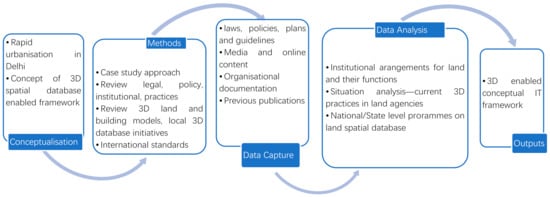
Figure 1.
Methodology overview.
The current legal and planning landscape related to land and property development has been studied in context of 3D aspects. The institutional arrangements have been studied considering the scope for the development of 3D data. The international works [,,], which are about the current practices related to 3D are used to provide information for this scope. The existing spatial data systems, models or programmes with 3D components are presented and reviewed for Delhi and Prague cities. The 3D spatial information components of the domain models and standards about land and buildings as Land Administration Domain Model (LADM) and BIM have been considered for technological assessment. The initiatives taken to create digital spatial database in Delhi and Prague are reviewed. The policy drivers provide argument to have 3D spatial database for the land agencies. The drivers’ arguments are based on technical, financial and planning aspects mainly. Further, a conceptual framework is proposed which shows the utilization of 3D spatial database enabled IT system for better land administration, planning, development and management functioning.
3. Current Practices and State of the Art
3.1. Current 3D Practices of Land Agencies in Delhi
The content on current 3D practices has been referenced for Delhi []. Van Oosterom’s research [] has been re-used to provide an analytical framework which examines usage of 3D information and its uptake within the land agencies. Table 1, taking the case of Delhi, shows that the processes of land acquisition and zonal level planning, performed at the initial stages, does not adopt 3D representation practice. The 2D and 3D graphic representations are generated and utilized during the design phase for the new spatial objects. Registration of spatial objects as individual units or condominiums textually mentions the usage purpose of basements or floor units, but 3D graphic representations are not practiced. Use permits do not consider 3D aspects and are given in text although bye-laws and permissions define 3D rights and restrictions in textual format. Data recorded under engineering surveys, using total stations, is currently stored and analysed in 2D. 3D positions are usually marked as annotations on 2D CAD (Computer Aided Design) drawings. Checks and validations are performed on the spatial unit data submitted, including third dimension mentioned in text format. Information dissemination about spatial units is usually in 2D but if required, then it is disseminated in 3D. In general, adoption of 3D representation practice in the case of Delhi land agencies, is used less in terms of graphics. These current practices show that designated land use rights in 3D for built-up properties are part of property registration process although these rights are not defined graphically. Checks and validation process is performed for the submitted layout plans where 3D is mentioned in text form, but rights associated with the spatial unit are not considered in 3D. Building bye-laws for Delhi textually mention restrictions in 3D as definitions provided for the height of each individual floor, shared walls, ceiling and floor among the individual units in a building. These definitions provide the legal extent of rights in 3D. Acquiring appropriate land or space through purchase or acquisition under the designated land acquisition law is not considered in 3D for a new property development or extension. So, the status of associated rights, restrictions and responsibilities are vague. Acquiring space in 3D is different from 3D surveying process which helps to demarcate the physical boundaries in 3D.

Table 1.
Current practices for 3D by land agencies in Delhi, India; Source: [].
3.2. Current 3D Practices of Land Agencies in Prague
Table 2, taking the case of Prague, shows that the process of planning, performed at the initial stages, does partially adopt 3D representation practice. The 3D graphic representations are generated and utilized during the design phase for the new spatial objects, typically high-rise buildings. Checks and validations are performed in 3D in the case of the new buildings. The building permits are considered with a height limit using the 3D model of Prague (more information about this 3D model is in Section 3.3). Data recorded under existing 2D digital cadastral map contains only the building outline and no spatial information about the apartments is displayed. 3D drawings are not part of 2D cadastral maps. Information dissemination about spatial units is usually in 2D, but Prague Institute of Planning and Development also disseminates in 3D. In general, adoption of 3D representation practice in the case of land agencies of Prague, is quite moderate in graphical form.
Table 2.
Current practices for 3D by land agencies in Prague, Czech Republic.
3.3. The 3D Model of Prague
Prague has a detailed digital 3D model of all its buildings, terrain and green spaces. The 3D model is an important resource when planning construction, height regulations and land use rulings []. The model was created using photogrammetric assessment of aerial photographs taken from 2000 to 2008. The most recent update of development data took place in 2016, and terrain data in 2018. The development model is accurate to at least 0.5 m, and the terrain model to at least 1 m. Currently, most of the Prague’s spatial data is stored in geodatabase. Regarding the 3D model of Prague, the data are stored in shapefiles. However, the intention is to update the storage and store the 3D model of Prague in spatial database based on 3DCityDB []. The initial transformation of 3D model of Prague into CityGML and its storage in 3DCityDB was explored in []. Figure 2 shows the digital technical map with 3D coordinates of features constituting a thematical map of surface situation (UMPS) and networks of technical infrastructure. The Figure 3 shows the 3D model of Prague and 3D networks of technical infrastructure.
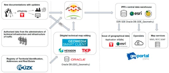
Figure 2.
Technological solution of digital technical map of Prague [].
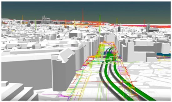
Figure 3.
The 3D model of Prague and 3D networks of technical infrastructure; Source: [].
3.4. Delhi Geospatial System for Land and Infrastructure
A project for “CREATION OF DELHI STATE SPATIAL DATA INFRASTRUCUTRE (DSSDI) FOR GNCTD” was initiated by Survey of India (SOI) as a 3D geographical information system (GIS) solution including generation of large-scale base map from the aerial photographs obtained in 2007 to cover the state of National Capital Territory of Delhi in an area of about 1500 sq kms. A public sector company “Geospatial Delhi Limited” (GSDL) has been created under DSSDI project, a Geo-Knowledge enterprise of Government of National Capital Territory of Delhi. GSDL offers a geoportal as a free centralized single window web application enabling standard access to the selected geoinformation to the public. It also includes land records of Delhi as 2D GIS dataset. It has GIS applications for city governance including forest, water board, education, health, municipal and development authority services, disaster management authority resources. The geospatial data creation for the land records of Delhi has been performed in a two-dimensional GIS environment, accessible through a GIS enabled portal as shown in Figure 4. The similar type of data is shared with Delhi Development Authority and Municipal Corporations as per their requirement [].
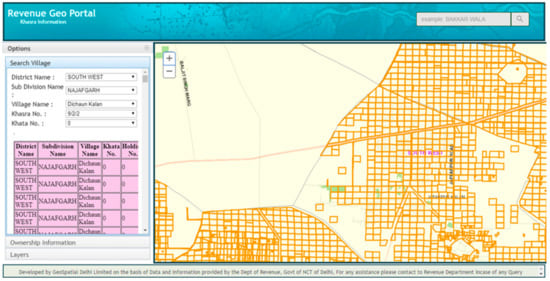
Figure 4.
Geographical information system (GIS) enabled portal for revenue purposes in Delhi; (Source: []).
Thus, current practices and existing data-based initiatives in GIS format for land, infrastructure and terrain can be justified under the “Smart City Mission” of India and a lot of redevelopment and relocating processes are happening. Backed by a 3D spatial database, these redevelopment and relocation processes can become sustainable with 3D representation [].
4. Vertical Growth and Legal, Planning and Organizational Provisions of the Two Cities
4.1. Vertical Growth in Delhi
With the growth of Delhi, land use change has happened substantially. Traditionally, Delhi has preserved its skyline, but the land use change in Delhi has resulted in the increase in infrastructural density and demand for different uses of land competes for the available space [,]. The competition is not limited only to horizontal but also to the vertical dimension. Delhi has now multi-storey and high-rise residential buildings in the entire city. The redevelopment is happening in some pockets of Delhi with multi-dimensional growth of infrastructure in the city. Urban extension areas planned under Master Plan of Delhi 2021 involve construction of high-rise buildings for residential purposes. In Delhi, 2D data is commonly used by land agencies. The policies regarding 3D land information are, in general, not present.
4.2. Vertical Growth in Prague
In Prague, it was decided to focus more on the further development of the city centre than to support the new constructions around the city and, therefore, less number of new high-rise buildings are coming up in Prague. However, Prague has a substantial number of existing multi-storey and high-rise buildings.
In Prague, in the case of a new construction, the 3D panoramic drawing has to be delivered. This drawing is done in digital form and has to use the existing 3D digital model of Prague. The created panoramic drawing is then submitted to the Prague Institute of Planning and Development for its evaluation.
4.3. Legal, Planning and Organizational Provisions
Legal basis is required for formulation and adoption of any policy change. Creation of a favourable policy for 3D spatial data capturing would require legal support. In Delhi, legal provisions exist regulating the land planning and development. The Registration Act 1908 of India, is the legal instrument controlling land tenure through registration of land or property. The property can be individual units in a multi-storey or high-rise building. The registry details include the 3D components description of the property unit. Master plan of Delhi (MPD2021) acts as the guiding framework to be followed for the land use planning. The different recommendations of the MPD2021 indicate the 3D information advantages as it emphasizes the vertical growth of space, promoting group housing for land optimization and enhancement of ground coverage. It also specifies height limits for all categories of residential plots. It provides for mixed land use to meet the demand for commercial space along with new parking policies including multi-level and underground parking. Redevelopment with higher density is recommended, and areas for tall buildings are to be identified in cases of urban extension []. The Real Estate Regulatory Authority Act 2016 (RERA) [] and Unified Building Bye-Laws (UBBL) [] for Delhi comprehensively provide definitions related to building, high rise buildings, building height, room height, floors, individual flat units, common spaces, basement, obligations of promoters, allottees and authorities. Moreover, UBBL, 2016 makes it mandatory that the section in a building plan must indicate the total height of buildings, rooms and the height of the parapet. Parapet is a low protective wall along the edge of a roof, bridge or balcony. Service plans for utility networks such as water, sewage and gas are to be shown. Details are to be shown for all elevations. This includes façades with total height of buildings, permissible projections beyond the permissible building line, location of doors, windows and other openings, including ventilators, with size in a textual schedule form. In fact, the RERA Act 2016 includes enclosed spaces in its definition of the self-contained part of an immovable property. This analysis strongly indicates the readiness of legal and policy provisions in Delhi for creating a 3D spatial database to be adopted by its land administration and land management systems. Beyond the State level UBBL and RERA, the National Building Code [] of India acts as the Pan-India guideline for building construction activities.
The different characteristics of these legal and planning provisions could collectively use a 3D spatial database with relevant attributes, geometrical and topological requirements. Table 3 summarizes the legal and planning provisions in Delhi and Prague pertaining to land and buildings with a description of linkages with 3D aspects.
Table 3.
Legal and planning aspects related to 3D in Delhi and Prague.
Land administration and land management involves an array of functions to be performed. The land agencies in India and Czech Republic along with the respective functions are shown in Table 4.
Table 4.
Functions of land administration and land management arrangements in India (Delhi) and Czech Republic (Prague).
4.4. Land Agencies in Delhi, India and Their Functions
The Land is a State subject in India and policy matters related to land and property in India are primarily handled by the States. Department of Land Resources (DoLR) of Ministry of Rural Development under Government of India, guide and facilitate States to modernize land record management and build up a land information system. The functions include matters related to land reforms, land tenure, land records and consolidation of holdings. The DoLR has a Digital India Land Records Modernization Programme (DILRMP). The DILRMP has three major components—(a) computerization of land record, (b) survey/re-survey and (c) computerization of registration. The digital land records are maintained in 2D format. It is not known the survey/re-survey includes any kind of 3D information such as terrain variations [].
The Ministry of Housing and Urban Affairs, Government of India [] as the national scale apex authority involves in formulating policies, sponsoring and supporting programme, coordinating the activities of various central ministries, state governments and other nodal authorities and monitoring the programmes concerning all the issues of housing and urban affairs in the country.
The surveying in India is performed by Survey of India on behalf of Government of India. In addition to infrastructure, natural features above the surface, it surveys the terrain elevation variation information as contours. The contours contain the elevation height information for 3D mapping. There are also private licensed surveyors in India using latest surveying equipment with laser or GPS-based technologies. These technologies can record the surroundings as well as the terrain in the form of three-dimensional information.
The registration of land or property in the city of Delhi is performed by Registrar Office, Department of Revenue, Government of Delhi []. The registry is also performed for the multi-storey properties and individual flat units. Planning and Development function for city of Delhi is primarily performed by Delhi Development Authority promoting vertical development in urban extensions []. Management of different types of land and property management is primarily the responsibility of Municipal Corporation of Delhi (MCD) for most part of the city. After the de-notification of an area by DDA, MCD takes control of building activities and applies provisions of the Municipal Corporation Acts for the land and infrastructure management. The slums (referred to as “JJ Clusters” in Delhi) are mostly under the mandate of the Delhi Urban Shelter Improvement Board (DUSIB) [], and some of them are managed by DDA. Many of the slums have multi-storey structures. The DUSIB and DDA organizes slum residents into resettlement colonies and will soon be provided individual housing units into multi-storey buildings.
Digital land and infrastructure records for Delhi city are created and maintained by a public sector company under Government of Delhi known as “Geospatial Delhi Limited, Government of Delhi”. The digital records for multi-storey and high-rise buildings are maintained in a GIS environment with “Height” stored as an attribute. GIS files are maintained for utility networks with information about the height and depth they are located at.
4.5. Land Agencies in Prague, Czech Republic and Their Functions
In the case of Czech Republic, Czech Office for Surveying, mapping and cadastre is responsible for land and property related policy matters. The existing digital land records are maintained in 2D format. The National Set of Spatial Objects (NSSO) Programme of Czech Republic is defined as the source of guaranteed and reference geographic data at the highest possible level of detail for selected objects of the real world, covering the whole territory of the Czech Republic []. The data is going to be created as 3D.
The Czech Republic has a Czech Office for Surveying, Mapping and Cadastre, Land Survey Office as well as private licensed surveyors. A crucial role in measuring a terrain in surveying, and mapping applications play the geodetic point fields. Due to the rapid development in the domain of information technologies, it makes sense to consider using the 3D spatial database to manage the information about the geodetic point fields including trigonometric and densification points (horizontal point field), the levelling points (vertical point field) and gravity point (gravitational point field). Janečka [] proposed the creation of a 3D spatial database which integrates the information about the various kinds of established geodetic point fields with the aim of enabling their effective management. To enable analyses of 3D terrain situation, the Land Survey Office further produced the Digital Terrain Model 5th generation for the whole Czech Republic. Considering the NSSO programme, the methodologies and policies describing the surveying of objects in 3D have to be created. Currently, the survey information, especially from the private licensed surveyors, includes also the Z (height) information. However, this is not used for cadastral nor planning information.
The authority responsible for the registration of land and property (including multi-storey properties and individual flat units) in Prague and also in the whole Czech Republic, is the Czech Office for Surveying, Mapping and Cadastre. In Prague, city planning and development is performed by the Prague Institute of Planning and Development.
In the case of Prague, the Prague Institute of Planning and Development performs Planning and Development function for city. In the Prague city, creation of digital land and infrastructure records is executed by the Prague Institute of Planning and Development, which is arranging the current basic geographical data for all urban governance activities. The Digital Map of Public Administration of Prague includes the Technical map (with 3D coordinates and containing also networks of technical infrastructure), orthophoto maps, 3D model of Prague and a basic map of Prague at a scale of 1:25,000. The 3D model application of Prague, which is available to both experts and general public, provides a wide range of detailed information about every building, e.g., a number of floors and the owner.
5. Policy Drivers for 3D Spatial Database-Based IT Framework
With this background, the specific policy drivers are revealed for the creation of 3D spatial database enabled IT framework for land administration and land management activities.
First, Architects and engineers usually try to find ways to save design cost of property unit under development. They require more certainty in efficiency of designing process to make it robust, reliable and cost worthy. In Delhi and Prague cities, architects and engineers have gradually adopted BIM as part of the building development process. BIM allows handling of 3D aspects of a building design. A 3D spatial database getting inputs and providing query-based outputs would enable geometrical and topological consistency check of floors in a building layout submitted as per the rules in the case of multi-storey or high-rise buildings. This can help in 3D capturing, storage, visualization and analysis of boundaries, volumes and spaces to enhance construction engineering works accuracy whether they are new developments, repair and regular maintenance by development authorities and municipal corporations.
Second, the development of high-rise buildings and complex structures increase the risk of construction errors and resource inefficiency. A proper 3D spatial database with attributes, geometric and topological characteristics of building components, provides opportunities for more efficient planning and designing of infrastructure. Planning could be performed using the data for individual floors and the inter-connectors which could help to avoid costly mistakes while doing construction as part of land development. Delhi and Prague both have witnessed the continued growth of high-rise buildings for residential and commercial purposes as well as complex structures with mixed land use providing commercial and office space. The complexities of design, common space division and interconnecting space require a 3D data management approach to bring efficiency during the development for efficient space usage, navigation network development, vertical and horizontal connectivity and timely and appropriate response for resource requirement on different stages of development. Land agencies in Delhi and Prague can utilize this information in 3D for further developments and learn to use resources more efficiently.
Third, the data interoperability is important for coordination among the land agencies. A 3D spatial database enabled IT framework representing land and building components and compatible with international standards of land, building or infrastructure will enable land administration and management officials to maintain records in a synchronized and holistic manner. Multiple agencies are involved in land administration and land management in Delhi and Prague. The agencies are not only connected on the local level but also have vertical linkages with national level agencies. However, a good level of coordination is required for the proper functioning of land agencies. This is only possible when the information flow between the agencies on local and national level happens in a smooth manner. Considering the vertical developments in Delhi and Prague, it is necessary to have similar data standards followed by the agencies in 3D also. These data standards will allow interoperability to fetch 3D data also for the ownership and leasehold rights for registration, validation and monitoring.
Fourth, 3D spatial database representing land and building components will allow clear demarcation of 3D spaces and claims over separate holdings in high-rises and multi-stories. Thus, legal and physical spaces can be earmarked and defined in 3D. This can be beneficial to any city like Delhi and Prague as 3D demarcations of space can avoid social conflicts due to property disputes. Often such disputes arise from different perceptions of boundaries. Clear demarcation in 3D can remove the vagueness about the boundaries in 3D.
Fifth, vertical growth of infrastructure in dense urban areas, generate physical space. The large complexes with physical spaces under common and exclusive ownerships can generate substantial revenue with financial transactions in the form of sale-purchase, rental and property taxation activities. 3D spatial database with various attributes capturing physical and legal aspects of land and building components bring clarity in tenure claims for both exclusive and common areas. This increases accuracy and certainty in the tax collections and property transfers or leasehold agreements. Delhi and Prague, both are the capital cities of their respective countries. Like any other metro city providing economic leverages, these cities attract high prices for space based on the high demand. Higher demand for space brings increased frequency of property transactions. Higher prices of space attract higher rates of taxes. These activities in metro cities like Delhi and Prague generate need for increased accuracy in the boundary’s determination and certainty in tenure claims. A 3D spatial database can help in achieving the desired level of accuracy by considering volume spaces and relevant attributes of the properties. This generates potential for more revenue.
Sixth, the insurance premiums and property valuations depend on the accuracy of physical space measurements, extents of legal space, type of material, exclusive and common facilities available, etc. This becomes important in the case of housing societies with common rights and responsibilities. The property insurers and economic valuators can benefit in performing the respective assessments or valuations, from the attributes and geometries stored in a 3D spatial database capturing various aspects of an individual unit physical and legal space. The space comes at a premium price in much sought locations of Delhi and Prague. The higher valuation of a property could directly affect the premium for property insurance. Delhi and Prague could have many such properties which use valuation services to generate mortgage against those properties. Similarly, high-rise and multi-storeys have individual properties which must be insured at a relevantly high level of premium. The role of 3D spatial database could be influential in getting more credit against the mortgaged property because of higher level of accuracy of space volume for the property [,]. The 3D spatial database can also raise the premium for higher volume of space. The data in 3D could provide significant evidence in hands of valuators and property insurers for decision making.
Seventh, land administration and management agencies are in general concerned with land related aspects of disaster management. 3D spatial database can help in land aspects of disaster management with creation and maintenance of 3D aspects of cadastre for verification of land tenure to settle claims for ownership and compensation and 3D visualization and simulation of land-based response and recovery planning. Informal and squatter settlements in Delhi may have the problem of overlapping claims with each party claiming the ownership of the property unit especially the common shared areas. Considering the high-rise buildings for residential purposes in Prague, the Civil Code considers the building unit as a separate piece of real estate and does not constitute a part of the land []. There is descriptive information about the owner of each building unit in the information system of cadastre of real estates, but no 3D graphical information describing the corresponding 3D spatial unit (building unit) is available. The ownership verification for compensation can be performed with more confidence using a 3D cadastre. The 3D spatial database can deal with the data storage, retrieval and editing requirements of a 3D cadastre.
Finally, 3D visualization using 3D spatial database in the backend could be used for promoting online participatory planning practices by land agencies. Metro cities like Delhi and Prague have to be transformed as smart cities to meet the demands of its residents in the future. A part of Delhi is already selected under “Smart City Mission” of India and a lot of redevelopment and relocating processes are happening. Backed by a 3D spatial database, these redevelopment and relocation processes can become sustainable with a participatory planning initiative. In the case of Prague, a 3D planning practice also starts to incorporate the 3D outputs from the BIM, especially the 3D models of the buildings (see the Figure 5). Using 3D visualization to display a digital twin of the city, online participatory planning could be a successful and fruitful exercise.
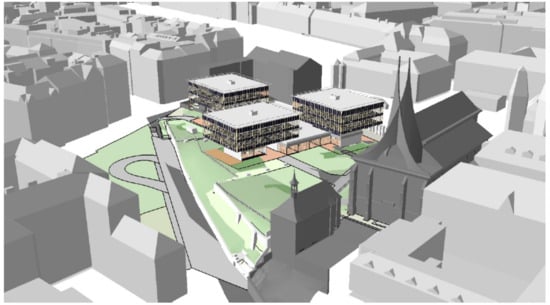
Figure 5.
The combination of building information management (BIM) (the buildings in the middle) and GIS (the buildings from the 3Dmodel of Prague) [].
6. 3D Spatial Database Enabled IT Framework for Land Agencies
The above qualitative analysis of current practices and data systems in Delhi and Prague, the policy drivers, legal, planning and organizational provisions reveals that cities in the two different type of economies are having vertical growth, but the land administration and management agencies yet have to fully understand and exploit the resources for creating and using a 3D spatial database enabled IT framework.
The described current practices for 3D adoption by land agencies reveal the gap which needs to be filled up beyond planning and designing. The lack of proper 3D information components, for land or property registry, building permits, dissemination, etc., provides the opportunity space.
Before moving forward to develop a framework, A review of international tools and standards for land, infrastructure and spatial data is presented. This sub-section describes the potential for upscaling or downscaling of database for 3D components in acceptable standards. This revelation can be generalized for cities in other countries with similar traits as rapid urbanization, vertical growth of infrastructure in cities, developing or developed economy, presence of digital spatial initiatives of land agencies and existing legal and planning provisions to support 3D concept.
6.1. International Tools and Standards for Land and Infrastructure and Other Spatial Data
Land and infrastructure domain has combinedly gained interest in recent years resulting in the development of tools and standards as LADM, CityGML, BIM, LandInfra, IndoorGML. One of the reasons behind this interest could be the growing urbanization leading to the vertical growth. The land agencies need to capture this vertical growth properly for the purposes of tenure security, taxation, valuation, insurance premiums, etc. A 3D spatial database enriched with the attributes and geometrical and topological consistencies in cohesion with these standards can be useful for the land agencies. Cities like Delhi and Prague with vertical growth can benefit from such a database.
The LADM, ISO 19,152 as a conceptual model includes elements above and below the surface of the earth. It provides for 3D aspects as spatial units in the form of “Apartment Units” and space defined in 3D []. These concepts can be used by the cities like Delhi and Prague to define the rights, restrictions and responsibilities for individual apartments and commonly owned undivided shared space and facilities in multi-storey and high-rise buildings. The concepts can be the foundation for further development of relevant laws and policies. The need to translate the 3D concepts of LADM in a 3D data modelling component, can be fulfilled by using CityGML, an open standard data model and exchange format data standard. CityGML can be used by the land administration and management agencies for digitally storing city level infrastructure and landscapes []. This model includes descriptions of feature in a city, such as buildings, roads, their relationships in different levels of detail as required by planners, designers, modelers and developers. The model could enable storage of the specific 3D relationships between objects such as an underground Delhi metro station, connecting to its surface level vehicle parking. The rich repository of different road furniture and building details can help to capture the building and other infrastructure models in detail, including 3D aspects in a standard manner. Thus, cities can have an internationally accepted standard format of infrastructure landscape in their digital twins. LandInfra is a model, using concepts from LADM, focused on division of land not only based on administrative jurisdictions, but also the property units as built-up infrastructure. It also defines the individual units in a building as “condominium units” and details out the various components. This model can act as an intermediate-model, with physical and legal elements it provide for information modelling [].
Once the city landscape is captured as different features on the desired level of detail, a 3D information model for individual buildings can be detailed using the Building Information Management. BIM is a relatively new concept to modern building development and management requirements [,]. BIM is a standard approach now for modern buildings in the cities but still needs to be used on a mass scale for buildings with multi-storeys and multi-owners of individual units. The inside information of a building can be extended from the indoor models like IndoorGML model which can detail out the multi-layered space as indoor-outdoor connection [].
OracleSpatial and PostGIS are the database models which can be used to design and structure a 3D spatial database as per data modelling rules. They provide several 3D spatial functions as 3D spatial indexing, 3D visualization, 3D data queries and topology checks. These 3D spatial functions could be useful for designing an IT framework for decision making. To gain from the combined advantages of different standards for specific applications, some researches have shown the possibility of integration. For example, IndoorGML and LADM integration can provide more accurate geometries for strata (in LADM) and also to be able to provide constraints (from RRR) for access of spaces and thus, enrich IndoorGML (which largely supports navigation) [,].
6.2. The Conceptual Framework
According to International Federation of Surveyors (FIG) [], there seems to be no problem for most of the buildings, even complex, in the case of aboveground objects, if 3D information is available (3D models, height information, descriptive 3D data, etc.) but in metro cities with underground utility networks such as different modes of transport, water, sewage, electricity and parking, the problem arise in defining, establishing, registering and managing stratified real property for integration. This fact can be true in the case of modern metro cities where vertical layers of infrastructure require integration due to their interconnectivity and interdependency.
A 3D spatial database, comprehensively addressing the gaps while learning from the relevant international tools and standards created with specific objectives, can help to support an information technology framework for land and infrastructure planning, development and management in urban areas.
The current functions of land agencies in a modern city, as shown in Figure 6, include land planning, surveying, development, tenure administration, management and monitoring and digitalized records. These functions are performed on existing features or to generate new features. Proposed activities with 3D aspects show that how 3D capabilities can be used for performing the relevant functions on the features in a digital spatial environment. Planning of cities or settlements may require 3D visualization and simulations. Surveying of topographic features, existing infrastructure and 3D land parcels is to be performed to capture data on terrain elevation and existing infrastructure measurements. Design and construction of infrastructure for the development of new built-up properties can be performed easily, rapidly and more accurately with 3D spatial designs. 3D registration of property including 3D aspects of built-up properties and 3D land parcels is executed as part of land tenure administration. Management and monitoring is required for approvals of vertical and horizontal building extensions, encroachments checks in 3D land parcels, repairs of building and utility infrastructure and tenure records updating. The functions also include creation and maintenance of digitalized records for spatial boundaries demarcation, text and numeric attributes data attachment, 3D queries and analysis of built-up property and 3D land parcels. Relevant tools and standards with 3D aspects can help to standardize the approaches to perform functions in a digital spatial environment. For example, 3D design and construction can be standardized using BIM while CityGML level of details (LoDs) can be used as a 3D data standard for building visualization on different scales. LADM concepts of 3D spatial unit and RRRs can be used for standardizing the details to be entered for 3D property registration.
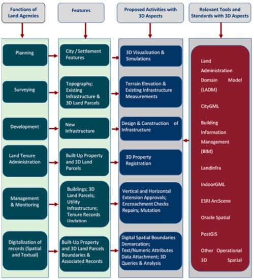
Figure 6.
The proposed activities with 3D aspects for a land administration system in a modern city.
Figure 7 shows an overview of information technology framework for 3D land planning and development requirements. It has three main components which are presented in a sequential order to understand the flow of the process. The first component on proposed activities with 3D aspects involves the 3D aspects of basic level to visualize a dataset with Z heights but also the surveying, designing, registration, mutation and analysis of the property. The second component on technical capabilities required to handle activities with 3D aspects also vary accordingly. Some of them are meant for visualization of 3D data only while others are focused on handling the geometrical and topological aspects of the 3D data. 3D data storage, animation, indexing, processing and query syntax are other aspects mentioned as well.
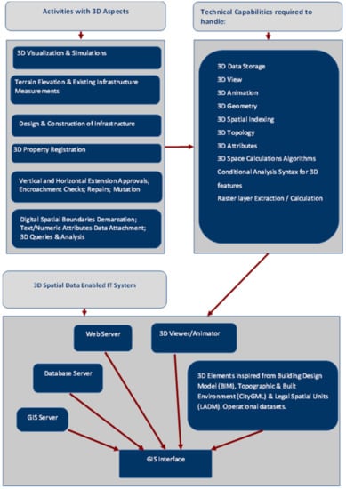
Figure 7.
Overview of information technology framework for 3D land planning and development requirements.
The final component of 3D spatial database enabled IT system can have server-based technologies (database, web, GIS) along with 3D viewer and 3D animator to perform the desired functions. A 3D spatial database could provide support for 3D data storage, 3D view, 3D animation, 3D geometry, 3D spatial indexing, 3D topology, 3D attributes, 3D space calculation algorithms and conditional analysis syntax for 3D features and raster layer extraction/calculation. A 3D spatial database enabled geospatial system, as part of a larger IT framework, could use these functionalities as a kind of spatial decision support system (SDSS) for land agencies. A knowledge-based element of this component involves 3D elements inspired from Building Design Model (BIM), Topographic and Built Environment (CityGML) and Legal Spatial Units (LADM). This could be helpful in providing essential tools for supporting various activities with 3D aspects in a standardized way. The standard definitions accepted internationally will help to design the tools which can overcome the limitation found in one standard, by using the related definition in other standards. This will give flexibility to fulfil the functional requirements of various land and built-up properties.
The Figure 8 shows different modules which can be the function-based core of the 3D spatial data enabled IT system. These modules represent the core functions of land agencies as shown in Figure 8. The functions are generalized based on the understanding derived from the literature review and the organizational arrangement for case study cities of Delhi and Prague. These are the most common and prominent functions of land agencies which need to be performed for the strategic and operational management of land and built-up properties in the city. A digital platform in the form of 3D spatial data enabled IT system with interconnectivity between these modules will provide easy access and usage capability to different land agencies for the execution of various responsibilities as 3D visualization for participatory planning, 3D scenario generation and simulations for understanding the potential future development alternatives and 3D survey data spatial indexing for quick retrieval of data against a 3D query. Considering the role of data in each module and also that the IT framework is mainly about information handling, it is decided to have a dedicated database management module, which can handle 3D spatial as well as non-spatial data. It could be the efficient data storage, optimum utilization of space and processing capacity for data retrieval through a query, data indexing including 3D spatial data indexing.
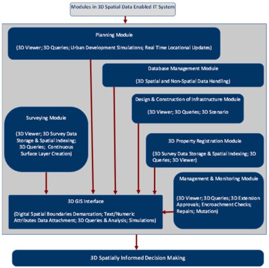
Figure 8.
Proposed 3D enabled modules of IT framework for spatially informed decision making.
7. Discussion
Vertical growth of cities such as Delhi and Prague create a complex infrastructure environment which requires 3D information to be generated and analysed for urban land planning, development and management agencies. The current practices of using 3D information by land agencies in Prague and Delhi cities are to a limited or moderate extent. However, the city of Prague and the city of Delhi both have the existing dedicated programme or public sector organization with 3D spatial information of city level. This includes buildings, terrain and other infrastructure. The 3D model is an important resource when planning construction, height regulations and land use rulings (refer to Figure 3 and Figure 4). It is important to understand that the two cities are the capital cities of their respective countries, so it is natural to receive migrants from other cities for the purpose of settling there. However, the land administration and management arrangements could be considered inspired from two different origins. While Delhi, or India as a whole, land system is adopted and influenced from the British colonial setup, the land system in Czech Republic is influenced from its communist history which disregarded the individual ownership of land. India is based in Asia, where most of the countries remained under colonial rules for almost half decades of the previous centuries. The urbanism spread quite late once India adopted liberalized economy to open its market for international players. Czech Republic in Europe has seen, very closely, the destruction of political systems and economy setups due to World War II and the communist era that followed. The end of communist regime changed the land system also towards more individual land ownerships. It has also got benefitted from the formation of European Union and being a part of it.
Policy drivers for creation and use of 3D spatial database for land agencies provide the favourable arguments for efficient visualization, designing and construction with higher accuracy, compatibility with 3D components of international information standards on land and infrastructure, higher accuracy in assessment of insurance premiums and property valuations, easy verification of land tenure to settle claims for ownership and compensation and promoting online participatory planning practices. Laws, rules and plans in Delhi and Prague are inclusive of 3D aspects related to definition of building components, buildings, mixed land use and registration of 3D space ownership. Multiple organizations are involved in creating land and housing related policies, create development plans, survey the areas, registration of properties and management as well as monitoring of developed properties. These functions have 3D aspects which can be efficiently dealt with by using 3D spatial database enabled IT framework. The existing international information standards and operational databases with 3D capabilities of land agencies could provide an approach where a 3D enabled framework will be a comprehensive solution for most of the land agencies functions. The proposed framework can make a difference providing interconnectivity, ease of access and usage, time and cost efficiency, enhanced organizational coordination and spatial data information-based decision-making process. A higher level of activity, quality with minimization of human errors, transparency as part of e-governance will be profitable in social and economic terms both for the country.
8. Conclusions
The rapid urbanization leading to vertical growth is a challenge faced by the land agencies due to the new ways of urban settlements. The land planning, development and monitoring require new approaches in alignment with the advancements in informational technology and geospatial technologies. 3D spatial data enable IT framework is proposed for the various functions of land agencies as 3D land tenure registration to monitoring of properties in multi-storey and high-rise buildings. It is recommended to have specialized modules under this framework supported with spatial technologies for digitally executing various functions of the land agencies. A 3D spatially enabled IT framework will help in enhanced transparency in governance, administration and management related to land and property matters with increased participation of the stakeholders including the community. The adoption of this framework can prepare the land agencies for their futuristic role when there will be increased demand for 3D related aspects of land and property is expected. The dedicated modules for the core functions with the capability to handle 3D spatial can increase the specialization or skills of the employees. This can save the time and operating cost which can help to serve more people by the land agencies. The transparency of the decision-making system can be enhanced with such framework for the community due to a visual interface providing access to the input processes and outputs used by the land agencies to reach a planning, development and monitoring decision. It can also help to involve people through participation in simulation exercises for new development plans to reach a consensus together. The planning and further implementation will be more sustainable due to this practice. Standard procedures can be established with enhanced technical accuracy, social acceptance and commercial feasibility. On the other hand, updating the skills and the datasets to handle the 3D aspects could be a challenging task. Human resources need to be trained for handling the increased complexity of the data handling processes and to interpret correctly the meaning of 3D processing outputs. The training can be a costly affair for an agency. The cost to transform the mostly available 2D datasets into 3D datasets could also be challenging financially and needs to be checked for its commercial feasibility. The process of enhanced community participation could have a sustainable impact on the decisions implemented but they could also delay the process of decision making for developmental plans. This can defer the development process required for upgrading a city or a settlement. It can also substantially increase the financial cost.
Author Contributions
T.G. conceptualized and wrote an outline of the entire article and is the first author of Section 1, Section 2, Section 3, Section 4 and Section 5. K.J. is a co-author for Section 1, Section 2, Section 3, Section 4 and Section 5. S.Z. provided expert guidance for the entire article. All authors have read and agreed to the published version of the manuscript.
Funding
This research received no external funding.
Institutional Review Board Statement
Not Applicable.
Informed Consent Statement
Not Applicable.
Data Availability Statement
Data sharing not applicable.
Acknowledgments
This paper was supported by the project Sustainability support of the centre NTIS—New Technologies for the Information Society (LO1506) of the Czech Ministry of Education, Youth and Sports. The authors acknowledge Swinburne University for its continuous support and fruitful discussions related to this research.
Conflicts of Interest
The authors declare no conflict of interest.
References
- Nduwayezu, G.; Sliuzas, R.; Kuffer, M. Modelling urban growth in Kigali city Rwanda. Rwanda J. 2016, 1, 1. [Google Scholar]
- World Bank Group. Ghana’s Successful Urbanization, Chapter 1. Rising through Cities in Ghana: Ghana Urbanization Review Overview Report; World Bank: Washington, DC, USA, 2015; Available online: https://openknowledge.worldbank.org/handle/10986/22020 (accessed on 17 October 2020)License: CC BY 3.0 IGO.
- Ramachandra, T.V.; Sellers, J.; Bharath, H.A.; Setturu, B. Micro level analyses of environmentally disastrous urbanization in Bangalore. Environ. Monit. Assess. 2019, 191, 787. [Google Scholar] [CrossRef] [PubMed]
- CEIC (2019) 2000–2019, Yearly %, Zhenjiang Municipal Bureau of Statistics China CN: Population: Usual Residence: Urbanization Rate. Available online: https://www.ceicdata.com/en/china/population-prefecture-level-city-urbanization-rate/cn-population-usual-residence-urbanization-rate-jiangsu-zhenjiang (accessed on 7 November 2020).
- Zambon, I.; Colantoni, A.; Salvati, L. Horizontal vs Vertical Growth: Understanding Latent Patterns of Urban Expansion in Large Metropolitan Regions. Sci. Total Environ. 2018, 778–785. [Google Scholar] [CrossRef] [PubMed]
- Dasym. The Rise (and Descent) of the Vertical City. 2018. Available online: https://www.dasym.com/the-rise-and-descent-of-the-vertical-city/ (accessed on 17 February 2020).
- Billen, R.; Cutting-Decelle, A.-F.; Marina, O.; de Almeida, J.-P.; Caglioni, M.; Falquet, G.; Leduc, T.; Métral, C.; Moreau, G.; Perret, J.; et al. 3D City Models and Urban Information: Current Issues and Perspectives; European COST Action TU0801; EDP Science: Ulis, France, 2014; p. 117. [Google Scholar]
- Atazadeh, B.; Kalantari, M.; Rajabifard, A.; Champion, T.; Ho, S. Harnessing BIM for 3D Digital Management of Stratified Ownership Rights in Buildings (7968), FIG Working Week. 2016. Available online: https://fig.net/resources/proceedings/fig_proceedings/fig2016/papers/ts03c/TS03C_atazadeh_kalantari_et_al_7968.pdf (accessed on 5 August 2020).
- Unger, E.M. 1.2 Defining the Research Problem, Introduction, Chapter 1, Responsible Land Administration in Disaster Risk Management, Approaches for Modelling, Integrated Governance and Policy Transfer of People, Land and Disasters. Ph.D. Thesis, University of Twente, Enschede, The Netherlands, 2019; pp. 4–5. [Google Scholar]
- Paulsson, J. 3D Property Rights—An Analysis of Key Factors Based on International Experience. Ph.D. Thesis, Royal Institute of Technology (KTH), Stockholm, Sweden, 2007. [Google Scholar]
- New America, Why 3D Cadastres Are Important for Property Rights; 3D Cadastre and Property Rights. Available online: https://www.newamerica.org/future-property-rights/reports/proprightstech-primers/3d-cadastre-and-property-rights (accessed on 5 October 2020).
- Emamgholian, S.; Taleai, M.; Shojaei, D. Exploring the applications of 3D proximity analysis in a 3D digital cadastre. Geo-spatial Inf. Sci. 2020, 1–14. [Google Scholar] [CrossRef]
- Ghawana, T.; Sargent, J.; Bennett, R.; Zevenbergen, J.; Khandelwal, P.; Rahman, S. 3D Cadastres in India: Examining the status and potential for land administration and management in Delhi. In Land Use Policy; Elsevier: Amsterdam, The Netherlands, 2020; p. 98. [Google Scholar] [CrossRef]
- Breunig, M.; Zlatanova, S. 3D geo-database research: Retrospective and future directions. Comput. Geosci. 2011, 37, 791–803. [Google Scholar] [CrossRef]
- Atazadeh, B.; Kalantari, M.; Rajabifard, A.; Ho, S.; Ngo, T. Building Information Modelling for High-rise Land Administration. Trans. GIS 2017, 21, 91–113. [Google Scholar] [CrossRef]
- Kumar, K.; Labetski, A.; Ohori, K.A.; Ledoux, H.; Stoter, J. The LandInfra standard and its role in solving the BIM-GIS quagmire. In Open Geospatial Data, Software and Standards; Springer: Berlin/Heidelberg, Germany, 2019; p. 1. Available online: https://opengeospatialdata.springeropen.com/articles/10.1186/s40965-019-0065-z#citeas (accessed on 5 January 2021).
- World Bank. GDP Per Capita (Current US$). 2021. Available online: https://data.worldbank.org/indicator/NY.GDP.PCAP.CD (accessed on 5 January 2021).
- World Bank. Overview, the World Bank in India. 2020. Available online: https://www.worldbank.org/en/country/india/overview (accessed on 5 January 2021).
- OECD. Overview, OECD Economic Surveys: Czech Republic© OECD 2020. 2020. Available online: https://www.oecd-ilibrary.org/economics/oecd-economic-surveys-czech-republic-2020_1b180a5a-en (accessed on 5 January 2021).
- Van Oosterom, P. Research and development in 3D cadastres, Computers. In Environment and Urban; Elsevier: Amsterdam, The Netherlands, 2013. [Google Scholar]
- Van Oosterom, P.; Lemmen, C.; Thompson, R.; Janecka, K.; Zlatanova, S. 3D Cadastres Best Practices, Chapter 3: 3D Cadastral Information Modelling. In Proceedings of the FIG Working Week, Istanbul, Turkey, 10–14 May 2018; p. 42. [Google Scholar]
- Janecka, K.S.; Karki, P.; Van Oosterom, P.S.; Zlatanova, M.; Kalantari, T. Ghawana, 3D Cadastres Best Practices, Chapter 4: 3D Spatial DBMS for 3D Cadastres. In Proceedings of the FIG Working Week, Istanbul, Turkey, 10–14 May 2018; p. 59. [Google Scholar]
- Prague Building Regulations. 2015. Available online: http://en.iprpraha.cz/uploads/assets/en/PDF%20uploads/PraugeBuilidingRegulations_english_1.pdf (accessed on 5 October 2020).
- 3DCityDB. Available online: https://www.3dcitydb.org/3dcitydb/ (accessed on 10 November 2020).
- Janečka, K. Transformation of 3D Geospatial Data into CityGML—A Case of Prague. 2019. Available online: https://content.sciendo.com/view/journals/rgg/107/1/article-p41.xml?lang=en (accessed on 22 October 2020).
- Čtyroký, J. The digital technical map of Prague. In Proceedings of the Digital Technical Map Today and Tomorrow Conference, Prague, Czech Republic, 18 October 2019. (In Czech). [Google Scholar]
- GSDL, Delhi Public Geoportal, Geospatial Delhi Limited. Available online: https://gsdl.org.in/DelhiPublic.html (accessed on 22 November 2020).
- Henssen, J. Land Registration and Cadastre Systems: Principles and Related Issues, Lecture Notes, Masters Program in Land Management and Land Tenure; TU München: Munich, Germany, 2010. [Google Scholar]
- Jain, M.; Dimri, A.P.; Niyogi, D. Urban sprawl patterns and processes in Delhi from 1977 to 2014 based on remote sensing and spatial metrics approaches. Earth Interact. 2016, 20, 1–29. [Google Scholar] [CrossRef]
- Jain, M.; Dawa, D.; Mehta, R.; Dimri, A.P.; Pandit, M.K. Monitoring land use change and its drivers in Delhi, India using multi-temporal satellite data. Model. Earth Syst. Environ. 2016, 2, 19. [Google Scholar] [CrossRef]
- Delhi Master Plan. Delhi Development Authority. 2021. Available online: http://119.226.139.196/tendernotices_docs/aug120/01%20Master%20Plan%20for%20Delhi-%202021%20(updated%2031.12.2020)07012021.pdf (accessed on 29 January 2021).
- RERA. Real Estate (Regulation and Development) Act, India. 2016. Available online: https://www.indiacode.nic.in/handle/123456789/2158?locale=en (accessed on 6 July 2020).
- UBBL. Unified Building Bye-Laws for Delhi. 2016. Available online: https://upload.indiacode.nic.in/showfile?actid=AC_CEN_5_5_00028_195766_1517807321857&type=notification&filename=Notification%20Dt.%2017.06.2016%20reg.%20making%20of%20Unified%20Building%20Bye%20Laws%20for%20Delhi..pdf (accessed on 5 July 2020).
- NBC. National Building Code of India, Bureau of Indian Standards. 2016. Available online: https://bis.gov.in/?page_id=117159 (accessed on 10 October 2020).
- DoLR, Digital India Land Record Modernization Programme, Programme Details. Available online: https://dolr.gov.in/programme-schemes/dilrmp/digital-india-land-record-modernization-programme (accessed on 29 November 2019).
- Ministry of Housing and Urban Affairs, Mandate. Available online: http://mohua.gov.in/cms/mandate.php (accessed on 22 December 2019).
- Revenue Department of Delhi. Property Registration. 2020. Available online: http://revenue.delhi.gov.in/wps/wcm/connect/doit_revenue/Revenue/Home/Services/Property+Registration (accessed on 10 October 2020).
- DDA, Delhi Development Authority. Available online: http://www.dda.org.in/ (accessed on 10 February 2020).
- DUSIB, Delhi Urban Shelter Improvement Board. Available online: https://delhishelterboard.in/main/?page_id=8190 (accessed on 5 November 2020).
- Čada, V.; Janečka, K. The Strategy for the Development of the Infrastructure for Spatial Information in the Czech Republic. ISPRS Int. J. Geo-Inf. 2019, 5, 33. [Google Scholar] [CrossRef]
- Janečka, K. The Integrated Management of Information about the Geodetic Point Fields—A Case of the Czech Republic. Geosciences 2019, 9, 307. [Google Scholar] [CrossRef]
- Isikdag, U.; Horhammer, M.; Zlatanova, S.; Kathmann, R.; van Oosterom, P. Utilizing 3D Building and 3D Cadastre Geometries for Better Valuation of Existing Real Estate. In Proceedings of the FIG Working Week ‘From the Wisdom of Ages to the Challenges of Modern World’, Sofia, Bulgaria, 17–21 May 2015; pp. 1–18. [Google Scholar]
- Isikdag, U.; Horhammer, M.; Zlatanova, S.; Kathmann, R.; van Oosterom, P.J.M. Semantically rich 3D building and cadastral models for valuation. In Proceedings of the 4th International FIG 3D Cadastre Workshop, Dubai, UAE, 9–11 November 2014; pp. 35–53. [Google Scholar]
- Janečka, K.; Souček, P. A Country Profile of the Czech Republic Based on an LADM for the Development of a 3D Cadastre. ISPRS Int. J. Geo-Inf. 2017, 6, 143. [Google Scholar] [CrossRef]
- Čtyroký, J. BIM in Prague: Why and How? In Proceedings of the GIS Esri in the Czech Republic Conference, Prague, Czech Republic, 10–12 June 2020. (In Czech). [Google Scholar]
- LADM. Geographic Information—Land Administration Domain Model (LADM); ISO 19152:2012(E); ISO: Geneve, Switzerland, 2012. [Google Scholar]
- CITYGML. 2018. Available online: https://www.citygml.org/about/ (accessed on 28 November 2019).
- LandInfra. OGC® Land and Infrastructure Conceptual Model Standard. 2016. Available online: https://www.ogc.org/standards/landinfra (accessed on 15 October 2020).
- BIM-ISO19650. Organization and Digitization of Information about Buildings and Civil Engineering Works, Including Building Information Modelling (BIM)—Information Management Using Building Information Modelling; ISO 19650-1:2018. 2019. Available online: https://www.iso.org/obp/ui/#iso:std:68078:en (accessed on 22 November 2019).
- Buildingsmart, BIM Collaboration Format (BCF)—An Introduction. 2019. Available online: https://technical.buildingsmart.org/standards/bcf/ (accessed on 1 November 2020).
- IndoorGML, OGC. Available online: http://www.indoorgml.net/ (accessed on 1 November 2020).
- Alattas, A.; van Oosterom, P.; Zlatanova, S.; Diakité, A.; Yan, J. Developing a database for the LADM-IndoorGML model. In Proceedings of the 6th International FIG 3D Cadastre Workshop, Delft, The Netherlands, 2–4 October 2018; pp. 259–276. [Google Scholar]
- Alattas, A.; Zlatanova, S.; van Oosterom, P.; Li, K.-J. Improved and More Complete Conceptual Model for the Revision of IndoorGML. In Proceedings of the 10th International Conference on Geographic Information Science (GIScience 2018), Dagstuhl, Germany, 28–31 August 2018; p. 21. [Google Scholar] [CrossRef]
- Kitsakis, D.; Paasch, J.M.; Paulsson, J.; Navratil, G.; Vučić, N.; Karabin, M.; El-Makawy, M.; Koeva, M.; Janečka, K.; Erba, D.; et al. Existing 3D objects, Chapter 1, Legal foundations. In Best Practises 3D Cadastres—Extended Version; van Oosterom, P., Ed.; FIG: Copenhagen, Denmark, 2018; pp. 1–66. ISBN 978-87-92853-64-6. [Google Scholar]
Publisher’s Note: MDPI stays neutral with regard to jurisdictional claims in published maps and institutional affiliations. |
© 2021 by the authors. Licensee MDPI, Basel, Switzerland. This article is an open access article distributed under the terms and conditions of the Creative Commons Attribution (CC BY) license (http://creativecommons.org/licenses/by/4.0/).