Land Use Evaluation over the Jema Watershed, in the Upper Blue Nile River Basin, Northwestern Highlands of Ethiopia

 ,
,
Abstract
1. Introduction
2. Materials and Methods
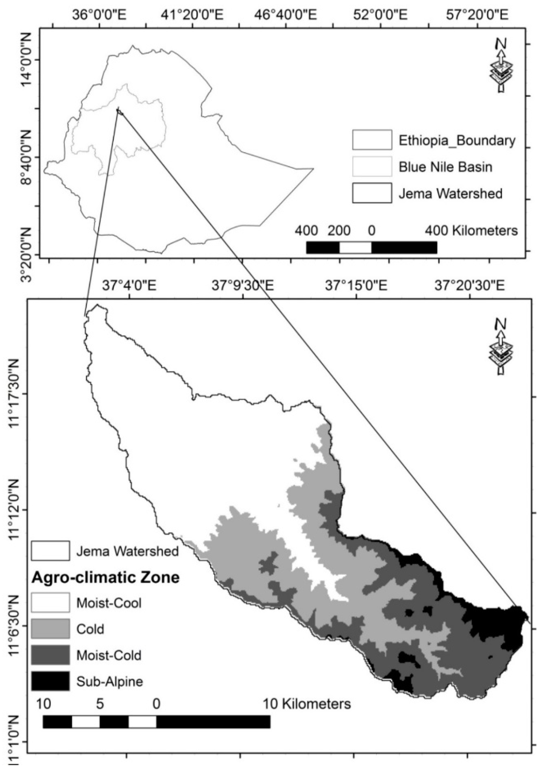
2.1. Description of the Study Site
2.2. Analysis of Land Capability Class (LCC)
2.2.1. Spatial Variability of ATRF
2.2.2. Spatial Variability of Soil Texture
2.2.3. Producing LCC Layer
2.3. Spatial Variability of Land-Use Land Cover
3. Results and Discussion
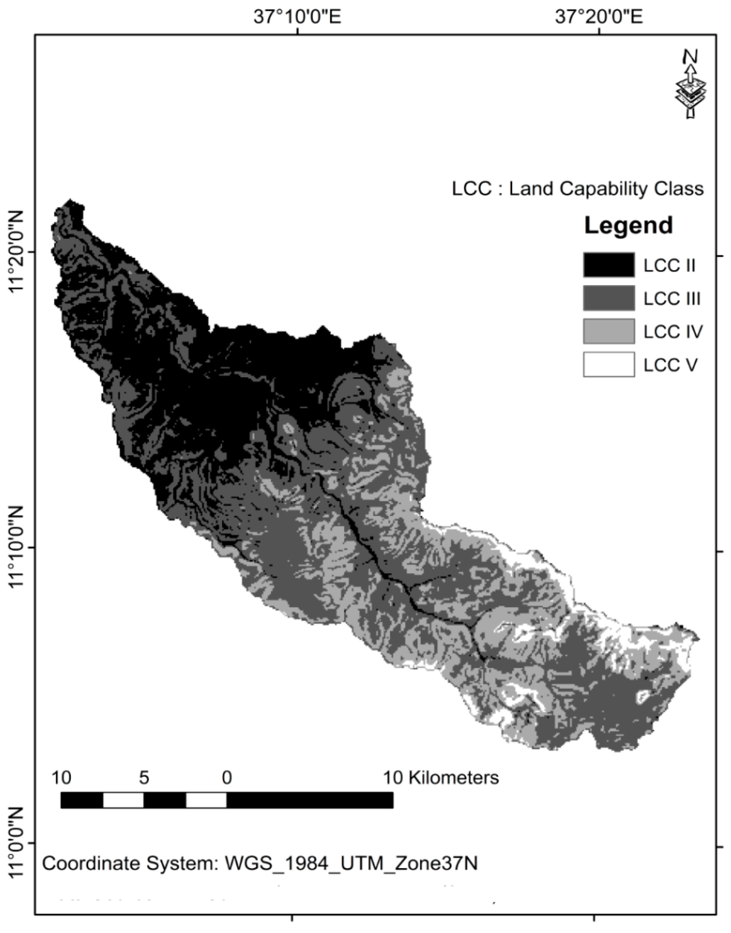
3.1. Spatial Pattern of Land Capability Class
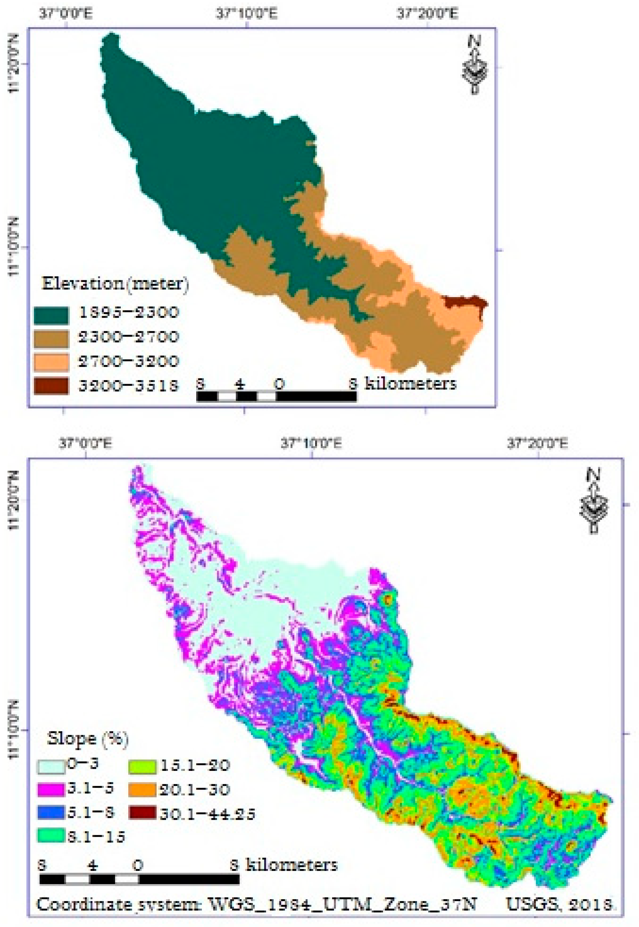
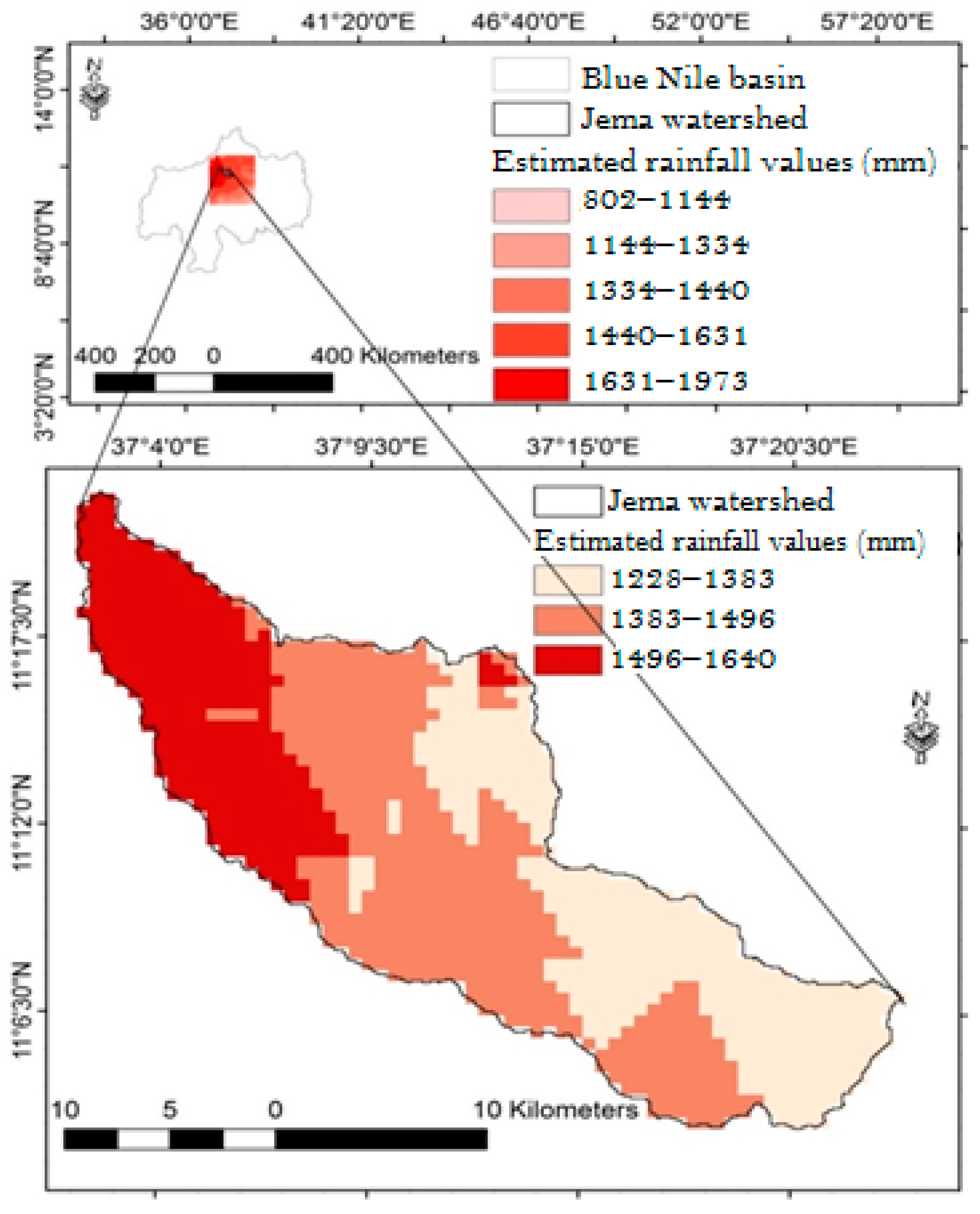
3.1.1. Surfacing the Spatial Distribution of the ATRF
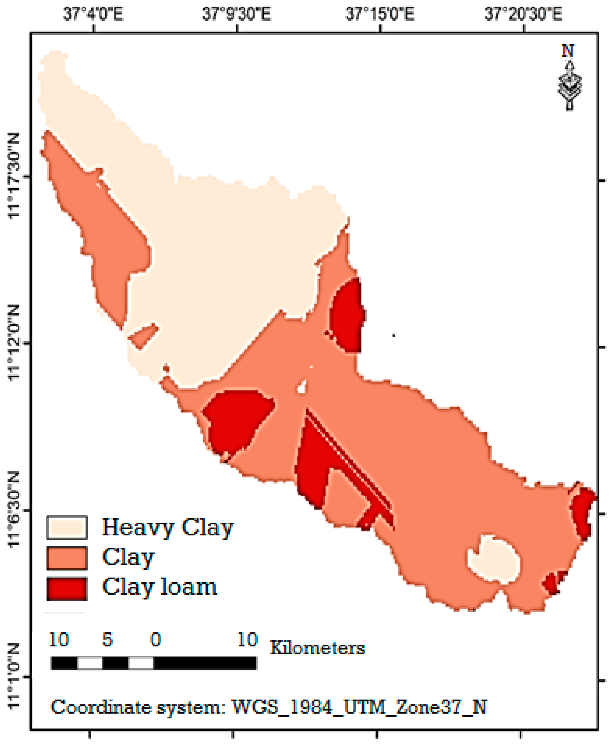
3.1.2. Geo-Statistical Interpolation of Soil Texture
3.1.3. Land Capability Class
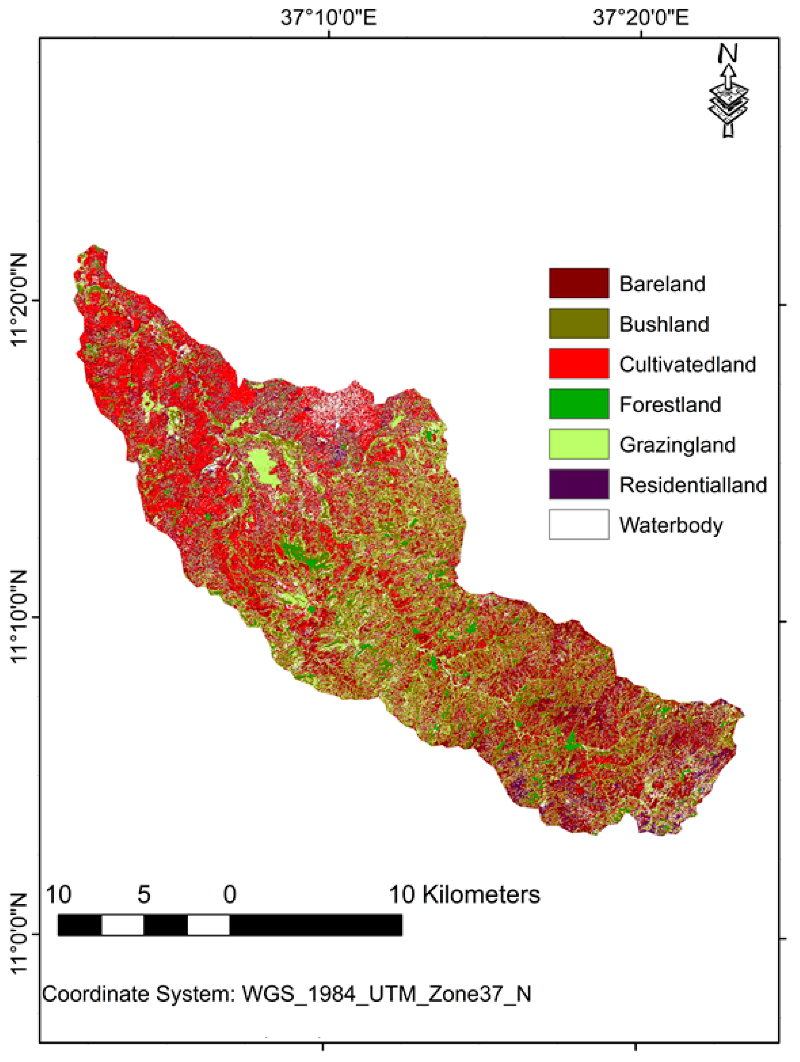
3.2. Spatial Variability of Land-Use Land Cover
3.3. Cultivated Land Use versus Arable Land Capability Class
4. Conclusions and Recommendations
Author Contributions
Funding
Acknowledgments
Conflicts of Interest
References
- Ministry of Finance and Economic Development (MOFED). Ethiopia’s Climate-Resilient Green Economy, Green Economy Strategy; Federal Democratic Republic of Ethiopia: Addis Ababa, Ethiopia, 2011.
- Central Statistics Agency (CSA). Summary and Statistical Report of the 2007 Population and Housing Census Results; UNFPA: Addis Ababa, Ethiopia, 2008; p. 83. [Google Scholar]
- Simane, B.; Zaitchik, B.F.; Foltz, J.D. Agroecosystem specific climate vulnerability analysis: Application of the livelihood vulnerability index to a tropical highland region. Mitig. Adapt. Strateg. Glob. Chang. 2014, 21, 39–65. [Google Scholar] [CrossRef] [PubMed]
- Zaitchik, B.F.; Simane, B.; Habib, S.; Anderson, M.C.; Ozdogan, M.; Foltz, J.D. Building climate resilience in the Blue Nile/Abay Highlands: A role for earth system sciences. Int. J. Environ. Res. Public Health 2012, 9, 435–461. [Google Scholar] [CrossRef] [PubMed]
- Berhanu, B.; Melesse, A.M.; Seleshi, Y. GIS-based hydrological zones and soil geo-data base of Ethiopia. Catena 2013, 104, 21–31. [Google Scholar] [CrossRef]
- Mengistu, D.; Bewket, W.; Lal, R. Recent spatiotemporal temperature and rainfall variability and trends over the Upper Blue Nile River Basin, Ethiopia. Int. J. Climatol. 2014, 34, 2278–2292. [Google Scholar] [CrossRef]
- Central Statistics Authority (CSA). The World Bank. Ethiopia Rural Socioeconomic Survey (ERSS); CSA: Addis Ababa, Ethiopia, 2013.
- Genet, A.; Sebhat, M. Rainfall, Runoff and Soil loss, relationship on different land uses in the Upper Lake Tana Basin. J. Agric. Environ. Int. Dev. 2018, 112, 3–23. [Google Scholar]
- Luo, P.; He, B.; Duan, W.; Takara, K.; Nover, D. Impact assessment of rainfall scenarios and land-use change on hydrologic response using synthetic Area IDF curves. J. Flood Risk Manag. 2018, 11, S84–S97. [Google Scholar] [CrossRef]
- Ministry of Agriculture and Rural Development (MOARD). Agroecological Zonation of Ethiopia; MOARD: Addis Ababa, Ethiopia, 2000.
- Food and Agriculture Organization (FAO). Land Evaluation towards a Revised Framework; Land and Water Discussion Paper; FAO: Rome, Italy, 2007; Volume 6. [Google Scholar]
- Zeleke, G.; Hurni, H. Implications of land use and land cover dynamics for mountain resource degradation in the Northwestern Ethiopian Highlands. Mount. Res. Dev. 2001, 21, 184–191. [Google Scholar] [CrossRef]
- Landon, J.R. Booker Tropical Soil Manual: A Handbook for Soil Survey and Agricultural Land Evaluation in the Tropics and Subtropics; Routledge: Abington, UK, 2014. [Google Scholar]
- Tegene, B. Combining land capability evaluation, geographic information systems, and indigenous technologies for soil conservation in northern Ethiopia. East. Afr. Soc. Sci. Res. Rev. 2003, 19, 23–53. [Google Scholar] [CrossRef]
- Luo, P.; He, B.; Takara, K.; Xiong, Y.E.; Nover, D.; Duan, W.; Fukushi, K. Historical assessment of Chinese and Japanese flood management policies and implications for managing future floods. Environ. Sci. Policy 2015, 48, 265–277. [Google Scholar] [CrossRef]
- Anonymous. Amhara National Regional State Environmental Protection, Land Administration and Use Authority (ANRSEPLAA); The Revised Rural Land Administration and Use Determination Proclamation, No. 133/200; FAO: Addis Ababa, Ethiopia, 2006; pp. 11–70. [Google Scholar]
- Brath, A.; Montanari, A.; Moretti, G. Assessing the effect on flood frequency of land use change via hydrological simulation (with uncertainty). J. Hydrol. 2006, 324, 141–153. [Google Scholar] [CrossRef]
- Wang, G.; Zhang, Y.; Liu, G.; Chen, L. Impact of land-use change on hydrological processes in the Maying River basin, China. Sci. China Ser. D Earth Sci. 2006, 49, 1098–1110. [Google Scholar] [CrossRef]
- Van Dijk, A.I.; Beck, H.E.; Crosbie, R.S.; de Jeu, R.A.; Liu, Y.Y.; Podger, G.M.; Timbal, B.; Viney, N.R. The Millennium Drought in southeast Australia (2001–2009): Natural and human causes and implications for water resources, ecosystems, economy, and society. Water Resources Research 2013, 49, 1040–1057. [Google Scholar] [CrossRef]
- Hurni, H.; Tato, K.; Zeleke, G. The implications of changes in population, land use, and land management for surface runoff in the upper Nile basin area of Ethiopia. Mount. Res. Dev. 2005, 25, 147–154. [Google Scholar] [CrossRef]
- Taye, M.; Simane, B.; Selsssie, Y.; Zaitchik, B.; Setegn, S. Analysis of the Spatial Variability of Soil Texture in a Tropical Highland: The Case of the Jema Watershed, Northwestern Highlands of Ethiopia. Int. J. Environ. Res. Public Health 2018, 15, 1903. [Google Scholar] [CrossRef]
- Taye, M.; Simane, B.; Zaitchik, B.; Setegn, S.; Selassie, Y. Analysis of the Spatial Patterns of Rainfall across the Agro-Climatic Zones of Jema Watershed in the Northwestern Highlands of Ethiopia. Geosciences 2019, 9, 22. [Google Scholar] [CrossRef]
- Tessema, I.; Simane, B. Vulnerability analysis of smallholder farmers to climate variability and change: An agro-ecological system-based approach in the Fincha’a sub-basin of the upper Blue Nile Basin of Ethiopia. Ecol. Process. 2019, 8, 5. [Google Scholar] [CrossRef]
- Hurni, H. Degradation and conservation of the resources in the Ethiopian highlands. Mount. Res. Dev. 1988, 8, 123–130. [Google Scholar] [CrossRef]
- Teferi, E.; Bewket, W.; Uhlenbrook, S.; Wenninger, J. Understanding recent land use and land cover dynamics in the source region of the Upper Blue Nile, Ethiopia: Spatially explicit statistical modeling of systematic transitions. Agric. Ecosyst. Environ. 2013, 165, 98–117. [Google Scholar] [CrossRef]
- Setegn, S.G.; Srinivasan, R.; Dargahi, B.; Melesse, A.M. Spatial delineation of soil erosion vulnerability in the Lake Tana Basin, Ethiopia. Hydrol. Process. 2009, 23, 3738–3750. [Google Scholar] [CrossRef]
- Davidson, D.A. The Evaluation of Land Resources; Longman Scientific: London, UK, 1992. [Google Scholar]
- Klingebiel, A.A.; Montgomery, P.H. Land-Capability Classification. Agricultural Handbook, No. 210; Soil Conservation Service, US Department of Agriculture: Washington, DC, USA, 1961.
- Minale, A.S.; Rao, K.K. Impacts of land cover/use dynamics of Gilgel Abbay catchment of Lake Tana on climate variability, Northwestern Ethiopia. Appl. Geomat. 2012, 4, 155–162. [Google Scholar] [CrossRef]
- Amsalu, A.; de Graaff, J. Farmers’ views of soil erosion problems and their conservation knowledge at Beressa watershed, central highlands of Ethiopia. Agric. Hum. Values 2006, 23, 99–108. [Google Scholar] [CrossRef]
- Bewket, W. Towards Integrated Watershed Management in Highlands of Ethiopia: The Chemoga Watershed Case. Ph.D. Thesis, Wageningen University and Research Centre, Wageningen University Research, Wageningen, The Netherlands, 2003. [Google Scholar]
- Bewket, W.; Teferi, E. Assessment of soil erosion hazard and prioritization for treatment at the watershed level: Case study in the Chemoga watershed, Blue Nile basin, Ethiopia. Land Degrad. Dev. 2009, 20, 609–622. [Google Scholar] [CrossRef]
- Morgan, R.P.C. Soil Erosion and Conservation, 2nd ed.; Longman Group Unlimited: London, UK, 1995. [Google Scholar]
- Uhlenbrook, S. Biofuel and water cycle dynamics: What are the related challenges for hydrological processes research? Hydrol. Process. 2007, 21, 3647–3650. [Google Scholar] [CrossRef]
- Hansen, A.J.; DeFries, R.S.; Turner, W. Land Use Change and Biodiversity: A Synthesis of Rates and Conse-quences during the Period of Satellite Imagery Land Change Science; Gutman, G., Janetos, A.C., Justice, C.O., Moran, E.F., Mustard, J.F., Rindfuss, R.R., Skole, D.L., Turner, B.L., Cochrane, M.A., Eds.; Springer: Dordrecht, The Netherlands, 2004; pp. 277–299. [Google Scholar]
- DeFries, R.; Bounoua, L. Consequences of land use change for ecosystem services: A future unlike the past. GeoJournal 2004, 61, 345–351. [Google Scholar] [CrossRef]
- Pongratz, J.; Reick, C.H.; Raddatz, T.; Claussen, M. Effects of anthropogenic land cover change on the carbon cycle of the last millennium. Glob. Biogeochem. Cycles 2009, 23, 1–13. [Google Scholar] [CrossRef]
- Poppe, L.; Frankl, A.; Poesen, J.; Admasu, T.; Dessie, M.; Adgo, E.; Deckers, J.; Nyssen, J. Geomorphology of the Lake Tana basin, Ethiopia. J. Maps 2013, 9, 431–437. [Google Scholar] [CrossRef]
- National Meteorological Agency (NMA). Initial National Communication of Ethiopia to the United Nations Framework Convention on Climate Change (UNFCCC); NMA: Addis Ababa, Ethiopia, 2007.
- Food and Agricultural Organization (FAO); ISSS Illinois. World Reference Base for Soil Resources; World Soil Resources Reports 84; FAO: Rome, Italy, 1998. [Google Scholar]
- Bureau of Finance and Economic Development (BOFED). Population Affaires Core Process Based on 2012 Inter-Censal Survey; Amhara National Regional State Development Indicator 2014/15; Amhara National Regional State: Bair Dar, Ethiopia, 2014.
- Young, A. Tropical Soils and Soil Survey; Cambridge Geographical Studies 9; Paperback Edition; Cambridge University Press: Cambridge, UK, 1976. [Google Scholar]
- Environmental Systems Research Institute (ESRI). ArcGIS Desktop: Release 10.2.2; Environmental Systems Research Institute: Redlands, CA, USA, 2014. [Google Scholar]
- Mohammad, Z.M.; Taghizadeh-Mehrjardi, R.; Akbarzadeh, A. Evaluation of geostatistical techniques for mapping spatial distribution of soil pH, salinity and plant cover affected by environmental factors in Southern Iran. Notulae Sci. Biol. 2010, 2, 92–103. [Google Scholar]
- Robinson, T.P.; Metternicht, G. Testing the performance of spatial interpolation techniques for mapping soil properties. Comput. Electron. Agric. 2006, 50, 97–108. [Google Scholar] [CrossRef]
- International Soil Reference and Information Centre (ISRIC). Procedures for Soil Analysis. Technical Paper, 6th ed.; ISRIC: Wageningen, The Netherlands, 2002; ISBN 90-6672-044-1. [Google Scholar]
- Asmare, B.; Mekuriaw, Y.; Tekliye, L. Evaluation of desho grass (Pennisetum pedicellatum Trin.) morphology, yield and chemical composition under irrigation in northwestern Ethiopia. J. Agric. Environ. Int. Dev. 2018, 112, 241–252. [Google Scholar]
- Bartholomé, E.; Belward, A.S. GLC2000: A new approach to global land cover mapping from Earth observation data. Int. J. Remote Sens. 2005, 26, 1959–1977. [Google Scholar] [CrossRef]
- Lillesand, T.; Kiefer, R.W.; Chipman, J. Remote Sensing and Image Interpretation; John Wiley & Sons: Hoboken, NJ, USA, 2014. [Google Scholar]
- Monserud, R.A. Methods for Comparing Global Vegetation Maps; International Institute for Applied Systems Analysis: Laxenburg, Austria, 1990. [Google Scholar]
- Conway, D. The climate and hydrology of the Upper Blue Nile River. Geogr. J. 2000, 166, 49–62. [Google Scholar] [CrossRef]
- Webster, R. Soil Science and Geostatistics. Soil Geography and Geostatistics-Concepts and Applications; European Commission, Joint Research Centre, Institute for Environment and Sustainability: Copenhagen, Denmark, 2008; pp. 1–11. [Google Scholar]
- Bockheim, J.G.; Gennadiyev, A.N.; Hammer, R.D.; Tandarich, J.P. Historical development of key concepts in pedology. Geoderma 2005, 124, 23–36. [Google Scholar] [CrossRef]
- Ahmed, A.S.; Kebede, F.; Haile, M. Land Capability Classification and growing period for Guila Abena Watershed in Sassie Tseda Emba District in Eastern Tigray, Ethiopia. Nat. Sci. 2010, 8, 237–243. [Google Scholar]
- Setegn, S.G.; Rayner, D.; Melesse, A.M.; Dargahi, B.; Srinivasan, R. Impact of climate change on the hydroclimatology of Lake Tana Basin, Ethiopia. Water Resourc. Res. 2011, 47. [Google Scholar] [CrossRef]


| Categories/Profiles for Slope (%), Soil Texture (%), Mean Annual Total Rainfall (mm) and Elevation (m a.s.l) | LCCs and Their Degree of Limitation | |||||
|---|---|---|---|---|---|---|
| I (0) | II (0.2) | III (0.4) | IV (0.6) | V (0.8) | VI (1) | |
| Flat or almost flat (0–3) | x | |||||
| Gently sloping (3–8) | x | |||||
| Sloping (8–10%) | x | |||||
| Moderately steep (10–15) | x | |||||
| Steep (15–30) | x | |||||
| Very steep (30–44.25) | x | |||||
| Heavy clay | x | |||||
| Clay | x | |||||
| Clay loam | x | |||||
| Wet (>1400 mm) | x | |||||
| Moist (900–1400 mm) | x | |||||
| Moist–cool (1895–2300) | x | |||||
| Cold (2300–2700) | x | |||||
| Moist–cold (2700–3200) | x | |||||
| Sub-Alpine (3200–3518) | x | |||||
| Path and Raw Number of the Scene: | Path: 170, and Raw: 52 |
|---|---|
| Number of bands (spectral resolution) | Out of 9 multispectral and 1 panchromatic band, red–green–blue (RGB), i.e., 4, 3 & 2 band combinations was used |
| Ground pixel size (spatial resolution) | Thirty meter resolution multispectral bands |
| Sensor name | Landsat 8 |
| Product name | L1T |
| Cloud cover (%) | 0.05 |
| Reflectance bias | −0.100000 |
| AEZ | Elevation (m) | ATRF (mm) | MTmax (°C) | MTmin (°C) |
|---|---|---|---|---|
| Moist–Cool | 1895–2300 | 1497–1640 | 26.5 | 10.3 |
| Cold | 2301–2700 | 1381–1496 | 25.3 | 9.9 |
| Moist–Cold | 2701–3200 | 1311–1380 | 23.1 | 7.5 |
| Sub-Alpine | 3201–3518 | 1228–1310 | 21.0 | 4.7 |
| Texture Class | Area Coverage (km2) | Area Coverage (%) |
|---|---|---|
| Heavy clay | 184.940 | 38.217 |
| Clay | 254.402 | 52.572 |
| Clay loam | 44.571 | 9.211 |
| Total | 483.915 | 100 |
| LCC | Area Coverage (ha) | Area Coverage (%) |
|---|---|---|
| II | 13,778.71 | 28.56 |
| III | 22,067.29 | 45.74 |
| IV | 10,690.41 | 22.16 |
| V | 1707.72 | 3.54 |
| Total | 48,244.12 | 100 |
| LCC | Area Coverage (%) in Each of the ACZ | |||
|---|---|---|---|---|
| Moist–Cold (1895–2300 m a.s.l) | Cold (2301–2700 m a.s.l) | Moist–Cool (2701–3200 m a.s.l) | Sub-Alpine (3201–3518 m a.s.l) | |
| II | 47.92 | 0.00 | 0.56 | 1.75 |
| III | 43.75 | 59.07 | 16.00 | 12.82 |
| IV | 8.34 | 40.93 | 46.66 | 52.62 |
| V | 0.00 | 0.00 | 36.78 | 32.82 |
| True Class | ||||||||||
|---|---|---|---|---|---|---|---|---|---|---|
| 1 | 2 | 3 | 4 | 5 | 6 | 7 | Total | User’s Accuracy (%) | ||
| Predicted Class | 1 | 17 | 0 | 3 | 0 | 0 | 2 | 0 | 22 | 77.27 |
| 2 | 0 | 14 | 0 | 1 | 1 | 0 | 0 | 16 | 87.50 | |
| 3 | 2 | 0 | 23 | 0 | 0 | 0 | 1 | 26 | 88.46 | |
| 4 | 0 | 1 | 0 | 19 | 0 | 0 | 0 | 20 | 95.00 | |
| 5 | 1 | 0 | 0 | 0 | 12 | 0 | 0 | 13 | 92.31 | |
| 6 | 0 | 0 | 0 | 0 | 0 | 11 | 2 | 13 | 84.62 | |
| 7 | 0 | 0 | 0 | 1 | 0 | 3 | 10 | 14 | 71.43 | |
| Total | 20 | 15 | 26 | 21 | 13 | 16 | 13 | OAA = 85.48 (%) | ||
| Producer’s Accuracy (%) | 85.00 | 93.33 | 88.46 | 90.48 | 92.31 | 68.75 | 76.92 | |||
| LULC Types | Area Coverage and Proportion in the ACZs | |||||||
|---|---|---|---|---|---|---|---|---|
| Moist–Cool Highland | Cold | Moist–Cold | Sub-Alpine | |||||
| Area (ha) | % | Area (ha) | % | Area (ha) | % | Area (ha) | % | |
| Bare land | 1915.61 | 6.67 | 1357.99 | 9.14 | 687.38 | 16.00 | 38.03 | 8.28 |
| Bush land | 2307.80 | 8.04 | 1659.96 | 11.17 | 292.32 | 6.81 | 59.00 | 12.85 |
| Cultivated land | 12,230.10 | 42.61 | 3768.01 | 25.35 | 1266.35 | 29.48 | 91.22 | 19.87 |
| Forested land | 367.83 | 1.28 | 473.00 | 3.18 | 139.39 | 3.25 | 6.39 | 1.39 |
| Grazing land | 11,071.44 | 38.57 | 7270.90 | 48.93 | 1737.34 | 40.45 | 249.01 | 54.25 |
| Settlement land | 758.12 | 2.64 | 305.82 | 2.06 | 169.18 | 3.94 | 14.67 | 3.20 |
| Water bodies | 50.69 | 0.18 | 25.58 | 0.17 | 3.40 | 0.08 | 0.68 | 0.15 |
| Total | 28,701.59 | 100 | 14,861.25 | 100 | 4295.34 | 100 | 458.98 | 100 |
© 2019 by the authors. Licensee MDPI, Basel, Switzerland. This article is an open access article distributed under the terms and conditions of the Creative Commons Attribution (CC BY) license (http://creativecommons.org/licenses/by/4.0/).
Share and Cite
Taye, M.; Simane, B.; F. Zaitchik, B.; G. Selassie, Y.; Setegn, S. Land Use Evaluation over the Jema Watershed, in the Upper Blue Nile River Basin, Northwestern Highlands of Ethiopia. Land 2019, 8, 50. https://doi.org/10.3390/land8030050
Taye M, Simane B, F. Zaitchik B, G. Selassie Y, Setegn S. Land Use Evaluation over the Jema Watershed, in the Upper Blue Nile River Basin, Northwestern Highlands of Ethiopia. Land. 2019; 8(3):50. https://doi.org/10.3390/land8030050
Chicago/Turabian StyleTaye, Mintesinot, Belay Simane, Benjamin F. Zaitchik, Yihenew G. Selassie, and Shimelis Setegn. 2019. "Land Use Evaluation over the Jema Watershed, in the Upper Blue Nile River Basin, Northwestern Highlands of Ethiopia" Land 8, no. 3: 50. https://doi.org/10.3390/land8030050
APA StyleTaye, M., Simane, B., F. Zaitchik, B., G. Selassie, Y., & Setegn, S. (2019). Land Use Evaluation over the Jema Watershed, in the Upper Blue Nile River Basin, Northwestern Highlands of Ethiopia. Land, 8(3), 50. https://doi.org/10.3390/land8030050