Abstract
This study examines the entire urban network of Hungary, excluding Budapest, with the primary goal of creating a nationwide cadastre that systematically documents the country’s stock of urban squares found in cities. As traditional elements of the urban fabric, squares typically serve as focal points within a city’s spatial structure, reflecting the maturity of its urban form and embodying its socio-cultural heritage. Yet, in many towns, especially in central areas of cities, squares have not reached their full potential. Their development poses challenges in structural terms (form and spatial relationship with surrounding buildings), compositional terms (continuity of building frontages and design coherence), and functional terms (hierarchical role among public spaces). The absence of literature systematically compiling and analyzing Hungary’s urban squares is notable, given their significance as principal public spaces and indicators of urban life quality. This research addresses that gap by (1) identifying whether the town has a central square, (2) compiling an inventory of their number, (3) grouping 94 representative examples by morphological typology, and (4) selecting a stratified sub-sample of 55 for detailed morphometric and contextual analysis. The resulting typology provides a foundation for further morphological research and offers a reference for spatial planning and development policy.
Keywords:
urban squares; morphology; historical cities; spatial character; typology; spatial focus; cadastre 1. Introduction
The material presented in this study is part of a larger research project that aims to systematize and categorize the types of urban squares found in Hungary, identify their characteristics and frequency, and explore the urbanization patterns through the study of public squares. Due to the significant disparities within Hungary’s urban network, this study focuses exclusively on provincial (non-capital) cities. As Budapest’s population is approximately ten times larger than that of the largest regional cities, its inclusion in the analysis would result in a disproportionate distortion, hindering a balanced comparison. The objective of the selection process is to establish a catalog and registry, which can then be analyzed according to various criteria. This research draws upon international typological studies [1,2,3,4], as well as Hungarian literature on urban squares that have been published so far [5,6,7,8,9,10,11,12,13,14,15,16,17,18,19,20,21,22,23,24,25].
The scope and ambition of this research are immense. How can such a vast collection of urban squares be systematically organized and presented? Even determining which squares should be included in the selection poses a challenge, along with establishing the criteria for inclusion. The analysis was conducted through literature reviews, cartographic selections, and the compilation of student works. This study summarizes key knowledge and common characteristics that define public squares, specifically those found in Hungarian cities.
Recent research in Hungary has examined the various effects of suburbanization, including urban sprawl [26], the functional change of peri-urban areas [27,28], and the transformation of suburban areas in relation to city centers [29]. Elif Sarihan and Éva Lovra’s research focuses on the role of superimposed urban layers in shaping structures, with a particular emphasis on the relationship between streets, blocks, and buildings. However, their study does not encompass the investigation of urban squares [30].
Zhang et al. analyze urban morphology research articles according to six main categories of morphological indicators. However, this study does not specifically analyze squares, which are important elements of the urban fabric [31].
Neither the Hungarian nor the international literature examines urban squares with a focus disaggregated by individual regions or countries. No comprehensive reference exists that compiles the stock of urban squares within a given territory and analyzes their number, distribution, and characteristics. Yet urban squares are among the primary generators of urban life; their existence and functioning are essential for vibrant public space systems. Establishing a typology is equally important, as it allows researchers and practitioners to work with a manageable dataset and formulate shared development strategies based on common attributes.
To address this gap, the present study undertakes a nationwide investigation of nearly all legally recognized towns (249 of 348) in Hungary, excluding the capital and new towns produced in the last 30 years. The research first records whether each town contains a central urban square and counts the total number of squares per settlement, thereby creating a complete national inventory. From this dataset, a representative sample of 94 urban squares is selected for morphological classification. A second-stage selection reduces this to 55 squares, proportionally representing each morphological category, which are then examined in depth through quantitative morphometric analysis combined with historical, spatial, and functional interpretation. The scope is deliberately limited to the territory within Hungary’s current borders; although typological parallels may exist with neighboring areas due to the shared nineteenth-century historical context, more than a century of divergent development, combined with practical constraints in data availability and resources, makes the national framework a methodologically sound focus.
Following preventive research, we developed our own morphological typology using the spatial typologies of international and Hungarian references about urban squares, which is suitable for describing urban squares of Hungary. This takes into account the frequency with which the squares under study are distributed, how and when they were formed, and thus presents the most common types of squares and their characteristics in Hungarian cities. This paper presents a novel methodology for spatial analysis that leverages the capabilities of 3D modeling, integrating the morphological characteristics of “square walls” (spatial enclosure formed by building frontages) and spatial layout configurations, and introducing a new conceptual framework for spatial focus. The full research includes data sheets on the 55 squares mentioned above, but these are not included in this article due to space limitations.
2. Materials and Methods
The aim of this research was to create a unified cadastre of Hungarian urban squares by presenting the most representative types. The first step was, therefore, to review Hungarian literature dealing mainly with the morphology of our squares and cities.
A review of relevant Hungarian urban planning and historical literature reveals that there is no existing work that directly aligns with the objectives of this research. However, numerous sources address related themes either closely or more broadly, particularly in the areas of urban morphology, historical development, and architectural character.
2.1. Hungarian Literature Review in Thematic Groups
2.1.1. Historical and Geographical Works
These works explore Hungarian squares in a broader context. They are characterized by a perspective that is not solely urbanistic or square-focused, and they generally cover a wider range than just Hungarian territory.
The Hungarian Urban History Atlas series adopts a historical approach, presenting detailed analyses of urban transformations through historical maps, drawings, and photographs. To date, six volumes have been published, with an additional seven in preparation [6]. This scholarly work demonstrates the temporal development of the squares and has been utilized during the study in the historical investigation of spatial concepts.
Tibor Mendöl examines several foreign cities alongside a selection of Hungarian urban environments [7]. The work focuses on the morphological analysis of cities related to their geographical position. As the book is written in a broader context, sometimes on an international scale, the Hungarian perspective is negligible. This source proved useful to our research mainly in terms of typology and perspective, given its broader scope.
György Granasztói provides an extensive overview of the formation and historical evolution of medieval cities in Hungary [8].
There is still a lot of literature that examines only one period of Hungarian urban development, or where the analysis of the city is only descriptive [9,10,11,12].
In terms of spatial development, two major periods are significant in Hungarian urban history. The first is the medieval era, during which enclosed urban structures within city walls were established. Several sources identify this period as the genesis of Hungarian urbanism [14,15,25]. The second major phase occurred in the 19th century, characterized by the densification and urbanization of city centers [25]. During this time, many cities developed large, square-shaped central spaces, often replacing or radically transforming earlier medieval layouts. This period also saw the vertical and spatial densification of urban cores, frequently involving the demolition of blocks and the widening of streets to create new squares.
Few examples remain of Baroque and Renaissance square design, though notable instances can be found in Vác, Esztergom, Eger, and Győr, where grandiose Baroque squares still exist (e.g., Saint Stephen Square in Esztergom and the square in front of the Basilica in Vác).
Modern central squares emerged in newly developed cities such as Kazincbarcika (socialist realist style), Ózd, Ajka, Dunaújváros, and Salgótarján, though their quality varies significantly [32,33].
2.1.2. Analytical, Typological Literatures—With an Urban Planning Focus
In addition to these broader works, several sources address the topic from a more specific perspective, particularly in terms of architectural heritage and urban aesthetics.
The Cityscape—Monuments series systematically explores the urban characteristics of nine historic Hungarian cities: Szeged, Pécs, Veszprém, Pápa, Vác, Szentendre, Kecskemét, and Miskolc. While the series was intended to follow a unified methodology, stylistic differences emerge due to the varied authorship—some volumes contain extensive analytical drawings, while others prioritize textual descriptions and photographic documentation [13].
Nonetheless, this series has limitations. First, it covers only nine cities, despite the fact that many other Hungarian cities possess architecturally significant urban squares worthy of inclusion. Second, the collection is now somewhat outdated, as its volumes were published nearly sixty years ago, making their methodologies and findings less applicable to contemporary urban studies.
The urban planning perspective in historical city analysis is significantly enriched by the work of László Gerő, who extensively examines historical Hungarian cities. Three of his volumes address this topic: Hungarian Cityscape, Historical Urban Cores, and Historical Urban Districts [14,15,16]. While the latter two focus on the formation and preservation of historical urban cores, Hungarian Cityscapes attempts to define the unique characteristics of Hungarian urban landscapes and offers broader observations on the common features of Hungarian cities. This book stands out as one of the few works that explicitly evaluates the genetically Hungarian cityscape.
According to Gerő, the Hungarian city, in contrast to the rationally structured German cities and the picturesque nature of Italian cities [17,18], is characterized by a loosely arranged urban fabric, where alternating enclosed and open streetscapes integrate seamlessly with the surrounding landscape. Another key observation is that Hungarian cities densify gradually toward their urban core, with fully continuous row structures only appearing in the immediate city center, where buildings typically reach a maximum of one or two stories.
Additionally, Gerő highlights a distinctive Hungarian feature: even in densely built urban environments, Hungarian cities tend to have relatively wide streets, including in medieval urban layouts, whereas cities in other countries often exhibit much narrower cross-sections.
Gerő’s research primarily focuses on the evaluation of the cityscape, as well as the methods and possibilities for its preservation. His work provides a valuable foundation for studying the architectural and spatial structures of Hungarian cities. However, while his research extensively covers historical urban cores, there remains a need for a comprehensive typological analysis that systematically investigates the urban squares’ role, functions, and structural characteristics in city planning.
Similar conclusions about the Hungarian urban landscape are reached by Frigyes Pogány [19]. He discusses Hungarian urban planning alongside the broader context of European urban history, analyzing several Hungarian cities. Of particular importance to this research is that Pogány provides an analysis of certain urban squares that also appear in the present study. His approach to square analysis is based on visual perspectives and spatial perception.
A fundamental basis for studying urban square morphology and typology is provided by Tamás Meggyesi’s works [5,20,21]. His book Urban Planning Morphology presents a comprehensive summary of urban form, while Our Settlement Cultures focuses specifically on Hungarian urban squares, streets, and built environments. This latter study explores culturally Hungarian urban typologies, often rooted in rural and small-town contexts. However, this collection primarily highlights small-town and rural spatial typologies, meaning that large urban squares fall outside its scope.
2.1.3. The Literature of Modern Squares
Hungarian literature addresses modern urban spaces primarily in the context of reconstruction and transformation, with particular emphasis on the socialist period. These studies often focus on socialist realist spaces and city centers, examining construction history and processes of rebuilding. However, most of this literature does not employ a morphological approach, or does so only partially.
The examination of modern urban squares has been significantly enriched by various works. Notable among these is Kornélia Kissfazekas’s doctoral dissertation [22], which investigates the evolution of modern city cores, along with her related publications. Additionally, the works of Endre Prakfalvi and János Bonta’s book Hungarian Architecture Through the Eyes of a Contemporary provide essential insights into modern Hungarian urban architecture [23,24].
Despite these constraints, the existing literature provides essential context for understanding the historical development and structural characteristics of Hungarian cities. However, a comprehensive typological study of urban squares, particularly one aimed at systematizing and categorizing them, remains largely absent, highlighting the necessity and relevance of the present research.
The reviewed literature provides valuable context for understanding the development and structural characteristics of Hungarian cities. However, the typological approach to urban squares and the systematic study of public spaces remain largely unexplored.
The international literature, however, contains numerous examples of similar typological classifications, which have served as a foundation for the development of the methodological framework and analytical system employed in this research [34,35,36,37].
2.2. Subject of the Research: Initial Challenges in the Selection of Urban Squares
At the outset of the research, one of the most significant challenges was identifying which urban squares to include in the study. There is no comprehensive list or publication that systematically categorizes urban squares in Hungary. As the literature review indicates, several works address urban typology and morphology, but primarily from a historical perspective. Specific studies focusing on individual squares are typically limited to particular cities.
The aim of this research was not only to explore historically significant urban spaces but also to identify and analyze newly developed, modern squares. Furthermore, this study sought to ensure geographical representativeness by covering the entire territory of Hungary.
What we call a square in urban terms is defined on the basis of international literature. In urban studies, genuine urban squares usually refers to squares that serve classic, fundamental urban functions (meeting, commerce, and community events); are architecturally and spatially complete, typically well-defined and enclosed by buildings; are publicly accessible (open, publicly owned or managed, not private, or semi-public); are historically and socially embedded in the life of the city, rather than being modern, functionless plazas or purely transitional open spaces.
Criteria for identifying genuine urban squares (based on works by Rob Krier, Cliff Moughtin, Jan Gehl, and Carmona et al.) [1,3,38,39] include the following aspects:
- Location and Context
- ○
- Situated in a prominent or central part of the city.
- ○
- Connected to important streets or pedestrian networks.
- Spatial Definition
- ○
- Clearly enclosed or framed by continuous building fronts or other strong edges.
- ○
- Has a recognizable geometric form (rectangular, irregular, radial, etc.).
- Public Accessibility
- ○
- Fully open to the public without restrictions.
- ○
- Managed as a public space, not a privately controlled plaza.
- Functional Role
- ○
- Hosts diverse activities (markets, festivals, gatherings, and political events).
- ○
- Supports both everyday use (seating, transit, and leisure) and special events.
- Social and Cultural Significance
- ○
- Recognized as a meeting place and a symbolic site for the local community.
- ○
- Often historically important, with cultural or heritage value.
- Human Scale and Design Quality
- ○
- Walkable, with pedestrian-friendly proportions.
- ○
- Incorporates amenities such as seating, greenery, and shade.
In the international literature on the morphology of urban squares, they are defined as partially enclosed or fully closed spaces formed by walls, with an ideal space ratio of between 1:3 and 1:6, below which is more akin to street space. They are not perceived as open spaces, and above them, the viewer does not perceive walls; thus, they are declared much more as just open space [1,39,40,41,42]. The initial phase involved reviewing all 348 cities in Hungary, primarily using Google Maps. The focus was on identifying urbanistically defined squares—public spaces enclosed by built frontages.
In urban design terminology, the concept of a “closed street wall” is not formally defined. However, environmental psychology offers a relevant perspective through the principle of good continuation, which describes how humans tend to perceive aligned or uninterrupted elements as part of a unified whole. In the context of urban space, this perceptual tendency means that we experience a streetscape as “closed” when the built frontage maintains a coherent and continuous edge, without significant gaps or interruptions. This aligns with Gestalt theory, which posits that visual continuity strongly influences spatial perception [43,44].
Urban squares, according to their morphology, can be categorized in various ways, with each category representing an aesthetic quality of the square. Typification can be purely formal, in which case the most important aspect is the spatial layout of the area [3,4]. Others formulate categorizations according to how the squares are created, associating historicity with the way the squares are used in each particular form [5]. An important category is that of closed and open spaces. The literature evaluates the enclosure of corners and walls [2,4]. Another aspect of square classification is whether they are designed or oriented around a spatial element. This is the only category in which the spatial world takes into account not only the spatial layout but also the height of the surrounding walls [2,4].
Typological identification facilitates the management of squares, as similar spatial forms require similar approaches; their organization and use also tend to develop in similar ways. For this reason, it is the most appropriate form of classification; where this proved insufficient, we created special categories.
Urban character is closely linked to population density. Based on the analysis of Western Hungary, it was concluded that a population threshold of 10,000–15,000 inhabitants generally correlates with the presence of urban squares. This observation aligns with the fact that many of the newly designated cities since 1990 do not meet this population criterion, as even small and suburban “fast grown” settlements were granted city status during this period1 (Figure 1).
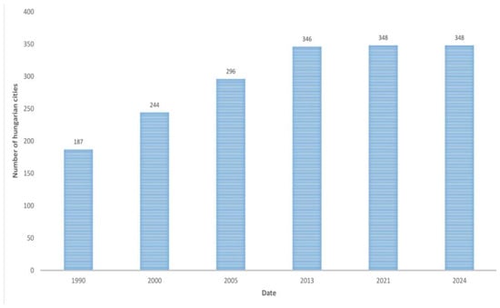
Figure 1.
Growth in the number of cities in Hungary, 1990–2024.
The examination of Eastern Hungarian cities was conducted using these two criteria: pre-1990 city status and a minimum population size. Nevertheless, exceptions exist—Kőszeg, for example, barely exceeds 10,000 inhabitants yet contains several notable squares. Similarly, many former market towns exhibit a high density of small public squares due to their clustered street networks and frequent intersections.
2.3. Methodology for Selecting a Representative Sample of Squares Across the Hungarian Urban Network
The reduced sample examined a total of 249 cities: in the area west of the Danube, the entire urban network was analyzed, while in the eastern part of the country, only cities with populations over 10,000 were included.
During the research, we first examined the city centers to identify where continuous street walls were present. We used data from Google Maps and Open Street Map for the collection. Within these areas, we then located squares that met the criteria of urban squares (see before)—that is, patterns predominantly defined by street walls that are used by the community. We excluded from the study those squares that lacked street walls or where the walls were not continuous and identifiable. Based on this, we distinguished two main types of urban squares: proto-squares and developed, well-formed squares. We also took into account the number of squares in each city and whether a coherent square structure exists.
From the squares of the 249 cities, approximately 94 squares were identified nationwide as a representative selection worthy of analysis and presentation. However, for the sake of manageability of detailed analysis, this number had to be reduced. To achieve this, morphological typologies were established based on the most characteristic spatial forms. The number of squares was then narrowed down to approximately 55, proportionally representing each type.
As of the current stage of the research, around 55 of these squares have undergone detailed analysis, including the creation of individual data sheets (Appendix A). The data sheets provide a comprehensive overview of the historical development and transformation of individual urban spaces, supported by historical maps, archival and contemporary photographs, and descriptive narratives. They include detailed information on spatial morphology and functional characteristics, such as size, spatial proportions, the ratio of paved to green areas, the degree of enclosure of the spatial edges, and the functions of bordering façades. The documentation also incorporates key graphical representations, including site plans, sections, and diagrams illustrating the integration of each space into the broader urban fabric. The examples are referenced in the sections of each typology as illustrative cases.
2.4. Spatial Foci and Focused Spaces—A New Approach to Urban Space Analysis
This study introduces a novel approach to the selection and analysis of urban spaces, narrowing the scope of examined spaces and proposing an individual methodology based on spatial focus. This analysis builds upon Rob Krier’s classification of spatial forms, which identifies the circle, square, and triangle as fundamental shapes, but expands it by incorporating Paul Zucker’s categorization principles, which emphasize the significance of enclosure and orientation in the grouping of squares. By integrating these two theoretical frameworks, the research developed an analytical approach that first determines the fundamental spatial geometry and its orientation, then defines the degree of enclosure or openness, as well as the prominence derived from variations in the height of the surrounding building facades [2,3].
While grounded in established spatial theories, this method offers a distinct perspective. Traditional spatial analyses have typically concentrated either on spatial form or on the enclosing façades; in contrast, this approach seeks to integrate both aspects under the concept of “spatial focus” (Figure 2).
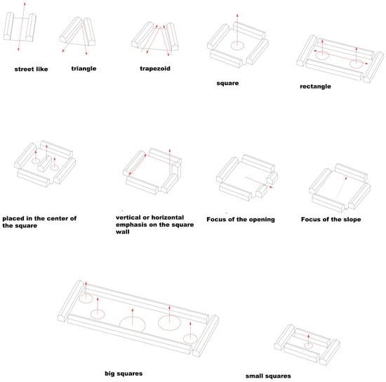
Figure 2.
Spatial focus analysis categories of primary and secondary focuses. Red circle: area defined by the spatial focus; Red arrow: direction of the spatial focus and subfocus.
The core idea of the spatial focus theory is that movement through urban space is always guided by a dominant direction or visual cue—every space is inherently focused. Accordingly, spaces can be classified as either single-focus or multi-focus (Figure 2). Each space can be described through a “focus map” (Figure 3), which outlines a rhythm or hierarchy of emphasis within the spatial structure.
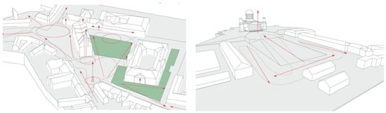
Figure 3.
Spatial focus analysis—“focus map” examples. green: green surface; red arrow: direction of the spatial focus and subfocus.
- Spatial Form as the Primary Focus
The geometric form of a space inherently defines one or more directional axes—foci—that guide orientation and movement. These primary foci are further shaped or counterbalanced by secondary foci, which emerge from variations in façade height, openness, or changes in the spatial layout.
- The Role of Spatial Scale
The size of a space significantly influences its focus structure. In large-scale spaces, multiple subspaces and corresponding focal points may emerge. In contrast, small spaces often emphasize verticality—such as the sky—as the dominant focus, potentially overriding all other spatial cues.
- The System of Foci and Their Effects
The character of a space is determined by the number and arrangement of its foci. Single-focus spaces tend to convey calmness and balance, while multi-focus spaces are perceived as dynamic and complex. Unique spatial experiences arise when the focus defined by the spatial form contradicts that of the façades, creating layered and multidimensional environments.
The primary function of spatial focus is to aid orientation and interpretation of space at a human scale. Literature in the field supports the notion that spatial directionality—or in this case, focus—is beneficial for spatial legibility and user experience [1,2,39,45,46].
3. Results
3.1. The Evolution and Patterns of Urban Square Quantities in the Hungarian Urban Network
The initial phase of the research involved a basic map-based survey of Hungarian cities, aiming to determine where urban squares exist, where they do not, and where there are potential candidates for inclusion in the study. The cities were categorized according to the following criteria:
- No square present.
- Only a proto-square exists.
- A defined square is present.
- Presence or absence of a continuous spatial network.
The reduced sample examined a total of 249 cities: in the area west of the Danube, the entire urban network was analyzed, while in the eastern part of the country, only cities with populations over 10,000 were included.
The results reveal a striking pattern: in nearly half of the cities, no genuine public square—understood in an urbanistic sense—can be identified. In total, 105 cities are entirely lacking such spaces (Figure 4).
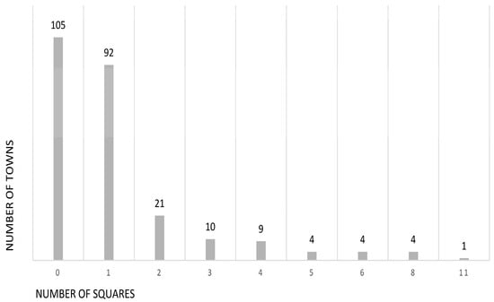
Figure 4.
Correlation between the number of defined urban squares and the number of towns.
A total of 112 cities have one or two defined squares, while only 32 cities possess three or more. This distribution reflects an unfavorable trend, suggesting that a significant portion of the Hungarian urban network lacks well-formed public squares that could function as true urban spaces with community significance (Figure 5).
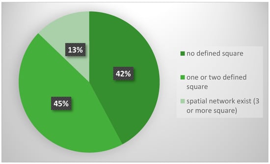
Figure 5.
The number of urban squares in Hungarian towns: no identifiable square, square-deficient, and continuous square fabric.
We identified 71 instances of square fragments or “proto-squares,” meaning areas that exhibit the potential for square formation but do not yet possess a developed spatial structure.
A striking observation was that many settlements classified as cities possess only one such square, or none at all. While some street-like spaces with defined edges exist, true urban squares are often absent or barely discernible.
During the survey of cities in Western Hungary, it became evident that significant squares are predominantly found in historically developed urban centers. Two main categories of cities emerged: those with only one or two squares—termed “square-poor” cities—and those with a more continuous network of public spaces. We were curious to find out how many of our cities have multiple squares, how many have a single square, and how many have none.
3.2. Morphological Categories Based on the Frequency of Occurrence and Spatial Analysis
Typological categorization appeared to be the most straightforward approach for several reasons. Firstly, spatial form is the clearest indicator of a square’s quality and degree of development. Secondly, squares with similar spatial configurations tend to exhibit comparable patterns in terms of use, traffic organization, and climatic behavior. Accordingly, our classification was primarily based on morphological categories derived from square-focused analysis. In cases where this proved insufficient—due to significant differences in size or function—we introduced special categories, such as small or oversized squares, thematic-focus squares, and tower-dominated and sloping squares.
Based on the spatial survey of the representative sample of the 94 squares and the deeply analyzed 55 squares (not included in the article because of the size limit), the following morphological categories were identified. The categories are based on the literature cited above, combining and specifying the categories of different spatial theories to the Hungarian spatial pattern (Figure 4):
- Triangular/trapezoidal squares;
- Double-triangle (grouped) squares;
- Grouped squares;
- Square-shaped squares;
- Square-shaped squares with central buildings;
- Rectangular squares;
- Street-like squares;
- Tower-dominated squares;
- Sloped squares;
- Giant (Large-scale) squares;
- Small-scale squares;
- Thematically focused squares;
- Modern squares.
Modern spaces are treated as a distinct category, as they are products of 20th-century urban planning principles. This includes suburban-type spaces, socialist realist spaces, and modernist spatial forms.
We examined the dominance of each square type both within the full set of 94 cases and within the reduced set of 55, where triangular or double-triangular squares show significant predominance (Table 1, Figure 6).

Table 1.
Morphological groups and squares studied.
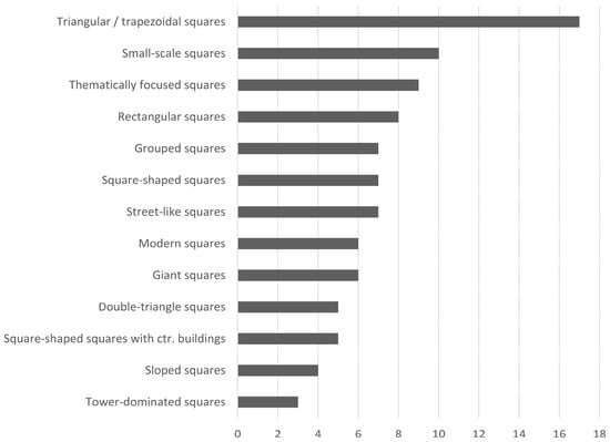
Figure 6.
Square range according to typology from 94 squares.
Morphological Characterization of the Analyzed Urban Square Types
- Triangular and Trapezoidal Urban Squares
Triangular or trapezoidal urban squares are among the most common spatial forms in Hungarian cities. They typically emerge at the intersection of two roads meeting at an acute angle, where the unbuilt area becomes an urban square. These forms often mark the terminal points of historic urban cores, as seen in Buda, Kőszeg, Esztergom, Sopron, and Székesfehérvár.
Morphologically, the focal point of such squares tends to align with either the apex of the triangle or the open side of the space. However, in many cases, the emphasis of the built environment does not correspond with the geometric focus of the square, creating a spatial tension. For example, in Székesfehérvár’s Szent István Square, the prominent façade of the County Hall is oriented along the long side of the triangle, emphasizing the longitudinal axis and enhancing the spatial enclosure. A similar phenomenon occurs in Tata’s Kossuth Square, where a church is inserted into one corner of the triangle, expanded by a lateral space.
Some squares emphasize openness, such as Debrecen’s Kossuth Square, where the massive volume of the Great Church dominates the open end, or Esztergom’s Town Hall, which occupies a similar position. In Szombathely, Vác, and Esztergom, triangular squares are often extended with additional spatial volumes, softening the dynamic of openness and transforming the triangle into a more rectangular main square (Figure 7 and Figure 8).
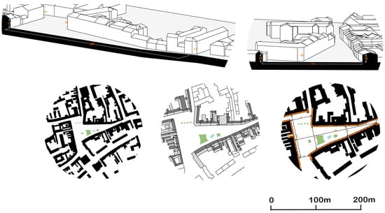
Figure 7.
Analysis of the Main square of Szombathely 3D sections, connecting urban tissue, site plan with green surface, and active ground floor. black/grey: buildings, orange strip: active ground floor, green: green surface, blue: water element.
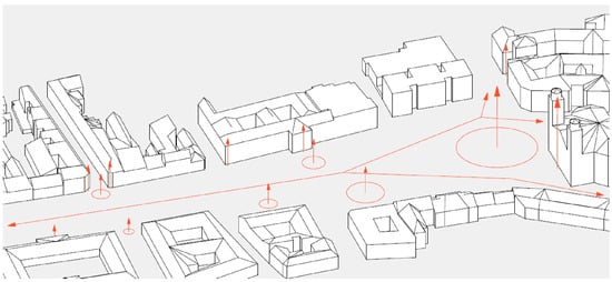
Figure 8.
The focus map of Debrecen Kossuth Square. red circle: area defined by the spatial focus; red arrow: direction of the spatial focus and subfocus.
Although this spatial type is characteristically medieval, its frequent occurrence has made it a persistent element in later urban developments. Their sizes vary widely, from a few thousand square meters up to 20,000 m2, with spatial proportions ranging from 1:2 to as much as 1:10.
In 80% of the cases, more than half of the square’s surface is dedicated to pedestrian use; however, the proportion of green space is generally negligible (under 30%) (Table 2).
Table 2.
Basic morphological data of triangular and trapezoidal urban squares.
- Double-Triangle (grouped) Squares
These unique composite squares are formed by the junction of two triangular squares. Their connection can occur at the apex (e.g., Vasvár, Veszprém—Széchenyi Square) or along their funnel-shaped sides (e.g., Székesfehérvár—Városház Square, Mezőberény—the junction of Kossuth and Városház Squares) (Figure 9).
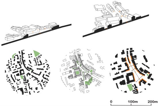
Figure 9.
Analysis of Vasvár Március 15 square 3D sections, connecting urban tissue, site plan with green surface, and active ground floor. black/grey: buildings, orange strip: active ground floor, green: green surface.
Due to their considerable size, the double-triangle configuration creates a strong spatial presence. Apex-connected squares generate a dynamic spatial experience, while funnel-shaped connections emphasize the directional flow between the two focal points.
Although these could be categorized among triangular forms, their distinctive inflection point generates a novel spatial relationship; therefore, they were assigned to a separate category.
Their sizes range between 5000 m2 and 15,000 m2, with spatial H/W ratio varying from 1:2 to 1:9. Based on these parameters, their dimensions fluctuate between those characteristic of street-like spaces and open squares, a variation that itself reflects a certain spatial tension. Roadway surfaces occupy a significant share at the expense of pedestrian areas and green spaces, with greenery generally being very limited, often not exceeding 30% (Table 3).
Table 3.
Basic morphological data of double-triangle (grouped) squares.
- Grouped Squares
This category includes squares formed by the connection of multiple squares without a dominant geometric form. Examples include the main square ensemble in Kiskunfélegyháza, the square group in Kunszentmiklós, or the paired Kossuth and Erzsébet Squares in Szentes, which meet at their corners (Figure 10).
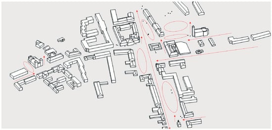
Figure 10.
The focus map of Kiskunfélegyháza central grouped square structure. Red circle: area defined by the spatial focus; Red arrow: direction of the spatial focus and subfocus.
These squares are characterized by the clear spatial definition of each component, allowing for a distinct experience when moving from one to another. Their large size and varied morphology create dynamic and engaging spatial relationships, often with open proportions exceeding 1:6.
As these cases involve the combination of multiple squares, their sizes range between 10,000 m2 and 30,000 m2. Compared to the other groups, they exhibit a more favorable balance of green and pedestrian surfaces, with both exceeding 40% of the total area (Table 4).
Table 4.
Basic morphological data of grouped squares.
- Square-Shaped Squares
Many Hungarian main squares exhibit a near-square layout, typically ranging from 80 to 150 m per side. Despite minor dimensional variations, these are classified as square-shaped due to their spatial character. While seemingly simple or even monotonous, this form can also convey spatial tension and complexity. These squares often date from the 19th century, though some, such as Győr’s Széchenyi Square or the square in front of the Basilica in Vác, originate from the Baroque period (Figure 11).
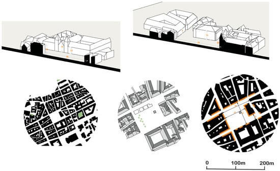
Figure 11.
Analysis of the Győr Széchenyi square of Szombathely 3D sections, connecting urban tissue, and site plan. black/grey: buildings, orange strip: active ground floor, green: green surface.
The square form inherently creates a central focus, which is nuanced by the orientation and width of incoming streets. For instance, in Hódmezővásárhely, a wide cross-axis divides the square, differentiating its four sides. In Győr, the spatial emphasis shifts due to the mass of the church embedded in the square’s edge and the freestanding Lloyd building, both competing for dominance.
Given their large size (6000–22,000 m2), these squares support mixed uses, accommodating both green spaces and paved areas suitable for major public events. Their volumetric proportions typically exceed 1:5, and due to low surrounding buildings, they often appear open. However, mature tree canopies frequently subdivide these large spaces into more intimate subsquares.
They feature substantial pedestrian surfaces (50–100%) and, due to their functional role, a comparatively modest proportion of green space (less than 30%) (Table 5).
Table 5.
Basic morphological data of square-shaped squares.
- Square-shaped squares Enclosing a Central Building
This group includes squares where a building—typically a church—occupies the center. In the simplest cases, such as in Hajdúböszörmény, the church stands within the square, which also serves as its forecourt. A more complex example is Pécs’s Széchenyi Square, where the mosque is elevated due to the sloping terrain. In Szekszárd’s Béla király Square, the church does not align with the square’s orientation, while in Pápa, the cathedral’s disproportionate scale compared to the surrounding buildings causes it to visually “drop out” of the square (Figure 12).
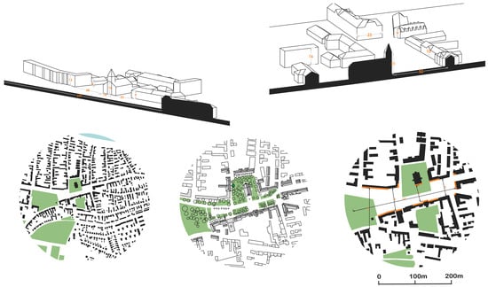
Figure 12.
Analysis of Csongrád Kossuth Square example for the Square-shaped squares Enclosing a Central Building 3D sections, connecting urban tissue, and site plan. black/grey: buildings, orange strip: active ground floor, green: green surface, blue: water element.
These squares are large in scale (more than 20,000 m2), with fundamentally open spatial proportions (exceeding 1:6) and insufficient green coverage, typically below 30% (Table 6).
Table 6.
Basic morphological data of square-shaped squares enclosing a central building.
- Rectangular Squares
Rectangular squares are relatively rare in Hungary, though notable examples include Szeged’s Klauzál Square and Sopron’s Széchenyi Square. Due to their elongated shape, these squares often divide into multiple spatial segments. In Klauzál Square, a major urban axis runs through the center, while Sopron’s Széchenyi Square functions as an expansion of the historic city ring (Figure 13).
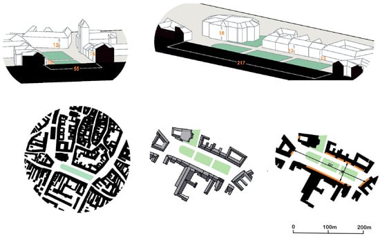
Figure 13.
Analysis of Sopron Széchenyi Square 3D sections, connecting urban tissue, and site plan. black/grey: buildings, orange strip: active ground floor, green: green surface.
In terms of size, these squares can be classified as medium-scale, ranging between 5000 m2 and 10,000 m2. Although they cannot be considered street-like spaces—as they possess a clearly defined spatial form—their height-to-width ratios, between 1:2 and 1:4, approach that of street spaces. Green coverage is minimal, generally below 30%, whereas pedestrian surfaces are substantial (Table 7).
Table 7.
Basic morphological data of rectangular squares.
- Street-like Squares
Urban spaces such as the central areas of Miskolc, Tapolca, and Békéscsaba can be classified as linear street-squares, each exhibiting distinct morphological and spatial characteristics. Despite their differences, a common feature is that other urban spaces in these cities often appear as extensions or closures of the main street-square. Their spatial proportions typically range between 1:6 and 1:3, with a strong emphasis on axiality and linear spatial organization.
These areas are characterized by a high proportion of paved surfaces at the expense of pedestrian spaces and exhibit a notable deficiency in green infrastructure, with vegetation cover remaining below 20% (Table 8).
Table 8.
Basic morphological data of street-like squares.
- Squares Defined by Vertical Accents—The Role of Towers
Certain urban squares are less defined by their horizontal spatial configuration and more by their vertical elements, particularly towers, which visually and symbolically structure the space. A notable example is Kaposvár’s main square, where the dominant church tower is visually balanced by two smaller towers on the opposite side. Similarly, in Szekszárd’s Béla király Square, the vertical emphasis of the church tower reinforces the spatial coherence of an otherwise irregular and sloping square. Other examples include Jurisics Square in Kőszeg and the main square of Sopron, where towers integrate harmoniously with the spatial form rather than dominating it (Figure 14).
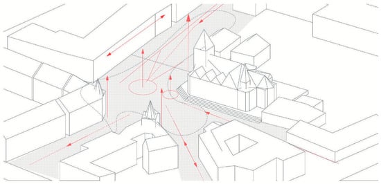
Figure 14.
The focus map of Kaposvár Kossuth Square. red circle: area defined by the spatial focus; red arrow: direction of the spatial focus and subfocus.
Their morphological characteristics and spatial layouts are not particularly relevant, as vertical elements dominate the area. Towers frequently occupy central positions along the space, resulting in a predominantly pedestrian-oriented environment (Table 9).
Table 9.
Basic morphological data of squares with a dominant tower.
- Sloped Urban Squares
A distinct category is formed by squares with significant topographical inclination (exceeding 6%). While many Hungarian squares exhibit mild slopes, only a few—such as those in Pécs and Sátoraljaújhely—feature pronounced gradients. In these cases, the spatial plane is fragmented into multiple levels, altering the spatial dynamics and perception of the square.
These squares exhibit medium-scale dimensions without distinctive size characteristics, with enclosure ratios ranging from 1:4 to 1:1. As principal urban squares, they demonstrate a clear pedestrian predominance (exceeding 60%), while vegetated areas are marginal, covering less than 30% of the total surface (Table 10).
Table 10.
Basic morphological data of sloped urban squares.
- Giant—Large-Scale Urban Squares
From a morphological perspective, Hungary’s large market and main squares represent a unique typology. One of the largest is Nagykanizsa’s main square, measuring approximately 250 × 100 m, bordered by low-rise (1–2 story) buildings. Similarly expansive are the main squares of Keszthely (approx. 170 m), Kecskemét (260 × 100 m), Szombathely (170 m), Pápa, Szeged (Széchenyi Square, 250 m—more of a park-square), Debrecen (160 m), Vác (180 m), Hajdúböszörmény (212 m including the church, 120 m without), Nyíregyháza (150 m), and Mór (Budai Nagy Antal Square, 300 m).
These squares demonstrate diverse approaches to spatial organization. For instance, Nagykanizsa’s square remains largely undivided and fully paved, resulting in a somewhat monotonous spatial experience. In contrast, Kecskemét’s main square is pleasantly segmented into two distinct parts by a building that projects into the space—one part is park-like, the other more urban in character. This category also includes L-shaped squares typical of dual-axis cities, such as those in Zalaegerszeg, Keszthely, and Székesfehérvár.
Their sizes range between 16,000 and 35,000 m2, and all convey the perception of open space, as their H/W ratios exceed 1:6. Despite their scale, green space proportions are not low (30–40%), while pedestrian areas can be considered adequate relative to their overall dimensions (Table 11).
Table 11.
Basic morphological data of giant squares.
- Small-Scale Urban Squares
Small urban squares—often no larger than one or two plots—typically emerge as residual spaces within the urban fabric. Examples include Hősök tere in Székesfehérvár, situated between the rear of a church and the street line, or Szent László Square in Mosonmagyaróvár, a leftover half-block between two streets. Due to their limited size, these squares often lack pronounced spatial enclosures and are not fully visible from within. As a result, they are perceived as intimate “urban rooms,” with their spatial emphasis directed vertically toward the sky.
Their sizes range from a few hundred to 6000 m2, with green space coverage at or below 20%. They exhibit compact H/W ratios, ranging from 1:2 to 1:6, and are generally characterized by pedestrian predominance (Table 12).
Table 12.
Basic morphological data of small squares.
- Thematic or Functionally Focused Squares
This category includes squares created with a specific thematic or functional focus, often serving a singular architectural or natural element. Examples include the square in front of the Esztergom Basilica, Dóm Square in Szeged, the lakeside square in Tapolca, and the Szinva Terrace in Miskolc. In these cases, the spatial form is secondary to the thematic or symbolic significance of the site. The square in Esztergom is oriented toward a nationally significant religious structure, while those in Miskolc and Tapolca are organized around natural water features.
In these spaces, the defining feature is not the open area itself but the building or other element situated within it; therefore, enclosure ratios are not a relevant metric. Their dimensions are generally substantial, allowing them to accommodate the given structure or feature, while pedestrian and green space proportions are within average ranges (Table 13).
Table 13.
Basic morphological data of thematic squares.
- Modern Urban Squares
This group encompasses not only modernist squares but also those developed according to explicit urban planning principles in the 20th century. Although these spaces could be categorized under previously discussed types, their distinct formal and functional characteristics warrant separate treatment. Examples include a workers’ housing estate square in Győr (Gyárváros), a socialist realist square in Kazincbarcika, and two modernist squares in Salgótarján and Dunaújváros.
A common feature of these squares is that, from a morphological perspective, they differ significantly from earlier square typologies, as their formation was generally influenced by specific urban planning theories. A representative example is the case of Győr, where the garden city ideal served as the conceptual basis for square design. Although the modernist era theoretically rejected the notion of the traditional public square, in Hungary, several prominent squares were nevertheless planned during the socialist realist period with a clear intention of spatial definition, resulting in distinct and legible spatial layout. At the same time, their built environment often reflects the principles of modernist spatial thinking: the enclosing façades are frequently fragmented or absent, and the built fabric is characterized by tower-like, freestanding structures that disrupt the traditional enclosure of the square (Figure 15).
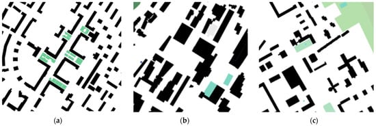
Figure 15.
Modern urban squares: (a) Kazincbarcika social realist main street, with squares attached; (b) Sátoraljaújhely main square, designed during the socialist realist period but constructed in the modernist era; (c) Dunaújváros main square, designed during the socialist realist period but constructed in the modernist era. black/grey: buildings, green: green surface, blue: water element.
Although often framed by tall buildings—occasionally including towers up to ten storeys—their average enclosure ratios approximate those of well-proportioned, pleasant urban squares, varying between 1:2 and 1:4. Their dimensions are predominantly medium in scale, with the exception of the large main square of Salgótarján and the main street of Kazincbarcika, which incorporates multiple square-like expansions. Green space coverage is generally low, typically below 30%, while pedestrian areas are optimal in relation to their overall size (Table 14).
Table 14.
Basic morphological data of modern squares.
4. Discussion
One of the less positive findings of this research is that, out of Hungary’s 348 cities, many lack genuine urban squares in urbanistic terms. Some locations referred to as “squares” are merely utilized street fragments, parks, or undeveloped space. Unfortunately, several cities have either stalled at a certain level of urbanization or never fully developed into urban environments, with no coherent spatial enclosures or structured environments that could genuinely qualify as urban squares. This presents a challenge, as urban squares are among the most complex elements of urban design. They serve as the living rooms of the city, where people gather and communities take shape.
In the case of smaller settlements, the renewal of public squares typically does not involve the creation of entirely new squares, but rather the resurfacing and architectural redefinition of existing central spatial situations. These interventions often aim to enhance the aesthetic and functional qualities of the space without fundamentally transforming its morphological structure.
There is a substantial body of literature that analyzes urban squares at a global or European level, but these studies do not focus on Hungary, and Hungarian public spaces are completely absent from them [34,35,36,37].
In recent years, Hungary has seen a more substantial engagement with urban image, which led to the development of a new urban planning tool, the Settlement Image Manual. However, this instrument is primarily oriented toward architectural rather than urbanistic perspectives in most cases [47].
We found no directly comparable research; however, there are studies that examine specific areas with a single, well-defined purpose.
There are parallel studies that examine the morphological characteristics of urban squares, defining analytical criteria for their form and quality. But these studies conducted a comparative analysis, with particular attention to post-socialist Central and Eastern European cities, identifying common features and developmental potentials [48].
Another study analyzed the morphology of public spaces in the historic center of Viterbo, Italy, linking spatial form to principles of sustainability. It highlighted how historical urban fabric shapes the functionality, accessibility, and environmental performance of these spaces. It analyzed a more limited area but used very similar analytical methods [49].
As no existing document provides a comprehensive inventory of urban squares by country or region, the proposition of systematically addressing them is entirely novel. Their density and presence may serve as an indicator of urban life. The typology of squares could also reveal regional variations, although in our case, such patterns were not distinctive and therefore were not examined. The scope of the research is constrained by the feasibility of enumeration and analysis, as no database allows for direct extraction of such data. Consequently, the only viable approach is the exhaustive survey and evaluation of all squares within each city. The evaluation criteria are not always entirely robust, as the scholarly literature often relies on aesthetic principles; in practice, the most measurable attributes are usage and function.
The national or regional focus on the presence of urban squares can be applied elsewhere, as it clearly reveals which urbanization processes are taking place and whether they genuinely contribute to development. A regionally focused analysis also encompasses areas with similar climatic conditions, in which case the relationships between the morphology of urban squares and the local climate, as well as potential development strategies, can be effectively adapted.
The surveying and classification of squares provide a solid foundation for defining subsequent tasks and development directions. The contents of individual data sheets can be utilized in a variety of ways for further research. These data enable the analysis not only of spatial proportions and morphological differences but also, since they record aspects of square function, serve as a basis for sustainability and functional analyses.
Spatial focus analysis, as a novel methodological approach, can be effectively applied in education, as it facilitates students’ understanding of the morphological characteristics of squares. Similarly, 3D modeling proves to be a valuable tool, as it is essential for simplifying spatial complexity and identifying key morphological elements. The resulting three-dimensional models can also be effectively utilized in further research.
Most of the examined squares appear to have stagnated at a certain stage of development, functioning as little more than street junctions or intersections. Even in larger urban contexts, many “main squares” are effectively widened segments of principal streets or modest expansions thereof (e.g., Békéscsaba and Miskolc). The most common square type identified is triangular or trapezoidal in form; the expansion, maintenance, and enhancement of these should be guided by shared strategic principles.
The established morphological categories can serve as a basis for climate-conscious renewal, as geometric characteristics can be directly linked to climatic considerations. For example, squares of similar shape and size tend to exhibit comparable wind and shading patterns. This line of investigation has already been initiated in a separate study, drawing on the current sample as a foundation.
It is also evident that Hungarian towns are not only deficient in the number of squares, but also in green coverage: only a small fraction exceeds 40%. Thus, regardless of geometric form, the incorporation of green surfaces represents a critical development priority. However, introducing greenery into historic squares can present challenges. Such interventions could be implemented as green-space enhancements that respect the specific spatial character and focal points of each morphological category—an approach for which the measurement indices developed in this research provide a practical framework.
5. Conclusions
Urban squares are among the primary victims of climate change, and the summer warming in urban habitats often reaches intolerable levels. Therefore, climate awareness and climate adaptation are indispensable in the morphological renewal of these spaces. Urban thermal comfort and the urban heat island effect are closely related to the height-to-width ratios and other morphological factors. In a further study, we specifically investigate how morphological groups can be linked to climate-adaptive renovations.
In the current era of the information society, public spaces have regained significance, both socially and in terms of urban design [41,42]. Despite this renewed importance, we do not observe a widespread, nationwide wave of spatial transformation sweeping through Hungarian cities. Although Hungary has experienced construction booms in the early 2000s and again in recent years, this momentum has not translated into the development of urban squares.
In certain cases, the stagnation of spatial development may be attributed to heritage protection regulations. Buildings of historical value are often preserved, even when their morphological positioning within the square is less than ideal. However, this is not the prevailing issue. Numerous spatial situations exist where the reconstruction of a few spatial frontages could result in the creation of well-defined, high-quality public spaces.
The transformation of existing proto-squares into fully developed urban spaces is rarely a planning objective—except in some larger cities where the formation of spatial enclosures is considered.
The resulting typology is a valuable tool as it allows researchers and practitioners to work with a measurable dataset and develop shared strategies based on the common characteristics identified.
Author Contributions
Conceptualization, A.A.S.; methodology, A.A.S.; validation, A.A. and S.B.; formal analysis, A.A., A.A.S. and S.B.; data curation, A.A. and S.B.; writing—original draft preparation, A.A.S.; writing—review and editing, S.B. and A.A.; visualization, A.A. and A.A.S.; supervision, S.B. All authors have read and agreed to the published version of the manuscript.
Funding
This study was prepared within the framework of the Hungarian Academy of Arts (MMA) Art Scholarship Programme (2018–2021) MPJ2018-1526553487-143.
Data Availability Statement
The original contributions presented in this study are included in the article. Further inquiries can be directed to the corresponding author.
Acknowledgments
We acknowledge the support given by the students of Landscape Architecture and Urban Systems Engineering between 2019 and 2021 at the Hungarian University of Agriculture and Life Sciences.
Conflicts of Interest
The authors declare no conflict of interest.
Correction Statement
This article has been republished with a minor correction to the Data Availability Statement. This change does not affect the scientific content of the article.
Appendix A
An example of the data sheets of each square: the first doubled page represents the historical evaluation of the square. The second represents the morphological and functional aspects: the size; the H/W ratio; the green and paved area ratio; the 3D model and focus map; and the drawings of the urban tissue, the site plan of the square, and two representative sections of the square.


Notes
| 1 | During the post-1990 urbanization process, the number of cities in Hungary increased from 190 to over 348 (Figure 1). Many of these newly designated cities are either young settlements or have grown out of the suburban zones of larger urban areas. As a result, they often lack a coherent urban fabric and do not possess urbanistically valuable public spaces. |
References
- Carmona, M. (Ed.) Public Places—Urban Spaces: The Dimensions of Urban Design; Architectural Press: Oxford, UK, 2004; ISBN 978-0-7506-3632-2. [Google Scholar]
- Zucker, P. Town and Square: From the Agora to the Village Green; 2. Printing; The MIT Press: Cambridge, MA, USA, 1973; ISBN 978-0-262-74005-0. [Google Scholar]
- Krier, R.; Rowe, C. Urban Space; 5. impr.; Academy Editions: London, UK, 1991; ISBN 978-0-85670-576-2. [Google Scholar]
- Sitte, C. The Art of Building Cities: City Building According to Its Artistic Fundamentals; Martino Publishing: Mansfield Centre, CT, USA, 2013; ISBN 978-1-61427-524-4. [Google Scholar]
- Meggyesi, T. Városépítészeti Alaktan; Terc: Budapest, Hungary, 2009; ISBN 978-963-9535-90-9. [Google Scholar]
- Simon, K.; Bariska, I.; Blazovich, L.; Fedeles, T.; Jankó, F.; Kücsán, J.; Szende, K.; Sárosi, E.; Szilágyi, M.; Szilágyi, Z.; et al. Buda I. Kötet (1686-Ig), Buda II. Kötet (1686–1848), Kecskemét, Kőszeg, Pécs, Sátoraljaújhely, Sopron, Szeged; Magyar Várostörténeti Atlasz; Budapest Főváros Levéltára-Magyar Tudományos Akadémia Bölcsészettudományi Kutatóközpont Történettudományi Intézete: Budapest, Hungary, 2010; ISBN 978-615-5635-07-6. [Google Scholar]
- Mendöl, T. Általános Településföldrajz; Felsőoktatási Jegyzetellátó Vállalat: Budapest, Hungary, 1957. [Google Scholar]
- Granasztói, G.; Szűcs, J. A Középkori Magyar Város; Magyar História; Gondolat: Budapest, Hungary, 1980; ISBN 978-963-280-456-9. [Google Scholar]
- Granasztói, P. Ember És Látvány Városépítészetünkben; Akadémiai Kiadó: Budapest, Hungary, 1972. [Google Scholar]
- Granasztói, P.; Czeizing, L. Szép Magyar Városok egy Építész Szemével; Corvina: Budapest, Hungary, 1978; ISBN 978-963-13-0199-1. [Google Scholar]
- Batár, A. Városaink az Ezredfordulón; Új Világ K: Budapest, Hungary, 2000; ISBN 978-963-85533-8-6. [Google Scholar]
- Lovra, É. Városok az Osztrák-Magyar Monarchiában: Városszövet-és Várostipológia, 1867–1918; Terc: Budapest, Hungary, 2019; ISBN 978-615-5445-65-1. [Google Scholar]
- Korompay, G.; Pogány, F.; Entz, G.; Gerő, L.; Genthlon, I.; Szappanos, J.; Rados, J.; Dercsényi, D.; Horler, M.; Horváth, B.; et al. Kecskemét, Miskolc, Pápa, Pécs, Sopron, Szeged, Tata, Vác, Veszprém; Városképek Műemlékek sorozat; Műszaki Könyvkiadó: Budapest, Hungary, 1956. [Google Scholar]
- Gerő, L. Törtenelmi Városmagok: A Fenyképeket Mihalik Tamás, a Szöveg Kötzi Térképeket Kiss Mariann Készitette; Épitészeti Hagyományok; Corvina: Budapest, Hungary, 1978; ISBN 978-963-13-0281-3. [Google Scholar]
- Gerő, L. Történelmi Városrészek; Műszaki Könyvkiadó: Budapest, Hungary, 1971. [Google Scholar]
- Gerő, L. Magyar Városképek; Építőipari Könyv-és Lapkiadó: Budapest, Hungary, 1953. [Google Scholar]
- Louf, R.; Barthelemy, M. A Typology of Street Patterns. J. R. Soc. Interface 2014, 11, 20140924. [Google Scholar] [CrossRef] [PubMed]
- Curdes, G. Stadtstruktur und Stadtgestaltung; 2. Auflage; Verlag W. Kohlhammer: Stuttgart, Germany; Berlin, Germany; Köln, Germany, 1997; ISBN 978-3-17-014294-7. [Google Scholar]
- Balázs, É.; Pogány, F.; Szentkirályi, Z. Terek És Utcák Művészete; Műszaki Könyvkiadó: Budapest, Hungary, 1960. [Google Scholar]
- Meggyesi, T.; Benkő Melinda, T. A Külső Tér: Fejezetek Egy Építészeti Térelmélethez; Műegyetemi Kiadó: Budapest, Hungary, 2004; ISBN 978-963-420-780-1. [Google Scholar]
- Meggyesi, T. Települési Kultúráink; Terc: Budapest, Hungary, 2008; ISBN 978-963-9535-72-5. [Google Scholar]
- Kissfazekas, K. Városközpontok az Államszocializmusban. In Proceedings of the PhD Disszertáció; BMGE: Budapest, Hungary, 2010. [Google Scholar]
- Bonta, J. A Magyar Építészet Egy Kortárs Szemével 1945–1960; Terc: Budapest, Hungary, 2008; ISBN 978-963-9535-65-7. [Google Scholar]
- Prakfalvi, E. Salgótarján. A Kádár-kor városépítésének paradigmája? Urbs Magy. Várostörténeti Évkv. 2011, 6, 147–160. [Google Scholar]
- Reinold, A. Urbanization Without Industrialization. Evidence from 19th-Century Hungary; WU Vienna University of Economics and Business: Vienna, Austria, 2023. [Google Scholar] [CrossRef]
- Pénzes, J.; Hegedűs, L.D.; Makhanov, K.; Túri, Z. Changes in the Patterns of Population Distribution and Built-Up Areas of the Rural–Urban Fringe in Post-Socialist Context—A Central European Case Study. Land 2023, 12, 1682. [Google Scholar] [CrossRef]
- Csorba, P.; Bánóczki, K.; Túri, Z. Land Use Changes in Peri-Urban Open Spaces of Small Towns in Eastern Hungary. Sustainability 2022, 14, 10680. [Google Scholar] [CrossRef]
- Balázs, D.; Fazekas, I.; Mester, T. Assessment of Long-Term Land Cover Changes and Urban Expansion in Cities of the Hungarian Great Plain Using CORINE Data and Historical Maps. Land 2025, 14, 1153. [Google Scholar] [CrossRef]
- Vasárus, G.L.; Lennert, J. Suburbanization within City Limits in Hungary—A Challenge for Environmental and Social Sustainability. Sustainability 2022, 14, 8855. [Google Scholar] [CrossRef]
- Sarihan, E.; Lovra, É. Uncovering Urban Palimpsest through Descriptive and Analytical Approaches to Urban Morphology—Understanding the Ottoman Urban Fabric of Bursa, Türkiye. Land 2024, 13, 1435. [Google Scholar] [CrossRef]
- Zhang, P.; Ghosh, D.; Park, S. Spatial Measures and Methods in Sustainable Urban Morphology: A Systematic Review. Landsc. Urban Plan. 2023, 237, 104776. [Google Scholar] [CrossRef]
- Zoványi, G. Structural Change in a System of Urban Places: The 20th-Century Evolution of Hungary’s Urban Settlement Network. Reg. Stud. 1986, 20, 47–71. [Google Scholar] [CrossRef]
- Szirmai, V. “Csinált” Városok; Gyorsuló idő; Magvető: Budapest, Hungary, 1988; ISBN 978-963-14-1193-5. [Google Scholar]
- Gatje, R.F. Great Public Squares: An Architect’s Selection, 1st ed.; Norton: New York, NY, USA, 2010; ISBN 978-0-393-73173-6. [Google Scholar]
- Jacobs, A.B. Great Streets; MIT Press: Cambridge, MA, USA, 1993; ISBN 978-0-262-10048-9. [Google Scholar]
- Lässig, K. Straßen und Plätze: Beispiele zur Gestaltung Städtebaulicher Räume; Institut für Städtebau und Architektur der Deutschen Bauakademie: Berlin, Germany, 1968. [Google Scholar]
- Jenkins, E. To Scale: One Hundred Urban Plans; Taylor and Francis: Hoboken, NJ, USA, 2012; ISBN 978-0-415-95400-6. [Google Scholar]
- Moughtin, J.C. Urban Design, 3rd ed.; Taylor and Francis: Hoboken, NJ, USA, 2007; ISBN 978-0-7506-5717-4. [Google Scholar]
- Gehl, J. Life Between Buildings: Using Public Space; Island Press: Washington, DC, USA, 2011; ISBN 978-1-59726-827-1. [Google Scholar]
- Cowan, R. Essential Urban Design: A Handbook for Architects, Designers and Planners; RIBA Publishing Ltd.: London, UK, 2021; ISBN 978-1-003-18061-6. [Google Scholar]
- Yeang, L.D. Urban Design Compendium; Llewelyn-Davies: London, UK, 2007. [Google Scholar]
- Ruddick, M. Wild by Design: Strategies for Creating Life-Enhancing Landscapes; SpringerLink Bücher: Berlin/Heidelberg, Germany; Island Press: Washington, DC, USA, 2016; ISBN 978-1-59726-949-0. [Google Scholar]
- Wertheimer, M. Untersuchungen zur Lehre von der Gestalt. II. Psychol. Forsch. 1923, 4, 301–350. [Google Scholar] [CrossRef]
- Palmer, S.E. Vision Science: Photons to Phenomenology; A Bradford Book; 3. printing.; MIT Press: Cambridge, MA, USA, 2002; ISBN 978-0-262-16183-1. [Google Scholar]
- Kaplan, S.; Kaplan, R. Cognition and Environment: Functioning in an Uncertain World; Praeger Special Studies; Praeger: New York, NY, USA, 1982; ISBN 978-0-03-062346-2. [Google Scholar]
- Cullen, G. Concise Townscape; Taylor and Francis: Hoboken, NJ, USA, 2012; ISBN 978-0-7506-2018-5. [Google Scholar]
- Teremy, V. A Településkép és a Települési Arculat Alakítása a Magyar Településtervezésben 2016–2022 Között. PhD Thesis, Magyar Agrár- és Élettudományi Egyetem, Budapest, Hungary, 2023; p. 213. [Google Scholar]
- Inesa, A. Kurtinaitienė Morphological Analysis of Squares in Europe’s Common Cultural Context. In Proceedings of the 3rd International Conference on “Changing Cities”: Spatial, Design, Landscape & Socio-Economic Dimensions, Syros-Delos-Mykonos, Greece, 26–30 June 2017; Grafima Publications: Thessaloniki, Greece, 2017. ISBN 978-618-5271-11-4. [Google Scholar]
- Maretto, M.; Gherri, B.; Chiovitti, A.; Pitanti, G.; Scattino, F.; Boggio, N. Morphology and Sustainability in the Project of Public Spaces. The Case of the Historic Centre of Viterbo (Italy). J. Public Space 2020, 5, 23–44. [Google Scholar] [CrossRef]


Disclaimer/Publisher’s Note: The statements, opinions and data contained in all publications are solely those of the individual author(s) and contributor(s) and not of MDPI and/or the editor(s). MDPI and/or the editor(s) disclaim responsibility for any injury to people or property resulting from any ideas, methods, instructions or products referred to in the content. |
© 2025 by the authors. Licensee MDPI, Basel, Switzerland. This article is an open access article distributed under the terms and conditions of the Creative Commons Attribution (CC BY) license (https://creativecommons.org/licenses/by/4.0/).