Article

An HUL Assessment for Small Cultural Heritage Sites in Urban Areas: Framework, Methodology, and Empirical Research

1
School of Landscape Architecture, Beijing Forestry University, Beijing 100083, China
2
Joint Lab of Heritage & Landscape Conservation by BFU and ICCROM, Beijing 100083, China
*
Author to whom correspondence should be addressed.
Land 2025, 14(8), 1513; https://doi.org/10.3390/land14081513
Submission received: 21 June 2025 / Revised: 15 July 2025 / Accepted: 19 July 2025 / Published: 23 July 2025

Abstract

The research is grounded in the perspective of urban historical landscape (HUL), exploring the connections between cultural heritage and a broader urban context, as well as the general public and communities. It also focuses on small cultural heritage sites (SCHSs) in urban areas that have been overlooked in previous studies. By integrating various types of data, an assessment framework and methodology comprising six dimensions and 24 indicators were established and applied to the empirical research of 30 SCHSs in the Beijing section of the Grand Canal. The empirical research demonstrated the operability, effectiveness, and flexibility of the HUL assessment for SCHSs. The research findings are as follows. (1) The method provides differentiated recommendations for the formulation of tailored policies and planning management schemes based on heritage types, conservation levels, and the urban districts in which they are located. (2) The comprehensive quality of the open spaces where SCHSs are situated is critical for the cognition of the general public and community residents. (3) The overall conservation of the community areas containing SCHSs is highly significant, and the linkage between social development levels and cultural resources enhances public cognition of the SCHSs. (4) Cluster analysis offers guidance for the refined improvement of different SCHSs. The research aims to establish an action-oriented assessment framework, with a dimensional framework responding to the requirements of HULs and allowing for indicator flexibility. This study is significant for supporting the conservation and utilization of SCHSs in urban areas and for promoting their sustainable development.

1. Introduction

Cultural heritage functions as a historical witness, a manifestation of unique characteristics, and a critical developmental resource in urban contexts [1]. The Convention for the Protection of the Architectural Heritage of Europe, which came into effect in 1987, mentioned that cultural heritage serves as a cultural reference for improving the environment, reflecting the pursuit of a balance between conservation and utilization, and emphasizing the importance of improving the environmental quality of cultural heritage, enhancing public spaces, and the significance of full-cycle public participation. In 2011, UNESCO promulgated the Recommendation on the Historic Urban Landscape [2]. The Historic Urban Landscape (HUL) approach is aimed at preserving the quality of human environments, enhancing the productive and sustainable use of urban spaces, while recognizing their dynamic character, and promoting social and functional diversity. It integrates the goals of urban heritage conservation and those of social and economic development. However, contemporary complex urban environments pose significant challenges to cultural heritage conservation, including the following: encroachments on heritage buffer zones by urban expansion, inappropriate uses of heritage sites, pressures from rising population density, inadequate management frameworks, climate change-driven environmental degradation, and insufficient public conservation awareness [3,4,5,6,7,8,9].
In response to these changes, the Heritage Impact Assessment (HIA) was proposed in 2011 to illustrate the possible impact of changes on OUV (Outstanding Universal Value), aiming to mitigate the negative impact of human activities on cultural heritage [10,11]. The HIA has been applied to multiple studies including historical urban renewal [12], assessing visual integrity and urban landscape preferences [5], urban representation [13], urban historical buildings [7], and historical gardens [14]. However, the HIA is considered to have limitations, including insufficient attention to living utilization, a lack of perspectives from different stakeholders, and a need to incorporate heritage values more proactively into urban planning and design [11,15,16]. Furthermore, cultural heritage has been proven to have a positive impact on community cohesion and the well-being of the individuals within a community [17,18]. In 2025, The Nairobi Outcome Document on Heritage and Authenticity emphasized that heritage is community-centered, pluralistic, dynamic, and evolving over time, and that its significance transcends the physical form. Therefore, there is an urgent need for a systematic and user-friendly heritage assessment method that combines heritage value with space and resources in multi-level urban environments, as well as with the public and communities, to address conservation challenges and proactive planning and design in complex environments [19,20].
Among cultural heritages, some sites, compared to the large and well-known monuments, are smaller in scale and have a more plain appearance, and thus fail to attract a large number of tourists. However, they still possess considerable cultural, historical, and socio-economic value [21,22,23]. These are referred to as small cultural heritage sites (SCHSs). The types and functions of SCHSs vary greatly, including archaeological sites, historic buildings, and local cultural landmarks [24,25]. In urban areas, SCHSs face additional risks, including the following: being more susceptible to urban development [26], being scattered and difficult to count [23], having their value overlooked and be hard to realize [27], as well as being isolated from the environment, the public, and the community [22,28]. Based on the Third National Cultural Relics Survey conducted in 2011, China registered a total of 766,722 immovable cultural relics, most of which belong to SCHSs. However, rapid urbanization has intensified the conflicts between the conservation cultural values/environments of SCHSs and meeting contemporary urban demands [29]. This dynamic has precipitated the degradation or contextual isolation of numerous SCHSs from their surroundings, the public, and their community [26,30]. Although legislation has effectively mitigated the direct destruction of these vulnerable assets [31], under the perspective of HUL, critical challenges persist in the assessment of the adaptive utilization of heritage [32], the integration with social vitality [33], and the incorporation of bottom-up public views into a conservation framework [34].
Within the HUL perspective, scholarly investigations predominantly address macro-scale analyses—encompassing cultural-historic districts [33,35], heritage communities [17], and linear heritage corridors [36]—alongside typological analyses of discrete elements such as historical buildings [7] and urban historical parks [37,38]. While SCHSs are intermittently referenced in such studies, systematic examinations of their distinctive attributes remain critically underdeveloped [39,40]. Furthermore, extant SCHS research has disproportionately emphasized physical attributes and historical significance, while neglecting their embedded socio-ecological contexts [41,42]. Concurrently, inadequate attention is given to relational dynamics between SCHSs and public stakeholders—particularly local communities’ perceptions, emotional attachments, and participatory engagement [43,44]. The paradigm of cultural heritage assessment in urban environments is evolving from unidimensional approaches toward integrated frameworks, synthesizing heritage ontology, multi-scalar environmental matrices, and public stakeholders (particularly communities) [45,46]. This transformation reflects the operational shift in heritage practice from static conservation to dynamic socio-ecological integration. The core research imperative should establish evidence-based frameworks for conservation and utilization in complex urban systems, while advancing adaptive governance mechanisms to enable sustainable heritage stewardship.
This research aims to propose an integrated assessment for SCHSs and an application method from the perspective of HUL. By integrating various data types such as official documents, geographic information data, social media data, field investigations, and interviews, the value of a SCHS itself is linked to an open space, community area, the general public, and community residents where it is located, in order to reveal the current situation and typical types of SCHS panorama, and explore improvement strategies based on the quantitative relationships among different dimensions and indicators. The research established six assessment dimensions including Heritage Value Characteristics (HVCs), Space Environment Characteristics (SECs), Area Social Development (ASD), Area Cultural Linkage (ACL), Public Cognitive Characteristics (PCCs), and Community Cognitive Characteristics (CCCs), as well as 24 indicators, and applied them to the empirical research of 30 SCHSs of the Beijing section of the Grand Canal.

2. Assessment Framework and the Path of Application

2.1. Assessment Framework: Six Dimensions and 24 Indicators

The HUL extends beyond the notion of a “historic center” or “ensemble” to include a broader urban context and its geographical setting, and emphasizes the perspectives of the public and the community to support the formulation of sustainable strategies that adapt to changes. Combined with a continuous deepening of the current understanding of the value of cultural heritage [47], the Assessment Framework has formulated six dimensions, involving the intrinsic value characteristics of SCHSs, the open spaces and community areas where the SCHSs are located, as well as the cognition of the public and community residents (Figure 1).
The Heritage Value Characteristics (HVCs) mainly focus on the diverse historical values of SCHSs and the current situation of their conservation and utilization. Among them, the diverse historical values not only include their conservation level, but also involve the characteristics of the rarity of the heritage types and historical depth. Also, taking into account the recommendation made that “Historic urban landscapes are urban areas where cultural and natural values and attributes have accumulated in layers throughout history”, emphasizing the placement of “past” heritage within the broader framework of contemporary urban development, to achieve dynamic, future-oriented sustainable urban development [2], the indicator “Conservation and utilization of heritage” was established.
The assessment framework defines the broader urban contexts referred to in the Recommendation [2] as the open space in which a SCHS is located and the community area in which the SCHS is situated, categorized into the three dimensions of Space Environment Characteristics (SECs), Area Social Development (ASD), and Area Cultural Linkage (ACL). The Space Environment Characteristics (SECs) are a comprehensive research dimension that focuses on the characteristics of the open spaces where SCHSs are located. They assess the ability and potential to attract, accommodate, and serve the general public and community residents, as well as how easily the public can access and experience these heritage resources, focusing on perceptibility, accessibility, and environmental coherence [48]. The SECs include four indicators: “Science education facilities”, “The openness of heritage open space”, “Peripheral visibility”, and “Harmony with surrounding features”.
Area Social Development (ASD) focuses on the overall development statuses of the community areas where the SCHSs are located, including multiple aspects such as social vitality, public service capacity, environmental quality, and public transportation accessibility. It is an important dimension for assessing the positive interaction between SCHSs and their community area development. ASD included seven indicators: “Size of population” is an indicator representing social vitality, and “Open space scale” and “Blue-green space scale” are indicators representing environmental quality. “Number of restaurants” and “Number of public toilets” are indicators of public service capacity, and the “Number of bus and subway stations and Parking lot scale” are indicators characterizing the accessibility of public transportation.
Area Cultural Linkage (ACL) focuses on the potential connections between SCHSs and other historical and contemporary cultural resources in a community area. It is a dimension for assessing the reciprocal relationship and promotion of SCHSs and an area’s culture. ACL included four indicators: “Whether the heritage site is located in a historical and cultural district” reflects the overall conservation situation of the area; “Number of other heritage sites” and “number of other heritage sites of the same heritage series” reflect the aggregation situation and linkage potential of regional historical resources; and “Number of other public cultural facilities” reflects the scale of the contemporary cultural facilities that have the potential to be utilized.
It is worth noting that in China, the flexible transition zone (1–3 km) mandated by the Law of the People’s Republic of China on Environmental Conservation balances ecological and socio-economic needs. Therefore, it is suggested that the 15 min living circle (within 1 km) be used as the basis for assessing the scope of ASD and ACL—capturing daily-life interactions, accessibility, and environmental coherence [49,50,51]. It ensures heritage conservation strategies that are both legally compliant and responsive to ground-level socio-cultural dynamics, embodying the HUL’s requirement for “layered, context-specific interventions.”
Regarding the intangible aspects of the context, the Recommendation mentions the following: “The Historic Urban Landscape approach draws on the traditions and perspectives of local communities while also respecting the values of both domestic and international societies”. This requires constructing the cognitive dimensions of a social group from two perspectives: the public and the community. Public Cognitive Characteristics (PCCs) are an important dimension used to reflect the popularity of SCHSs among the public. The public forms an important overall impression of a part of a city through the perception of a specific cultural heritage, which responds to the public’s values [33]. PCCs contain two indicators: “Number of social media mentions” characterizes the level of public awareness of a heritage, and “Number of field visits by tourists” characterizes the number of people who actually visit a site. Community Cognitive Characteristics (CCCs) focus on the relationship between community residents and SCHSs, which are important places for the activities of local communities [17,18]. The three indicators of CCCs characterize different levels of community attitudes toward SCHSs: “Familiarity degree of community residents,” “Conservation Willingness”, and “Identity of community residents”.

2.2. The Path of Application Method

A SCHS assessment has three application steps: (1) multi-type data collection; (2) dimensionless data and weight calculations; and (3) data analysis for monitoring and management applications.
Firstly, multi-type data for the indicators are obtained using the following specific methods: (A) Document Analysis: Analyze and compare the existing SCHS and relevant conservation regulations of the local area to identify indicators for data quantification. Official documents can be analyzed to determine the type, conservation level, and historical depth. (B) Field investigation: Assess the conservation and utilization status of the SCHS and the open space. “Conservation and utilization of heritage” and the four indicators of the SECs require researchers to conduct field investigations and evaluations based on the scoring criteria. (C) Geospatial data analysis: Using geospatial data platforms and GIS technology, calculate and analyze various indicators in the community area. (D) Social media data analysis: Collecting and analyzing public perception data through online social platforms, used to collect the “Number of social media mentions” and the “Number of field visits by tourists”. (E) Questionnaire surveys: Collect information about community residents’ familiarity degree, conservation willingness, and identity through questionnaires and field surveys. The type and connotation of data for each indicator is shown in Table 1.
Given the involvement of multiple dimensions and the significant heterogeneity of the data, a weighting decision mechanism was essential to synthesize interdisciplinary perspectives. Dimensionless normalization techniques were applied to standardize multivariate raw data. Subsequently, dimensional weights were determined through the Delphi method, with weights derived from expert consultations or stakeholder scoring. The Delphi Method ensures the scientific and rational distribution of indicator weights by integrating multiple rounds of expert feedback and iterative adjustments [52].
The analysis method for assessment results is open and can meet the needs of different studies and applications. Descriptive statistics and visual presentation can help to understand the overall picture of the assessment object in a “broader context, public and community perspective”, reveal outliers in the object and the interpretations based on different types of features, and also compare SCHSs and their environments and features to obtain a more optimized allocation of capital input. Meanwhile, exploring the quantitative relationships among different dimensions and indicators can be used to identify the key environmental indicators that affect the sustainable development of SCHSs (especially the impact on public and community perception). Of course, we can also formulate more refined planning, design, and management strategies through a cluster analysis of the assessment results. Due to the readability of the framework and the accessibility of the data, it can also be used for the continuous monitoring of SCHSs. Furthermore, this framework can also be used to assess policy impacts to optimize the decision-making process and formulate sustainable conservation and utilization plans for SCHSs.

3. Empirical Research on 30 SCHS in the Beijing Section of the Grand Canal

3.1. Research Object

Canals represent a significant category of World Heritage Sites, distributed across Asia, Europe, and the Americas. Canal heritage serves as a vital testament to the interplay among human history, technology, culture, and the natural environment within their respective regions. Furthermore, canals constitute an essential cultural resource and environmental asset for contemporary public life in these areas.
The Grand Canal was inscribed on the World Heritage List in 2014 and is composed of the Beijing-Hangzhou Grand Canal, the Sui-Tang Grand Canal, and the Zhejiang Eastern Grand Canal, linking 31 cities across northern and south eastern China. The Grand Canal of China satisfies four of the six World Cultural Heritage criteria—(i), (iii), (iv), and (vi)—highlighting its outstanding value in historical civilization, technology, ecology, spiritual culture, and economy. Over the past millennium, the Grand Canal has functioned as a crucial conduit for water conveyance and transportation for the cities and villages along its course, while also serving as a locus of public life and a prominent cultural landmark for local communities. As a large-scale water infrastructure, the Grand Canal encompasses not only extensive waterways and hydrological features but also a network of water gates, bridges, docks, warehouses, and the associated cultural landmarks and structures that facilitate water management and navigation. In contrast, these SCHSs are less widely recognized and are more dispersed within diverse urban environments. Nevertheless, SCHSs remain integral to the Grand Canal’s overall integrity and possess significant value for sustainable utilization [53].
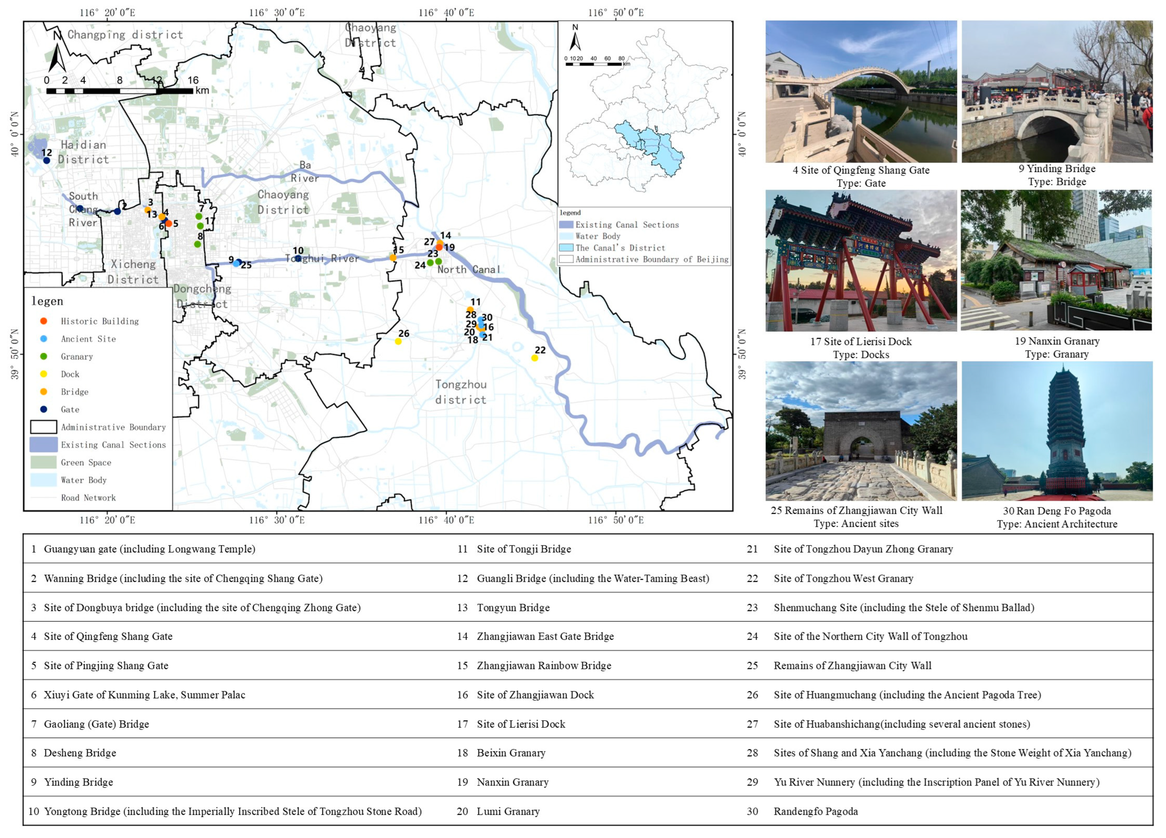
The Beijing section forms the northernmost segment of the Grand Canal. This study selected 30 SCHSs along the Grand Canal (Beijing Section), including historic buildings, ancient sites, bridges, water gates, docks, and granaries. For the purposes of this research, these SCHSs are numbered from 1 to 30 (Figure 2).

3.2. Data Collection and Analysis Steps

The data collection methods and scoring criteria for each indicator can be found in Supplementary Materials File S1, and the data sources can be found in Supplementary Materials File S2. Furthermore, to clarify the following key information is provided: (1) The statistical scope of the SECs is the open space where the SCHSs are located, while the statistical and investigation scope of the ACL, ASD, and CCCs take the community areas with a radius of 1 km (15 min living circle). (2) All field investigations in the research were conducted from 28 March 2024 to 23 September 2024, among which the questionnaires related to the CCCs were distributed from 8 September 2024 to 23 September 2024. (3) The number of social media mentions on Weibo, were collected from September 2023 to September 2024, and the number of field visits by tourists from Dianping, were collected from June 2006 to September 2024.
A total of 15 researchers and practitioners from fields such as cultural heritage, landscape architecture, and urban planning, after fully understanding the purpose of the research, compared the importance of different dimensions and indicators through questionnaires. Subsequently, the Delphi method was used to determine the weight of each indicator in each dimension, and its importance was expressed on a scale of one to five. The weight results obtained from the survey are referred to in Supplementary Materials File S3.
Based on the different types of data, use methods such as the breakpoint method to convert all indicators into a five-point system. The data of different dimensions are obtained by comprehensively calculating the indicators based on expert weights. This research conducted a three-step analysis: (1) Descriptive statistics of univariate variables, were used to present the panoramic assessment results and identify specific SCHSs. At the same time, it also analyzed the differences in performance among different heritage types, different conservation levels, and different urban districts in various dimensions. (2) Pearson’s correlation analysis was used to explore the relationships among the different dimensions, as well as the relationships between the 5 indicators of the PCCs and CCCs dimensions and the other 19 indicators, to reveal the key factors that have an impact on public and community cognition. (3) The Analyzing Hierarchical Clustering method was used to classify 30 SCHSs to discuss different types of features and targeted strategies.

3.3. Result

3.3.1. Univariate Analysis at the Dimensional Level

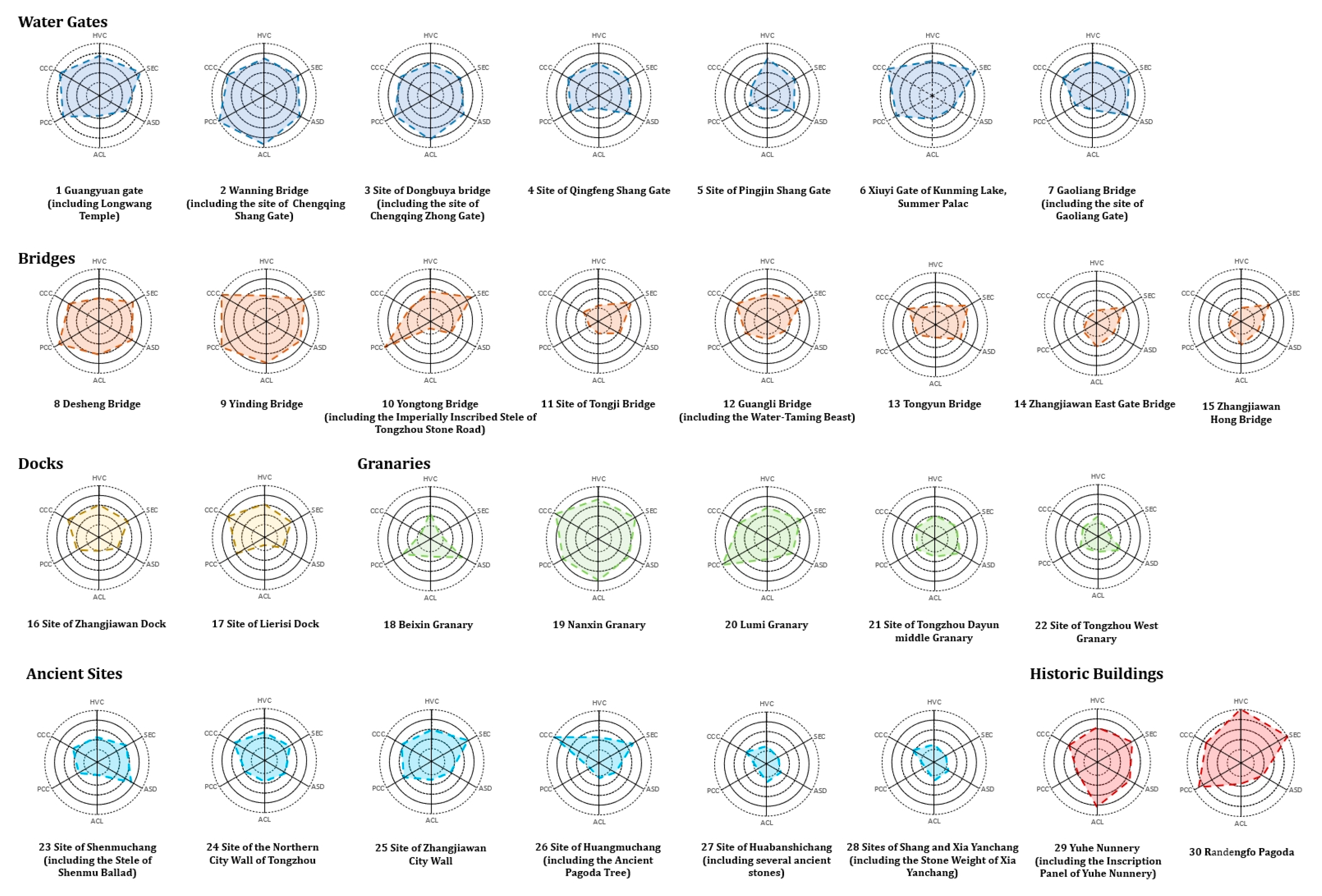
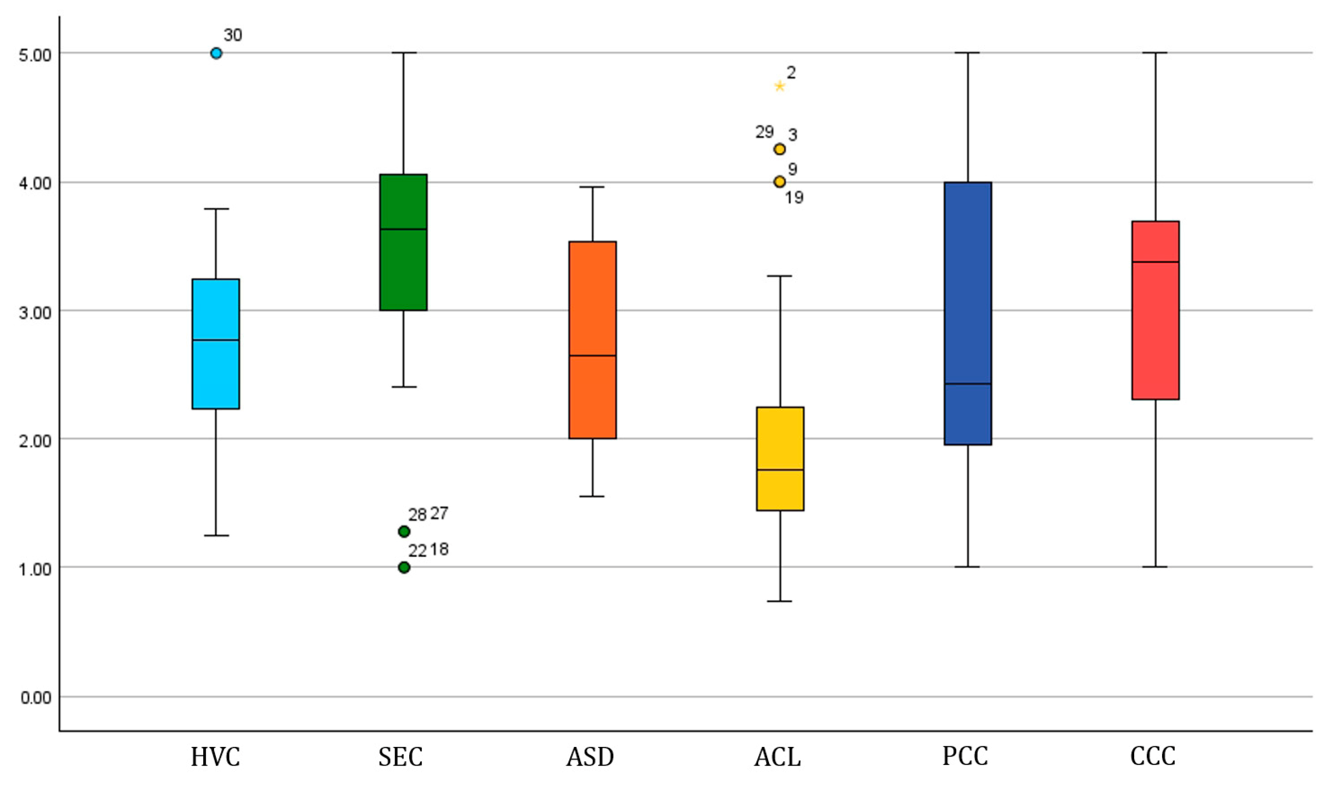
The assessment results of the indicators and dimensions of the 30 SCHSs are presented in Supplementary Materials File S4 (Figure 3 and Figure 4). In the HVCs dimension, the Randengfo Pagoda has the highest score alone, reflecting its comprehensive advantages in terms of conservation level, historical depth, scarcity, and conservation and utilization levels. The SECs show the highest overall level, indicating that the comprehensive level of the open spaces where most SCHSs are located is relatively high. The outliers of the SECs are mainly low values, existing in the Beixin Granary that was closed due to being occupied by units, as well as one granary and two ancient sites in a relatively remote area of Tongzhou. However, the overall level of ACL is relatively low, but the SCHS group located around Shichahai Lake and Yuhe River, as well as the newly updated Nanxin Granary, perform well as outliers. The dispersion of the PCCs is the highest among all the dimensions, indicating a significant difference in the cognition of the SCHSs of the Beijing section of the Grand Canal by the general public. By comparing PCCs with CCCs, it can be seen that the overall level and dispersion of community cognition are significantly better than those of PCC.
Table 2 provides a comparative analysis of the assessment results based on heritage type, conservation level, and urban district. From the perspective of heritage types, historical buildings perform best in the dimensions of HVCs, SECs, and ACL, and also rank among the top in other dimensions, indicating their advantages in heritage value, their overall conservation and utilization of the open space environment where they are located, their linkage of cultural resources, and their comprehensive level. A water gate is a distinctive type of cultural heritage in a canal’s heritage. It stands out in terms of ASD and PCCs, demonstrating the advantages in public cognition resulting from its close relationship with a canal’s course. The granaries received the lowest score for both SECs and CCCs, reflecting the problem of low community cognition due to poor location conditions. Although the community area conditions of the docks were the worst, their CCCs performance was the best, which may indicate that CCCs have little to do with the level of the community area. Bridges may have the poorest HVCs scores due to the rapid development of contemporary transportation. Ancient sites may have the poorest PCCs due to insufficient utilization potential.
The assessment results are generally associated with the conservation level, and an unrated SCHS performs the worst in all dimensions. National-level conservation SCHSs have the highest scores in HVCs and PCCs, highlighting their high popularity. District-level conservation SCHSs are superior in terms of SECs and CCCs, which may indicate that the legal restrictions brought about by high-level conservation may lead to an increase in an enclosure of the environment and community isolation issues.
The eastern and western parts of the urban area show obvious differentiation. The Haidian District (3 SCHSs) and the Xicheng District (3 SCHSs), located in the west, have significant advantages in all dimensions, while the Chaoyang District (3 SCHSs) and the Tongzhou District (16 SCHSs), located in the east, generally perform poorly in all dimensions due to reasons such as a high proportion of unrated SCHSs and poor environmental conditions.

3.3.2. Correlation Analysis

In the correlation analysis at the dimensional level (Table 3), we discovered the following interesting conclusion: SECs are significantly correlated with HVCs, indicating that high heritage value and conservation utilization levels will promote high-quality open spaces around SCHSs. Both PCCs and CCCs are influenced by HVCs and SECs, and PCCs are also additionally affected by ASD and ACL. This indicates that the value characteristics of SCHSs themselves are very important for the cognition of the general public and communities. However, compared with the cognition of the general public, which is influenced by multiple levels of environmental factors, the cognition of a community is only related to the open space where a SCHS is located.
Furthermore, we analyzed the correlations between the 5 indicators under the dimensions of PCCs and CCCs and the other 19 indicators (Table 4). From the analysis results of the two indicators of the PCCs, both social media attention and the number of tourists visiting in person will be affected by the level of conservation, utilization, popular science, visual visibility, and the overall conservation status of the historical block. The uniqueness of the influencing factors of social media attention stems from the level of public services and the aggregation level of historical resources and public cultural facilities in the community area. The number of tourists visiting in person is more affected by the social vitality and the scale of open spaces and blue–green spaces in the community area. From the analysis results of the three indicators in the CCC, it can be seen that they are all influenced by the level of conservation and utilization, the level of popular science, the degree of visual visibility, and the overall conservation status of the historical block. Regarding the two higher levels of conservation willingness and community identity, they were all affected by the SCHS level, the degree of coordination between the SCHS and the surrounding features, as well as the scale of open spaces and blue–green spaces in the community area. It is worth noting that only the conservation willingness of community residents was affected by the accessibility of the open space where the SCHS was located.

3.3.3. Cluster Analysis

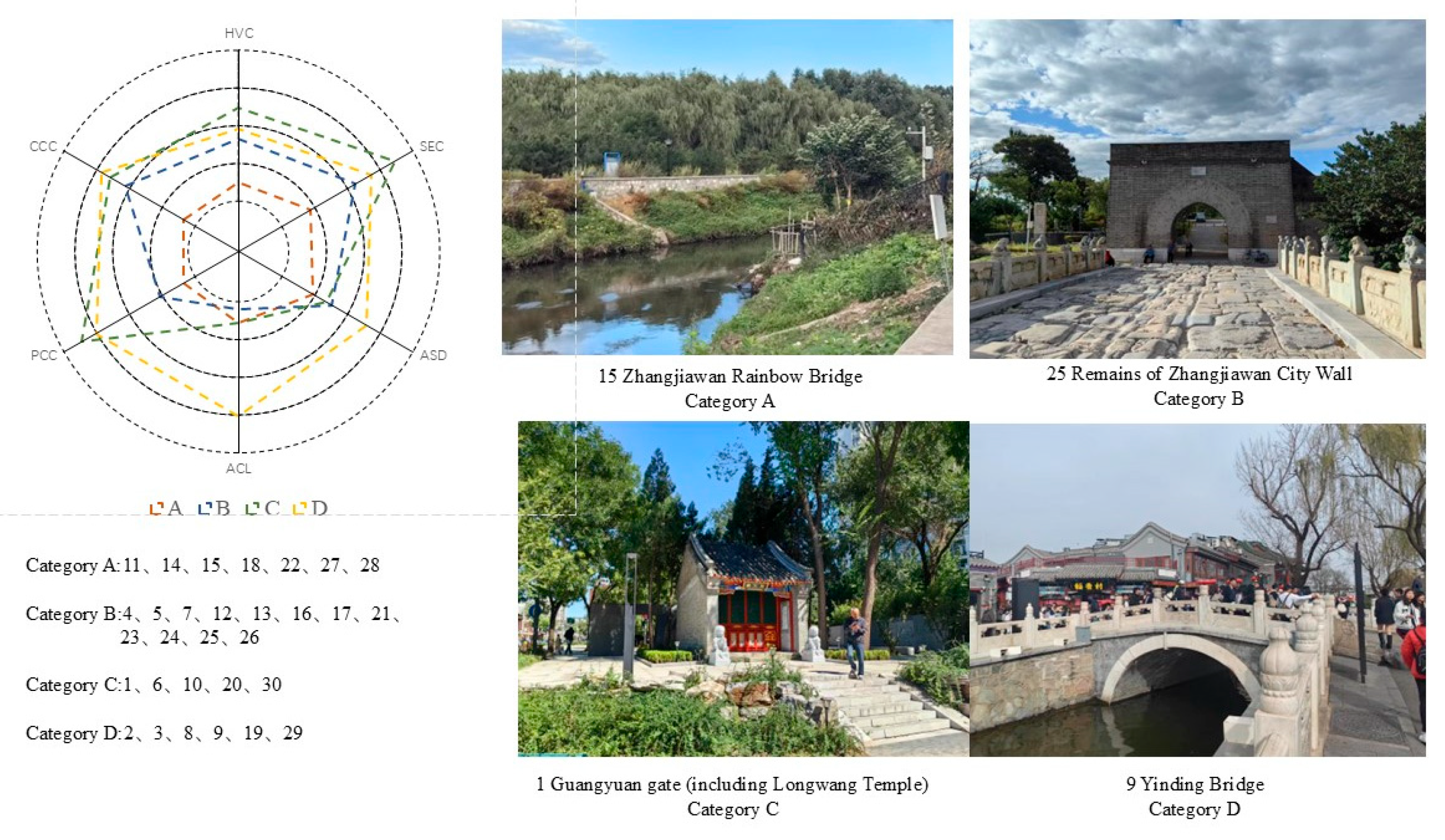
The Analyzing Hierarchical Clustering method was used to classify the 30 SCHSs into four categories according to the total dimension scores of the six dimensions (Figure 5). The comprehensive level of the assessment results gradually increased from category A to D. Category A had structural deficiencies in all dimensions, mostly including bridges, granaries, and ancient sites, and was mainly distributed in the Tongzhou Ancient City area and the Zhangjiawan area of Tongzhou. Through an on-site investigation, it was found that the conservation conditions of these SCHSs were poor, and the surrounding environment was rather desolate and dilapidated. The exception in category A was the Beixin Granary, which is located in the bustling Dongcheng District. However, due to the closed management of the area, its assessment result was not good. Category B had the largest number of SCHSs. Compared with category A, the main advantages of category B were HVCs, SECs, and CCCs. These SCHSs were mainly concentrated in the Tongzhou District and Chaoyang District, and the types were also very diverse. This further supported the conclusion in the previous text that the CCCs, HVCs, and SECs are closely related. Category C was the most unbalanced type. Its HVCs and SECs were the highest, and its PCCs and CCCs were also in the first rank along with category D. However, it was poor in ACL and ASD. The characteristics of the SCHS in this category included an excellent open space environment, but the distribution area was far from the other SCHSs, and the surrounding social development level was average. Category D had structural advantages in all dimensions and had the best-performing six SCHSs in the assessment framework of this study. Five of them were concentrated around Shichahai Lake and Yuhe River, demonstrating high aggregation and location advantages.

4. Discussion

4.1. The Advantages and Application Potential of the HUL Assessment for SCHSs

Compared with the HIA-related studies that mainly focus on the prevention of potential urban threats and pressures [10,11,54], the HUL assessment for SCHSs constructed in this study is an action-oriented proactive assessment method [15], which supports planning and management methods to achieve precise improvement and better sustainable development of SCHSs. The establishment of the assessment for SCHSs responds to the broader urban context and the perspectives of the public and community requirements of HUL [2,19], connecting the heritage value characteristics of SCHSs, the open space environments where they are located, and the community areas, as well as the viewpoints of the general public and community residents. It also makes up for the lack of attention to SCHSs in previous studies and assessments. By integrating various data types such as official documents, geographic information data, social media data, field investigations, and interviews, the standardization and visualization of the assessment data are achieved. The application of 30 SCHS assessments in the Beijing section of the Grand Canal also demonstrates the feasibility, effectiveness, and potential of the application of the assessment results of this method.
This research has demonstrated the following potential application scenarios of the HUL assessment framework for SCHSs: (1) Long-term monitoring of the overall situation of SCHSs in urban areas, identifying anomalous SCHSs in terms of heritage value characteristics, different environmental levels, and the cognition of the general public and community residents. (2) Revealing the characteristics of a series of SCHS under different classifications such as type, location, and level, to verify the effectiveness of relevant planning and policies and support the generation of optimization strategies. (3) Classifying SCHSs to precisely formulate targeted planning, design, and implementation strategies. (4) Exploring the relationships between the heritage value characteristics, environmental characteristics, and cognitive characteristics of SCHSs of specific series or regions in dimensions and indicators, explaining the interaction mechanisms, and revealing key spatial regulatory factors. The flexibility in the selection of indicators for this assessment means that it is not a fixed input–output process. Instead, it will be constantly updated in response to changes in the assessment goals, shifts in global perspectives, and the particularities of local concepts. At the same time, the various possibilities of the assessment results can also help us to understand the local characteristics of a heritage environment and policies, and provide more insights into the current situation of global urban heritage.

4.2. Comparative Analysis and Implications Based on Empirical Research

The consideration of the viewpoints of the general public and community residents has been proven to have significant value in the conservation and utilization of heritage sites [16]. These values are manifested in the roles they play in the formulation of heritage management policies [34,55], the realization of the sustainable value of heritage [56], and the identification of heritage [57]. Therefore, this research, by classifying the perceiving subjects, further clarifies that in the spatial environment, the cognition of the general public is influenced by multiple levels of the environment, while the cognition of community residents mainly depends on the smaller spatial scope of the open space where the SCHS is located.
In the dimension of HVCs, this research further demonstrated through the case of the Beijing section of the Grand Canal the significance of a high conservation level of a SCHS for the optimization of its surrounding environment and public cognitive. Compared with previous studies [58], this research further found that conservation level does not affect the familiarity degree of community residents, but only affects high-level cognitions such as conservation willingness and identity recognition. At the same time, this study demonstrated that the high-level conservation and utilization of cultural heritage in the current context can comprehensively enhance the cognition of different entities [59]. In the dimension of SECs, this research proved that high-level scientific popularization facilities and high visibility of the environment can comprehensively enhance the different cognitions of the public and community residents [48,60,61]. This viewpoint is applicable to SCHSs and is also prompted by the complexity and confinement of the environment where SCHSs are located, which should lead us to explore more innovative scientific popularization facilities such as community heritage museums relying on digital technology. At the same time, through removing fences, opening up views, and setting up more guiding signs, we can enhance the visual perception opportunities of the public for SCHSs. Moreover, the accessibility and harmonious landscape features of the open spaces where SCHSs are located are also important [4,62]. These measures enable community residents to have organic and long-term interactions with SCHSs, allowing community residents to truly regard SCHSs as a part of their community. In the dimension of ASD, the social vitality brought by high-density population concentrations is the guarantee for the visits of the public to SCHSs. At the same time, this research also refined the previous research viewpoints [4,63,64], that the scale of open space and blue–green space in a community area is the key influencing factor for ensuring visits by the public to a SCHS and the cognition of high-level community residents. In the dimension of ACL, the official delineation of the overall historical district as well as the resulting systematic construction activities and brand promotion are important for all the dimensions of public and community residents’ cognition [65]. This indicates the importance of overall conservation and utilization in a broader urban context. Additionally, this research found that the aggregation of historical cultural resources and contemporary public facilities has influenced society’s attention to SCHSs, but has not had a significant impact on the public’s on-site visits. This may be an interesting discovery in the formation mechanism of the popularity of cultural heritage in the current social media era. In the above conclusion, the high level of conservation and utilization of a SCHS, the accessibility, visibility, and coordination of the open spaces in which a SCHS is located, as well as the size of the green and blue spaces in the community area, all reached the same conclusion as those in previous studies in other regions around the world. This is conducive to supporting the formulation of some global heritage revitalization policies.
The conclusions of this research also contribute to the refinement of local policies and the identification of key objects for heritage-related actions. The open space where a SCHS is located serves as an important intermediary space that bridges cultural heritage with the city and the public. It plays a crucial role in the conservation of the SCHS, coordinating the visual environment, and generating the contemporary value of the SCHS. At the same time, enhancing the development level of the community area where a SCHS is located and strengthening the connection between historical and contemporary cultural resources in the community area is of great significance in drawing public attention to the SCHS. Finally, the disparity in the public and community’s cognition of SCHSs calls for us to enhance cooperation among different departments in order to ensure fairness in access to historical and cultural resources by different groups. Moreover, in the classification comparison, the level of open space where a national-level SCHS is located, and the community perception level are inferior to those of district-level heritage. This prompts us to reflect on the limitations of the current protection laws and regulations regarding the protection requirements for high-level heritage spaces. Discovering how to adopt more flexible policies and a “bottom-up” approach to protect high-value SCHSs, while making the surrounding environment more open to promote community integration of the heritage, is of great significance in generating the contemporary value of a SCHS.
Regarding the conservation and utilization actions of the Beijing section of the Grand Canal SCHSs, both the Tongzhou District and Chaoyang District have large-scale world heritage waterways. However, they should also devote more efforts to formulating specific plans to improve the environmental quality around the numerous Grand Canal SCHSs, and in some areas with limited spatial conditions, consider strengthening the connection between the public, community residents, and the SCHSs through cultural activities, digital displays, etc. This research also indicates that the conservation and utilization of SCHSs require the collaboration of multiple government departments and teams [5], as well as the deep participation of the public and community residents. This research has identified four types of SCHSs in the Beijing section of the Grand Canal, revealing that further field investigations have shown that category A should start with the conservation, restoration, and environmental improvement of the SCHS itself, especially by innovatively activating its contemporary value. At the same time, this process should actively leverage the role of community residents. Through investigation, we found that most community residents are aware of the existence of SCHSs, but they do not understand the historical value of these SCHSs, nor do they consider their potential for aesthetic and spiritual value. Category B has great potential. Although the community area conditions of this type of heritage are limited, it already has good environmental conditions and community identity. Therefore, its surrounding social service capabilities should be appropriately optimized, and the other material and intangible cultural resources around it should be fully explored to enhance the cultural resource linkage, in order to improve the awareness of the general public who are not living in the surrounding communities. Categories C and D are both SCHSs that should be maintained and monitored for their characteristics and advantages over a long-term period. Especially for category C, efforts should be made to strengthen the surrounding service capabilities and cultural linkage as much as possible, providing a basic guarantee for its sustainable development.

4.3. Limitation

Furthermore, it should be noted that this research has certain limitations:
(1)
The environments, cultural backgrounds, and stages of social and economic development in different cities are all different, and there are also significant differences in the goals of diverse assessments. Therefore, as an action-oriented proactive assessment method, the selection of indicators in this study has limitations for different research objects and environments in the future. The value of the six dimensions constructed in this study is much greater than the selected indicators. As a framework from the HUL perspective, it requires a flexible selection of indicators to adapt to the needs of the assessment. For instance, the refinement of personnel characteristics such as age, educational level, and ethnicity should be carried out [66,67]. In terms of the sources of viewpoints, relevant government organizations and profit-making institutions should be included [68]. In the viewpoints themselves, more diverse types including negative attitudes should also be incorporated. A broader environment often means the emergence of more inconsistent voices; these voices should be regarded as important references for continuously optimizing policies and actions for the conservation and utilization of heritage, and will also be conducive to enriching a diverse contemporary understanding of the urban historical landscape in areas with high heritage potential.
(2)
This research failed to adequately consider the potential risks that might exist in the environment where a SCHS operates. Current studies have shown that these risks could stem from physical factors such as climate change [69], or from excessive commercialization resulting from improper use [70].
(3)
The weights of the dimensions and the acquisition of some information in the assessments are determined through manual judgment. This may lead to inconsistent results due to differences in viewpoints among different assessors. In the future, digital instruments and artificial intelligence technologies can be combined to achieve a transformation from subjective evaluation to scientific quantification. However, at the same time, the long-term requirements of the assessment should also be considered, and a balance should be achieved between scientificity and efficiency. Since there are only 30 SCHSs in the Beijing section of the Grand Canal, the sample size has certain limitations. In the future, research can be conducted on a larger number of SCHSs in specific areas, which will help improve the accuracy of the impact mechanism research and also promote the exploration of more diverse application methods of this assessment framework.

5. Conclusions

The research established an assessment framework and method applicable to SCHSs from the perspective of HUL. As a result-oriented HUL assessment method, it integrates and standardizes various types of data, and links the value of SCHSs with a broader urban context, the public, and community residents through six dimensions (HVC, SEC, ASD, ACL, PCC, CCC) and 24 indicators. It has been effectively applied in an empirical study of 30 SCHSs in the Beijing section of the Grand Canal.
The research results demonstrate the operational methods, effectiveness, and potential usage of the HUL Assessment for SCHSs that was established. The research presents a comprehensive visualization assessment result of 30 SCHSs along the Beijing section of the Grand Canal, and also discovers the following core conclusions: (1) The six dimensions exhibit distinct characteristics in the typological studies of heritage types, conservation levels, and urban districts, which provides a basis for the formulation of differentiated policies and planning management schemes for SCHSs. (2) The level of popular science facilities, visibility, accessibility, and environmental harmony of the open spaces where SCHSs are located have a comprehensive impact on the cognition of the general public and community residents. (3) The overall conservation level of the community areas where SCHSs are located is of great significance to the general public and community residents, and the level of social development and the degree of integration of cultural resources will affect the public’s attention and visitation to a SCHS. (4) The results of the clustering study can effectively assess the characteristics of the 30 SCHSs in the Beijing section of the Grand Canal and generate optimization suggestions.
The HUL assessment for SCHSs holds significant value in its dimensions, and in terms of indicators, it can generate more flexible options by combining with the assessment goals. In the future, by integrating digital technology and exploring a greater number of SCHSs, this method can be used to achieve more precise assessments and explore more precise mechanisms of influence. This research, from the perspective of HUL, attempts to explore an action-oriented assessment method, also responding to the requirements in the Convention for the Protection of the Architectural Heritage of Europe regarding the balance between conservation and utilization, as well as the importance of public participation. It can provide a targeted assessment method for the overlooked SCHSs in current urban areas, in order to seek more proactive support for the systematic conservation and sustainable development of urban cultural heritage.

Supplementary Materials

The following supporting information can be downloaded at https://www.mdpi.com/article/10.3390/land14081513/s1: File S1. The collection methods and scoring criteria for 24 indicators. File S2. The data sources for 24 indicators. File S3. The results of indicator weights within different dimensions. File S4. The assessment results of the indicators and dimensions of 30 SCHSs.

Author Contributions

S.Z., conceptualization, methodology, investigation, funding acquisition, writing—original draft, writing—review and editing; H.S., methodology, investigation, writing—review and editing. M.J., data collection. J.Z., data curation, software, visualization. All authors have read and agreed to the published version of the manuscript.

Funding

The research was funded by the Youth Project of the Beijing Social Science Foundation (19SRC012).

Data Availability Statement

The raw data supporting the conclusions of this article will be made available by the authors on request.

Conflicts of Interest

The authors declare no conflicts of interest.

Abbreviations

The following abbreviations are used in this manuscript:
HULHistoric Urban Landscape
HIAHeritage Impact Assessment
SCHSsSmall Cultural Heritage Sites
HVCsHeritage Value Characteristics
SECsSpace Environment Characteristics
ASDArea Social Development
ACLArea Cultural Linkage
PCCsPublic Cognitive Characteristics
CCCsCommunity Cognitive Characteristics

References

  1. Tweed, C.; Sutherland, M. Built Cultural Heritage and Sustainable Urban Development. Landsc. Urban Plan. 2007, 83, 62–69. [Google Scholar] [CrossRef]
  2. UNESCO. Recommendation on the Historic Urban Landscape. In Proceedings of the Records of the General Conference 36th Session, Paris, France, 25 October–10 November 2011. [Google Scholar]
  3. Sesana, E.; Gagnon, A.S.; Bonazza, A.; Hughes, J.J. An Integrated Approach for Assessing the Vulnerability of World Heritage Sites to Climate Change Impacts. J. Cult. Herit. 2020, 41, 211–224. [Google Scholar] [CrossRef]
  4. Wu, J.; Lu, Y.; Gao, H.; Wang, M. Cultivating Historical Heritage Area Vitality Using Urban Morphology Approach Based on Big Data and Machine Learning. Comput. Environ. Urban Syst. 2022, 91, 101716. [Google Scholar] [CrossRef]
  5. Ashrafi, B.; Kloos, M.; Neugebauer, C. Heritage Impact Assessment, beyond an Assessment Tool: A Comparative Analysis of Urban Development Impact on Visual Integrity in Four UNESCO World Heritage Properties. J. Cult. Herit. 2021, 47, 199–207. [Google Scholar] [CrossRef]
  6. Agapiou, A.; Alexakis, D.D.; Lysandrou, V.; Sarris, A.; Cuca, B.; Themistocleous, K.; Hadjimitsis, D.G. Impact of Urban Sprawl to Cultural Heritage Monuments: The Case Study of Paphos Area in Cyprus. J. Cult. Herit. 2015, 16, 671–680. [Google Scholar] [CrossRef]
  7. Ornelas, C.; Sousa, F.; Guedes, J.M.; Breda-Vázquez, I. Monitoring and Assessment Heritage Tool: Quantify and Classify Urban Heritage Buildings. Cities 2023, 137, 104274. [Google Scholar] [CrossRef]
  8. Gu, Z.; Tian, D. Public Participation in the Conservation and Management of Canal Cultural Heritage Worldwide: A Case Study of the Rideau Canal and Erie Canal. Humanit. Soc. Sci. Commun. 2024, 11, 1005. [Google Scholar] [CrossRef]
  9. Veillon, R. State of Conservation of World Heritage Properties—A Statistical Analysis (1979–2013); UNESCO World Heritage Centre: Paris, France, 2014. [Google Scholar]
  10. Pereira Roders, A.; Van Oers, R. Guidance on Heritage Impact Assessments: Learning from Its Application on World Heritage Site Management. J. Cult. Herit. Manag. Sustain. Dev. 2012, 2, 104–114. [Google Scholar] [CrossRef]
  11. Patiwael, P.R.; Groote, P.; Vanclay, F. Improving Heritage Impact Assessment: An Analytical Critique of the ICOMOS Guidelines. Int. J. Herit. Stud. 2019, 25, 333–347. [Google Scholar] [CrossRef]
  12. Seyedashrafi, B.; Ravankhah, M.; Weidner, S.; Schmidt, M. Applying Heritage Impact Assessment to Urban Development: World Heritage Property of Masjed-e Jame of Isfahan in Iran. Sustain. Cities Soc. 2017, 31, 213–224. [Google Scholar] [CrossRef]
  13. Ginzarly, M.; Teller, J. Eliciting Cultural Heritage Values: Landscape Preferences vs Representative Images of the City. J. Cult. Herit. Manag. Sustain. Dev. 2018, 8, 257–275. [Google Scholar] [CrossRef]
  14. Fu, L.; Zhang, Q.; Tang, Y.; Pan, J.; Li, Q. Assessment of Urbanization Impact on Cultural Heritage Based on a Risk-Based Cumulative Impact Assessment Method. Herit. Sci. 2023, 11, 177. [Google Scholar] [CrossRef]
  15. Rodwell, D.; Turner, M. Impact Assessments for Urban World Heritage: European Experiences under Scrutiny. Built Herit. 2018, 2, 58–71. [Google Scholar] [CrossRef]
  16. Yung, E.H.; Chan, E.H. Problem Issues of Public Participation in Built-Heritage Conservation: Two Controversial Cases in Hong Kong. Habitat Int. 2011, 35, 457–466. [Google Scholar] [CrossRef]
  17. Li, H.; Ikebe, K.; Kinoshita, T.; Chen, J.; Su, D.; Xie, J. How Heritage Promotes Social Cohesion: An Urban Survey from Nara City, Japan. Cities 2024, 149, 104985. [Google Scholar] [CrossRef]
  18. Power, A.; Smyth, K. Heritage, Health and Place: The Legacies of Local Community-Based Heritage Conservation on Social Wellbeing. Health Place 2016, 39, 160–167. [Google Scholar] [CrossRef] [PubMed]
  19. Guzmán, P.C.; Roders, A.P.; Colenbrander, B.J.F. Measuring Links between Cultural Heritage Management and Sustainable Urban Development: An Overview of Global Monitoring Tools. Cities 2017, 60, 192–201. [Google Scholar] [CrossRef]
  20. Riganti, P.; Nijkamp, P. Valuing Cultural Heritage Benefits to Urban and Regional Development. In Proceedings of the 44th Congress of the European Regional Science Association: “Regions and Fiscal Federalism”, Porto, Portugal, 25–29 August 2004. [Google Scholar]
  21. Grimwade, G.; Carter, B. Managing Small Heritage Sites with Interpretation and Community Involvement. Int. J. Herit. Stud. 2000, 6, 33–48. [Google Scholar] [CrossRef]
  22. Palumbo, G.; Al-Tikriti, W.Y.; Mahdy, H.; Al Nuaimi, A.; Al Kaabi, A.; Altawallbeh, D.E.; Ali Muhammad, S.; Marcus, B. Protecting the Invisible: Site-Management Planning at Small Archaeological Sites in al-Ain, Abu Dhabi. Conserv. Manag. Archaeol. Sites 2014, 16, 145–162. [Google Scholar] [CrossRef]
  23. Khodadadi, M.; Pezeshki, F.; O’Donnell, H. Small but Perfectly (in) Formed? Sustainable Development of Small Heritage Sites in Iran. J. Herit. Tour. 2022, 17, 74–90. [Google Scholar] [CrossRef]
  24. Palka, J.W. A Small Rural Travel Stopover at the Late Postclassic Maya Site of Mensabak, Chiapas, Mexico: Overland Trade, Cross-Cultural Interaction and Social Cohesion in the Countryside. Camb. Archaeol. J. 2024, 34, 213–230. [Google Scholar] [CrossRef]
  25. Erny, G. Statistical Approaches to Small Site Diversity: New Insights from Cretan Legacy Survey Data. J. Mediterr. Archaeol. 2023, 36, 71–101. [Google Scholar] [CrossRef]
  26. Gruber, S. Protecting China’s Cultural Heritage Sites in Times of Rapid Change: Current Developments, Practice and Law. Asia Pac. J. Environ. Law 2007, 10, 253. [Google Scholar]
  27. Tantinipankul, W. Thailand’s Neglected Urban Heritage: Challenges for Preserving the Cultural Landscape of Provincial Towns of Thailand. Int. J. Tour. Anthropol. 2013, 3, 114–129. [Google Scholar] [CrossRef]
  28. Ali, M.A.; Abouelfadl, H. Stitching the Gap between Contemporary Archaeology and the City through “URBAN DOTS”: Case Study of Kōm al-Nāḍūra Area, Alexandria, Egypt. Alex. Eng. J. 2022, 61, 12891–12914. [Google Scholar] [CrossRef]
  29. Chang, Q. A Chinese Approach to Urban Heritage Conservation and Inheritance: Focus on the Contemporary Changes of Shanghai’s Historic Spaces. Built Herit. 2017, 1, 13–33. [Google Scholar] [CrossRef]
  30. Li, X.; Zhou, X.; Weng, F.; Ding, F.; Wu, Y.; Yi, Z. Evolution of Cultural Landscape Heritage Layers and Value Assessment in Urban Countryside Historic Districts: The Case of Jiufeng Sheshan, Shanghai, China. Herit. Sci. 2024, 12, 96. [Google Scholar] [CrossRef]
  31. Zhang, S. The Development and Institutional Characteristics of China’s Built Heritage Conservation Legislation. Built Herit. 2022, 6, 11. [Google Scholar] [CrossRef]
  32. Zhang, Y.; Zhang, Q. A Model Approach for Post Evaluation of Adaptive Reuse of Architectural Heritage: A Case Study of Beijing Central Axis Historical Buildings. Herit. Sci. 2023, 11, 57. [Google Scholar] [CrossRef]
  33. Zhang, Y.; Han, Y. Vitality Evaluation of Historical and Cultural Districts Based on the Values Dimension: Districts in Beijing City, China. Herit. Sci. 2022, 10, 137. [Google Scholar] [CrossRef]
  34. Li, J.; Krishnamurthy, S.; Roders, A.P.; Van Wesemael, P. Informing or Consulting? Exploring Community Participation within Urban Heritage Management in China. Habitat Int. 2020, 105, 102268. [Google Scholar] [CrossRef]
  35. Wang, Y.; Jin, C.; Wang, T.; Xu, D. The Interpretation of Historical Layer Evolution Laws in Historic Districts from the Perspective of the Historic Urban Landscape: A Case Study in Shenyang, China. Land 2025, 14, 1029. [Google Scholar] [CrossRef]
  36. Feng, B.; Li, W. Study on Historic Urban Landscape Corridor Identification and an Evaluation of Their Centrality: The Case of the Dunhuang Oasis Area in China. Land 2025, 14, 585. [Google Scholar] [CrossRef]
  37. Su, C.; Wang, X.; Wang, Y.; Chen, Y.; Dai, F.; Chen, X. Mediating Roles of Cultural Perception and Place Attachment in the Landscape–Wellbeing Relationship: Insights from Historical Urban Parks in Wuhan, China. Land 2025, 14, 1176. [Google Scholar] [CrossRef]
  38. Chen, Y.; Tang, J.; Dai, D. Using Public Participation Geographic Information System to Study Social Cohesion and Its Relationship with Activities and Specific Landscape Characteristics in Shanghai’s Modern Historic Parks. Land 2024, 13, 1996. [Google Scholar] [CrossRef]
  39. Reher, G.S. What Is Value? Impact Assessment of Cultural Heritage. J. Cult. Herit. Manag. Sustain. Dev. 2020, 10, 429–436. [Google Scholar] [CrossRef]
  40. Sánchez, M.L.; Cabrera, A.T.; del Pulgar, M.L.G. The Potential Role of Cultural Ecosystem Services in Heritage Research through a Set of Indicators. Ecol. Indic. 2020, 117, 106670. [Google Scholar] [CrossRef]
  41. Ichumbaki, E.B.; Mjema, E. The Impact of Small-Scale Development Projects on Archaeological Heritage in Africa: The Tanzanian Experience. Conserv. Manag. Archaeol. Sites 2018, 20, 18–34. [Google Scholar] [CrossRef]
  42. Guo, Y.; Liu, L.; Huang, W.; Shen, M.; Yi, X.; Zhang, J.; Lu, S. Extending X-Reality Technologies to Digital Twin in Cultural Heritage Risk Management: A Comparative Evaluation from the Perspective of Situation Awareness. Herit. Sci. 2024, 12, 245. [Google Scholar] [CrossRef]
  43. Aigwi, I.E.; Filippova, O.; Sullivan-Taylor, B. Public Perception of Heritage Buildings in the City-Centre of Invercargill, New Zealand. City Cult. Soc. 2023, 34, 100538. [Google Scholar] [CrossRef]
  44. Idilfitri, S.; Rodzi, N.I.M.; Mohamad, N.H.N.; Sulaiman, S. Public Perception of the Cultural Perspective towards Sustainable Development. Procedia-Soc. Behav. Sci. 2015, 168, 191–203. [Google Scholar] [CrossRef]
  45. Xu, Y.; Rollo, J.; Esteban, Y.; Tong, H.; Yin, X. Developing a Comprehensive Assessment Model of Social Value with Respect to Heritage Value for Sustainable Heritage Management. Sustainability 2021, 13, 13373. [Google Scholar] [CrossRef]
  46. Heras, V.C.; Moscoso Cordero, M.S.; Wijffels, A.; Tenze, A.; Jaramillo Paredes, D.E. Heritage Values: Towards a Holistic and Participatory Management Approach. J. Cult. Herit. Manag. Sustain. Dev. 2019, 9, 199–211. [Google Scholar] [CrossRef]
  47. Petti, L.; Trillo, C.; Makore, B.C.N. Towards a Shared Understanding of the Concept of Heritage in the European Context. Heritage 2019, 2, 2531–2544. [Google Scholar] [CrossRef]
  48. Lopes, A.S.; Macedo, D.V.; Brito, A.Y.S.; Furtado, V. Assessment of Urban Cultural-Heritage Protection Zones Using a Co-Visibility-Analysis Tool. Comput. Environ. Urban Syst. 2019, 76, 139–149. [Google Scholar] [CrossRef]
  49. Ma, W.; Wang, N.; Li, Y.; Sun, D.J. 15-Min Pedestrian Distance Life Circle and Sustainable Community Governance in Chinese Metropolitan Cities: A Diagnosis. Humanit. Soc. Sci. Commun. 2023, 10, 364. [Google Scholar] [CrossRef]
  50. Wu, W.; Divigalpitiya, P. Availability and Adequacy of Facilities in 15 Minute Community Life Circle Located in Old and New Communities. Smart Cities 2023, 6, 2176–2195. [Google Scholar] [CrossRef]
  51. Kissfazekas, K. Circle of Paradigms? Or ‘15-Minute’Neighbourhoods from the 1950s. Cities 2022, 123, 103587. [Google Scholar] [CrossRef]
  52. Zancheti, S.M.; Hidaka, L.T.F. Measuring Urban Heritage Conservation: Indicator, Weights and Instruments (Part 2). J. Cult. Herit. Manag. Sustain. Dev. 2012, 2, 15–26. [Google Scholar] [CrossRef]
  53. Chen, Y. The Hot Spots and Frontiers of Research on the Grand Canal Culture Belt in China: Literature and Academic Trends. Humanit. Soc. Sci. Commun. 2022, 9, 453. [Google Scholar] [CrossRef]
  54. Rogers, A.P. Built Heritage and Development: Heritage Impact Assessment of Change in Asia. Built Herit. 2017, 1, 16–28. [Google Scholar] [CrossRef]
  55. Nakamura, N. Towards a Culturally Sustainable Environmental Impact Assessment: The Protection of Ainu Cultural Heritage in the Saru River Cultural Impact Assessment, Japan. Geogr. Res. 2013, 51, 26–36. [Google Scholar] [CrossRef]
  56. Hanafiah, M.H.; Jamaluddin, M.R.; Riyadi, A. Local Community Support, Attitude and Perceived Benefits in the UNESCO World Heritage Site. J. Cult. Herit. Manag. Sustain. Dev. 2021, 11, 95–108. [Google Scholar] [CrossRef]
  57. Apaydin, V. Value, Meaning and Understanding of Heritage: Perception and Interpretation of Local Communities in Turkey. In Proceedings of the 2nd International Conference of Best Practices in World Heritage: People and Communities, Mahon, Minorca, Spain, 29 April–2 May 2015; pp. 204–211. [Google Scholar]
  58. Jimura, T. The Impact of World Heritage Site Designation on Local Communities–A Case Study of Ogimachi, Shirakawa-Mura, Japan. Tour. Manag. 2011, 32, 288–296. [Google Scholar] [CrossRef]
  59. Silva, L. The Two Opposing Impacts of Heritage Making on Local Communities: Residents’ Perceptions: A Portuguese Case. Int. J. Herit. Stud. 2014, 20, 616–633. [Google Scholar] [CrossRef]
  60. Apaydin, V. Heritage Values and Communities: Examining Heritage Perceptions and Public Engagements. J. East. Mediterr. Archaeol. Herit. Stud. 2017, 5, 349–364. [Google Scholar] [CrossRef]
  61. Bazazzadeh, H.; Nadonly, A.; Attarian, K.; Najar, B.S.A.; Safaei, S.S.H. Promoting Sustainable Development of Cultural Assets by Improving Users’ Perception through Space Configuration; Case Study: The Industrial Heritage Site. Sustainability 2020, 12, 5109. [Google Scholar] [CrossRef]
  62. Mensah, J. Community Perception of Heritage Values Regarding a Global Monument in Ghana: Implications for Sustainable Heritage Management. J. Humanit. Appl. Soc. Sci. 2022, 4, 357–375. [Google Scholar] [CrossRef]
  63. Pan, Y.; Nik Hashim, N.H.; Goh, H.C. Public Perception of Cultural Ecosystem Services in Historic Districts Based on Biterm Topic Model. Sci. Rep. 2024, 14, 11717. [Google Scholar] [CrossRef] [PubMed]
  64. Gargiulo, C.; Sgambati, S.; Zucaro, F. The Analysis of the Urban Open Spaces System for Resilient and Pleasant Historical Districts. In Proceedings of the International Conference on Computational Science and Its Applications 2023, Athens, Greece, 3–6 July 2023; Springer: Cham, Switzerland, 2023; pp. 564–577. [Google Scholar]
  65. Geng, L.; Xue, M.; Li, J.; Ma, J. Historic District Conservation: A Critical Review of Global Trends, Development in the 21st Century, and Challenges Through CiteSpace Analysis. Buildings 2025, 15, 1232. [Google Scholar] [CrossRef]
  66. Zukin, S.; Living, L. The Cultures of Cities, 1995; Blackwell Publishers Ltd.: Cambridge, UK, 1996. [Google Scholar]
  67. Pokotylo, D.; Guppy, N. Public Opinion and Archaeological Heritage: Views from Outside the Profession. Am. Antiq. 1999, 64, 400–416. [Google Scholar] [CrossRef]
  68. Kim, J.Y. Cultural Entrepreneurs and Urban Regeneration in Itaewon, Seoul. Cities 2016, 56, 132–140. [Google Scholar] [CrossRef]
  69. de Noronha Vaz, E.; Cabral, P.; Caetano, M.; Nijkamp, P.; Painho, M. Urban Heritage Endangerment at the Interface of Future Cities and Past Heritage: A Spatial Vulnerability Assessment. Habitat Int. 2012, 36, 287–294. [Google Scholar] [CrossRef]
  70. Ferro, L.; György, E.; Oláh, G.; Teixeira Lopes, J.; Sonkoly, G.; Apolinário, S.; Azevedo, N.; Ricardo, J. Gentrification and Touristification in Urban Heritage Preservation: Threats and Opportunities. Cult. Trends 2024, 33, 1–16. [Google Scholar] [CrossRef]
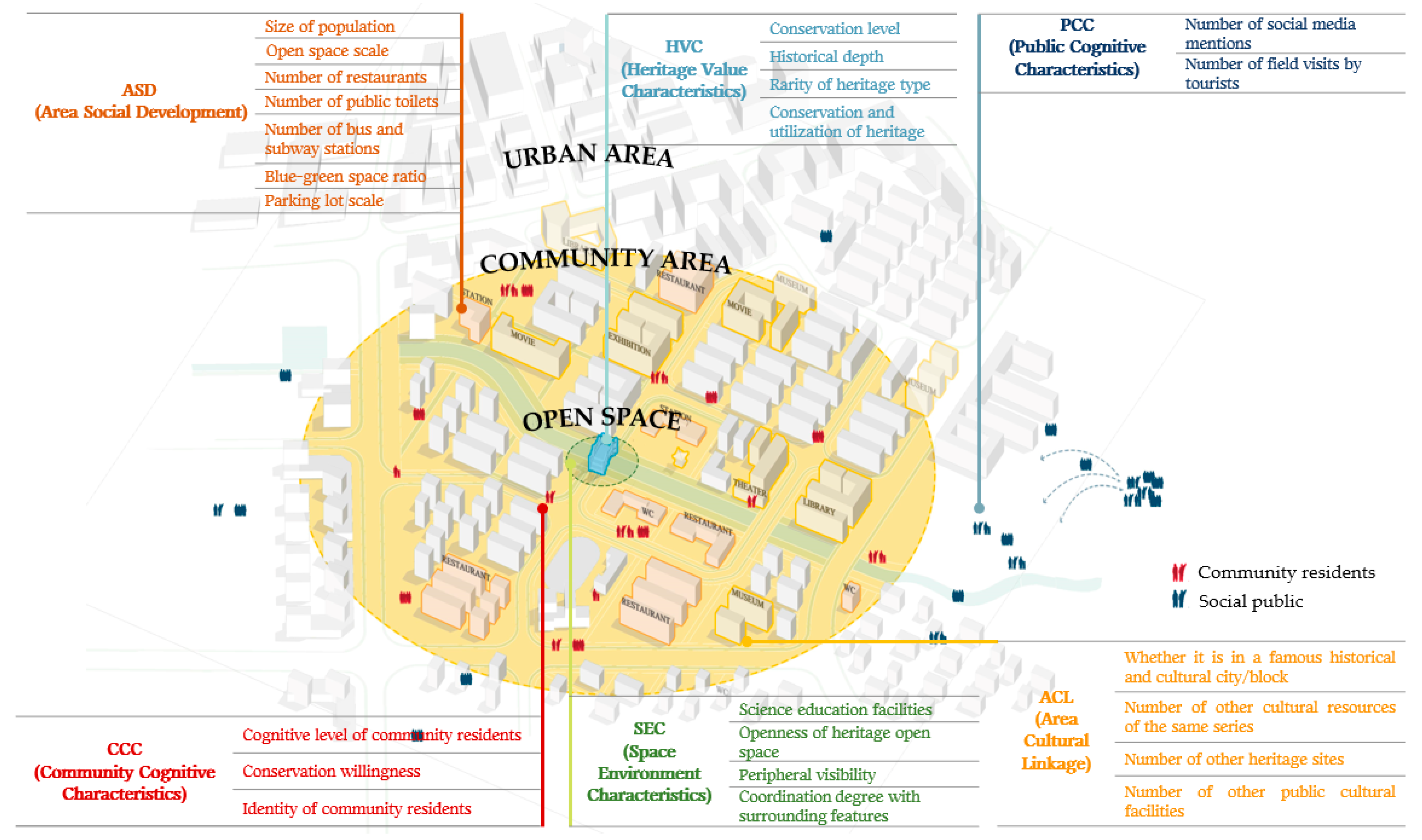
Figure 1. Six dimensions and 24 indicators in HUL assessment framework for SCHS.
Land 14 01513 g001
Figure 2. Location and geographic overview of 30 SCHSs in the Beijing section of the Grand Canal.
Land 14 01513 g002
Figure 3. The assessment results of 30 SCHSs in the Beijing section of the Grand Canal.
Land 14 01513 g003
Figure 4. Comparative analysis of box plots in six dimensions (The numbers represent the SCHSs as shown in Figure 2).
Land 14 01513 g004
Figure 5. Four SCH categories and their characteristics in 6 dimensions.
Land 14 01513 g005
Table 1. Date type and connotation of each indicator.
Dimension IndicatorTypeConnotation
HVCsConservation levelAThe level of conservation (determined according to official documents, e.g., national, provincial, municipal, district, and unranked) reflects the historical value from an official perspective.
Historical depthAThe historical depth of a SCHS is expressed through the dynastic representation of its origins, contextualized within regional/national historical narratives.
Rarity of heritage typeAUniqueness quantified by the inverse proportion of similar heritage types within the research area (e.g., 10% of total sites = rare), indicating historical distinctiveness.
Conservation and utilization of heritageBDual assessment: (1) Physical preservation quality (e.g., material decay rate) and (2) Functional adaptation (e.g., adaptive reuse as cultural venues), focusing on whether heritage has been integrated into new social, economic, or cultural functions, reflecting conservation, transmission, and utilization.
SECsScience education facilitiesBAssessing the capacity and effectiveness of heritage in popularizing heritage-related scientific knowledge and disseminating history and culture, as reflected by the type, size, and number of science education facilities around the site.
Openness of the heritage open spaceBAssessing the extent to which open spaces where heritage is located are accessible to the public and how easily they can be accessed.
Peripheral visibility BFocus on visibility and the visibility of heritage in its open space, reflecting environmental visibility, assessed by the direction of openness, distance of visibility, and level of attraction.
Harmony with surrounding featuresBEvaluate the coherence of the heritage with its open space in terms of landscape (both man–made elements such as buildings and natural elements such as plants and waters), reflecting environmental coherence.
ASDSize of population CStatistics on the total number of people in the community area, reflecting the permanent population of the community.
Open space scaleCStatistics on the total area of open space (including squares, green spaces, and parks) within the community area, reflecting the public environmental quality.
Number of restaurantsCStatistics on the number of food and beverage outlets in the community area reflect the public service capacity.
Number of public toiletsCStatistics on the number of public toilets in the community area reflect the public service capacity.
Number of bus and subway stationsCStatistics on the total number of bus and metro stations in the community area, reflecting public transport accessibility.
Blue-green space scaleCStatistics on the total area of blue (water) and green spaces within the community area, reflecting the ecological environmental quality.
Parking lot scaleCStatistics on the total area of car parks in the community area, reflecting private transport accessibility.
ACLWhether it is in a famous historical and cultural city/blockCInvestigate whether the community area has been included in the official overall conservation zone, reflecting the overall conservation situation of the area.
Number of other heritage sites of the same seriesCStatistics on the number of other cultural heritages belonging to the same heritage series within the community area to reflect the degree of aggregation of a specific historical culture.
Number of other heritage sitesCStatistics on the number of other municipal or higher-level heritage sites within the community area to reflect the overall concentration of historical and cultural resources.
Number of other public cultural facilitiesCStatistics on the number of public cultural facilities (including museums, exhibition halls, cultural squares, cinemas, theatres, and libraries) in the community area, reflecting the potential for connection with contemporary cultural resources.
PCCsNumber of social media mentionsDStatistics on the number of keyword mentions of each SCHS on social media platforms, reflecting the level of social concern.
Number of field visits by touristsDStatistics on the number of historical comments on each SCHS from tourism platforms, reflecting the on-site visits of the public.
CCCsFamiliarity degree of community residentsEConducting field research in the communities to examine the degree of familiarity of the community residents with the SCHSs.
Conservation willingness of community residents EConducting field research in the communities to examine the conservation willingness of the community residents of the SCHSs.
Identity of community residentsEConducting field research in the communities to examine the degree of recommendation of the community residents of the SCHSs.
Table 2. Comparative analysis of the assessment results of 30 SCHS dimension layers based on heritage type, conservation level, and urban district.
Heritage TypeHVCsSECsASDACLPCCsCCCs
Water Gate3.373.813.312.473.433.61
Bridge1.983.722.532.082.852.59
Dock3.183.071.990.992.743.75
Granary2.712.4232.163.172.51
Ancient Site2.612.742.221.661.693.18
Historic Building4.124.42.963.113.293.38
Conservation LevelHVCsSECsASDACLPCCsCCCs
National Conservation3.123.572.662.243.463.16
Municipal Heritage Conservation2.843.082.952.43.122.63
District Heritage Conservation2.533.582.872.232.923.74
Unrated2.022.532.141.541.712.24
DistrictHVCsSECsASDACLPCCsCCCs
Haidian3.464.442.991.893.324.25
Xicheng2.753.893.8144.824.12
Dongcheng3.133.173.393.223.63.06
Chaoyang3.023.153.451.32.372.58
Tongzhou2.563.32.261.692.352.91
The highest score is marked in green, and the lowest score is marked in pink.
Table 3. Pearson’s correlation analysis among different dimensions.
HVCSECASDACLPCCCCC
HVC1
SEC0.532 **1
ASD0.3550.1961
ACL0.2030.2200.506 **1
PCC0.591 **0.537 **0.468 **0.422 *1
CCC0.579 **0.603 **0.2260.3350.489 **1
** indicates significant correlation and * indicates correlation.
Table 4. Pearson’s correlation analysis of 5 indicators of the PCCs and CCCs with the other 19 indicators.
Number of Social Media MentionsNu IUmber of Field Visits by TouristsFamiliarity Degree of Community ResidentsConservation Willingness of Community ResidentsIdentity of Community Residents
Conservation level0.480 **0.504 **0.2570.527 **0.366 *
Historical depth0.1180.1820.0250.1820.271
Rarity of heritage type−0.1520.043−0.0570.0840.222
Conservation and utilization of heritage0.423 *0.567 **0.595 **0.721 **0.655 **
Science education facilities0.465 **0.511 **0.482 **0.597 **0.564 **
The openness of the heritage open space0.3510.2810.3250.512**0.288
Peripheral visibility0.405 *0.449 *0.452 *0.562 **0.461 *
Harmony with surrounding features0.2870.3100.2900.414 *0.368 *
Size of population0.3350.499 **0.1100.2890.262
Open space scale0.2260.406 *0.2250.394 *0.405 *
Number of restaurants0.1100.226−0.188−0.065−0.035
Number of public toilets0.378 *0.2900.0230.0800.153
Number of bus and subway stations0.083−0.051−0.200−0.184−0.171
Blue-green space ratio0.1760.400 *0.2980.433 *0.372 *
Parking lot scale0.2320.3070.3130.1440.110
Whether it is in a famous historical and cultural city/block0.456 *0.413 *0.366 *0.484 **0.471 **
Number of other heritage sites of the same series−0.312−0.2980.004−0.051−0.115
Number of other heritage sites0.383 *0.336−0.1170.1800.139
Number of other public cultural facilities0.429 *0.3410.0640.2740.250
** indicates significant correlation and * indicates correlation.
Disclaimer/Publisher’s Note: The statements, opinions and data contained in all publications are solely those of the individual author(s) and contributor(s) and not of MDPI and/or the editor(s). MDPI and/or the editor(s) disclaim responsibility for any injury to people or property resulting from any ideas, methods, instructions or products referred to in the content.