Abstract
In the context of increasing climate variability and flood risk, this study explores how long-standing agricultural practices in the Hunter Valley, New South Wales, Australia, have fostered flood resilience through the integration of local agro-environmental knowledge and geomorphologic conditions. Employing a morpho-typological framework, the research identifies three flood adaptation landscape types (FALTs)—rolling hills, foot slopes, and flood plains—each reflecting distinct interactions between landform, soil, biodiversity, hydrology, and viticultural management. Through geospatial analysis, field surveys, and interviews with local farmers, the study reveals how adaptive strategies—ranging from flood avoidance to attenuation and acceptance—have evolved in response to site-specific hydrological and ecologic dynamics. These strategies demonstrate a form of ‘sponge landscape’ design, where agricultural systems are co-shaped with natural processes to enhance systemic resilience and long-term productivity. The findings underscore the value of preserving biocultural legacies and suggest that spatially explicit, context-based approaches to flood adaptation can inform sustainable landscape planning and climate resilience strategies in other rural regions. The FALT framework offers a replicable methodology for identifying flood adaptation patterns across diverse agricultural systems in Australia, supporting proactive land use planning and nature-based solutions. This research contributes to the discourse on climate adaptation by bridging traditional environmental knowledge with contemporary planning frameworks, offering practical insights for policy, landscape management, and rural development.
1. Introduction
1.1. Floods and Agricultural Landscapes
Agricultural landscapes are experiencing a drier climate with rainfall occurring less frequently but in more intense and severe flooding events when it does [1]. Recent research shows that extreme rainfall intensity will increase significantly—well beyond the expected 7% per degree of global warming [2]. The changes already impact food production, water security, biodiversity conservation, public recreation, and health [3].
Agriculture strongly influences the hydrology of rural ecosystems. In areas of intensive farming, reduced surface permeability increases runoff and waterlogging, worsening flood impacts [4]. Flooding in large-scale industrial farms can also affect downstream urban and peri-urban areas.
Historically, sustainable farming has played a key role in managing stormwater and flood risk [5,6]. Moderate agricultural disturbance can enhance landscape resilience [7]. Low-impact practices create positive feedback loops between nature and agriculture [8], supporting more effective and sustainable flood management [9,10]. This aligns with international goals, such as the UN Sustainable Development Goal No. 2 on sustainable agriculture. Yet, despite growing awareness of the interdependence between natural processes and farming, flood adaptation in agriculture remains under-researched [11,12].
Low-impact farming and land management increase rural regions’ adaptive capacity and reduce the flood risk [13]. These practices support nature-based solutions that use the landscape’s natural permeability to reduce waterlogging—like the sponge-like flood management approach developed in China [14,15,16]. Applying the sponge concept to agriculture helps explain flooding in rural areas [17,18]. Techniques that improve soil moisture retention, restore topsoil organic layers, and manage biodiversity make farms more resilient to climate extremes [19]. They also provide ecosystem services, such as pollination, enhanced soil fertility, and pest and erosion control [20].
Many of these techniques have been long been used by Australian farmers, especially in regions where nature–agriculture legacies support flooding resilience. These are examples of ‘knowledge-intensive’ agriculture [21], where floods pose both risks and benefits [22]. For example, in Langhorne Creek, SA, ‘recession agriculture’ [23] uses seasonal flooding to enhance soil fertility [22]. In McLaren Vale (SA), farmers manage riparian biodiversity and stormwater to reduce flood and drought risks. These site-specific practices reflect the landscape’s geophysical features—such as topography, hydrology, land cover and permeability, microclimate, and biodiversity—and have sustained productivity over time [24,25].
Similar examples can be found in SA, NSW, WA, and Victoria, where positive feedback loops between natural processes and farming have increased local flood resilience [24]. While this environmental knowledge has been explored from anthropological, historical, and rural productivity perspectives [22,26,27], it has not yet been examined spatially and ecologically within the landscape system. Stormwater management practices, flood responses, and landscape configurations that support agriculture remain poorly understood [24,28]. Recognizing the nature–agriculture legacy embedded in long-lasting landscape forms could offer a model for building resilient rural systems and adapting to future threats, including floods.
Although nature-based and sponge-like approaches to agriculture have been widely advocated [17], a full understanding of how farmers already apply these techniques to shape the landscape and improve crop outcomes is still lacking. Most importantly, past and present flood responses in knowledge-intensive rural regions—those capable of informing broader adaptation strategies—have yet to be systematically studied.
1.2. Aims and Paper’s Overview
To address the gap, the study examines the natural and agricultural features of a knowledge-intensive rural region in the Hunter Valley in NSW. Like other viticultural landscapes, the Hunter Valley faces increasing flood risk due to rapid environmental change and external pressures.
The research hypothesizes that the farmers’ local environmental knowledge stems from long-term interactions with the landscape’s geomorphological and ecological systems. The study aims to:
- i.
- identify where and how these interactions have fostered flood resilience over time, and
- ii.
- detect recurrent patterns of flood adaptation by analyzing the viticultural landscape.
The spatial and ecological interplay between natural processes and human activity reveals three distinct flood management strategies, or flood adaptation landscape types (FALTs). These strategies—embedded in specific landforms, vegetation patterns, and microclimates—have supported rural flood resilience across generations. Understanding these spatial forms of resilience can inform planning decisions tailored to similar conditions in other less resilient regions [24].
The paper is structured in three sections:
Section 1 introduces the theoretical framework, based on a morpho-typological approach, and outlines the integrated methodology combining cultural, spatial, and ecological analysis.
Section 2 presents findings from the geospatial analysis of the Hunter Valley and discusses historical and current land management practices that support flood adaptation.
Section 3 reflects on the lessons learned from identifying FALTs, exploring their implications for flood management, future research, and practical applications.
2. Theoretical Framework, Materials, and Methods
2.1. A Morpho-Typological Approach to Identify Flood Adaptation Landscape Types (FALTs)
A morpho-typological approach investigates urban and rural morphology by examining buildings, blocks, and plots in relation to orographic, environmental, and socio-historic contexts [29]. It combines spatial morphology—focused on physical structures—with typological classification, which traces how settlements and landscapes evolve over time. This framework has deep roots in early 20th century European geographical traditions (e.g., Geddes, Conzen, and Muratori) and landscape ecology. Although the geographic determinism of 1960s landscape ecology [30] has declined, the morpho-typological approach has seen renewed interest, especially in relation to socio-ecologic systems and biocultural diversity frameworks [11].
Urban and rural morphology schools in Italy and England extensively explored how geographic (orographic and hydrographic) and geophysical (geologic and tectonic) systems influence human developments [31,32,33]. The analytical tools developed in this tradition remain relevant for understanding how human habitats evolve and for guiding sustainable landscape management and conservation.
A key concept in this approach is the idea of a biunivocal correspondence of natural and human systems. This perspective allows morphological analysis to extend beyond urban areas, incorporating spatial and ecologic processes in rural, agricultural, and peri-urban regions [33,34].
In morpho-typological research, landscape configurations shaped by similar orographic and ecological conditions are known as territorial types [30] (p. 49). These types emerge when consistent geographic features produce distinctive spatial arrangements or landforms through specific land management practices. Territorial types are defined by their functional, formal, and structural characteristics, reflecting how human settlements adapt to local environmental conditions over time [30] (p. 49).
Four main territorial types are identified based on geographic classification, namely, Ridges, Mid-slope or Hillside, Valley Floor, and Plains types [30,35,36].
Ridges are characterized by routes and rural land parcels aligned with the water divides or ridgelines. These are among the oldest forms of human landscape organization, typically found between valley systems.
Mid-slopes or Hillsides are characterized by routes and parcels that follow contour lines along mountain slopes. A sub-type, the Foothill, follows the lowest contour line adjacent to the valley floor.
Valley Floor includes routes and parcels located in flood plains, flats, or valley floors parallel to streams and rivers.
For Plains, unlike other types, routes and parcel orientation here is not influenced by landform. Instead, layouts follow geometric patterns across the terrain.
For this study, these territorial classifications are referred to as landscape types, used to describe how current agricultural forms interact with pre-existing orographic and ecologic configurations to support flood resilience [37].
2.2. Methods and Materials
To investigate the relationship between landscape geomorphology and flood adaptation in viticultural systems, this study employed a multi-method approach integrating spatial, ecological, and cultural dimensions (Scheme 1). The methodology was structured into three sequential phases:
- Phase 1: Data Collection
- Desktop research: Compilation of geospatial datasets, including high-resolution aerial imagery (ADS40/50GSD) and the Soil and Land Resources Report 2018 that identifies over 460 soil and land types in the Hunter Valley, detailing key DEM-based indicators, such as landforms, land cover, geomorphic processes, soil characteristics, and erosion patterns, to support landscape-scale environmental analysis.
- Field surveys: On-site landscape appraisal and photographic documentation of historically resilient vineyards to identify adaptation patterns.
- Field interviews: Ten interviews with local farmers during field surveys gathered insights on flood adaptation practices and historical land use. Interviews were semi-structured and qualitative, aiming for depth rather than statistical generalization. The interviews were conducted using a ‘walk and talk’ method [24,38] and consisted of a rapid rural appraisal and conversations to generate socio-ecological interpretations and narratives on landscapes.
- Phase 2: Typology Development
- Identification of long-standing vineyards using the Hunter Valley Heritage Vineyards Register [39], which maps the continuity of early vineyards and documents oral knowledge about vine genomes first imported from Europe. This heritage, passed down through generations of farmers, represents a valuable form of intangible environmental knowledge that contributes to flood resilience in the region.
- Classification of landscape types based on geomorphological features and agricultural practices.
- Cross-referencing of soil, slope, aspect, and hydrological data with vineyard block orientation and crop types.
- Phase 3: Triangulation and Analysis
- Integration of qualitative data (interviews) with quantitative geospatial indicators.
- GIS sieve mapping correlates flood responses with landscape types.
- Validation of flood adaptation landscape types (FALTs) through spatial and ecological consistency.

Scheme 1.
Methodological workflow.
2.3. The Case Study—The Hunter Valley Geographical Indications (GIs)
The Lower Hunter Valley is a major wine-producing region in NSW, Australia, and a prominent example of knowledge-intensive agriculture, known for its scenic landscapes and premium food production [40]. A fine-grained landscape mosaic is the result of well localized and utilized physiotopes by viticulture, forestry, and pastoralism [41]. The oldest surviving vineyards in Australia were planted here in the early 1800s using rootstocks imported from Europe, prior to the grape phylloxera crisis [26,42]. These vineyards contain vine genomes that are unique to Australia and mark the birth of the national wine industry, which has significantly shaped the region’s history and socio-economic development. The relatively recent establishment of agriculture in the area offers a unique opportunity to retrace landscape evolution and assess its continuity and resilience over time (Figure 1).
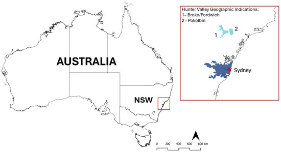
Figure 1.
The Hunter Valley Geographic Indications of Broke/Fordwich and Pokolbin in New South Wales, Australia.
The study focuses on two wine Geographical Indication (GI) areas in the Lower Hunter Valley—Pokolbin and Broke/Fordwich. These regions are among the most resilient agricultural regions in Australia, with vineyards that have remained productive since their establishment [26,40,42]. The landscape character of both GIs is defined by the Brokenback Ridge, a prominent geological feature stretching over 30 km and serving as a visually unifying landmark across the viticultural region. A close-knit community of viticulturalists, sustained agriculture for over two centuries, and active biodiversity management, have all contributed to the landscape’s resilience. The complex interplay between natural and agricultural systems has enabled the region to recover quickly from climate-related disturbances, such as flooding [27]. For example, the landscape demonstrated strong systemic resilience following the July 2022 Wollombi Brook flood, when water levels exceeded the 100-year record and submerged much of the Broke-Fordwich GI vineyards (Figure 2).
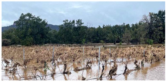
Figure 2.
The Wollombi Brook flooding in Broke/Fordwich GI, 2 August 2022. Source: https://www.wineselectors.com.au/selector-magazine/wine/a-flood-of-support-for-hunter-wine-country (accessed on 1 June 2025).
3. Landscape Types and Flood Resilience
3.1. Landscape Continuity and Adaptive Capacity
Geospatial analysis of the Lower Hunter Valley catchment reveals a complex interplay between orographic, ecological, cultural, and agricultural dimensions. Local land uses—farming, grazing, and forestry—have long been integrated with biodiversity conservation and native vegetation management [43]. Nature-based solutions are widely applied to support sustainable agriculture, mitigate climate impacts, and improve land stewardship. These include agroforestry, organic farming, integrated pest management, habitat restoration, crop diversification, soil conservation, and water management.
The Hunter Valley Heritage Vineyards Register database [39], supported by field interviews with farmers, identifies three key areas within the Pokolbin and Broke/Fordwich GI regions where the oldest and most resilient vineyards are located. Most of these vineyards were planted over a century ago and are clustered around Pokolbin, Hermitage Road, and Fordwich (Figure 3). In these areas, generations of farmers have shaped the viticultural landscape through a process of trial and error [27]. This iterative approach has gradually enhanced environmental and flood resilience, as evidenced by the continuity of land use and land cover since the early days of viticulture [24].
To assess vineyard permanence, this study applied UNESCO’s criteria of earliness, continuity, and integrity [44]. Earliness refers to the presence of heritage vineyards and original vine biomes dating back to early colonial agriculture. Continuity denotes uninterrupted land use since establishment. Integrity indicates that the landscape retains its original characteristics. Together, these criteria reflect the resilience of the viticultural landscape.

Figure 3.
Locations of oldest continuing vineyard clusters [39]. A—Fordwich, B—Hermitage Rd., and C—Pokolbin), overlaid on the Soil and Land Resources of the Hunter Region [45] highlight the three main geomorphic processes (purple—Erosional; blue—Alluvial; light brown—Transferral).
The long-term persistence of vineyards in the same locations suggests a positive relationship between land management practices and local geomorphology and microclimate. Field interviews confirm that knowledge-intensive agriculture has supported flood and drought adaptation in these three areas. One respondent stated that:
“It’s not coincidental that old vine plantings are all concentrated there. It’s not coincidental that there’s a great concentration of old vine material, that’s resilience and it’s not an accident.”
Another noted that:
“I think that idea comes around through survival rather than a predetermined plan. It reveals itself over time, trials and errors. I think everything was basically based on experiments. We’ve only been here for less than 200 years. Those vineyards have endured because they produce good crop that pays. If it doesn’t pay, it gets ripped out.”
These interviews highlight how each of the three areas is shaped by distinct geomorphic processes, each corresponding to a specific flood adaptation strategy:
- Vineyards are placed on ridges or hill slopes to avoid flood-prone areas and benefit from high-quality soils ideal for premium red wines. One farmer explained:
“Alluvial soils are not so suited to red, and the red will probably be, arguably, more on the erosional soils of the hills. So, a bit more elevation, a bit hotter, a bit dryer.”
- 2.
- Vineyards are located on gently sloping terrain with free-draining red–brown volcanic soils that retain moisture—ideal for red wine production. A respondent noted:
“The topography helps draining flood water, while the volcanic soil absorbs moisture quickly and releases it slowly, an important bonus for this high-latitude region.”
- 3.
- Vineyards are intentionally placed in low-lying alluvial flats with fast-draining sandy soils, where periodic flooding enhances soil fertility—ideal for white wines. As one farmer described:
“Alluvial creek beds are really suited to white varieties where soil is free draining, thus flood recedes relatively quickly. The high groundwater level is conducive to the vines… some of these vines are 100 years old and have been dry grown as the flood replenishes the profile.”
3.2. Landscape Indicators and Flood Adaptation Landscape Types (FALTs)
Understanding the relationships between geophysical features of the landscapes and human-driven landscape changes [35] supports the identification of flood adaptation landscape types (FALTs) in the Hunter Valley.
In addition to the qualitative data from farmers’ interviews and the Hunter Valley Heritage Vineyards Register database [39], the study examined several key factors influencing flood adaptation. These were grouped in three main categories of indicators, cross-referenced to identify landscape types with similar flood responses. These include:
- Natural processes—geomorphology and land cover
- Anthropogenic processes—agricultural land management practices
- Flood adaptive approaches—stormwater management.
Geomorphology indicators describe the physical features and processes shaping the landscape, including landforms, soil composition, hydrology, and erosion. The study draws on the 2018 OEH report [45], which defines dominant geomorphic processes and includes variables such as landform, altitude, slope gradient, aspect, and soil type. Soil permeability and water retention capacity were also assessed to understand drainage and flood absorption potential.
Agricultural land management indicators reflect the practices that have supported viticulture in the region since its establishment. These include precision agriculture techniques [46], such as selecting grape varieties based on soil type, and the orientation, shape, and aspect of vineyard blocks and vine rows in relation to topography.
Flood and storm water management indicators capture local flood patterns and farmer responses. These include historical flood events, risk mitigation strategies, stormwater infrastructure, and biodiversity management practices.
Cross-referencing these indicators confirmed that the three study sites not only show long-standing land use but also distinct flood adaptation strategies shaped by geomorphology. These findings support the identification of three main FALTs: Rolling Hills, Foot Slopes, and Flood Plains. The classification is based on terrain types defined in the soil landscape and facet mapping of the Hunter and Central Coast Regional Environmental Management Strategy [47] (p. 12).
3.3. Flood Adaptation Landscape Types
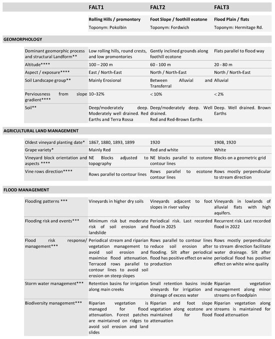
Rolling Hills (promontory) FALT1—This type features low hills (up to 250 m above sea level) extending from the Brokenback Ridge into the Hunter Valley plains (Figure 4). The terrain is shaped by erosional processes, with slopes ranging from 10 to 32% and moderately well-drained red earths and Terra Rossa soils. These iron-rich soils offer excellent drainage and contribute to the quality of red wines produced here [45].
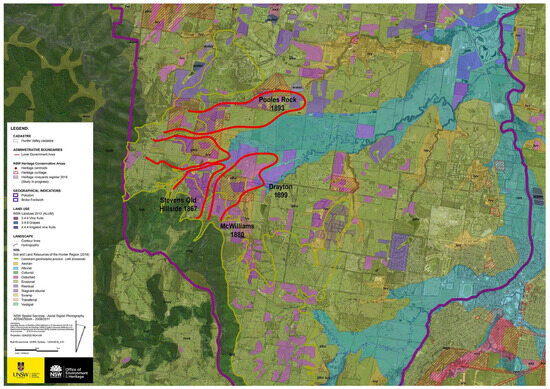
Figure 4.
FALT1 Rolling Hills—the system of ridges and promontories (in red).
Vineyards are located on gentle slopes with a northeast aspect to avoid prevailing southwesterly winds. The oldest vineyards date back to the late 1800s. To reduce soil erosion, blocks follow the contours of the promontories east of the Brokenback Ridge (Figure 5). Drought-resistant grape varieties are common, suited to rainfed cropping and red wine production.
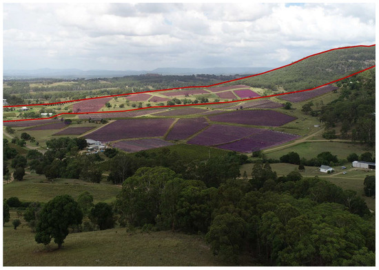
Figure 5.
FALT1 Rolling Hills, view—the system of ridges and promontories (in red). Vineyard blocks on slopes with mainly northeast-facing aspects.
Flood risk is low due to the elevated terrain, though erosion and landslides remain concerns. No flood events have been recorded in these high vineyards. Riparian vegetation is maintained to slow water flow and prevent erosion. Farmers also use water retention dams along creeks for irrigation.
Foot Slope (foothill ecotone) FALT2—This type occurs on gently sloping grounds at the base of mountain ridges, above creek lines, with elevations up to 100 m and slope gradients lower than 10% (Figure 6). Soils are shaped by transferral processes, consisting of deep deposits eroded from upslope areas. Well-drained red–brown earths support both red and white wine production [45].
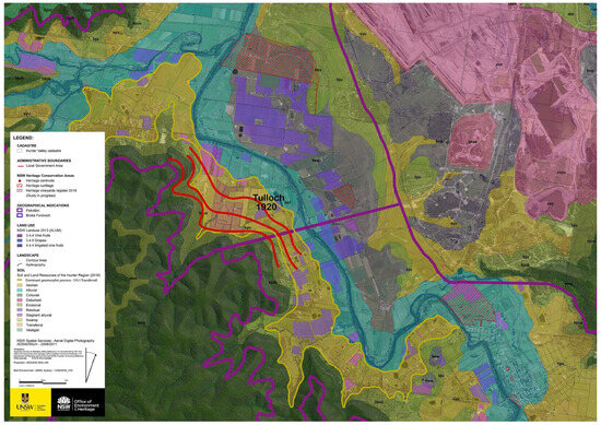
Figure 6.
FALT2 Foot Slopes—the mountain foothill and the ecotone system (contour lines in red).
Vineyards are primarily located on gently inclined plains along the lower foothill contours, with a northeast aspect to avoid prevailing southwesterly winds and following the ecotone line between hill slopes and streams. The oldest continuing vineyards in this area were established in the early 1900s. Vineyard blocks are aligned with the contours of the gentle slopes (Figure 7). Vine rows follow the foothill, running parallel to contour lines and along the ecotone. Vine varieties in this zone support mainly red wines, with occasional white varieties.
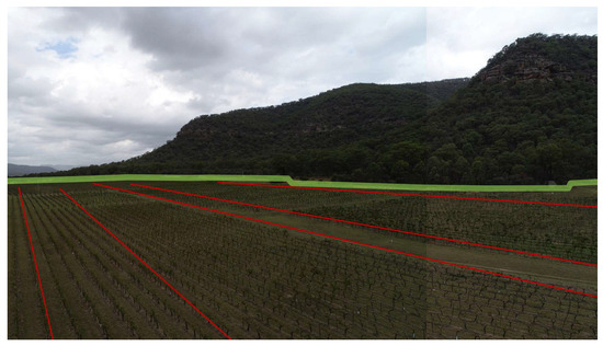
Figure 7.
FALT2 Foot Slopes, view—the foothill and the ecotone system. Vineyard blocks follow contour lines of gentle slopes (in red) with northeast-facing aspects.
Flood risk is considered moderate and is managed by positioning vineyards on the highest possible ground adjacent to foot slopes and away from stream channels. The last recorded flood event that submerged vines occurred in 2025. Rows aligned parallel to contours help reduce soil erosion during receding floodwaters. The topography and well-drained soils allow for short, periodic flooding, with water receding quickly and leaving behind sediment that positively affects soil fertility. To minimize flood risk, periodic riparian vegetation maintenance is carried out along streams and the ecotone to prevent erosion and enhance flood attenuation. Small-scale water retention basins are also located within vineyards to manage excess water and support irrigation.
Flood Plain (flats) FALT3—The flood plain landscape type is characterized by alluvial plains with a maximum altitude of 100 m above sea level, enclosed by the hydrographic system of minor tributaries (creeks) of the Hunter River (Figure 8). Geomorphic processes here are predominantly alluvial, occurring on slope gradients lower than 2%. Soils formed by fine silt deposition along rivers and streams are classified as well-drained brown earths [45].
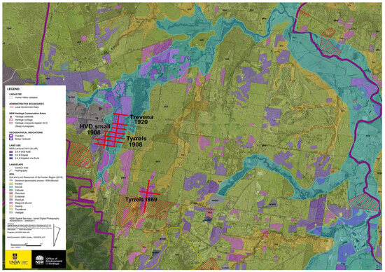
Figure 8.
FALT3 Flood Plain—the alluvial plain and hydrographic system. Vineyard blocks have a geometric configuration (in red).
Vineyards are located on flat plains with geometric configurations and northeastern aspects. Vineyard blocks are designed for easy access to water (Figure 9), with vine rows mostly oriented perpendicular to the stream direction to facilitate effective water drainage. The oldest continuing vineyards in this area were established in the first decade of the 1900s. Vine varieties here primarily support white wine production.
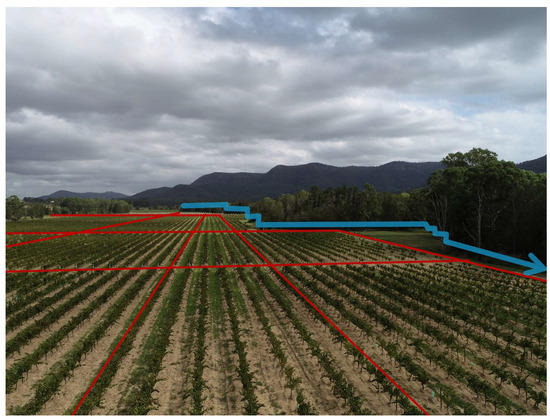
Figure 9.
FALT3 Flood Plain, view—the alluvial plain and hydrographic system. Vineyard blocks have a geometric configuration (in red).
These vineyards are situated in lowlands with high aquifers and fast-draining soils, where recurrent flooding is common. Flooding has beneficial effects on grape production, and flood-deposited silt is valued for its positive impact on wine quality. The most recent flood event was recorded in 2022. To reduce flood risk, regular stream and riparian vegetation maintenance is conducted to enhance flood attenuation and protect vineyard infrastructure.
4. Discussion
The relatively young viticultural region of the Hunter Valley in NSW offers a valuable opportunity to examine landscape transformation over the past 150 years and to trace how local agriculture has adapted to flooding. Analysis of the region’s natural and agricultural features reveals a continuing positive relationship between geographic conditions and farming practices (Scheme 2). Understanding these relationships—through the proposed classification of flood adaptation landscape types (FALTs)—has important implications for guiding sustainable and effective flood management.
Scheme 2.
Summary of flood adaptation landscape types’ (FALTs) characteristics. * Heritage Vineyards Register Study, 2019 [39]. ** Soil and land resources study of the Hunter Region [45]. *** Farmers’ interviews. **** Geospatial analysis and GIS remote sensing of high-resolution aerial imagery.
- Key insights from the Hunter Valley landscape include:
- Local farmers’ approaches to flood management are highly context specific.
- Agricultural practices are based on refined knowledge of crop selection, land and water management, and biodiversity management, tailored to specific orographic and hydrographic conditions [42].
- A trial-and-error approach has shaped decisions over time, particularly in selecting crop locations and varieties.
- Farmers’ environmental knowledge continues to evolve, adapting to increased climate awareness, improved techniques, and changing conditions [40].
- Different responses to water excess and scarcity can be identified by linking geospatial landscape features with long-standing agricultural practices.
Farmers with a deep understanding of their local environment make informed decisions about crop placement and flood management to enhance productivity. Three areas in the Hunter Valley, home to the most resilient vineyards, illustrate how distinct geomorphologies have led to three different flood adaptation strategies:
Localization (FALT1—Rolling Hills). This strategy avoids flood-prone areas by selecting elevated farmland. Farmers benefit from well-drained soils and use drought-resistant vine varieties. Native vegetation is actively managed to reduce erosion and landslide risks.
Attenuation (FALT2—Foot Slope). This approach accepts occasional flooding in transitional zones between valley flats and hills. Farmers take advantage of fertile soils and water access, using erosion control and flood attenuation techniques, such as riparian vegetation and small retention basins.
Safe to flood (FALT3—Flood Plains). This strategy places vineyards in flood-prone areas, turning risk into opportunity. Floods enhance soil fertility, and vine varieties are selected to tolerate excess water. Farmers manage vegetation and drainage to support flood attenuation.
These approaches illustrate how the region’s adaptative capacity has progressively strengthened in response to flooding and other environmental challenges. Forms of ‘sponge landscape’ design exist, where agricultural systems are co-shaped along with natural processes to enhance systemic resilience.
4.1. Future Research Opportunities
At a research level, documenting local landscape management, across geospatial, ecological, and cultural dimensions, required a specific, multi-layered methodology tailored to the region’s historical and environmental context. The integration of diverse methods, including field surveys, remote sensing, farmers’ interviews, and geospatial analysis, lays the foundation for broader research beyond this research preliminary correlations. Expanding this methodology nationally and globally could uncover valuable lessons from the wide range of locally developed responses to Australia’s extreme microclimatic conditions.
This study presents a qualitative and geospatial framework for identifying and analyzing flood adaptation landscape typologies (FALTs) in rural settings. By combining spatial narratives, typological mapping, and landscape interpretation, the research offers a grounded understanding of how nature-based solutions can enhance flood resilience. While the approach is primarily qualitative, it lays the foundation for future integration with hydrodynamic modeling and engineering validation. Linking this framework with quantitative performance metrics could enable a more comprehensive assessment of FALT performance under varying climatic and hydrological conditions. Moreover, future interdisciplinary collaborations combining a typological approach, machine learning, and climate projections would strengthen both the empirical robustness and policy relevance of landscape-based flood management strategies.
4.2. Practical Applicability and Generalizability of FALT Framework
The FALT framework and sponge landscape concept offer a scalable model for flood adaptation that can be applied across diverse agricultural systems in Australia. By linking geomorphological features with site-specific agricultural practices, the classification system enables planners and land managers to identify context-sensitive strategies for flood resilience. In regions such as the Murray-Darling Basin or the Barossa Valley, where viticulture and other forms of intensive agriculture face increasing climate pressures [48], the FALT typologies can guide adaptive land use planning, inform zoning regulations, and support nature-based solutions tailored to local soil, slope, and hydrological conditions. Moreover, the framework’s emphasis on biocultural legacies and farmer knowledge ensures its relevance in areas with strong agricultural heritage, promoting sustainable practices that align with both environmental and socio-economic goals.
The generalizability of the FALT framework lies in its ability to translate complex landscape dynamics into actionable planning categories. For example, in flood-prone areas of Northern Queensland or Tasmania, where horticulture and grazing dominate, the typological approach could be adopted to classify terrain into flood avoidance, attenuation, and safe-to-flood zones. This would allow for the strategic placement of crops, infrastructure, and biodiversity corridors in ways that enhance resilience while maintaining productivity. The framework also supports cross-sectoral collaboration, enabling integration with water resource management, biodiversity conservation, and rural development policies.
Most importantly, the FALT framework provides a replicable methodology for identifying and leveraging local adaptation strategies in other regions. Its multi-method approach—combining geospatial analysis, field surveys, and stakeholder interviews—can be tailored to different agricultural contexts, including dryland farming in Western Australia or mixed cropping systems in Victoria. By capturing the spatial logic of flood adaptation embedded in long-standing agricultural practices, the framework helps bridge the gap between traditional knowledge and contemporary climate adaptation planning. This makes it a valuable tool for regional councils, catchment authorities, and agricultural extension services seeking to build climate-resilient rural landscapes.
4.3. Policy Implications and Planning Recommendations for Flood Adaptation
The identification of FALTs in the Hunter Valley underscores the need for agricultural policy frameworks that recognize and support landscape-specific flood adaptation strategies. Current national policies and funding often emphasize post-disaster recovery rather than resilience building.
Integrating the FALT framework into regional planning instruments could shift the focus toward anticipatory adaptation in collaboration with farmers, encouraging investment in nature-based solutions, such as riparian vegetation management, soil conservation, and agroecological diversification. Furthermore, the recognition of biocultural heritage in flood-prone agricultural regions could inform heritage conservation policies, ensuring that traditional knowledge systems are preserved and leveraged for climate adaptation.
From a planning perspective, the sponge landscape concept advocates for a paradigm shift in rural land governance. Rather than treating flood-prone areas as liabilities, planners can reframe them as assets by promoting “safe-to-flood” agricultural zones and designing multifunctional landscapes that integrate flood attenuation with productive land use. Local councils and catchment management authorities should incorporate FALT typologies into strategic land use plans, enabling targeted interventions, such as zoning overlays, incentive schemes for biodiversity stewardship, and infrastructure investments that align with natural hydrological regimes. These recommendations align with broader themes in Australian flood mitigation policy, including the National Disaster Risk Reduction Framework [49] and the call for climate-resilient agriculture.
In addition, the FALT framework could inform updates to the National Landcare Program [50] and the Future Drought Fund [51] by providing spatially explicit criteria for funding allocation and project prioritization. For instance, regions demonstrating high landscape continuity and adaptive capacity could be targeted for conservation easements, while areas with low resilience could benefit from restoration initiatives guided by FALT-informed typologies. This would ensure that public investment is directed toward resilience-targeted interventions with proven ecological and socio-economic benefits, enhancing the overall effectiveness of national adaptation strategies.
Finally, the integration of FALT into planning and policy frameworks supports a shift toward bottom-up landscape-based governance, where decisions are made with a holistic understanding of local terrain, ecology, and cultural heritage. This approach aligns with international best practices in climate adaptation and disaster risk reduction, such as the IPCC’s emphasis on locally grounded solutions [52]. By embedding the FALT framework into planning systems, Australia can foster more resilient agricultural landscapes that are better equipped to face future climate extremes, while also preserving the cultural and ecological richness of its rural regions.
5. Conclusions
This study has demonstrated that long-standing agricultural practices in the Hunter Valley, NSW, have fostered flood resilience through a nuanced interplay between geomorphology, land management, and local environmental knowledge.
By identifying and classifying three distinct flood adaptation landscape types (FALTs), the research provides a replicable framework for understanding how rural landscapes can be co-shaped with natural processes to enhance systemic resilience. The concept of the sponge landscape, as articulated here, captures this dynamic relationship and offers a powerful lens for rethinking flood adaptation in agricultural systems. The FALT framework is not only contextually grounded but also broadly applicable across diverse Australian agricultural regions. Its integration of spatial, ecological, and cultural dimensions allows for the identification of site-specific adaptation strategies that can inform planning in other viticultural zones, mixed farming systems, and flood-prone rural areas.
By translating complex landscape dynamics into actionable typologies, the framework supports more targeted and effective adaptation planning, particularly in regions facing increasing climate variability and precipitation extremes. Importantly, this research underscores the value of preserving and leveraging biocultural legacies in climate adaptation. The adaptation strategies observed in the Hunter Valley are not isolated practices but part of a broader knowledge system that has evolved through generations of trial, observation, and refinement. Recognizing this local knowledge through planning instruments, funding mechanisms, and policy frameworks can significantly enhance the resilience of rural communities and ecosystems.
In the frame of current environmental change, the systematic application of sponge landscape principles offers a low-impact, high-return strategy for managing flood risk. Rather than relying solely on engineered solutions, this approach advocates for working with the landscape, accepting a degree of mutual dependency between natural and agricultural systems. Embedding FALT-informed strategies into regional and national planning frameworks can help shift the focus from reactive to proactive adaptation, ensuring that Australia’s agricultural landscapes remain productive, biodiverse, and resilient in the face of future environmental challenges.
Funding
This research was partially funded by the Hunter Valley Wine and Tourism Association, grant number RG190355, and the APC was funded by the School of Built Environment, UNSW Sydney.
Data Availability Statement
The original contributions presented in the study are included in the article, further inquiries can be directed at the corresponding author.
Acknowledgments
The author gratefully acknowledges the support of the School of the Built Environment, UNSW Sydney. Special thanks to the Hunter Valley Wine and Tourism Association for providing data and logistic support to the research. The author also acknowledges the late Kongjian Yu for his influence on this research, stemming from discussions held during earlier collaborations.
Conflicts of Interest
The author declares no conflict of interest.
Abbreviations
The following abbreviations are used in this manuscript:
| FALT | Flood Adaptation Landscape Types |
| GI | Geographic Indication |
| HVWTA | Hunter Valley Wine and Tourism Association |
| HVHVR | Hunter Valley Heritage Vineyards Register |
| OEH | Office of Environment and Heritage, NSW |
| UNESCO | United Nations Educational, Scientific and Cultural Organization |
References
- CCA. The Great Deluge: Australia’s New Era of Unnatural Disasters; Climate Council of Australia: Melbourne, Australia, 2022. [Google Scholar]
- Wasko, C.; Westra, S.; Nathan, R.; Pepler, A.; Raupach, T.H.; Dowdy, A.; Johnson, F.; Ho, M.; McInnes, K.L.; Jakob, D.; et al. A systematic review of climate change science relevant to Australian design flood estimation. Hydrol. Earth Syst. Sci. 2024, 28, 1251–1285. [Google Scholar] [CrossRef]
- ABS. Australia Bureau of Statistics. Impacts of Flooding in December Quarter 2022. 2023. Available online: https://www.abs.gov.au/articles/impacts-flooding-december-quarter-2022 (accessed on 1 June 2025).
- Piana, P.; Faccini, F.; Luino, F.; Paliaga, G.; Sacchini, A.; Watkins, C. Geomorphological Landscape Research and Flood Management in a Heavily Modified Tyrrhenian Catchment. Sustainability 2019, 11, 4594. [Google Scholar] [CrossRef]
- Laureano, P. The Water Atlas; Laia Libros, S.L.: Padova, Spain, 2005. [Google Scholar]
- Palazzo, E. Il Paesaggio Nel Progetto Urbanistico (Landscape in Urban Design); EdA, Il Prato: Saonara, Italy, 2010. [Google Scholar]
- Marull, J.; Tello, E.; Fullana, N.; Murray, I.; Jover, G.; Font, C.; Coll, F.; Domene, E.; Leoni, V.; Decolli, T. Long-term bio-cultural heritage: Exploring the intermediate disturbance hypothesis in agro-ecological landscapes. Biodivers. Conserv. 2015, 24, 3217–3251. [Google Scholar] [CrossRef]
- Kazakov, L.K. Landscape Ecology Culture and Some Principles of Sustainable Nature Use. In Current Trends in Landscape Research. Innovations in Landscape Research; Mueller, L., Eulenstein, F., Eds.; Springer: Berlin/Heidelberg, Germany, 2019. [Google Scholar]
- Ellis, E.C. The Anthropocene condition: Evolving through social–ecological transformations. Philos. Trans. R. Soc. 2023, B379, 20220255. [Google Scholar] [CrossRef] [PubMed]
- UN. Transforming Our World: The 2030 Agenda for Sustainable Development, SDGs. 2015. Available online: https://sdgs.un.org/#goal_section (accessed on 1 June 2025).
- UNESCO/CBD. Florence Declaration on the Links between Biological and Cultural Diversity. 2014. Available online: https://www.cbd.int/portals/culturaldiversity/docs/21040410-declaration-florence-en.pdf (accessed on 1 June 2025).
- Penning, E.; Peñailillo Burgos, R.; Mens, M.; Dahm, R.; de Bruijn, K. Nature-based solutions for floods AND droughts AND biodiversity: Do we have sufficient proof of their functioning? Camb. Prism. Water 2023, 1, e11. [Google Scholar] [CrossRef]
- O’Connell, P.; Ewen, J.; O’Donnell, G.; Quinn, P. Is there a link between agricultural land-use management and flooding? Hydrol. Earth Syst. Sci. 2007, 11, 96–107. [Google Scholar] [CrossRef]
- Yu, K.; Lei, Z.; Li, D. Living with Water: Flood Adaptive Landscapes in the Yellow River Basin of China. J. Landsc. Archit. 2008, 3, 6–17. [Google Scholar] [CrossRef]
- Palazzo, E.; Wang, S. Landscape Design for Flood Adaptation from 20 Years of Constructed Ecologies in China. Sustainability 2022, 14, 4511. [Google Scholar] [CrossRef]
- Wang, S.; Palazzo, E. Sponge City and social equity: Impact assessment of urban stormwater management in Baicheng City, China. Urban Clim. 2021, 37, 100829. [Google Scholar] [CrossRef]
- Fryirs, K.; Zhang, N.; Ralph, T.J.; Aras, A.M. Natural flood management: Lessons and opportunities from the catastrophic 2021–2022 floods in eastern Australia. Earth Surf. Process. Landf. 2023, 48, 1649–1664. [Google Scholar] [CrossRef]
- Evans, J. Nature-Based Flood Mitigation Strategies in Australia; UNDRR: Geneva, Switzerland, 2022. [Google Scholar]
- Healy, E. Landscape Rehydration in Western Australia: A Review; Mulloon Institute: Bungendore, Australia, 2022. [Google Scholar]
- Palazzo, E.; Pelucca, B.; Nguyen, S.T.; Shirleyana. Three forms of resilience learned from the safe-to-flood landscape of the upper Mekong Delta. In Routledge Handbook of Urban Landscape Research; Bishop, K., Corkery, L., Eds.; Routlege: London, UK, 2022. [Google Scholar] [CrossRef]
- van Oudenhoven, F.J.W.; Mijatović, D.; Eyzaguirre, P.B. The role of traditional (agri)culture in maintaining the diversity and resilience of social-ecological systems. In Sustainable Use of Biological Diversity in Socio-Ecological Production Landscapes; Bélair, C., Ichikawa, K., Wong, B.Y.L., Mulongoy, K.J., Eds.; Secretariat of the Convention on Biological Diversity: Montreal, QC, Canada, 2010. [Google Scholar]
- Skinner, W.; Drew, G.; Bardsley, D. “Half a flood’s no good”: Flooding, viticulture, and hydro-social terroir in a South Australian wine region. Agric. Hum. Values 2023, 40, 549–564. [Google Scholar] [CrossRef]
- Everard, M. Flood Recession Agriculture: Case Studies. In The Wetland Book; Finlayson, C., Everard, M., Irvine, K., McInnes, R.J., Middleton, B.A., van Dam, A.A., Davidson, N.C., Eds.; Springer: Dordrecht, The Netherlands, 2016. [Google Scholar] [CrossRef]
- Palazzo, E.; Bardsley, D. Adaptive mechanisms in a continuing landscape: Assessing biocultural diversity as a form of resilience. J. Cult. Herit. Manag. Sustain. Dev. 2021, 12, 367–391. [Google Scholar] [CrossRef]
- Denham, T.; Sturat, L.C.; Bickford, E. Multi-Disciplinary Investigation of 19th Century European Settlement of the Willunga Plains, South Australia; Peopled Landscapes: Archaeological and Biogeographic Approaches to Landscapes; ANU E Press: Canberra, Australia, 2012. [Google Scholar]
- McIntyre, J.; Germov, J. Hunter Wine: A History; NewSouth: Sydney, Australia, 2018. [Google Scholar]
- Gladstones, J. Wine, Terroir and Climate Change; Wakefield Press: Adelaide, Australia, 2011. [Google Scholar]
- Wenger, C.; Hussey, K.; Pittock, J. Living with Floods: Key Lessons from Australia and Abroad; National Climate Change Adaptation Research Facility, Gold Coast: Southport, Australia, 2013. [Google Scholar]
- Cataldi, G. Towards a General Theory of Urban Morphology: The Type-Morphological Theory. In Teaching Urban Morphology; Oliveira, V., Ed.; Springer International Publishing: Berlin/Heidelberg, Germany, 2018. [Google Scholar]
- McHarg, I. Design with Nature; Natural History Press: London, UK, 1967. [Google Scholar]
- Cataldi, G. Per una Scienza del Territorio: Studi e Note; UNIEDIT Uniedit: Firenze, Italy, 1977. [Google Scholar]
- Caniggia, G.; Maffei, G.L. Composizione Architettonica e Tipologia Edilizia; Marsilio: Venezia, Italy, 1979. [Google Scholar]
- Cataldi, G. From Muratori to Caniggia: The origins and development of the Italian school of design typology. Urb. Morphol. 2003, 7, 19–34. [Google Scholar] [CrossRef]
- Palazzo, E. Bridging urban morphology and urban ecology: A framework to identify morpho-ecological periods and patterns in the urban ecosystem. J. Urban Ecol. 2022, 8, juac007. [Google Scholar] [CrossRef]
- Caniggia, G. Strutture Dello Spazio Antropico; Alinea: Firenze, Italy, 1981. [Google Scholar]
- Oliveira, V. The Elements of Urban Form. In Urban Morphology; The Urban Book Series; Springer: Cham, Switzerland, 2016. [Google Scholar]
- Folke, C.; Carpenter, S.R.; Walker, B.; Scheffer, M.; Chapin, T.; Rockström, J. Resilience Thinking: Integrating Resilience, Adaptability and Transformability. Ecol. Soc. 2010, 15, 20. [Google Scholar] [CrossRef]
- Nelson, G.D. Walking and talking through Walks and Talks: Traveling in the English landscape with Frederick Law Olmsted, 1850 and 2011. J. Hist. Geogr. 2015, 48, 47–57. [Google Scholar] [CrossRef]
- Hunter Valley Heritage Vineyards Register (HVHVR), Hunter Valley Wine and Tourism Association: Pokolbin, NSW, Australia, 2029.
- Gladstones, J. Viticulture and the Environment; Winetitles: Adelaide, Australia, 1992. [Google Scholar]
- ABARES. Insights: Snapshot of Australian Agriculture. 2023. Available online: https://www.agriculture.gov.au/abares/products/insights/snapshot-of-australian-agriculture (accessed on 1 June 2025).
- Beeston, J. A Concise History of Australian Wine; Allen & Unwin: Sydney, Australia, 1994. [Google Scholar]
- ALUM. NSW Land Use. Australian Land Use and Management. 2013. Available online: http://www.agriculture.gov.au/abares/aclump/land-use/alum-classification (accessed on 1 June 2025).
- UNESCO. The Operational Guidelines for the Implementation of the World Heritage Convention. 2019. Available online: https://whc.unesco.org/en/guidelines/ (accessed on 1 June 2025).
- OEH Office of Environment and Heritage. Soil and Land Resources of the Hunter Region Study. 2018. Available online: https://researchdata.edu.au/soil-land-resources-hunter-region/1343164 (accessed on 1 June 2025).
- Terrón, J.M.; Blanco, J.; Moral, F.J.; Mancha, L.A.; Uriarte, D.; Marques da Silva, J.R. Precision agriculture suitability to improve vineyard terroir management. Soil 2014, 1, 947–979. [Google Scholar] [CrossRef]
- Banks, R.; Casey, M. Soil Landscape and Facet Mapping Sub-Project. The Hunter & Central Coast Regional Environmental Management Strategy (HCCREMS). 2009. Available online: https://hunterjo.nsw.gov.au/wp-content/uploads/2023/05/8.-cmaveg2_soils_report-final-compressed.pdf (accessed on 1 June 2025).
- SARDI South Australian Research and Development Institute. Managing Climate Risk for Viticulture in the Murray Valley; Australian Grape and Wine Authority: Adelaide, Australia, 2014. [Google Scholar]
- DHA. National Disaster Risk Reduction Framework. 2018. Available online: https://www.homeaffairs.gov.au/emergency/files/national-disaster-risk-reduction-framework.pdf (accessed on 1 June 2025).
- DCCEEW Department of Climate Change, Energy, the Environment and Water. National Landcare Program. 2014. Available online: https://www.dcceew.gov.au/environment/land/publications#nlp (accessed on 1 June 2025).
- DAFF Department of Agriculture Fisheries and Forestry. Future Drought Fund. 2019. Available online: https://www.agriculture.gov.au/agriculture-land/farm-food-drought/drought/future-drought-fund (accessed on 1 June 2025).
- IPCC. Climate Change 2022: Mitigation of Climate Change. Contribution of Working Group III to the Sixth Assessment Report of the Intergovernmental Panel on Climate Change; Cambridge University Press: Cambridge, UK, 2022; pp. 750–832. [Google Scholar] [CrossRef]
Disclaimer/Publisher’s Note: The statements, opinions and data contained in all publications are solely those of the individual author(s) and contributor(s) and not of MDPI and/or the editor(s). MDPI and/or the editor(s) disclaim responsibility for any injury to people or property resulting from any ideas, methods, instructions or products referred to in the content. |
© 2025 by the author. Licensee MDPI, Basel, Switzerland. This article is an open access article distributed under the terms and conditions of the Creative Commons Attribution (CC BY) license (https://creativecommons.org/licenses/by/4.0/).