Abstract
This study aims to analyze the dynamics of change in settlement models from the Roman, late antique, and Byzantine periods, focusing on how these transformations influenced the formation of Islamic societies in the rural landscapes of western Sicily. The study is centered around the territory of Corleone in the Sicani Mountains (central-western Sicily). This region, strategically located between the significant cities of Palermo on the Tyrrhenian Sea and Agrigento on the Strait of Sicily, has been pivotal in the communication network spanning from the Roman era to the Middle Ages and beyond. The area has been subject to extensive surveys and excavations, revealing diverse dynamics of continuity, resilience, and innovation in settlement patterns from the Roman to the Islamic periods. Beyond presenting the results of archaeological fieldwork, this study employs GIS-based spatial and statistical analyses and utilizes a range of topographic (elevation, slope, aspect, topographic position index (TPI), and distance to water sources) and ecological factors (vegetation series). These analyses aim to assess the evolving relationships and site positioning within the territory over time. Combining archaeological data with topographic and ecological landscape analysis, this integrated approach elucidates the complex transition dynamics from the Roman settlement system to the Islamic age’s landscape formation in western Sicily’s rural areas. The study thereby contributes to a deeper understanding of the intricate interplay between historical developments and environmental factors in shaping rural settlement patterns.
1. Introduction
The complexity of the archaeological debate on the development of Islamic rural settlement patterns in Sicily following the 827 CE conquest [1,2] is unparalleled when compared to regions like al-Andalus in the Islamic West [3]. Initial archaeological investigations of medieval rural Sicilian settlements by the G.R.A.M. (“Gruppo Ricerche di Archeologia Medievale”) [4,5] and French scholars [6,7] did not ignite substantial debate or lead to the establishment of a specialized field of medieval archaeology in Sicily [8,9]. Comprehensive scholarly works on late antique Sicilian settlements are notably absent, as highlighted by Wilson’s 1990 volume on Roman Sicily [10], which only marginally addresses the 5th–6th centuries CE. Maurici’s 1992 book [11] remains the primary synthesis of Byzantine, Islamic, and Norman settlement patterns in Sicily, yet it relies heavily on written sources and offers limited material evidence, particularly in the realm of stratigraphical excavations. However, a study of Norman records and current place names reveals the presence of raḥl/qarya/manzil as open settlements with distinct Islamic roots [1]. Archaeological breakthroughs, such as in the Islamic village that evolved over the Late Roman villa of Casale in Piazza Armerina (Enna) [12,13], demonstrate the feasibility of identifying such settlements archaeologically [14]. Excavations at various sites, like the large Roman-origin villages linked to the road system network, including, for example, Sofiana/Philosophiana (Caltanissetta), Casale San Pietro (Palermo), and Carini/Hykkara (Palermo), have uncovered material evidence that demonstrates an enduring occupation stretching into the Early Middle Ages [15,16].
The evolution of Byzantine forts (castra) after the Islamic conquest is an area where archaeological insights are scant [17]. A historical source by al-Nuwairī states that in 967 CE, Fatimid caliph al-Mu’izz instructed Sicilian Emir ’Aḥmad to construct fortified urban centers with ǧami mosques in each district (iqlīm), centralizing populations and discouraging rural sprawl [1]. This directive suggests that the ḥuṣun constructions were possibly part of a broader caliphal strategy [18] or a state endeavor to oversee and modify existing centers, incorporating essential features like fortifications and ǧami mosques [19]. The archaeological evidence for Islamic hilltop sites or fortresses is still largely uncharted [19,20]. The discovery of material culture artifacts, especially pottery from Palermo, is shedding light on the initial stages of Islamic presence, particularly during the late 9th and early 10th centuries CE [21,22].
In recent years, interest in early medieval Sicily has inspired two European projects on the Mediterranean Mountainous Landscape (MEMOLA, https://cordis.europa.eu/project/id/613265, accessed on 10 February 2024), with a case study in Sicily in the Trapani Mountains and on the archeology of changing regimes from the Byzantine to Norman eras (SICTRANSIT, https://cordis.europa.eu/project/id/693600/it/, accessed on 10 February 2024), mainly focused on the territory of Castronovo di Sicilia in the province of Palermo. Furthermore, specific projects on suburban and rural contexts [23] in the province of Palermo, such as Bagni di Cefalà Diana [24], San Giovanni dei Lebbrosi [25], or Santa Maria di Campogrosso [26], have provided new archaeological data on the transition between the Islamic and Norman periods and on that between the Byzantine and Islamic periods, as in the case of Contrada Castro [27,28,29,30]. The IS_LANDAS project “Islamic landscapes in southern Andalusia and western Sicily: patterns of change in settlements and rural communities between Late Antiquity and the Islamic age” (MSCA COFUND PASIFIC No. 847639) was conceived to understand, also from a comparative perspective and with an interdisciplinary approach, the dynamics of change of the Roman–late antique–Byzantine landscapes with the formation of Islamicate societies. As part of this project, the territory of Corleone was chosen to address the theme of the development of new settlement models in the Islamic era, as well as the pre-existing population and the characteristics of the landscape.
In the framework of recent archaeological research on the Roman and medieval [23,31,32,33,34,35] periods in western Sicily, the Corleone area has lacked systematic research efforts. Sporadic reconnaissance efforts revealing material evidence have identified several sites mainly related to the prehistoric and pre-Roman periods [36,37] and less so to the Roman and Middle Ages [38,39] (Table S1). More comprehensive surveys have been confined to neighboring areas such as Contessa Entellina in the southwest [40] and certain regions in the southern part of the municipality of Monreale [41]. Brief excavation campaigns were occasionally conducted, notably near Cozzo Spoletino [42] and Montagna Vecchia [43,44].
In 2015, a comprehensive archaeological and ecological study project commenced. It focused on a section of the southern part of the municipality of Corleone, specifically in the Castro and Giardinello districts [29,45]. This project encompassed the archaeological excavation (2017–2021) of the rural early medieval site of Contrada Castro [27,28,30].
The study at the Contrada Castro site expanded beyond a site-centric view, exploring the dynamics of human–environment interaction across a broader landscape scale [46].
This study introduces new data, highlighting continuity, resilience, and transitional settlement patterns from Roman to Islamic periods in an area of the hinterland between Palermo and Agrigento. This area serves as a paradigm for understanding the formation of Islamic settlements in Sicilian landscapes and its relationship with environmental factors.
2. Study Area
The study area is located in central-western Sicily in the province of Palermo. Some of the prominent elevations include Rocca Busambra, at 1613 m a.s.l.; Mt. Barraù, reaching 1420 m a.s.l.; and Mt. Cardellia, at 1266 m a.s.l. (Figure 1).
The lithological formations, regardless of their stratigraphic order and based on all the characteristics (lithology, petrography, sedimentology, structure, texture, erodibility, etc.) that may have shaped the geomorphological configuration of the landscape can be grouped into the following seven lithological complexes: clastic continental deposition complex; Plio–Pleistocene sandy–calcarenite complex; clayey–marly complex; evaporitic complex; conglomeratic–sandstone complex; sandy–clayey–limestone complex; and carbonate complex [47]. The lithostratigraphic attributes of the geologic formations of this region delineate a terrain marked by two distinctly different relief patterns. Intermittently, carbonate rock ridges rise amidst a terrain dominated by gentle clayey hills. The carbonate elevations vary in magnitude compared to the uniform clay hills. These elevations typically display uneven profiles, featuring moderately sloped, solid, and rocky sides, and are often fringed with layers of debris. In certain instances, these elevations possess plateaued summits encircled by cliffs, leading to their local designation as “Rocche”, an Italian term for a fortress. This name underscores their visual similarity to majestic and dilapidated bastions, as described by Sestini [48].
The climatic data recorded in the thermo-pluviometric station of Corleone (594 m a.s.l.) show average temperatures (in °C) of 15.8 and annual precipitation (in mm) of 747.2 [49], with a dry summer period typical of the Mediterranean climate. According to the bioclimatic classification proposed by Rivas-Martínez [50], the region is characterized by a Mediterranean pluviseasonal oceanic bioclimate [51]. This bioclimatic framework can be segmented into several distinct belts. The thermo-Mediterranean belt fluctuates from an upper dry ombrotype, predominantly found on the drier southern and western inclines, to a lower subhumid bioclimate, typical in valley basins up to altitudes of approximately 450–550 m a.s.l. The meso-Mediterranean belt shifts from a lower subhumid ombrotype, generally seen at elevations spanning 550 m to 900 m a.s.l., to an upper subhumid ombrotype evident on the tallest mountain peaks exceeding 900 m in elevation. The supra-Mediterranean belt predominantly exhibits an upper subhumid ombrotype observed in the summit areas of mountains such as Rocca Busambra [52].
The landscape predominantly features arable land, vast crops, uncultivated areas, and pastures. The agricultural landscape of this area is typical of the Sicilian hinterland, characterized by cultivated fields, mainly of wheat in rotation with legumes, vineyards, and olive groves, sometimes characterized by old olive trees [53]. Grazing by sheep, goats, and cattle has led to the development of seminatural environments in the hilly and sub-mountainous areas characterized by prairies with Ampelodesmos mauritanicus and, in marginal areas, by shrublands dominated by spiny Rosaceae and, in some cases, brooms [54]. Natural woods, frequently surrounded by man-made forest plantations, are typically restricted to fringe areas or higher altitudes mainly characterized by evergreen and deciduous oaks dominated by Quercus ilex L., Quercus suber L., and Quercus pubescens Willd. subsp. pubescens, mainly associated with Acer campestre L., Fraxinus ornus L., Fraxinus angustifolia Vahl, Ulmus minor Mill. subsp. minor, Sorbus torminalis L. (Crantz), and, sporadically, Ostrya carpinifolia Scop. [55,56].

Figure 1.
Location of the study area and topographic map from the Italian Geographic Military Institute [57] and sites relevant for settlement dynamics across the ages: Roman (blue); Byzantine (green); Byzantine–Islamic (red); Islamic (purple).
Figure 1.
Location of the study area and topographic map from the Italian Geographic Military Institute [57] and sites relevant for settlement dynamics across the ages: Roman (blue); Byzantine (green); Byzantine–Islamic (red); Islamic (purple).

3. Historical Context
The archaeological research on this territory was undertaken due to the significant historical dimension that Corleone [58,59] had in the history of the population of the Sicilian hinterland between Antiquity and the Middle Ages. The location near Corleone of the ancient settlement of Schera/Σχήρα [60], mentioned by ancient sources such as Ptolemy [Ptol., 3, 4, 14], Cicero [Cic., 2, Verr., 3, 103, 43], and Pliny [Plin., n.h., 3, 91], was already advanced by Clüver in the 17th century [61], while a more precise identification of the presence of an ancient city on the plateau of “La Vecchia” or “Old Mountain”, south-east of current Corleone, was already hypothesized by the discovery of coins and ceramics by Jean Houel in the 18th century [62]. Although the identification of the city of Schera is still debated [63], archaeological research has nevertheless confirmed the existence of a large center from the Sican period, perhaps occupied sporadically until the 3rd century BCE and, only later, partially reoccupied in the 13th century CE [43,44]. However, researchers have not excluded the possibility of prior human habitation in the Byzantine and Islamic eras near the calcarenitic plateau of Montagna Vecchia (maximum elevation of 1081 m a.s.l.), which stands isolated in the valley of the Corleone River (Figure 2). In Roman times, it was only an unverified hypothesis that the site had already moved to the site of the current town of Corleone [64]. The exceptional document of the Roman milestone of the consul C. Aurelius Cotta comes from the territory (Contrada Zuccarone) (252–248 BCE) [65,66]. It is the only Roman milestone found in Sicily. We have no mention of Corleone in the Byzantine era, while the Arab chroniclers of the conquest of Sicily (Ibn al-Athīr [67] and al-Nuwairī [68]) attest that in 839–840 CE, Corleone (Q.r.lūn) was one of the various fortresses (called ḥuṣūn in Arabic sources) of the Island that made a surrender agreement with the Muslims. In the 10th century, Qurliyūn/Corleone was cited as a chief town (mudun) by al-Muqaddasi [68,69], while in 1154, Idrîsi describes it as a fortified small town (“une bourgade fortifièe” (hiṣn) [70]), well defended and inaccessible, with solid and high fortifications, contiguous agricultural crops, and a nearby river of the same name [67]. In documents from the Norman era (late 12th century), the iqlīm of κουρουλλιοὐνη/qurliyūn or an administrative district center is attested [71,72].
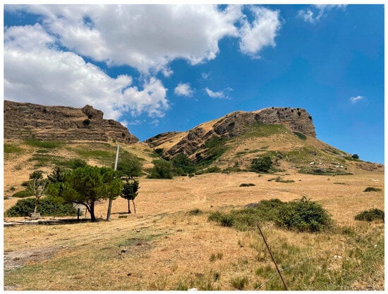
Figure 2.
The right peak of the southwest side of Montagna Vecchia, where the medieval settlement was located.
4. Materials and Methods
4.1. Archaeological Survey
Two archaeological survey campaigns were carried out in the summer of 2022 and 2023. In this phase of the research, the investigation strategy focused on verifying the many sites with possible phases from the Roman, late ancient, Byzantine, Islamic, and Norman periods (3rd century BCE–12th century CE), which had been sporadically reported over the years. In this phase of the research, therefore, an extensive investigation of portions of the territory was not carried out field by field, but we opted for an intra-site survey to understand the extension of the sites and, above all, to verify the existence of ceramic materials on the surface. The sites were mapped with mobile GPS, and the georeferenced data (points and tracks) were inserted into a GIS platform integrated with information sheets on the individual sites and the material culture connected to them. According to the directions of the Sicilian Region Archaeological Service (Superintendence BB.CC.AA. of Palermo) responsible for authorizing research, it was decided not to carry out a total collection of the material on the surface. This choice was also dictated by the limited possibilities of the conservation of the materials and to avoid completely erasing the traces on the ground of the presence of sites, thereby protecting the areas for future investigations. Therefore, we carried out an autopsy evaluation of the areal dispersion and density of the archaeological material present on the surface, and only some diagnostic materials were collected, intended to act as fragments for the reconstruction of a shape (e.g., edges, bottoms, and handles), fragments with particular surface treatments (e.g., black gloss, ARS, and painted pottery), or significant fabrics (e.g., calcitic ware). In this way, we tried to obtain a significant sample of materials useful for the chronological definition of the occupation of the various sites. In some cases, different areas of concentration or “topographic units” (UT) were identified within a site, while, in other cases where the density of the material was particularly high, it was decided to divide the areas into squares within which the material was quantified in situ before proceeding with the selective collection of diagnostic materials square by square. Finally, in some cases which will not be covered in this study, only structural evidence relating to medieval and post-medieval watermills was mapped. To address the theme of the dynamics of continuity, resilience, and change between the settlement dynamics of the Roman and late antique periods and those of the Byzantine and Islamic periods, a subset of sites was created that presented phases of occupation falling within these chronological areas.
4.2. GIS-Based Spatial Analysis
A GIS-based analysis was conducted to elucidate the relationship between archaeological sites and landscape characteristics during the Roman and Islamic periods. The study encompassed 17 sites categorized into three macro-historical periods: (1) Roman, (2) Byzantine, and (3) Islamic.
The area of concentration of ceramic materials for each site, detected in the field with GPS, was mapped in GIS as polygons. Each polygonal feature was then used to perform zonal statistics on the raster layers, which returned the statistical values of five landscape parameters: elevation (meters above sea level), slope (degrees), aspect (degrees to the north), topographic position index (TPI), and water distance (meters).
The processing was carried out using both Esri ArcGIS 10.2 and QGIS 3.28 for all terrain covariates. The raster layers were processed starting from the LIDAR-DTM of the Sicilian region with a cell size of 2 m [73].
TPI values, as formulated by Weiss [74], facilitated the classification of the landscape into six slope position categories: (1) valley, (2) lower slope, (3) flat slope, (4) middle slope, (5) upper slope, and (6) ridge.
For the distance from water sources, the nearest distance was calculated from the hydrographical network obtained from the regional technical map of Sicily at a scale of 1:10,000 [73]. Given that it is a hilly and mountainous area, the morphological dynamics of the watersheds, as well as the other topographical factors considered, are not affected by significant natural changes in spatial terms over the time scale of the last two thousand years, such that they would influence the results of the analyses considered.
The extracted values were then recorded in a table, which was used for statistical analyses in R [75]. Given the limited size of the dataset, an exploratory data analysis was performed to understand the value distribution better. A boxplot was created to visually represent the data distribution across different periods to determine the differences between groups.
To understand and interpret the relationships between the topographical variables considered (elevation, slope, aspect, TPI, and water distance) and visualize how the sites group together, a principal component analysis (PCA) was carried out, with the results displayed as a biplot. The PCA is a technique widely used in exploratory data analysis, specifically with multivariate data [76]. The biplot visually represents the relationships between the variables and their impact on different archaeological sites and periods.
To interpret the distribution of the sites in relation to the ecological characteristics of the territory, a vegetation series map was created according to the methodology proposed by Bazan et al. [46]. The vegetation series (or sigmetum) depicts a set of plant communities within homogeneous environmental areas (tessella or ecotope), which are stages of the same ecological succession process, and the series serves as synthetic indicators of all environmental characteristics (climate, lithology, and landforms). As ecological indicators, vegetation series are also indicators of potential land use suitability. The fact that it is based on factors whose change generally takes tens of thousands of years [77] allows the use of vegetation series as indicators of potential land use, even in retrospective terms. The frequency of different vegetation series was analyzed within a 250 m buffer around each site using R.
5. Results
In total, 53 sites from different periods were identified through bibliographic research and field surveys and mapped in a GIS environment (Table S2, Figure S1). From the general dataset of the sites, a group of sites relevant from the point of view of the settlement dynamics of the Roman and Islamic eras was identified. In particular, these are sites falling into four thematic categories: (1) topographical continuity of Roman sites during the Islamic period; (2) new settlement patterns during the Byzantine period; (3) early medieval reoccupation of pre-Roman sites; and (4) new Islamic settlements.
5.1. Topographical Continuity of Roman Sites during the Islamic Period
5.1.1. Contrada Zuccarone (CRL29)
The Contrada Zuccarone is located about 5 km southeast of Corleone and about 1 km north of the “Strada Statale 118 Corleonese-Agrigentina”, between the local road Agnone-Zuccarone (to the north) and the “Regia Trazzera N. 81, Bivio Amendola—Portella dei Giudei—Bivona (east-west)” and the “Regia Trazzera N. 481, Bivio Cicio—Bivio Cappuccio (north-south)”. The only Roman milestone found in Sicily was discovered in Contrada Zuccarone in 1954. The milestone bore the inscription [C. A]VRELIVS/[L.F.]COTTAS/[C]ONSOL/↓VII, in reference to the consul C. Aurelius Cotta (252, 248 BCE) [65,66]. It is still debated whether the milestone was connected with the construction of an official road network in the 3rd century BCE or whether this milestone was a trophy or a terminal stone [65] connected to the phases of the conquest of the territory by the Romans during the First Punic War (264–241 BCE). Despite this, the discovery is certainly connected to the proximity of the Contrada Zuccarone to a road route that was connected with a stretch of the Palermo–Agrigento road mentioned in the Itinerarium Antonini [78]. During our archaeological survey, we had the opportunity to systematically document, for the first time, an archaeological site located in the area of the discovery of the milestone and, in particular, on a small hill of approximately 800 m above sea level. This site was approximately 80 m higher than the access road below, which was near a watering trough. In a vineyard (CRL29_UT1) with an eastward slope, we identified a dense concentration area (about 4100 m2) of ceramic materials (Figure 3). Given the considerable concentration of materials, we divided the area into 35 squares, according to the rows of vineyards, and quantified the material in situ with a selective collection of diagnostic material for each square (Table S3).

Figure 3.
Map of the density of ceramic fragments per m2 in the two topographic units (UT1 and UT2) identified in the Contrada Zuccarone site (CRL29).
According to diagnostic materials (Figure 4), the site seems to have been frequented, starting from the middle Hellenistic age, for about one or two centuries, after which there seems to have been a hiatus until the Early Imperial age when the frequentation resumed. Continuous ensuing habitation from that time was demonstrated until Late Antiquity.
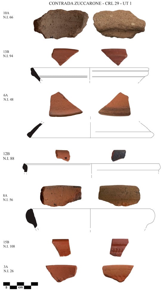
Figure 4.
Hellenistic and Roman pottery from the Contrada Zuccarone site (CRL29_UT1). 10A, N.I. 66: worn rims referable due to their texture (numerous volcanic inclusions of Tyrrhenian origin) and typology to MGS amphorae and probably dating back to between the 4th and 3rd centuries BCE [79]. 13B, N.I. 94: fragment of an African Red Slip A cup, Hayes 8B form, with an undecorated strip (2nd century CE) [80]. 6A, N.I. 48: a fragment of rim of plate lid with cinerish patina of Hayes 196 form/Bonifay types 11.5 (2nd–5th century) [80,81]. 12B, N.I. 88: almond-shaped rim and vertical body of a North African cooking pot (casserole) related to the Hayes 197 form (4th–5th century) [80]. 8A, N.I. 56: a fragment of the rim of a cooking pan of Pantellerian ware (4th–5th century) [82,83]. 15B, N.I. 108: a fragment of a rim of an African Red Slip D cup with “nailed” decoration on the external body of a Hayes 81 A/Bonifay type 43–44 form (half/second half of 5th century) [80,81]. 3A, N.I. 26: a fragment of a rim of Hayes 81A/Bonifay type 43–44 form (half/second half of 5th century) [80,81].
No valuable elements have been found on the site, and it is not easy to propose a univocal interpretation of this site; perhaps it was a villa, which, in any case, would seem to be well connected to regional and extra-regional commercial circuits until the end of Late Antiquity.
Despite this, the occupation of this area continued beyond Late Antiquity. In fact, in the field adjacent to the southern side of the vineyard (currently uncultivated but with soil devoid of surface vegetation), another area of concentration of materials was identified (CRL29_UT2), covering approximately 4900 m2, mainly from the Islamic era. In fact, among the diagnostic materials found, we noted the characteristic tiles with vegetal inclusions, some of which also had engraved streaks, which, in association with painted and glazed ceramics, allow us to hypothesize human presence in the Islamic era (Figure 5).

Figure 5.
Islamic pottery from the Contrada Zuccarone site (CRL29_UT2). N.I. 292–295: painted amphorae/jugs. N.I. 297: Islamic glazed pottery.
In particular, numerous fragments of the walls of amphorae/jugs were found alongside a modest quantity of handles. Many of the walls are painted in both red and brown: among the most common decorative motifs, we found the broad band motif (Figure 5, N.I. 292), a sinusoidal motif with vertical lines alternating with sinusoidal ones rendered with brushstrokes of the same thickness, which appears in the contexts of the end of the 9th century. During the first half of the following century, the sinusoidal lines were gradually modified to cursive lines until the motif transformed into the variant with parallel bands and detached sections, also, in this case, possessing lines of the same thickness (mid-10th–mid-11th century). In the Zuccarone district site, in particular, the most widespread decorative motifs are the sinusoidal motif (Figure 5, N.I. 293) and the motif with parallel detached lines (Figure 5, N.I. 294–295); the cursive sinusoidal motif is less attested (Figure 5, N.I. 296) [84]. In the same UT, fragments of glazed ceramics were also found: for example, a fragment pertaining to an open shape with green and brown decoration (Figure 5, N.I. 297) was found, comparable to a piece found in urban and suburban excavations in Palermo in contexts dated to the second half of 10th/mid-11th century such as in the Gancia [85,86] and in the cesspits/silos of Via Imera [87].
5.1.2. Case Scalilli–Gole del Drago (CRL23)
In the northern part of the municipality of Corleone, there is a promontory of calcarenite rock (max. elevation 498 m a.s.l.), stretched in a NW–SE direction, bordered on the west by the Frattina torrent, from which the Belice Sinistro River originates and which, at this point, forms the natural waterfalls named Gole del Drago. This promontory is located 350 m east from State Road 118 “Corleonese-Agrigentina”. In this area, 18 different topographical units (UTs) of concentration of archaeological materials were identified (Table S4) UT14, UT15). These materials were found around the Case Scalilli–Gole del Drago, located east of the promontory (UT1, UT2, UT7, UT16, and UT17), and in the olive grove north of the promontory, beyond the access road to the site (UT18) and about 90 m southeast of the Case Scalilli–Gole del Drago (UT8) (Figure 6).
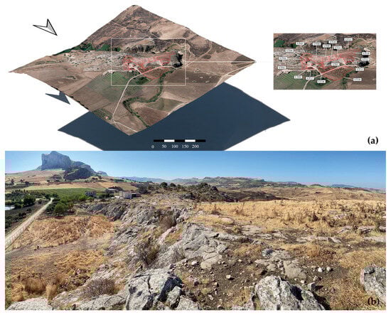
Figure 6.
(a) Topographic units identified in the Case Scalilli–Gole del Drago site (CRL23); (b) the rocky plateau at the top of the isolated relief at the Case Scalilli–Gole del Drago site.
In the lower eastern part of the limestone promontory and near the Case Scalilli–Gole del Drago, areas were identified (UT1, UT2, UT7, and UT16) in which it was possible to recover material, mainly from the Roman period (Figure 7).
The site presents an important phase dating back to the Early Imperial age, which was followed by survival (possibly with contraction) until the early Byzantine age. It would seem to be one of the sites where activity began at the end of the 1st century BCE, perhaps in relation to the colonial deduction of which we have traces in literary sources.
In the Islamic period, the occupation of the site moved to the upper part of the limestone promontory on the Dragon Gorges. The topographic units refer to this occupation (UT3, UT4, UT5, UT6, UT9, UT10, UT11, UT12, UT13, UT14, and UT15), while the area downstream of the northern promontory (UT18) appears to be connected to more sporadic visits and the south (UT8).
This medieval occupation is evidenced by the presence of fragments of polychrome glazed ceramic, such as the fragment of a ring-bottom found with a phytomorphic/vegetal motif under a transparent glaze (Figure 8, UT 14, N.I. 187) dating back to the first half of the 11th century or the mid-11th century [88]. Other fragments found in the various UTs belong to the same class, but the decoration is not always present or identifiable: for example, a fragment of a wall belonging to an open form with a transparent window and a nonreadable decoration in green and brown are cited (Figure 8, UT 15, N.I. 288), as is a ring foot fragment with green glaze (Figure 8, UT 15, N.I. 188). The discovery of several fragments of amphorae/jugs was also reported. Many of these are painted both red and brown (Figure 8, UT 15, N.I. 291). The most frequently identified decorative motif with parallel detached lines (Figure 8, UT 14, N.I. 286–287) appeared around the mid-10th century and remained unchanged until the middle of the following century. During the 12th century, the oblique strokes tended to become thinner and more spaced out (Figure 8, UT 15, N.I. 290) [84]. There is no shortage of evidence of other types of materials, as evidenced by the fragment of the edge of a circular plate lamp with a small dome reservoir (Figure 8, UT 15, N.I. 289), a type that appears in contexts from the second half of the 9th century but which persisted at least until the second half of the following century [89]. The fragments of green monochrome glazed ceramic (Figure 8, UT 14, N.I. 185–186), internally bearing a furrowed continuous ribbon decoration with parallel transversal sections, are, however, to be referred to a later occupation of the site (12th century) [90,91].
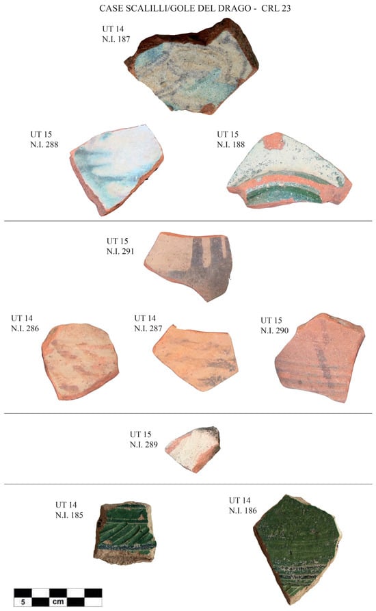
Figure 8.
Shards of Medieval pottery from the Case Scalilli–Gole del Drago site (CRL23). UT 14, N.I. 187; UT 15, N.I. 188; UT 15, N.I. 288: glazed pottery. UT 15, N.I. 291; UT 14, N.I. 286; UT 14, N.I. 287; UT 15, N.I. 290: painted amphorae/jugs. UT 15, N.I., 289: lamp. UT 14, N.I. 185; and UT 14, N.I. 186: glazed pottery with furrowed decoration.

Figure 7.
Roman pottery from the Case Scalilli–Gole del Drago site (CRL23). UT7, N.I. 136: a small cup in terra sigillata, approximately 15 BCE—50 CE [92]. UT7, N.I. 132: a cup in African red slip A with everted rim and subhorizontal brim, Hayes 32 form [80] (1st–2nd century CE). UT7, N.I. 167: a bowl in African Red Slip F [93] with an indistinct rim and vertical body may be similar to Hayes 50 (mid-5th century CE) [80]. UT7, N.I. 124: an amphora Africana IIIA (4th century) [56].

5.2. New Settlement Patterns during the Byzantine Period
Small Byzantine Sites: Costa Rubina (CRL40), Contrada Casale (CRL44), and Case Bingo (CRL47)
Regarding the period of occupation of this territory during the late antique and Byzantine periods, we do not have much definite information on the settlement typologies if we exclude sites with long continuity until the 5th–6th century, such as the aforementioned cases of Contrada Zuccarone and Case Scalilli–Gole del Drago. From irregular excavations between the 1950s and 1970s, some ceramic and glass materials from 5th–6th-century grave goods come from the Bisagna and Carrubba districts [39,94], while a group of 6th–7th-century grave goods appear to come from the Palastanga locality (not identifiable with certainty). Golden basket earrings and ceramics characterize these and include a jug decorated on the body with two overlapping irregular painted bands of vertical stripes in red, a lanceolate shape in the upper part, a comma shape in the lower part, and with a thin horizontal band on the edge [95] (Figure 9).
From our archaeological survey, we identified sites of limited extension at Costa Rubina (CRL40, area size of 6245 m2), Contrada Casale (CRL44, area size of 1744 m2), and Case Bingo (CRL47, area size of 2931 m2). These sites are united by the low density of fragments of ceramic pottery and characterized by the almost exclusive presence of fragments of striped/combed tiles (Figure 10), a typical indicator of the Sicilian contexts during the Byzantine era between the late 6th and 7th centuries [96].
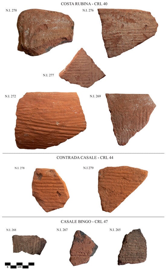
Figure 10.
Byzantine striped/combed tiles from the Costa Rubina (CRL40), Contrada Casale (CRL44), and Case Bingo (CRL47) sites.

Figure 9.
Earrings (a,b) and painted ceramic jugs (c,d) from grave goods of the Byzantine period (6th–7th century) from the Palastanga area in the Corleone area (reworked from Dannheimer [97] to Metaxas [98]).
Figure 9.
Earrings (a,b) and painted ceramic jugs (c,d) from grave goods of the Byzantine period (6th–7th century) from the Palastanga area in the Corleone area (reworked from Dannheimer [97] to Metaxas [98]).

5.3. Back to the Hilltop: Early Medieval Reoccupation of Pre-Roman Site
Contrada Castro (CRL53) and Cozzo Spolentino (CRL11)
The site of Contrada Castro (CRL53) was identified following systematic reconnaissance during 2015–2016 [99]. It is located on a high plateau south of the rocky slope of the highest relief of Pizzo Castro/Rocche di Mezzogiorno in the southern part of the municipal territory of Corleone, almost on the border with the municipality of Campofiorito. From 2017 to 2021, several excavation campaigns were carried out [27,28,30], which led to the identification of an interesting sequence of occupation divided into four main periods of the pre-Roman period and Byzantine–Islamic transition age: (1) late 6th–4th century BCE; (2) late 7th–early 8th century CE; (3) late 8th–9th century CE; and (4) 10th–11th century CE. The first phase of occupation of the site dates back to the late archaic/classical period (late 6th–4th century BCE), to which several walls probably connected to residential units. After a long hiatus, the site was reoccupied in the early Middle Ages. The first evidence of this re-frequenting is children’s tombs dated by radiocarbon analyses between the end of the 7th century and the beginning of the 8th century CE. In the late 8th–9th century, the site of Contrada Castro saw a building intensification documented by the construction, in the two excavation areas investigated, of a warehouse/deposit with a deep silo inside. At the end of the 9th century, these buildings were obliterated, and from the beginning of the 10th century CE, other buildings (houses) were built with a completely divergent orientation compared to that of the previous phase. This last phase, heavily eroded over the centuries by subsequent plundering and agricultural activities, can be seen within the full Islamic era (10th–11th century), after which the site was only sporadically frequented between the end of the 11th and the beginning of the 12th century. This site has been the subject of multidisciplinary analyses focused on the study of human–environment interactions, which have highlighted—through zooarchaeological, archaeobotanical, and phytosociological analyses [100]—a long-lasting continuity in the exploitation of environmental and animal resources [101]. The ceramic record demonstrates a good level of economic complexity in this inland area, in which the presence of amphorae produced in Palermo testifies to an exchange connection between the city and the countryside [102].
A similar dynamic of reoccupation of a high-altitude site (about 950 m above sea level) from the pre-Roman era during the early Middle Ages could be that of Cozzo Spolentino (CRL11). At this site, emergency excavations in the 1990s brought to light layers of use with ceramic materials, still unpublished, which could refer to the early Middle Ages [42].
5.4. New Islamic Sites
5.4.1. Casale di Sotto (CRL3), Casale di Sopra (CRL4)
Starting from the full Islamic age (at least during the 10th century), new sites emerged in lowland areas connected to roads and on high ground. The most interesting case is represented by the evidence in Contrada Casale (Municipality of Monreale), located on the southern slope of the Rocca Busambra mountain, on the border between the southern part of the Municipality of Corleone and the Municipality of Monreale, and delimited to the south by the Bicchinello stream, a tributary of the Frattina stream. In the 1980s, the first identification of two sites was carried out [103]: one in the Casale di Sotto area (CRL3), on the plateau (558 m above sea level, below the rocky part of this side of the Rocca Busambra), and another in the Casale di Sopra area (CRL4), on the top of a high plateau (826 m above sea level) located on the offshoot of the limestone massif of Rocca Busambra and accessible from the south through the Piano Pilato plateau (794 m above sea level) (Figure 11a).
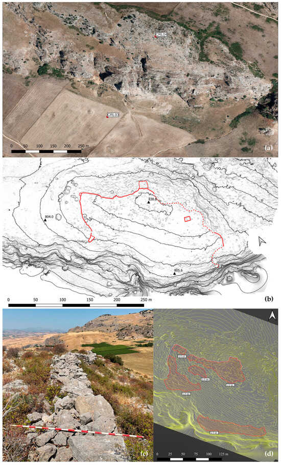
Figure 11.
(a) Topographic location of the sites of Casale di Sotto (CRL3) and Casale di Sopra (CRL4); (b) map of the fortification line of Casale di Sopra; (c) the fortification wall of Casale di Sopra; (d) topographic units of concentration of pottery inside the wall of Casale di Sopra.
The Casale di Sopra site is defined by a fortification wall, which is preserved for a length of 243 m. In some places, it is often almost 2 m high and constructed of freshly rough-hewn stones laid dry without the use of mortar binder (Figure 11b,c). This line of wall encloses the plateau on three sides: north, east, and west (where a small door opens). To the south, the site is naturally defended by the wall of the promontory, which has a practically sheer morphology. Overall, the surface area enclosed by the fortification is equal to approximately 30,903 m2.
Despite the strong erosion of the site, which in some places has outcropping rock, five topographical units have been identified (Figure 11d; Table S5); these have yielded a large number of ceramic finds.
The most frequently observed class was that of vacuolated tiles with vegetable inclusions. Some fragments relating to amphorae (Figure 12) are equally interesting, and they often have a decorative motif of wide brown bands on the external surface (Figure 12, UT 2, N.I. 281). Among the rims within the same class, examples were identified consisting of a rim with a triangular section (Figure 12, UT 1, N.I. 2) or a pendulous triangular section (Figure 12, UT 2, N.I. 239–240; UT4, N.I. 242), likely related to Palermo production, which dates back chronologically to between the second half of the 10th and the beginning of the 11th century [104]. The other fragment of an almond-shaped rim (Figure 12, UT 5, N.I. 244) also refers to Palermo production and is enlarged with two evident concentric grooves on the outside. This type of amphora, dated to the 11th century, belongs to containers with a wide mouth [84,105].
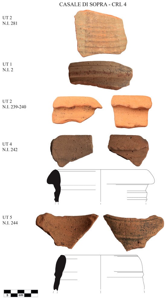
Figure 12.
Islamic amphoras from Casale di Sopra (CRL4). UT 2, N.I. 281: painted amphora. UT 1, N.I. 2; UT 2, N.I. 239–240; UT 4 N.I. 242; and UT 5, N.I. 244: amphoras.
Regarding glazed pottery (Figure 13), among the different types identified, a fragment of a ring foot was found. This was of an open form, with a transparent glaze and balanced leaf decoration in green and brown (Figure 13, UT4, N.I. 243) [88,106]. The source of its production is currently uncertain, and it can be dated to between the second half of the 10th and the first half of the 11th century. In addition, a fragment of a thickened rim with traces of green glaze was identified (Figure 13, UT3, N.I. 241). This, most likely, was produced later (12th century CE). In fact, the shape seems to recall the so-called keeled basins with a lowered cap, such as those found in the exhaust of the kiln of Palazzo Lungarini [107] and in the workshop at the Santa Cecilia theater, both in Palermo [108]. Based on the study of the finds, it is clear that the site of Casale di Sopra seems to have had evident use during the Islamic period (second half of the 10th–11th century), with some sporadic traces of use in the Norman age.
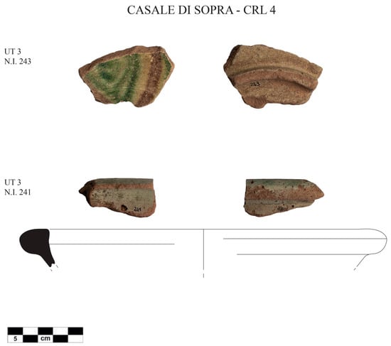
Figure 13.
Medieval glazed pottery from Casale di Sopra (CRL4): UT 3, N.I. 243; UT 3, and N.I. 241.
At the foot of the steep wall, towards the south, medieval materials were collected in the Casale di Sotto site area. This was previously reported in the surveys of the 1980s [103].
5.4.2. Masseria Magione (CRL7), Case Grandi di Giammaria (CRL43), and Contrada Carrubba (CRL49)
Furthermore, materials from the end of the 9th to the 11th century were found in other open sites on the valley floor, such as those at Masseria Magione (CRL7), Case Grandi di Giammaria (CRL43), and Contrada Carrubba (CRL49). Of the three sites, those that have returned the most diagnostic material are Masseria Maggione and Contrada Carrubba (Figure 14). The most significant and numerically largest finds belong to the class of amphorae, likely also, in this case, as in the Casale di Sopra site of Palermo production. Among the most recurring painted decorative motifs, we found the sinusoidal motif (Figure 14, N.I. 292, late 9th–early 10th century) and the sinusoidal cursive motif (Figure 14, N.I. 283, first half of the 10th century) with wide bands of both brown and red (Figure 14, N.I. 284) at the site of Masseria Maggione. At Contrada Carruba, we also identified the motif of parallel detached lines in brown (NI 261–262, mid-10th–11th century) [84]. The only fragment of the rim of an amphora from Masseria Maggione (Figure 14, N.I. 194) refers to that of the same type found on the site of Casale di Sopra and dated to the 11th century (see above Figure 12, UT5, N.I. 244). Finally, a fragment of an olla (cooking pot) rim with an everted and rounded almond-shaped brim (Figure 14, N.I. 192), identified as fire pottery, was found. The rim, probably of Palermo production, dates back to between the end of the 9th and the first half of the 10th century [109].
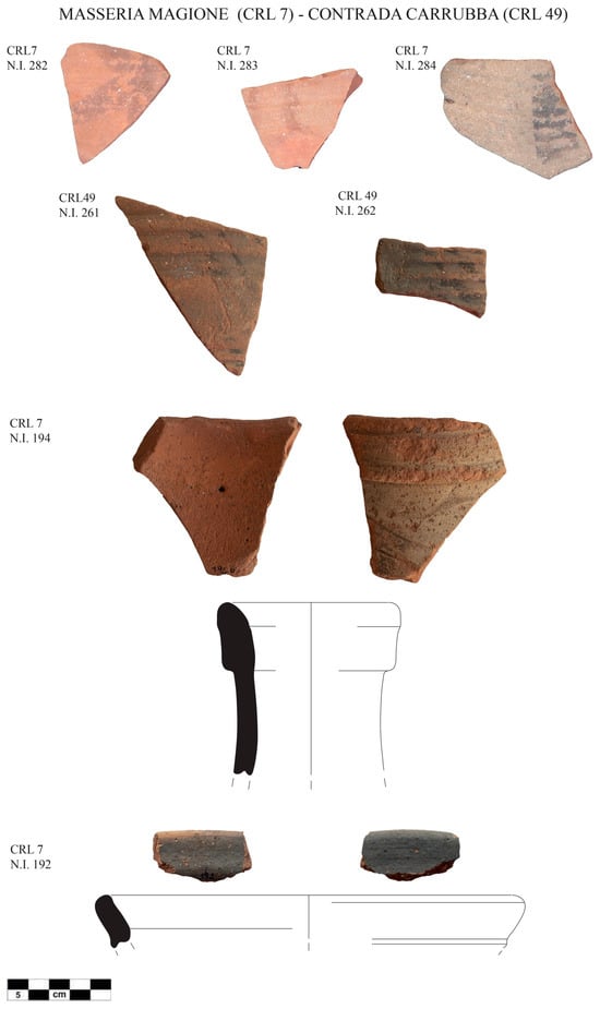
Figure 14.
Shards of Islamic painted amphoras and cooking pots from the Masseria Magione (CRL7) and Contrada Carrubba (CRL49) sites. CRL 7, N.I. 282; CRL 7, N.I. 283; CRL 7, N.I. 284; CRL 49, N.I. 261; and CRL 49, N.I. 262: painted amphorae/jugs. CRL 7, N.I. 194: amphora. CRL 7, N.I. 192: cooking pot.
5.5. Landscape Position Analysis
GIS-based analyses focusing on settlement dynamics between the Roman and Islamic periods were conducted on a collection of 17 sites. This included those previously described with Islamic era phases and sites exclusively occupied during the Roman period.
The GIS analysis of the sites’ positions in relation to the topographic characteristics of the landscape first resulted in the creation of GIS maps depicting the elevation, slope, aspect, TPI, and water distance (Figure 15 and Figures S2–S6). The mean value of each parameter for each site, calculated using zonal statistics, is shown in Table 1.
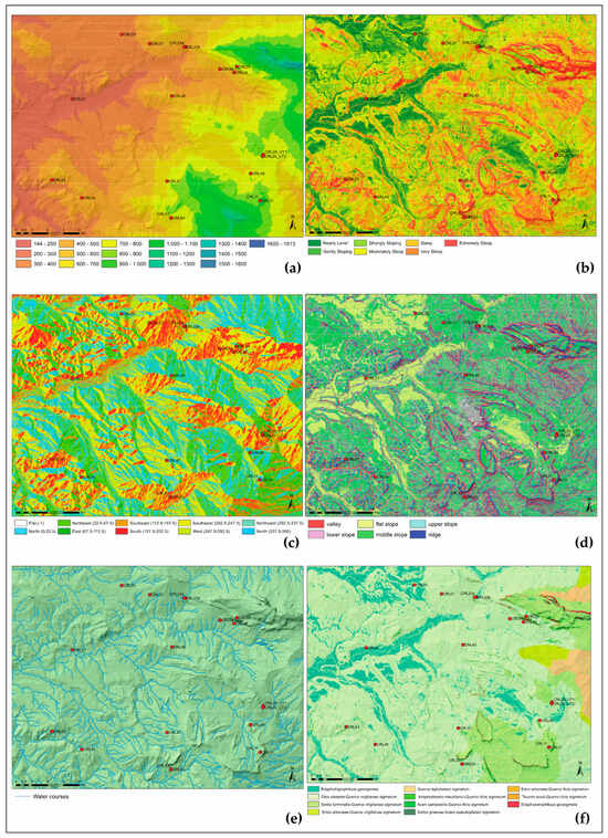
Figure 15.
Maps of GIS-based spatial analyses of key environmental variables: (a) elevation [m], (b) slope (°), (c) aspect (°), (d) TPI, (e) water distance [m], and (f) vegetation series. Red circles are archaeological sites.

Table 1.
Topographical parameter of analyzed sites.
The analysis of the distribution of variable elevation across different periods (Figure 16a) shows that the Roman sites have a median altitude value of 465 m above sea level, which is lower than those for the Byzantine period (709 m above sea level) and the Islamic period (711 m above sea level). However, within the group of Roman sites, there is a site (CRL29_UT1) with an “outlier” elevation value of 798.15 m above sea level. Similarly, in the group of the Byzantine period, there is a site (CRL11) with an elevation value of 952.08 m above sea level, which significantly differs from the average. An interesting observation is that, in general, the altitude of the Roman sites tends not to overlap with the higher altitudes of the sites from the Byzantine and Islamic periods. From a morphological point of view, the medians of the slopes (Figure 16b) increase from the Roman period (7.9°) to the subsequent Byzantine (9.3°) and Islamic periods (10.9°). In general, these median values correspond to two slope gradient classes: “moderately sloping” (4.7°–9°) and “strongly sloping” (9.1°–16.7°), according to the USDA [110].
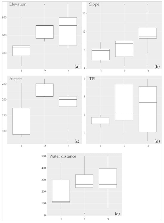
Figure 16.
Boxplots representing the distribution of key environmental variables across different periods at archaeological sites. Each plot corresponds to a unique variable: (a) elevation [m], (b) slope (°), (c) aspect (°), (d) TPI, and (e) water distance [m]. The boxplots are categorized by the Roman (1), Byzantine (2), and Islamic (3) periods and illustrate the range, interquartile range, median, and potential outliers within each period.
However, there are some outliers among the sites from the Byzantine and Islamic periods, which are located in “gently sloping” (CRL53) and “steep” (CRL11) positions. Regarding the aspect variable (Figure 16c), the Roman sites have median values that indicate an eastward aspect, while the Byzantine and Islamic sites tend to face southwest. The most frequent TPI class (Figure 16d), based on the medians for all three periods, is the middle slope (class 4). The values of the median distances from watercourses per period are as follows: 115 m for the Roman period and 262 m for the Byzantine and Islamic periods (Figure 16e).
A PCA biplot reveals a data distribution pattern along a gradient of topographic factors consistent with the data described in the boxplot (Figure 17). The PCA identifies the existence of at least three clusters of sites exhibiting similar topographic characteristics. The first cluster comprises six sites, including four from the Roman period (CRL20, CRL23a, CRL27, and CRL45) and two from the Islamic period (CRL03 and CRL07). These sites have an average elevation of 434 m above sea level, an average slope of 7.5°, an average aspect of 167° (S), a TPI of 3–4 (flat slope/middle slope), and a water distance of 203 m. The second cluster consists of three sites occupied during the Islamic era (CRL23b, CRL43, and CRL53), featuring average elevation values of 552 m above sea level, an average slope of 9.4°, an average aspect of 196° (S), a TPI of 5 (upper slope), and a water distance of 144 m. The final cluster includes two sites also occupied in the Islamic era [CRL11, CRL04], with average elevation values of 888 m above sea level, an average slope of 17.1°, an average aspect of 209° (SW), a TPI of 5–6 (upper slope/ridge), and a water distance of 409 m.
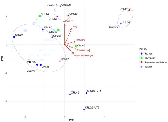
Figure 17.
PCA biplot depicting the distribution of archaeological sites categorized by period. Each point represents a site positioned according to the first two principal components (PC1 and PC2) derived from environmental variables. The red arrows indicate the direction and strength of the variables’ association with the principal components. Sites are visually distinguished by period: Roman (1), Byzantine (2), and Islamic (3).
The ecological analysis of the landscape conducted in terms of vegetation series led to the creation of a map in which 11 types have been identified (Figure S7).
The zonal statistic of the area surrounding the sites (250 m buffer) indicates that the landscape is predominantly characterized by two calcicolous series of downy oak (Figure 18). For CRL_11, due to its elevated location (>900 m asl) within the bioclimatic zone of the meso-supramediterranean subhumid ombrotype, the vegetation series is almost entirely (91.7%) represented by the Sorbus-Quercus virgilianae sigmetum. The other sites, which fall within the thermo-meso-Mediterranean subhumid bioclimatic zone, are primarily characterized (over 80% in 11 sites) by the Olea-Quercus virgilianae sigmetum series. In both instances, the remaining forest vegetation is comprised of woodlands dominated by Quercus pubescens, located in mountainous and hilly areas with soils of varying depths. This pedological feature provides this ecological context with good productive potential, especially for cereal cultivation, which has been the predominant type of land use in the hilly areas for centuries. In three Roman period sites (CRL20, CRL23a, and CRL27), the vegetation context is partially influenced by a sub-flat terrain with alluvial soils where the potential vegetation is represented by edaphohygrophilous sigmeta (27%, 19%, and 40%, respectively, for the three sites). From an agricultural standpoint, these areas with a good productive capacity are used for the cultivation of cereals and produce from vineyards.

Figure 18.
Frequency of surface assigned to a different vegetation series in the surrounding area of each archaeological site.
6. Discussion and Conclusions
The territory of Corleone reveals itself as a crucial territory for the analysis of the settlement dynamics in the transition from the Roman to the Byzantine and Islamic periods. In fact, being in a strategic position for the connection axis between two important cities such as Panormus/Balarm (Palermo) and Agrigentum/Kirkant-Jirjant (Agrigento), it lends itself to this type of diachronic analysis of the change and resilience of settlement patterns. We have seen how, in Roman times, the sites mainly occupied locations at the bottom of valleys with a close connection to the road axes and water resources. The connection with the road network of the Roman era is demonstrated by the notable quantity and variety of products that were imported, as evidenced by amphorae, ARS, and fire ceramics, which, until Late Antiquity, reached the territory of Corleone from North Africa and Pantelleria. The significant presence of Pantellerian ware from the 4th to 5th century CE provides evidence of the latter. These ceramic imports reveal a significant connection with extra-regional trade flows, a characteristic that defines the entire internal region of the Sicani Mountains. In the adjacent territory of Contessa Entellina, bordering the Municipality of Corleone to the west, decades of meticulous research by the survey have uncovered similar patterns [40]. This is particularly noted in the discovery of materials in Contessa Entellina that closely resemble those found in the Corleone area, indicating a shared belonging to similar long-distance exchange networks.
Even in the Islamic era, the territory seems to continue to be connected to an active road network; although, during this era, it is within a changed economic condition that no longer sees massive extra-regional imports but a dynamic of city–countryside exchange attested to by the presence of glazed ceramics, which seem to link this agricultural territory with the urban markets and port of the capital, Palermo. Evidence from the Byzantine era, to this day, still appears incomplete due to the scarcity of documentation, and it is still to be assessed whether, after a reorganization of the properties after the end of the villa system [14], there was a rearrangement of the population according to new subdivisions of the property and new management of the earth through the system of massae fundorum [111,112]. Uncovering small Byzantine sites in the Corleone area, marked solely by roof tiles decorated with combed impressions, might suggest a hierarchical structure of 6th-7th century settlements featuring sites of diverse sizes and purposes. A similar pattern emerged in the adjacent area of Contessa Entellina [40], where larger, material-rich sites containing imported goods and fine tableware ceramics coexisted alongside smaller sites, identifiable only by comber/striped tiles akin to those in the Corleone territory. This phenomenon extends to other Sicilian regions, like the Alesa area in the northern coast’s hinterland, where sites bearing these characteristics have been identified and interpreted as temporary structures linked to combined agricultural and pastoral uses [113].
Another unresolved problem is that of the changes that occurred during the constitution of the theme (Byzantine military province [114]) of Sicily—an important administrative reform of the Byzantine Empire—between the end of the 7th and 8th centuries and, above all, during the process of “militarization” [16,17,20,115] that characterized the island in the previous decades and included the landing of the Aghlabid army in Mazara in 827 CE [2]. It was perhaps precisely during this period of the late 8th and early 9th centuries that the pre-Roman highland sites that had been abandoned during the previous centuries began to be reoccupied, as demonstrated by the example of Contrada Castro. The hills became attractive for settlement in the Islamic era. This occurred in parallel with a new population settling in the valley bottom, both in places not previously settled and in proximity to settlements from the Roman era, demonstrating a new productive boost in the agricultural economy of the Sicilian hinterland. The case of the Islamic era occupation of Casale di Sopra, in particular, opens up interesting perspectives on the types of occupation of the hills due to the presence of fortified enclosures connected either for defensive purposes/control of the territory or as occupation nuclei also connected to the shelter of the livestock. All of these hypotheses could be verified and analyzed with archaeological excavations. The fact of being able to trace a settlement equipped with a fortification enclosure to the Islamic era remains important, given that there are quite a few examples in Sicily of fortified sites dated, with certainty, to the Islamic period, such as the fortified granary of Pizzo Monaco [116], or to the phases of the 10th–11th century of the castles of Calathamet [117] or Calatubo [118] in the province of Trapani.
The GIS approach to the relationship between site positioning and environmental factors has not been widespread in the study of settlement dynamics in post-classical rural landscapes in Sicily. Some applications have been created to understand the relationships between water sources and Islamic sites in the province of Trapani [119] or the distribution of medieval fortified sites in Sicily based on their viewsheds [120]. Our study proposed an original GIS-based approach to the transition between Roman and Islamic settlement patterns.
The landscape position analysis contributed to our understanding of the settlement dynamics of this territory and the relationships of topographic and ecological factors with political, social, and economic changes over time. The statistical analysis (PCA) of the topographic factors (elevation, slope, aspect, TPI, and water distance) made it possible to highlight clusters that show coherent topographic characteristics in the positioning of the settlements. The integration of spatial information with historical information highlighted common characteristics that would otherwise not have emerged from a simple statistical analysis or descriptive historical observation.
The first cluster is made up of four sites from the Roman era (CRL20, CRL23a, CRL27, and CRL45) and two from the Islamic era (CRL03 and CRL07); these are located at the bottoms of valleys, at low altitudes, and in slightly steep positions consistent with the agricultural exploitation of the territory and likely connected with the road network. Notably, this cluster includes the majority of Roman sites and two sites from the Islamic period, which present particular characteristics. The Casale di Sotto site is located in an area close to the passage of a road axis, evidenced by the nearby presence of an old bridge named Ponte del Casale, now out of use, which permits the Fosso del Bicchinello stream to be crossed.
This site has been interpreted as the Casal Buchinene/Bū Kināna [33,103] mentioned in written sources from the Norman era of the late 12th century [121,122]. The connection with an ancient road axis could be related to the hypothesis, cited in the Itinerarium Antonini [78], that the Roman statio Pirama was located in this area 4 km north of the miliarium of Zuccarone (i.e., at mile LVII) of the Panormus-Agrigentum road (24 miles north of Casale San Pietro a Castronovo di Sicilia (statio Petrina) and 24 miles south of Palermo), although hypotheses are still unresolved regarding the location of this Roman statio. It may have been located in the area between Pizzo Nicolosi [123] or in the aforementioned site of Casale di Sotto or further north, therefore, in contradiction to the distance of the miliarium of Zuccarone near the Nor-man hospital of Sancte Agnes [124], located at the site of Contrada Sant’Agata in Piana degli Albanesi, where a large necropolis of Late Antiquity was identified [125]. The continuity of use, in medieval times, of a road axis connecting Palermo and Corleone was witnessed in the sources of the Norman era by a road (via) quae ducit in Corilione ad Panormum [124], near which the aforementioned Norman hospitalis of Sant’Agnese stood and the publica via que ducit a panormo ad briacam that corresponds to a stretch of road located further south of Contrada Casale and which connected Corleone to Prizzi [124].
The site of Masseria Magione, where 10th–11th-century materials have been identified, currently appears as a fortified grange in which a probable residence of the commander of the Haiarzeneto fiefdom, which came into possession of the Order of the Teutonic Knights, was located as of the 1240s [126,127]. Therefore, this site was strategically positioned close to a road axis, functional for the management of agricultural resources and rural infrastructures such as water mills (Primary source “Archivio di Stato di Palermo, Tabulario della Magione”: March 1243, ASP TM, 43; 10 May 1260, ASP TM, 87; and 23 March 1293, ASP TM, 258).
These two sites reveal how, even in the Islamic period and, subsequently, between the 12th and 13th centuries, topographical proximity to the road axes and centrality with respect to the agricultural spaces of the valley floor continued to represent decisive factors in the occupation of the territory.
The second cluster is made up of three sites from the Islamic era (CRL23b, CRL43, and CRL53), which are all located in flat terraces in small reliefs towering over the surrounding territory and which, therefore, allow both good defensibility and favorable visibility to control the territory. In this regard, it is interesting to underline the strategic position controlling the Palermo–Corleone road system and the Frattina/Belice Sinistro River of the Islamic site near Case Scalilli/Gole del Drago. This is probably the place, which falls within the Haiarzeneti/ḥajar al-Zanāta estate (the stone of the Zanāta), to which the Raalginet/raḥl al-Zanāta (the village of the Zanāta) referred, and which was an object of donation by the Norman kings to the hospital of San Giovanni dei Lebbrosi, is located in the southern suburbs of the city of Palermo [25].
The particular conformation of this limestone promontory standing out in the middle of the valley defines this place as a real landmark, perhaps identifiable as ḥajar/stone, while the presence of materials dating back to the Islamic period makes it plausible to identify a connection between the site and a settlement connected to the Berber tribe named Zanāta [128,129].
The last cluster also refers to the Islamic period and is made up of two sites [CRL11 and CRL04], which are located in decidedly elevated and isolated positions compared to the valley bottoms and which, therefore, are characterized by the manner in which they perch upon the hills. The characteristics of a fortified site on high ground and the location on the southern slopes of Mount Rocca Busambra suggest that the site of Casale di Sopra can be identified more so with the Qalcat Bū Samra/Kala Busamara [122,124] mentioned in the Norman boundary register (jarīda) of the late 12th century [121] than with the category of the few fortified sites that include Arab personal names [130], i.e., Abū Samra, which likely reference commanders of the Aghlabid jund (Islamic army) who were assigned to defensible places and related surrounding areas [128]. This hypothesis is compelling, although we cannot dismiss an alternative interpretation of the toponym Qalcat Bū Samra. It might not refer to the castle of Abū Samra but to a “very dark” caste [131], considering that sam(a)rah could be a regional variant of samrā’, signifying “brown”, or it could mean sumrah, which translates to “brown color” [132].
However, the possibility that this site could also refer to the Qalcat ‘at Tarîq (fortress/castle/fortress of the road/way) mentioned by al-Idrisi in the mid-12th century [1] cannot be excluded. Idrisi had described the site as distant from Corleone, towards the north, nine Arabian miles away, which would correspond to three Frankish miles [70]. This would correspond to 17.748 km (if 1 Arabic mile = 1.972 m, [133]) or 17.694 km (if 1 Arabic mile = 1.966 m [134]). These attributions with places reported in 12th-century sources for a site already in use in the Islamic era remain quite problematic and not without risks. Significantly, these sources documented the presence of materials from the Islamic period on the site. The hypothesis that this site served as an enclosure-refuge for people and animals [11] is confirmed and supported by a more precise chronology. This kind of site may be similar to ḥisn-albacar [135]; this last term is derived from the Arab word baqqár, literally meaning “cattle guar” [136]. These settlements were found in al-Andalus from the 9th century onwards [137]. Investigations of excavations could better clarify the sequence of use of this site and provide further information on its function. It may have been a fortified settlement or an enclosure for less stable occupation.
In the Corleone territory, the Islamic-era settlement dynamics, succinctly put, unveil a compelling juxtaposition of hilltop settlements (exemplified by Casale di Sopra, Contrada Castro, and arguably Case Scalilli/Gole del Drago) alongside valley/flatland settlements established close to Roman/late ancient sites such as Contrada Zuccarone, or in areas previously uninhabited, like Masseria Magione, Case Grandi di Giammaria, and Contrada Carrubba. This diversified landscape shows a complexity where the hilltop vs. valley–flatland dichotomy should not be overly emphasized. More intriguing would be exploring the functions and interconnections among sites within the same region, as well as examining the presence or absence of internal social hierarchies in these settlements, something seemingly nonexistent based on recent archaeological findings [138], including those from the Islamic phase of Contrada Castro, with the exception of Calathamet. This case aligns with Islamic and Norman written sources, illustrating a collective political dynamism in rural as well as urban settlements [138]. The pottery data from sites of the Islamic era unveil another interesting trend. As already substantiated by petrographic/archaeometric analyses of pottery from Contrada Castro [102], certain types of painted amphoras indicate a significant shift in trade patterns. In rural areas, unlike the Roman/late antique period’s extra-regional scale, trade operated at a mid-range scale in Islamic period, especially along a city (Palermo)/countryside axis.
An ecological analysis of the territory, through the vegetation series, provided the basic knowledge to evaluate the relationship between the sites’ catchment area and the territory’s agricultural potential. All the sites are located in a territorial context where the oak series (Oleo oleaster-Querco virgilianae sigmetum and Sorbo torminalis-Querco virgilianae sigmetum) represent the dominant typologies. The plant communities that make up these two series are indicators of environmental contexts with more or less deep and evolved soils. In particular, in the Corleone area, vertexes and vertisols are distributed on brown soils, which have good agronomic potential, especially with regard to the cultivation of cereal [139] but also for the produce of vineyards, olive groves, and orchards. Over the centuries, the high agricultural suitability of the ecotopes of these series has led to the disappearance of the related forest formations (of which only the potential remains), which cultivated fields have replaced. All the sites analyzed, regardless of the topographic position of the hill or valley, are located within contexts with high potential for agricultural productivity. This agricultural potential has been supported over the centuries by the efficient management of agricultural space. An interesting case is represented by the documentary evidence from the Norman era of the ḫandaq (ditch)/ḫandaq al-ġarīq (literally a submerged ditch that may also mean an “underwater”, sunken, or waterfilled ditch) [140] system, probably widespread in Sicily, along with other methods of water management, during the Islamic period [141]. These methods consisted of creating canalizations to regulate surface water, as reported at the Haiarzeneti/ḥajar al-Zanāta estate area a few kilometers north of Corleone. Additional material evidence of the historical agricultural productivity of the Corleone area is the presence of a high number of water mills along the Frattina/Belice Sinistro stream, some dating back to the 12th century, and the existence of areas of medieval grain pits [142].
The integration of the archaeological survey with spatial analyses of the characteristics of the landscape allows us to propose a more accurate vision of the positioning of the sites and the choice of settlement in the various periods. The enlargement of the sample and the application of the same modeling techniques to other contexts could be an important tool to provide a spatial, quantitative, and ecological dimension to the phenomena of change, resilience, and innovation in territorial occupation between the Roman and Islamic periods.
Supplementary Materials
The following supporting information can be downloaded at: https://www.mdpi.com/article/10.3390/land13030400/s1, Figure S1: GIS map of archaeological sites; Figure S2: Elevation map of the study area with the analyzed archaeological sites; Figure S3: Slope map of the study area with the analyzed archaeological sites; Figure S4: Aspect map of the study area with the analyzed archaeological sites; Figure S5: TPI map of the study area with the analyzed archaeological sites; Figure S6: Water distance map of the study area with the analyzed archaeological sites; Figure S7: Vegetation series map of the study area with the analyzed archaeological sites; Table S1: Sicilian timeline from Roman age to Norman age; Table S2: Table of sites mapped in the study area located in the municipality of Corleone and surrounding areas; Table S3: Table of the sampling grid squares of the concentration area of archaeological materials and its density at the Contrada Zuccarone site (CRL29_UT1); Table S4: Table of the sampling grid squares of the concentration area of archaeological materials and its density at the Case Scalilli–Gole del Drago site (CRL23a); Table S5: Table of the sampling grid squares of the concentration area of archaeological materials and its density at the Casale di Sopra site (CRL4).
Author Contributions
Conceptualization, A.C.B.; methodology, A.C.B. and G.B. (Giuseppe Bazan); archaeological investigation, A.C.B., M.C., A.M., L.V. and L.Z.; historical study, A.C.B.; vegetation study, G.B. (Giuseppe Bazan); data analysis, G.B. (Giuseppe Bazan); GIS mapping, G.B. (Giuseppe Bazan) and M.C.; pottery illustration, A.M., L.V. and L.Z.; writing—original draft preparation, A.C.B. and G.B. (Giuseppe Bazan); writing—review and editing, A.C.B. and G.B. (Giuseppe Bazan); archaeological supervision, C.A.N. and G.B. (Giuseppina Battaglia); project administration, A.C.B.; funding acquisition, A.C.B. All authors have read and agreed to the published version of the manuscript.
Funding
This paper is part of Angelo Castrorao Barba’s MSCA COFUND project “IS_LANDAS Islamicate landscapes in Southern Andalusia and Western Sicily: patterns of change in settlements and rural communities between Late Antiquity and the Islamic age” within the PASIFIC program (Polish Academy of Sciences’ Individual Fellowships: Innovation & Creativity). This program has received funding from the European Union’s Horizon 2020 research and innovation program under the Marie Skłodowska-Curie grant agreement No. 847639 and from the Ministry of Education and Science.
Data Availability Statement
The original contributions presented in the study are included in the article/Supplementary Material, further inquiries can be directed to the corresponding author.
Acknowledgments
Since 2022, a new archaeological survey project has been underway in the territory of Corleone and its surrounding areas. This project is part of the MSCA COFUND PASIFIC project “IS_LANDAS Islamicate landscapes in Southern Andalusia and Western Sicily: patterns of change in settlements and rural communities between Late Antiquity and the Islamic age” (IP, Angelo Castrorao Barba, Institute of Archeology and Ethnology, Polish Academy of Sciences), in collaboration with the Superintendency BB.CC.AA. of Palermo. We thank the Superintendency BB.CC.AA. of Palermo for having stipulated an agreement (prot. 32036/2022) for survey archaeologists as part of the “IS_LANDAS” project. We thank the municipality of Corleone for paying attention to this research and for good intentions in supporting future investigations. We also thank the agricultural company Bona Furtuna LLC and Pasquale Marino for supporting research on the Contrada Castro site over the past few years. We thank Filippo Pisciotta for suggestions regarding Late Roman and Islamic pottery.
Conflicts of Interest
The authors declare no conflicts of interest.
References
- Amari, M. Storia Dei Musulmani Di Sicilia; Romeo Prampolini: Catania, Italy, 1933. [Google Scholar]
- Granara, W. Narrating Muslim Sicily: War and Peace in the Medieval Mediterranean World; The Early and Medieval Islamic World; I.B. Tauris: London, UK, 2019; ISBN 978-1-78831-306-3. [Google Scholar]
- Molinari, A. ‘Islamization’ and the Rural World: Sicily and al-Andalus. What Kind of Archaeology? In New Directions in Early Medieval European Archaeology: Spain and Italy Compared; Haut Moyen Âge; Gelichi, S., Hodges, R., Eds.; Brepols Publishers: Turnhout, Belgium, 2015; Volume 24, pp. 187–220. ISBN 978-2-503-56520-0. [Google Scholar]
- Giunta, F. A Proposito Di Archeologia Medievale in Sicilia. Sicil. Archeol. 1983, 51, 11–12. [Google Scholar]
- Bresc, H. Carmelo Trasselli Pioniere Dell’archeologia Medievale. Mediterranea 2022, 54, 196–206. [Google Scholar]
- Pesez, J.-M. (Ed.) Brucato. Histoire et Archéologie d’un Habitat Médiéval en Sicile; École Française de Rome: Rome, Italy, 1984. [Google Scholar]
- Aymard, M.; Bresc, H. Problemi di storia dell’insediamento nella sicilia medievale e moderna, 1100–1800. Quad. Stor. 1973, 8, 945–976. [Google Scholar]
- Maurici, F. Archéologie Médiévale «en Sicile» et Archéologie Médiévale «sicilienne». Depuis Les Fouilles de Calathamet Jusqu’à Aujourd’hui: Quelques Considerations. In Calathamet: Archéologie et Histoire d’un Château Normand en Sicile; Lesnes, É., Poisson, J.-M., Eds.; École Française de Rome: Rome, Italy; Officina di Studi Medievali: Palermo, Italy, 2013; pp. 405–416. [Google Scholar]
- Gelichi, S. I quarant’anni di Archeologia Medievale e l’archeologia in Italia negli ultimi quarant’anni. In Archeologia Medievale: Cultura Materiale, Insediamenti, Territorio: 2014, Numero Speciale; All’Insegna del Giglio: Sesto Fiorentino, Italy, 2014. [Google Scholar] [CrossRef]
- Wilson, R.J.A. Sicily under the Roman Empire: The Archaeology of a Roman Province, 36 BC–AD 535; Archaeologists’ Guides to the Roman Empire; Aris and Phillips: Warminster, UK, 1990; ISBN 978-0-85668-160-8. [Google Scholar]
- Maurici, F. Castelli Medievali in Sicilia. Dai Bizantini Ai Normanni; Sellerio: Palermo, Italy, 1992. [Google Scholar]
- Pensabene, P.; Barresi, P. Piazza Armerina, Villa del Casale: Scavi e Studi nel Decennio 2004–2014; Bibliotheca Archaeologica; “L’Erma” di Bretschneider: Roma, Italy, 2019; ISBN 978-88-913-1870-1. [Google Scholar]
- Bonanno, C. (Ed.) Piazza Armerina: L’area Nord Dell’insediamento Medievale Presso la Villa del Casale: Indagini Archeologiche 2013–2014; Access Archaeology; Archaeopress Publishing Ltd.: Oxford, UK, 2020; ISBN 978-1-78969-461-1. [Google Scholar]
- Castrorao Barba, A. Sicily before the Muslims. The Transformation of the Roman Villas between Late Antiquity and the Early Middle Ages, Fourth to Eighth Centuries CE. J. Transcult. Mediev. Stud. 2016, 3, 145–189. [Google Scholar] [CrossRef]
- Molinari, A. Sicily between the 5th and the 10th Century: Villae, Villages, Towns and beyond. Stability, Expansion or Recession? In The Insular System of the Early Byzantine Mediterranean; BAR International Series; Michaelides, D., Pergola, P., Zanini, E., Eds.; BAR: Oxford, UK, 2013; pp. 97–114. [Google Scholar]
- Cacciaguerra, G.; Castrorao Barba, A. The Sicilian Countryside during the Byzantine Period. Archaeological Perspectives on Settlement Patterns. In Perspectives on Byzantine Archaeology; Castrorao Barba, A., Castiglia, G., Eds.; Brepols Publishers: Turnhout, Belgium, 2022; pp. 141–163. ISBN 978-2-503-59684-6. [Google Scholar]
- Arcifa, L. Byzantine Sicily. In A Companion to Byzantine Italy; Brill’s Companions to the Byzantine World; Cosentino, S., Ed.; Brill: Leiden, The Netherlands, 2021; pp. 472–495. ISBN 978-90-04-30770-4. [Google Scholar]
- Vanoli, A. La Sicilia Musulmana; Universale Paperbacks Il Mulino; Il Mulino: Bologna, Italy, 2012; ISBN 978-88-15-23779-8. [Google Scholar]
- Molinari, A. Fortified and Unfortified Settlements in Byzantine and Islamic Sicily: In Fortified Settlements in Early Medieval Europe; Defended Communities of the 8th–10th Centuries; Christie, N., Herold, H., Eds.; Oxbow Books: Oxford, UK, 2016; pp. 320–332. ISBN 978-1-78570-235-8. [Google Scholar]
- Cacciaguerra, G.; Castrorao Barba, A. Dopo i paesaggi delle ville: Nuove dinamiche insediative e siti d’altura nel mondo rurale della Sicilia tardoantica, bizantina ed islamica (V–X/XI Sec.). In Perchement et Réalités Fortifiées en Méditerranée et en Europe, Vème-Xème Siècles; Fortified Hilltop Settlements in the Mediterranean and in Europe (5th–10th Centuries); Pergola, P., Castiglia, G., Hanna, E.E.K., Martinetto, I., Segura, J.-A., Eds.; Archaeopress: Oxford, UK, 2023; pp. 310–323. ISBN 978-1-80327-241-2. [Google Scholar]
- Ardizzone, F.; Pezzini, E.; Sacco, V. Chapter 18 Aghlabid Palermo: Written Sources and Archaeological Evidence1; Brill: Leiden, The Netherlands, 2018; pp. 362–381. ISBN 978-90-04-35604-7. [Google Scholar]
- Sacco, V. The palermitan ceramic production from the ninth to the eleventh century. Libyan Stud. 2020, 51, 74–86. [Google Scholar] [CrossRef]
- Castrorao Barba, A.; Mandalà, G. (Eds.) Suburbia and Rural Landscapes in Medieval Sicily; Limina/Limites: Archaeologies, Histories, Islands and Borders in the Mediterranean (365–1556), 14; Archaeopress Archaeology: Oxford, UK, 2023; ISBN 978-1-80327-545-1. [Google Scholar]
- Bagnera, A.; Nef, A. (Eds.) Les Bains de Cefalà (Xe–XIXe Siècle): Pratiques Thermales D’origine Islamique dans la Sicile Médiévale = I Bagni di Cefalà (Secoli X–XIX): Pratiche Termali D’origine Islamica nella Sicilia Medievale; Collection de l’École Française de Rome, 538; École Française de Rome: Rome, Italy, 2018; ISBN 978-2-7283-1250-4. [Google Scholar]
- Mandalà, G.; de los Utrero Agudo, M.Á. The King’s Hospital in Norman Palermo: San Giovanni dei Lebbrosi in context. In Suburbia and Rural Landscapes in Medieval Sicily; Limina/Limites: Archaeologies, Histories, Islands and Borders in the Mediterranean (365–1556); Castrorao Barba, A., Mandalà, G., Eds.; Archaeopress Archaeology: Oxford, UK, 2023; pp. 12–29. ISBN 1803275464. [Google Scholar]
- Moździoch, S.; Szubert, B.; Moździoch, E. The process of the creation and decline of the local religious and economic centres of Medieval Sicily: A case study of the Santa Maria di Campogrosso monastery. In Suburbia and Rural Landscapes in Medieval Sicily; Limina/Limites: Archaeologies, Histories, Islands and Borders in the Mediterranean (365–1556); Castrorao Barba, A., Mandalà, G., Eds.; Archaeopress Archaeology: Oxford, UK, 2023; pp. 30–43. [Google Scholar]
- Castrorao Barba, A.; Miccichè, R.; Pisciotta, F.; Speciale, C.; Aleo Nero, C.; Marino, P.; Bazan, G. The settlement of Contrada Castro (Corleone, Palermo) between the Byzantine and Islamic periods (7th–11th c. ad). In Suburbia and Rural Landscapes in Medieval Sicily; Castrorao Barba, A., Mandalà, G., Eds.; Limina/Limites: Archaeologies, Histories, Islands and Borders in the Mediterranean (365–1556); Archaeopress Archaeology: Oxford, UK, 2023; pp. 77–93. ISBN 1803275464. [Google Scholar]
- Castrorao Barba, A.; Miccichè, R.; Pisciotta, F.; Speciale, C.; Nero, C.; Marino, P.; Bazan, G. The rural settlement of Contrada Castro (Sicily) between Antiquity and the Early Middle Ages. In Archaeology of the Mediterranean during Late Antiquity and the Middle Age; Castrorao Barba, A., Tanasi, D., Miccichè, R., Eds.; University Press of Florida: Gainesville, FL, USA, 2023; pp. 240–265. ISBN 0-8130-7045-7. [Google Scholar]
- Castrorao Barba, A.; Miccichè, R.; Pisciotta, F.; Marino, P.; Bazan, G. Archeologia nel Territorio dei Monti Sicani (Harvesting Memories Project). L’insediamento di Lunga Durata di Contrada Castro (Corleone, Palermo). Prima Campagna Di Scavo 2017. FOLD&R 2018, 416, 1–21. [Google Scholar]
- Castrorao Barba, A.; Miccichè, R.; Pisciotta, F.; Speciale, C.; Aleo Nero, C.; Vassallo, S.; Marino, P.; Bazan, G. Nuovi Dati Sull’occupazione Altomedievale Dell’insediamento di Contrada Castro (Corleone, Palermo) Nell’area dei Monti Sicani. FOLD&R 2020, 468, 1–15. [Google Scholar]
- Rizzo, M.S. L’ Insediamento Medievale nella Valle dei Platani; Studi e Materiali/Dipartimento di Beni Culturali, Sezione Archeologica; Università di Palermo, L’Erma di Bretschneider: Roma, Italy, 2004; ISBN 978-88-8265-316-3. [Google Scholar]
- Molinari, A. La Sicilia islamica: Riflessioni sul passato e sul futuro della ricerca in campo archeologico. In MEFRM: Mélanges De L’école Française De Rome: Moyen-Âge; L’école Française De Rome: Rome, Italy, 2004. [Google Scholar] [CrossRef]
- Maurici, F. L’insediamento Medievale nel Territorio della Provincia di Palermo: Inventario Preliminare degli Abitati Attestati dalle Fonti D’archivio (Secoli 11–16); Regione Siciliana: Palermo, Italy, 1998. [Google Scholar]
- Nef, A.; Ardizzone, F. (Eds.) Les Dynamiques de l’Islamisation en Méditerranée Centrale et en Sicile: Nouvelles Propositions et Découvertes Récentes = Le Dinamiche dell’Islamizzazione del Mediterraneo Centrale in Sizilia: Nuove Proposte e Scoperte Recenti; Collection de l’École Française de Rome, Edipuglia: Bari, Italy, 2014; ISBN 978-88-7228-735-4. [Google Scholar]
- Arcifa, L. La Sicilia e il Mediterraneo dal Tardoantico al Medioevo: Prospettive di Ricerca tra Archeologia e Storia: Atti del Convegno Internazionale di Studi Dedicato a Fabiola Ardizzone lo Bue; Palermo University Press: Palermo, Italy, 2022; ISBN 978-88-550-9403-0. [Google Scholar]
- Spatafora, F. Ricerche e prospezioni nel territorio di Corleone: Insediamenti preistorici e centri indigeni. In Atti delle Seconde Giornate di Studi sull’Area Elima (Gibellina 1994); Scuola Normale Superiore di Pisa, Comune di Gibellina: Pisa, Italy, 1997; pp. 1273–1286. [Google Scholar]
- Scuderi, A.; Tusa, S.; Vintaloro, A. La Preistoria e Protostoria del Territorio di Corleone nel Quadro della Sicilia Occidentale; Città di Corleone/Archeoclub di Corleone: Corleone, Italy, 1996. [Google Scholar]
- Vintaloro, A.; Orlando, M. Corleone Archeologica III; Città di Corleone/Archeoclub di Corleone: Corleone, Italy, 2019. [Google Scholar]
- Vintaloro, A.; Scuderi, A. Corleone Archeologica I: Studio Storico-Archeologico sul Territorio Corleonese; Città di Corleone/Archeoclub di Corleone: Corleone, Italy, 1995. [Google Scholar]
- Corretti, A.; Facella, A.; Gulletta, M.I.; Michelini, C.; Vaggioli, M.A. (Eds.) Entella II: Carta Archeologica del Comune di Contessa Entellina dalla Preistoria al Medioevo; Scuola Normale Superiore di Pisa: Pisa, Italy, 2021; ISBN 978-88-7642-700-8. [Google Scholar]
- Johns, J. The Monreale Survey: Indigenes and invaders in Medieval West Sicily. In Papers in Italian Archaeology IV. The Cambridge Conference, Part IV: Classical and Medieval Archaeology; Malone, C., Stoddart, S., Eds.; BAR International Series; BAR: Oxford, UK, 1985; pp. 215–224. [Google Scholar]
- Spatafora, F. Tracce di culto nell’entroterra sicano: Il santuario extraurbano di Cozzo Spolentino (Palermo). In L’Occident Grec de Marseille à Mégara Hyblaea; Bouffier, S., Hermary, A., Eds.; Publications du Centre Camille Jullian: Aix-en-Provence, France, 2013; pp. 277–294. ISBN 978-2-87772-553-8. [Google Scholar]
- D’Angelo, F.; Spatafora, F. La Vecchia di Corleone. In Federico e la Sicilia, dalla Terra alla Corona. Archeologia e Architettura; Di Stefano, C.A., Cadei, A., Eds.; Ediprint: Siracusa, Italy, 1995; Volume 1, pp. 173–175. [Google Scholar]
- Spatafora, F. La Vecchia di Corleone. Archeol. Viva 1996, 59, 34–40. [Google Scholar]
- Castrorao Barba, A.; Speciale, C.; Miccichè, R.; Pisciotta, F.; Aleo Nero, C.; Marino, P.; Bazan, G. The Harvesting Memories Project: Historical Ecology and Landscape Changes of the Sicani Mountains in Sicily. Ecocycles 2022, 8, 51–60. [Google Scholar] [CrossRef]
- Bazan, G.; Castrorao Barba, A.; Rotolo, A.; Marino, P. Vegetation series as a marker of interactions between rural settlements and landscape: New insights from the archaeological record in Western Sicily. Landsc. Res. 2020, 45, 484–502. [Google Scholar] [CrossRef]
- Liguori, V. Geologia, Geomorfologia, Idrologia. In Linee Guida del Piano Territoriale Paesistico Regionale; Regione Siciliana: Palermo, Italy, 1996. [Google Scholar]
- Sestini, A. Il Paesaggio; Conosci l’Italia; Touring Club Italiano: Milano, Italy, 1963; Volume 7. [Google Scholar]
- Duro, A.; Piccione, V.; Scalia, C.; Zampino, S. Precipitazioni e temperature medie mensili in Sicilia relative al sessantennio 1926–1985. In Proceedings of the Atti 5° Workshop Progetto Strategico Clima, Ambiente e Territorio nel Mezzogiorno CNR; ISHS: Leuven, Belgium, 1996. [Google Scholar]
- Rivas-Martínez, S.; Rivas-Saenz, S.; Penas, A. Worldwide Bioclimatic Classification System. Glob. Geobot. 2002, 1, 1–638. [Google Scholar] [CrossRef]
- Gianguzzi, L.; Bazan, G. The Olea Europaea L. Var. Sylvestris (Mill.) Lehr. Forests in the Mediterranean Area. Plant Sociol. 2019, 56, 3–34. [Google Scholar] [CrossRef]
- Bazan, G.; Marino, P.; Guarino, R.; Domina, G.; Schicchi, R. Bioclimatology and vegetation series in Sicily: A geostatistical approach. Ann. Bot. Fenn. 2015, 52, 1–18. [Google Scholar] [CrossRef]
- Schicchi, R.; Speciale, C.; Amato, F.; Bazan, G.; Di Noto, G.; Marino, P.; Ricciardo, P.; Geraci, A. The monumental olive trees as biocultural heritage of Mediterranean landscapes: The case study of Sicily. Sustainability 2021, 13, 6767. [Google Scholar] [CrossRef]
- Marino, P.; Guarino, R.; Bazan, G. The Sicilian taxa of genista sect. voglera and their phytosociological framework. Flora Mediterr. 2012, 22, 169–190. [Google Scholar] [CrossRef]
- Marino, P.; Castiglia, G.; Bazan, G.; Domina, G.; Guarino, R. ertiary relict laurophyll vegetation in the madonie mountains (Sicily). Acta Bot. Gall. 2014, 161, 47–61. [Google Scholar] [CrossRef][Green Version]
- Bazan, G.; Castrorao Barba, A.; Rotolo, A.; Marino, P. Geobotanical approach to detect land-use change of a mediterranean landscape: A case study in Central-Western Sicily. GeoJournal 2019, 84, 795–811. [Google Scholar] [CrossRef]
- Ministero dell’Ambiente Geoportale Nazionale. Distributed under the Terms and Conditions of the Creative Commons Attribution (CC BY-NC) License. Available online: https://gn.mase.gov.it/portale/servizio-di-consultazione-wms (accessed on 2 February 2022).
- Bejor, G. Corleone. In Bibliografia Topografica della Colonizzazione Greca in Italia e nelle Isole Tirreniche; Scuola normale superiore: Pisa, Italy; École Française de Rome: Rome, Italy, 1987; Volume 5, pp. 418–420. [Google Scholar]
- Colletto, G. Storia della Citta di Corleone; Helix Media: Palermo, Italy, 1992. [Google Scholar]
- Gulletta, M.I. Schera. In Bibliografia Topografica della Colonizzazione Greca in Italia e nelle Isole Tirreniche; Scuola normale superiore: Pisa, Italy; École Française de Rome: Rome, Italy, 2010; Volume 18, pp. 448–457. [Google Scholar]
- Clüver, P. Philippi CluverI Sicilia Antiqua; Cum Minoribus Insulis, Ei Adjacentibus. Item, Sardinia et Corsica. Opus Post Omnium Curas Elaboratissimum; Tabulis Geographicis, Aere Expressis, Illustratum; Ex Officina Elseviriana: Lugduni Batavorum, The Netherlands, 1619. [Google Scholar]
- Houel, J. Voyages Pittoresques des Îles de Sicile, de Lipari et de Malte Où l’on Traite des Antiquités Qui s’y Trouvent Encore; Des Principaux Phénomènes que la Nature y Offre; Du Costume des Habitants, & de Quelques Usages; Imprimerie de Monsieur: Paris, France, 1782. [Google Scholar]
- Trasselli, C. Schera-Corleone o Monte dei Cavalli. Sicil. Archeol. 1969, 7, 19–28. [Google Scholar]
- Badami, A.; Carta, M. Storia Urbanistica della Città di Corleone; Dipartimento Città e Territorio: Palermo, Italy, 1993. [Google Scholar]
- Prag, J. Il miliario di Aurelius Cotta (ILLRP n.1277): Una lapide in contesto. In Guerra e Pace in Sicilia e nel Mediterraneo antico (VIII-III sec.a.C.). Arte, Prassi e Teoria della Pace e della Guerra (Atti V Giornate Internazionali (Erice 2003); Ampolo, C., Ed.; Edizioni Della Normale: Pisa, Italy, 2006; Volume 2, pp. 733–744. [Google Scholar]
- Di Vita, A. Una recente nota e la datazione del miliario siciliano del console C. Aurelio Cotta. Latomus 1963, 22, 478–488. [Google Scholar]
- Amari, M. Biblioteca Arabo-Sicula; E. Loescher: Torino, Italy, 1880; Volume I. [Google Scholar]
- Amari, M. Biblioteca Arabo-Sicula; E. Loescher: Torino, Italy, 1881; Volume II. [Google Scholar]
- Al-Muqaddasī, M.I.-A.; Collins, B.A.; al-Muqaddasī, M.I.-A. The Best Divisions for Knowledge of the Regions: A Translation of Ahsan al-Taqasim Fi Maʿrifat al-Aqalim; Great Books of Islamic Civilization, 1st ed.; Garnet: Reading, UK, 1994; ISBN 978-1-873938-14-0. [Google Scholar]
- Bresc, H.; Nef, A. (Eds.) Idrīsī. La Première Géographie de l’Occident; GF Flammarion: Paris, France, 1999; ISBN 978-2-08-071069-7. [Google Scholar]
- Johns, J. Sulla condizione dei musulmani di Corleone sotto il dominio normanno nel XII secolo. In Bizantino-Sicula IV. Atti del I Congresso Internazionale di Archeologia della Sicilia Bizantina, Palermo, (Corleone, 28 Luglio–2 Agosto 1998); Bonacasa Carra, R.M., Ed.; Istituto Siciliano di Studi Bizantini e Neoellenici: Palermo, Italy, 2002; pp. 275–294. [Google Scholar]
- Bover Fonts, I. L’iqlîm di Corleone: Studio del territorio e della sua popolazione durante l’epoca musulmana. Ann. Dell’istituto Orient. Di Napoli 1996, 56, 257–264. [Google Scholar]
- Regione Siciliana S.I.T.R—Sistema Informativo Territoriale Regionale. Available online: https://www.sitr.regione.sicilia.it/ (accessed on 2 February 2024).
- Weiss, A. Topographic Position and Landforms Analysis. In Proceedings of the Poster Presentation, ESRI User Conference, San Diego, CA, USA, 9–13 July 2001; Volume 200. [Google Scholar]
- R Core Team. R Foundation for Statistical Computing R: A Language and Environment for Statistical Computing; R Core Team: Vienna, Austria, 2015. [Google Scholar]
- Jolliffe, I.T. Principal Component Analysis; Springer Series in Statistics; Springer: New York, NY, USA, 2002; ISBN 978-0-387-95442-4. [Google Scholar]
- Klijn, F.; De Haes, H.A.U. A hierarchical approach to ecosystems and its implications for ecological land classification. Landsc. Ecol. 1994, 9, 89–104. [Google Scholar] [CrossRef]
- Uggeri, G. La viabilità della Sicilia in età romana; Journal of Ancient Topography—Rivista di Topografia Antica Supplemento II; Congedo Editore: Galatina, Italy, 2004; ISBN 88-8086-559-5. [Google Scholar]
- Cibecchini, F.; Capelli, C. Nuovi dati archeologici e archeometrici sulle anfore greco italiche: I relitti di III secolo del Mediterraneo occidentale e la possibilità di una nuova classiicazione. In Itinéraires des Vins Romains en Gaule IIIe–Ier Siècles Avant J.-C. Confrontation de Faciès, Actes du Collo-que Européen Organisé par l’UMR 5140 du CNRS Lattes, 30 Janvier–2 Février 2007; Olmer, F., Ed.; Publication de l’UMR 5140 du CNRS: Lattes, Italy, 2013; pp. 423–451. [Google Scholar]
- Hayes, J.W. Late Roman Pottery; British School at Rome: London, UK, 1972; ISBN 978-0-904152-00-5. [Google Scholar]
- Bonifay, M. Etudes sur la Céramique Romaine Tardive d’Afrique; BAR International Series; Archaeopress: Oxford, UK, 2004; ISBN 978-1-84171-651-0. [Google Scholar]
- Fiertler, G. La Pantellerian Ware dal quartiere ellenistico-romano di Agrigento: Aspetti della problematica e proposta per una tipologia. In Archeologia del Mediterraneo: Studi in Onore di Ernesto de Miro. Bibliotheca Archaeologica 35; “L’Erma” di Bretschneider: Roma, Italy, 2003; ISBN 978-88-913-0221-2. [Google Scholar]
- Baldassari, R. La Produzione della Ceramica a Pantelleria e la sua Circolazione in età Tardo Antica. Ph.D. Thesis, Università degli Studi di Sassari, Sassari, Italy, 2014. [Google Scholar]
- Sacco, V. Produzione e circolazione delle anfore palermitane tra la fine del IX e il XII secolo. Archeol. Mediev. 2018, 45, 175–192. [Google Scholar] [CrossRef]
- Sacco, V. Le ceramiche invetriate di età islamica a Palermo: Nuovi dati dalle sequenze del quartiere della Kalsa. Archeol. Mediev. 2017, 44, 337–366. [Google Scholar] [CrossRef]
- Ardizzone, F.; Pezzini, E.; Sacco, V. Lo scavo della chiesa di Santa Maria degli Angeli alla Gancia: Indicatori archeologici della prima età islamica a Palermo. In Les Dynamiques de l’Islamisation en Méditerranée Centrale et en Sicile: Nouvelles Propositions et Découvertes Récentes = Le Dinamiche dell’Islamizzazione del Mediterraneo Centrale in Sizilia: Nuove Proposte e Scoperte Recenti; Nef, A., Ardizzone, F., Eds.; École Française de Rome: Roma, Italy, 2014; pp. 197–223. ISBN 978-88-7228-735-4. [Google Scholar]
- Ardizzone, F.; Agrò, F. Una discarica di età islamica fuori le mura della città di Palermo. Archeol. Postmedievale Soc. Ambiente Produzione 2012, 2012, 16. [Google Scholar] [CrossRef]
- Molinari, A.; Meo, A. (Eds.) Mazara/Māzar: Nel Ventre della Città Medievale (Secoli VII–XV): Edizione Critica degli Scavi (1997) in via Tenente Gaspare Romano; Biblioteca di Archeologia Medievale 32; All’insegna del Giglio: Firenca, Italy, 2021; ISBN 978-88-928-5046-0. [Google Scholar]
- Aleo Nero, C. Lucerne medievali a Palermo e nel territorio, nuove scoperte e vecchi dati a confronto. In Proceedings of the Atti del XLIX Convegno Internazionale della Ceramica (Savona 2016), Firenze, Italy, 27–28 May 2017; pp. 319–336. [Google Scholar]
- Rizzo, M.S.; Fiorilla, S.; Guzzetta, G. Nuove osservazioni sulle produzioni delle fornaci di S. Lucia ad Agrigento. Cronache Di Archeol. 2021, 40, 435–460. [Google Scholar]
- Agrò, F. A proposito dell’invetriata verde con decorazione solcata di produzione siciliana. Nuovi dati e vecchie linee di ricerca. In Proceedings of the Amalfi e la Sicilia nel Medioevo: Uomini, Commerci, Culture: Atti del Convegno, Amalfi, Italy, 13–14 Dicembre 2019; Centro di Cultura e Storia Amalfitana: Amalfi, Italy, 2022; pp. 303–320. [Google Scholar]
- Olcese, G. Terra sigillata italica a roma e in area romana: Produzione, circolazione e analisi di laboratorio (Con Il Contributo Di M. Picon). Rei Cretariae Rom. Fautorum Acta Roma 2003, 38, 11–26. [Google Scholar]
- Malfitana, D.; Bonifay, M. (Eds.) La Ceramica Africana nella Sicilia Romana; Monografie dell’Istituto per i beni Archeologici e Monumentali; IBAM/CCJ: Catania, Italy, 2016; ISBN 978-88-89375-13-6. [Google Scholar]
- Di Stefano, C.A. Il territorio della provincia di Palermo tra la tarda età romana e l’età bizantina. problemi aperti e nuove acquisizioni. In Proceedings of the Bizantino-Sicula IV. Atti del I Congresso Internazionale di Archeologia della Sicilia Bizantina, Palermo, Italy, 28 July–2 August 1998; Bonacasa Carra, R.M., Ed.; Istituto Siciliano di Studi Bizantini e Neoellenici: Palermo, Italy, 2002; pp. 307–322. [Google Scholar]
- Puglisi, M.; Sardella, A. Ceramica locale in Sicilia Tra VI e VII Secolo d.C. Situazione attuale e prospettive future della ricerca. In Proceedgins of the Ceramica in Italia: VI–VII Secolo, Atti del Convegno in Onore di John, W. Hayes, Roma, Italy, 11–13 Maggio 1995; All’Insegna del Giglio: Rome, Italy, 1998; pp. 777–785. ISBN 88-7814-128-3. [Google Scholar]
- Arcifa, L. Indicatori archeologici per l’alto medioevo nella sicilia orientale. In Piazza Armerina: Villa del Casale e la Sicilia tra Tardoantico e Medioevo; Pensabene, P., Ed.; Studia Archaeologica, L’Erma” di Bretschneider: Roma, Italy, 2010; pp. 105–128. [Google Scholar]
- Dannheimer, H. Byzantinische Grabfunde aus Sizilien Christliches Brauchtum im Frühen Mittelalter; Ausstellungskataloge der Archäologischen Staatssammlung, Prähistorische Staatssammlung: München, Gemany, 1989; ISBN 978-3-927806-03-0. [Google Scholar]
- Metaxas, S. Die Materielle Kultur des byzantinischen Sizilien (6–10. Jahrhundert); Universität Wien: Vienna, Austria, 2009. [Google Scholar]
- Castrorao Barba, A.; Rotolo, A.; Bazan, G.; Marino, P.; Vassallo, S. Long-Term human occupation of a Rural Landscape in Central-Western Sicily (Castro/Giardinello Valley and Mt Barraù): Harvesting Memories Project case study. ArkeoGazte 2017, 7, 175–192. [Google Scholar]
- Bazan, G.; Speciale, C.; Castrorao Barba, A.; Cambria, S.; Miccichè, R.; Marino, P. Historical Suitability and Sustainability of Sicani Mountains Landscape (Western Sicily): An Integrated Approach of Phytosociology and Archaeobotany. Sustainability 2020, 12, 3201. [Google Scholar] [CrossRef]
- Castrorao Barba, A.; Speciale, C.; Miccichè, R.; Pisciotta, F.; Aleo Nero, C.; Marino, P.; Bazan, G. The Sicilian Countryside in the Early Middle Ages: Human–Environment Interactions at Contrada Castro. Environ. Archaeol. 2023, 28, 240–255. [Google Scholar] [CrossRef]
- Montana, G.; Gasparo Morticelli, M.; Bazan, G.; Pisciotta, F.; Aleo Nero, C.; Marino, P.; Castrorao Barba, A. Sources of Geomaterials in the Sicani Mountains during the Early Middle Ages: A Case Study of Contrada Castro, Central Western Sicily. Geoarchaeology 2022, 37, 617–636. [Google Scholar] [CrossRef]
- Maurici, F.; Vassallo, S. Due siti medievali nel territorio Santa Maria la Nuova di Monreale. Sicil. Archeol. 1987, 20, 13–28. [Google Scholar]
- Sacco, V. L’islamizzazione a Palermo attraverso due contesti di palazzo Bonagia (scavi di Stefano). In Les Dynamiques de l’Islamisation en Méditerranée Centrale et en Sicile: Nouvelles Propositions et Découvertes Récentes = Le Dinamiche Dell’islamizzazione del Mediterraneo Centrale in Sizilia: Nuove Proposte e Scoperte Recenti; Nef, A., Ardizzone, F., Eds.; École Française de Rome: Rome, Italy, 2014; pp. 225–231. ISBN 978-88-7228-735-4. [Google Scholar]
- Ardizzone Lo Bue, F. Anfore in Sicilia VIII–XII Sec. dC.; Torri del Vento: Palermo, Italy, 2012; ISBN 978-88-97373-29-2. [Google Scholar]
- Ardizzone, F.; D’Angelo, F.; Pezzini, E.; Sacco, V. Ceramiche di età islamica provenienti da Castello della Pietra (Trapani). In Atti del IX Congresso Internazionale sulla Ceramica Medievale nel Mediterraneo: Venezia, Scuola Grande dei Carmini, Auditorium Santa Margherita, 23–27 Novembre 2009; Gelichi, S., Ed.; All’Insegna del Giglio: Firenze, Italy, 2012; pp. 167–172. [Google Scholar]
- D’Angelo, F. Sicilia XII Secolo: Importazioni dal Mediterraneo orientale, importazioni dal Mediterraneo occidentale, produzioni locali. In Proceedings of the Atti del IX Congresso Internazionale sulla Ceramica Medievale nel Mediterraneo, Venezia, Italy, 23–27 November 2009; Gelichi, S., Ed.; All’Insegna del Giglio: Firenze, Italy, 2012; pp. 178–180. ISBN 978-88-7814-540-5. [Google Scholar]
- Spatafora, F.; Canzonieri, E.; Di Leonardo, L. Ceramica da mensa nella Palermo di XI secolo: Dalla fornace al butto. Archeol. Postmedievale 2012, 16, 23–33. [Google Scholar]
- Sacco, V.; Pezzini, E. le produzioni da fuoco a Palermo (IX–XI Secolo). In Proceedings of the XIth Congress AIECM3 on Medieval and Modern Period Mediterranean Ceramics Proceedings, Antalya, Turkey, 19–24 October 2015; Yenişehirlioğlu, F., Ed.; Koc Universitesi VEKAM: Ankara, Turkey, 2018; pp. 347–356. [Google Scholar]
- Edmonds, W.J.; Thomas, P.J.; Simpson, T.W.; Baker, J.C. Land Judging and Soil Evaluation; Virginia Polytechnic Institute and State University Department of Crop and Soil Environmental Sciences: Blacksburg, USA, 1998. [Google Scholar]
- Arcifa, L. Dinamiche insediative e grande proprietà nella Sicilia bizantina. In L’héritage Byzantin en Italie (VIIIe–XIIe Siècle); Martin, J.-M., Peters-Custot, A., Prigent, V., Eds.; Publications de l’École Française de Rome: Rome, Italy, 2017; pp. 237–267. ISBN 978-2-7283-1224-5. [Google Scholar]
- Nef, A.; Prigent, V. Contrôle et exploitation des campagnes en Sicile: Le rôle du grand domaine et son évolution du VIe Siècle au XIe Siècle. In Authority and Control in the Countryside. From Antiquity to Islam in the Mediterranean and Near East (6th–10th Century); Leiden Studies in Islam and Society; Delattre, A., Legendre, M., Sijpesteijn, P., Eds.; Brill: Leiden, Belgium, 2018; pp. 313–366. ISBN 978-90-04-38654-9. [Google Scholar]
- Burgio, A. Il Paesaggio Agrario nella Sicilia Ellenistico-Romana: Alesa e il Suo Territorio; Studi e Materiali; “L’Erma” di Bretschneider: Rome, Italy, 2008; ISBN 978-88-8265-483-2. [Google Scholar]
- Konstantin; Haldon, J.F. The De Thematibus (‘on the Themes’) of Constantine VII Porphyrogenitus: Translated with Introductory Chapters and Notes; Translated Texts for Byzantinists; Liverpool University Press: Liverpool, UK, 2021; ISBN 978-1-80085-998-2. [Google Scholar]
- Molinari, A. Sicily from Late Antiquity to the Early Middle Ages: In Change and Resilience; The Occupation of Mediterranean Islands in Late Antiquity; Ontiveros, M.Á.C., Florit, C.M., Eds.; Oxbow Books: Oxford, UK, 2019; Volume 9, pp. 87–110. ISBN 978-1-78925-180-7. [Google Scholar]
- Civantos, J.M.M.; García, M.T.B.; Corselli, R.; Jiménez, A.P.R.; Maestro, E.C. Arqueología del paisaje en Trapani: Primera campaña de excavación en elgranero colectivo fortificado de Pizzo Monaco (Custonaci-Trapani, Italia). Inf. Trab. Excavaciones Exter. 2016, 14, 131–151. [Google Scholar]
- Lesnes, É.; Poisson, J.M. Calathamet: Archéologie et Histoire d’un Château Normand En Sicile; Collection de l’École Française de Rome; École Française de Rome, Officina di Studi Medievali: Rome, Italy, 2013; ISBN 978-88-6485-068-9. [Google Scholar]
- Di Liberto, R. L’apporto dell’architettura normanna alla conoscenza dell’ars fortificatoria islamica in Sicilia: Il contributo dell’analisi stratigrafica delle murature. Mélanges L’école Française Rome Moyen Âge 2004, 116, 319–350. [Google Scholar] [CrossRef]
- Rotolo, A. The Trodden Path: GIS-Analyses of Settlement and Mobility Patterns in Western Sicily during the Islamic Period. JIA 2016, 3, 109–136. [Google Scholar] [CrossRef]
- Kirk, S. Sicilian Castles and Coastal Towers. Open Archaeol. 2017, 3, 21. [Google Scholar] [CrossRef][Green Version]
- Metcalfe, A. Muslims and Christians in Norman Sicily: Arabic-Speakers and the End of Islam; Culture and civilization in the Middle East; Routledge Curzon: London, UK; New York, NY, USA, 2003; ISBN 978-0-7007-1685-2. [Google Scholar]
- Nef, A. Conquérir et Gouverner la Sicile Islamique aux XIe et XIIe Siècles; Bibliothèque des Écoles Françaises d’Athènes et de Rome; Publications de l’École Française de Rome: Rome, Italy, 2011; ISBN 978-2-7283-0889-7. [Google Scholar]
- Vassallo, S. Pizzo Nicolosi. Bibliogr. Topogr. Della Colon. Greca Ital. E Nelle Isole Tirreniche 1996, 14, 32–34. [Google Scholar]
- Cusa, S. I Diplomi Greci ed Arabi di Sicilia Pubblicati nel Testo Originale, Tradotti ed Illustrati da Salvatore Cusa: I, 1; Stabilimento Lipograf. Lao.: Palermo, Italy, 1868. [Google Scholar]
- Greco, C. Un sito tardoromano sulla via Agrigentum-Panormus: Scavi nella necropoli in Contrada S. Agata (Piana degli Albanesi). Kokalos 1993, 39–40, 1143–1163. [Google Scholar]
- Toomaspoeg, K. Les Teutoniques En Sicile (1197–1492); Collection de l’École Française de Rome; École Française de Rome: Rome, Italy, 2003; ISBN 2-7283-0655-9. [Google Scholar]
- Toomaspoeg, K. Base Économique de l’expansion des bourgs siciliens. Exemple des possessions de l’Ordre Teutonique dans la zone Corleone-Vicari-Castronovo, 1220–1310. In Proceedings of the Actas del XVII Congreso de Historia de la Corona de Aragón,“El món urbà a la Corona d’Aragó del 1137 als decrets de Nova Planta”, Barcelona, Spain, 7–12 September 2000; Claramunt Rodríguez, S., Ed.; Universidad de Barcelona: Barcelona, Spain, 2003; Volume 1, pp. 595–604. [Google Scholar]
- Metcalfe, A. The Muslims of Medieval Italy; The New Edinburgh Islamic Surveys; Edinburgh University Press: Edinburgh, UK, 2009; ISBN 978-0-7486-2007-4. [Google Scholar]
- Chiarelli, L.C. A History of Muslim Sicily, 2nd ed.; Central Mediterranean Studies Series; Midsea Books: Venera, Malta, 2018; ISBN 978-99932-7-645-6. [Google Scholar]
- Bresc, H. Nommer La Ville: L’exemple de La Sicile (Xe-XVIIIe Siècle). In Compositions Urbaines au Moyen Âge. Actes du 137e Congrès National des Sociétés Historiques et Scientifiques (Tours, 2012); Editions du CTHS: Paris, France, 2015; pp. 5–20. [Google Scholar]
- Caracausi, G. Dizionario Onomastico della Sicilia: Repertorio Storico-Etimologico di Nomi di Famiglia e di Luogo; l’Epos: Palermo, Italy, 1993; ISBN 978-88-8302-053-7. [Google Scholar]
- Wehr, H.; Cowan, J.M. A Dictionary of Modern Written Arabic: Arabic–English, 4th ed.; Considerably Enl. and Amended by the Author; Harrassowitz: Wiesbaden, Germany, 1979; ISBN 978-3-447-02002-2. [Google Scholar]
- Mercier, R.P. Geodesy. In The History of Cartography, Vol.II, Book I: Cartography in the Traditional Islamic and South Asian Societies; Harley, J.B., Woodward, D., Eds.; University of Chicago Press: Chicago, IL, USA; pp. 175–188.
- Santagati, L. Viabilità e Topografia della Sicilia Antica. Bd. II: La Sicilia Altomedievale ed Arabo-Normanna; Edizioni Lussografica: Caltanissetta, Italy, 2013. [Google Scholar]
- Bazzana, A.; Cressier, P.; Guichard, P. Les Châteaux Ruraux d’al-Andalus: Histoire et Archéologie des Ḥuṣūn du Sud-Est de l’Espagne; Publications de la Casa de Velázquez. Série Archéologie; Casa de Velázquez: Madrid, Spain, 1988; ISBN 978-84-600-5814-4. [Google Scholar]
- Epalza, M. De funciones ganaderas de los albacares en las fortalezas musulmanas. Sharq Al-Andalus 1984, 1, 47–54. [Google Scholar] [CrossRef]
- Bazzana, A. Les Structures: Fortification et Habitat. In Proceedings of the Castrum I. Habitats Fortifiés et Organisation de L’espace en Méditerranée Médiévale. Table Ronde Tenue à Lyon les 4 et 5 mai 1982; Maison de l’Orient et de la Méditerranée Jean Pouilloux: Lyon, France, 1983. [Google Scholar]
- Wickham, C. The Donkey and the Boat: Reinterpreting the Mediterranean Economy, 950–1180, 1st ed.; Oxford University Press: Oxford, UK, 2023; ISBN 978-0-19-885648-1. [Google Scholar]
- Fierotti, G.; Dazzi, C.; Raimondi, S. Commento alla Carta dei Suoli della Sicilia; Istituto di Agronomia Generale: Palermo, Italy, 1988. [Google Scholar]
- Metcalfe, A. Dynamic Landscapes and Dominant Kin Groups: Hydronymy and Water-Management in Arab-Norman Western Sicily. In Urban Dynamics and Transcultural Communication in Medieval Sicily; Jäckh, T., Kirsch, M., Eds.; Brill: Schöningh, Germany, 2017; pp. 97–139. ISBN 978-3-506-78629-6. [Google Scholar]
- Todaro, P.; Barbera, G.; Castrorao Barba, A.; Bazan, G. Qanats and Historical Irrigated Landscapes in Palermo’s Suburban Area (Sicily). Eur. J. Post-Class. Archaeol. 2020, 10, 335–370. [Google Scholar]
- Arcifa, L. Facere fossa et victualia reponere: La conservazione del grano nella Sicilia medievale. Mélanges L’école Française Rome Moyen Âge 2008, 120, 39–54. [Google Scholar] [CrossRef]


Disclaimer/Publisher’s Note: The statements, opinions and data contained in all publications are solely those of the individual author(s) and contributor(s) and not of MDPI and/or the editor(s). MDPI and/or the editor(s) disclaim responsibility for any injury to people or property resulting from any ideas, methods, instructions or products referred to in the content. |
© 2024 by the authors. Licensee MDPI, Basel, Switzerland. This article is an open access article distributed under the terms and conditions of the Creative Commons Attribution (CC BY) license (https://creativecommons.org/licenses/by/4.0/).