Article

Spatial Sifferentiation and Differentiated Development Paths of Traditional Villages in Yunnan Province

1
School of Architecture and Planning, Yunnan University, Kunming 650031, China
2
School of Geography and Planning, Sun Yat-sen University, Guangzhou 510275, China
*
Author to whom correspondence should be addressed.
Land 2023, 12(9), 1663; https://doi.org/10.3390/land12091663
Submission received: 30 July 2023 / Revised: 20 August 2023 / Accepted: 23 August 2023 / Published: 25 August 2023

Abstract

:
Enhancing spatial quality is an important aspect of future studies on the development of traditional villages. From the perspective of spatial vitality, the degree of revitalization and utilization of traditional villages can be visually reflected and thus, corresponding development strategies can be provided. However, existing studies on traditional villages have paid little attention to the relationship between spatial vitality and development. Therefore, this study evaluates the spatial vitality of traditional villages in Yunnan Province based on Sina Weibo sign-in data, analyzes its relationship with spatial distribution characteristics, and finally, proposes development strategies based on different types of traditional villages. The study results show that first, the Sina Weibo sign-in data can well reflect the spatial vitality of traditional villages. Second, there is a significant difference between the spatial vitality of traditional villages and the spatial distribution characteristics, and we summarize the four types of traditional villages based on this difference. Overall, from the perspective of spatial vitality of traditional villages, this study provides differentiated ideas for the protection, spatial enhancement, and development of traditional villages on the one hand, and on the other hand, it also provides feasible references for rural revitalization planning in Yunnan.

1. Introduction

Traditional villages, also known as ancient villages, refer to villages and settlements with a long history, well-developed structure, and relatively intact preservation [1]. China has the largest number of traditional villages in the world. In 2012, China implemented a project to protect traditional villages. By 2022, five national surveys and assessments had been carried out, and 6819 national-level traditional villages were published in five batches. All of these batches were included in the scope of protection, forming the world’s largest pattern of protection of agricultural civilization heritage groups, which is of extremely high historical, artistic, and scientific value [2,3]. In order to better highlight and inherit the ancient cultural connotation of traditional villages, China’s Ministry of Housing and Urban–Rural Development (MOHURD) and other departments issued a traditional village evaluation and recognition index system, which includes three major parts, namely, an evaluation index system of traditional village buildings, an evaluation index system of village sites and patterns, and an evaluation index system of intangible cultural heritages carried by villages, etc. Each of these parts is evaluated using a quantitative assessment, and the total value is finally used to determine whether a village belongs to a traditional village or not. In addition, the age of the construction of the existing buildings of the villages is one of the important criteria in traditional village evaluation.
As special humanistic landscapes, traditional villages record the spatial and temporal processes of interaction between human beings and nature and are an important carrier for understanding vernacular culture. However, with the rapid development of urbanization and the fierce impact of modernization, traditional villages are declining, accompanied by a series of problems such as hollowing out, shrinking public space, and loss of vitality. These phenomena and problems have aroused the attention of the government and all walks of life, and more and more experts and scholars have begun to focus their attention on the study of traditional villages. Space, as the core of traditional villages, not only integrates many aspects of villagers’ daily political, economic, cultural, and social life but also is an important place for villagers to participate in the construction of rural culture. At the same time, space is also the most distinctive living atmosphere of villages, which directly affects the vitality of villages as well as the inheritance of rural culture to a large extent. While being a multi-dimensional concept, spatial vitality is a deep and organic force embedded in the overall activities of rural society, with the inheritance and development of rural culture depending to a large extent on the stimulation of spatial vitality.

2. Literature Review

Although traditional villages are important components of traditional culture, embodying historical and cultural value, as well as significant scientific research and socio-economic value [4,5,6], with the rapid development of urbanization, industrialization, and informatization, the conservation and development of traditional villages are facing enormous challenges from modern civilization [7]. Additionally, the longstanding influence of the dualistic urban–rural structure in China has led to the continuous expansion of urban built-up areas, resulting in a gradual reduction in the number of traditional villages. Consequently, the inheritance and development of traditional villages and ancient civilizations are now encountering significant challenges [8,9].
In recent years, with the increased awareness of traditional village conservation and the implementation of related national policies such as rural revitalization, significant achievements have been made in the protection, inheritance, and development of traditional villages. However, a considerable number of traditional villages still face the phenomenon of low levels of revitalization and utilization and overall low spatial vitality [10,11,12]. As an important part of China’s new urbanization, the revitalization and utilization of traditional villages contribute to the promotion of rural revitalization. Therefore, in the continuous development process of traditional villages, it is crucial to develop them in a targeted manner to maximize their spatial vitality [13], which is particularly important for achieving the high-quality and sustainable development of traditional villages. Furthermore, for the enhancement of vitality in traditional villages, it is worth exploring how to promote the participation of multiple subjects in the process of conserving, inheriting, and developing traditional villages [14,15].
In the early stage of traditional village study, due to the general lack of value excavation of traditional villages, a large number of traditional villages disappeared in the process of urbanization [16,17,18]. With further study, researchers realized that although the impact of urbanization on traditional villages is unavoidable, traditional villages play a pivotal role in rebuilding a harmonious symbiotic relationship between human beings and nature, that is, urbanization and the protection of traditional villages are not antagonistic [19,20]. With the continuous advancement of promoting urban spatial quality and realizing rural revitalization, the study of traditional villages has shifted from the previous spatial pattern to the protection and redevelopment of traditional villages [21,22]. However, researchers note that the standards of protection and development are not uniform in current studies on the protection and development of traditional villages. Therefore, how to reflect the value of traditional villages at a deeper level in the process of developing traditional villages has gained research attention, and the spatial quality improvement of traditional villages has also become a study focus [23]. Regarding the expression of spatial elements in traditional villages, improving their spatial vitality based on the current spatial distribution characteristics of traditional villages has become a key focus of subsequent research [24,25].
Regarding the study of spatial distribution characteristics of traditional villages, differences in study results are related to the methods used. Currently, the commonly used methods for studying the spatial distribution of traditional villages include the nearest-neighbor index, Lorentz’s curve, geographic centralization index, Gini coefficient, kernel density analysis, etc. [26,27,28,29]. Although the methods are different, all of them analyze the distribution characteristics among different traditional villages. For example, some studies used the nearest-neighbor index, kernel density analysis, and minimal cumulative resistance model to analyze the distribution pattern of specific traditional villages [30,31]. Other studies used the Gini coefficient, hotspot analysis, and standard deviation ellipse to systematically sort out the spatial pattern and evolution characteristics of traditional villages under different administrative divisions [32]. In general, for the spatial distribution of traditional villages, the simplest and most direct way to reflect their spatial distribution is the kernel density analysis, so this study uses kernel density analysis to reflect the spatial distribution characteristics of traditional villages in Yunnan Province. However, of the existing studies, few analyze the spatial distribution characteristics of traditional villages; instead, most studies tend to comprehensively analyze the features of the distribution and the influencing mechanisms of traditional villages [1]. For instance, regarding spatial analyses, researchers have used Pearson correlation analysis and geo-detector analysis to identify the influencing factors of spatial differentiation among different traditional villages [33]. In terms of study findings for the spatial distribution and influencing factors of traditional villages, significant progress has been made. However, there are still limitations in the results, mainly due to geographical and cultural differences in China, which inevitably cause variation in the factors that influence the spatial differentiation of traditional villages in different regions [34,35]. Furthermore, the value of revitalizing traditional villages with the utilization of their spatial features is limited based on current results. Therefore, further exploration is needed to enhance the spatial quality of traditional villages.
The concept of urban vitality was introduced into urban studies by Kevin Lynch in 1980 [36]. He defined urban vitality as the development capacity related to the functions of life, ecological environment, economy, and social support [37]. This concept can be applied to spaces at different scales, such as large cities, small towns, communities, and even rural areas [38]. As urban vitality represents the comprehensive manifestation of regional development quality, it plays an extremely significant role in evaluating urban development [39,40]. Hence, in the current context of traditional village development, how to inject new vitality into traditional villages has become an important focus of research [41,42]. However, existing studies on traditional village vitality tend to mainly focus on the development of the tourism industry and the sustainability of production capacity, while paying less attention to assessing the level of vitality within traditional villages themselves [43,44]. Although there are some studies on the assessment of traditional village vitality, they primarily concentrate on specific villages, and the assessment of overall vitality for different regions and diverse samples of traditional villages is still in the preliminary stage [45]. Therefore, there is still a need to explore universally applicable methods for evaluating village vitality [46]. From a comprehensive perspective, this is because the manifestation of vitality in traditional villages is not as direct as in urban spaces, and it is more difficult to intuitively reflect spatial vitality in the spatial elements within traditional villages [47]. Based on existing research on urban and rural vitality, the best way is to utilize the level of population activity as an indicator of regional vitality [48]. However, in rural areas, especially traditional villages, the population level of activity is relatively low and challenging to monitor [49]. Thus, a new approach is needed to objectively reflect the spatial vitality of traditional villages.
The existing studies on the spatial distribution characteristics of traditional villages, on the one hand, focus on a certain type of traditional village and pay less attention to differences in the distribution of traditional villages in the whole region. On the other hand, these studies analyze the spatial distribution characteristics of traditional villages too singularly with less attention on the subsequent development and enhancement of traditional villages. Taking all the traditional villages in Yunnan Province as a case study, we consider assessing the spatial vitality of traditional villages using feasible methods that analyze differences in their spatial distribution. This approach will help us identify the correlation between the spatial distribution of traditional villages and spatial vitality and then put forward ideas for the development of traditional villages in a differentiated way, which is expected to address the deficiencies in current studies.
With the development of traditional villages, the development model focusing on rural tourism has attracted increasing attention from tourists, as the experiences offered by these traditional villages are often unique compared to other tourist destinations [50]. In the current era of informatization, tourists tend to share their travel experiences on social platforms, so we can obtain objective evaluations of different traditional villages by different groups of people from social media, thus reflecting the spatial vitality of the villages [51]. This will be a useful approach for assessing the spatial vitality of traditional villages because, objectively speaking, the higher the spatial vitality of a traditional village, the more people will evaluate that traditional village on social platforms, and the more positive the evaluation information will be [52].
In general, the study of traditional villages is more focused on their spatial distribution characteristics, while the development of traditional villages is more focused on qualitative analysis, and the proposed development strategies are not targeted. Therefore, on the basis of studying the spatial distribution of traditional villages, this study analyzes the development of different traditional villages from the perspective of spatial vitality and proposes different development ideas and countermeasures for different types of traditional villages based on the analysis results. In view of this, based on the concept of spatial vitality, this study analyzes the distribution relationship of spatial vitality in traditional villages from the perspective of villager perception to enrich the theoretical system of spatial vitality and provide theoretical guidance for enhancing the cultural vitality of public spaces in traditional villages. This study mainly investigates three questions. First, what are the spatial distribution characteristics of traditional villages in Yunnan Province? Second, what are the characteristics of spatial vitality in these traditional villages? Third, what is the correlation between spatial distribution characteristics and the spatial vitality of traditional villages in Yunnan Province? In order to solve the three questions asked in this study, we divide this study into three parts. The first part uses data on traditional villages from Yunnan Province in a kernel density analysis to analyze the spatial distribution characteristics of those traditional villages and the differences in traditional village distribution in different regions. The second part analyzes the spatial vitality distribution characteristics of different traditional villages based on the Sina Weibo sign-in data provided by the Sina Weibo social platform. The last part analyzes the spatial relationship between spatial distribution characteristics and the spatial vitality of traditional villages using bivariate spatial correlation and summarizes different types of traditional villages in Yunnan using this spatial correlation. Based on the results, we put forward targeted development ideas.
In general, this study aims to achieve objective control of the development degree of different traditional villages by studying the spatial vitality between different traditional villages, so as to put forward targeted development suggestions for different traditional villages and finally achieve an effective improvement in spatial quality. On the one hand, this study explores a simple and reliable rural vitality assessment model that can be popularized. On the other hand, it puts forward different targeted development suggestions based on the vitality status of traditional villages, so as to promote high-quality and sustainable development of traditional villages.

3. Materials and Methods
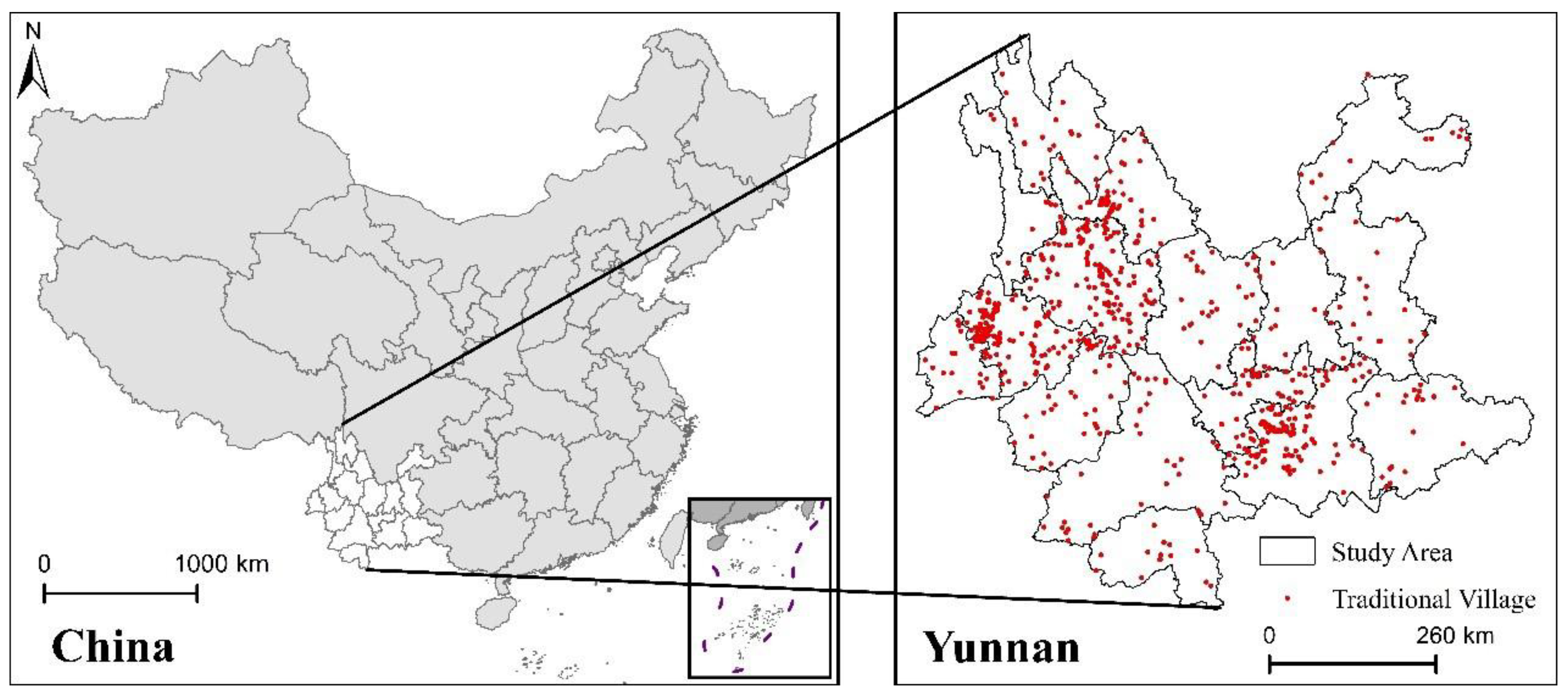
3.1. Study Area

Located in the southwest of China, Yunnan Province has a dense distribution of traditional villages, a rich total cultural heritage, and a large population of ethnic minorities, which is typical in terms of culture and traditional ethnicity (Figure 1). As of March 2023, the number of traditional villages in Yunnan Province ranks first among Chinese provinces and cities, covering 16 states (cities) and 24 ethnic groups, which is unique in China. Chinese traditional villages in Yunnan Province occupy an important position in the country due to their beautiful natural scenery, diversified ethnic culture, good ecological environment, and unique frontier flavor. In terms of ethnic types, the number of traditional villages by ethnic type is basically consistent with the proportion of ethnic composition in Yunnan, and 23 of the 25 hereditary ethnic groups with settlements in Yunnan have representative traditional Chinese villages. Among them, the earliest formation period of traditional villages in Yunnan Province can be traced back to China’s Tang Dynasty (618–907 A.D.), and since then, traditional villages of different cultures have been formed in different periods, which express the ancient Chinese culture of different periods, and are an important carrier for the study of ancient Chinese culture (China’s Tang, Song, Yuan, Ming, Qing, and Republican periods have all formed different traditional villages).
These traditional villages have excellent ecological environments, distinctive residential buildings, and well-preserved folk culture, demonstrating the local characteristics and ethnic charm of Yunnan. They also serve as important sources for studying the characteristics of traditional villages in China [53]; therefore, it is very representative to choose traditional villages in Yunnan Province for systematic study. Although Yunnan Province actively promotes the protection of traditional villages and the appropriate use of tourism, and the protection and development of traditional villages have achieved remarkable results in recent years, there are still various problems, mainly due to the uniqueness of each traditional village. Therefore, to address this issue, we analyze the spatial distribution characteristics and spatial vitality of traditional villages in Yunnan Province and summarize the development models for traditional villages in Yunnan.

3.2. Study Data

In order to better study the spatial distribution characteristics and spatial vitality of traditional villages in Yunnan Province, we select corresponding study datasets for different study contents. The dataset for analyzing traditional villages comes from the Chinese government website. The dataset for analyzing the spatial vitality of traditional villages comes from social media, where the generation of data is limited to traditional villages in Yunnan Province to avoid interference of data from other regions. The specific data are analyzed as described in the following sections.

3.2.1. Spatial Distribution Dataset of Traditional Villages

The data on traditional villages is sourced from a list of 6819 Chinese traditional villages selected from 2012 to 2022, publicly available on the website of the Ministry of Housing and Urban–Rural Development of the People’s Republic of China, of which the number of traditional villages in Yunnan Province is 708. In order to geographically locate these 708 traditional villages in Yunnan, we extract the spatial locations of the traditional villages using their spatial coordinates and Google Earth image maps, using village name prompts and the geometric center of the village graphics as the basis, and the roof images of ancient buildings as the auxiliary judgment materials. In cases where village information is lacking on maps and imagery, their locations are shifted to their respective town-level administrative centers. Using this method, we obtained a spatial distribution dataset of 708 traditional villages in Yunnan Province. To visualize these data more effectively, we sample the spatial datasets into a grid with a resolution of 1 km.

3.2.2. Sina Weibo Sign-In Data

Currently, China’s social media include Sina Weibo, Zhihu, Toutiao, Baidu Tieba, etc. Among them, Sina Weibo, which launched in China in 2009, is the earliest mainstream social media in China. By the end of 2022, the number of stable active users reached 586 million, ranking first among mainstream social media in China, while the number of Chinese mobile Internet users was 1.029 billion. Therefore, we choose Sina Weibo as the source of social media data, which has a representative and dominant advantage that other data cannot match.
Sina Weibo sign-in data refers to the sign-in information posted by users on the Sina Weibo app at specific locations. By analyzing the content of Sina Weibo sign-in data, we can determine the emotional attachment of users to sign-in areas, which reflects the vitality of different traditional villages [54]. To avoid significant fluctuations in the volume of Sina Weibo sign-in data over different periods, we select sign-in data from the past year as an indicator of the vitality of traditional villages in Yunnan Province. Using the Sina Weibo API, we obtained all the sign-in data in Yunnan Province from September 2022 to June 2023, with a total of 10.6923 million records. The data attributes include geographical coordinates, sign-in locations, Weibo links, user profile links, text content, image/video links, publication time, repost count, comment count, likes count, and number of followers. To better distinguish the Weibo sign-in data related to traditional villages, it was necessary to clean and filter the data. Firstly, we set filtering conditions to select sign-in data related to the 708 traditional villages, considering both the sign-in location and the text content of Weibo posts. Secondly, we clean the data by accessing the user’s location using the Sina Weibo profile link, then we remove data where the user’s location duplicates the position of traditional villages. In the end, we obtained a total of 50,900 records of Weibo sign-in data. By analyzing the cleaned data, we can gain a more comprehensive understanding of the vitality levels among different traditional villages in Yunnan.
It is worth noting that Sina Weibo data also has some limitations. From the tourists’ point of view, with the progress of globalization, although data from overseas tourists also continue to increase, certain social media platforms, especially Sina Weibo, are not used by overseas tourists, which means that our analysis of tourists on social media has some errors. Therefore, we compared and analyzed the number of overseas tourists and domestic tourists in Yunnan and found that in 2022, although the number of tourists in Yunnan reached more than 800 million, the number of overseas tourists who traveled to China during this period was only 0.8 billion due to China’s recent liberalization of its epidemic policy. However, only a small part of the 80 million tourists visited Yunnan Province, which means that the number of overseas tourists in Yunnan Province accounted for less than 1% of the total number of tourists. Therefore, we believe that the use of Sina Weibo social media will not cause a large deviation in the results.

3.3. Methods

3.3.1. Kernel Density Analysis

Kernel density estimation is a non-parametric estimation method for spatial analysis of point elements. Kernel density estimation refers to the estimation of density variation in point distributions using a moving unit, capturing the patterns of point elements and illustrating the spatial aggregation of their distribution. Currently, kernel density analysis is widely used in studies to represent the agglomeration degree of different phenomena in geographic space [55].
p i = 1 n π R 2 × j = 1 n k j 1 D i j 2 R 2 2
where  p i  is the kernel density value of the spatial position,  D i j  is the distance between the spatial point  i  and the study object j, n is the distance less than or equal to the spatial position to  D i j k j  is the spatial weight, and R is the search radius. The geometric meaning of kernel density analysis is that the density value is the highest in each core, and the increase in spatial distance will lead to a decrease in density until the kernel density value is 0. In addition, a different search radius will lead to different results when using kernel density analysis.
We used the default research radius computed for the dataset using the spatial variant of Silverman’s Rule of Thumb (Equation (2)):
R = 0.9 × min S D , D m × 1 ln 2   × n 0.2
where  n  is the count of input points,  D m  is the median of the distance from the mean center, and  S D  is the standard distance.

3.3.2. Anselin Local Moran’s I

Moran’s I is a commonly used method to reflect spatial autocorrelation. Moran’s I consists of Global Moran’s I and Anselin Local Moran’s I (LMI). The former generally reflects the spatial autocorrelation characteristics of spatial computation units, while the latter indicates the degree of autocorrelation between individual units and other spatial units and can represent the relationship between variables and neighboring variables [56]. It has been shown that local spatial autocorrelation is one of the most prevalent methods for investigating the existence of relationships in space, with advantages such as high accuracy and easy interpretation of results [57]. Therefore, in this study, LMI is used to detect the relationship between the spatial distribution of traditional villages and their spatial vitality. The formula for LMI is:
I i = x i x ¯ S 2 i j = 1 ,   j i n w i j ( x i x ¯ )
In the equation,  I i  is the statistical count of LMI for point  i w i j  is the spatial weight matrix,  x i  is the attribute value of point  i x ¯  is the mean value of all attribute values, and  S i 2  is the total sample variance.
S i 2 = j = 1 , j i n x i x ¯ 2 n 1
The spatial weight matrix  w i j  is normalized as follows:
i = 1 n j i n w i j = n
Introducing the  Z  score to represent the statistical values with similar values in  I i :
Z I i = I i E I i V a r I i
where, the formula of  E I i  is:
E I i = j = 1 , j i n w i j n 1
V a r I i = E I 2 i E I i 2
A high positive Z score (greater than 1.96) indicates that a statistically significant (0.05 level) outlier is obtained, and the aggregation of these high scores is denoted as the high–high region, i.e., there is a strong correlation. The principle of LMI is to measure the spatial association between spatial units and other units. When all the high-score spatial units cluster together, it is referred to as HH area.

4. Results

4.1. Spatial Distribution Characteristics of Traditional Villages

The 708 traditional villages in Yunnan were analyzed using kernel density analysis to obtain the spatial distribution of traditional villages in Yunnan Province, as shown in Figure 2. As can be seen from Figure 2, the high density of traditional villages is mainly concentrated in the area with Baoshan, Dali, Lijiang, and Honghe as the core, while the density is lower in other prefectures. From the point of view of different density cores, Baoshan has the highest density, and based on the data on traditional villages and the number of ethnic minorities, Baoshan has 13 ethnic minorities, and most of them are hereditary, making the distribution of traditional villages in Baoshan relatively concentrated. Dali and Lijiang also have relatively high-density values, which is because Dali and Lijiang are famous tourist cities in Yunnan Province, attracting more than half of the tourists in the province. The influx of a large number of tourists makes the local governments more active in the exploration and development of traditional villages to attract more visitors. Honghe also has a higher density value because it is one of the few prefectures in Yunnan Province where the number of ethnic minorities exceeds that of the Han ethnic group, and it is also an area with a high level of tourism development, similar to Dali and Lijiang.
Overall, the spatial distribution of traditional villages in Yunnan Province exhibits significant variations. These differences are not only influenced by the uneven geographical distribution but also by the degree of ethnic residency and development in different regions, as evident from our study results.

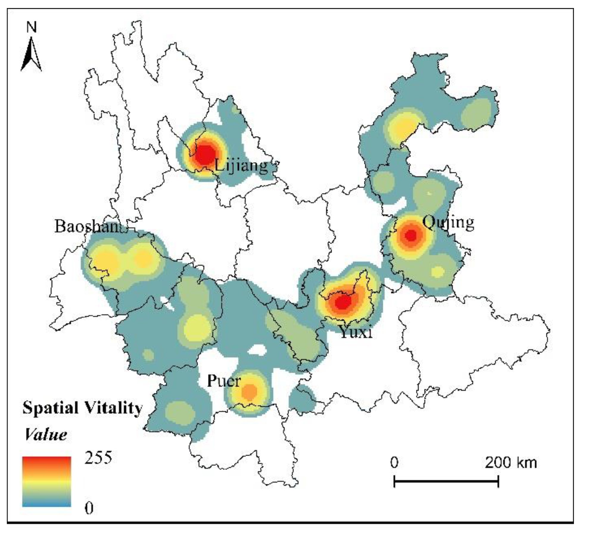
4.2. Assessment of Spatial Vitality of Traditional Villages

Spatial vitality can generally be represented by the attributes of a specific spatial element. For example, economic vitality can be indicated by nighttime lighting, while the spatial distribution of the population can represent urban vitality. However, in existing traditional villages, relevant economic and population attribute information is often limited, which means that the elements used to express urban spatial vitality may not necessarily be applicable to traditional villages. Therefore, in this study, a creative approach is used to unify and reflect the spatial vitality between different traditional villages by utilizing the relationship between the volume of Weibo sign-in data and positive evaluations. As shown in Figure 3, the spatial vitality cores of traditional villages in Yunnan Province are mainly distributed in Lijiang, Yuxi, Qujing, Pu’er, and Honghe, while the density of spatial vitality in other regions is lower. In terms of the density cores of spatial vitality, Lijiang has the highest spatial vitality density, followed by Yuxi and Qujing, while Pu’er and Baoshan have lower spatial vitality. In terms of the spatial vitality cores, the density distribution of vitality cores is significantly different from the density distribution of traditional villages, which is manifested in the fact that a high density of traditional villages is mainly distributed in Dali, Lijiang, Baoshan, and Honghe, while the areas with high spatial vitality are more concentrated in Yuxi, Qujing, and Pu’er. From the point of view of these areas, it can be found that although Pu’er has fewer traditional villages, the characteristics expressed by these traditional villages, such as Pu’er tea, attract a large number of external tourists and thus enhance the spatial vitality of traditional villages in the region. Yuxi and Qujing, due to their geographical proximity to Kunming, the main tourist destinations in Yunnan Province, could further enhance the spatial vitality of traditional villages in these two cities through the concentration of a large number of foreign tourists.

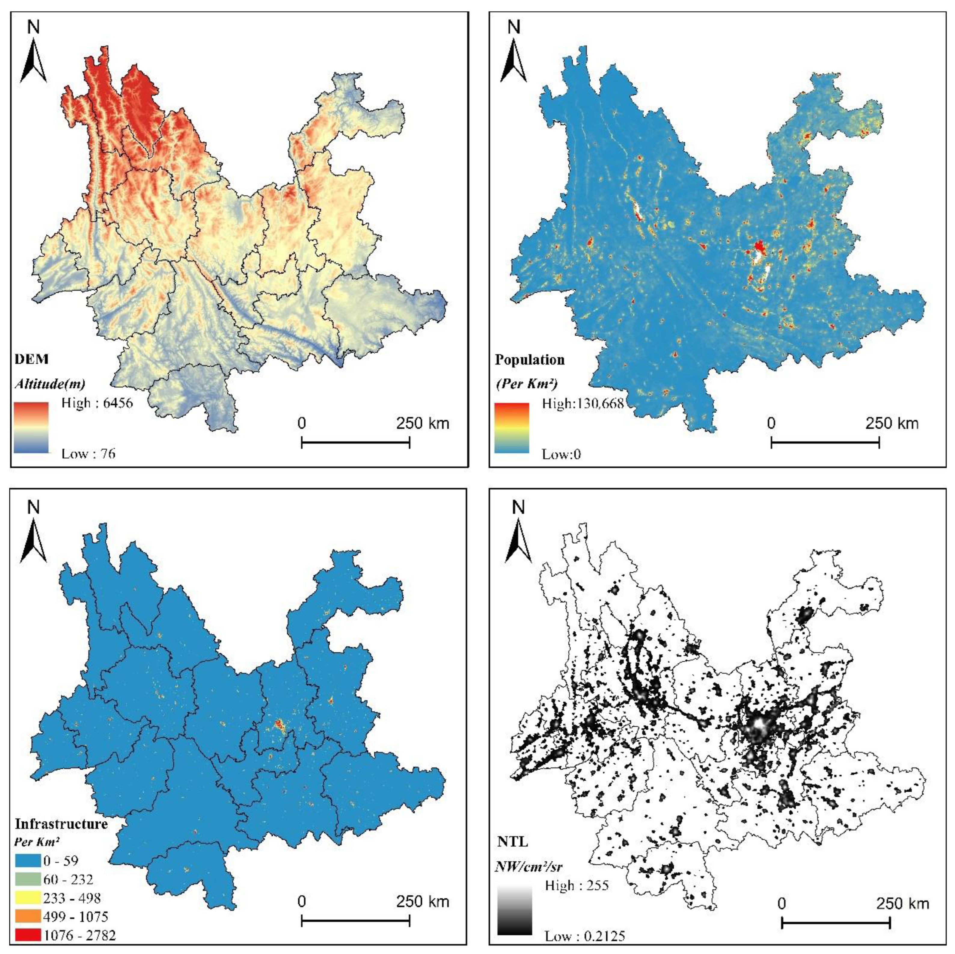
4.3. Spatial Correlation Analysis

In this study, we found that there is an obvious difference between the spatial distribution characteristics of traditional villages and the spatial vitality of traditional villages. Therefore, in order to better analyze the inherent manifestation of this difference and put forward differentiated development suggestions for different traditional villages, we spatially analyze the spatial distribution characteristics of different traditional villages and their relationship with spatial vitality. From the perspective of spatial distribution and spatial vitality of traditional villages, there is a certain spatial correlation between the two, which is not a simple clustering relationship because regions with high spatial distribution density are not necessarily regions with high spatial vitality. On the contrary, regions with low spatial distribution density may have high spatial vitality distribution. Therefore, in order to better represent such spatial correlation, we use local spatial autocorrelation to represent the clustering relationship. In terms of spatial relationships, we identify four clustering relationships, namely, HH, HL, LH, and LL, where HH represents traditional villages with high distribution density and high spatial vitality, HL represents traditional villages with high distribution density and low spatial vitality, LH represents traditional villages with low distribution density and high spatial vitality, and LL represents traditional villages with low distribution density and low spatial vitality. These four relationships cover the links between current spatial distribution characteristics and spatial vitality. Figure 4 shows the correlation between spatial distribution and spatial vitality of traditional villages, in which the HH clustering is mainly distributed in Dali and Lijiang, the HL clustering is mainly distributed in Baoshan, the LH clustering is mainly distributed in Qujing, Yuxi, and Pu’er, and the LL clustering is mainly distributed in the neighboring regions, such as Honghe. Using the distribution of different clusters, we summarize the traditional villages in Yunnan into four types, which are the vigorous development type (HH), potential development type (HL), stable development type (LH), and underdevelopment type (LL).
In order to better analyze the manifestation between the distribution characteristics of traditional villages and spatial vitality in Yunnan, we further compare the obtained spatial associations spatially with the geographic environment, ethnic population distribution, economic development, transportation, infrastructural development, and topography of Yunnan Province, with the aim of discovering the intrinsic mechanism underlying such spatial associations. Located in the inland region of China, Yunnan Province as a whole is dominated by plateaus and mountains, and the enclosed or semi-enclosed three-dimensional landscapes of mountains, rivers, and flat dams divide the province into relatively closed and independent residential areas [58]. The overall topography of Yunnan slopes higher in the west and lower in the east, with the north being higher than the south, presenting a step-like descending pattern. The spatial clustering relationship also shows that the HH and HL clusters are predominantly found in regions with relatively gentle slopes (Figure 5).
The distribution pattern of traditional villages is closely related to the distribution and development pattern of regional populations, especially the distribution of ethnic populations. At the end of 2020, Yunnan had a total of 16.309 million ethnic minority people, accounting for 33.60% of the province’s population. Ethnic minorities are distributed in all prefectures, counties, and cities, which has led to the formation of numerous settlements with a certain scale that can showcase their customs and ethnic culture [59,60]. The spatial distribution of these settlements is also influenced to some extent by the regional sense of ethnic identity, making it easier to form existing traditional villages. We also found that the distribution of LL and HL clustering is concentrated in areas with a higher concentration of ethnic minority populations, such as Baoshan.
The development level of transportation and infrastructure allows a central city to wield a radiating effect on the development of surrounding areas and traditional villages. With significant advantages in economic activities and resource allocation, a central city exerts a certain driving force on its peripheral cities and the entire regional economy. This effect is manifested as a greater degree of urbanization and more development opportunities as the distance from the central city decreases, as seen in the distribution of HH clustering in places like Dali and Lijiang [61]. However, previous studies have also found that the development brought about by the central city may have a certain impact on the preservation of traditional cultural heritage. In such cases, cities farther away from the central city may retain more traditional villages [62], such as Baoshan and Honghe. Therefore, we can see that most of the traditional villages in Yunnan are distributed in areas moderately far away from the central city. With little radiation from the central city and inconvenient transportation, their cultures undergo a strong isolation mechanism, which allows them to preserve their national cultures in a more complete way. Meanwhile, these traditional villages avoid the situation of lacking sustained development vitality and rapid decline due to being too far from the city.
Regarding the level of economic development, the economic level of traditional village areas is generally lower than that of other urban areas because traditional villages are mainly located in remote areas where it is more difficult to develop the land. The lower economic capacity means that villagers are incapable of developing and renewing the traditional villages in which they live, which, to some extent, further reduces the impact of the modern urban elements on the traditional villages [63]. Additionally, the closed geographic environment blocks economic and cultural exchanges between regions. This result is consistent with our finding that some LH clustering results exist around Kunming.

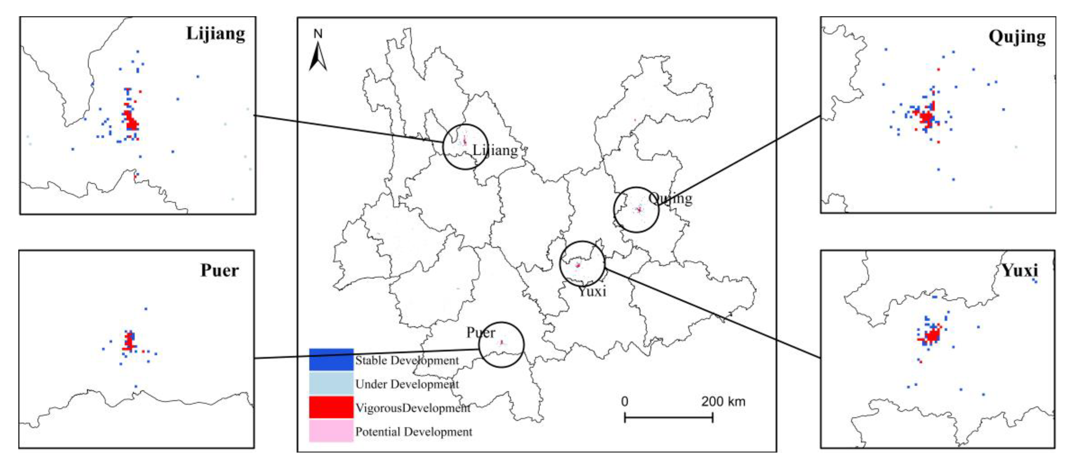
4.4. Classification and Development Recommendations for Traditional Villages in Yunnan Province

Combining the results of this study with the spatial clustering relationship, it can be found that it is necessary to develop differentiated strategies for the diverse characteristics of traditional villages in Yunnan. Among them, the vigorous development type (HH) traditional villages, which are characterized by both high distribution density and high spatial vitality, should be prioritized as focal villages for tourism development and regional investment. This means that the dynamic optimization and upgrading of the village layout should be continuously promoted on the basis of strict protection in order to enhance the spatial quality of traditional villages. Consideration can be given to leveraging the excellent tourism resources of Dali and Lijiang to create traditional villages with regional influence and to explore the formation of a cooperative network among the surrounding villages, thus establishing exemplary high-quality traditional villages.
The potential development type (HL) traditional villages, which are characterized by high distribution density but low spatial vitality, should be promoted jointly for protection and be inherited and developed, that is, on the basis of ensuring proper protection, a comprehensive living service system should be established. Further exploration can be conducted to create immersive cultural experience scenes, artistic performances of traditional stories, development of distinctive local cuisine, revitalization of traditional intangible cultural heritage, and cultivation of high-end characteristic homestays with an aim to enhance the cultural experience of traditional villages and the comprehensive attractiveness of the traditional villages.
The stable development type (LH) traditional villages, which are characterized by low distribution density but high spatial vitality, should consider protection as the core. That is, on the basis of protection, distinctive cultural display spaces and characteristic landscape spaces should be created to cultivate a cultural atmosphere that can transform cultural value into socioeconomic benefits. While increasing government investment and attracting capital, it is essential to note that the development of these traditional villages should not prioritize scale but rather focus on enhancing quality and creating a high-end tourist experience.
The underdevelopment type (LL) is characterized by low distribution density and low spatial vitality. In these traditional villages, agriculture should serve as the foundation for strengthening the cultivation of specialty agricultural products. Simultaneously, efforts should be made to improve village environments, enhance infrastructure, and upgrade public service facilities to enhance the rural landscape. Similarly, it is important to note that while developing tourism resources in these traditional villages, priority should be given to maintaining the authenticity of the local culture and avoiding excessive and indiscriminate large-scale development.
The results obtained in this study echo the three questions we mentioned earlier, where the first part of the results addresses our first question, that is, the spatial distribution characteristics of traditional villages in Yunnan Province. The second part of the results addresses the second question, which reflects the development characteristics of traditional villages using their spatial vitality. The third part of the results addresses the third question, which analyzes in detail the connection between the spatial distribution characteristics of traditional villages and their spatial vitality. In the fourth part of the results, a differentiated reflection on the development of traditional villages is presented based on the results of the third part, which further addresses the significance and purpose of this study.

5. Discussion

At present, the spatial vitality of traditional villages is generally low, and we believe there are some macro reasons for this. First, during the rapid urbanization process in China, the material, resources, and wealth of rural areas have been increasingly concentrated in urban areas, leading to a pattern of polarization between urban and rural areas, which has resulted in the hollowing out of traditional villages [64,65]. Second, in the rapid process of urbanization, a large number of rural laborers have migrated to urban areas, leading to a continuous decline in traditional agriculture and rural areas and a severe shortage in human resources have hindered the inheritance of traditional culture, thereby limiting the development of spatial vitality in traditional villages [66,67,68]. Third, there exists a contradiction between the protection and development of traditional villages. As a part of tourism resources, commercial tourism development can improve the economic level of traditional villages in the region [69]. However, blind development can lead to an influx of external tourists, causing certain impacts and damages to the rustic natural and cultural landscapes in the villages [70], and the original ecological natural landscape value and cultural value in traditional villages may also disappear with the impact of commercial tourism [71]. Therefore, it is particularly important to objectively assess the spatial vitality of traditional villages under current circumstances and propose differentiated development strategies. Therefore, this study identifies the spatial vitality of different traditional villages based on the Sina Weibo sign-in data. This type of visitor-based objective evaluation often provides more accurate expressions of the spatial vitality of traditional villages, which makes our development recommendations for different types of traditional villages based on the results of the study more objective.
Regarding assessments of the development and vitality of traditional villages, previous studies generally use traditional villages’ population, employment, economic, and other related indices to discriminate [72]. This evaluation method has certain shortcomings, for example, it cannot highlight individual differences between traditional villages. Furthermore, in traditional villages, the relevant information on the economic and demographic attributes is weaker, making the development recommendations less targeted [73,74]. In this regard, it is more valuable to assess the development and vitality of traditional villages based on an assessment of their characteristics. This study starts by obtaining social media data and then discriminates the spatial vitality of traditional villages based on Weibo sign-in data and analyzes the differences in spatial vitality in a more obvious way.
Regarding the actual development of traditional villages, most of the development trends in traditional villages are consistent, that is, the development of rural tourism is the main form. This is because the development mode analyzed in the past is more about how to improve the economic level and population scale [75]. However, this development pattern has limited effects on the development of traditional villages and can even cause damage. Moreover, certain traditional villages in Yunnan Province are more different from each other due to different geographic environments and national cultures, resulting in a single development model that not only does not necessarily conform to the development of traditional villages. This will also damage the protection of traditional villages, and as for the spatial vitality effect, it is even worse. Therefore, based on the relationship between spatial distribution characteristics and the spatial vitality of traditional villages, this study divides traditional villages into four types and puts forward feasible recommendations for the development of different types of traditional villages, which is of great significance and value to the development and spatial quality of traditional villages.
For the future development of traditional villages in Yunnan Province, static cultural scenes should be created first to create a unique spatial cultural atmosphere. Second, dynamic cultural projects should be enriched to promote the integration of village business, and the management concept should be updated to realize the revitalization and utilization of public historical buildings in the villages. Finally, the quality of the spatial environment should be upgraded to increase spatial attraction.
Starting from the differentiated development of traditional villages in Yunnan, this study analyzes in detail the spatial distribution characteristics and spatial vitality of traditional villages as well as the relationship between the two, respectively. In assessing the spatial vitality of traditional villages, a simple and generalizable method is proposed to reflect their spatial vitality based on the number of foreign populations and the evaluation of traditional villages. Based on the relationship between the spatial vitality of traditional villages and their spatial distribution characteristics, different types of traditional villages are summarized, and finally, differentiated development ideas are proposed. These ideas provide feasible references for the sustainable development of traditional villages and have positive significance for the development of traditional villages in other regions and the planning of rural revitalization.
This study focuses on analyzing the spatial distribution characteristics and spatial vitality of traditional villages in Yunnan Province and provides development recommendations for different types of traditional villages. However, this study still has certain limitations. First, in terms of study data, the Weibo sign-in data used in this study may not fully reflect the spatial vitality of traditional villages, which is because Weibo is more popular among the younger generation who may not have the same level of interest in traditional villages compared with the middle-aged and elderly population. Therefore, the analysis of spatial vitality is only a true reflection of the data level. Second, the classification and development of traditional villages should also take into account the different situations of indigenous populations in different regions, especially considering the significant differences in the living habits of different ethnic minorities in Yunnan Province. Therefore, it is necessary to provide development recommendations based on the characteristics of ethnic minorities, which will be a topic of our ongoing study.

6. Conclusions

Enhancing the spatial vitality of traditional villages and proposing targeted strategies for differentiated development are important paths for the conservation and improvement of spatial quality of traditional villages. This study starts from the spatial distribution characteristics of traditional villages, evaluates the spatial vitality of traditional villages using Weibo sign-in data, and focuses on analyzing the relationship between the spatial distribution characteristics and spatial vitality of traditional villages. Finally, this study puts forward development strategies for different traditional villages to provide spatial vitality to the greatest extent, which is of great value for the protection and sustainable development of traditional villages in Yunnan. At the same time, it also has positive significance for the implementation of the rural revitalization plan in Yunnan Province. Additionally, although this study focuses on Yunnan Province as a case study, the study methods and findings can be applied to other cities, providing feasible approaches for the conservation and differentiated development of traditional villages in China.

Author Contributions

Conceptualization, R.Z.; methodology, J.Z. and R.Z.; software, X.Z.; validation, J.Z.; formal analysis, X.Z.; investigation, J.Z. and R.Z.; data curation, X.H.; writing—original draft, J.Z. and X.H.; writing—review and editing, J.Z., Q.L. and R.Z. All authors have read and agreed to the published version of the manuscript.

Funding

This research received no external funding.

Data Availability Statement

The data presented in this study are publicly available data sources stated in the citation. Please contact the corresponding author regarding data availability.

Acknowledgments

Thanks to all editors and reviewers.

Conflicts of Interest

The authors declare no conflict of interest.

References

  1. Wang, X.; Zhu, Q. Influencing Factors of Traditional Village Protection and Development from the Perspective of Resilience Theory. Land 2022, 11, 2314. [Google Scholar] [CrossRef]
  2. Li, X.; Wang, Z.H.; Xia, B.; Chen, S.C.; Chen, S. Testing the associations between quality-based factors and their impacts on historic village tourism. Tour. Manag. Perspect. 2019, 32, 100573. [Google Scholar] [CrossRef]
  3. Wu, W.; Wang, J. Gentrification effects of China’s urban village renewals. Urban Stud. 2017, 54, 214–229. [Google Scholar] [CrossRef]
  4. Ma, H.; Tong, Y. Spatial differentiation of traditional villages using ArcGIS and GeoDa: A case study of Southwest China. Ecol. Inform. 2022, 68, 101416. [Google Scholar] [CrossRef]
  5. Xu, L.; Liu, K.; Sang, K.; Lin, G.; Luo, Q.; Huang, C.; Giordano, A. Assessment of the Exterior Quality of Traditional Residences: A Genetic Algorithm–Backpropagation Approach. Buildings 2022, 12, 559. [Google Scholar] [CrossRef]
  6. Chen, X.; Xie, W.; Li, H. The spatial evolution process, characteristics and driving factors of traditional villages from the perspective of the cultural ecosystem: A case study of Chengkan Village. Habitat Int. 2020, 104, 102250. [Google Scholar] [CrossRef]
  7. Wang, Y.P.; Wang, Y.; Wu, J. Urbanization and informal development in China: Urban villages in Shenzhen. Int. J. Urban Reg. Res. 2009, 33, 957–973. [Google Scholar] [CrossRef]
  8. Álvarez-Berríos, N.L.; Parés-Ramos, I.K.; Aide, T.M. Contrasting patterns of urban expansion in Colombia, Ecuador, Peru, and Bolivia between 1992 and 2009. Ambio 2013, 42, 29–40. [Google Scholar] [CrossRef]
  9. Liu, Y.; He, S.; Wu, F.; Webster, C. Urban villages under China’s rapid urbanization: Unregulated assets and transitional neighbourhoods. Habitat Int. 2010, 34, 135–144. [Google Scholar] [CrossRef]
  10. Chen, X. The core of China’s rural revitalization: Exerting the functions of rural area. China Agric. Econ. Rev. 2020, 12, 1–13. [Google Scholar] [CrossRef]
  11. Yang, J.; Xu, C.; Fang, Z.; Shi, Y. Spatial Distribution Characteristics and Driving Factors of Rural Revitalization Model Villages in the Yangtze River Delta. Land 2022, 11, 1935. [Google Scholar] [CrossRef]
  12. Liu, S.; Ge, J.; Bai, M.; Yao, M.; He, L.; Chen, M. Toward classification-based sustainable revitalization: Assessing the vitality of traditional villages. Land Use Policy 2022, 116, 106060. [Google Scholar] [CrossRef]
  13. Ma, W.; Jiang, G.; Zhou, T.; Zhang, R. Mixed land uses and community decline: Opportunities and challenges for mitigating residential vacancy in peri-urban villages of China. Front. Environ. Sci. 2022, 10, 887988. [Google Scholar] [CrossRef]
  14. Zhao, M.; Wang, L.; Fu, Q.; Wang, Y.; Zhang, D. Promoting living space protection while ensuring sustainable tourism in Yuhu Village, Lijiang City. Int. J. Sustain. Dev. World Ecol. 2011, 18, 553–558. [Google Scholar] [CrossRef]
  15. Persson, J.; Ford, S.; Keophoxay, A.; Mertz, O.; Nielsen, J.Ø.; Vongvisouk, T.; Zörner, M. Large differences in livelihood responses and outcomes to increased conservation enforcement in a protected area. Hum. Ecol. 2021, 49, 597–616. [Google Scholar] [CrossRef]
  16. Kochan, D. Placing the urban village: A spatial perspective on the development process of urban villages in contemporary China. Int. J. Urban Reg. Res. 2015, 39, 927–947. [Google Scholar] [CrossRef]
  17. Wang, Y.; Liang, C.; Li, J. Detecting village-level regional development differences: A GIS and HLM method. Growth Chang. 2019, 50, 222–246. [Google Scholar] [CrossRef]
  18. Wang, W.; Shi, Y.; Zhang, J.; Hu, L.; Li, S.; He, D.; Liu, F. Traditional Village Building Extraction Based on Improved Mask R-CNN: A Case Study of Beijing, China. Remote Sens. 2023, 15, 2616. [Google Scholar] [CrossRef]
  19. Zhao, M.; Liang, J.; Lu, S. Cultural Connotation and Image Dissemination of Ancient Villages under the Environment of Ecological Civilization: A Case Study of Huizhou Ancient Villages. J. Environ. Public Health 2022, 2022, 7401144. [Google Scholar] [CrossRef]
  20. Mattouk, M.; Talhouk, S.N. A content analysis of nature photographs taken by Lebanese rural youth. PLoS ONE 2017, 12, e0177079. [Google Scholar] [CrossRef]
  21. Xu, J.; Yang, M.; Hou, C.; Lu, Z.; Liu, D. Distribution of rural tourism development in geographical space: A case study of 323 traditional villages in Shaanxi, China. Eur. J. Remote Sens. 2021, 54 (Suppl. 2), 318–333. [Google Scholar] [CrossRef]
  22. Mariën, J.; Lo Iacono, G.; Rieger, T.; Magassouba, N.; Günther, S.; Fichet-Calvet, E. Households as hotspots of Lassa fever? Assessing the spatial distribution of Lassa virus-infected rodents in rural villages of Guinea. Emerg. Microbes Infect. 2020, 9, 1055–1064. [Google Scholar] [CrossRef] [PubMed]
  23. Wong, H.L.; Wang, Y.; Luo, R.; Zhang, L.; Rozelle, S. Local governance and the quality of local infrastructure: Evidence from village road projects in rural China. J. Public Econ. 2017, 152, 119–132. [Google Scholar] [CrossRef]
  24. Zikirya, B.; He, X.; Li, M.; Zhou, C. Urban food takeaway vitality: A new technique to assess urban vitality. Int. J. Environ. Res. Public Health 2021, 18, 3578. [Google Scholar] [CrossRef] [PubMed]
  25. Zhou, Y.; He, X.; Zikirya, B. Boba Shop, Coffee Shop, and Urban Vitality and Development—A Spatial Association and Temporal Analysis of Major Cities in China from the Standpoint of Nighttime Light. Remote Sens. 2023, 15, 903. [Google Scholar] [CrossRef]
  26. Sipple, J.W.; Francis, J.D.; Fiduccia, P.C. Exploring the gradient: The economic benefits of ‘nearby’ schools on rural communities. J. Rural Stud. 2019, 68, 251–263. [Google Scholar] [CrossRef]
  27. Roux, E.; de Fátima VenÃ, A.; Girres, J.F.; Romaña, C.A. Spatial patterns and eco-epidemiological systems-Part I: Multi-scale spatial modelling of the occurrence of Chagas disease insect vectors. Geospat. Health 2011, 6, 41–51. [Google Scholar] [CrossRef]
  28. Tsai, L.L. Understanding the falsification of village income statistics. China Q. 2008, 196, 805–826. [Google Scholar] [CrossRef]
  29. Singogo, E.; Kanike, E.; Van Lettow, M.; Cataldo, F.; Zachariah, R.; Bissell, K.; Harries, A.D. Village registers for vital registration in rural Malawi. Trop. Med. Int. Health 2013, 18, 1021–1024. [Google Scholar] [CrossRef]
  30. Arslan, F.; Değirmenci, H.; Kartal, S. Kernel Density Analysis of Parcel Size and Shapes Before and After Land Consolidation: A Case Study from Aşağısümenli Village in Malatya, Turkey. J. Agric. Sci. 2020, 26, 388–394. [Google Scholar] [CrossRef]
  31. Li, M.; Ouyang, W.; Zhang, D. Spatial Distribution Characteristics and Influencing Factors of Traditional Villages in Guangxi Zhuang Autonomous Region. Sustainability 2022, 15, 632. [Google Scholar] [CrossRef]
  32. Duan, Y.; Yan, L.; Lai, Z.; Chen, Q.; Sun, Y.; Zhang, L. The spatial form of traditional villages in Fuzhou area of Jiangxi Province determined via GIS methods. Front. Earth Sci. 2022, 16, 1–13. [Google Scholar] [CrossRef]
  33. Chen, W.; Yang, L.; Wu, J.; Wu, J.; Wang, G.; Bian, J.; Zeng, J.; Liu, Z. Spatio-temporal characteristics and influencing factors of traditional villages in the Yangtze River Basin: A Geodetector model. Herit. Sci. 2023, 11, 111. [Google Scholar] [CrossRef]
  34. Jia, A.; Liang, X.; Wen, X.; Yun, X.; Ren, L.; Yun, Y. GIS-Based Analysis of the Spatial Distribution and Influencing Factors of Traditional Villages in Hebei Province, China. Sustainability 2023, 15, 9089. [Google Scholar] [CrossRef]
  35. Cheng, G.; Li, Z.; Xia, S.; Gao, M.; Ye, M.; Shi, T. Research on the Spatial Sequence of Building Facades in Huizhou Regional Traditional Villages. Buildings 2023, 13, 174. [Google Scholar] [CrossRef]
  36. Lan, F.; Gong, X.; Da, H.; Wen, H. How do population inflow and social infrastructure affect urban vitality? Evidence from 35 large-and medium-sized cities in China. Cities 2020, 100, 102454. [Google Scholar] [CrossRef]
  37. Mouratidis, K.; Poortinga, W. Built environment, urban vitality and social cohesion: Do vibrant neighborhoods foster strong communities? Landsc. Urban Plan. 2020, 204, 103951. [Google Scholar] [CrossRef]
  38. Soszyński, D.; Sowińska-Świerkosz, B.; Kamiński, J.; Trzaskowska, E.; Gawryluk, A. Rural public places: Specificity and importance for the local community (case study of four villages). Eur. Plan. Stud. 2022, 30, 311–335. [Google Scholar] [CrossRef]
  39. Chion, M. Producing urban vitality: The case of dance in San Francisco. Urban Geogr. 2009, 30, 416–439. [Google Scholar] [CrossRef]
  40. Chen, Z.; Dong, B.; Pei, Q.; Zhang, Z. The impacts of urban vitality and urban density on innovation: Evidence from China’s Greater Bay Area. Habitat Int. 2022, 119, 102490. [Google Scholar] [CrossRef]
  41. Gao, C.; Hou, J.; Gong, J. Study on the symbiotic development path of traditional villages in the county based on the grey relation analysis: The case of Xunxian County in Henan, China. Grey Syst. Theory Appl. 2023, 13, 193–205. [Google Scholar] [CrossRef]
  42. Chen, J.; Wang, C.; Dai, R.; Xu, S.; Shen, Y.; Ji, M. Practical Village Planning Strategy of Different Types of Villages—A Case Study of 38 Villages in Shapingba District, Chongqing. Land 2021, 10, 1143. [Google Scholar] [CrossRef]
  43. Yang, Z.; Liu, T.; Shen, N.; Guan, M.; Zheng, Y.; Jiang, H. Resource and Environment Constraints and Promotion Strategies of Rural Vitality: An Empirical Analysis of Rural Revitalization Model Towns. Front. Environ. Sci. 2022, 10, 956644. [Google Scholar] [CrossRef]
  44. Li, H.; Jin, X.; Liu, J.; Feng, D.; Xu, W.; Zhou, Y. Analytical framework for integrating resources, morphology, and function of rural system resilience—An empirical study of 386 villages. J. Clean. Prod. 2022, 365, 132738. [Google Scholar] [CrossRef]
  45. Rao, Y.; Zou, Y.; Yi, C.; Luo, F.; Song, Y.; Wu, P. Optimization of rural settlements based on rural revitalization elements and rural residents’ social mobility: A case study of a township in western China. Habitat Int. 2023, 137, 102851. [Google Scholar] [CrossRef]
  46. Pan, W.; Du, J. Impacts of urban morphological characteristics on nocturnal outdoor lighting environment in cities: An empirical investigation in Shenzhen. Build. Environ. 2021, 192, 107587. [Google Scholar] [CrossRef]
  47. Gong, Y.; Ji, X.; Zhang, Y.; Cheng, S. Spatial Vitality Evaluation and Coupling Regulation Mechanism of a Complex Ecosystem in Lixiahe Plain Based on Multi-Source Data. Sustainability 2023, 15, 2141. [Google Scholar] [CrossRef]
  48. Xu, Y.; Chen, X. Quantitative analysis of spatial vitality and spatial characteristics of urban underground space (UUS) in metro area. Tunn. Undergr. Space Technol. 2021, 111, 103875. [Google Scholar] [CrossRef]
  49. Mu, H.; Kurozawa, Y.; Kotani, K.; Liu, G.; Liu, P.; Tsunekawa, A.; Nishino, S.; Ito, T.Y. Health-related quality of life and recognition of desertification among inhabitants of the Loess Plateau region of China: Findings for city and village communities. J. Environ. Health 2008, 70, 38–43. [Google Scholar]
  50. Jyotsna, J.H.; Maurya, U.K. Experiencing the real village—A netnographic examination of perceived authenticity in rural tourism consumption. Asia Pac. J. Tour. Res. 2019, 24, 750–762. [Google Scholar] [CrossRef]
  51. Lin, Y.; Shui, W.; Li, Z.; Huang, S.; Wu, K.; Sun, X.; Liang, J. Green space optimization for rural vitality: Insights for planning and policy. Land Use Policy 2021, 108, 105545. [Google Scholar] [CrossRef]
  52. Fuentes, L.; Miralles-Guasch, C.; Truffello, R.; Delclòs-Alió, X.; Flores, M.; Rodríguez, S. Santiago de Chile through the eyes of Jane Jacobs. Analysis of the conditions for urban vitality in a Latin American metropolis. Land 2020, 9, 498. [Google Scholar] [CrossRef]
  53. Jin, L.; Wang, Z.; Chen, X. Spatial distribution characteristics and influencing factors of traditional villages on the Tibetan plateau in China. Int. J. Environ. Res. Public Health 2022, 19, 13170. [Google Scholar] [CrossRef] [PubMed]
  54. Pan, C.; Zhou, J.; Huang, X. Impact of check-in data on urban vitality in the Macao Peninsula. Sci. Program. 2021, 2021, 7179965. [Google Scholar] [CrossRef]
  55. Ferrari, L. Discovering city dynamics through sports tracking applications. Computer 2011, 44, 63–68. [Google Scholar] [CrossRef]
  56. Anselin, L. Global Spatial Autocorrelation (2)- Geoda Documentation. 2019. Available online: https://geodacenter.github.io/workbook/5b_global_adv/lab5b.html#bivariate-moran-scatter-plot (accessed on 10 May 2023).
  57. He, X.; Zhang, R.; Yuan, X.; Cao, Y.; Zhou, C. The role of planning policy in the evolution of the spatial structure of the Guangzhou metropolitan area in China. Cities 2023, 137, 104284. [Google Scholar] [CrossRef]
  58. Xiaoli, C.; Qing, Z.; Chunguo, L. Distribution pattern of coseismic landslides triggered by the 2014 Ludian, Yunnan, China Mw6. 1 earthquake: Special controlling conditions of local topography. Landslides 2015, 12, 1159–1168. [Google Scholar] [CrossRef]
  59. Wang, H.F.; Chiou, S.C. Study on the sustainable development of human settlement space environment in traditional villages. Sustainability 2019, 11, 4186. [Google Scholar] [CrossRef]
  60. Fu, Y.; Brookfield, H.; Guo, H.; Chen, J.; Chen, A.; Cui, J. Smallholder rubber plantation expansion and its impact on local livelihoods, land use and agrobiodiversity, a case study from Daka, Xishuangbanna, southwestern China. Int. J. Sustain. Dev. World Ecol. 2009, 16, 22–29. [Google Scholar] [CrossRef]
  61. Chen, B.; Zhu, Y.; He, X.; Zhou, C. Analysis of High-Quality Tourism Destinations Based on Spatiotemporal Big Data—A Case Study of Urumqi. Land 2023, 12, 1425. [Google Scholar] [CrossRef]
  62. Byg, A.; Salick, J.; Law, W. Medicinal plant knowledge among lay people in five eastern Tibet villages. Hum. Ecol. 2010, 38, 177–191. [Google Scholar] [CrossRef]
  63. Vijulie, I.; Lequeux-Dincă, A.I.; Preda, M.; Mareci, A.; Matei, E.; Cuculici, R.; Taloș, A.M. Certeze Village: The Dilemma of traditional vs. post-modern architecture in Țara Oașului, Romania. Sustainability 2021, 13, 11180. [Google Scholar] [CrossRef]
  64. Zhou, C.; He, X.; Wu, R.; Zhang, G. Using Food Delivery Data to Identify Urban-Rural Areas: A Case Study of Guangzhou, China. Front. Earth Sci. 2022, 10, 860361. [Google Scholar] [CrossRef]
  65. He, X.; Zhu, Y.; Chang, P.; Zhou, C. Using tencent user location data to modify night-time light data for delineating urban agglomeration boundaries. Front. Environ. Sci. 2022, 10, 269. [Google Scholar] [CrossRef]
  66. Haartsen, T.; Gieling, J. Dealing with the loss of the village supermarket: The perceived effects two years after closure. Sociol. Rural 2021, 61, 561–577. [Google Scholar] [CrossRef]
  67. Peters, P.; Carson, D.; Porter, R.; Vuin, A.; Carson, D.; Ensign, P. My village is dying? Integrating methods from the inside out. Can. Rev. Sociol. Rev. Can. Sociol. 2018, 55, 451–475. [Google Scholar] [CrossRef]
  68. Wong, S.W.; Dai, Y.; Tang, B.S.; Liu, J. A new model of village urbanization? Coordinative governance of state-village relations in Guangzhou City, China. Land Use Policy 2021, 109, 105500. [Google Scholar] [CrossRef]
  69. Hua, L.; Yanmo, G. Research on the Protection and Tourism Development Strategy of the Traditional Village. Agro Food Ind. HI-Tech 2017, 28, 1127–1131. [Google Scholar]
  70. Wang, L.; Wen, C. Traditional villages in forest areas: Exploring the spatiotemporal dynamics of land use and landscape patterns in enshi prefecture, China. Forests 2021, 12, 65. [Google Scholar] [CrossRef]
  71. Sop Lee, H.; Nakai, Y. Effect of Floods on Village Spatial Structure and Hierarchy–Hahoe Village, Korea. Landsc. Res. 2015, 40, 411–436. [Google Scholar] [CrossRef]
  72. Hu, F.; Wu, S. Migration experience of village leaders and local economic development: Evidence from rural China. China World Econ. 2012, 20, 37–53. [Google Scholar] [CrossRef]
  73. Purnamawati, I.G.A.; Yuniarta, G.A.; Jie, F. Strengthening the role of corporate social responsibility in the dimensions of sustainable village economic development. Heliyon 2023, 9, e15115. [Google Scholar] [CrossRef]
  74. Yuan, C.; Jiang, M. Migration and Land Exploitation from Yuan to Qing Dynasties: Insights from 252 Traditional Villages in Hunan, China. Sustainability 2023, 15, 1001. [Google Scholar] [CrossRef]
  75. Yuan, W.; Li, J.; Liu, C.; Shang, R. How to Realize the Integration of Urbanization and Rural Village Renewal Strategies in Rural Areas: The Case Study of Laizhou, China. Land 2022, 11, 2161. [Google Scholar] [CrossRef]
Figure 1. Study area. Traditional villages in the study area include all villages formed from the earliest Tang Dynasty to the New China period.
Land 12 01663 g001
Figure 2. Spatial distribution of traditional villages in Yunnan Province. The spatial distribution is calculated using a kernel density analysis, where the color from dark to light indicates the density of traditional village distribution, i.e., the darker the color, the higher the density of traditional villages, and the lighter the color, the lower the density of traditional villages. Among the villages, Baoshan has the darkest color, indicating that the density of traditional villages in Baoshan is the highest, followed by Honghe, Lijiang, Dali, and other regions.
Land 12 01663 g002
Figure 3. Spatial vitality of traditional villages in Yunnan Province. The distribution results for spatial are indicated with colors, where the color from dark to light indicates high or low spatial vitality of traditional villages, i.e., the darker the color, the greater the spatial vitality of a traditional village, and the lighter the color, the lower the spatial vitality of a traditional village. Among the villages, Lijiang has the darkest color, indicating that the spatial vitality of traditional villages in Lijiang is the greatest, followed by Yuxi and other regions such as Qujing and Pu’er. Regarding the spatial distribution of traditional villages in Figure 2, both Figure 2 and Figure 3 indicate the density and vitality using color shades, respectively, i.e., the results of both analyses can be simply compared using the color shades of different areas.
Land 12 01663 g003
Figure 4. Spatial distribution and vitality correlation of traditional villages. Different colors represent the distribution of different types of traditional villages, and the four small figures show the distribution of the four types of traditional villages in Lijiang, Pu’er, Qujing, and Yuxi, respectively.
Land 12 01663 g004
Figure 5. Distribution of topography, population, infrastructure, and economic development in Yunnan Province. We use the density of transportation and infrastructure per square kilometer to indicate the state of infrastructure and nighttime light data to indicate the level of economic distribution.
Land 12 01663 g005
Disclaimer/Publisher’s Note: The statements, opinions and data contained in all publications are solely those of the individual author(s) and contributor(s) and not of MDPI and/or the editor(s). MDPI and/or the editor(s) disclaim responsibility for any injury to people or property resulting from any ideas, methods, instructions or products referred to in the content.

