Abstract
Mobility plays a critical role in promoting rural development. However, the current knowledge regarding the factors that influence mobility between rural towns is limited. The objective of this study is to explore the impact of administrative division and regional accessibility on rural mobility to inform development policies and strategies. The administrative division is demarcated by district and city boundaries, and regional accessibility is assessed using various modes of transportation, including cars, high-speed railways (HSRs), and intercity commuter railways (ICRs). A flow-based geographically weighted regression (FGWR) method is employed based on mobile phone signaling data to quantify the associations and identify the local effects of these factors in the Pearl River Delta (PRD). The findings suggest that both administrative division and regional accessibility significantly influence rural mobility. Specifically, the effects of district boundaries on commuting mobility are more pronounced in the central areas along the Pearl River, while the effects of city boundaries on non-commuting mobility between the core area and surrounding regions are more significant. With regard to regional accessibility, cars are the preferred mode of transportation for connections between the core areas of cities along the Pearl River, whereas HSR is favored more for non-commuting trips between the northwest and center regions. This study provides novel empirical insights into the understanding of rural mobility and has significant implications for promoting regional integration.
1. Introduction
The key objective of the World Bank’s rural transport and travel initiative is to promote rural sustainable development across the world [1]. Accordingly, the feature targets of the United Nations Sustainable Development Goals (SDGs) 2030 agenda aim to develop rural transport [2], which, largely owing to the population flows, has the potential to drive economic growth and enhance the living standards of rural communities, reducing the risk of social marginalization [3,4]. These efforts align with the overarching goals of the SDGs and underscore the importance of mobility as a component of sustainable development.
Rural mobility, which refers to the daily movement of the population between towns in rural areas in this study, plays a fundamental role in fostering social and economic outcomes and is closely related to poverty, low life quality, and social exclusion [5]. As such, it is necessary to investigate factors such as accessibility and administration. Accessibility can be defined as the potential for interaction opportunities and can be understood as “the advantages provided by a land use and transportation system” [6]. The difference in accessibility between highly urbanized areas and rural environments is noticeable. Although urban areas typically benefit from easy access to goods and services [7], rural areas often encounter challenges such as remote shopping centers and insufficient public transportation [8]. The limited availability of local resources for shopping, healthcare, and other essential needs in rural areas, resulting from factors such as long distances, poor traffic conditions, and a lack of job opportunities and services, can lead to poor regional accessibility [9,10]. In addition, the frequent movement between different spatial units, even across administrative boundaries, is becoming increasingly prevalent in rural areas for work, leisure, and tourism [11,12]. The improvement in transport infrastructure, such as the expansion of high-speed railways and village-to-village road projects, has significantly advanced regional accessibility and stimulated population movement across administrative divisions. In fact, administrative division estimates the differences in terms of institutions and management, and it matters if they are a part of the same administrative division [13]. As a result, it is essential to examine the impact of administrative division and regional accessibility on rural mobility, as this knowledge can provide valuable insights for policy interventions aimed at promoting rural development.
There is growing interest in mobility, with a shift in focus from urban to rural areas at various scales. From a research perspective, studies have utilized individual-level data based on various spatial units, such as sub-district, census tract, traffic analysis zone, and 100–500 m buffer levels, to shed light on human mobility patterns [14]. Some other literature understands urban mobility from the perspective of links shaped by multiple interconnections between spatial units at different scales, ranging from the global scale of world city networks [15,16] to polycentric metropolitan regions [17,18] and single city scope [19]. Recently, increasing levels of attention have been paid to rural mobility, most of which focus on individual-level mobility in rural areas and ignore the flows between rural towns. In addition, the existing research content on rural mobility mainly focuses on mapping rural networks of flow [20], describing formations and changes in patterns. Few efforts have been made to explore the associations of various factors with rural mobility and reveal the mechanisms.
Although various factors have been investigated in different cases in rural areas, some targeted factors need further investigation. Generally, mobility-related research extracts indicators from the built environment and social economics at an individual level or household level [21]. Specifically, individual factors include age, gender, education level, income, and so on [22,23,24]. At the area level, housing expenditure and employment in rural areas play an essential role [23]. Moreover, many studies have explored the built environment using attributes such as 3Ds (density, diversity, and design), street connectivity, and transit accessibility [25]. Studies have acknowledged the importance of transport conditions for rural communities, while metrics used to quantify rural transport infrastructure vary [22]. Furthermore, rural mobility is not only influenced by respective location-based factors but also influenced by flow-level factors such as transport routes, topological relations, and administrative divisions [26]. The flow-based factors are key determinants of rural mobility and include distance and time spent between two towns, as well as whether they are within the same administrative division. In addition, individual mode choice behaviors differ by trip purposes [27], and motivations vary for commuting and non-commuting. Commuting trips are generally stable trips both temporally and spatially, while non-commuting trips can be flexible in terms of the choices of time of day, modes, and destinations [5,28]. Intercity flows at different times have different, even reversed, driving factors [29,30,31]. Hence, some planning policies based on the travel model should be made considering the different factors of commuting and non-commuting trips in rural contexts [32].
Acquiring and analyzing data presents a challenge for researchers to study rural mobility. Traditional methods of data collection, such as interviews and questionnaires, are often criticized for their inadequate quantity, precision, and inconclusive results, despite the significant human and material resources invested in them. However, the emergence of big data, particularly mobile phone signaling data with location information, has provided a solution. Additionally, dealing with complex data requires the use of appropriate methods. We employ a geographically weighted regression (GWR) model to analyze mobility factors considering spatial interactions and socioeconomic system heterogeneity. Given that rural mobility flows take the form of line segments representing origin and destination, ordinary GWR models are improved to be flow-based geographically weighted regression (FGWR) approaches by using algorithmic transformation.
In short, there are still some shortcomings to address. Rural mobility usually is investigated on an individual level, less attention is paid to flows between rural towns, and some targeted factors are neglected for rapidly urbanizing rural areas. To fill these gaps, this paper applies an FGWR model based on a set of mobile phone signaling data to conduct an analysis of 612 rural towns in the Pearl River Delta (PRD). Our purpose is to explore the impact of administrative division, regional accessibility, and other factors on rural mobility, quantifying the local effect of each variable. We seek to contribute to the field from three aspects. Firstly, this paper investigates mobility between towns in rural areas and compares the difference between commuting and non-commuting. Secondly, we adopt analytical techniques of a flow-based geographically weighted regression (FGWR) model based on mobile signaling data, accounting for spatial heterogeneity for more accurate estimates. Thirdly, we optimize our analysis by incorporating targeted variables such as administrative division, land use structure, and dialect, which are crucial in area integration development.
2. Materials and Methods
2.1. Study Area and Dependent Variable
The Pearl River Delta (PRD) area, one of three premier megaregions in China, lies in the Guangdong Province in the south of China (Figure 1). The PRD has a total land area of 42,200 km2 and a population of 78.61 million in 9 prefecture-level cities. Guangzhou has the largest permanent population in PRD with 18.8 million people. There are 17.68 million people in Shenzhen, 10.53 million people in Dongguan, and 9.61 million people in Foshan [33]. The 9 cities in the PRD are closely connected, with a straight-line distance of fewer than 200 km, and can be reached within 3 h by driving. The longest driving distance is 218.9 km from Shenzhen to Zhaoqing, and the shortest driving distance is from Guangzhou to Foshan.
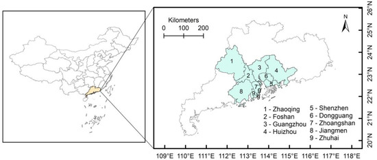
Figure 1.
The location of PRD and sample areas.
In early 2019, an official Outline Development Plan was issued, aiming at a more integrated level of development. Rural areas are an important part of the PRD, accounting for more than two-thirds of the whole area. The provincial government proposed to “promote the integration of towns and villages”, construct “characteristic towns”, and build a world-class urban agglomeration in the PRD. Town economy has developed greatly in Guangdong in recent years, which boosts rural revitalization and achieves common prosperity through transport infrastructure connectivity and equalization of public services. Among all towns, there are 142 characteristic towns in Guangdong province, including ecotourism types, fashion and creative types, emerging industry types, and historical and cultural types, covering many streets and towns. The top three by amount are Foshan (31), Guangzhou (21), and Meizhou (10). The PRD has rich samples of villages and towns with a high degree of integration and close regional ties. It is an opportunity to study the inter-town flows.
The dependent variable was indicated by the total frequency of population flow between towns. The flow data were extracted from a large set of mobile phone signaling data provided by China Telecom, one of three mobile communication operations in China. Its customers account for 20% of the population, and the representative dataset included information on the estimated locations of each cellphone user during April 2018. There are more than 12 million commuters distributed in 612 rural towns from 60 sub-cities of the Pearl River Delta (PRD) area. Since the original geographical resolution of data is 500 m, we aggregated the flow data by rural town divisions. This study used the external linkages from or to other rural towns to measure the strength and change in population flows. There are a total of 1,518,068 flows from 17,205 pairs of connected towns, and we omitted 11,185 pairs, which are 0, to obtain 6020, including 3157 for commuting and 2863 for non-commuting (Figure 2).
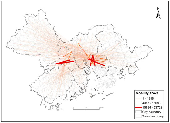
Figure 2.
Population flows occurring between rural towns to be analyzed.
2.2. Independent Variables and Data
According to the research objectives, independent variables at a town level were related to the built environment and socioeconomics from domains of population characteristics, economic development, traffic conditions, flow-level social data, and accessibility variables. Specifically, the population characteristics included age (proportion of population aged 15–64), gender (proportion of male population), population density (residential population/regional area). The data were obtained through preliminary calculation through the direct data of the sixth national census [33]. Economic development data included average house price and land use structure (the proportion of agricultural land in the total land area). To establish house price patterns, a process of crawling the point price within the town was conducted on the website: https://lianjia.com/city/ (accessed on 20 October 2019), and then, we calculated the average housing price by weighted average. The land use data came from the statistical yearbook of land and resources of Guangdong Province in 2015.
At the flow level, the dialect difference was referred to in the chronicles of Guangdong Province. According to the dummy variable assignment, the same dialects between the two places were set as 1, and the different dialects were set as 0; the boundary was divided into the district boundary and urban boundary. According to the assignment rules, the same district (city) was set to 1; otherwise, it was set to 0, and the data came from Baidu map. HSR and ICR indicate the frequency of connecting the two towns and were obtained from the railway information website: https://www.12306.cn (accessed on 20 October 2019). Car driving accessibility was indicated by the time of driving from the starting point to the destination obtained from Baidu map. The data statistics of each variable are shown in Table 1.

Table 1.
Variables and data descriptive statistics.
2.3. Methods
Distance has a significant impact, following the first law of geography that “near things are more related than distant things” [34,35]. Previously, the common method used to study the factors influencing travel behavior was a linear regression model, such as ordinary least squares (OLS) regression, logistic regression, probit regression model, discrete selection model, structural equation model, etc. These methods have validated the correlation between many factors and travel behavior, while the spatio-temporal variation in the relationship has not been precisely identified.
Considering mobility spatial non-stationarity in spatial interaction models, geographically weighted regression (GWR) has become one of the most popular methods. GWR methods allow for conditionalities between the response (causal) variables and changes in explanatory variables at different spatial scales. The flow-based geographically weighted regression (FGWR) method takes into account the interaction between flows; it was improved based on ordinary GWR, and the difference is that the spatial weight matrix is constructed by calculating the distance of the flows to estimate the parameters.
Firstly, when taking flow as the normal point, ordinary GWR modeling can be expressed as:
In Equation (1), where is a dependent variable indicating the p-th flow, represents the k-th independent variables on flow p, and n is the number of independent variables; here, n = 1, 2, 3, ……, 12. is the constant term related to the spatial position of flow p, whose coordinate is . is the coefficient of the k-th independent variable on flow p, and is the random disturbance. In Equation (2), the OD of flow p is i and j, respectively. It should be mentioned that location-based indicators of the origin and destination simultaneously have an influence on rural mobility flow. So, we use the absolute value of the difference () between the variable of O () and D () to measure the independent variables (Equation (2)). We mark the variables in the operational model with the symbol “Δ” before the original variable (Table 2).

Table 2.
Results of ordinary regression model.
Secondly, when solving the coefficient, of spatial weight,, we need to determine the bandwidth calculation method. Considering the fact that the flow in the same city or along the same route greatly interacts, the flow exceeding a specified critical distance will almost not have any effect on the calculation of the target flow. Adaptive bandwidth aims to search for the optimal number of nearest flows, which are used to determine the distance, .
In Equation (3), where is the distance function to estimate flow p and q. is the bandwidth, which indicates the optimal threshold distance. The evaluation standard for the optimal bandwidth is calculated by the AIC criterion. The AIC criterion can avoid over-fitting the model, and the smaller the AIC value, the better the model result.
Thirdly, in contrast to the distance between points, the distance between two flows is determined by the coordinate of OD. Here, if the OD of flow p and q are i, j and i’, j’, respectively, their coordinates are p(xi, yi), q(xj, yj), then the Euclidean distance, , is measured as Blainey and Preston [36] proposed in Equation (4):
Using Equations (3) and (4), we can obtain the spatial weight matrix and use ArcGIS 10.2 to run the FGWR model.
3. Results
This study firstly used global regression to quantify the total effect of factors on commuting and non-commuting, then FGWR was applied to explore the spatial distribution of the impact, that is, the local effect. Table 2 shows the results of the ordinary regression model for rural mobility. From the model fitting effect, by comparing the results with the ordinary least squares (OLS) method, the fitness of the FGWR model shows that it not only has a better log-likelihood value but also reduces the AIC and BIC. The value of log-likelihood is much larger, and AIC and BIC are smaller. This suggests that the FGWR model has higher performance and higher explanatory power than the general regression model, and the results of GWR have credibility.
In the ordinary regression model, it can be seen from Table 2 that the independent variables of socioeconomic factors seem to be not so significant, and the corresponding estimated coefficients of flow-based variables are mostly found to be statistically significant [37]. For the flow-based level between rural towns, administrative division and regional accessibility have significant heterogeneous effects on rural mobility. In Model 1, the variables of dialect (p < 0.1), district boundary (p < 0.01), urban boundary (p < 0.1), and car accessibility (p < 0.01) are significant. In Model 2, housing price (p < 0.05), district boundary (p < 0.01), and HSR (p < 0.05) are significant. This is generally consistent with our previous hypothesis, which shows that administrative division and regional accessibility have a significant effect on rural mobility.Then, FGWR was used to explore local effects, and the results of FGWR were mapped. Here, we highlight some important variables. The results show that the effect of administration division on rural mobility is more significant in non-commuting than in commuting. As depicted in Figure 3, the significance of the administration division on rural mobility is most pronounced in the center regions of Guangzhou, Foshan, and Dongguan, as well as their connections with western areas in terms of commuting mobility. Conversely, the district boundary has a greater impact on the mobility between Dongguan and Zhaoqing in the case of non-commuting. With respect to the urban boundary, the effects of it on rural mobility in the Guangzhou–Foshan community exhibit a disparity between the northern and southern areas. Specifically, for commuting mobility, the more substantial connections are located in the southern areas, while the significant links are situated in the north for non-commuting mobility.
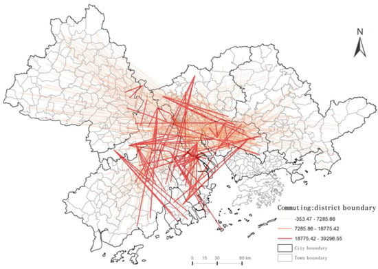
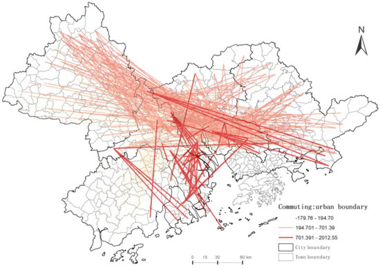
Figure 3.
The local effect of administration division on rural mobility for commuting.
Taking dialect as the test variable, we found that the coefficient is significantly positive, showing that communication between two towns is closer where the dialects are the same. Specifically, the commuting links of rural mobility exhibit greater significance within the region encircling the Pearl River., while the links across the east and west are more significant for non-commuting links (Figure 4).
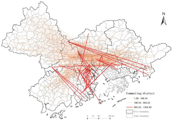
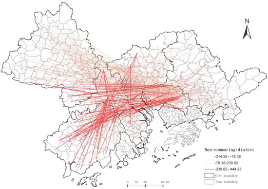
Figure 4.
The local effect of dialect on rural mobility.
For regional accessibility, car accessibility is negatively associated with mobility, that is to say, the less time used, the more links in the two towns. The key distinction lies in the fact that Foshan-Dongguan region displays greater connectivity with eastern regions in terms of daily commuting, while it exhibits a greater degree of connectivity with western regions for non-commuting purposes. (Figure 5). For commuting, cars play a more important role along the Pearl River, where the economy is relatively more developed and thereby more jobs is provided.
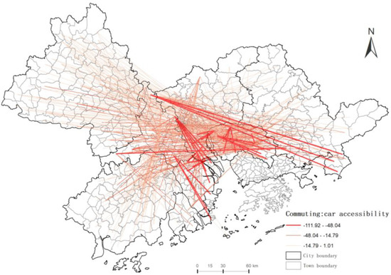
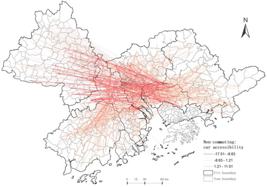
Figure 5.
The local effect of car accessibility on rural mobility.
Similarly, for commuting, HSR is significantly positive between core cities along the Pearl River, while it is more significant in connections between the northwest and center regions for non-commuting (Figure 6). In the vast rural areas, Foshan–Dongguan–Zhongshan are relatively developed towns, which are also employment centers with a cross-district commuting distance beyond urban public transport and private car. HSR is a regular way to fill this gap for business trips and working purposes. By comparison, the non-commuting links are dominant in the northwest, which owns rich ecological and natural tourism resources.
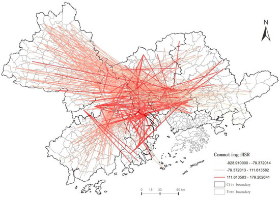
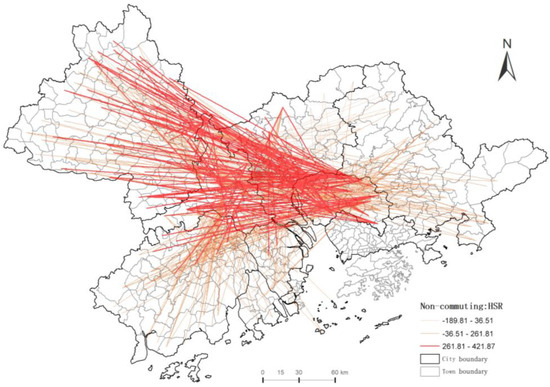
Figure 6.
The local effect of HSR on rural mobility.
4. Discussion
4.1. Local Effects of Administrative Division on Rural Mobility
Administrative division serves as a fundamental mechanism for regional control and governance in China. As a representation of spatial power [38], it plays a key role in shaping the economic and social management of rural areas. The impact of administrative division on human mobility, particularly rural mobility, is significantly affected by mechanisms such as the hukou system. The study of the border effects of administrative division on rural mobility is of great importance for urban planning and management.
In this work, the terms “district boundary” and “urban boundary” are utilized to denote the administrative division. These designations serve as useful indicators of the spatial delimitation of political power in the study area. The results of the flow-based geographically weighted regression (FGWR) analysis indicate that, as hypothesized, both district boundaries and city boundaries exert a positive influence on rural mobility. However, the effect of city boundaries on rural inter-town mobility is less pronounced, suggesting that the impact of administrative division on rural mobility is more pronounced within the same administrative region. Furthermore, this study finds that in remote rural areas, the lower level of administrative power, which is represented by district boundaries, has a more direct and tangible impact on the activities of farmers. These results are different from Zhang et al. [39] who argue that the constraint of administrative boundaries is dissolving. This phenomenon can be attributed to the interconnectedness between cities through the exchange of multiple resources. In contrast, rural towns are characterized by a pronounced disparity between different administrative levels, leading to a reliance on more advanced regions as a source of resources for the local population.
Dialect is a kind of culture, and if the dialects of two places are different, it may indicate a kind of regional difference and social barrier, which can be taken as an invisible boundary. It is interesting that dialects still play an important role in regional integrated development. This result confirms the important role of social culture in rural mobility and verifies the existing research [40].
4.2. The Local Effects of Regional Accessibility on Rural Mobility
Transportation interconnection plays an important role in regionalization, reducing developmental disparity, and achieving common prosperity [41]. It connects villages and towns in inter-town rural mobility and affects regional accessibility. The FGWR model gives a local and accurate degree of influence. Car accessibility is negatively associated with mobility, that is to say, the less time used, the more links in the two towns. Given the poor physical transportation, distance is a more important factor than municipality boundary, and the mobility between villages and towns that are relatively far away despite belonging to the same municipality can be hindered. As a result, the distance between villages and towns is generally greater than that of a bicycle, and a car is generally the most appropriate mode choice; therefore, the higher the accessibility by car, the stronger the connection between the two places. Table 2 supports our point of view.
There are more significant links which connect north and central areas for non-commuting. Our findings suggest that Guangzhou appears to play a more central role, which is consistent with Yeh et al. [42]. These results indicate that the employment density is high in areas of Guangzhou–Foshan–Dongguan, suggesting that the development of intercity transport infrastructure, such as intercity commuter rails, may play an important role in shaping the configuration of two existing regional cores (Guangzhou-led). However, the third core (near Zhuhai) does not seem to have met expectations of the outlined Development Plan, and more connected railways and other transport facilities can be built in the future.
4.3. Other Controlling Variables and Rural Mobility
China’s rural areas are undergoing a process of rapid urbanization, which is having a profound impact on the mobility of its inhabitants. Land use structure, especially the ratio of agriculture land area to industry land area, is negatively correlated with rural daily mobility, which indicates that more agricultural land has attracted more people to work locally; thus, inter-town mobility dropped off sharply. Specifically, land use structure may closely related to industry division as well as employment locations and, thus, influences the way residents commute. That is to say, the predominance of localized employment among primary industry practitioners, such as farmers, keeps the movements across regions. This finding supports Can Cui [5], who argues that industrial enterprises and tertiary industry employees have boosted directed population movements during weekdays and weekends for business trips and leisure activities. It is different from some existing research results from samples of inner cities where people can work locally [43], and this allows individuals to evade extensive commuting, such for long-distance commuting.
In terms of population characteristics, age is significantly related to rural mobility. It is suggested that the higher the percentage of the 15–64 years population and the higher the proportion of men, the stronger the mobility. It is a commonly accepted notion that the age cohort comprising young and middle-aged individuals constitutes the predominant driving force behind the phenomenon of mobility.. This is consistent with prior studies [22,23,25], which report that gender differences play a regulatory role in commuting decision-making, male employees (80.50%) are more willing to commute than female employees, and men commute longer than female partners. Additionally, no firm conclusions can be drawn yet on the effect of population density. Some studies argue that population density reduces car ownership and shows expected direct negative effects on travel distance [44] while promoting the use of public transport such as buses and subways [45]. The results of this analysis indicate a statistically significant negative correlation between housing price and mobility. This suggests that individuals residing in regions of higher housing price, tend to exhibit a higher frequency of inter-town travel. One possible explanation for this phenomenon is the greater physical distance between homes and amenities in areas with higher housing costs. Additionally, housing prices serve as an indicator of economic development and are, therefore, positively correlated with increased mobility, which is in accordance with prior research which has demonstrated a positive and stable relationship between economic factors and population movement patterns in China [46]. This finding is congruent with previous studies on daily intercity mobility within the Yangtze River Delta region, reinforcing the validity of the observed correlation between housing price and population mobility [5]. Moreover, the results reveal that road density has a statistically significant impact on rural mobility. Specifically, a higher road density is associated with lower levels of rural mobility. An examination of the road network evolution in Changchun, China, provides additional support for this conclusion [47], as it demonstrates that an increase in road density results in shorter average road segment lengths and reduces travel distances overall. These findings suggest that the development and expansion of road networks can play a crucial role in shaping population movement patterns in rural areas and should be carefully considered in efforts of urban and regional planning.
5. Conclusions
This study contributes to the existing research by investigating the impact of administrative division and regional accessibility on rural mobility in PRD and improving the traditional GWR model by considering the spatial correlation of flows to quantify the local effect. The FGWR method takes account of the interaction and spatial heterogeneity, which improves the accuracy of model fitness. Based on mobile phone signaling data, we investigated the rural mobility of 612 towns with targeted variables. By quantitatively examining these effects, it is possible to gain a deeper understanding of the influencing factors and mechanisms of rural mobility and of significance for effective policies to promote sustainable regional development.
5.1. Main Results
Our findings demonstrate a significant impact of administrative division and regional accessibility on rural mobility. This study reveals that administrative division, which serves as a proxy for differences in institutional arrangements and governance, plays a crucial role in shaping mobility patterns. Additionally, our results highlight the importance of regional accessibility in facilitating rural mobility, which can be influenced by transportation infrastructure, such as HSR. These findings provide important insights for policymakers seeking to develop effective interventions for promoting rural mobility and enhancing regional integration. Specifically:
(a) The effects of district boundaries on commuting mobility are more likely in center areas along the Pearl River, while the effects of city boundaries on non-commuting mobility between the core area and the surrounding region are more significant. These findings provide valuable insights into the mechanisms by which administrative division shapes mobility patterns in rural areas and contribute to the understanding of the interplay between governance and spatial dynamics. Institution convergence and policy coordination, such as mutual recognition of social security accounts and eliminating registered residence discrimination in employment, may promote mobility for rural development and country economic integration.
(b) For regional accessibility, car accessibility is negatively associated with rural mobility, and Foshan-Dongguan has more significant links with east areas for commuting, while there are more significant links with western areas for non-commuting. HSR is positive significantly on rural mobility between core cities along the Pearl River, while it is more significant in mobility between northwest and center regions for non-commuting. Thus, the network of road construction priority should be given to the connection between the core employment areas along the Pearl River for commuting. Taking advantage of long-distance travel, HSR should be laid along the trajectories of remote areas with center regions.
(c) Other socioeconomic demographics and built environments are mostly not significant and illustrate a mix-direction effect on rural mobility. Specifically, housing price plays a positive role in mobility. Land use structure is negative but not significant. Road density is positive with the commuting flow while negative with the non-commuting flow. These results provide insights into rural mobility and should be carefully considered in regional development.
5.2. Limitations and Recommendations
This study has made an important contribution to the understanding of factors related to rural mobility, including a comparison between commuting and non-commuting. However, there still remain opportunities for future work. Firstly, the mobile signaling data used in this study only covers a one-week period and is restricted to the Pearl River Delta region; future studies could benefit from a more abundant data to provide additional evidence. Secondly, the computational model used in this study omits certain variables, and future studies could try more advanced models to address these limitations. Thirdly, future studies could consider additional types of mobility flows, such as urban–rural mobility, to provide a more comprehensive understanding of the phenomena.
Author Contributions
Conceptualization and writing—original draft, Y.Z.; resources and data curation, D.L.; visualization, P.Z.; Data curation, formal analysis, S.X.; supervision and writing—review and editing, W.Z. All authors have read and agreed to the published version of the manuscript.
Funding
This research was funded by the National Key R&D Program of China (Grant No.2018YFD1100304-2) and Guangdong Basic and Applied Basic Research Foundation (Grant No.2023A1515010994).
Data Availability Statement
Not applicable.
Conflicts of Interest
The authors declare no conflict of interest.
References
- Harral, C.; Faiz, A. Road Deterioration in Developing Countries: Causes and Remedies; The World Bank: Washington, WA, USA, 1988. [Google Scholar]
- Raza, A.; Safdar, M.; Zhong, M.; Hunt, J.D. Analyzing Spatial Location Preference of Urban Activities with Mode-Dependent Accessibility Using Integrated Land Use–Transport Models. Land 2022, 11, 1139. [Google Scholar] [CrossRef]
- Hák, T.; Janoušková, S.; Moldan, B. Sustainable Development Goals: A need for relevant indicators. Ecol. Indic. 2016, 60, 565–573. [Google Scholar] [CrossRef]
- Zhao, P.; Yu, Z. Investigating mobility in rural areas of China: Features, equity, and factors. Transp. Policy 2020, 94, 66–77. [Google Scholar] [CrossRef]
- Cui, C.; Wu, X.; Liu, L.; Zhang, W. The spatial-temporal dynamics of daily intercity mobility in the Yangtze River Delta: An analysis using big data. Habitat Int. 2020, 106, 102174. [Google Scholar] [CrossRef]
- Raza, A.; Akuh, R.; Safdar, M.; Zhong, M. Public Transport Equity with the Concept of Time-Dependent Accessibility Using Geostatistics Methods, Lorenz Curves, and Gini Coefficients. Case Stud. Transp. Policy 2023, 11, 100956. [Google Scholar] [CrossRef]
- Kamruzzaman, M.; Hine, J. Analysis of rural activity spaces and transport disadvantage using a multi-method approach. Transp. Policy 2012, 19, 105–120. [Google Scholar] [CrossRef]
- Nutley, S.D. Rural transport problems and non-car populations in the USA: A UK perspective. J. Transp. Geogr. 1996, 4, 93–106. [Google Scholar] [CrossRef]
- Beyazit, E. Evaluating Social Justice in Transport: Lessons to be Learned from the Capability Approach. Transp. Rev. 2011, 31, 117–134. [Google Scholar] [CrossRef]
- Lucas, K. Transport and social exclusion: Where are we now? Transp. Policy 2012, 20, 105–113. [Google Scholar] [CrossRef]
- Millward, H.; Spinney, J. Time use, travel behavior, and the rural–urban continuum: Results from the Halifax STAR project. J. Transp. Geogr. 2011, 19, 51–58. [Google Scholar] [CrossRef]
- Sultana, S.; Guimbretière, F.; Sengers, P.; Dell, N. Design Within a Patriarchal Society: Opportunities and Challenges in Designing for Rural Women in Bangladesh. In Proceedings of the 2018 CHI Conference on Human Factors in Computing Systems, Montreal, QC, Canada, 21–26 April 2018; p. 536.
- Zhang, W.; Derudder, B.; Wang, J.; Shen, W. Regionalization in the Yangtze River Delta, China, from the perspective of inter-city daily mobility. Reg. Stud. 2018, 52, 528–541. [Google Scholar] [CrossRef]
- Wang, L.; Wu, X.; He, Y. Nanjing’s Intracity Tourism Flow Network Using Cellular Signaling Data: A Comparative Analysis of Residents and Non-Local Tourists. ISPRS Int. J. Geo-Inf. 2021, 10, 674. [Google Scholar] [CrossRef]
- Derudder, B.; Taylor, P. Change in the World City Network, 2000–2012. Prof. Geogr. 2016, 68, 624–637. [Google Scholar] [CrossRef]
- Zhang, W.; Thill, J.-C. Mesoscale structures in world city networks. Ann. Am. Assoc. Geogr. 2019, 109, 887–908. [Google Scholar] [CrossRef]
- Burger, M.; Meijers, E. Form Follows Function? Linking Morphological and Functional Polycentricity. Urban Stud. 2011, 49, 1127–1149. [Google Scholar] [CrossRef]
- Niu, C.; Zhang, W. Causal effects of mobility intervention policies on intracity flows during the COVID-19 pandemic: The moderating role of zonal locations in the transportation networks. Comput. Environ. Urban Syst. 2023, 102, 101957. [Google Scholar] [CrossRef] [PubMed]
- Zhang, W.; Gong, Z.; Niu, C.; Zhao, P.; Ma, Q.; Zhao, P. Structural changes in intercity mobility networks of China during the COVID-19 outbreak: A weighted stochastic block modeling analysis. Comput. Environ. Urban Syst. 2022, 96, 101846. [Google Scholar] [CrossRef] [PubMed]
- Zhao, M.; Derudder, B.; Huang, J. Examining the transition processes in the Pearl River Delta polycentric mega-city region through the lens of corporate networks. Cities 2017, 60, 147–155. [Google Scholar] [CrossRef]
- Bowman, J.L.; Ben-Akiva, M.E. Activity-based disaggregate travel demand model system with activity schedules. Transp. Res. Part A Policy Pract. 2001, 35, 1–28. [Google Scholar] [CrossRef]
- Zhang, W.; Lu, D.; Chen, Y.; Liu, C. Land use densification revisited: Nonlinear mediation relationships with car ownership and use. Transp. Res. Part D Transp. Environ. 2021, 98, 102985. [Google Scholar] [CrossRef]
- Zhang, W.; Lu, D.; Zhao, Y.; Luo, X.; Yin, J. Incorporating polycentric development and neighborhood life-circle planning for reducing driving in Beijing: Nonlinear and threshold analysis. Cities 2022, 121, 103488. [Google Scholar] [CrossRef]
- Zhang, W.; Zhang, M. Incorporating land use and pricing policies for reducing car dependence: Analytical framework and empirical evidence. Urban Stud. 2018, 55, 3012–3033. [Google Scholar] [CrossRef]
- Zhang, W.; Zhao, Y.; Cao, X.J.; Lu, D.; Chai, Y. Nonlinear effect of accessibility on car ownership in Beijing: Pedestrian-scale neighborhood planning. Transp. Res. Part D Transp. Environ. 2020, 86, 102445. [Google Scholar] [CrossRef]
- Kornbeck, J. Linguistic affinity and achieved geographic mobility: Evidence from the recognition of non-national social work qualifications in Ireland and the UK. Eur. J. Soc. Work 2004, 7, 143–165. [Google Scholar] [CrossRef]
- Porter, A.; Kontou, E.; McDonald, N.; Evenson, K. Perceived barriers to commuter and exercise bicycling in U.S. adults: The 2017 National Household Travel Survey. J. Transp. Health 2020, 16, 100820. [Google Scholar] [CrossRef]
- Ding, C.; Liu, C.; Zhang, Y.; Yang, J.; Wang, Y. Investigating the impacts of built environment on vehicle miles traveled and energy consumption: Differences between commuting and non-commuting trips. Cities 2017, 68, 25–36. [Google Scholar] [CrossRef]
- Jia, Y.; Fu, H. Association between innovative dockless bicycle sharing programs and adopting cycling in commuting and non-commuting trips. Transp. Res. Part A Policy Pract. 2019, 121, 12–21. [Google Scholar] [CrossRef]
- Mohiuddin, H.; Jamal, S.; Rahman Bhuiya, M.M. To bike or not to bike: Exploring cycling for commuting and non-commuting in Bangladesh. Transp. Res. Interdiscip. Perspect. 2022, 14, 100614. [Google Scholar] [CrossRef]
- Sottile, E.; Tuveri, G.; Piras, F.; Meloni, I. Modelling commuting tours versus non-commuting tours for university students. A panel data analysis from different contexts. Transp. Policy 2022, 118, 56–67. [Google Scholar]
- Masoumi, H. Home-Based urban commute and Non-Commute trip generation in Less-Studied Contexts: Evidence from Cairo, Istanbul, and Tehran. Case Stud. Transp. Policy 2022, 10, 130–144. [Google Scholar] [CrossRef]
- Statistics, N.B.O. China County Statistical Yearbook; China Statistical Press: Beijing, China, 2019. [Google Scholar]
- Tobler, W.R. A computer movie simulating urban growth in the Detroit region. Econ. Geogr. 1970, 46, 234–240. [Google Scholar] [CrossRef]
- Raza, A.; Zhong, M.; Safdar, M. Evaluating Locational Preference of Urban Activities with the Time-Dependent Accessibility Using Integrated Spatial Economic Models. Int. J. Environ. Res. Public Health 2022, 19, 8317. [Google Scholar] [CrossRef]
- Blainey, S.; Preston, J. Extending geographically weighted regression from points to flows: A rail-based case study. Proc. Inst. Mech. Eng. Part F J. Rail Rapid Transit 2013, 227, 724–734. [Google Scholar] [CrossRef]
- Safdar, M.; Jamal, A.; Al-Ahmadi, H.M.; Rahman, M.T.; Almoshaogeh, M. Analysis of the Influential Factors towards Adoption of Car-Sharing: A Case Study of a Megacity in a Developing Country. Sustainability 2022, 14, 2778. [Google Scholar] [CrossRef]
- Feng, R.; Wang, K. The direct and lag effects of administrative division adjustment on urban expansion patterns in Chinese mega-urban agglomerations. Land Use Policy 2022, 112, 105805. [Google Scholar] [CrossRef]
- Zhang, W.; Fang, C.; Zhou, L.; Zhu, J. Measuring megaregional structure in the Pearl River Delta by mobile phone signaling data: A complex network approach. Cities 2020, 104, 102809. [Google Scholar] [CrossRef]
- Liu, K.; Murayama, Y.; Ichinose, T. A multi-view of the daily urban rhythms of human mobility in the Tokyo metropolitan area. J. Transp. Geogr. 2021, 91, 102985. [Google Scholar] [CrossRef]
- Zhang, X.; Shen, J.; Gao, X. Towards a comprehensive understanding of intercity cooperation in China’s city-regionalization: A comparative study of Shenzhen-Hong Kong and Guangzhou-Foshan city groups. Land Use Policy 2021, 103, 105339. [Google Scholar] [CrossRef]
- Yeh, A.G.O.; Yang, F.F.; Wang, J. Producer service linkages and city connectivity in the mega-city region of China: A case study of the Pearl River Delta. Urban Stud. 2014, 52, 2458–2482. [Google Scholar] [CrossRef]
- Zhang, M.; Zhang, W. When context meets self-selection: The built environment–travel connection revisited. J. Plan. Educ. Res. 2020, 40, 304–319. [Google Scholar] [CrossRef]
- Ding, C.; Wang, D.; Liu, C.; Zhang, Y.; Yang, J. Exploring the influence of built environment on travel mode choice considering the mediating effects of car ownership and travel distance. Transp. Res. Part A Policy Pract. 2017, 100, 65–80. [Google Scholar] [CrossRef]
- Shen, Q.; Chen, P.; Pan, H. Factors affecting car ownership and mode choice in rail transit-supported suburbs of a large Chinese city. Transp. Res. Part A Policy Pract. 2016, 94, 31–44. [Google Scholar] [CrossRef]
- Zhang, F.; Ning, Y.; Lou, X. The evolutionary mechanism of China’s urban network from 1997 to 2015: An analysis of air passenger flows. Cities 2021, 109, 103005. [Google Scholar] [CrossRef]
- Wang, S.; Yu, D.; Kwan, M.-P.; Zheng, L.; Miao, H.; Li, Y. The impacts of road network density on motor vehicle travel: An empirical study of Chinese cities based on network theory. Transp. Res. Part A Policy Pract. 2020, 132, 144–156. [Google Scholar] [CrossRef]
Disclaimer/Publisher’s Note: The statements, opinions and data contained in all publications are solely those of the individual author(s) and contributor(s) and not of MDPI and/or the editor(s). MDPI and/or the editor(s) disclaim responsibility for any injury to people or property resulting from any ideas, methods, instructions or products referred to in the content. |
© 2023 by the authors. Licensee MDPI, Basel, Switzerland. This article is an open access article distributed under the terms and conditions of the Creative Commons Attribution (CC BY) license (https://creativecommons.org/licenses/by/4.0/).