Abstract
Historical maps, especially those at a small scale and rich in detail (e.g., the old “Cadastres”), represent an exceptionally important tool for understanding the recent historical evolution of landscapes. The note describes the example of the territory of Gubbio, in Umbria (Central Italy), where a map from the end of the 16th century shows a drawing of the hydrographic network partially different from the current one. A multidisciplinary study based on field surveys, observations of satellite images, archaeological discoveries, and archival research proved useful to confirm what was reported by the cartographer at the time. The possible causes that led to this variation of the surface hydrography up to its current configuration are then discussed in the light of other documentary finds from the archives, taken from the chronicles of the time, which have made it possible to identify, with sufficient approximation, the period where this change occurred. All this leads to a highlighting of a profound evolution of fluvial and slope morphogenetic processes that have affected the study area in recent centuries, in which the regulation of surface waters and afforestation, conducted during the 20th century, have played a decisive role.
1. Introduction
The study of landscape evolution, especially in the case of areas characterized by anthropic presence since ancient times, requires a multidisciplinary approach due to the great variety of sources to be used (historical maps, archival documents, field investigation data both geological-geomorphological and archaeological, the latter being connected with anthropological aspects). The morphogenetic processes often underwent changes in historical times, almost always induced by human activity, i.e., the upsets of the hydrographic network due to the building of dams and the hydraulic works in the riverbeds and hydrographic basins, conducted mainly during the 19th and 20th centuries [1,2,3,4]; the land use change from forest to agriculture, or from agriculture to urbanization [5,6,7]. These interventions have frequently led to a mitigation of the hydrogeological risk but, at times, also to its increase [8,9,10,11,12].
Historical cartographic documents have been an important source of data for identifying the changes, natural and/or induced, which have characterized the evolution of the landscape over the last few centuries [13,14,15,16,17,18,19]. Among these, large-scale and handwritten administrative maps are particularly useful, as they constitute the most reliable and rich in content original sources compared to printed maps [20]. In Italy, for example, between the end of the 18th and the beginning of the 19th century, various “Cadastres” were produced which, although they only report information of a planimetric type, provide excellent information, especially about the configuration of streams, before the important hydraulic works that significantly modified the planimetric track of the streams themselves. The Napoleonic Cadastre was published in 1812 for northern Italy. The Gregorian Cadastre (1816–1835) and the Lorraine Cadastre (1776–1832) were published for central Italy; the Bourbon Cadastre, also created in the first half of the 19th century were published for southern Italy. Furthermore, modern territorial analysis techniques that use geographic information systems (GIS) allow comparisons between historical maps and the current conformation of natural and man-made environments with a high degree of accuracy [21,22,23,24].
This study describes an emblematic case that highlights the importance of historical cartographic analysis in understanding the recent evolution of the landscape. One of the main and oldest historical maps of the territory of Gubbio (Umbria, Central Italy) was examined; according to scholars, this is the first example of the use of mapping for demographic survey purposes [25]. From the map, dated to the 16th century, albeit stylized, a hydrographic network emerges within the plain of Gubbio, which is partially different from the current one. This induced research includes the use of a field survey of geomorphological clues and historical finds. It also prompted the analysis of documents and other subsequent cartographic sources of causes that may have produced the transformation of the hydrographic network itself up to its current configuration. The identification of these causes implies that the recognition of morphogenetic processes is significantly different from those in progress today, with the consequent modifications of the hydrogeological risk conditions.
2. Materials and Methods
The Gubbio basin (Umbria, Central Italy) is examined, of which the geological-geomorphological peculiarities are described below, as well as the “Georgi’s Map” (1570), one of the most important historical cartographic documents, which is specifically the object of the note.
2.1. Geological-Geomorphological Framework of the Study Area
To understand the evolution of the landscape in the study area, it is essential to refer to its geological-structural characteristics, which have strongly controlled the “footprint” of the landscape itself, as normally occurs in areas affected by recent tectonics. Indeed, the Gubbio Plain represents one of the classic intermontane basins located on the western side of the Apennine Chain in Central Italy (Figure 1) [26].
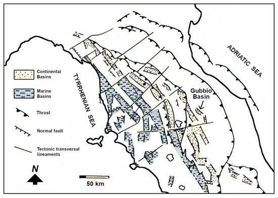
Figure 1.
The marine and continental basins (graben and semi-graben) that characterize the Tyrrhenian side of the Apennine Chain in central Italy. The Gubbio basin is the easternmost; therefore, it is the most recent together with the Gualdo Tadino basin (immediately to the side). From [14], modified.
This is a fold mountain belt, verging towards the Adriatic Sea, which was formed due to compressive tectonic induced by the counterclockwise rotation of the Italian peninsula. The compressive tectonic phase, still underway on the eastern (Adriatic) side of the chain, was superimposed in a spatial-temporal sense by an extensional phase of crustal thinning which produced the formation of tectonic trenches, i.e., graben and semi-graben [27,28,29,30]. The Apennine intermontane basins—of which that of Gubbio is the most recent and easternmost, together with Gualdo Tadino—represent the geomorphological expression of this extensional tectonic phase which begun in the Pliocene and still affects the western slope of the Apennine Chain. It is thus responsible for the seismicity present in this area [31,32,33].
The two tectonic phases have left evident traces in the territory of Gubbio. The compressive phase produced the formation of a brachyanticline (Figure 2) [34], where the marine environment formations, mainly calcareous and calcareous-marly (dating from the Jurassic to the Miocene) of the Umbria-Marche stratigraphic series, outcrop and today constitute the structure of the relief that overlooks the city.
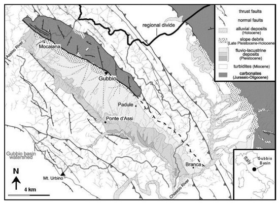
Figure 2.
Geological map of Gubbio basin (from [34], modified).
The extensional phase was superimposed from the previous one, cutting the aforesaid anticline precisely in correspondence with its nucleus via an important normal fault [35]. It produced a large tectonic trench, i.e., the Gubbio Plain, which spans about 24 km in a NW-SE direction. The subsidence of this basin, with endorheic characteristics, initially allowed the formation of a lake, in the Plio-Pleistocene age, subsequently drained and filled by sediments in lacustrine and fluvial-lacustrine facies transported by streams flowing from both sides (north-eastern and south-western) of the basin itself [36,37]. The establishment of the graben generated a local base level of erosion for all these rivers which, from the area in subsidence, began their process of regressive erosion [38]. The result, from the geomorphological point of view, is the alignment of a series of reliefs (Gubbio Mountains), structurally constituted by what remains of the anticline fold and divided from each other by narrow valleys, produced from the streams that flow into the Gubbio Plain forming large alluvial fans (Figure 3) [39].
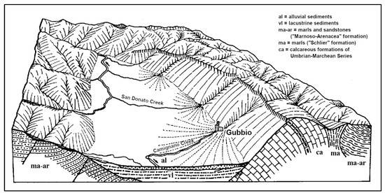
Figure 3.
Block diagram of Gubbio basin (from [39], modified).
There are concerns regarding the hydrographic network in the Gubbio Plain. It is bordered to the NW and SW, and at its ends, by two rivers: the Assino River, which drains at the northern portion of the plain, and the Chiascio River, which drains at its central-southern portion. The divide between the two basins is located properly inside the Gubbio Plain, in correspondence with the large, low-sloping alluvial fan formed by the San Donato Creek at its outlet in the plain area. This aspect is important and will be discussed later.
2.2. The Georgi’s Map
The “Georgi’s Map”—also titled “Diocese della città di Ugubbio, descritta dal R.mo don Ubaldo Georgii clerico Eugubino. Ad istanza di monsignore Ill.mo Et Re.mo Mariano Savello vescovo dignissimo” (Figure 4)—was made in the second half of the 16th century and represents one of the most important historical cartographic documents of the Gubbio area. One specimen is kept in the Municipal Museum of Gubbio (inv. No. 2414 (6505)). It consists of two copper plates, each measuring 475 × 680 mm, and owes its origin to the decisions taken within the Council of Trent (1563) during which a document was approved asking parish priests to draw up a status animarum of their own parish through a real demographic census [25,40,41,42,43].
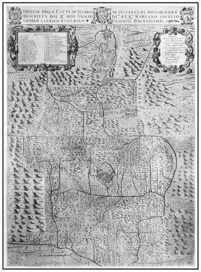
Figure 4.
The Georgi’s Map—Municipal Museum of Gubbio, inv. No. 2414 (6505).
In 1567, the bishop of Gubbio (mons. Mariano Savelli) ordered all parish priests of the Diocese to indicate the number of families belonging to their own parish and the distances that separated them from their respective churches. In 1570, the bishop commissioned the cleric don Ubaldo Georgi, who was considered to be an excellent geographer [44], to graphically transpose all the information received. From the data found by Allegrucci [25], it can be deduced that in 1571 Georgi went to Venice with the design of the map and stayed there for a year to have the map engraved; the “coppers” were then brought to Gubbio.
The document, a real topographic map, depicts a relatively large territory, at a scale of extreme detail for the period in which it was drawn up (normally, the maps of this period are at a significantly smaller scale), and it is also a thematic map, considering that it represents the population of the Diocese. In fact, the territory is divided into squares and rectangles, each of which delimits, albeit approximately, the various parish districts. The particularity of the map consists in the fact that it represents a unicum, as in no other Diocese the surveys promoted by the Council of Trent were graphically converted into a map. Furthermore, it represents the first cartography created specifically in the Gubbio area.
2.3. The Anomaly of the Hydrographic Network Represented in the Georgi’s Map
By carefully examining Georgi’s Map, a substantial difference in the hydrographic network represented by the cartographer compared to the current situation can be observed. The map, in its lower portion, represents the plain of Gubbio, bordered on the right (SE) by the Chiascio River and on the left (NW) by the Assino River. The divide between the two hydrographic catchments, which drain towards the Assino and Chiascio Rivers, respectively, is moved much more to the left (NW) than the current one, so much so that, to the NW of the town of Gubbio, the San Donato Creek, although represented in a stylized way, unequivocally flows into the Saonda River, a tributary of the Chiascio River. Currently, it is an integral part of the hydrographic network which belongs to the Assino River. The same applies to a minor tributary, the creek located between Nerbisci and S. Martino in Colle, on the opposite side of the Gubbio basin: it too, today flowing into the San Donato stream, is represented in Georgi’s Map as a tributary of the Saonda River (Figure 5).
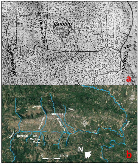
Figure 5.
Comparison between (a) Georgi’s Map and (b) the present situation (from Google Earth—https://earth.google.com/, highlighting the main hydrographic network).
An error by the cartographer can reasonably be excluded, considering the extreme detail with which the natural and anthropic elements are represented and above all the proximity of the place to the city of Gubbio (therefore in an area that is not impervious and easily accessible). The problem then arises of the search for clues, from land and documents, which testify to the presence of a fluvial track of the San Donato Creek different from the current one, as well as the causes and the period in which the diversion, which led to the present situation, may have occurred.
2.4. The Data Available
The study was carried out following two lines of research: (1) The field investigation, which attempted to search for geomorphological clues and archaeological finds that could highlight the presence of a fluvial track of the San Donato Creek different from the current one; (2) the search for archival material (cartographic and possibly documentary) on the subject.
2.4.1. The Field Investigation
The direct investigation in the field proved difficult, considering that the area in question has always been developed and is used mainly for agriculture. Therefore, there are no outcrops of autochthonous and unaltered material along the presumed ancient fluvial track of the San Donato Creek, which can be attributed to infill of sediments of fluvial origin.
On the other hand, the analysis of aerial photos proved to be more important and useful, from which it is possible to identify, through a wider aerial view, any indications of a paleo-riverbed. In fact, the identification of ancient river tracks, especially in lowland areas, is facilitated by the fact that the sub-surface channel deposits are clearly evident, above all following precipitation events, for the different colors they assume due to their degree of humidity and their permeability, different from the neighboring areas. Therefore, the search for aerial photos via Google Earth was very useful, exploiting its potential and above all the fact that the photos present refer to different periods (which can be inspected via the menu item “show historical images”). Among the photos available in this area, there is one in particular whose acquisition date is 29 May 2017. It shows with extraordinary evidence the indications of a drainage line placed along the San Donato Creek at its outlet in the plain of Gubbio, which most likely follows the ancient fluvial track of this stream, as reported in Georgi’s Map (Figure 6), i.e., directed towards the Saonda River.
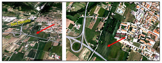
Figure 6.
Evidence (red arrows) of San Donato Creek’s paleo-riverbed (from Google Earth—https://earth.google.com/).
Furthermore, there is another important element in favor of this interpretation. During the works carried out in 2014 for the construction of the new church of the Madonna del Ponte (church of the Mother of the Savior), today located precisely according to the direction of the presumed paleo-riverbed of the San Donato Creek, very interesting archaeological and geological data emerged. The preparatory excavation works for the construction of the new church have brought to light an ancient artifact consisting of a small chapel which had probably incorporated a pre-existing rural aedicule dating back to the 15th century (Figure 7). This is located close to the place where the old church of the Madonna del Ponte was built during the 16th century.
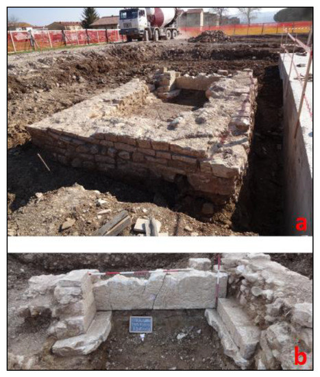
Figure 7.
The ruins of the artifact, probably a small chapel (a) with an aedicule inside, detailed in (b).
In particular, the excavations of 2014 highlighted the presence of a sedimentary body, which transversely cut the entire construction site at a depth of 0.5–1 m from ground level. This lithosome was clearly distinguishable from the neighboring alluvial sediments and consisted of well-processed pebbles with a good degree of rounding, with an average size of 6–8 cm (also used for the construction of the perimeter walls of the aedicule) in an abundant silty-sandy matrix (Figure 8).
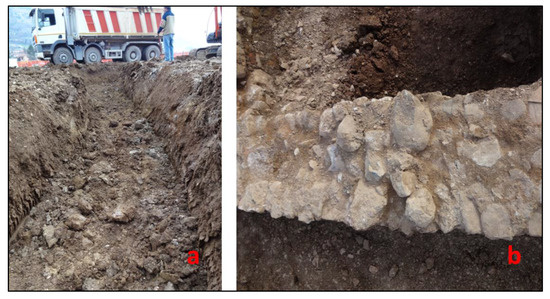
Figure 8.
(a) The trench made during the excavation of the building in Figure 7; (b) pebbles of clear fluvial origin used to build the artifact.
The position of this sedimentary body, located right along the line of the hypothetical paleo-riverbed of the San Donato Creek, as represented by Georgi, and its lithological-sedimentary characteristics make the presence of a river channel probable in this area.
Currently, on the main altar of the church of the Madonna del Ponte, near the bridge over the San Donato Creek, there is a detached block fresco coming from the chapel described above. It is assumed that the aedicule, contained in it, was placed near the bank of the San Donato Creek to invoke protection from any damage that the stream could cause with its floods, as was the custom in that period and in the following centuries [45]. See, for example, the still present aedicule, located on the right bank of the Camignano River, near the bridge that crosses it in the San Martino district, within the historic center of Gubbio (Figure 9). The fresco in question (Figure 10) depicts the Madonna and Child enthroned between St. Bernardino and a holy bishop (perhaps St. Ubaldo or St. Donato) and is attributed to the Gubbio painter Jacopo Bedi who realized it shortly after the mid-15th century.
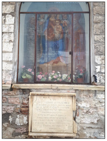
Figure 9.
Aedicule located on the right bank of the Camignano Creek, close to the bridge that crosses it in the San Martino quarter, in the historic center of Gubbio.
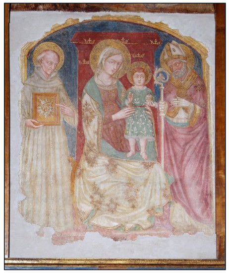
Figure 10.
Fresco detached in block currently located in the Church of Madonna del Ponte.
Some archival documents relating to Jacopo Bedi, dated between 1460 and 1478 [46], ensure that the painter owned land in the Villa of Spognola, located on the right bank of the San Donato Creek, near the bridge already called at that time “of San Donato”.
It cannot be excluded, though it is possible, that the majesty or the small chapel where the fresco was originally placed, was located precisely in one of the lands owned by the 15th-century painter from Gubbio near the San Donato bridge. Even the dimensions of the small building found in the area now occupied by the new church of the Mother of the Savior, especially those of its back wall, are compatible with those of the detached fresco (150 × 150 cm).
2.4.2. The Historical-Cartographic Investigation
Next, we analyzed historical maps subsequent to Georgi. We referred to the same area of study to search for the one closest in time to Georgi’s Map, in which the San Donato Creek was depicted in the position in which it is currently located. This was done to identify the time interval in which the diversion phenomenon of the San Donato Creek may have occurred. The maps examined are listed in Table 1, in increasing order of age.

Table 1.
The historical maps examined.
We found the examined cartography, which was produced before Georgi’s Map (1570), to be unhelpful, as it is not detailed enough to confirm that how the San Donato Creek flowed into the Saonda River (Chiascio River basin). These maps are drawn on too small a scale, which does not allow for a degree of detail that can correctly identify the hydrograph network of the Gubbio Plain (Figure 11).
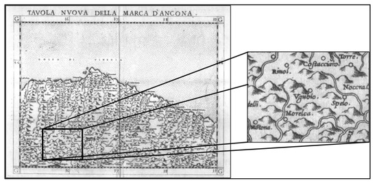
Figure 11.
“Tavola Nuova della Marca d’Ancona” (Ruscelli, 1561). In the box: the enlargement of the Gubbio area.
Some maps produced after Georgi’s present the same problem because the Gubbio area is located on the edges of the cartographic representation and is therefore not well sketched (Figure 12). Others, which are in any case the majority, all show the San Donato Creek with a track like the current one, i.e., flowing into the Assino River (Figure 13). Among the latter, the closest in time to Georgi’s Map is “Urbini Ducatus” by Egnatio Danti, produced between 1580 and 1582 and preserved as a mural painting in Rome, in the Vatican Museums (Figure 14 and Figure 15).
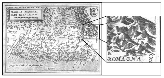
Figure 12.
“Marcha Anconae, olim Picenum” (Ortelio, 1572). In the box: the enlargement of the Gubbio area.
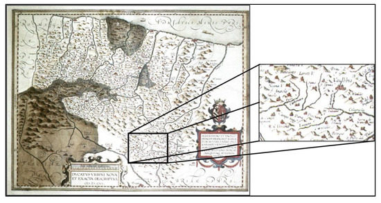
Figure 13.
“Ducatus Urbini nova et exacta descriptio” (Ortelio, 1606). In the box: the enlargement of the Gubbio area.
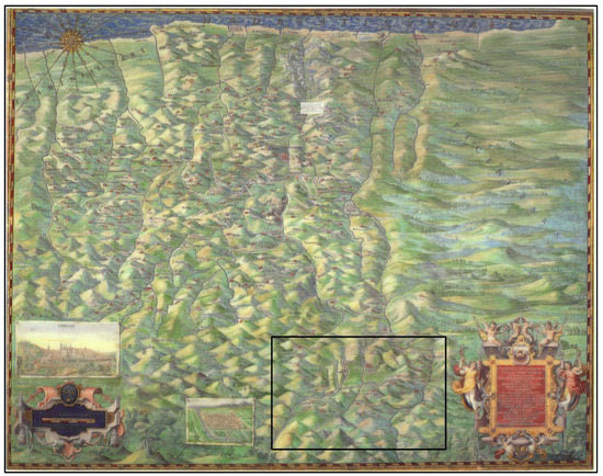
Figure 14.
“Urbini Ducatus” (Egnatio Danti, 1580–1582). In the square: the Gubbio area (highlighted in Figure 15.
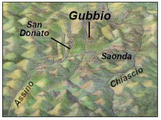
Figure 15.
A detail of “Urbini Ducatus” by Egnatio Danti (1580–1582)—see Figure 14.
3. Results
From the available field and historical-cartographic data, two important elements emerge. The first is that there are numerous clues of a geological and geomorphological nature linked to the discovery of architectural and pictorial finds, which seem to confirm what Georgi represented regarding a track of the San Donato Creek different from the current one. The second concerns the period in which this diversion of the track may have occurred. It can reasonably be assumed that this occurred between 1571 (the year Georgi went to Venice to have the “coppers” of his paper engraved, as reported by Allegrucci [25]) and 1582 (the year Danti finished his painting).
Some questions remain unresolved, such as what the causes are that could produce the modification of the river track—i.e., natural or anthropogenic causes?
The Causes of the Modification of the Fluvial Track of the San Donato Creek
The possibility of an error by Georgi in drawing the fluvial track of the San Donato Creek on his map can be excluded. This hypothesis, in fact, appears unlikely, both taking note of the recognized competence and professionalism of Georgi himself, and because the area was easily accessible even for those times, and just as directly “verifiable.” Furthermore, the purpose of the map must be considered: the abundance of details with which it was drawn up does not make credible that it could be an error, which would have been too obvious to remain unnoticed.
Two possible hypotheses remain:
- a “forced” deviation, artificially induced by hydraulic works in the riverbed, which would therefore have constrained it to modify its track;
- a natural cause, whereby the stream would have changed direction “spontaneously” caused by a flood event, such as often occur on alluvial fans (such as the one that the San Donato Creek forms), at their mouth on a plain.
The first of the two hypotheses mentioned above seems scarcely credible. In fact, no archival document has been found in the “Riformanze” contained in the Historical Archive of Gubbio (dating from 1326 to 1815, which faithfully report any works of public utility carried out in the area) that testify to the implementation of hydraulic works in that period. This was a period in which Gubbio, under the regency of the Della Rovere, was in a non-florid state of the municipality and its economy [47,48]. Furthermore, the reasons that would have led to carrying out works of this kind are absent (i.e., modifying a riverbed and making it flow towards another hydrographic basin). The drainage and rectification works of the riverbed of the San Donato Creek, as seen today, must have taken place no earlier than the 19th century. Graphic indications relating to a possible rectification project of some reaches, for hydraulic protection purposes, are already present in the Ghelli’s Cadastre (1768; Figure 16). The San Donato Creek still has a sinuous pattern; plans of adjustment of the San Donato Creek riverbed are present in the Gregorian Cadastre, affixed after the creation of the map, probably after 1880, when its maps were “redrawn” [49] (Figure 17).
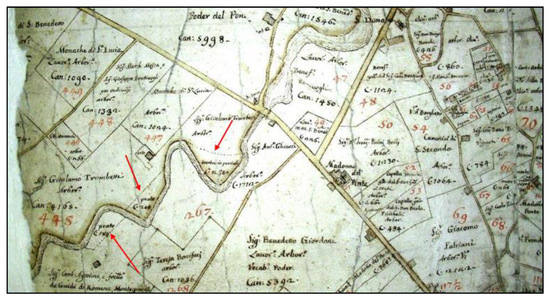
Figure 16.
The San Donato Creek in the “Ghelli’s Cadastre” (1768). The dotted lines, highlighted by red arrows in the figure, are plans for canalizing the stream, where it states “land in danger” due to frequent flooding affecting this area.
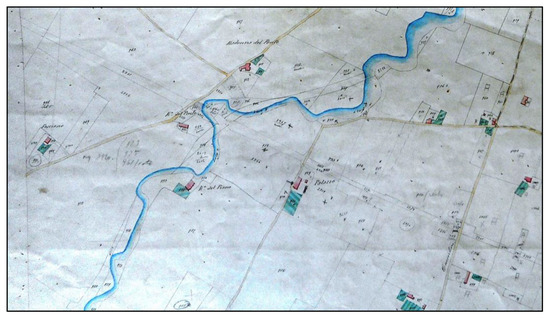
Figure 17.
Extract from the Gregorian Cadastre of the Madonna del Ponte area, redrawn at the end of the 19th century.
Instead, the second hypothesis, which attributes the diversion of the San Donato Creek to natural causes, seems realistically not only possible but probable. The alluvial fan formed by the San Donato Creek has a morphology characterized by a gentle slope, the lowest found in the Gubbio Plain at the mouth of the streams which, crossing the Gubbio hills, form these systems. It is precisely this feature that makes the riverbed extremely mobile: in such cases, even a single flood is sufficient to cause a diversion of the track. It should also be remembered that the alluvial fan of the San Donato Creek, despite its gentle morphology, constitutes, within the Gubbio plain, a divide between the hydrographic basins of the Assino River and the Chiascio River: a diversion of a few degrees could easily have diverted the stream into one or the other catchment area. On the other hand, it is sufficient to observe any “active” fan (i.e., growing by sedimentation; Figure 18) to verify how diversions, even sensitive ones, of the feeder channel can occur very quickly, especially as alluvial fans have low slopes.
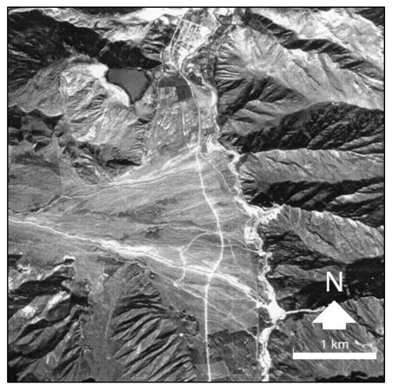
Figure 18.
A typical alluvial fan (Arroyo del Medio, province of Jujuy, northwestern Argentina). The various channels that grow the cone are evident.
In essence, it would be that phenomenon which in geomorphology is defined as “river capture by spill (or overflow)” [50] (Figure 19): a stream, changing direction due to a sudden sedimentary input, can cause its waters to flow into a neighboring hydrographic basin that is different from the one in which it was located. Figure 20 shows an essential geomorphological map of the study area, where the San Donato fluvial perfectly follows what is reported in the sketch of Figure 19.
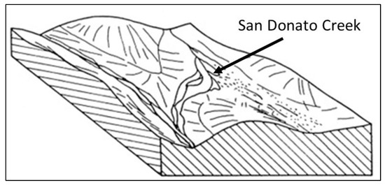
Figure 19.
Fluvial capture by spill (or overflow). From [50], modified.
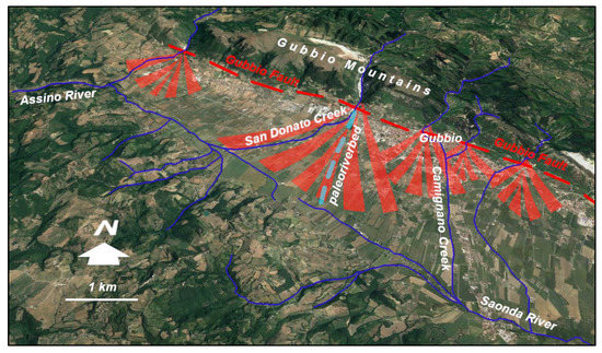
Figure 20.
Geomorphological sketch of the Gubbio Plain.
This remains the most probable hypothesis and seems to be supported by an archival document.
In “Memoirs” (written from 1557 to 1604) by don Paris Montanari, the Gubbio parish priest at the time, consulted in the State Historical Archive, Gubbio Section, it states “1571. I remember that on July 18th the River known as Camignano made a huge flood, and did huge damage by flooding houses and churches, and passed over the bridges of the city: the closest houses along the river, those above St. Biagio, those of the Market, the Macelli, and the Houses of Borgo: and the churches it flooded were St. Biagio, the Mastadella, St. Bernardino, St. Rocco, and the Monastery of Good Jesus: and it carried very large beams, a frightening and terrible thing: and I don Paris was in St. Belardino with some friends of mine”—(Sezione Archivio Storico di Gubbio i.e., State Historical Archive, Gubbio Section—SASG, Fondo Armanni, II.B.13).
The “river known as Camignano” is the one that crosses the city of Gubbio (Figure 3), parallel to, and a short distance from the San Donato Creek which, evidently, suffered the same effects.
Could this be the flood event that caused the diversion of the route? The date should also be noted: 18 July 1571, indicated by don Paris as the day on which the event occurred. Georgi must have already drawn up his map if, as Allegrucci says [25], precisely on that year the cartographer went to Venice to have the “coppers” of his work engraved.
Beyond the fact that the diversion of the San Donato Creek can be attributed to this specific event described by don Paris Montanari, documentary evidence highlights an important element, namely flood events in the streams that cross the Gubbio Mountains, were certainly present in that historical period (see also Table 2). This is no longer the case today, thanks to the works of hydraulic regulation of the running waters and the arrangement of the slopes carried out in later times.
Table 2.
List of the most important flood events in the Gubbio area which are traced in the historical documentation. The most cited refer to the Camignano River, as it crosses the city of Gubbio, but the references often extend to the surrounding rivers.
As evidence that such flood events were frequent in the Gubbio Plain, the text of the epigraph is reported, affixed after two important alluvial events in Camignano River occurred. One occurred in the aedicule (already mentioned, located on the right bank of the Camignano River and the other in the district of San Martino, which is located within the historic center of Gubbio) (Figure 21). The citizens of Gubbio thank the effigy of the Madonna with the words, translated from the Italian: “To you, Great Virgin Help of Christians who, motionless in this poor location among the ruins of repeated floods in 1859 and 1866, wanted to save the lives of so many citizens in danger, the elite of the districts, as to a dear, most vigilant, compassionate mother, as a sign of filial gratitude, this memory they put.”
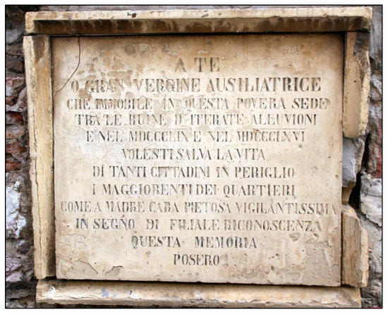
Figure 21.
Detail of the aedicule shown in Figure 9, which highlights the epigraph located at the base.
Such events could easily have ben produced between 1570 and 1582. The phenomenon of “capture by overflow” was identified based on the comparison between Georgi’s Map and the current situation.
4. Discussion
From the data and results described, different conditions and morphogenetic factors emerge between the period under consideration (16th century) and the current situation. Different from past periods, the streams flowing from the Gubbio Mountains towards the Gubbio basin present a regime strongly controlled by the riverbed and slope arrangements. This, presumably, only began in the last century, up to the paving of the Camignano River, which took place near the end of the 1970s (Figure 22).
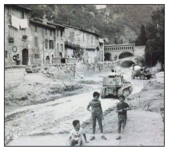
Figure 22.
The paving works of the riverbed of the Camignano Creek (around the end of 1970s) in a photo from the time.
Proof of this is the photographic evidence that, already from the 1800s and up to the 1950s, showed slopes bare of vegetation and affected by debris flows (Figure 23 and Figure 24), such as that of 1341, described by Luongo [38]. The detrital material easily poured into the streams, which presented a greater solid transport than the current one (Figure 25). Moreover, in the absence of regulation of rainwater and runoff on the slopes, the rivers were subject to sudden floods, causing frequent and severe damage to the structures and the resident population. Historical testimonies document these conditions of hydrogeological risk (Table 2).
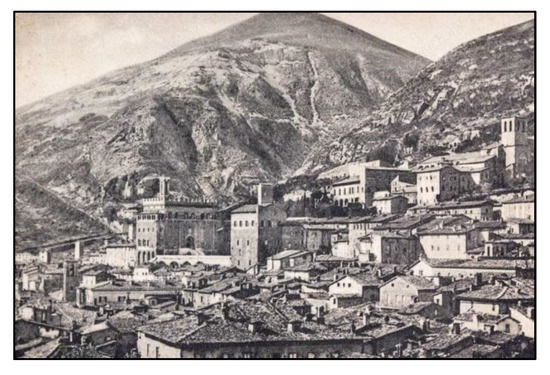
Figure 23.
The slopes of the Gubbio Mountains, substantially bare of vegetation, as they appeared in a postcard from the 1950s.
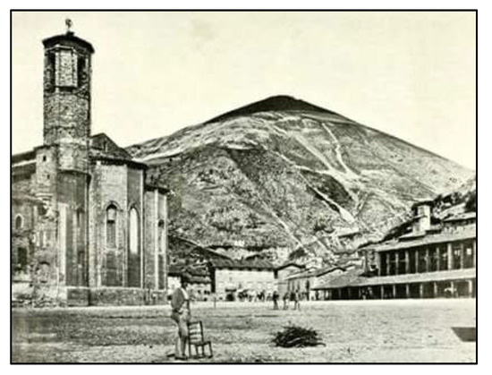
Figure 24.
The detrital material was once easily mobilizable, considering the absence of vegetation and the steep slopes, so as to allow the triggering of debris flows that poured into the streams.
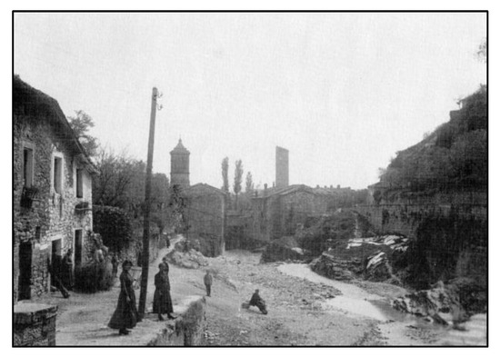
Figure 25.
The streams (in the photo the Camignano Creek in the urban reach of Gubbio) were still subject to strong solid transport of detrital material coming from the bare and steep valley sides in the 1800s. The point of view is from upstream towards downstream.
From the point of view of hydraulic risk, the present situation is profoundly different. The afforestation carried out on the hills facing the city (Figure 26) has had the effect of greatly reducing the possibility of triggering debris flows and, above all, has increased the run-off time and the concentration time within the hydrographic basins of the streams flowing into the lowland area, effectively preventing the onset of catastrophic alluvial events such as the one described by don Paris Montanari in his memoirs. The channeling and construction of embankments in the river reaches of the plain have to be added (as well as the paving of the stream which crosses the city of Gubbio, the Camignano River), which have allowed for greater hydraulic efficiency of the outflow sections, thus avoiding inundation and flooding in the urban reaches.
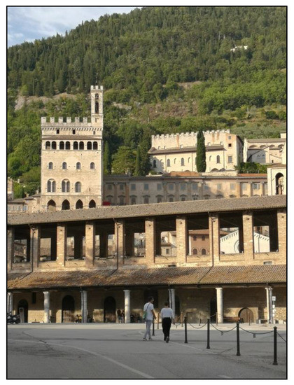
Figure 26.
Gubbio at present. The slopes of the Gubbio Mountains appear today densely revegetated.
Profound changes of the landscape, the evidence of which was made possible precisely by the historical-cartographic and documentary analysis.
5. Conclusions
Georgi’s Map, which depicts the territory of Gubbio (Umbria, Central Italy) at the end of the 16th century, shows a design of the hydrographic network that is partly different from the current one. In particular, the San Donato Creek, today a left tributary of the Assino River in the northern portion of the Gubbio basin, is represented in this map as a tributary of the Saonda River, which belongs to another hydrographic basin, that of the Chiascio River, which occupies the central-southern portion of the basin itself.
The investigation carried out through direct surveys in the field, also with the support of the observation of satellite images, seems to confirm what Georgi has represented. This hypothesis is also supported by other elements, thanks to the excavations carried out for the construction of a new cult building, precisely in the hypothetical direction of flow of the paleo-riverbed of the San Donato Creek. These, in fact, have brought to light a sedimentary body of evident fluvial origin and an archaeological find, in particular a votive aedicule, dating back to the 15th century, which are similar to those that are still present today along the banks of the streams in the territory.
Furthermore, the study has allowed us to hypothesize the period in which this variation of the hydrographic network may have occurred, and the causes that may have produced it.
About this period, the comparison between Georgi’s Map and the ones created subsequently allowed us to identify a precise time slice between 1570 (presumed date of creation of the Georgi’s Map) and 1582 (date in which it was completed the mural painting by Egnatio Danti, preserved in the Vatican Museums, which represents a drawing of the hydrographic network substantially like the current one).
With regard to the causes of the modification of the track of the San Donato Creek, this suggests natural processes, in particular a diversion of the stream (river capture by overflow) induced by an alluvial event. This seems to be confirmed by the chronicles of time that highlight more severe hydrogeological risk conditions, characterized by a higher frequency of flood events than the current situation.
Therefore, a substantial evolution of the morphogenetic processes (fluvial and slope) in the study area should be highlighted, due both to the afforestation carried out along the slopes of the Gubbio Mountains and to the numerous surface water regulation interventions, both carried out during the 20th century. These have greatly reduced erosion processes, the triggering of debris flows, and the consequent solid transport of the streams that drain the slopes of the Gubbio hills, contributing to a decisive mitigation of the hydrogeological risk connected to the flooding phenomena of the lowland area.
Therefore, the present study is an excellent example of the validity of a multidisciplinary study method in the reconstruction of landscape evolution in areas of ancient and persistent human presence.
Author Contributions
Conceptualization, C.C., E.A.S., F.P. and U.E.S.; methodology, C.C., E.A.S. and F.P.; software, C.C.; validation, C.C., E.A.S., F.P. and U.E.S.; field investigation, C.C., E.A.S., F.P. and U.E.S.; archival researches, F.P. and E.A.S.; resources, C.C.; data curation, C.C., E.A.S., F.P. and U.E.S.; writing—original draft preparation, C.C., E.A.S. and F.P.; writing—review and editing, C.C., E.A.S. and F.P.; visualization, C.C., E.A.S. and F.P.; supervision, C.C., E.A.S. and F.P.; project administration, C.C.; funding acquisition, C.C. All authors have read and agreed to the published version of the manuscript.
Funding
This research received no external funding; the APC was funded by Corrado Cencetti with resources at his disposal furnished by Department of Physics and Geology, University of Perugia.
Data Availability Statement
All data are freely available in the State Archives and National Libraries mentioned in the text.
Acknowledgments
The authors thank Fabrizio Cece for providing some documentary data.
Conflicts of Interest
The authors declare no conflict of interest.
References
- Williams, G.P.; Wolman, M.G. Downstream Effects of Dams on Alluvial Rivers; U.S. Geological Survey Professional Paper; US Government Printing Office: Washington, DC, USA, 1984. [Google Scholar]
- Wyżga, B. River response to channel regulation: Case study of the Raba River, Carpathians, Poland. Earth Surf. Process. Landf. 1993, 18, 541–556. [Google Scholar] [CrossRef]
- Surian, N.; Rinaldi, M. Morphological response to river engineering and management in alluvial channels in Italy. Geomorphology 2003, 50, 307–326. [Google Scholar] [CrossRef]
- Surian, N.; Rinaldi, M. Channel adjustments in response to human alteration of sediment fluxes: Examples from Italian rivers. In Sediment Transfer through the Fluvial System; Golosov, V., Belyaev, V., Walling, D.E., Eds.; IAHS Publ.: Moscow, Russia, 2004; Volume 288, pp. 276–282. [Google Scholar]
- Romano, S.; Cozzi, M. Cambiamenti nell’uso del suolo: Analisi e comparazione di mappe storiche e recenti. Il caso della Valle dell’Agri, Basilicata, Italia. Aestimum 2007, 51, 63–89. [Google Scholar] [CrossRef]
- Gardi, C.; Dall’Olio, N.; Salata, S. L’insostenibile Consumo di Suolo; EdicomEdizioni: Monfalcone, Italy, 2013. [Google Scholar]
- Consumo di Suolo, Dinamiche Territoriali e Servizi Ecosistemici; Report SNPA 32/22; Munafò, M., Ed.; ISPRA: Roma, Italy, 2022. [Google Scholar]
- Bravard, J.P.; Kondolf, G.M.; Piegay, H. Environmental and societal effects of channel incision and remedial strategies. In Incised River Channels: Processes, Forms, Engineering and Management; Darby, S.E., Simon, A., Eds.; Wiley: London, UK, 1999; pp. 303–341. [Google Scholar]
- Liebault, F.; Piegay, H. Assessment of channel changes due to long-term bedload supply decrease, Roubion River, France. Geomorphology 2001, 36, 167–186. [Google Scholar] [CrossRef]
- Surian, N. Effects of human impact on braided river morphology: Examples from Northern Italy. In Braided Rivers; Smith, G.H., Best, J.L., Bristow, C., Petts, G.E., Eds.; IAS Special Publication 36; Wiley-Blackwell: Hoboken, NJ, USA, 2006; pp. 327–338. [Google Scholar]
- Da Canal, M.; Comiti, F.; Surian, N.; Mao, L.; Lenzi, M.A. Studio delle variazioni morfologiche del F. Piave nel Vallone Bellunese durante gli ultimi duecento anni. Quad. Di Idronomia Mont. 2007, 27, 259–271. [Google Scholar]
- Surian, N.; Ziliani, L.; Cibien, L.; Cisotto, A.; Baruffi, F. Variazioni morfologiche degli alvei dei principali corsi d’acqua veneto-friulani negli ultimi 200 anni. Alp. Mediterr. Quat. 2008, 21, 279–290. Available online: https://amq.aiqua.it/index.php/amq/article/view/361 (accessed on 2 March 2023).
- Koeman, C. The study of early maps: Methodology—Levels of Historical Evidence in Early Maps (With Examples). Int. J. Hist. Cartogr. 1968, 22, 75–80. [Google Scholar] [CrossRef]
- Kent, A.J. The Value of Historical Maps: Art, Accuracy and Society. Doctoral Thesis, Oxford Brookes University, Oxford, UK, 1998. [Google Scholar] [CrossRef]
- Cencetti, C. La cartografia storica come strumento per lo studio dell’evoluzione degli alvei fluviali. In Proceedings of the 6a Conferenza Nazionale ASITA, Perugia, Italia, 5–8 November 2002; Volume 1, pp. 757–762. [Google Scholar]
- Zámolyi, A.; Székely, B.; Draganits, E.; Timár, G. Historic maps and landscape evolution: A case study in the Little Hungarian Plain. In Proceedings of the European Geosciences Union General Assembly, Vienna, Austria, 19–24 April 2009. [Google Scholar]
- Lambrick, G.; Hind, J.; Wain, I. Historic Landscape Characterisation in Ireland: Best Practice Guidance; The Heritage Council of Ireland Series: Dublin, Ireland, 2013. [Google Scholar]
- Coomans, T. Mapping Landscapes in Transformation: Multidisciplinary Methods for Historical Analysis; Leuven University Press: Leuven, Belgium, 2019. [Google Scholar]
- Sobczynski, D.; Karsznia, I. Landscape evolution in the area of Kazimierski Landscape Park. Pol. Cartogr. Rev. 2019, 51, 81–94. [Google Scholar] [CrossRef]
- Rombai, L. Problems related to the use of the history cartography. Boll. Ass. It. Cart. 2010, 138, 69–89. [Google Scholar]
- Statuto, D.; Cillis, G.; Picuno, P. Using Historical Maps within a GIS to Analyze Two Centuries of Rural Landscape Changes in Southern Italy. Land 2017, 6, 65. [Google Scholar] [CrossRef]
- Branduini, P.; Laviscio, R.; L’Erario, A.; Toso, F.C. Mapping Evolving Historical Landscape System. In Proceedings of the 2nd International Conference of Geomatics and Restoration, Milan, Italy, 8–10 May 2019; pp. 277–284. [Google Scholar]
- Picuno, P.; Cillis, G.; Statuto, D. Investigating the time evolution of a rural landscape: How historical maps may provide environmental information when processed using a GIS. Ecol. Eng. 2019, 139, 105580. [Google Scholar] [CrossRef]
- Piovan, S. Historical Maps in GIS. In The Geographic Information Science & Technology Body of Knowledge, 1st Quarter 2019 Ed.; Wilson, J.P., Ed.; Digital version; UCGIS: Ithaca, NY, USA, 2019. [Google Scholar] [CrossRef]
- Allegrucci, F. Lettura cartografica dell’Eugubino dalla Carta del Georgi a quella del Coronelli. In Gubbio e la sua Storia – Sez. III. Gubbio nel Rinascimento; Biblioteca Sperelliana: Gubbio, Italia, 1999; 7p. [Google Scholar]
- Ambrosetti, P.; Basilici, G. Il Plio-Pleistocene Umbro. In Guide Geologiche Regionali. Appennino Umbro-Marchigiano (Società Geologica italiana), 1st ed.; BE.MA.: Milano, Italy, 1994; pp. 46–47. [Google Scholar]
- Elter, P.; Giglia, G.; Tongiorgi, M.; Trevisan, L. Tensional and compressional areas in the recent (Tortonian to Present) evolution of the Northern Apennines. Boll. Geofis. Teor. Appl. 1975, 65, 3–18. [Google Scholar]
- Carmignani, L.; Kligfield, R. Crustal extension in the Northern Apennines: The transition from compression to extension in the Alpi Apuane core complex. Tectonics 1990, 9, 1275–1303. [Google Scholar] [CrossRef]
- Boccaletti, M.; Cerrina Feroni, A.; Martinelli, P.; Moratti, G.; Plesi, G.; Sani, F. L’alternanza distensione-compressione nel quadro evolutivo dei bacini neogenici dell’Appennino Settentrionale. In Studi Preliminari All’acquisizione Dati del Profilo CROP 03 Punta Ala—Gabicce; Pialli, G., Barchi, M., Menichetti, M., Eds.; Studi Geologici Camerti; Università di Camerino: Camerino, Italy, 1991; pp. 187–192. [Google Scholar]
- Cinque, A.; Patacca, E.; Scandone, P.; Tozzi, M. Quaternary kinematic evolution of the Southern Apennines. Relationships between surface geological features and deep lithospheric structures. Ann. Geofis. 1993, 36, 249–260. [Google Scholar] [CrossRef]
- Amato, A.; Selvaggi, G. Terremoti crostali e sub-crostali nell’Appennino settentrionale. In Studi Preliminari All’acquisizione Dati del Profilo CROP 03 Punta Ala—Gabicce; Pialli, G., Barchi, M., Menichetti, M., Eds.; Studi Geologici Camerti; Università di Camerino: Camerino, Italy, 1991. [Google Scholar]
- Boncio, P.; Brozzetti, F.; Ponziani, F.; Barchi, M.; Lavecchia, G.; Pialli, G. Seismicity and extensional tectonics in the northern Umbria-Marche Apennines. Mem. Soc. Geol. It 1998, 52, 55. [Google Scholar]
- Barchi, M.; Beltrando, M. The Neogene-Quaternary evolution of the Northern Apennines: Crustal structure, style of deformation and seismicity. J. Virtual Explor. 2010, 36, 1–24. [Google Scholar] [CrossRef]
- Collettini, C.; Barchi, M.; Chiaraluce, L.; Mirabella, F.; Pucci, S. The Gubbio fault: Can different methods give pictures of the same object? J. Geodyn. 2003, 36, 51–66. [Google Scholar] [CrossRef]
- Menichetti, M.; Minelli, G. Extensional tectonics and seismogenesis in Umbria (Central Italy) the Gubbio area. Boll. Soc. Geol. It. 1991, 110, 857–880. [Google Scholar]
- Cattuto, C.; Cencetti, C.; Gregori, L. Elementi geomorfologici dell’area compresa tra l’Umbria nord-orientale e la regione marchigiana. Mem. Descr. Della Carta Geol. D’italia 1989, 39, 37–44. [Google Scholar]
- Cattuto, C.; Cencetti, C.; Gregori, L. Il Plio-Pleistocene nell’area medio-alta del bacino del F. Tevere: Possibile modello morfotettonico. Studi Geol. Camerti 1992, 103–108. [Google Scholar]
- Cencetti, C. Evoluzione del reticolo idrografico in un tratto umbro-marchigiano dello spartiacque principale dell’Appennino. Geogr. Fis. Dinam. Quat. 1988, 11, 11–24. [Google Scholar]
- Sestini, A. Sull’origine della rete idrografica e dei bacini intermontani nell’Appennino centro-settentrionale. Riv. Geogr. It. 1950, 57, 249–256. [Google Scholar]
- Desplanques, H. Carte du peuplement dans la région de Gubbio au XVIe siècle. Mediterranèe 1963, 4, 5–13. [Google Scholar] [CrossRef]
- Allegrucci, F. La popolazione della diocesi di Gubbio in una carta topografica del XVI secolo. Propos. E Ric. 1985, 15, 51–60. [Google Scholar]
- Armeni, C.; Falcucci, C. Museo Comunale di Gubbio. Incisioni; Electa: Firenze, Italy, 1993; 156p. [Google Scholar]
- Graziani, M.O. La Carta del Georgi; L’Arte Grafica: Gubbio, Italy, 2005; 28p. [Google Scholar]
- Menichetti, P.L. Storia di Gubbio Dalle Origini all’Unità d’Italia; Petruzzi Editore: Città di Castello, Italy, 1987; Volume 2, pp. 94–95. [Google Scholar]
- Charalambous, K.; Bruggeman, A.; Bakirtzis, N.; Lange, M.A. Historical Flooding of the Pedieos River in Nicosia, Cyprus. Water Hist. 2016, 8, 191–207. [Google Scholar] [CrossRef]
- Sannipoli, E.A. Documenti inediti su Jacopo Bedi pittore eugubino (1a parte). Gubbio Arte 1994, 12, 21–23. [Google Scholar]
- Paci, R. La crisi del Comune popolare di Gubbio nel Cinquecento. Quad. Stor. Delle Marche 1967, 2, 457–507. [Google Scholar]
- Biscarini, P.E.P. Splendore e decadenza di una città: Gubbio tra la fine del Quattrocento e la prima metà del Cinquecento. Alcune note di storia. In Proceedings of the La maiolica Italiana del Cinquecento. Il Lustro Eugubino e L’istoriato del Ducato di Urbino, Gubbio, Italy, 21–23 September 1998; Centro Di: Firenze, Italy, 2002; pp. 31–48. [Google Scholar]
- Cece, F.; (Independent Researcher, Gubbio, Italy). Personal communications. 2020. [Google Scholar]
- Panizza, M. Elementi di Geomorfologia; Pitagora: Bologna, Italy, 1978; 188p. [Google Scholar]
- Luongo, A. Gubbio nel Trecento. Il comune Polare e la Mutazione Signorile (1300–1404); Viella: Roma, Italy, 2016; 726p. [Google Scholar]
- Cece, F. Memorie di don Paris Montanari. In Il Diario di Giacomo Armanni (1622–1631). Gubbio Negli Ultimi Dieci Anni del Ducato di Urbino; Self-Published: Gubbio, Italy, 2006; pp. 53–62. [Google Scholar]
- Cece, F. Luigi Lucarelli. Memorie; Media Video: Gubbio, Italy, 2011; 400p. [Google Scholar]


Disclaimer/Publisher’s Note: The statements, opinions and data contained in all publications are solely those of the individual author(s) and contributor(s) and not of MDPI and/or the editor(s). MDPI and/or the editor(s) disclaim responsibility for any injury to people or property resulting from any ideas, methods, instructions or products referred to in the content. |
© 2023 by the authors. Licensee MDPI, Basel, Switzerland. This article is an open access article distributed under the terms and conditions of the Creative Commons Attribution (CC BY) license (https://creativecommons.org/licenses/by/4.0/).