Article

Study on Spatial–Temporal Evolution Characteristics and Restrictive Factors of Urban–Rural Integration in Northeast China from 2000 to 2019

1
School of Geographical Sciences, Northeast Normal University, Changchun 130024, China
2
School of Architecture, Changchun Institute of Technology, Changchun 130021, China
*
Author to whom correspondence should be addressed.
Land 2022, 11(8), 1195; https://doi.org/10.3390/land11081195
Submission received: 11 July 2022 / Revised: 26 July 2022 / Accepted: 27 July 2022 / Published: 29 July 2022
(This article belongs to the Special Issue Sustainable Rural Transformation under Rapid Urbanization)

Abstract

:
With the rapid development of urbanization and the widening gap between urban and rural areas, how to effectively enhance the balanced development of urban and rural areas as well as promote the integrated development of urban and rural areas have become heated topics. Based on the basic theory of urban–rural integration and spatial balance, this paper establishes a comprehensive evaluation system. Using a coupling coordination model and an obstacle degree model, this paper selects 32 indicators from aspects of economy, society and ecology to measure the development level of urban–rural integration in 34 prefecture-level cities in Northeast China from 2000 to 2019. We also analyze the spatial pattern, evolution type characteristics and obstacle factors of urban–rural relations. The results show that: (1) The growth rate of urban development in Northeast China is higher than that of rural development. Except for rural ecology, all dimensions of urban and rural areas have increased year by year, but there are large spatial differences within the region. (2) The urban–rural integration development level of Northeast China is growing constantly and the types of urban and rural coordination are all rising to a higher level. Areas with high urban–rural coordination levels are concentrated in the Harbin–Changchun urban agglomeration and the central and southern Liaoning urban agglomeration, with obvious agglomeration effects. (3) In the coordinated development of urban and rural areas, the restrictive degree of the rural social subsystem was higher than that of the urban subsystem. The restrictive factors in the coordinated development of urban and rural areas are relatively stable, and include per capita consumption expenditure, per capita public budget expenditure, books in public libraries per thousand people, etc. (4) The functions of rural social elements should be enhanced, and the social urban–rural integrated development mechanism should be established to promote the integrated development of urban and rural society.

1. Introduction

The urban–rural relationship is a form of common connection and interaction existing between urban and rural areas derived from the way they interact, influence, and restrict each other, emerging as a major challenge for contemporary economic and social development [1]. Western countries were the first to pay attention to the urban–rural relationship and how to coordinate the development of urban and rural areas, and carried out beneficial practices such as agricultural modernization and rural surplus labor transfer [2,3]. In the past two decades, the gap between urban and rural areas in China has been alleviated gradually, but the fundamentals of the relatively larger urban–rural gap have more or less remained unchanged in the areas with relatively backward economic development [4]. This limited and inequitable development in urban and rural areas is one of the main contradictions of China’s social development. The urban–rural gap represents a fundamental characteristic of China’s urban–rural relationship, and tends to be the most critical manifestation of regional disparity under the primary and secondary stages of social development [5], which is primarily reflected in urban and rural income and consumption, education and health care, other social security aspects, as well as government public investments. The emergence of these problems will continue to affect the happiness index of urban and rural residents. Under the impact of the COVID-19 pandemic and the economic policy of trade protectionism, economic globalization has entered a new stage, and China has revamped its development mode [6]. To cope with the challenges of globalization, China has introduced two principal strategies of new urbanization and rural revitalization and urban–rural integrated development. Bridging the gap between urban and rural areas and striving for a fresh urban–rural relationship in the new era have been China’s primary objectives to achieve efficient coordinated regional development and also serve as an inevitable choice for China’s transformation from an advanced stage of urbanization to high-quality development [4].
The rapid expansion of cities and the increased demand for consumption and services from residents has put pressure and challenges on the sustainable development of rural areas [7]. For humans, the economic, social or ecological aspects of urban–rural relations are fundamental factors that intuitively influence sustainable urban–rural development. The urban–rural dual structure of Northeast China has been long-standing, with considerable spatial differences in the urban–rural relationship of prefecture-level cities from coastal to inland and from east to west [8]. The collapse in the overall economic environment in Northeast China gave rise to myriad urban problems, rural problems and urban–rural problems, which are reflected in the expansion of urban land, the reduction of urban job opportunities, the decline in rural agricultural land, the decrease in rural labor force, the inadequacy of urban and rural vitality, the widening gap between urban and rural areas, the unbalanced development between urban and rural areas and the extreme institutional barriers between urban and rural areas that exist even now. Therefore, there is an urgent need to explore the characteristics and the obstacle mechanisms of the evolutionary process of urban–rural relationship development in Northeast China, and to propose strategies to optimize the development of urban–rural integration, which is of great significance for comprehensive high-quality development and improving people’s livelihood security.

2. Literature Review and Theoretical Framework

2.1. Urban–Rural Relationships and Integrated Urban–Rural Development

The concepts of a city (urban areas) and a village (rural areas) are defined from a broad perspective, involving population, economy, lifestyle, culture and other aspects. A city is the product of social productivity development up to a certain stage; the term refers to the settlement of a non-agricultural population engaging in non-agricultural practices, whereas, being a concept closely related to city, village refers to the settlement of a rural population working predominantly for agricultural production. There is no clear spatial boundary between a city and a village, and they behave as two spatially integrated areas that assume different functions but complement each other as well. Considering the basic form of relationships in the development of human society, the urban–rural relationship covers urban–rural economic relationships, social relationships, class relationships, ecological environment relationships, cultural relationships, location relationships, etc. [1]. In this paper, we define the urban–rural relationship as the spatial reflection of the interactions and mutual influences extended between the urban and rural systems in economic, social, and ecological dimensions.
The relationship between urban and rural areas has progressed with advancing productivity, while undergoing a process of evolution from primitive symbiosis to antagonism, and finally to integrated development. Influenced by the economic and social background and policy orientation, China’s contemporary urban–rural relationship framework has undergone a shift from “overall urban–rural planning” to “urban–rural co-ordination”, followed by primary urban–rural integration and finally to “advanced urban–rural integration” [9]. In essence, urban–rural integration development is the sustainable development within the scope of urban and rural areas. The urban–rural integrated development cited in this study hints at the hypothesis of sustainable development, advocating the complementary and balanced development between urban and rural areas, and creating the state of “differences with no gaps and barrier-free movement” between urban and rural areas [10], thereby attaining the ultimate urban–rural relationship goal of accomplishing urban–rural integrated development via high-quality and stable development of urbanization.

2.2. Literature Review

With the progress of economy and society, there has been increasing research on the urban–rural relationship. Western studies primarily focus on the evolution and theoretical construction of the urban–rural relationship. The earliest study exploring the relationship between urban and rural areas can be traced back to the notion of urban and rural development in the theory of utopian socialism proposed by utopian thinkers [11]. Adam Smith [12] reviewed the natural order and mode of evolution of urban–rural relations in The Wealth of Nations, suggesting that the urban and rural areas support and refine each other [13]. Marx described the phased development process of the urban–rural relationship as going from antagonism to unity, and then to integration [14], emphasizing that urban–rural integration forms an inevitable part of human social development. Subsequently, theories such as garden city [15], satellite city, broadacre city and organic evacuation [16] enriched the pool of theoretical research on the urban–rural relationship. Western scholars have also evaluated the urban–rural gap in developing countries and the corresponding problems existing in the urban–rural integration development process, proposing “urban–rural integration”, “regional network” [17] “urban–rural dual structure theory” [18], “urban bias theory” and “urban–rural co-development theory”, among other such theories [19]. Based on urbanization, Western scholars have examined the practical paradigm of urban–rural integration, and formulated a regional concept of simultaneous occurrence of urban and rural behavior within the same geographical area. Western scholars have emphasized the research of the interconnection and interaction between urban and rural areas; they have predominantly employed qualitative evaluation methods [20] and opted for a single perspective, such as urban–rural industrial development [21], urban–rural governance network [22] and urban–rural public services [23], while also using single-dimensional indicators, such as urban–rural human capital gap [24], urban–rural agricultural development [25], urban–rural medical service [26] and urban–rural welfare [27] as their research objects. The evaluation system included urban–rural differences from economic, social, spatial and institutional dimensions [28,29], concentrating on the comprehensive analysis of the underlying problems that affected the coordinated development between urban and rural areas in western countries [30,31].
With the advancement of the urban–rural relationship, Chinese scholars have accentuated the theoretical connotation, development mechanism and empirical research involved in urban–rural integration [32], which stands at the juncture of intensification and differentiation [33,34,35]. The essence of urban–rural integration lies in the achievement of coordinated and integrated development between urban and rural areas by virtue of free movement, equity and sharing of urban and rural development factors [1,36], with strong emphasis on the two-way movement of multi-dimensional urban and rural factors, such as population, economy, society, space and environment [37], which not only strengthen the integration between urban and rural areas but also synergistically contribute to the high-quality development of urban and rural areas. The key to integrated development between urban and rural areas is to remove the systemic barriers obstructing the factor movement, structural integration and functional interconnection in the existing urban–rural regional system [38], along with highlighting the urban–rural linkage reforms and expanding the two-way opening channel in the urban–rural integration [39]. To determine the development level of urban–rural integration, some scholars developed an indicator system composed of multiple indicators, such as comparison, catch-up and various state indicators in the dimensions of economy, society, life, ecology and others [40]. The subjective valuation method, together with the objective valuation method and the subject–objective valuation method are adopted to measure the indicators [41,42]. Simultaneously, spatial analysis methods are utilized to examine the spatial evolution characteristics of urban–rural integration development [43]. The geographic detector model and the spatial econometric model are utilized to review the influencing mechanism of urban–rural integration development [44]. The critical foundation for achieving urban–rural integration is regarded to be the reasonable movement of various resource factors between urban and rural systems [45], which contributes greatly to the optimization of economic, social, ecological and other spatial distributions in urban and rural areas, such that the resource factors return to the urban and rural systems, thereby finally facilitating the accomplishment of equivalent development of urban and rural areas [46]. Panel data, remote sensing data and other multi-source data are utilized to efficiently illustrate the development level of urban–rural integration at the national, provincial and municipal levels in China, and it is believed that the integration of people with land can be highly instrumental in boosting the coordinated development of the urban–rural relationship. Based on this, the optimized model for the integrated development of urban and rural areas is proposed [47], and the urban–rural integrated development policies are formulated to reinforce the urban–rural economic interaction and urban–rural exchanges, along with promoting the equalization of public services and infrastructure between urban and rural areas, and establishing a sustainable urban–rural synergetic relationship.
Based on the research progress of the urban–rural relationship in China and abroad, it could be inferred that the existing research has revealed the theoretical hypothesis, practical paradigm, evolution process, measurement method and the specific integration model required for urban–rural relationship development, which has laid a solid theoretical and methodological groundwork for identifying the desirable evaluation method and development trend of urban–rural integration. Nonetheless, there still exist certain shortcomings, such as the insufficient attention given to the integration of urban and rural ecological environments, and the poor analysis of the development mechanism of urban–rural integration. In future, additional efforts should be made to carry out research on urban–rural integration development in combination with the new development trends. Based on the quantitative analysis of urban–rural integration development, in this paper, we commence with the multidimensional perspective of economy, society, and ecology to explore the evolution characteristics of urban–rural integration in Northeast China as well as the correlation between the dimensions and their restrictive factors.

2.3. Theoretical Research Framework and Research Questions

Due to the existing comprehensive understanding of the urban–rural relationship, several advances have been made in the theories on urban–rural integration. The basic theories utilized in this paper include the rural–urban equivalence theory, the regional system theory of the human–space relationship and the spatial equilibrium theory (Figure 1). The theory of urban–rural equivalence enables bridging of the gap between urban and rural areas while strengthening the coordinated economic and social development between urban and rural areas, and hence, achieving the goal of “different types with equivalent value” in urban and rural spaces by means of functional zoning, infrastructure improvement and enhancement of public services. The regional system theory of the human–space relationship suggests that “man” and “land” form a complex and open a giant system in a certain geographical areas, including the natural environment system, social system, economic system and several other systems. The exchange of multiple factors between the systems promotes the evolution of various urban and rural structures and functions, which provides a global system mindset for the study of urban–rural integration. The spatial equilibrium theory takes the balanced development of regional space with “economic–social–ecological” benefits as the guiding ideology, where all the factors can move freely and are reasonably allocated within the region, and the regional comprehensive development level per capita tends to be uniform, thereby illustrating the process and mechanism of urban–rural integration development. The duality of division and conflict between urban and rural development has resulted in “urban problems” and “rural problems”, which essentially are the causal agents of each other and exist with each other. New urbanization and rural revitalization are the two different means to deal with the urban and rural problems and upgrade the quality of urban and rural development [48] since there exists an inevitable internal coupling mechanism between the two [49]. The advanced development stage of the urban–rural relationship is urban–rural integration, which refers to the influence generated by the two-way movement of urban and rural factors on the spatial function as well as on the structure of urban and rural economy, society and ecological environment under the urban and rural equivalent development approach, revealing the process of rural–urban integration development and its spatial dynamic equilibrium. Finally, both urban and rural areas become interdependent and cooperate on an equal footing, creating an inseparable community of urban and rural life based on principles of mutual dependence and equal cooperation.
In this study, urban (city) and rural areas (village) are defined as the two major interconnected systems in the same space, which promote the evolution of development of urban and rural areas through interaction. Against this backdrop, urban areas provide the basic conditions for the integrated development of urban and rural areas and play an instrumental role in endorsing rural development. At the same time, rural areas can support urban areas with land, labor, capital and other production factors. Based on such goals and existing studies on the coordinated development of urban and rural areas, in this paper, we adopt the coupling coordination degree model to measure the coordinated development level of urban and rural areas in Northeast China. The restrictive degree of each factor in the indicator system is estimated through appropriate calculation to analyze the factors restricting the coordinated development of urban and rural areas. In this paper, we have attempted to answer the following questions: (1) What are the development levels of urban and rural areas in Northeast China? (2) What is the evolution process and the pattern characteristics of the coordinated development between urban and rural areas in Northeast China? (3) What problems and obstacles exist in the way of coordinated development between urban and rural areas in Northeast China? The answers to these questions can facilitate a deeper understanding of the development status of the urban–rural relationship in Northeast China in terms of multidimensionality.

3. Research Data and Methods

3.1. Research Region

Northeast China regions are known to be significant in terms of old industrial bases and function as national food security, ecological security and border security [50]. In terms of topography, they are surrounded by mountains on three sides and have open plains in the center. They primarily have black soil and enjoy temperate monsoon climate, warm and rainy summers, and cold and dry winters (Figure 2). From 2000 to 2020, the urban population of Northeast China increased by 11.754 million, while the rural population dropped by 18.1032 million, signifying grave population depletion in the past decade. The outflow population is primarily of higher quality, while the inflow population is of relatively lower quality. The aging rate of Northeast China elevated from 6.61% to 16.39%, demonstrating an increasing aging trend. From 2000 to 2020, the urbanization rate of Northeast China rose from 52.40% to 67.71%, and the national urbanization rate increased from 36.22% to 63.89% during the same period. The urbanization rate of Northeast China has remained higher than the national average, but the growth manifested a slow rate. Northeast China regions are among the regions that are most severely affected by the planned economy in China and are characterized by a poor foundation for the links between urban and rural areas. Since the reform and opening-up campaign in China, minimal or no remarkable progress has been made in the relationship between urban and rural areas owing to the substandard industrialization and urbanization, and urban and rural decline. The prevailing urban–rural dual structure has become a huge hindrance for regional revitalization.

3.2. Data Sources

The data utilized in this paper were mainly taken from China City Statistical Yearbook, Jilin Statistical Yearbook, Heilongjiang Statistical Yearbook and Liaoning Statistical Yearbook, ranging from 2001 to 2020. Certain missing data were taken from the national economic and social development bulletins of the prefecture-level cities in Northeast China in the corresponding years. The data of cultivated land, forest, grassland and water areas were acquired from the Resource and Environmental Science Data Center and Chinese Academy of Sciences (http://www.resdc.cn/ accessed on 10 January 2022), while the basic geographic data were obtained from the 1:4 million database of the National Geomatics Center of China. Due to the unavailability of certain economic and social data about the Greater Khingan Mountains region and Yanbian Autonomous Prefecture, the research units included in this study are the 34 prefecture-level cities in Heilongjiang, Jilin and Liaoning. The administrative boundaries of prefecture-level cities are subject to the associated administrative division standards released by the State Council in 2010. Practically, the central urban areas of prefecture-level cities are identified as urban areas, and the counties and county-level cities under their jurisdiction are identified as rural areas in this paper.

3.3. Establishment of the Indicator System

Under certain social circumstances, specific policies, economy, society and ecological environment can help to determine the state of the urban–rural relationship, which in turn reflects the state of the economy, society and ecological environment in a certain period. With reference to the existing studies in China and abroad, in this paper we define the connotation of the development of the urban–rural relationship from the perspectives of urban–rural equivalence and spatial balanced development, and point out that the coordinated development of the urban–rural relationship is based on a higher level of economic, social and ecological development, and a better coordination between urban and rural areas. For this study, considering the existing theoretical results, various team discussions and solicited suggestions from some peer experts, as well as considering the possibility of acquiring prefecture-level unit data in Northeast China, the urban and rural development level was divided into 32 indicators in the three dimensions of economy, society and ecology, and the multi-dimensional indicator system for the coordinated development of urban and rural areas was established (Table 1). Among them, the urban system forms the basis for the development of urban–rural integration, and the rural system acts as the driver for the stable development of the urban–rural relationship. The level of economic development in urban and rural areas serves as the prerequisite for the integrated development of urban and rural areas; the level of social development in urban and rural areas is the strong assurance for the coordinated development of urban and rural areas; the level of ecological development in urban and rural areas serves as a critical goal of the sustainable and integrated development of urban and rural areas, which functions as the key policy to achieve the required transformation and development of urban and rural areas.

3.4. Research Methods

3.4.1. Degree of Coupling Coordination between Urban and Rural Areas

After using the range standardization method for the dimensionless processing of the indicators in the urban and rural systems, we employed the entropy method in this paper to determine the indicator weight Wij (Table 1). The urban development indicator and the rural development indicator act as the basic indicators used to measure the urban–rural coordination degree. The formula is shown as follows:
f ( u ) = j = 1 n w j x i j
f ( r ) = j = 1 n w j x i j
In the formula: f ( u ) stands for the urban development indicator; f ( r ) represents the rural development indicator. The larger the values of f ( u ) and f ( r ) , the higher the level of urban and rural development, and vice versa.
The integrated development of urban and rural areas is based on the two systems of these areas. In order to attain the high-quality development of urban and rural areas, it is essential to enhance the coupling coordination of the urban and rural systems. Aiming to scientifically reflect the development status of the urban and rural systems, this paper devises the urban–rural coupling model by making use of the coupling principle in physics so as to quantitatively measure the degree of coupling coordination between urban and rural systems. The measurement formula is as follows:
C = 2 f ( u ) × f ( r ) [ f ( u ) + f ( r ) ] 2
In the formula: C stands for the coupling degree and its value range is [0, 1]. f ( u ) and f ( r ) stand for the urban development level and the rural development level, respectively. The larger the value of C, the higher the degree of coupling between the two systems and the better the orderly development, and vice versa.
As the coupling degree only indicates the degree of interaction within the urban and rural systems, and does not categorically characterize the level of interaction between the two systems, the coupling coordination degree model is introduced; the specific calculation formula is as follows:
T = α × f ( u ) + β × f ( r )
α + β = 1
D = C × T
In the formula: D stands for the coupling coordination degree, and T denotes the comprehensive development level of urban and rural areas; α and β represent the undetermined coefficients. In this paper, the urban and rural subsystems are of equal significance and cannot be biased against in the course of urban and rural development, with their constant values around 0.5. In combination with the pragmatic situation, this paper determines the urban–rural coupling coordination degree and type evaluation criteria of Northeast China [41,51] (Table 2).

3.4.2. Restrictive Degree Model

In this study, we adopt the restrictive degree model to evaluate the level of restrictions on single indicators and classified indicators of urban–rural coordination and to measure the chief restrictiveness level faced by each indicator and subsystem of the urban and rural system to the urban–rural coordinated development through the determined ranking of restrictive degree. The calculation formula is as follows:
I i = 1 x i j
Q i = I i × F i i = 1 m I i × F i
S i = i = 1 n Q i
I i stands for the indicator deviation degree, signifying the difference between the optimal target value of the urban–rural coupling coordinated development and the actual value of each indicator, which is generally expressed by 1 x i j . x i j denotes the standardized value of the j indicator in the ith year. Q i is the degree of restrictiveness, presenting the level of influence of each indicator or system on the coordinated development of urban and rural areas in Northeast China. F i stands for the factor contribution degree, expressed by the weight of each indicator, which represents the contribution level of a single indicator towards the overall goal. S i represents the restrictiveness of each sub-goal layer to the urban–rural coupling coordination.

4. Results

4.1. Spatial–Temporal Analysis of Development Levels of Urban and Rural Areas in Northeast China

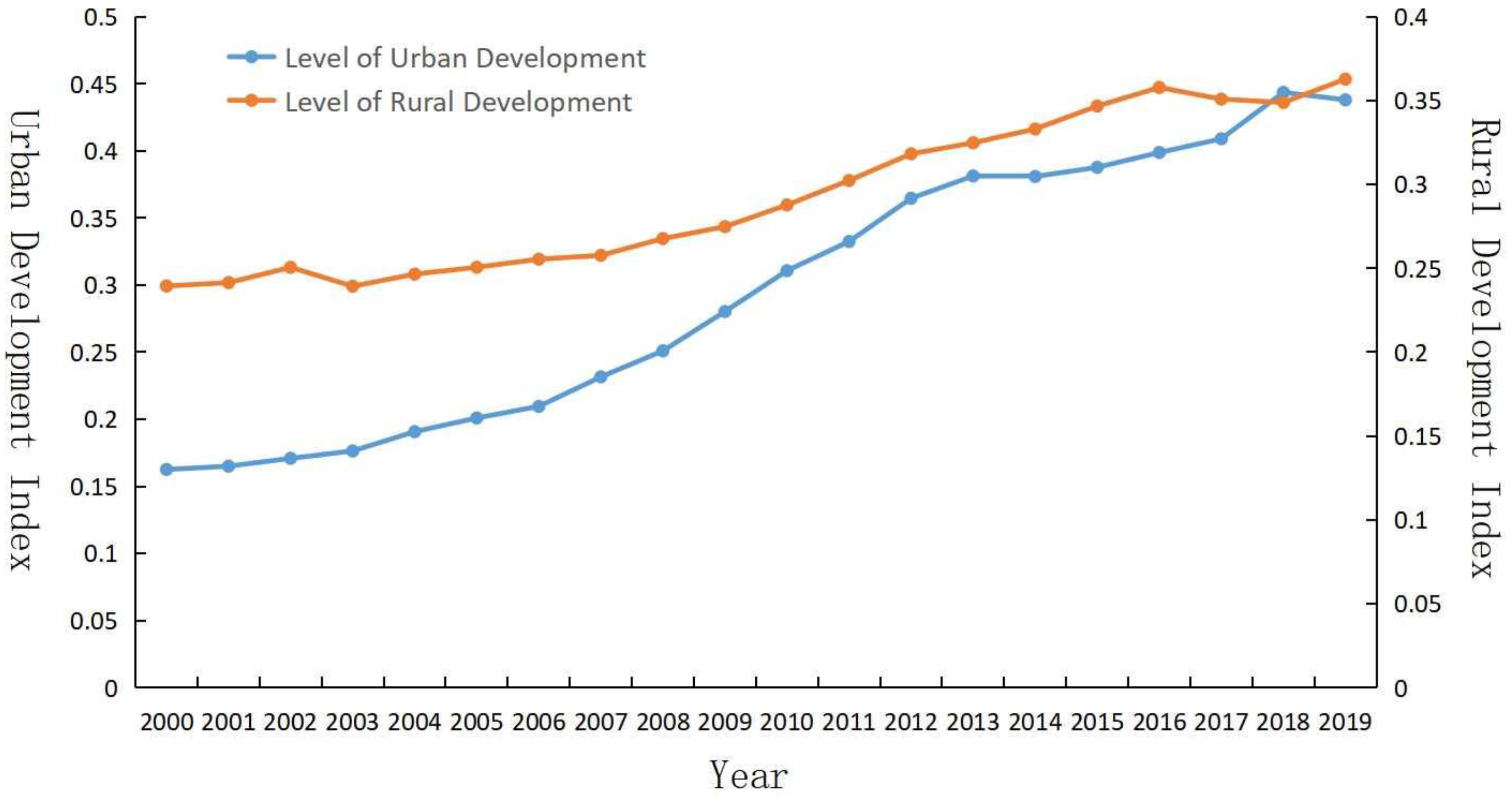
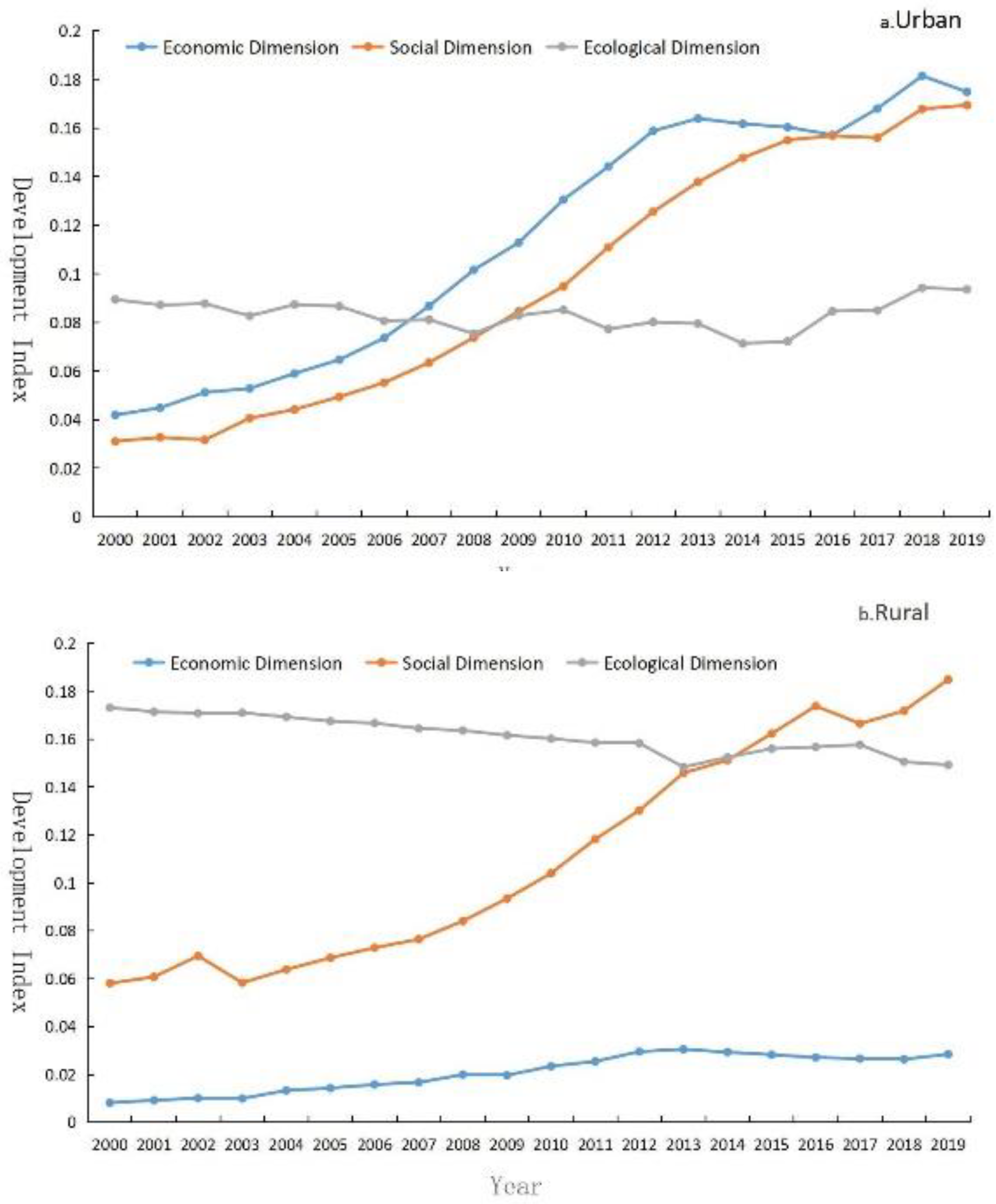
4.1.1. Time Series Variation Characteristics

  • The varying characteristics of the overall development level of urban and rural areas.
The years from 2000 to 2019 witnessed an upward trend in the overall development level of urban areas in Northeast China (Figure 3). According to the growth rate of the urban development level indicator, the urban development level was divided into three stages. The first one is the slow-rising stage (2000–2006): The overall development of urban areas was stable, primarily due to the fact that Northeast China regions are dominated by heavy industry, with a solitary industrial structure; hence, this industry could easily step into the stage of stable development. The second is the rapid-rising stage (2007–2013): A drastic surge was seen in the development level of urban areas, mainly due to the rapid development of urban areas in Northeast China under the support of the revitalizing policy for the old industrial bases in Northeast China. The third is the stage of rising fluctuations (2014–2019), which demonstrated the increasing differences in the urban development levels of prefecture-level cities in Northeast China. From 2000 to 2019, the rural development level indicator of Northeast China illustrated a steady upward trend by and large, with an average annual growth rate of about 2.21%, from 0.239 in 2000 to 0.255 in 2006. The overall growth range was relatively smaller. In 2005, China presented the new rural construction policy and invested in rural infrastructure. In 2006, the rural areas enjoyed some amount of accelerated development, and a net increase of 0.067 from 0.258 in 2007 to 0.325 in 2013, with the average annual growth rate of about 3.361%, and a net increase of 0.030 from 0.333 in 2014 to 0.363 in 2019, with the annual average growth rate of 1.435%. In 2017, China introduced the rural revitalization strategy, which served as a huge contributor for rural development, with an aim to shift from a downward trend of rural development to an upward trend. In 2000, the development level of rural areas stood between 0.1458 and 0.3370, and between 0.2776 and 0.4789 in 2009. At this point, there were relatively stable differences in the development level of rural areas in Northeast China.
2.
The varying characteristics of the development level of urban and rural areas in various dimensions.
From 2000 to 2019, a fluctuating increase in stages was seen in the level of economic and social development of urban areas in Northeast China, and a relatively larger increment was found in the social development level of urban areas (Figure 4). This indicates that more attention was paid to social development and livelihood protection of the people in the due course of urban development. In the past 20 years, the ecological environment development level of the urban areas first showed a decline, followed by an increase, and the quality of the ecological environment exhibited a trend of gradual improvement. It is a pressing priority to strengthen the governance and protection of the ecological environment. In the process of urban development, while the level of economic and social development improved, the ecological environment remained unchanged, which implies the accomplishment of results in the ecological protection and urban environmental governance sector to some extent, but it is vital to keep innovating regarding the governance and reinforcing the protection efforts.
By and large, rural economic development in Northeast China was on the rise, but the average growth rate of the indicator was relatively low, which indicates that the rural economy is labelled with poor development drivers, a solitary agricultural industry and a rural economy in urgent need of transformation and development. The changes in the rural social development indicator appeared roughly the same with the rural development indicator, signifying that the development of rural society has been enhanced, and the investment in infrastructure construction in new rural construction has been conducive for economic and social development in rural areas. The rural ecological development indicator showed a fluctuating declining trend. It continued to fall from 0.173 in 2000. In 2013, it reached 0.148, which was the inflection point. It started to rise to 0.158 in 2017, and then dropped again to 0.149 in 2019, with the average annual growth rate of −0.779%. In rural construction, the economic and social development is considered to be a short-term dividend gained by damaging the ecological environment, and the concept of background protection and sustainable development is not given any importance, thereby resulting in the declining ecological environment.

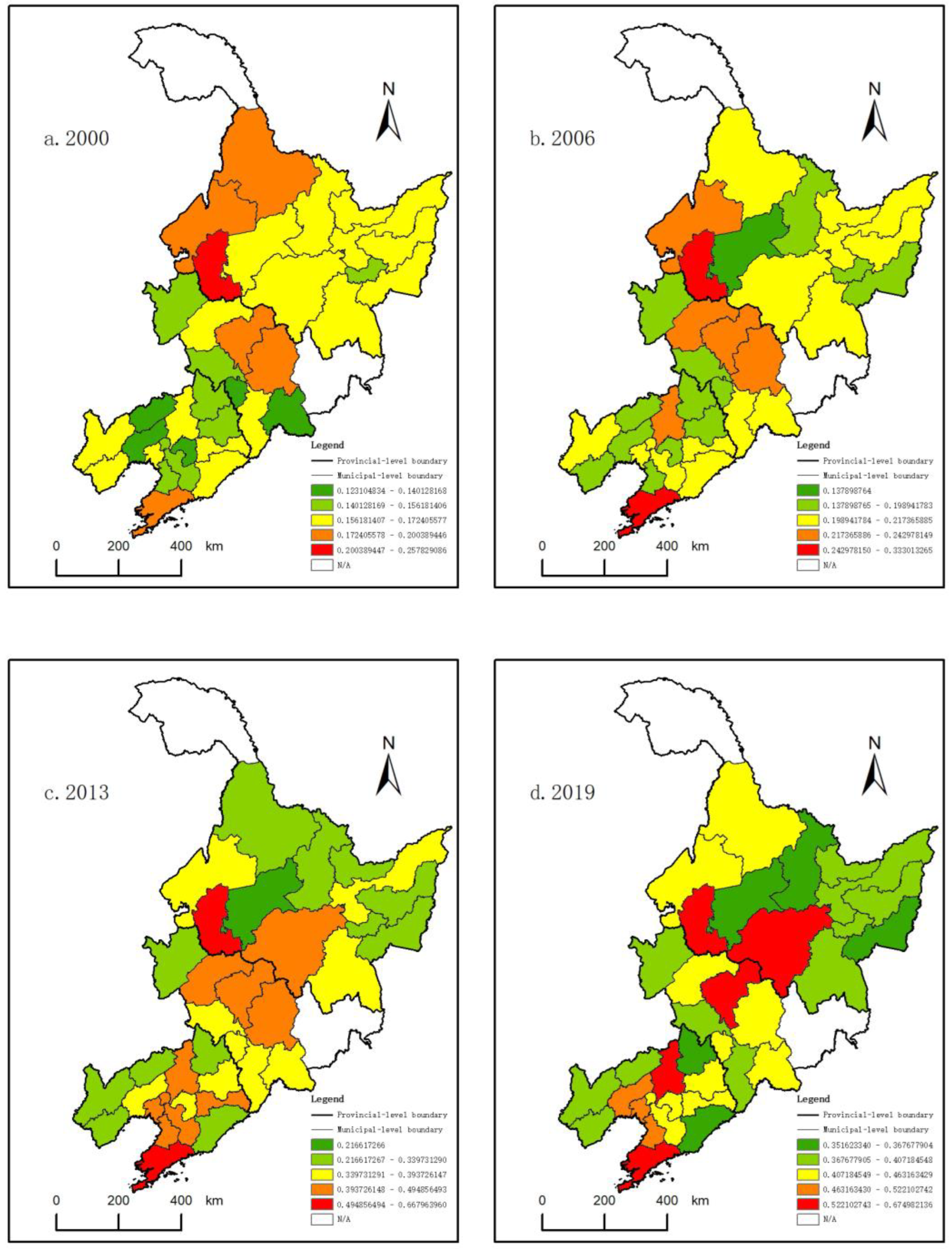
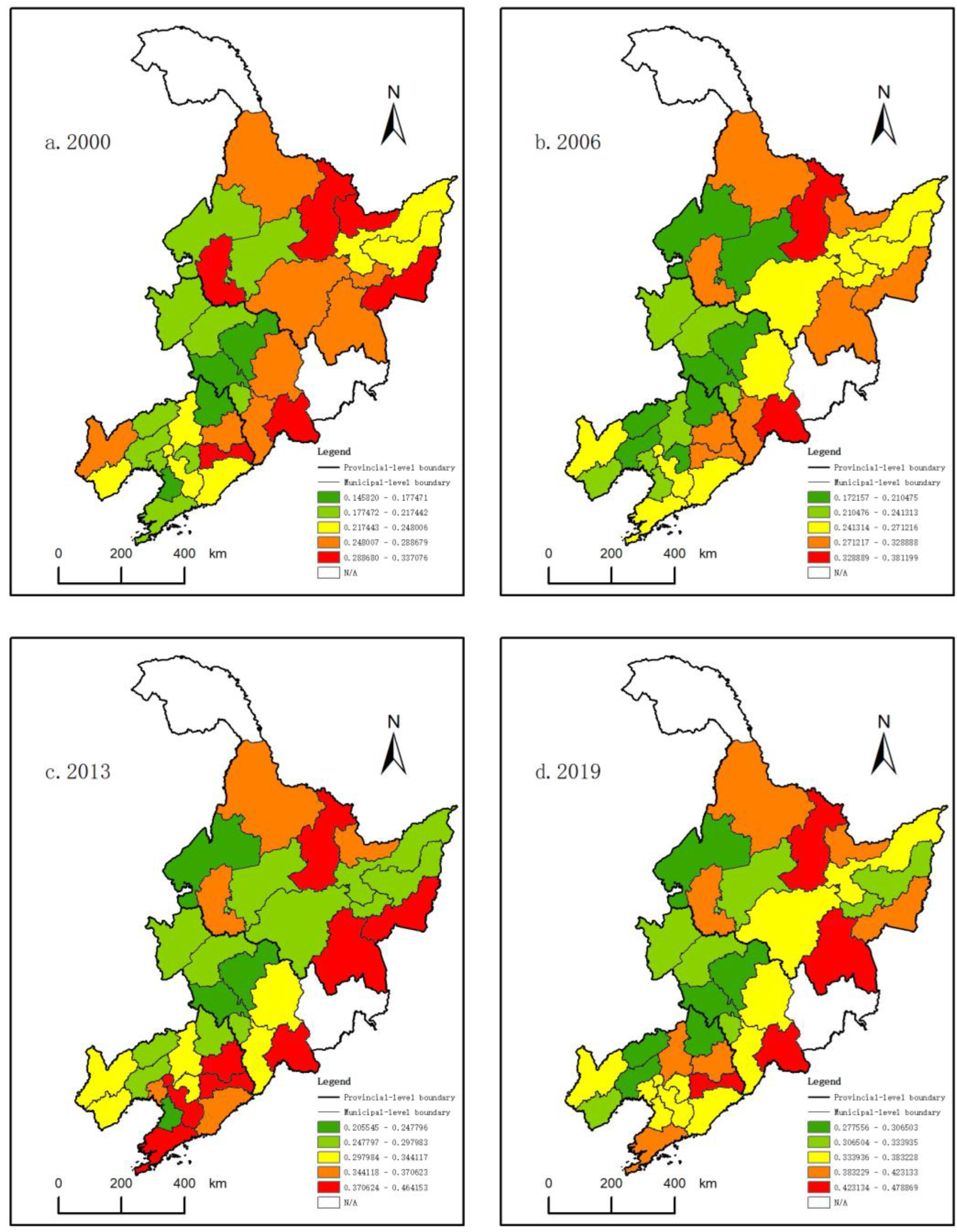
4.1.2. Spatial Change Characteristics

Based on the classification of overall development level of urban areas in Northeast China, the natural fracture method was adopted to divide the urban development indexes of 2000, 2006, 2013 and 2019 into five grades according to the phased characteristics of the evolution of urban and rural development levels (Figure 5). Overall, there are significant spatial differences present in the level of urban development in the four-time indexes. In 2000, there was a spatial pattern of high in the north and low in the south. In 2006, the level of urban development was more balanced in the direction of north and south. In 2013, cities with a higher level of urban development were centrally positioned on the urban belt of Harbin and Dalian. In 2019, the level of urban development was dominated by the capital cities of Northeast China. There was a remarkable spatial pattern at the peripheral space of the center, and leapfrog grade changes were noticed in the periphery areas of the central cities.
According to the rural development index of Northeast China, the natural fracture method was employed to divide the rural development level of the research region in 2000, 2006, 2013 and 2019 into five grades according to the evolution characteristics of urban and rural development levels (Figure 6). Overall, there are significant spatial differences present in the level of urban development in the four time indexes. In 2000, there was a spatial pattern of high in the northeast and low in the southwest. In 2006, only Yichun City and Baishan City exhibited a relatively higher level of development. There was a rise in the number of cities with a lower index, which signifies that rural development was facing challenges for its climb. In 2013, there were leapfrog grade changes in the neighboring cities with a prominent spatial pattern at the peripheral space of the center. In 2019, the development was curbed, but the spatial pattern at the peripheral space of the center remained the same, and development at all levels was balanced.

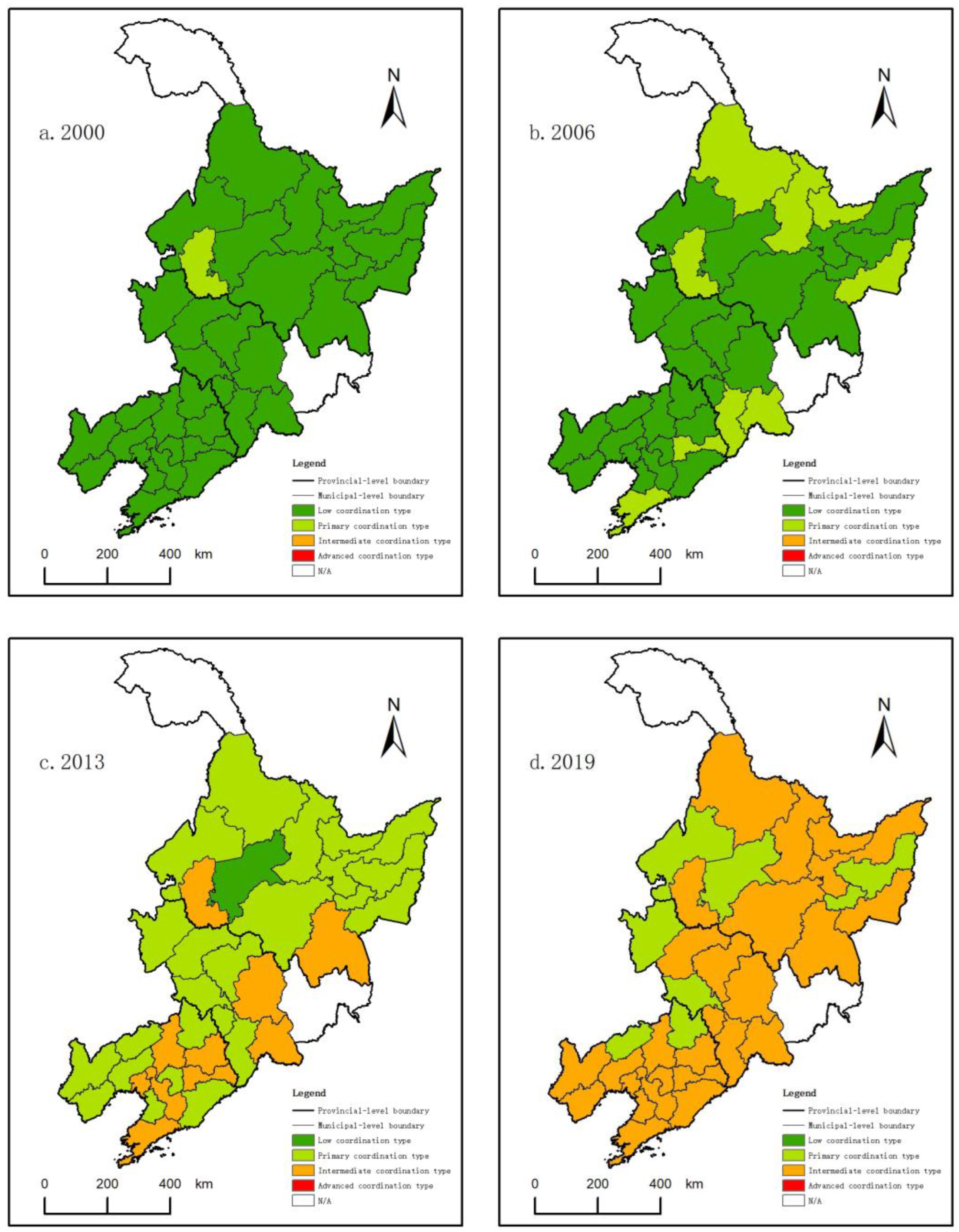
4.2. Spatial–Temporal Analysis of Urban–Rural Coupling and Coordination Degrees

By means of the measurement of coupling and coordination degrees of the overall urban and rural areas in various dimensions, an overall increase was noticed in the urban and rural coupling and coordination degrees of Northeast China during 2000–2019 (Figure 7). The urban–rural coupling coordination degree in Northeast China chiefly exhibited three types: Low coordination, primary coordination and intermediate coordination. The dominant type switched from low coordination to intermediate coordination, which is indicative of an overall growth in the degree of rural–urban coordination development in Northeast China. From the perspective of sub-dimensions, the coupling coordination degree of urban–rural economy and society appeared analogous to the other overall changes. The difference lies in the degree of urban–rural economic coupling coordination. The biggest growth was seen in the degree of urban–rural social coupling coordination, which suggests that urban and rural social development was given keen attention. A slight decline was found in the degree of urban–rural ecological coupling coordination, which implies that the concept of sustainable development and ecological priority was not efficiently supported in the urban and rural development, and in fact the ecological environment was sacrificed to a huge extent for the sake of economic and social development.
In this paper, we chose the urban–rural coupling coordination index of each city in 2000, 2006, 2013 and 2019, and based on Table 2, we adopted the method of natural breaking points to divide the urban–rural coupling coordination levels into five types (Figure 8). From 2000 to 2019, each type of newly added area transformed from adjacent coordination types, with less leapfrog growth and no backward development. The types of urban–rural coupling coordination degree in Northeast China grew from low and primary coordination to intermediate coordination. In 2000, all the cities in Northeast China enjoyed a balanced urban–rural coordination level; from the perspective of the spatial pattern, there was a downward trend from north to south, and a downward and then upward trend from east to west. Only the City of Daqing observed a faster development than the whole region and belonged to the primary coordination type. In 2006, there were nine cities belonging to the primary coordination type in urban–rural development, of which eight cities advanced from the low coordination type. The distribution of the cities under the primary coordination type presented the trend of border cities. In 2013, 76% of the cities in Northeast China fell under the primary coordination type, and only the city of Suihua belonged to the low coordination type, while the remaining cities were in the intermediate coordination type. The coupling coordination degree in the northeastern region was lower than that in the southern region; there was an inverted “U” trend from north to south, and a trend of “first decrease and then increase” from east to west. In 2019, there were eight cities under the primary coordination type, and 26 cities under the intermediate coordination type. Fifteen regions switched from the primary coordination type to the intermediate coordination type. A remarkable increase was witnessed in the level of coupling coordinated development, and the western region saw a relatively slower development. From 2000 to 2019, specific changes were found in the various types of coupling coordination (Table 3). There were nine cities under the slow-rising type, mainly distributed in the western region (Figure 9), nineteen cities under the stable-rising type and six cities under the leapfrog-rising type, primarily distributed along the Harbin–Dalian urban belt.

4.3. Diagnosis of Restrictive Factors for Urban–Rural Coupling Coordination in Northeast China

4.3.1. Restrictive Factors of Urban–Rural Coupling Coordination Degree

The restrictive degree model was adopted to measure the restrictiveness of each indicator towards the urban–rural coupling coordination. The top 10 indicators in restrictiveness from 2000 to 2019 were selected as the main restrictive factors (Table 4), and statistical analysis was carried out using the occurrence frequency for the main restrictive factors. It can be seen from the table that, first of all, X8, X9, X24, X27, X30, X31 and X32 were taken as the main restrictive factors from 2000 to 2019, which means that the restrictive factors for the coordinated development between urban and rural areas in Northeast China were relatively stable, and the restrictive factors in the urban and rural social dimensions and rural ecological environment dimensions played an instrumental role, including inadequate investment in urban fixed assets, the poor rural living environment in need of betterment and the limited number of rural cultural facilities. Secondly, X3 played a restrictive role in 2000–2007 and 2013–2019. With the change of time series, the restrictive effect of X5, X7 and X23 gradually reduced, while the restrictive effect of X4 and X6 surged after 2015. It is evident that the influence of per capita disposable income and the wages of urban residents were on the decline, while the influence of per capita total social fixed asset investment and per capita local fiscal revenue were on the rise, which implies that no remarkable progress has been made in the weak links of the urban and rural development of prefecture-level cities in Northeast China, but at the same time, a certain increase in the disposable income of urban and rural residents has curtailed the restrictive effect of these factors on the urban–rural coupling coordination degree.

4.3.2. Restrictive Layer of Urban–Rural Coupling Coordination Degree

We conducted the time series analysis of the restrictive factors at the target layer every year. The results (Table 5) illustrate that the rural social subsystem had the greatest degree of restrictiveness from 2000 to 2019, followed by the rural ecological environment subsystem. The difference between the two is that the former continued to decline, while the latter gradually increased. The urban economic and social subsystems also produced a strong influence, but the two exhibited a downward trend. The rural economic subsystem and the urban ecological subsystem generated a small influence, but the influence of the urban ecological subsystem was on the rise. Hence, to ensure the realization of coordinated development, it is vital to first emphasize the improvement of the social and ecological environment in rural areas. Subsequently, arrangements must be made to enhance the capability of urban economic and social development and shape the development framework as “urban areas boosting the development of rural areas”. At the same time, equal importance, if not more, must be given to the ecological environment protection of urban areas during course of development.

4.4. Discussions

The level of rural development is on the rise in urban and rural areas, and the rate of increase in the level of urban development is higher than that of rural development. This indicates that the new urbanization and rural revitalization strategy is not really beneficial in bettering the urban–rural relationship in Northeast China, and the phenomenon of weak urban and rural areas is found to be relatively common in Northeast China. Furthermore, it also suggests that the challenge of developing the rural areas of China is far greater than that of the urban areas, and rural revitalization has emerged as an uphill task. In the economic dimension, the development level of urban areas is always higher than that of rural areas, and the level of economic development in urban areas is much higher than that in rural areas. This implies that the urban economy is a major booster for the urban–rural relationship in Northeast China [52]. In the social dimension, both the urban and rural development exhibited an increasing trend, which proves that urban and rural social lives have been refined. In the ecological dimension, the urban ecological environment declined slightly, while the rural ecological environment showed a mild increase. Despite the occurrence of some minor variations in the ecological environment of the two systems, the range of that change appears relatively smaller. Compared with the other two dimensions, the ecological environment of the two systems needs to be strengthened and offers a huge room for improvement. The spatial distribution of urban and rural development in certain areas of Northeast China exhibits a dislocation phenomenon. For example, urban development is good, while rural development is poor. In the process of urban–rural integration development, the backward development level in rural areas is still the main obstacle to urban–rural development, especially the social and ecological system in rural areas. The Chinese government has proposed the rural revitalization policy which is making up for the shortcomings of high-quality coordinated urban–rural development [53].
According to the refined specialized division of labor and sustainable development, it is challenging to separate the urban–rural relationship when rural development is suppressed [3], and it is becoming impossible to achieve regional coordinated development. Therefore, the benign development of the urban–rural relationship in Northeast China emerges as instrumental in boosting regional development. The agricultural industry dominates the vital industrial distribution sector in Northeast China [54]. With vast plains and low hilly areas, Northeast China regions are endowed with superior natural resources and environment. The data published by the National Development and Reform Commission indicates that the grain output of Northeast China amounts for more than one fifth of the country’s grain output, making them a vital commodity grain base in China. Rural areas are essential carriers of grain production. The sound development of the urban–rural relationship tends to have a direct impact on China’s food security. The integration of population, economy, society, ecology and other factors between urban and rural areas can play a key role in endorsing urban development, and agricultural and rural development. Northeast China regions are surrounded by ecological barriers comprised of the Greater Khingan Mountains, Lesser Khingan Mountains and Changbai Mountains on three sides. With a robust ecological environment, they assume the function of China’s ecological security. The urban built-up areas and the areas of rural construction land are some of the major factors affecting the development of the ecological environment. The occupation of high-quality land in urbanized areas gives rise to the conflict between food security and ecological security. Northeast China regions possess strategically crucial geographic locations, and most of their border areas stand at the county level (county-level cities). The coordinated development of urban–rural relationship in areas positioned at the border areas can create a significant line of defense for border security. Northeast China regions are the old industrial bases with a prolonged development history and advanced technology in China. There exists a good foundation for a faster urbanization rate of Northeast China. With the support of large state-owned industrial enterprises, Northeast China regions have undergone the industrial “adjustment, transformation and reform” policy and striven for industrial revitalization. At this stage, they serve as China’s highly crucial comprehensive industrial base and act as key elements in boosting the high-quality development of urban and rural urbanization [55].
The coordinated development of the urban–rural relationship is not only beneficial for regional development, but also proves to be conducive to the balanced and adequate development of urban and rural areas. It can also assist in guiding the orderly and free movement of population, capital and technological factors between urban and rural areas [56], boost their integrated development and contribute to the new urbanization and rural revitalization strategies. Except for the four sub-provincial cities, Northeast China regions are characterized by widespread population shrinkage, and grave hollowing in the rural areas [57]. Large cities, large farms and large ecology are bound to become guiding factors for development in the future, and the development of the urban–rural relationship will become an important element of the development of Northeast China. According to the types of the coordinated urban–rural development categorized in this paper, differentiated and precise measures are adopted for different types and stages of urban–rural coordinated development: (1) To optimize the spatial structure of the coordinated development of large-, medium- and small-sized cities and towns, the integration of Harbin–Changchun city clusters and the central and southern Liaoning city clusters must be promoted, together with enhancing the energy level of the four core cities, and strengthening the construction of metropolitan circles centered around the four major cities. (2) To emphasize the rural development of Northeast China, especially the development of shrinking rural areas [58]. To adopt a smart shrinking strategy, limit the disorderly expansion of urban land for urban construction, increase the “link between people, land and funds”, guide the development of villages by classification, execute the pilot work of “the merger of villages and towns” in a robust manner, develop the farming system and protect the black soil. (3) To give importance to the protection and utilization of the ecological environment, create a solid barrier for ecological security in Northeast China and strive to balance ecological protection and high-quality development.
In this study, we analyzed the evolution process of urban and rural development in Northeast China considering several overall dimensions of urban and rural areas, and the urban–rural coordination relationship, thus enriching the research pool. With the help of existing statistical data, a multi-dimensional evaluation system for urban–rural coordinated development was established in economic, social and ecological dimensions to evaluate the evolution characteristics of urban–rural development, and the characteristics and types of urban–rural coordinated development in Northeast China. Through an analysis of the restrictive factors, it is possible to comprehensively analyze the factors affecting the urban–rural relationship in Northeast China. Due to the unavailability of certain data, this paper still bears some shortcomings. For example, the urban and rural ecological environment indicators need to be further advanced, and research must be performed in combination with urban and rural big data, survey data and other multi-source data. Based on existing urban and rural statistical data, no concrete influence mechanism exists that could facilitate the analysis of the coordinated development between the urban and rural areas in Northeast China from the perspective of balanced development between urban and rural areas.

5. Conclusions

After adopting the research on the relationship between the spatial–temporal evolution of urban and rural development level and restrictive factors as the main approach, we established the urban–rural coupling coordination indicator system. We employed the coupling coordination model to examine the spatial–temporal evolution characteristics of urban–rural integrated development in Northeast China. After the factors affecting urban–rural integrated development in Northeast China were chosen, we adopted the restrictive degree model to determine the significance of each factor and to analyze the action characteristics of the top 10 restrictive factors. The main conclusions drawn are as follows:
(1) From 2000 to 2019, the development of urban and rural areas in Northeast China exhibited a positive trend. There were larger localized differences in the development levels of urban and rural areas within the regions, and the development level of urban areas was higher than that of rural areas. With the passage of time, the economic and social development levels of both the urban and rural areas presented an increasing trend. The development level of ecological dimensions in the urban and rural areas lagged in their economic and social development levels. The ecological development level of urban areas first decreased and then increased, while the ecological development level of rural areas illustrated a trend of fluctuating decline. Attention should be paid to the quality of the rural ecological environment and measures should be proposed to strengthen ecological and environmental protection.
(2) From 2000 to 2019, the development level of the urban–rural integration in Northeast China constantly increased, and the type of coupling coordination degree switched from low and primary coordination to intermediate coordination. The higher-level urban–rural integration areas were the Harbin–Changchun city clusters and southern Liaoning city clusters, with a prominent agglomeration effect. At the same time, there were significant regional differences in the urban–rural integration development of Northeast China. The level of urban–rural integration in the northeast region is the spatial pattern of overall improvement, with central cities higher than peripheral cities.
(3) The analysis of the restrictive factors for urban–rural coordinated development at the urban–rural development indicator layers and subsystems in Northeast China suggests that the rural social subsystem has the highest degree of restrictiveness in urban–rural integration development. Of these factors, the restrictiveness of rural areas is higher than that of urban areas. The factors with higher restrictiveness in the coordinated development of urban and rural areas form the urban–rural social dimension indicators.
(4) The enhancement of the social factor function in rural areas can dynamically boost the integrated development of urban and rural areas. For example, increasing investment in urban and rural infrastructure construction and equalizing urban and rural public service facilities are some of the direct means to better the living standards of urban and rural residents in Northeast China. Based on the functions of Northeast China, combined with the evolution process of urban and rural development, together with the types of coordinated urban and rural development, the urban–rural integrated development mechanism should be established to strengthen the regional coordinated development of Northeast China by endorsing the high-quality development of the urban–rural relationship in Northeast China, which can improve people’s personal well-being and overall quality development.

Author Contributions

Conceptualization, Y.S. and Q.Y.; methodology, Y.S.; data curation, Y.S.; writing—original draft preparation, Y.S.; writing—review and editing, Y.S. and Q.Y.; visualization, Y.S.; supervision, Q.Y.; project administration, Q.Y.; funding acquisition, Q.Y. All authors have read and agreed to the published version of the manuscript.

Funding

This research was funded by Science and Technology Development Program Projects of Jilin Province, grant number 20190601001FG.

Institutional Review Board Statement

Not applicable.

Informed Consent Statement

Not applicable.

Data Availability Statement

Not applicable.

Acknowledgments

We greatly thank the reviewers and editors for their constructive suggestions and comments.

Conflicts of Interest

The authors declare no conflict of interest.

References

  1. Liu, Y. Research on the urban–rural integration and rural revitalization in the new era in China. Acta Geogr. Sin. 2018, 73, 637–650. [Google Scholar]
  2. Cui, S.; Zhou, G.; Dai, L.; Wu, G.; He, Y. Research Progress and Prospects of Urban–rural Integrated Development Based on Geographical Perspective. Econ. Geogr. 2022, 42, 104–113. [Google Scholar]
  3. Kurowska, K.; Kowalczyk, C. Rural Space Modeling-Contemporary Challenges. Land 2022, 11, 173. [Google Scholar] [CrossRef]
  4. Jie, F.; Hao, Z.; Rui, G. The New Trend and Coping Strategies of Regional Development Gap in China. Econ. Geogr. 2022, 42, 1–11. [Google Scholar]
  5. Lewis, A. Economic Development with Unlimited Supplies of Labour. Manch. Sch. Econ. Soc. Stud. 1954, 22, 139–191. [Google Scholar] [CrossRef]
  6. Guo, Y.; Tong, L.; Mei, L. The effect of industrial agglomeration on green development efficiency in Northeast China since the revitalization. J. Clean. Prod. 2020, 258, 120584. [Google Scholar] [CrossRef]
  7. Zanella, A.; Camanho, A.S.; Dias, T.G. The assessment of cities’ livability integrating human wellbeing and environmental impact. Ann. Oper. Res. 2015, 226, 695–726. [Google Scholar] [CrossRef]
  8. Xiu, C.; Xu, D.; Zhu, X. Evaluation of urban-Rural Integration Course in Northeast China. Sci. Geogr. Sin. 2004, 24, 320–325. [Google Scholar]
  9. Zhou, D.; Qi, J.; Zhong, W. Review of urban–rural integration evaluation: Connotation identification, theoretical analysis, and system reconstruction. J. Nat. Resour. 2021, 36, 2634–2651. [Google Scholar] [CrossRef]
  10. Zhao, M.; Fang, C.; Chen, C. Re-theorizing and Assessing Integrated Urban–rural Development: An Empirical Study on China’s Megacities. Urban Plan. Forum 2018, 242, 11–18. [Google Scholar] [CrossRef]
  11. Thomas, M. A Chinese Edition of Utopia; The Commercial Press: Beijing, China, 2006. [Google Scholar]
  12. Smith, A. A Chinese Edition of An Inquiry into the Nature and Causes of the Wealth of Nations; The Commercial Press: Beijing, China, 2002. [Google Scholar]
  13. Ye, C.; Chen, M. Review about the Theoretical Evolvement of Rural-ubran Relations. China Popul.·Resour. Environ. 2008, 18, 34–39. [Google Scholar]
  14. Marx, K.; Engels, F. A Chinese Edition of Manifesto of the Communist Party; The People’s Press: Beijing, China, 2014. [Google Scholar]
  15. Howard, E. A Chinese Edition of Garden Cities of Tomorrow; The Commercial Press: Beijing, China, 2010. [Google Scholar]
  16. Eliel, S. The City—Its Growth, Its Decay, Its Future; Reinhold: New York, NY, USA, 1943. [Google Scholar]
  17. McGee, T.G. Managing the rural—Urban transformation in East Asia in the 21st century. Sustain. Sci. 2008, 3, 155–167. [Google Scholar] [CrossRef]
  18. Lysgard, H.K. The assemblage of culture-led policies in small towns and rural communities. Geoforum 2019, 101, 10–17. [Google Scholar] [CrossRef]
  19. Liu, Y.; Lu, S.; Chen, Y. Spatio-temporal change of urban–rural equalized development patterns in China and its driving factors. J. Rural. Stud. 2013, 32, 320–330. [Google Scholar] [CrossRef]
  20. Kule, L. Urban-Rural Interactions in Latvian Changing Policy and Practice Context. Eur. Plan. Stud. 2014, 22, 758–774. [Google Scholar] [CrossRef]
  21. Sheykhi, M.T. Rural-urban balance as a measure of socio-economic development with special reference to Iran. J. Soc. Econ. Res. 2016, 3, 1–12. [Google Scholar] [CrossRef]
  22. Ovaska, U.; Vihinen, H.; Oostindie, H.; Farinos, J.; Hrabar, M.; Kilis, E.; Kobal, J.; Tisenkopfs, T.; Vulto, H. Network Governance Arrangements and Rural-Urban Synergy. Sustainability 2021, 13, 2952. [Google Scholar] [CrossRef]
  23. Rickardsson, J. The urban–rural divide in radical right populist support: The role of resident’s characteristics, urbanization trends and public service supply. Ann. Reg. Sci. 2021, 67, 211–242. [Google Scholar] [CrossRef]
  24. Zarifa, D.; Seward, B.; Milian, R.P. Location, location, location: Examining the rural-urban skills gap in Canada. J. Rural. Stud. 2019, 72, 252–263. [Google Scholar] [CrossRef]
  25. Boudet, F.; Macdonald, G.K.; Robinson, B.E.; Samberg, L.H. Rural-urban connectivity and agricultural land management across the Global South. Glob. Environ. Change-Hum. Policy Dimens. 2020, 60, 101982. [Google Scholar] [CrossRef]
  26. Baier, N.; Pieper, J.; Schweikart, J.; Busse, R.; Vogt, V. Capturing modelled and perceived spatial access to ambulatory health care services in rural and urban areas in Germany. Soc. Sci. Med. 2020, 265, 113328. [Google Scholar] [CrossRef]
  27. Seale, E. Coping Strategies of Urban and Rural Welfare Organisations and the Regulation of the Poor. New Political Econ. 2013, 18, 141–170. [Google Scholar] [CrossRef]
  28. Tacoli, C. The links between urban and rural development. Environ. Urban. 2003, 15, 3–12. [Google Scholar] [CrossRef] [Green Version]
  29. Berry, B.J.L.; Okulicz-Kozaryn, A. an urban-rural happiness gradient. Urban Geogr. 2011, 32, 871–883. [Google Scholar] [CrossRef]
  30. Van Sandt, A.; Carpenter, C.W. So Close, Yet So Far: The Benefits and Limits of Rural-Urban Industry Linkages. Sustainability 2022, 14, 2875. [Google Scholar] [CrossRef]
  31. Shucksmith, M.; Cameron, S.; Merridew, T.; Pichler, F. Urban-Rural Differences in Quality of Life across the European Union. Reg. Stud. 2009, 43, 1275–1289. [Google Scholar] [CrossRef]
  32. Chen, M.X.; Zhou, Y.; Huang, X.R.; Ye, C. The Integration of New-Type Urbanization and Rural Revitalization Strategies in China: Origin, Reality and Future Trends. Land 2021, 10, 207. [Google Scholar] [CrossRef]
  33. Chen, K.; Long, H.; Liao, L.; Tu, S.; Li, T. Land use transitions and urban–rural integrated development: Theoretical framework and China’s evidence. Land Use Policy 2020, 92, 104465. [Google Scholar] [CrossRef]
  34. Chen, C.; Legates, R.; Zhao, M.; Fang, C. The changing rural-urban divide in China’s megacities. Cities 2018, 81, 81–90. [Google Scholar] [CrossRef]
  35. Gao, L.; Yan, J.; Du, Y. Identifying the Turning Point of the Urban-Rural Relationship: Evidence from Macro Data. China World Econ. 2018, 26, 106–126. [Google Scholar] [CrossRef]
  36. Liu, C.; Zhang, Z. From Town-country Integration to Urban–rural Integration: New Thinking on the Relationship Between Urban and Rural Areas. Sci. Geogr. Sin. 2018, 38, 1624–1633. [Google Scholar]
  37. Dai, H.; Sun, T.; Zhang, K.; Guo, W. Research on Rural Nonpoint Source Pollution in the Process of Urban-Rural Integration in the Economically-Developed Area in China Based on the Improved STIRPAT Model. Sustainability 2015, 7, 782–793. [Google Scholar] [CrossRef] [Green Version]
  38. Ge, D.; Long, H. Rural spatial governance and urban–rural integration development. Acta Geogr. Sin. 2020, 75, 1272–1286. [Google Scholar]
  39. Du, G.; Liu, M. A factor-based theoretical analysis of urban–rural relationship change. Prog. Geogr. 2021, 40, 1298–1309. [Google Scholar] [CrossRef]
  40. Zhou, J.; Qin, F.; Liu, J.; Zhu, G.; Zou, W. Measurement, spatial-temporal evolution and influencing mechanism of urban–rural integration level in China from a multidimensional perspective. China Popul. Resour. Environ. 2019, 29, 166–176. [Google Scholar]
  41. Zhang, H.; He, R.; Li, G.; Wang, J. Spatiotemporal Evolution of Coupling Coordination Degree of Urban-Rural Integration System in Metropolitan Area and Its Influencing Factors: Taking the Capital Region as an Example. Econ. Geogr. 2020, 40, 56–67. [Google Scholar]
  42. Xin, W.; Peng, C. A Study of the Time–Space Evolution Characteristics of Urban–Rural Integration Development in a Mountainous Area Based on ESDA-GIS: The Case of the Qinling-Daba Mountains in China. Sustainability 2016, 8, 1085. [Google Scholar]
  43. Zhang, X.; Qiu, F.; Zhu, C. Evolution of urban–rural integration in Huaihai Economic Zone from the perspective of spatio-temporal interaction. J. Nat. Resour. 2020, 35, 1867–1880. [Google Scholar]
  44. Du, B.; Wang, Y.; He, J.; Li, W.; Chen, X. Spatio-Temporal Characteristics and Obstacle Factors of the Urban-Rural Integration of China’s Shrinking Cities in the Context of Sustainable Development. Sustainability 2021, 13, 4203. [Google Scholar] [CrossRef]
  45. Li, Y. Urban–rural interaction patterns and dynamic land use: Implications for urban–rural integration in China. Reg. Environ. Chang. 2012, 12, 803–812. [Google Scholar] [CrossRef]
  46. Liu, Y.; Chen, C.; Li, Y. Differentiation regularity of urban–rural equalized development at prefecture-level city in China. J. Geogr. Sci. 2015, 25, 1075–1088. [Google Scholar] [CrossRef]
  47. He, Y.; Zhou, G.; Tang, C.; Fan, S.; Guo, X. The spatial organization pattern of urban–rural integration in urban agglomerations in China: An agglomeration-diffusion analysis of the population and firms. Habitat Int. 2019, 87, 54–65. [Google Scholar] [CrossRef]
  48. Liu, Y.; Long, H.; Li, Y. Human geography research based on the new thinking of global rural-urban relationship. Acta Geogr. Sin. 2021, 76, 2869–2884. [Google Scholar]
  49. Fang, C. Theoretical analysis on the mechanism and evolution law of urban–rural integration development. Acta Geogr. Sin. 2022, 77, 759–776. [Google Scholar]
  50. Liu, J.; Yang, Q.; Jiang, X.; Liu, J. Relationship Type and Regional Pattern Between Grain Production and Economic Development in Northeast China. Econ. Geogr. 2021, 41, 39–48, 57. [Google Scholar]
  51. Ma, L.; Long, H.; Ge, D.; Zhang, Y.; Tu, S. Research on the Ways of Urban-Rural Coordinated Development and Rural Vitalization in the Farming Areas of China. Econ. Geogr. 2018, 38, 37–44. [Google Scholar]
  52. Huang, Y. Spatial Pattern of Urban–rural Coordination Development in Northeast China. Sci. Geogr. Sin. 2019, 39, 1302–1311. [Google Scholar]
  53. Wang, Y.; Chen, X.; Sun, P.; Liu, H.; He, J. Spatial-temporal Evolution of the Urban–rural Coordination Relationship in Northeast China in 1990–2018. Chin. Geogr. Sci. 2021, 31, 429–443. [Google Scholar] [CrossRef]
  54. Lazzarini, L. The role of planning in shaping better urban–rural relationships in Bristol City Region. Land Use Policy 2018, 71, 311–319. [Google Scholar] [CrossRef]
  55. Wang, S.; Ma, L. Strategic Thinking of Northeast China Revitalization During the 14th Five-Year Plan Based on the Macro Situation and Regional Advantages. Sci. Geogr. Sin. 2021, 41, 1935–1946. [Google Scholar]
  56. Mainet, H. Town dwellers in their networks: Urban–rural mobility and household strategies in Cameroon. Geogr. Tidsskr.-Dan. J. Geogr. 2017, 117, 117–129. [Google Scholar] [CrossRef]
  57. Ma, Z.; Li, C.; Zhang, J. Understanding Urban Shrinkage from a Regional Perspective: Case Study of Northeast China. J. Urban Plan. Dev. 2020, 146, 05020025. [Google Scholar] [CrossRef]
  58. Smith, G.; Archer, R.; Nandwani, D.; Li, J. Impacts of urbanization: Diversity and the symbiotic relationships of rural, urban, and spaces in-between. Int. J. Sustain. Dev. World Ecol. 2018, 25, 276–289. [Google Scholar] [CrossRef]
Figure 1. Theoretical Framework Diagram.
Land 11 01195 g001
Figure 2. Overview of the Research Region.
Land 11 01195 g002
Figure 3. Changes in the Development Levels of Urban and Rural Areas in the Three Northeastern Provinces of China.
Land 11 01195 g003
Figure 4. Changes in Various Dimensions of Development Levels of Urban and Rural Areas in the Three Northeastern Provinces. (a) Urban; (b) Rural.
Land 11 01195 g004
Figure 5. Spatial Distribution of Urban Development Levels in Northeast China. (a) 2000; (b) 2006; (c) 2013; (d) 2019.
Land 11 01195 g005
Figure 6. Spatial Distribution of Rural Development Levels in Northeast China. (a) 2000; (b) 2006; (c) 2013; (d) 2019.
Land 11 01195 g006
Figure 7. Urban–rural Coupling and Coordinated Development of Northeast China and the Changes of Various Dimensions.
Land 11 01195 g007
Figure 8. Spatial Distribution of Urban–rural Coupling and Coordinated Development Levels in Northeast China. (a) 2000; (b) 2006; (c) 2013; (d) 2019.
Land 11 01195 g008
Figure 9. Distribution of Changes of Urban–rural Coupling Coordination Degree Types in Northeast China.
Land 11 01195 g009
Table 1. Evaluation Index System of the Development Level of Urban–rural Integration in Northeast China.
SystemDimensionIndicatorWeight (w)SystemDimensionIndicatorWeight (w)
UrbanEconomyPer capita output value of secondary and tertiary industries (X1)/yuan (RMB)0.060RuralEconomyPer capita agricultural output value (X17)/yuan (RMB)0.004
Proportion of secondary and tertiary industry output value (X2)/(%)0.030Labor productivity of primary industry (X18)/yuan/person (RMB)0.007
Labor productivity of secondary and tertiary industries (X3)/yuan/person (RMB)0.099Proportion of primary industry output value (X19)/%0.004
Total social fixed asset investment per capita (X4)/yuan (RMB)0.080Total social fixed asset investment per capita (X20)/yuan (RMB)0.044
Average wage (X5)/yuan (RMB)0.107Average wage (X21)/yuan (RMB)0.011
Per capita local fiscal revenue (X6)/yuan (RMB)0.069Grain output per mu (X22)/ton0.057
SocietyPer capita disposable income (X7)/yuan (RMB)0.112SocietyPer capita disposable income (X23)/yuan (RMB)0.123
Per capita consumption expenditure (X8)/yuan (RMB)0.099Per capita consumption expenditure (X24)/yuan (RMB)0.078
Public budget expenditure per capita (X9)/yuan (RMB)0.096Public budget expenditure per capita (X25)/yuan (RMB)0.043
Total teachers and students in primary and secondary schools per 1000 people (X10)/person0.016Total teachers and students in primary and secondary schools per 1000 people (X26)/person0.038
Books collected in public libraries per 1000 people (X11)/book0.043Books collected in public libraries per 1000 people (X27)/book0.082
Number of beds in hospitals and health centers per 1000 people (X12)/bed0.029Number of beds in hospitals and health centers per 1000 people (X28)/bed0.053
EcologyGreen area per capita (X13)/m20.011EcologyAverage fertilizer consumption per hectare (X29)/ton/hm20.090
Green coverage rate of built-up area (X14)/%0.023Forest coverage rate (X30)/%0.160
PM2.5 (X15)/um0.066Proportion of grassland area (X31)/%0.095
Proportion of built-up area (X16)/%0.059Proportion of water area (X32)/%0.109
Table 2. The Coupling Coordination State Division Standards for the Urban–rural Integration System in Northeast China.
Coupling Coordination DegreeCoupling Coordination TypeCharacteristics
0 ≤ D ≤ 0.2Severe imbalance type (I)Mutual restriction and disorderly development of urban and rural systems
0.2 < D ≤ 0.35Mild imbalance type (II)The decreasing degree of inhibition between the urban and rural systems.
0.35 < D ≤0.5Low coordination type (III)Basically, no inhibitory effect exists between the urban and rural systems.
0.5 < D ≤0.6Primary coordination type (IV)A positive promotion effect is primarily achieved between the urban and rural systems.
0.6 < D ≤0.8Intermediate coordination type (V)Mutual promotion between urban and rural systems and the orderly development of urban and rural areas is achieved.
0.8 < D ≤1.0Advanced coordination type (VI)Free movement of factors between the urban and rural systems; thereby, the integrated development of urban and rural areas is achieved.
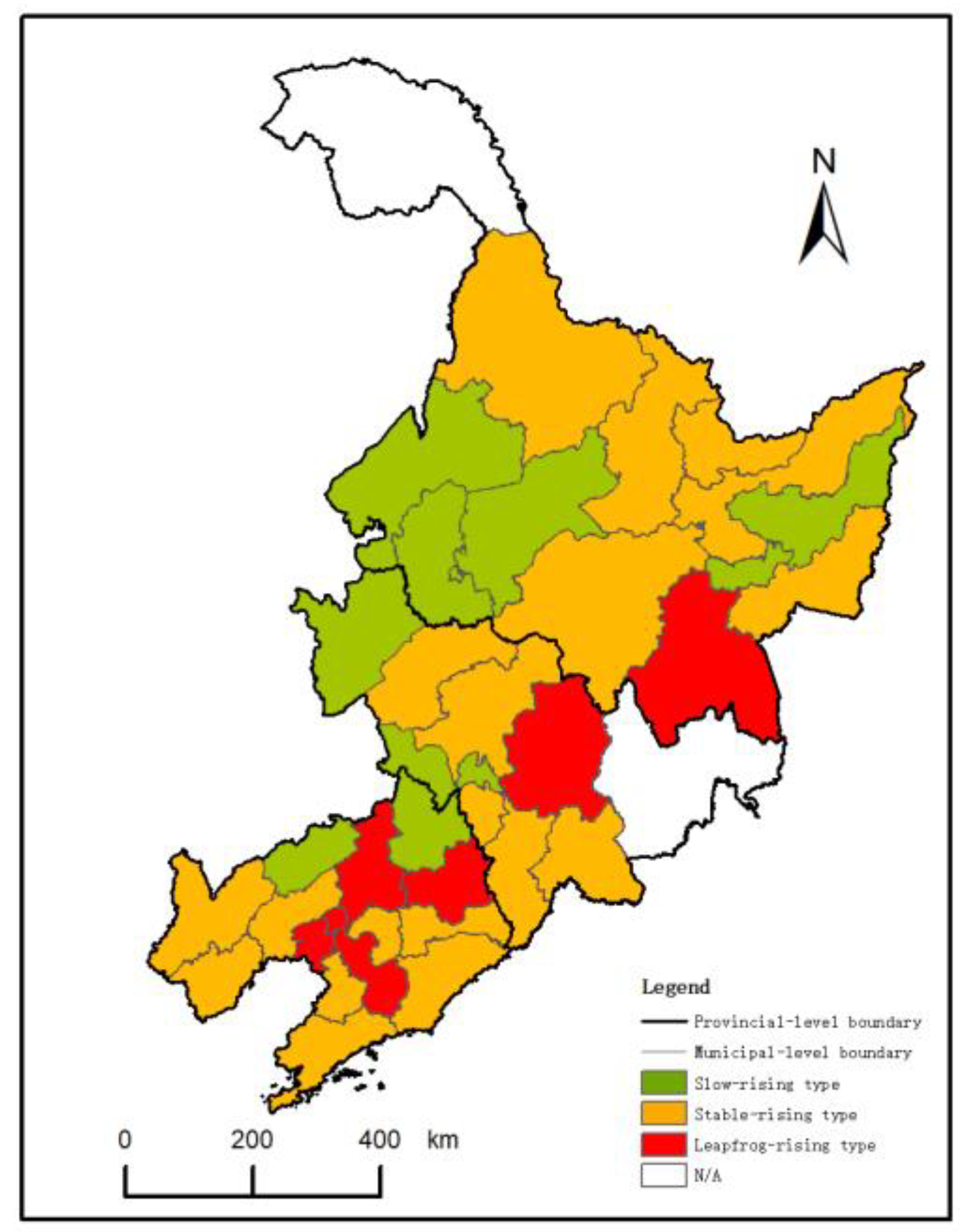
Table 3. Changes in the Coupling Coordination Types.
Type of ChangeChanging Trend of Coupling Coordination TypesCity
Slow-rising typeIII→III→III→IVSuihua
III→III→Ⅳ→IVFuxin, Tieling, Siping, Baicheng, Qiqihar, Shuangyashan and Qitaihe
Ⅳ→IV→V→VDaqing
Stable-rising typeIII→III→IV→VDandong, Jinzhou, Yingkou, Liaoyang, Chaoyang, Huludao, Changchun, Liaoyuan, Songyuan, Harbin and Jiamusi
III→IV→IV→VTonghua, Jixi, Hegang, Yichun and Heihe
III→IV→V→VDalian, Benxi and Baishan City
Leapfrog-rising typeIII→III→V→VShenyang, Anshan, Fushun, Panjin, Jilin and Mudanjiang
Table 4. Restrictive Indicators of Urban–rural Integration and their Restrictive Degree in Northeast China.
YearX3X4X5X6X7X8X9X23X24X27X30X31X32
20000.1000 0.1000 0.1000 0.1000 0.1000 0.1000 0.0824 0.0706 0.0794 0.0735
20010.1000 0.1000 0.1000 0.1000 0.1000 0.1000 0.0824 0.0676 0.0676 0.0794 0.0765
20020.1000 0.1000 0.1000 0.1000 0.1000 0.1000 0.0794 0.0706 0.0706 0.0794 0.0794
20030.1000 0.1000 0.1000 0.1000 0.1000 0.1000 0.0824 0.0735 0.0794 0.0794
20040.0941 0.1000 0.1000 0.1000 0.1000 0.1000 0.0824 0.0706 0.0706 0.0794 0.0824
20050.0912 0.1000 0.1000 0.1000 0.1000 0.1000 0.0765 0.0706 0.0794 0.0824
20060.0912 0.1000 0.1000 0.1000 0.0941 0.1000 0.0794 0.0706 0.0706 0.0794 0.0853
20070.0765 0.1000 0.1000 0.1000 0.0941 0.1000 0.0824 0.0765 0.0794 0.0853
2008 0.1000 0.1000 0.0971 0.0912 0.1000 0.0824 0.0824 0.0735 0.0824 0.0853
2009 0.1000 0.1000 0.0971 0.0765 0.1000 0.0853 0.0824 0.0765 0.0853 0.0882
2010 0.1000 0.1000 0.0941 0.0824 0.1000 0.0824 0.0853 0.0765 0.0853 0.0882
2011 0.1000 0.0941 0.0853 0.0735 0.0971 0.0824 0.0824 0.0765 0.0882 0.0882
2012 0.0941 0.0853 0.0853 0.0647 0.0912 0.0794 0.0853 0.0765 0.0882 0.0882
20130.0794 0.0853 0.0765 0.0647 0.0706 0.0735 0.0794 0.0794 0.0941 0.0941
20140.0824 0.0794 0.0794 0.0647 0.0765 0.0618 0.0706 0.0794 0.0941 0.0941
20150.0765 0.0735 0.0676 0.0794 0.0676 0.0647 0.0706 0.0794 0.0941 0.0912
20160.0824 0.0853 0.0588 0.0529 0.0794 0.0647 0.0529 0.0794 0.0794 0.0941 0.0912
20170.0765 0.0824 0.0559 0.0794 0.0647 0.0588 0.0971 0.0794 0.0971 0.0912
20180.0647 0.0824 0.0676 0.0824 0.0706 0.0618 0.0971 0.0794 0.1000 0.0971
20190.0765 0.0882 0.0706 0.0824 0.0529 0.0559 0.0971 0.0794 0.1000 0.0971
Table 5. Restrictive Degree of Urban–rural Integration Subsystem in Northeast China.
YearUrban–EconomicUrban–SocialUrban–EcologicalRural–EconomicRural–Social 2Rural–Ecological
20000.240 0.217 0.042 0.079 0.238 0.185
20010.238 0.216 0.043 0.079 0.237 0.187
20020.237 0.219 0.043 0.079 0.233 0.189
20030.235 0.213 0.046 0.079 0.240 0.188
20040.234 0.213 0.044 0.077 0.239 0.192
20050.233 0.212 0.045 0.077 0.238 0.195
20060.230 0.210 0.049 0.077 0.237 0.197
20070.225 0.208 0.049 0.078 0.238 0.202
20080.219 0.206 0.054 0.077 0.238 0.206
20090.217 0.204 0.050 0.079 0.237 0.213
20100.212 0.203 0.050 0.079 0.236 0.221
20110.207 0.197 0.057 0.079 0.231 0.228
20120.204 0.193 0.058 0.079 0.230 0.237
20130.203 0.187 0.059 0.079 0.221 0.249
20140.206 0.181 0.066 0.081 0.219 0.247
20150.212 0.179 0.066 0.083 0.213 0.248
20160.218 0.181 0.057 0.085 0.206 0.252
20170.210 0.182 0.057 0.086 0.214 0.252
20180.204 0.177 0.051 0.089 0.214 0.265
20190.211 0.177 0.052 0.087 0.204 0.268
mean value0.220 0.199 0.052 0.080 0.228 0.221
Publisher’s Note: MDPI stays neutral with regard to jurisdictional claims in published maps and institutional affiliations.

