Abstract
In recent decades in the Mediterranean basin there has been a considerable increase in both the number of wildfires and the extent of fire-damaged areas, resulting in ecological and socio-economic impacts. Protected areas are particularly vulnerable and many characteristics underpinning their legal protection are threatened. Several studies have been devoted to mitigating wildfire risks inside the protected areas, however often only in regard to natural heritage losses. Based on the adaptive wildfire resilience approaches, this work proposes a framework of actions that integrates natural, social and economic components. Starting from the Vesuvius National Park case study, affected by wildfires in 2017, the paper proposes a framework of action, envisaging two main phases: (i) the identification of priority intervention areas, by means of spatial multicriteria decision analysis, and (ii) damage assessment by using a monetary approach to value ecosystem services (ESs). The results identified priority areas where to concentrate economic and material resources, and estimated ecosystems damage, demonstrated ESs losses in areas adjacent to the burnt ones. This work, by integrating the relation between environmental sciences and policy, underpins a medium-long term development planning process. The aim of this work is to support landscape management and planning that includes socio-economic components such as sustainable development measures.
1. Introduction
Wildfires have been one of the primary forces shaping Mediterranean ecosystems and landscapes, and recurrent fire disturbances shape vegetation patterns and processes and their resilience over time [1]. Although wildfires are perceived as catastrophic disturbances by the public [2], in most ecosystems they have been recognized as an important natural process [3,4]. Wildfires’ disturbance patterns exert strong selective pressure on the life-history strategies of various plant species, affecting the survival and spread of some plant communities [5], and may, in turn, provide a variety of benefits to humankind, e.g., pasture management [6]. In recent decades in the Mediterranean basin there has been a considerable increase both in the number of wildfires and the extent of fire-damaged areas, resulting in increased ecological and socio-economic impacts. Fire damage has therefore attracted the attention of many scholars, with studies focusing on various aspects of wildfires, such as their possible causes (e.g., human-made, natural) exacerbated by global warming and extreme weather events [7,8,9], GIS based vulnerability assessment [10,11], propagation models [12,13], effects on ecosystems and damage quantification [14,15,16], and prevention measures [17,18,19,20].
Protected areas (PA) are recognized as a strategic focus in wildfire management, both in terms of resource protection (i.e., habitat and species conservation, ecosystems services production, local livelihoods and national development support, recreation and social benefits and the economic value associated) [21,22] and in terms of vulnerability, because of the presence of unmanaged vegetation, potentially susceptible to ignition and easy propagation of fires [23,24]. These areas are strategic in landscape management, specifically because, as defined by the IUCN, they are devoted to the protection and maintenance of biological diversity [25,26]. Despite this, as reported by San-Miguel-Ayanz et al. (2017) [27], between the years 2000 and 2012, about 80,000 ha per year of Natura 2000 sites have burned. Furthermore, during the year 2017, wildfires affected protected areas from many countries of the Mediterranean basin; Portugal, Spain, and Italy were the most affected ones [11]. The traditional fire suppression and ignition prevention measures proved themselves to be insufficient [28].
PA ordinary management and planning are complex processes due to the time and spatial scales involved, as well as the diversity and interconnection of effects and the number of stakeholders involved [29]. According to the forest landscape restoration approach, promoted by the IUCN and WWF International [30], integrated approaches must be implement [31,32,33] considering the ecological processes at the landscape level as a whole. Among the landscape planning methodologies, the MultiCriteria Analysis (MCA) is considered to be an appropriate approach to examine the impact of different policy options relevant for natural resources and environmental management [34,35,36]. Specifically, the spatial multicriteria decision analysis (S-MCDA) [37], can be significantly supportive due to: (i) integrating geographic information systems (GIS) and multicriteria decision analysis; (ii) handling large amounts of complex geo-referred data that is derived from different sources and elaborated at multi-spatial, multi-temporal and multi-scale levels; (iii) linking driving forces with pressure and effects on the landscape; (iv) facilitating communication between decision-makers and stakeholders, including value judgments, preferences and uncertainties; and (v) allowing an overall assessment for choosing among alternative actions, hypotheses and localizations [37,38]. The ability to link driving forces with pressure and impacts on the landscape and to facilitate communication between decision-makers and stakeholders makes the S-MCDA a useful tool for wildfire management as well.
In these contexts, the landscape planning and management approaches, based on the holistic criterion, can significantly contribute to the scientific and operational debate on wildfires, both in terms of prevention and landscape restoration, via ex ante analysis, damage assessment, risk assessment, scenario building, monitoring and decision support systems [39]. Although aspects connected with modelling or assessment of fire risk and vulnerability, principally devoted to forest types, have been extensively investigated [40,41], their implementation into a general conceptual framework, considering all the social, economic and environmental components, is quite recent [30,31,42] and needs to be implemented and validated. The awareness that landscape management, starting from land-use/cover changes, has direct implications on fire risk [43], not only in terms of land composition (e.g., the abandonment of agricultural lands or afforestation activities), but also in terms of configuration (creation of new interface areas between urban and natural/agricultural ones), leads resource managers to consider a new approach for fire management, extended to landscape planning [44], as introduced by the concept of adaptive and transformative resilience [28,45,46]. Within the categories of adaptive resilience, the present work focuses attention on the social perspective (landscape planning), rather than on an ecological perspective (specific interventions on ecosystems and natural habitats burned).
In line with their potential, landscape planning approaches are moving towards decision-making support processes which explicitly highlight the importance of integrating nature’s contribution to people’s wellbeing [47] through the ecosystem services theory (ES). An explicit valuation of ESs helps to not only quantify the effects on the landscape of a specific cause, it also suggests the possible consequences of different intervention scenarios on the environment itself [48,49]. The value of ecosystems and their services is generally expressed in different ways: biophysical, socio-cultural and economic [50,51,52,53]. ESs valuation in economic terms is certainly the most commonly used and discussed [51,54,55,56].
Based on the literature, the present work, rather than proposing new ES assessment methods or multicriteria analysis processes, aims to implement the ES assessment into an action framework. The framework considers scholars’ expertise and perspectives, working phases and approaches, and the conditions of the Mediterranean basin. As a matter of fact, many of the European protected areas are facing strong human pressure [57,58,59]. For these contexts, integrated landscape management typical of the land-planning approaches helps to ensure a balance among nature conservation, the socio-economic needs of the population, and the touristic and scientific use of the area [60].
Given the aforementioned need to integrate different approaches, the present work is based on the driving forces-pressures-state-impacts-responses (DPSIR) model [61,62,63], integrated with the spatial-multicriteria decision analysis and ecosystem services approaches. The DPSIR is a theoretical approach widely used for investigating environmental problems by establishing cause-effect relationships between anthropogenic activities and their environmental and socio-economic consequences [64]. The DPSIR model is used in landscape and land-use planning not only in the management of the ordinary lands, but also for the protected natural areas thanks to its flexibility and integrability [65,66,67].
In the present work, the management of protected natural areas in relation to fire risk is considered as a landscape system, which can be evaluated through a combination of ecological factors linked to the physical asset of the territory and the social conditions of the population in the area. The work is based on the case study of the Vesuvius National Park (Southern Italy), where multiple wildfires occurred in the summer of 2017 that burned 3350 ha of forest and shrubland [68,69]. The study area is traditionally subject to summer fires, generally of modest size (Italian National Geoportal), from 4 to 140 ha/y in the last twenty years. The extent and severity of the 2017 fires caused a notable alteration in the risk of forest fires for the coming summer seasons. It is estimated that the extensive mortality of conifer reforestation, the necromass accumulated on the ground, the opening of the foliage in the broad-leaved woods and the development of herbaceous and shrubby vegetation, in the next decade, may lead to a progressive increase in fuel [68]. This condition, in the absence of appropriate management, could contribute to increasing the ignition of new fires capable of spreading over large surfaces.
The aim of the work is to test the suggested framework of action, in the immediate post-fire management phase, within Mediterranean protected areas, in order to:
- take into account the different context components, different objectives and different stakeholders “points of view”;
- make the decision-making process more transparent and, thus the decisions more sharable;
- make timely and rapid responses, considering both biotic and abiotic component requirements.
In the first part of the paper, priority intervention areas (PIAs) were identified to verify the predictable effects derived from the planned interventions. The priority intervention areas neither coincide with the park priority management areas or other institutional and literature classification types [70,71,72,73,74], nor with the areas of first intervention during the wildfire. Their identification is more linked to the adaptive resilience approach applied to identify which areas to concentrate the immediate post-fire recovery and remediation activities. The identification of the PIAs is processed not only according to the wildfire’s severity but also to the role that those areas play in terms of (i) safety from hydrogeological instability; (ii) renewal of processes for the biodiversity support; (iii) recovery of anthropic activities (fruition or production); and (iv) restoration of the landscape image and of its sense of identity. In this paper the identification of PIAs arises from the need to plan specific interventions and to distribute economic resources for strategic areas within the park.
In the second part, damage assessment was carried out via ES valuation to support the design of interventions in landscape planning and management, and was merged with bio-physical parameters in order to compare different time steps and different action scenarios. GIS-based models were then adopted, obtaining the spatial distribution of ES in pre- and post-wildfires phases.
The methodological approach used to integrate specific post-fire restoration measures aims to become as a useful tool for the management of different environmental risks inside the protected areas, implementing proactive risk management and helping to recognize the complexity of physical and socio-economic dynamics which characterize all landscape systems.
2. Materials and Methods
2.1. Study Area
Vesuvius National Park (International Union for Conservation of Nature—IUCN—Category II—National Park, 40°49′15.05″ N; 14°25′35.85″ E) was established in 1995 to preserve an area of outstanding natural and socio-cultural importance. It includes “animal and plant species, plant and forest associations, geological singularities, paleontological formations, biological communities, biotopes, scenic and panoramic values, natural processes, hydraulic and hydrogeological balances, ecological balances of the Vesuvian territory”. It covers (Figure 1) about 8250 ha (from 44 m to 1275 m a.s.l.), comprising one National Reserve, two sites of community importance and one special protection area. The area includes the only volcanic complex, namely Somma-Vesuvius, which is still active in mainland Europe [75]. The area is characterized by a mosaic of land covers/uses, with 54% of the area in natural and semi-natural areas, 38% farmland, and the remaining 8% in man-made structures and infrastructures. Overall, the forest areas account for about 3800 ha (~46% of the total park area), consisting of pure and mixed broadleaved stands, even-aged monospecific and mixed coniferous stands and shrubland. Some coniferous stands are currently listed as sites of community importance for Habitat 9540—Mediterranean pine forests with endemic Mesogean pines [69,76]. The area has major tourism potential due to the singularity of the volcano and lava-field geo-sites and the natural landscape and trails, as well as its cultural heritage, the Eighteen-century historical buildings, and its profound connection with the neighboring archaeological sites of Pompeii, Herculaneum and Oplontis. The protected area of Vesuvius National Park is surrounded by a densely populated conurbation around the foothills of Vesuvius: 350,000 inhabitants (2017 Census data) live in urban areas located at the park boundaries, but the neighboring metropolitan area of Naples includes about three million inhabitants. This area is also known for its typical agricultural products such as wine, apricots, tomatoes, and cherries (with different quality certifications), and floriculture.
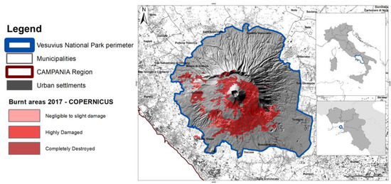
Figure 1.
The study area: Vesuvius National Park in Campania (Italy). Non English contents are place names.
In the summer of 2017, from 5 July to 27 August, 24 wildfires affected the national park, and 3350 ha (the 38% of the park) were totally or partially destroyed. Figure 1 shows the entirety of the areas covered by fire. The map titled “Vesuvius” [EMSR213_01VESUVIO], was taken from the Copernicus database (available at emergency.copernicus.eu) and it is updated to 19 July 2017. The map was obtained from the processing of Sentinel 2A and Sentinel 2B satellite images acquired by ESA during the summer of 2017 using an automatic algorithm [77] and the fuzzy integration of spectral indices (e.g., combinations of the spectral bands of the S2 sensor).
The map shows that the urban and agricultural areas were not directly affected by the wildfires; instead, forests and semi-natural habitat significantly burned, with the Habitat 9540—Mediterranean pine forests with endemic Mesogean pines, the most affected forest class. Immediate post-fire management was aimed at controlling the erosion rate and forest habitat restoration. On the basis of direct field surveys and research studies developed by the park authority in conjunction with University of Naples Federico II, the restoration of forest cover was initiated, and native Mediterranean tree and shrub species were planted.
2.2. Steps in Method
The DPSIR framework is a comprehensive model for structuring such complex information. It allows linking different concepts, methods and indicators useful in decision making, from system analysis to ecosystem services assessment and design of scenarios. Figure 2 highlights, with different colours, the three approaches used and their interactions, in terms of steps in the method and results contributions.
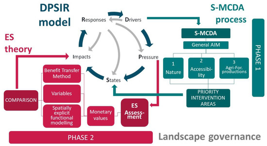
Figure 2.
The framework of action.
In the DPSIR model, the “driving forces” are the socio-economic and socio-cultural variables which pose “direct pressure” on the environment. “State/-s” is/are given by the specific structural conditions of both natural and socio-economic systems. The “impacts” are the socio-economic and ecologic effects that resulted from the changes of the ecosystem characteristics. “Responses” are the efforts and strategies set by the policymakers and civil society to reduce negative effects [78]. These responses may influence/reduce negative drivers or pressures, safeguarding or enhancing the state/-s, or mitigating effects [79], as indicated by the direction of the light grey arrows in Figure 2.
The work is based on the DPSIR model process which identifies the social and economic driving forces using a holistic approach, and characterizes landscape and targets to specific planning aims. The criteria-dynamics analysis on the study area allowed for the deepening of the pressures of driving forces on ecosystems, highlighting strengths and weaknesses of the landscape system. Introducing the time as a parameter, it was then possible to compare different system states, assuming trends or future alternatives.
Two steps of the DPSIR model were developed with support of two different approaches:
- Development of the “states” using the S-MCDA methodology to identify PIAs.
- The “impact” analysis, including the assessment of wildfires damage, through the ecosystem services approach.
These two steps are explained in the next two sections.
2.3. Identification of Priority Intervention Areas via Spatial-Multicriteria Decision Analysis
S-MCDA based on a hierarchical structure of criteria was preferred because it addresses the decision process in detail and deals with a limited and clearly defined set of alternatives [80]. In the last decades, group decision-making approaches, based on multiple experts, have been widely used in several fields: economics, engineering, landscape planning, and biology. Specifically, these approaches, developed to handle experts’ judgments and opinions, can be articulated into subjective or objective methods [81]. The first ones are based on the need to involve the subjective importance of criteria expressed by the experts or decision-makers; the last ones are characterized, instead, by the objective importance of criteria, which can be determined according to the decision matrix, which is based on the judgments of the experts, on the objective evaluation of alternatives, or on a combination of them [81]. The choice of the method to use for handling experts’ opinions is a crucial issue in the multicriteria decision analysis process. In the present paper a subject method was chosen which, although it increases the uncertainty of the evaluation system, is widely used in other studies concerning the “identification of priority areas” topic [27,81,82,83], and it allows the rapid identification of the intervention’s measures. A panel of eight experts, consisting of agronomists, forestry experts, land-use planners, modelling experts and hydraulic engineers, supported the different phases in the S-MCDA process. The expert judgment was obtained via an iterative process which entailed the following steps. Firstly, a form containing the aims statement, the description of the tree’s structure and the criteria selection was shared with all panellists, who met over several sessions of interactive workshops to discuss the following points: (i) the identification of three essential components of the general object of the Park; (ii) the establishment of a hierarchy tree structure and criteria; (iii) the standardization and weighting processes; and (iv) the discussion of resulting suitability maps. Unanimous agreement was achieved on each point after a participatory process by the panel of experts. The activities done are described more in detail in the following sections.
With the aim of identifying the PIAs, three fundamental objectives were selected by a panel of experts, choosing among those that were defined by the IUCN for the specific category [26]. These main objectives were generalized in the following three essential components, which guided the PIAs identification:
- Regarding park accessibility, the aim was to ensure tourism and recreational, cultural, inspirational and educational purposes;
- Regarding suitable conditions, the aim was to protect nature and conserve biodiversity within the park, especially in the post-fire phase, favoring the restoration of ecosystem integrity and resilience;
- Regarding agricultural and forestry non-wood products (mainly the ceased collection of stone pine nuts), the aim was to follow local community demand, including subsistence resource use.
The three objectives allowed the construction of three criteria trees with their own hierarchical structure. Each criteria tree (Figure 3A–C) had specific attributes, classified as clusters or single criteria and attributes [81].
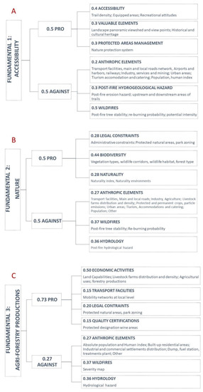
Figure 3.
Criteria used for the objectives: (A). Accessibility; (B). Nature; (C). Agricultural and forestry production.
Generally, the selection of the set of evaluation criteria, based on the expert panel’s proposals, is the most critical part of the approach, because the criteria have to be appropriate and exhaustive to reflect the aims of the work. This phase is also the most consuming of the entire process due to extensive collection and preparation of all GIS data needed as an input of the process. According to Malczewski [82,83,84,85], the evaluation criteria were selected pursuing the completeness (covering all the aspects of the decision problem); the operational ability (selecting criteria which are meaningful to a decision situation); the decomposability (allowing partitioning into a subset of criteria); the non-redundancy (avoiding the double-counting of decision consequences); and the minimalism (obtaining the smallest complete set of criteria characterizing the consequences of the decision).
Even if not exhaustive of the territory complexity, the experts identified the criteria representative of the main physical, biological, anthropic, and socio-cultural components of interest with respect to the study aims and in accordance with the holistic principle. With the experts’ support and the hydrologist team, the post-fire trees stability, the re-burning probability, the potential intensity, the post-fire erosion hazard and the upstream and downstream areas of trail maps were processed and used in the S-MCDA process of each criteria-tree (Annex SA in Supplementary Materials).
In each objective tree, the criteria are articulated in two main branches: “PRO” and “AGAINST”. These branches represent the supporting or limiting conditions, respectively, referring to the specific objective improvement. The criteria were selected based on IUCN objectives for the National Parks Category [26] and according to the completeness, decomposability and operational ability requirements [33,35,85,86,87]. Then, based on data availability, the proposed set of criteria was defined based on to the non-redundancy and minimalism requirements for each objective, and with the support of the panel of experts. Figure 3 shows the three criteria trees and Annex SA in Supplementary Materials summarizes all database and GIS tools used to process all of the attributes.
GIS raster maps were developed (one for each attribute). A standardization process was needed in order to transform map values into comparable units. The linear scaling method based on the cost/benefits function [88] was used. As consequence, all maps were standardized, with common values ranging from 0 to 1.
Different studies [84] present various weighting methods to derive the weights of underlying sub-indicators; among these, the expert opinion and analyst judgment play an important role in deriving these weights, and they therefore affect the quality of the process. The panel of experts assigned the weights to each attribute and cluster according to the criteria tree hierarchical structure by means of a rating technique and after a brief training about the effects of different weights [37,80,89,90]. This technique has the advantage of allowing the change or the addition of the alternatives/factors considered, allowing the process to continue from the last scores obtained without having to restart from the beginning. By means of an S-MCDA model in ILWIS software [91] and according to the hierarchical tree structures, all the weights expressed by the panel of experts were then normalized.
The S-MCDA was carried out using the weighted linear combination aggregation method because it retains the variability of factors [82,91]. This procedure is characterized by full trade-off and average risk [38]. Ranks and weights are assigned depending on their influence on the three objectives according to Equation (1):
where Pi is the suitability result value in the i-th cell in relation to n variables/factors; n is the number of input factors; wj is the weights assigned by the panel of experts to the factor j, normalized to give 1 as sum; and xj is the standardized criterion score of factor j.
The “suitability maps” resulting from each fundamental objective were classified with the “natural break” function into five classes. This function was preferred because it allows for the optimization of the set of values arranged into classes composed of items with similar characteristics that form a “natural” group within a data set [92,93,94,95]. A sensitivity analysis was processed with the support of the multi-criteria platform (the decision making module in the spatial-multi-criteria evaluation tool) of ILWIS software. Specifically, the variation in the judgments on assigned weights was applied. This analysis made it possible to observe the degree of influence of each factor on the final decision, highlighting the variables of greatest interest and those that could be eliminated. The resulting suitability maps, reporting the suitable areas that strongly meet the three objectives, had been overlaid in order to highlight any redundancy, and then also with the maximum fire severity degree areas in order to identify the priority intervention areas.
2.4. Ecosystem Services Valuation
According to the aim of the study, in this section the ecosystem services assessment is developed at landscape scale, referring to two time-steps and according to two different approaches. The landscape scale of analysis, starting from specific values associated with each land cover class, is based on the summary and interpolation of local data. The landscape approach allows for the obtaining of the total evaluation and knowledge of the phenomenon behavior (the impact of wildfires on the territory) on a broad scale (the entire Vesuvius Park) rather than at field scale, based on a situ-specific and analytic analysis. The analysis is performed referring to pre-fire conditions, starting from the Corine land Cover 2012 landscape pattern, and the immediate post-fire conditions, basing on the integrated Corine Land Cover 2018 pattern. Although the wildfires occurred over a period of less than two months, it is well-known that the effects are distributed over time: from immediate to medium to long term. As a main effect, the fires reduce vegetation density and thus increase the availability of bare-soils [96,97,98,99,100], with consequences on erosion risk, loss of carbon sequestration capacity, habitat losses for pollinators and biodiversity, etc. Specific times for restoration are required which exceed the seasonal duration. According to these considerations, the ES assessment is expressed as total value associated to hectares for the year. The present work uses two different approaches for the estimation of ecosystem services for different purposes and in different work steps. Specifically, the first one is the monetary approach, based on the benefit transfer method as an overall, immediate and easily transferable assessment of the benefits of the natural capital to people. The second approach integrates the panel of expert opinion (the same of the S-MCDA process) with the spatial modelling and biophysical assessment of specific ecosystem services. The aim was to target the study towards the specific factors involved in the 2017 fires by means of site-specific data.
According to Kubiszewski’s analysis [101], four levels of ES value aggregation models were identified: (i) basic value transfer, in which values are constant over the landscape classes; (ii) expert modified value transfer, in which expert opinions modify ES values at local scale; (iii) statistical value transfer, in which values are linked to statistical models related to context; and (iv) spatially explicit functional modelling, in which values are inserted into system models, whether dynamic or spatially explicit. In this paper the monetary quantifications of ESs [54] were determined by associating the value of the four ES types (coefficient) with the ES monetary values associated to each land use class of the study area, as in Equation (2):
where VSEi,k is the value (€/year) of i-ES for a k-polygon of a defined land use; Ak is the k-polygon area (ha), wi is a coefficient ranging from 0.5 to 1 depending on i-ES and each LC class considering context variables (Habitat quality, Recreation; Pollination; Sediment delivery ratio); vi is the monetary value of i-ES for defined LC (€/ha). Specifically, the factor wi is the potential of a specific LC class to provide a defined ES in the pre and post-fire phase, from a negligible level (0.5) to full capacity (1). According to the BTM approach, the monetary values vi were gained from Scolozzi et al. 2012 and updated to 2021 [54], setting the specific conditions of study area to the project requirements.
The present paper entails three steps in ES assessment as a measure of wildfire impact:
- Definition of ES monetary values (€/ha per year, as unique values for each land cover class, according to basic transfer methods—BTM), and their literature reference;
- Adjustment of the ES constant values, referring to local context-specific conditions, by means of the identification and processing of specific coefficients (with the panel of expert support and spatially modelling and biophysical assessment);
- Processing and comparing the results in the pre-wildfire 2017 and post-wildfire 2018 phases, highlighting changes in values according to spatial-explicit estimation methods (SEM).
CORINE Land Cover 2012 and 2018 maps were used, accompanied with more detailed land cover information, as detailed in the following. The forest types map, provided by the park authority, was used to better detail the coverage of natural areas within the park. CLC classes 331, 332 and 333 were replaced by the detailed forest coverings of the “Forest types” map (2010) (ESRI ArcGIS, Clip and Union tools). As a matter of fact, the CLC minimum mapping unit of 25 ha may be limiting at the local scale, especially where the landscape shows high fragmentation, as in the case of Vesuvius slopes. Despite the fact that the CLC accuracy is at least 85%, a focus on the forestry surface of the study area showed a drop down to 68.4%, mainly due to the misleading of the CLC in detecting coniferous forests, generally classified as mixed forest. Specifically, pine forests composed mainly by stone pine (Pinus pinea), less by maritime pine (Pinus pinaster) and black pine (Pinus nigra), often occur as a complex pattern of small surfaces, far lower than the threshold of 25 ha, decreasing the CLC map accuracy, in these specific areas, by 68%.
The post-fire re-classification map was obtained from remote sensing and field surveys, conducted by the members of the panel of experts. The fire gradients in the different areas were obtained from the Copernicus Emergency Management Service website and was considered as reference data. The map displays four levels of burn severity: completely destroyed areas (in which vegetation was totally destroyed by fire), while the other classes (from 3 to 1) identify those with 50%, 30% and no damage to vegetation, respectively. Based on the completely burned areas, within the areas of 50% and 30% of the vegetation destroyed, buffer areas with hypothetical completely destroyed vegetation were created, surrounding the perimeter of areas with trace of fire using the principle of spatial contiguity and according to the fire severity degree. Specific random checks were conducted to test the accuracy of the map.
Starting from the literature review [98,99,100,101], CORINE land cover classes were associated to the different ES land use classes or biome. First the ES monetary values (€/ha per year) for each land-cover class (Table 1) were defined. The method used started with Scolozzi’s, which was derived from a wide literature review (63 international studies). Only the average value for each land cover class was considered as an appropriate value for both the Italian and Campania context. Scolozzi’s monetary values were then updated according to the “monetary revaluations” calculator tool, available from the Italian National Statistical Institute (ISTAT).

Table 1.
Baseline monetary values (€/ha/y), according to type of ES (column) and land cover classes (row).
Following this, specific coefficients corresponding to the four biophysical ES type values, namely wi, were processed. The coefficient expresses the potential of LC classes to provide a defined ES ranging from 0 to 1. It is derived from local context-specific conditions. Specifically, the spatial distribution of biophysical values of the four specific ES types were processed and used as coefficients in the Equation (2).
The coefficient wi was sorted out from the InVEST (Integrated Valuation of Ecosystem Services and Trade-offs) open-source software [102]. It was adopted thanks to its ability to measure, estimate and map the potential of ecosystems in the supply of goods and services for people.
For each ES type, a raster spatial distribution map was processed according to the equations reported in annex B. Once the four ES types’ maps were sorted out, they were processed another time in order to obtain the wi coefficient dataset for Equation (2). The resulting four different scale units, derived by InVEST modules, were converted in a new dimensionless index, ranging from 0.5 to 1 by applying rescale by function in the GIS Reclass tools. The entity of the decrease was defined by the panel of experts based on field sampling for damage assessment. The fire did not completely affect the provision of ecosystem services; nevertheless, it certainly limited their production by at least 50%. A linear transformation function was adopted. The new values arise from the observation that, in many ecosystems, fire is an important process that contributes to habitat quality, even if often not in the short term [103,104,105,106,107]. In the present work, the observation period was July 2017–July 2018, highlighting the immediate effects of the fires: from the temporary loss of habitat to the loss of tourism, or from the hydrogeological risk increase to the reduction of agricultural production due to the absence of pollinators. The MAP Algebra tool was used to process Equation (2). The maximum ES value was obtained if the coefficient was equal to 1, and it becomes half if the coefficient is 0.5. All intermediate values were also calculated according to the linear function adopted.
Comparing to the first step method (the Benefit Transfer Method), the approach which integrates the panel of expert opinion with the spatially modelling and biophysical assessment of specific ecosystem services provides a more articulate analysis of the study area. As a matter of fact, beyond the maximum and minimum values of difference, this method provides a series of intermediate gradations depending on the specific landscape features and the assessed criteria. Moreover, the integrated method allows for the observing of the possible effects of the wildfire to be inferred not only for the burnt areas, but also for the adjacent ones, thanks to the evaluation of specific ecosystem services, which have significant repercussions and effects on wide areas (erosion phenomena, distribution of pollinators, ecological corridors, etc.).
3. Results
3.1. Identification of Priority Intervention Areas Results
As an intermediate output, three maps are shown from the S-MCDA process, highlighting the “areas of interest”. Figure 4A–C shows the suitability degree according to the Natural Breaks classification technique. The comparison among the three suitability maps shows that the areas with very high and high values are not always coincident with each other, as expected by their very definition (Annex SB in Supplementary Materials). It should be emphasized that the suitability degree resulting from the S-MCDA is a dimensionless value, ranging from 0 to 100. The classification into five classes, carried out through the Natural Breaks function, allows for the characterization of the entire park according to the degree of interest in each of the three fundamental objectives. In this phase of the work, only the areas with “high value” were considered.

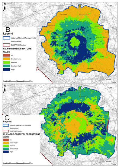
Figure 4.
(A) Suitability map—Accessibility. (B) Suitability map—Nature. (C) Suitability map—Agro-Forestry productions. Non English contents are place names.
Specifically, the Nature and the Accessibility high suitability areas were shown to have 1500 ha in common; these common areas represent the 97% of the total nature highly suitable areas and 50% of the total accessibility highly suitable areas. On the contrary, the agroforestry production objective shows a limited area (459 ha) in common with the other two objectives in the south-east of the park. The “All Objectives” layer was obtained as the sum of areas classified as “high level” belonging to each objective map (Nature, Accessibility and Agro-Forestry).
As final results, the “Priority Intervention Areas” were sorted out by the overlapping of the highly suitable areas of the three objectives (the “All Objectives” layers) with the maximum degree (class 4) of the 2017 Wildfire Severity map. They consist of 660 ha (Figure 5) and correspond to 4% of the total park area and 10% of the areas burned in 2017. As a consequence, the PIAs building process integrates both specific considerations about the wildfire severity degree and the functionality of the park area for the three aspects investigated. The immediate effect is the focusing of both economic and material resources, not only on those areas directly affected by fires, but also on adjacent areas of high importance for biodiversity and naturalness, for recreation, tourism and production. The objective of this identification is to identify restricted areas under an integrated planning and programming point of view in order to trigger wider natural processes that can favor reduced recovery times.

Figure 5.
The Priority Intervention Areas (PIAs). Non English contents are place names.
Inside the Priority Intervention Areas, mainly located on the South-East slope of Mt. Vesuvius pure coniferous stands, mixed stands (broadleaves and coniferous), and complex cultivation patterns were the land use classes most affected (CUAS 2009 map). The overlay of Priority Intervention Areas and the Erosion Risk map showed areas of interest from the South to the Southwest area of the Park. These areas already presented a high risk of hydrogeological instability, which is likely to increase due to the wildfires of 2017. Finally, the Priority Intervention Areas belong to areas A (full Reserve) and B (Oriented General Reserve), considering the Vesuvius National Park zoning map, which defines the uses and limits of interventions in each area (Annex SC in Supplementary Materials).
3.2. Ecosystem Services Valuation Results
According to the Benefit Transfer Method, the ES monetary average value of the whole Vesuvius National Park area, in the pre-fire phase, was equal to 3403.5 €/ha/y, and it declined to 2573.48 €/ha/y in the post-fire phase (Table 2). A decrease in the ecosystem services value of approximately seven million euros per year corresponding to about the 25% of the total value of the protected area was observed in the immediate post-fire (Figure 6A,B).
Table 2.
ES assessment by means of baseline value and integrated values by means of landscape variables.
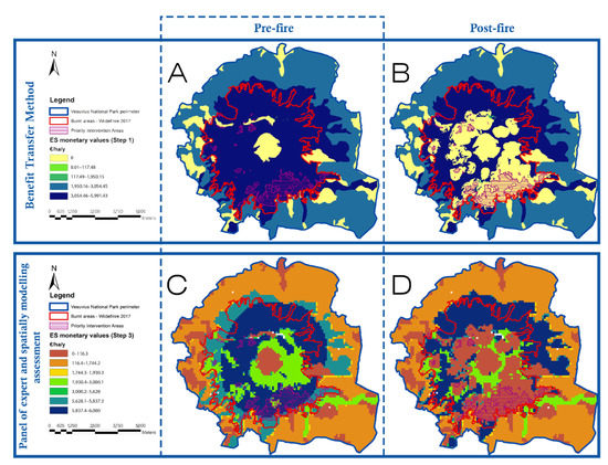
Figure 6.
Comparison of the ESs monetary values results: (A,C) are related to the pre-fire condition with the Benefit Transfer Method (BTM) and the Spatial-Explicit Method (SEM); (B,D) are related to the post-fire condition with BTM and SEM.
Starting from the approach, which integrates the expert panel’s opinions and the spatial modelling assessment, Step 3 of the framework, four maps concerning the selected ES (Habitat quality, Pollination, Recreation, Sediment Delivery Ratio) were developed with biophysical values, in pre- and post-fire phases, using InVEST software (Annex SD in Supplementary Materials). Pollination and Habitat refugium show the most relevant variations, due to the wildfire, with a reduction of up to 80% of the value inside the burned areas. Figure 6C,D shows that, in the whole Vesuvius National Park area, the loss of monetary value amounts to about € 6.6 M per year, with a parallel trend compared to the BTM. For instance, the loss of monetary value amounts to about 25% inside the total Vesuvius National Park area, 40% in burned areas, and more than 80% in Priority Intervention Areas. The average ES value in Vesuvius National Park, in the immediate post-fire phase, is 2406 €/ha/y, compared to the average regional value of 2407 €/ha/y.
The two final maps (Figure 7) show where the reduction in ESs is spatially concentrated and the magnitude of this reduction. The area involved by the change is 1920 ha, unlike the 1380 ha of the baseline value method. The variable integrated method shows that even the unburned areas are susceptible to damage due to the close spatial and functional relations (in this paper they are expressed by using ES indexes and variables) with the burned areas.
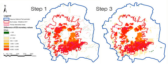
Figure 7.
ESs Difference of Monetary Values results in pre-fire and post-fire phases, in Step 1 and Step 3.
The results support the aim of the work because:
- with regard to the PIAs, they allow for the identifying of a limited area in which to concentrate, in the early post-fire phases, resources of means and money to favour the re-activation (spontaneous or guided) of ecosystem recovery processes (660 ha against the 3350 ha covered by wildfires and the 1200 ha with a high and very high degree of fire severity);
- with regard to the ESs assessment, they provide objective values to be discussed, both in terms of natural heritage to be protected and enhanced, and also in relation to neighboring territories and in terms of estimating the damage and raising awareness of local communities and decision-makers on the wildfire risk and the protected areas management;
- with regard to the ES mapping, they show a significant coincidence between the PIAs and the areas with the greatest damage of ESs, highlighting the strategic role of PIAs from the perspective of ecosystem recovery.
4. Discussion
This study advances a reference framework for a new strategy for wildfire management into protected areas, founded on the core approaches typical of landscape planning, which integrate different aspects and objectives characterizing these specific contexts in the Mediterranean basin. Starting from the specific conditions of Vesuvius National Park, the present work is in line with adaptive resilience strategies which entail zoning or land-use planning, proactive planning, management and infrastructure strategies [43,106]. The novelty in the present work is the action framework development, which, in the general articulation of the DPSIR model, identifies in the S-MCDA and in the Ecosystem Services approach, the strategic points of action, to improve the hydrological safety and interaction with high-intensity, potentially catastrophic fires. Even if the S-MCDA approach is widely used in risk management [83,107,108], it is still not studied very often and applied in cases of wildfires, because the fire prone-areas are usually conceived only as ecosystems, with predominantly naturalistic interests. The specific typology of European parks, and Vesuvius National Park in particular, merged in highly anthropized contexts and currently marked by rapid land-use change, has shown that the multi-criteria approach is particularly useful in protected areas as well. Moreover, the ecosystem services approach, which is increasingly used in the estimation of environmental damage [109,110,111], also allowed for the validation of the model for the identification of PIAs. The approaches used in the present work are proving to be very useful in landscape and land-use planning and decision-making support [112,113,114,115], and therefore they are increasingly used, raising the issue of the uncertainties associated with them: the unavoidable incomplete and inaccurate data contributing factors, rules governing how the input data are combined into susceptibility values, and parameters used in the combination rules [116,117,118]. In the specific case of a wildfires, for example, part of these uncertainties come from the visual interpretation (positional and thematic accuracy of the underlying data such the end user of data) of remote sensing data, which are crucial for the specific knowledge and expertise [118], in order to classify the state of land cover in the pre and post-fire phases. Moreover, the potentially large number of parameters and the heterogeneity of data sources, such as the variability of expert opinions and weights assignment [119,120,121,122], also have significant effects on the results. Handling errors and uncertainty in S-MCDA plays a considerable role in decision-making [122], quantifying outcome variability, giving model input uncertainties, and, therefore, helping to reduce uncertainties. The next steps of the work will be the implementation and the validation of proposed processes and outcomes by means of robust uncertainty and a sensitivity analysis, such as the use of objective methods in expert opinion weighting. These methods, in contrast to the subjective approach used in the present paper, provide flexibility in weight assignment depending on the variation of the local system and thus could improve and make the framework more applicable and simpler, allowing it to also be used in other contexts and regarding other aims.
4.1. Identification of Priority Intervention Areas
With regard to the “areas of interest” maps, they show the mutual competing aims and the overlapping of the objectives, highlighting strengths and weaknesses.
The most interesting aspects were:
- The intersection map between accessibility and nature high-value zones, which highlights the areas in which accessibility and touristic use are closely connected with the natural value of the context and allows for the recognition that park accessibility is linked to natural conditions, but the natural conditions are not necessarily linked to the fruition of the area.
- The intersection map between high-value accessibility and the agroforestry production areas shows that, in the current park fruition circuits, there is no suitable exploitation of productive resources. The awareness of the important and high-quality agricultural production in the study areas, underlined by brands and certification, can support the decision-makers in the planning of paths/circuits/internal roads network integration with dedicated food and wine itineraries.
- The intersection of the three areas of interest maps ultimately shows the areas (about 700 ha) which, under ordinary management of the park, may be considered the best in terms of fruition, biodiversity conditions and agro-food production, with regard to supporting the local socio-economic development and its population.
The approach adopted together with the action framework proposed allows the different components characterizing the park to be considered together and to integrate the prevention wildfire risk strategies by those connected to (i) plan the design of new nature-based and rural development paths which could enhance the socio-economic value of the northern area of the park and its related food and wine production; (ii) to manage natural areas and strengthen nature conservation policies in a context with high human pressure; and (iii) to promote new quality and protected certifications of origin, to implement and boost the sale of forest non-wood products, such as pine nuts of stone pine and honey. As an added benefit, the present approach helps to establish a multi-sectoral interdisciplinary information platform that can also be consulted for other management objectives.
Regarding the Priority Intervention Areas, their intersection with land-use maps showed that the forest was the area most severely affected by fire. It is likely that in these contexts, which are not profitable in economic terms, private owners will not undertake any restoration action. The park zoning highlights that the Priority Intervention Areas fall within the highest level of protection. The actions that may be undertaken in these areas, if connected to the principles of conservation of biodiversity, soil erosion control and mitigation of hydraulic risk, could meet the provisions of the urban-planning legislation, for example, having a bias toward the restoration with naturalistic engineering techniques using native shrub and tree species. The overlay with the erosion risk map highlighted the need to mitigate the high erosive risk areas of the northwestern sector, but also the southeastern slopes which overhang highly vulnerable areas, despite its lower erosive risk. As a matter of fact, priority areas identify burned forest where severity of fire affected the andic soil properties, mineralizing its stock of organic matter [123,124] and depleting aerial and soil seeds and bud banks. Subsequently, bare burned soil becomes highly prone to erosion events, [125] and becomes a priority for post-fire restoration actions [126]. Finally, interesting reflections can be derived from the first step of the sensitivity analysis. As a matter of fact, this analysis demonstrates the robustness of the model applied, since the areas of high suitability (the PIAs) show a good overlap among the three objectives. A further reflection must be made with respect to multi-criteria evaluation methods and their implementation in the landscape planning and management process. In several studies concerning the priority areas, identification of the subjective weighting, objective weighting, and decision-making with multiple experts are not considered at the same time. Thus, although the assessment approaches have evolved during the past years, more multicriteria approaches able to quantify the objective and subjective weights simultaneously still need to be developed and extended. The next steps of this work could be devoted to test the subjective method used in the present paper with objectives ones, such as Entropy and TOPSIS [116,117].
4.2. Ecosystem Services Evaluation Land-Use/Landscape
With regard to the ES valuation, the proposed approach allowed for the assessing of pressures and the current state of the study area, starting from the provision of different ES at macro-analysis level. Potential effects were evaluated by comparing maps on the ES provision in the pre- and post-fire scenarios. It is useful to observe that the pre- and post-fire phases refer to two static scenarios built on the basis of the Corine land Cover of 2012 and of the Corine 2018, with the integration of the map of forest types. The work does not deepen the fire occurrence time, as the study is aimed at contributing to landscape planning. The aim is to estimate the landscape ecosystem values and to support the decision-makers in organizing strategies and interventions from a system perspective, which brings natural aspects together with socio-economic ones. The aim was to support the development of appropriate wildfire response measures. According to the literature [49,63,114,115], the paper proposes to link the ES analysis and assessment in a closer, more dynamic and structured way within the land-use/landscape management procedure (DPSIR-based approach) [112,127,128,129,130]. The ES analyses became a useful indicator for monitoring, which had to be integrated into the ordinary existing landscape planning instruments (such as the Plan of the Park, Strategic Environmental Assessment, and Nature 2000s area management plans), in order to verify the system asset, to share results with a transparent process and to support decision-makers and communities in landscape governance.
As source of data, starting from different studies’ analysis devoted to the Italian context [124,125,131,132], the monetary values sorted out from Scolozzi’s work were adopted (expressed as €/ha/year) because they refer to different ES types, allowing a general assessment of the ecosystem services provided by the land. The ES valuation by means of a monetary value approach has the benefit of giving a quantitative parameter to objectively compare different land-use configurations, which is a useful tool to link with the S-MCDA approach in order to hypothesize and compare alternative scenarios.
As first results, the average value of the whole Vesuvius National Park area, in the pre-fire phase (equal to 3403.5 €/ha/y), compared to the average value of the Campania Region (equal to 2555 €/ha/y), highlights the importance of the protected area for ecosystems preservation (+33%). Although the VNP is one of the protected areas most subjected to anthropogenic pressure, inserted in Naples metropolitan area with high population density, infrastructure and urban settlements among the highest in Europe, it is nonetheless a supplier of high levels of ecosystem services for the population. The protection and conservation policies, with particular regard to the prevention of fire risk, must be implemented in order to preserve all of the functions of the Park. In addition, the approaches used justify the value gap between ordinary/protected areas mainly on the basis of natural and semi-natural coverages. Starting from the role that protected areas play for the population, in terms of ecosystems, recreation, science, rarity, it is believed that this gap is greater and must be investigated in the next steps of this work. Further collaboration with economists could help to quantify the added value of the studied area. Therefore, the benefit of ES valuation could be twofold: firstly, it could reinforce nature protection policies (in accordance with institutional aims) and, secondly, it may promote park development according to the needs of the local population.
It is interesting to observe that, in relation to human benefit, the Priority Intervention Areas (4% of the park area) before the wildfire in summer 2017 represented 14% of the total park ES value, highlighting the importance of the areas identified through the S-MCDA approach. The comparison of pre- and post-fire values makes it possible to estimate the damage: in both steps, the ecosystem services value loss is approximately one quarter of the entire park area, 44% for the burned areas, and almost 80% for the Priority Intervention Areas alone. This allows us to validate the approach used to identify the priority intervention areas and to focus on the mitigation measures on the targeted areas, which could become strategic for the reforestation programs.
The present work should be integrated into future project steps in order to deepen the monetary added value of the protected natural areas, integrating other ES value transfer techniques such as value function transfer or meta-regression analysis function transfer. ES valuation has been performed on other parks or protected areas [133,134], but a comparison between parks and regional landscape values is generally lacking. Next steps could also be connected with other aspects related to the wildfire risk investigation, such as fire occurrence time or the burning stages.
Further developments of the present work will be the valuation of the impact of two possible succession trajectories of the ecosystems: natural recruitment by native species and assisted afforestation.
5. Conclusions
In addition to their natural function of biodiversity support, wildfires are increasingly discussed as a “problem” of which humanity plays a central role and has responsibility for. The size of the fires in Amazonia, Australia, California, and Mediterranean Europe that occurred in the last few years have highlighted the local and global consequences of their effects. A structured approach is necessary to face the risks of biodiversity loss, landscape and damages in the wildland-urban interface.
The proposed framework aims to integrate different approaches typical of ordinary landscape planning as effective responses to environmental risks, within the Protected Areas (National Park) category. The main outcomes of this approach are the rapid and efficient identification of priority intervention areas as a result of fires, and a simultaneous quantification of the immediate damage, in order to support the actions of decision-makers, the managing authorities and the local communities, with regard to the strategies and interventions to be implemented. This integration of different approaches applied to protected areas is essential to move from the current fire management systems, based on forest management strategies, to a more effective and pro-active fire management approach, which also includes the socio-economic dynamics of these contexts.
The work entailed two phases. In the first one, the S-MCDA method was used to identify the priority intervention areas. The probabilistic method proved its viability and reliability also in the specific context traditionally considered only in terms of nature conservation and referring to the wildfire risk management systems. Specifically, the S-MCDA approach supported the basis of a medium-long term development planning process, providing the necessary tools to evaluate different intervention scenarios. The study made it possible to highlight: (i) critical issues, e.g., the lack of homogeneity in the network of infrastructures or the need for specific fire risk management solutions; (ii) and new opportunities, e.g., the promotion of new food quality certifications. Discussions concern both the ordinary management and the wildfire risk management of the Vesuvius National Park. In the second phase of the work the ES valuation by means of both the benefit transfer method and the spatial-explicit estimation method has proved its reliability and utility not only quantitatively in economic terms, but also in spatial distribution terms. The developed evaluation endeavored to efficiently allocate monetary resources for the restoration of fire-damaged areas in a natural protected area.
The proposed approaches allowed for the recognizing of the indirect fire effects on areas larger than those burned, supporting the need for a multidisciplinary and multiscale approach with respect to forest fires in Mediterranean ecosystems.
This innovative approach focused on the wildfire management of protected areas, provides arguments for adapting landscape planning and management tools to reduce the vulnerability of territories and societies, and provides the park management authority with a multitasking tool for landscape analysis which can be updated and used for other aspects (disturbances) affecting the park. The present work, starting from the wildfire effect analysis in a local and specific context, aimed to suggest an action framework that may be useful for other risk typologies and in other parts of the world.
Supplementary Materials
The following supporting information can be downloaded at: https://www.mdpi.com/article/10.3390/land11071024/s1, Annex SA. Criteria trees. Annex SB. Equations. Annex SC. Comparing maps. Annex SD. Invest maps.
Author Contributions
The authors contributed in: E.C. Conceptualization, Methodology, Software, Data curation, Writing—Original draft preparation, Writing, Investigation, Funding acquisition; S.P. Writing—Original draft preparation, Supervision. E.A., L.S., R.S. and E.S.d.P. Investigation; A.S. Supervision, Funding acquisition. All authors have read and agreed to the published version of the manuscript.
Funding
“This research was funded by the “Convenzione Parco Nazionale del Vesuvio—Dipartimento di Agraria”, assigned to prof. Antonio Saracino; the Regione Campania Italy (Rural Development Program for 2014–2020 of Campania Region), under the following projects: “GATES” and “SEI CON il Vesuvio” (assigned to E. Cervelli).
Institutional Review Board Statement
Not applicable.
Informed Consent Statement
Not applicable.
Conflicts of Interest
The authors declare that they have no conflict of interest. The funders had no role in the design of the study; in the collection, analyses, or interpretation of data; in the writing of the manuscript, or in the decision to publish the results.
References
- Keeley, J.E.; Bond, W.J.; Bradstock, R.A.; Pausas, J.G.; Rundel, P.W. Fire in Mediterranean Ecosystems: Ecology, Evolution and Management; Cambridge University Press: New York, NY, USA, 2011. [Google Scholar]
- Tedim, F.; Leone, V.; Amraoui, M.; Bouillon, C.; Coughlan, M.R.; Delogu, G.M.; Fernandes, P.M.; Ferreira, C.; McCaffrey, S.; McGee, T.K.; et al. Defining Extreme Wildfire Events: Difficulties, Challenges, and Impacts. Fire 2018, 1, 9. [Google Scholar] [CrossRef] [Green Version]
- Pausas, J.G.; Keeley, J.E. Wildfires as an ecosystem service. Front. Ecol. Environ. 2019, 17, 289–295. [Google Scholar] [CrossRef] [Green Version]
- McLauchlan, K.K.; Higuera, P.E.; Miesel, J.; Rogers, B.M.; Schweitzer, J.; Shuman, J.K.; Tepley, A.J.; Varner, J.M.; Veblen, T.T.; Adalsteinsson, S.A.; et al. Fire as a fundamental ecological process: Research advances and frontiers. J. Ecol. 2020, 108, 2047–2069. [Google Scholar] [CrossRef]
- Pausas, J.G.; Llovet, J.; Rodrigo, A.; Vallejo, R. Are wildfires a disaster in the Mediterranean basin?—A review. Int. J. Wildland Fire 2008, 17, 713–723. [Google Scholar] [CrossRef]
- Bowman, D.M.; Balch, J.K.; Artaxo, P.; Bond, W.J.; Carlson, J.M.; Cochrane, M.A.; D’antonio, C.M.; Defries, R.S.; Doyle, J.C.; Harrison, S.P.; et al. Fire in the Earth system. Science 2009, 324, 481–484. [Google Scholar] [CrossRef]
- Harvey, B.J. Human-caused climate change is now a key driver of forest fire activity in the western United States. Proc. Natl. Acad. Sci. USA 2016, 113, 11649–11650. [Google Scholar] [CrossRef] [Green Version]
- Boer, M.M.; Nolan, R.H.; De Dios, V.R.; Clarke, H.; Price, O.F.; Bradstock, R.A. Changing weather extremes call for early warning of potential for catastrophic fire. Earth’s Future 2017, 5, 1196–1202. [Google Scholar] [CrossRef]
- Stevens-Rumann, C.S.; Kemp, K.B.; Higuera, P.E.; Harvey, B.J.; Rother, M.T.; Donato, D.C.; Morgan, P.; Veblen, T.T. Evidence for declining forest resilience to wildfires under climate change. Ecol. Lett. 2018, 21, 243–252. [Google Scholar] [CrossRef]
- Urbieta, I.R.; Zavala, G.; Bedia, J.; Gutiérrez, J.M.; San Miguel-Ayanz, J.; Camia, A.; Keeley, J.E.; Moreno, J.M. Fire activity as a function of fire–weather seasonal severity and antecedent climate across spatial scales in southern Europe and Pacific western USA. Environ. Res. Lett. 2015, 10, 114013. [Google Scholar] [CrossRef] [Green Version]
- Oliveira, S.; Félix, F.; Nunes, A.; Lourenço, L.; Laneve, G.; Sebastián-López, A. Mapping wildfire vulnerability in Mediterranean Europe. Testing a stepwise approach for operational purposes. J. Environ. Manag. 2018, 206, 158–169. [Google Scholar] [CrossRef]
- Morvan, D. Wildfires modelling: Short overview, challenges and perspectives. J. Combust. Soc. Jpn. 2019, 61, 120–125. [Google Scholar]
- Moinuddin, K.A.M.; Sutherland, D. Modelling of tree fires and fires transitioning from the forest floor to the canopy with a physics-based model. Math. Comput. Simul. 2020, 175, 81–95. [Google Scholar] [CrossRef]
- Chuvieco, E. (Ed.) Earth Observation of Wildland Fires in Mediterranean Ecosystems; Springer: Dordrecht, The Netherlands, 2009; pp. 129–148. [Google Scholar]
- Millar, C.I.; Stephenson, N.L. Temperate forest health in an era of emerging megadisturbance. Science 2015, 349, 823–826. [Google Scholar] [CrossRef] [PubMed]
- Bowman, D.M.; Williamson, G.J.; Abatzoglou, J.T.; Kolden, C.A.; Cochrane, M.A.; Smith, A.M. Human exposure and sensitivity to globally extreme wildfire events. Nat. Ecol. Evol. 2017, 1, 0058. [Google Scholar] [CrossRef]
- Chuvieco, E.; Aguado, I.; Yebra, M.; Nieto, H.; Salas, J.; Martín, M.P.; Vilar, L.; Martínez, J.; Martín, S.; Ibarra, P.; et al. Development of a framework for fire risk assessment using remote sensing and geographic information system technologies. Ecol. Model. 2010, 221, 46–58. [Google Scholar] [CrossRef]
- Marino, E.; Hernando, C.; Planelles, R.; Madrigal, J.; Guijarro, M.; Sebastián, A. Forest fuel management for wildfire prevention in Spain: A quantitative SWOT analysis. Int. J. Wildland Fire 2014, 23, 373–384. [Google Scholar] [CrossRef]
- Meira-Castro, A.; Shakesby, R.A.; Marques, J.E.; Doerr, S.H.; Meixedo, J.P.; Teixeira, J.; Chaminé, H.I. Effects of prescribed fire on surface soil in a Pinus pinaster plantation, northern Portugal. Environ. Earth Sci. 2015, 73, 3011–3018. [Google Scholar] [CrossRef] [Green Version]
- Lasanta, T.; Khorchani, M.; Pérez-Cabello, F.; Errea, P.; Sáenz-Blanco, R.; Nadal-Romero, E. Clearing shrubland and extensive livestock farming: Active prevention to control wildfires in the Mediterranean mountains. J. Environ. Manag. 2018, 227, 256–266. [Google Scholar] [CrossRef]
- Geldmann, J.; Barnes, M.; Coad, L.; Craigie, I.D.; Hockings, M.; Burgess, N.D. Effectiveness of terrestrial protected areas in reducing habitat loss and population declines. Biol. Conserv. 2013, 161, 230–238. [Google Scholar] [CrossRef]
- Molina, J.R.; Silva, F.R.Y.; Herrera, M.Á. Integrating economic landscape valuation into Mediterranean territorial planning. Environ. Sci. Policy 2016, 56, 120–128. [Google Scholar] [CrossRef]
- Dudley, N. (Ed.) Guidelines for Applying Protected Area Management Categories; IUCN: Gland, Switzerland, 2008; Available online: https://www.iucn.org/theme/protected-areas/about (accessed on 14 July 2020).
- Bottero, M.; Comino, E.; Duriavig, M.; Ferretti, V.; Pomarico, S. The application of a Multicriteria Spatial Decision Support System (MCSDSS) for the assessment of biodiversity conservation in the Province of Varese (Italy). Land Use Policy 2013, 30, 730–738. [Google Scholar] [CrossRef]
- Dudley, N.; Stolton, S. Defining Protected Areas: An International Conference in Almeria, Spain; IUCN: Gland, Switzerland, 2008. [Google Scholar]
- IUCN WCPA. Guidelines for Applying Protected Area Management Categories Including IUCN WCPA Best Practice Guidance on Recognising Protected Areas and Assigning Management Categories and Governance Types. 2008. Available online: https://www.iucn.org/theme/protected-areas/about/protected-areas-categories/category-ii-national-park (accessed on 18 January 2022).
- San-Miguel-Ayanz, J.; Durrant, T.; Boca, R.; Libertà, G.; Branco, A.; de Rigo, D.; Ferrari, D.; Maianti, P.; Vivancos, T.A.; Schulte, E.; et al. Forest Fires in Europe, Middle East and North Africa. 2017. Available online: https://www.driver-project.eu/forest-fires-in-europe-middle-east-and-north-africa-2017-the-new-jrc-report/ (accessed on 30 April 2021).
- Alcasena, F.J.; Ager, A.A.; Bailey, J.D.; Pineda, N.; Vega-García, C. Towards a comprehensive wildfire management strategy for Mediterranean areas: Framework development and implementation in Catalonia, Spain. J. Environ. Manag. 2019, 231, 303–320. [Google Scholar] [CrossRef] [PubMed]
- Qureshi, M.E.; Harrison, S.R.; Wegener, M.K. Validation of multicriteria analysis models. Agric. Syst. 1999, 62, 105–116. [Google Scholar] [CrossRef]
- Mansourian, S.; Vallauri, D. (Eds.) Forest Restoration in Landscapes: Beyond Planting Trees; Springer Science & Business Media: Berlin/Heidelberg, Germany, 2005. [Google Scholar]
- Montiel Molina, C.; Galiana-Martín, L. Fire scenarios in Spain: A territorial approach to proactive fire management in the context of global change. Forests 2016, 7, 273. [Google Scholar] [CrossRef]
- Montiel-Molina, C.; Vilar, L.; Romão-Sequeira, C.; Karlsson, O.; Galiana-Martín, L.; Madrazo-García de Lomana, G.; Palacios-Estremera, M.T. Have historical land use/land cover changes triggered a fire regime shift in central Spain? Fire 2019, 2, 44. [Google Scholar] [CrossRef] [Green Version]
- Sequeira, C.R.; Molina, C.M.; Rego, F.C. Landscape-based fire scenarios and fire types in the Ayllón massif (Central Mountain Range, Spain), 19th and 20th centuries. Cuad. Investig. Geográfica/Geogr. Res. Lett. 2020, 46, 103–126. [Google Scholar] [CrossRef] [Green Version]
- Nijkamp, P. Multicriteria analysis: A decision support system for sustainable environmental management. In Economy and Ecology: Towards Sustainable Development; Springer: Dordrecht, The Netherlands, 1989; pp. 203–220. [Google Scholar]
- Koschke, L.; Fürst, C.; Frank, S.; Makeschin, F. A multi-criteria approach for an integrated land-cover-based assessment of ecosystem services provision to support landscape planning. Ecol. Indic. 2012, 21, 54–66. [Google Scholar] [CrossRef]
- Boggia, A.; Massei, G.; Pace, E.; Rocchi, L.; Paolotti, L.; Attard, M. Spatial multicriteria analysis for sustainability assessment: A new model for decision making. Land Use Policy 2018, 71, 281–292. [Google Scholar] [CrossRef] [Green Version]
- Malczewski, J. GIS-based multicriteria decision analysis: A survey of the literature. Int. J. Geogr. Inf. Sci. 2006, 20, 703–726. [Google Scholar] [CrossRef]
- Romano, G.; Dal Sasso, P.; Liuzzi, G.T.; Gentile, F. Multi-criteria decision analysis for land suitability mapping in a rural area of Southern Italy. Land Use Policy 2015, 48, 131–143. [Google Scholar] [CrossRef]
- Depietri, Y. The social–ecological dimension of vulnerability and risk to natural hazards. Sustain. Sci. 2020, 15, 587–604. [Google Scholar] [CrossRef]
- Bui, D.T.; Bui, Q.T.; Nguyen, Q.P.; Pradhan, B.; Nampak, H.; Trinh, P.T. A hybrid artificial intelligence approach using GIS-based neural-fuzzy inference system and particle swarm optimization for forest fire susceptibility modeling at a tropical area. Agric. For. Meteorol. 2017, 233, 32–44. [Google Scholar]
- Navarro, G.; Caballero, I.; Silva, G.; Parra, P.C.; Vázquez, Á.; Caldeira, R. Evaluation of forest fire on Madeira Island using Sentinel-2A MSI imagery. Int. J. Appl. Earth Obs. 2017, 58, 97–106. [Google Scholar] [CrossRef] [Green Version]
- Ianni, E.; Geneletti, D. Applying the ecosystem approach to select priority areas for forest landscape restoration in the Yungas, Northwestern Argentina. Environ. Manag. 2010, 46, 748–760. [Google Scholar] [CrossRef] [PubMed]
- Moreira, F.; Viedma, O.; Arianoutsou, M.; Curt, T.; Koutsias, N.; Rigolot, E.; Barbati, A.; Corona, P.; Vaz, P.; Xanthopoulos, G.; et al. Landscape–wildfire interactions in southern Europe: Implications for landscape management. J. Environ. Manag. 2011, 92, 2389–2402. [Google Scholar] [CrossRef] [Green Version]
- Molina, J.R.; Moreno, R.; Castillo, M.; Silva, F.R.Y. Economic susceptibility of fire-prone landscapes in natural protected areas of the southern Andean Range. Sci. Total Environ. 2018, 619, 1557–1565. [Google Scholar] [CrossRef]
- McWethy, D.B.; Schoennagel, T.; Higuera, P.E.; Krawchuk, M.; Harvey, B.J.; Metcalf, E.C.; Schultz, C.; Miller, C.; Metcalf, A.L.; Buma, B.; et al. Rethinking resilience to wildfire. Nat. Sustain. 2019, 2, 797–804. [Google Scholar] [CrossRef]
- Marey-Perez, M.; Loureiro, X.; Corbelle-Rico, E.J.; Fernández-Filgueira, C. Different strategies for resilience to wildfires: The experience of collective land ownership in Galicia (Northwest Spain). Sustainability 2021, 13, 4761. [Google Scholar] [CrossRef]
- Chaplin-Kramer, R.; Sharp, R.P.; Weil, C.; Bennett, E.M.; Pascual, U.; Arkema, K.K.; Brauman, K.A.; Bryant, B.P.; Guerry, A.D.; Haddad, N.M.; et al. Global modeling of nature’s contributions to people. Science 2019, 366, 255–258. [Google Scholar] [CrossRef]
- Fisher, B.; Turner, R.K.; Morling, P. Defining and classifying ecosystem services for decision making. Ecol. Econ. 2019, 68, 643–653. [Google Scholar] [CrossRef] [Green Version]
- Rozas-Vasquez, D.; Fuerst, C.; Geneletti, D. Integrating ecosystem services in spatial planning and strategic environmental assessment: The role of the cascade model. Environ. Impact. Asses. 2019, 78, 106291. [Google Scholar] [CrossRef]
- MEA: Millenium Ecosystem Assessment. Ecosystems and Human Well-Being; Island Press: Washington, DC, USA; World Resources Institute: Washington, DC, USA, 2005; Volume 5, p. 563. [Google Scholar]
- TEEB Foundations. The Economics of Ecosystems and Biodiversity: Ecological and Economic Foundations; Earthscan: London, UK; Washington, DC, USA, 2010. [Google Scholar]
- Plieninger, T.; Torralba, M.; Hartel, T.; Fagerholm, N. Perceived ecosystem services synergies, trade-offs, and bundles in European high nature value farming landscapes. Landsc. Ecol. 2019, 34, 1565–1581. [Google Scholar] [CrossRef]
- Wei, H.; Fan, W.; Lu, N.; Xu, Z.; Liu, H.; Chen, W.; Ulgiati, S.; Wang, X.; Dong, X. Integrating Biophysical and Sociocultural Methods for Identifying the Relationships between Ecosystem Services and Land Use Change: Insights from an Oasis Area. Sustainability 2019, 11, 2598. [Google Scholar] [CrossRef] [Green Version]
- Scolozzi, R.; Morri, E.; Santolini, R. Delphi-based change assessment in ecosystem service values to support strategic spatial planning in Italian landscapes. Ecol. Indic. 2012, 21, 134–144. [Google Scholar] [CrossRef]
- Costanza, R.; De Groot, R.; Sutton, P.; Van der Ploeg, S.; Anderson, S.J.; Kubiszewski, I.; Farber, S.; Turner, R.K. Changes in the global value of ecosystem services. Glob. Environ. Chang. 2014, 26, 152–158. [Google Scholar] [CrossRef]
- Kubiszewski, I.; Costanza, R.; Anderson, S.; Sutton, P. The future value of ecosystem services: Global scenarios and national implications. In Environmental Assessments; Edward Elgar Publishing: Northampton, MA, USA, 2020. [Google Scholar]
- Mose, I.; Weixlbaumer, N. A new paradigm for protected areas in Europe. In Protected Areas and Regional Development in Europe. Towards a New Model for the 21st Century; Routledge: London, UK, 2007; pp. 3–20. [Google Scholar]
- Jones, K.R.; Venter, O.; Fuller, R.A.; Allan, J.R.; Maxwell, S.L.; Negret, P.J.; Watson, J.E. One-third of global protected land is under intense human pressure. Science 2018, 360, 788–791. [Google Scholar] [CrossRef] [Green Version]
- Guerra, C.A.; Rosa, I.M.; Pereira, H.M. Change versus stability: Are protected areas particularly pressured by global land cover change? Landsc. Ecol. 2019, 34, 2779–2790. [Google Scholar] [CrossRef] [Green Version]
- Jones-Walters, L.; Čivić, K. European protected areas: Past, present and future. J. Nat. Conserv. 2013, 21, 122–124. [Google Scholar] [CrossRef]
- Smeets, E.; Weterings, R. Environmental Indicators: Typology and Overview; European Environment Agency: Copenhagen, Denmark, 1999. [Google Scholar]
- Maxim, L.; Spangenberg, J.H.; O’Connor, M. An analysis of risks for biodiversity under the DPSIR framework. Ecol. Econ. 2009, 69, 12–23. [Google Scholar] [CrossRef]
- Galler, C.; Albert, C.; von Haaren, C. From regional environmental planning to implementation: Paths and challenges of integrating ecosystem services. Ecosyst. Serv. 2016, 18, 118–129. [Google Scholar] [CrossRef]
- Moss, E.D.; Evans, D.M.; Atkins, J.P. Investigating the impacts of climate change on ecosystem services in UK agro-ecosystems: An application of the DPSIR framework. Land Use Policy 2021, 105, 105394. [Google Scholar] [CrossRef]
- Zebardast, L.; Salehi, E.; Afrasiabi, H. Application of DPSIR Framework for Integrated Environmental Assessment of Urban Areas: A Case Study of Tehran. Int. J. Environ. Res. 2015, 9, 445–456. [Google Scholar]
- Relvas, H.; Miranda, A.I. Application of the DPSIR framework to air quality approaches. Air Qual. Atmos. Health 2018, 11, 1069–1079. [Google Scholar] [CrossRef]
- Wang, W.; Sun, Y.; Wu, J. Environmental warning system based on the DPSIR model: A practical and concise method for environmental assessment. Sustainability 2018, 10, 1728. [Google Scholar] [CrossRef] [Green Version]
- Saulino, L.; Rita, A.; Migliozzi, A.; Maffei, C.; Allevato, E.; Garonna, A.P.; Saracino, A. Detecting burn severity across mediterranean forest types by coupling medium-spatial resolution satellite imagery and field data. Remote Sens. 2020, 12, 741. [Google Scholar] [CrossRef] [Green Version]
- Silvestro, R.; Saulino, L.; Cavallo, C.; Allevato, E.; Pindozzi, S.; Cervelli, E.; Conti, P.; Mazzoleni, S.; Saracino, A. The Footprint of Wildfires on Mediterranean Forest Ecosystem Services in Vesuvius National Park. Fire 2021, 4, 95. [Google Scholar] [CrossRef]
- Cowling, R.M.; Pressey, R.L.; Sims-Castley, R.; Le Roux, A.; Baard, E.; Burgers, C.J.; Palmer, G. The expert or the algorithm?—Comparison of priority conservation areas in the Cape Floristic Region identified by park managers and reserve selection software. Biol. Conserv. 2003, 112, 147–167. [Google Scholar] [CrossRef]
- Geneletti, D.; van Duren, I. Protected area zoning for conservation and use: A combination of spatial multicriteria and multiobjective evaluation. Landsc. Urban Plan. 2008, 85, 97–110. [Google Scholar] [CrossRef]
- Ruiz-Gallardo, J.R.; Castaño, S.; Calera, A. Application of remote sensing and GIS to locate priority intervention areas after wildland fires in Mediterranean systems: A case study from south-eastern Spain. Int. J. Wildland Fire 2004, 13, 241–252. [Google Scholar] [CrossRef]
- Hamadouche, M.A.; Mederbal, K.; Kouri, L.; Regagba, Z.; Fekir, Y.; Anteur, D. GIS-based multicriteria analysis: An approach to select priority areas for preservation in the Ahaggar National Park, Algeria. Arab. J. Geosci. 2014, 7, 419–434. [Google Scholar] [CrossRef]
- Mota, P.H.S.; da Rocha, S.J.S.S.; de Castro, N.L.M.; Marcatti, G.E.; de Jesus França, L.C.; Schettini, B.L.S.; Villanova, P.H.; dos Santos, H.T.; dos Santos, A.R. Forest fire hazard zoning in Mato Grosso State, Brazil. Land Use Policy 2019, 88, 104206. [Google Scholar] [CrossRef]
- De Natale, G.; Troise, C.; Pingue, F.; Mastrolorenzo, G.; Pappalardo, L. The Somma–Vesuvius volcano (Southern Italy): Structure, dynamics and hazard evaluation. Earth-Sci. Rev. 2006, 74, 73–111. [Google Scholar] [CrossRef]
- EUNIS. Available online: https://eunis.eea.europa.eu/habitats/10235 (accessed on 10 November 2021).
- Keshavarz-Ghorabaee, M. Assessment of distribution center locations using a multi-expert subjective–objective decision-making approach. Sci. Rep. 2021, 11, 19461. [Google Scholar] [CrossRef] [PubMed]
- Stroppiana, D.; Bordogna, G.; Carrara, P.; Boschetti, M.; Boschetti, L.; Brivio, P.A. A method for extracting burned areas from Landsat TM/ETM+ images by soft aggregation of multiple Spectral Indices and a region growing algorithm. ISPRS J. Photogramm. Remote Sens. 2012, 69, 88–102. [Google Scholar] [CrossRef]
- Scriban, R.E.; Nichiforel, L.; Bouriaud, L.G.; Barnoaiea, I.; Cosofret, V.C.; Barbu, C.O. Governance of the forest restitution process in Romania: An application of the DPSIR model. For. Policy Econ. 2019, 99, 59–67. [Google Scholar] [CrossRef]
- Albert, C.; Galler, C.; Hermes, J.; Neuendorf, F.; Von Haaren, C.; Lovett, A. Applying ecosystem services indicators in landscape planning and management: The ES-in-Planning framework. Ecol. Indic. 2016, 61, 100–113. [Google Scholar] [CrossRef]
- Saaty, T.L. Decision making with the analytic hierarchy process. Int. J. Serv. Sci. 2008, 1, 83–98. [Google Scholar] [CrossRef] [Green Version]
- Ferretti, V. A multicriteria spatial decision support system development for siting a landfill in the province of Torino (Italy). J. Multi-Criteria Decis. Anal. 2011, 18, 231–252. [Google Scholar] [CrossRef] [Green Version]
- Sharifi, M.A. Site selection for waste disposal through spatial multiple criteria decision analysis. J. Telecommun. Inf. Technol. 2004, 28–38. [Google Scholar]
- Tegou, L.I.; Polatidis, H.; Haralambopoulos, D.A. Environmental management framework for wind farm siting: Methodology and case study. J. Environ. Manag. 2010, 91, 2134–2147. [Google Scholar] [CrossRef]
- Malczewski, J. Visualization in multicriteria spatial decision support systems. Geomatica 1999, 53, 139–147. [Google Scholar]
- Rashed, T.; Weeks, J. Assessing vulnerability to earthquake hazards through spatial multicriteria analysis of urban areas. Int. J. Geogr. Inf. Sci. 2003, 17, 547–576. [Google Scholar] [CrossRef]
- Gbanie, S.P.; Tengbe, P.B.; Momoh, J.S.; Medo, J.; Kabba, V.T.S. Modelling landfill location using geographic information systems (GIS) and multi-criteria decision analysis (MCDA): Case study Bo, Southern Sierra Leone. Appl. Geogr. 2013, 36, 3–12. [Google Scholar] [CrossRef]
- Zarin, R.; Azmat, M.; Naqvi, S.R.; Saddique, Q.; Ullah, S. Landfill site selection by integrating fuzzy logic, AHP, and WLC method based on multi-criteria decision analysis. Environ. Sci. Pollut. Res. 2021, 28, 19726–19741. [Google Scholar] [CrossRef] [PubMed]
- Hatefi, S.M.; Torabi, S.A. A common weight MCDA–DEA approach to construct composite indicators. Ecol. Econ. 2010, 70, 114–120. [Google Scholar] [CrossRef]
- Malczewski, J. Local weighted linear combination. Trans. GIS 2011, 15, 439–455. [Google Scholar] [CrossRef]
- ILWIS, Integrated Land and Water Information System. Available online: https://52north.org/software/software-projects/ilwis/ (accessed on 14 January 2021).
- Michael, E.A.; Samanta, S. Landslide vulnerability mapping (LVM) using weighted linear combination (WLC) model through remote sensing and GIS techniques. Modeling Earth Syst. Environ. 2016, 2, 88. [Google Scholar] [CrossRef] [Green Version]
- Comino, E.; Bottero, M.; Pomarico, S.; Rosso, M. Exploring the environmental value of ecosystem services for a river basin through a spatial multicriteria analysis. Land Use Policy 2014, 36, 381–395. [Google Scholar] [CrossRef]
- Ahmed, B. Landslide susceptibility mapping using multi-criteria evaluation techniques in Chittagong Metropolitan Area, Bangladesh. Landslides 2015, 12, 1077–1095. [Google Scholar] [CrossRef] [Green Version]
- Cervelli, E.; di Perta, E.S.; Pindozzi, S. Energy crops in marginal areas: Scenario-based assessment through ecosystem services, as support to sustainable development. Ecol. Indic. 2020, 113, 106180. [Google Scholar] [CrossRef]
- Cervelli, E.; Scotto di Perta, E.; Pindozzi, S. Identification of marginal landscapes as support for sustainable development: GIS-based analysis and landscape metrics assessment in southern Italy areas. Sustainability 2020, 12, 5400. [Google Scholar] [CrossRef]
- Havel, A.; Tasdighi, A.; Arabi, M. Assessing the hydrologic response to wildfires in mountainous regions. Hydrol. Earth Syst. Sci. 2018, 22, 2527–2550. [Google Scholar] [CrossRef] [Green Version]
- Wu, J.; Kaliyati, W.; Sanderson, K. The Economic Cost of Wildfires; New Zealand Fire Service Commission: Wellington, New Zealand, 2009.
- Corona, P.; Ascoli, D.; Barbati, A.; Bovio, G.; Colangelo, G.; Elia, M.; Garfì, V.; Iovino, F.; Lafortezza, R.; Leone, V.; et al. Integrated forest management to prevent wildfires under Mediterranean environments. CINECA IRIS Inst. Res. Inf. Syst. 2015, 39, 1–22. [Google Scholar]
- Franklin, M.J.; Major, R.E.; Bedward, M.; Price, O.F.; Bradstock, R.A. Forest avifauna exhibit enduring responses to historical high-severity wildfires. Biol. Conserv. 2022, 269, 109545. [Google Scholar] [CrossRef]
- Kubiszewski, I.; Costanza, R.; Dorji, L.; Thoennes, P.; Tshering, K. An initial estimate of the value of ecosystem services in Bhutan. Ecosyst. Serv. 2013, 3, e11–e21. [Google Scholar] [CrossRef]
- InVEST (Integrated Valuation of Ecosystem Services and Trade-offs). Available online: https://naturalcapitalproject.stanford.edu/software/invest (accessed on 18 January 2021).
- ISTAT. Available online: https://www.istat.it/it/dati-analisi-e-prodotti/contenuti-interattivi/rivalutazioni (accessed on 18 January 2021).
- Costanza, R. Social goals and the valuation of ecosystem services. Ecosystems 2000, 3, 4–10. [Google Scholar] [CrossRef]
- Plummer, M.L. Assessing benefit transfer for the valuation of ecosystem services. Front. Ecol. Environ. 2009, 7, 38–45. [Google Scholar] [CrossRef] [Green Version]
- Schirpke, U.; Scolozzi, R.; De Marco, C.; Tappeiner, U. Mapping beneficiaries of ecosystem services flows from Natura 2000 sites. Ecosyst. Serv. 2014, 9, 170–179. [Google Scholar] [CrossRef]
- Richardson, L.; Loomis, J.; Kroeger, T.; Casey, F. The role of benefit transfer in ecosystem service valuation. Ecol. Econ. 2015, 115, 51–58. [Google Scholar] [CrossRef]
- Burkhard, B.; Santos-Martin, F.; Nedkov, S.; Maes, J. An operational framework for integrated Mapping and Assessment of Ecosystems and their Services (MAES). One Ecosyst. 3 2018, 2018, e22831. [Google Scholar] [CrossRef] [Green Version]
- Shvidenko, A.Z.; Schepaschenko, D.G. Climate change and wildfires in Russia. Contemp. Probl. Ecol. 2013, 6, 683–692. [Google Scholar] [CrossRef]
- Keesstra, S.; Nunes, J.; Novara, A.; Finger, D.; Avelar, D.; Kalantari, Z.; Cerdà, A. The superior effect of nature based solutions in land management for enhancing ecosystem services. Sci. Total Environ. 2018, 610, 997–1009. [Google Scholar] [CrossRef] [PubMed] [Green Version]
- Tymstra, C.; Stocks, B.J.; Cai, X.; Flannigan, M.D. Wildfire management in Canada: Review, challenges and opportunities. Prog. Disaster Sci. 2020, 5, 100045. [Google Scholar] [CrossRef]
- Kiker, G.A.; Bridges, T.S.; Varghese, A.; Seager, T.P.; Linkov, I. Application of multicriteria decision analysis in environmental decision making. Integr. Environ. Assess. Manag. Int. J. 2005, 1, 95–108. [Google Scholar] [CrossRef] [PubMed]
- Bystrzanowska, M.; Tobiszewski, M. How can analysts use multicriteria decision analysis? TrAC Trends Anal. Chem. 2018, 105, 98–105. [Google Scholar] [CrossRef]
- Wang, Y.K.; Fu, B.; Xu, P. Evaluation the impact of earthquake on ecosystem services. Procedia Environ. Sci. 2012, 13, 954–966. [Google Scholar] [CrossRef] [Green Version]
- Bherwani, H.; Nair, M.; Kapley, A.; Kumar, R. Valuation of ecosystem services and environmental damages: An imperative tool for decision making and sustainability. Eur. J. Sustain. Dev. Res. 2020, 4, em0133. [Google Scholar] [CrossRef]
- Jia, Z.Y.; Yang, X.X. Application of entropy weight method and TOPSIS model in the cold-chain logistics and distribution center location. Adv. Mater. Res. 2012, 569, 693–696. [Google Scholar] [CrossRef]
- Li, D.; Zhao, L.; Wang, C.; Sun, W.; Xue, J. Selection of China’s imported grain distribution centers in the context of the Belt and Road initiative. Transp. Res. Part E Logist. Transp. Rev. 2018, 120, 16–34. [Google Scholar] [CrossRef]
- Ascough Ii, J.C.; Maier, H.R.; Ravalico, J.K.; Strudley, M.W. Future research challenges for incorporation of uncertainty in environmental and ecological decision-making. Ecol. Model. 2008, 219, 383–399. [Google Scholar] [CrossRef]
- Feizizadeh, B.; Jankowski, P.; Blaschke, T. A GIS based spatially-explicit sensitivity and uncertainty analysis approach for multi-criteria decision analysis. Comput. Geosci. 2014, 64, 81–95. [Google Scholar] [CrossRef] [PubMed] [Green Version]
- Brus, J.; Pechanec, V.; Machar, I. Depiction of uncertainty in the visually interpreted land cover data. Ecol. Inform. 2018, 47, 10–13. [Google Scholar] [CrossRef]
- Durbach, I.N.; Stewart, T.J. Modeling uncertainty in multi-criteria decision analysis. Eur. J. Oper. Res. 2012, 223, 1–14. [Google Scholar] [CrossRef]
- Tenerelli, P.; Carver, S. Multi-criteria, multi-objective and uncertainty analysis for agro-energy spatial modelling. Appl. Geogr. 2012, 32, 724–736. [Google Scholar] [CrossRef]
- Santorufo, L.; Memoli, V.; Panico, S.C.; Santini, G.; Barile, R.; Di Natale, G.; Trifuoggi, M.; De Marco, A.; Maisto, G. Early post-fire changes in properties of Andosols within a Mediterranean area. Geoderma 2021, 394, 115016. [Google Scholar] [CrossRef]
- Memoli, V.; Santorufo, L.; Panico, S.C.; Barile, R.; Di Natale, G.; Trifuoggi, M.; De Marco, A.; Maisto, G. Stability of Mediterranean burnt soils under different plant covers. Catena 2021, 206, 105581. [Google Scholar] [CrossRef]
- Romano, N.; Ursino, N. Forest Fire Regime in a Mediterranean Ecosystem: Unraveling the Mutual Interrelations between Rainfall Seasonality, Soil Moisture, Drought Persistence, and Biomass Dynamics. Fire 2020, 3, 49. [Google Scholar] [CrossRef]
- Vallejo, V.R.; Arianoutsou, M.; Moreira, F. Fire ecology and post-fire restoration approaches in Southern European forest types. In Post-Fire Management and Restoration of Southern European Forests; Springer: Dordrecht, The Netherlands, 2012; pp. 93–119. [Google Scholar]
- Schößer, B.; Helming, K.; Wiggering, H. Assessing land use change impacts–a comparison of the SENSOR land use function approach with other frameworks. J. Land Use Sci. 2010, 5, 159–178. [Google Scholar] [CrossRef]
- Fürst, C.; Helming, K.; Lorz, C.; Müller, F.; Verburg, P.H. Integrated land use and regional resource management—A cross-disciplinary dialogue on future perspectives for a sustainable development of regional resources. J. Environ. Manag. 2013, 127, S1–S5. [Google Scholar] [CrossRef]
- Tasser, E.; Schirpke, U.; Zoderer, B.M.; Tappeiner, U. Towards an integrative assessment of land-use type values from the perspective of ecosystem services. Ecosyst. Serv. 2020, 42, 101082. [Google Scholar] [CrossRef]
- Kelble, C.R.; Loomis, D.K.; Lovelace, S.; Nuttle, W.K.; Ortner, P.B.; Fletcher, P.; Cook, G.S.; Lorenz, J.J.; Boyer, J.N. The EBM-DPSER conceptual model: Integrating ecosystem services into the DPSIR framework. PLoS ONE 2013, 8, e70766. [Google Scholar] [CrossRef] [PubMed] [Green Version]
- Di Sabatino, A.; Coscieme, L.; Vignini, P.; Cicolani, B. Scale and ecological dependence of ecosystem services evaluation: Spatial extension and economic value of freshwater ecosystems in Italy. Ecol. Indic. 2013, 32, 259–263. [Google Scholar] [CrossRef]
- Strazzera, E.; Meleddu, D.; Mura, M.; Statzu, V. Evaluation of Ecosystem Services in Italy: A Choice Experiment study with Posterior Analysis of Conditional Preference Distributions. In Proceedings of the Sixth IAERE Annual Conference, Turin, Italy, 15–16 February 2018. [Google Scholar]
- Palomo, I.; Martín-López, B.; Potschin, M.; Haines-Young, R.; Montes, C. National Parks, buffer zones and surrounding lands: Mapping ecosystem service flows. Ecosyst. Serv. 2013, 4, 104–116. [Google Scholar] [CrossRef]
- Balzan, M.V.; Pinheiro, A.M.; Mascarenhas, A.; Morán-Ordóñez, A.; Ruiz-Frau, A.; Carvalho-Santos, C.; Vogiatzakis, I.N.; Arends, J.; Santana-Garcon, J.; Roces-Díaz, J.V.; et al. Improving ecosystem assessments in Mediterranean social-ecological systems: A DPSIR analysis. Ecosyst. People 2019, 15, 136–155. [Google Scholar] [CrossRef] [Green Version]


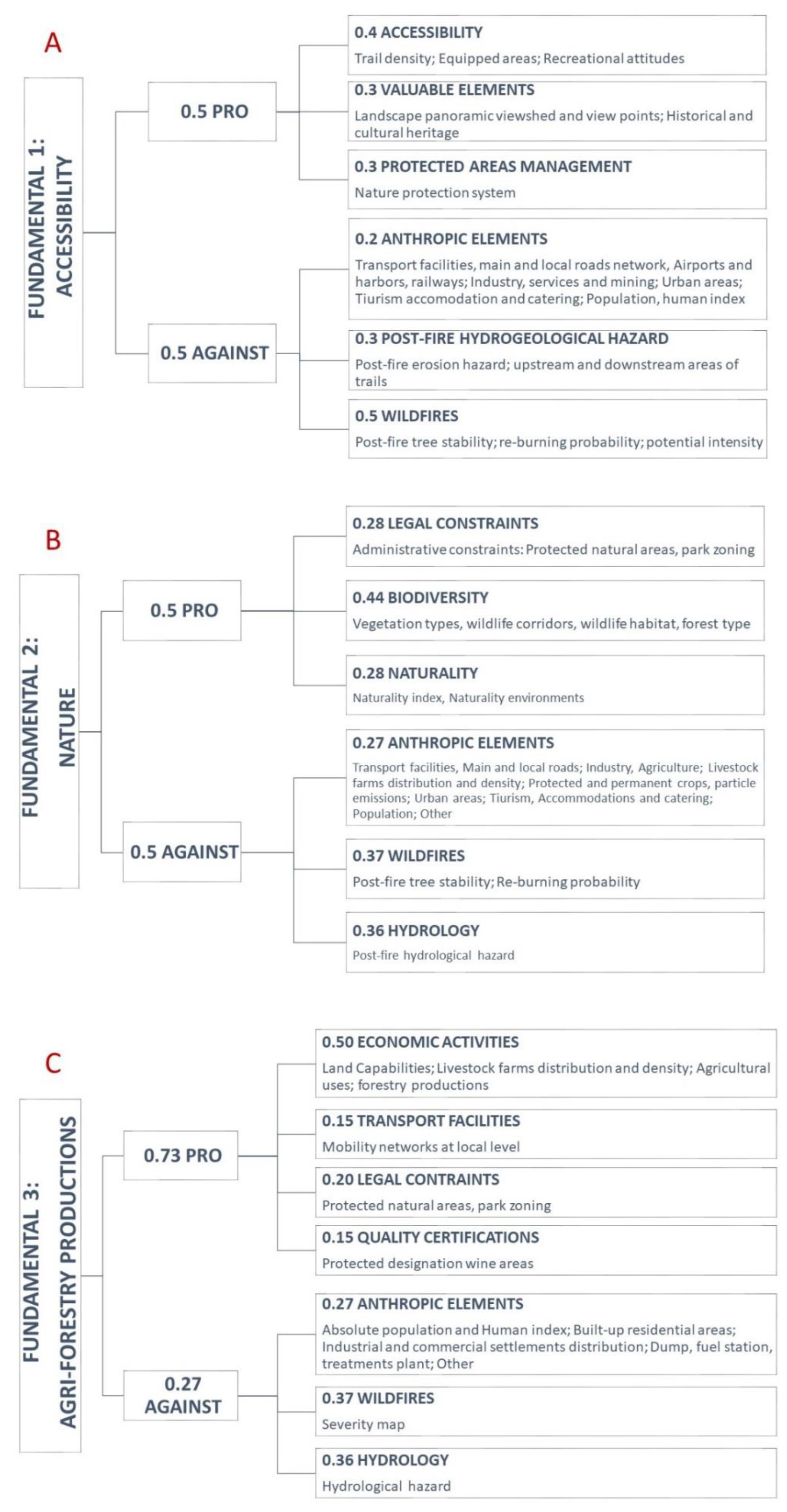
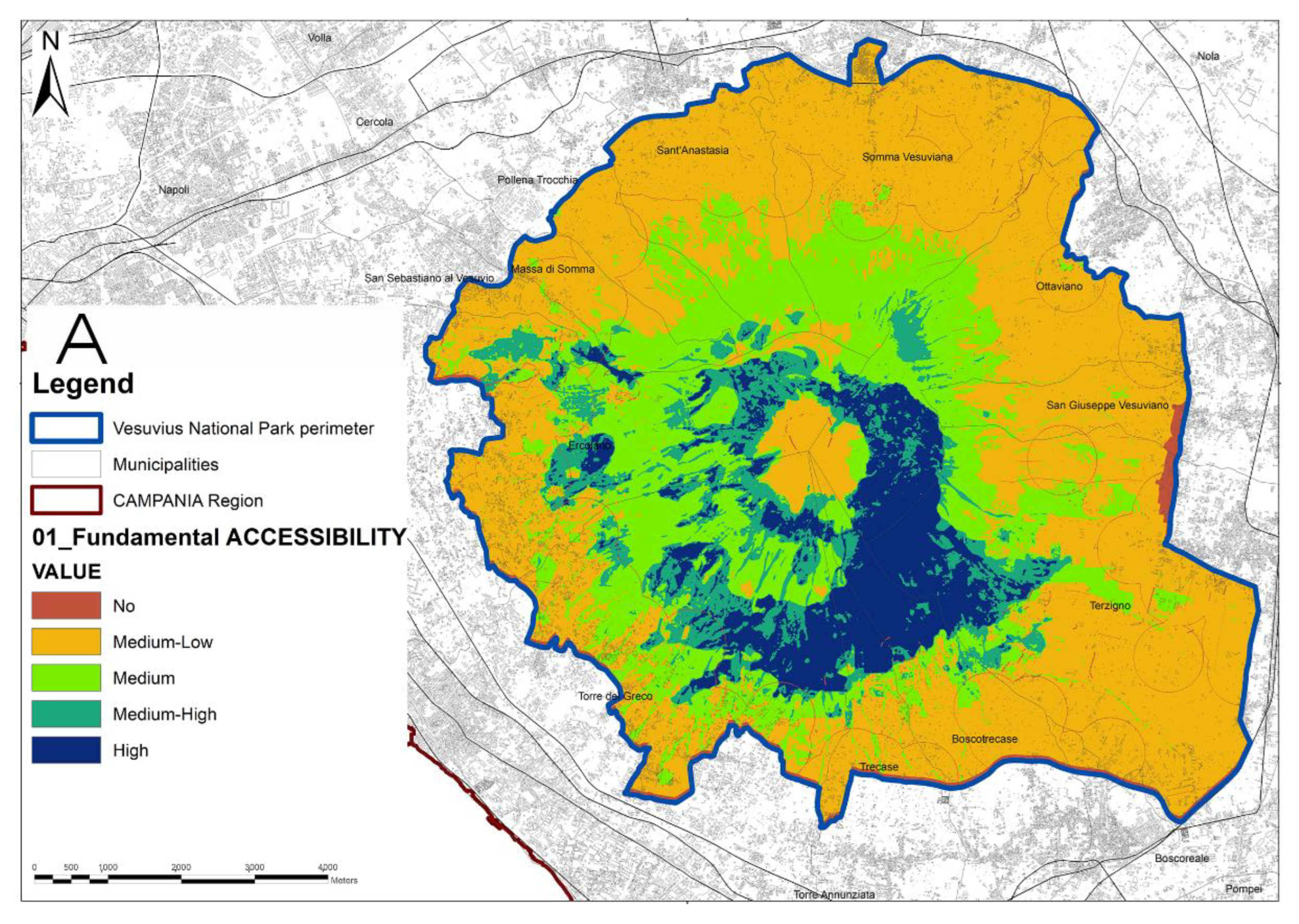

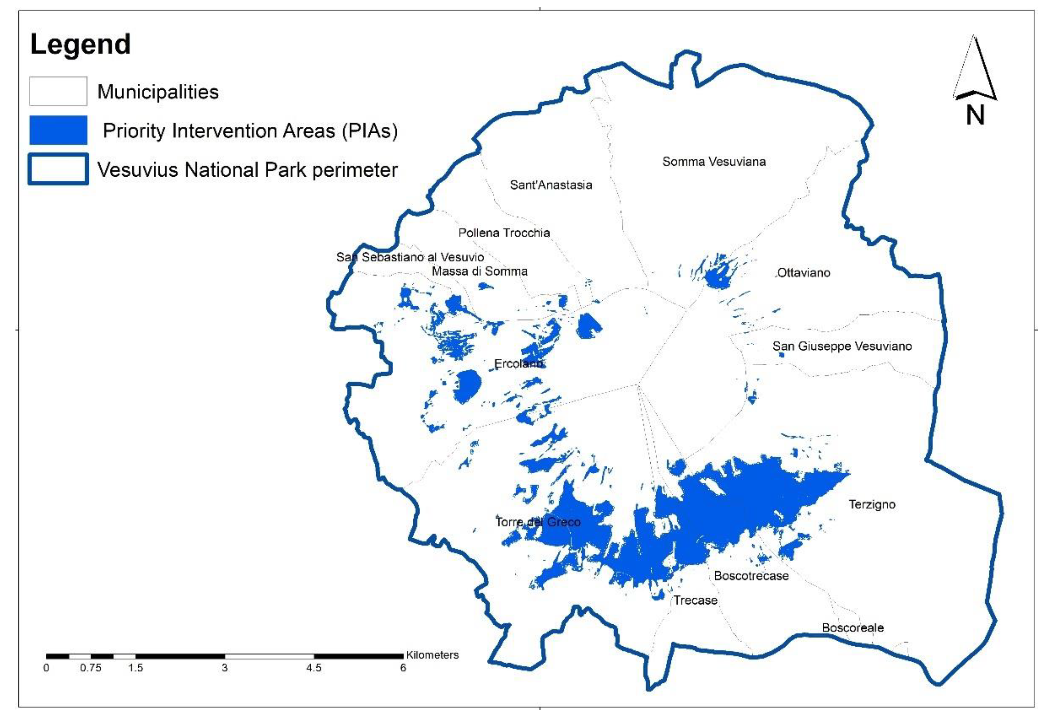

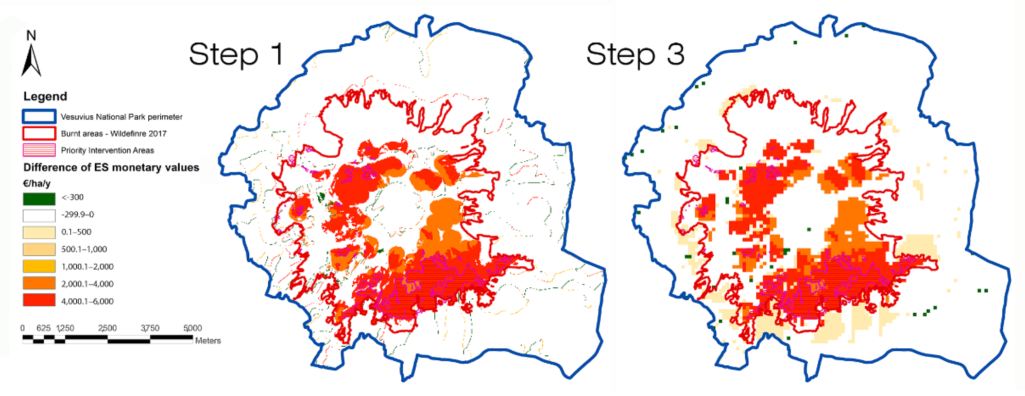
Publisher’s Note: MDPI stays neutral with regard to jurisdictional claims in published maps and institutional affiliations. |
© 2022 by the authors. Licensee MDPI, Basel, Switzerland. This article is an open access article distributed under the terms and conditions of the Creative Commons Attribution (CC BY) license (https://creativecommons.org/licenses/by/4.0/).