Article

Curonian Spit Coastal Dunes Landscape: Climate Driven Change Calls for the Management Optimization

by
Rasa Šimanauskienė
1,2,*,
Rita Linkevičienė
1,2,
Ramūnas Povilanskas
3,
Jonas Satkūnas
1,
Darijus Veteikis
2,
Aldona Baubinienė
1 and
Julius Taminskas
1
1
Nature Research Centre, Akademijos Street 2, LT-08412 Vilnius, Lithuania
2
Faculty of Chemistry and Geosciences, Institute of Geosciences, Vilnius University, Čiurlionio Street 21/27, LT-03101 Vilnius, Lithuania
3
Department of Sport, Recreation and Tourism, Faculty of Health Sciences, Klaipėda University, Herkaus Manto Street, LT-92294 Klaipėda, Lithuania
*
Author to whom correspondence should be addressed.
Land 2022, 11(6), 877; https://doi.org/10.3390/land11060877
Submission received: 16 May 2022 / Revised: 6 June 2022 / Accepted: 7 June 2022 / Published: 9 June 2022

Abstract

:
On the Curonian Spit, the leading conservation issue is an opposition between the two contrasting nature-management principles—anthropocentricity and biocentricity. Land managers still waver between the two options, and the worst-case scenario materializes as a rapid proliferation of vegetation to the accumulative sandplain (palve). It results in the decline of sand drift to the mobile dunes. This article aims to examine how climate change affects the coastal dune landscape and to identify current dune protection and management priorities. The analysis of hydroclimatic changes; succession patterns in forest, herbaceous, and open-sand ecosystems; and phenological-based evaluation (NDVI from MODIS, 2000–2020), influencing possible management directions, were carried out in this study. The results show the significant hydro-climatic changes (air temperature, precipitation, and sea level) occurring over the last thirty years. They influence the prevailing overgrowth trends in recent decades, especially in herbaceous ecosystems. Therefore, if the EU’s priority habitat—open-sand ecosystems—is to be preserved, the main policy recommendation is to apply adequate management tools such as grazing, and to pay more attention to the aesthetic ecosystem services of the mobile dunes parallel to biodiversity conservation.

1. Introduction

The landscape protection and management of the coastal dunes of the Curonian Spit are based on the paradigm developed during the 20th century. The main concept of it is the unique coastal landscapes formed during the Anthropocene. They are not stable due to sandstorms and high anthropogenic pressures. Meanwhile, climate change is paving the way for new challenges in the coastal dune landscape and requires a new discussion of priorities for the protection and management of the dune landscape.
Dynamic systems of dunes are often subject to landscape and ecological changes. Several factors of physical, biological, and anthropogenic natures [1,2,3] influence their spatial and temporal evolution, which can be well-captured by remote-sensing techniques [4,5,6,7]. Vegetation cover changes in these transitional zones between terrestrial and marine environments are well-reflected by the widely used normalized difference vegetation index (NDVI). NDVI images, being a good proxy of canopy biomass [8] and showing the health of vegetation [9] are often used to monitor vegetation cover and its temporal pattern [10,11] as well as to inform management practices [2,12]. In the context of coastal dune ecosystems, the information provided by NDVI images is extremely useful, as the health status of the dune ecosystem is directly relevant to the wellbeing of the dune vegetation. It could serve as a very efficient tool to organize the adequate and timely management of these sensitive ecosystems [4].
Applications of remote-sensing techniques in the investigations of the Curonian Spit have been rather scarce [13]; however, the recent research [14,15,16] confirmed the significance of such investigations. Recently, satellite images for the territory of the Curonian Spit (Lithuanian and Russian parts) are used in three areas of research: the study of vegetation and land use changes [17,18,19], the study of NDVI dynamics [20], and the study of coastline dynamics [21]. Our research belongs to the second area of research, complements, and expands it. Therefore, the application of the results of ecosystem changes (according to NDVI) to the optimization of the management of the Curonian Spit is crucially important for the further development of the Curonian Spit landscape.
Aesthetic ecosystem services start playing an increasing role in coastal tourist destinations with a high leisure appeal [16]. However, these coastal destinations are under growing stress from climate change, urban sprawl, and resulting coastal squeeze. The Curonian Spit is a world-renowned destination, attracting over 1 million visitors annually. Throughout the 2010s, the authors of this study, with collaborators, have implemented a series of investigations on the Curonian Spit on different issues related to mobile dune dynamism and the aesthetic ecosystem services of dunes and forests [16,22,23,24,25,26,27,28].
Recently, we have applied a ‘quali–quantitative’ methodology, or mixed approach for the valuation of aesthetic ecosystem services of coastal dunes and forests on the Curonian Spit [27,28]. The main result of these surveys was that for lay domestic summer visitors, the most appealing were the following open landscapes of the Curonian Spit: 1. white mobile dunes; 2. white dunes with grey dunes in the background; 3. grey dunes with white dunes in the background.
The purpose of this article is to examine how climate change affects the coastal dune landscape and to identify current dune protection and management priorities. The studied territory includes the Lithuanian portion of the Curonian Spit. The work focuses on three main tasks: (a) to analyze the hydro-climatic conditions that may influence vegetation change in the area; (b) to study the overgrowth of the main habitats of the dune landscape; and (c) to discuss the directions for conservation and management of the changing dune landscape.

2. Materials and Methods
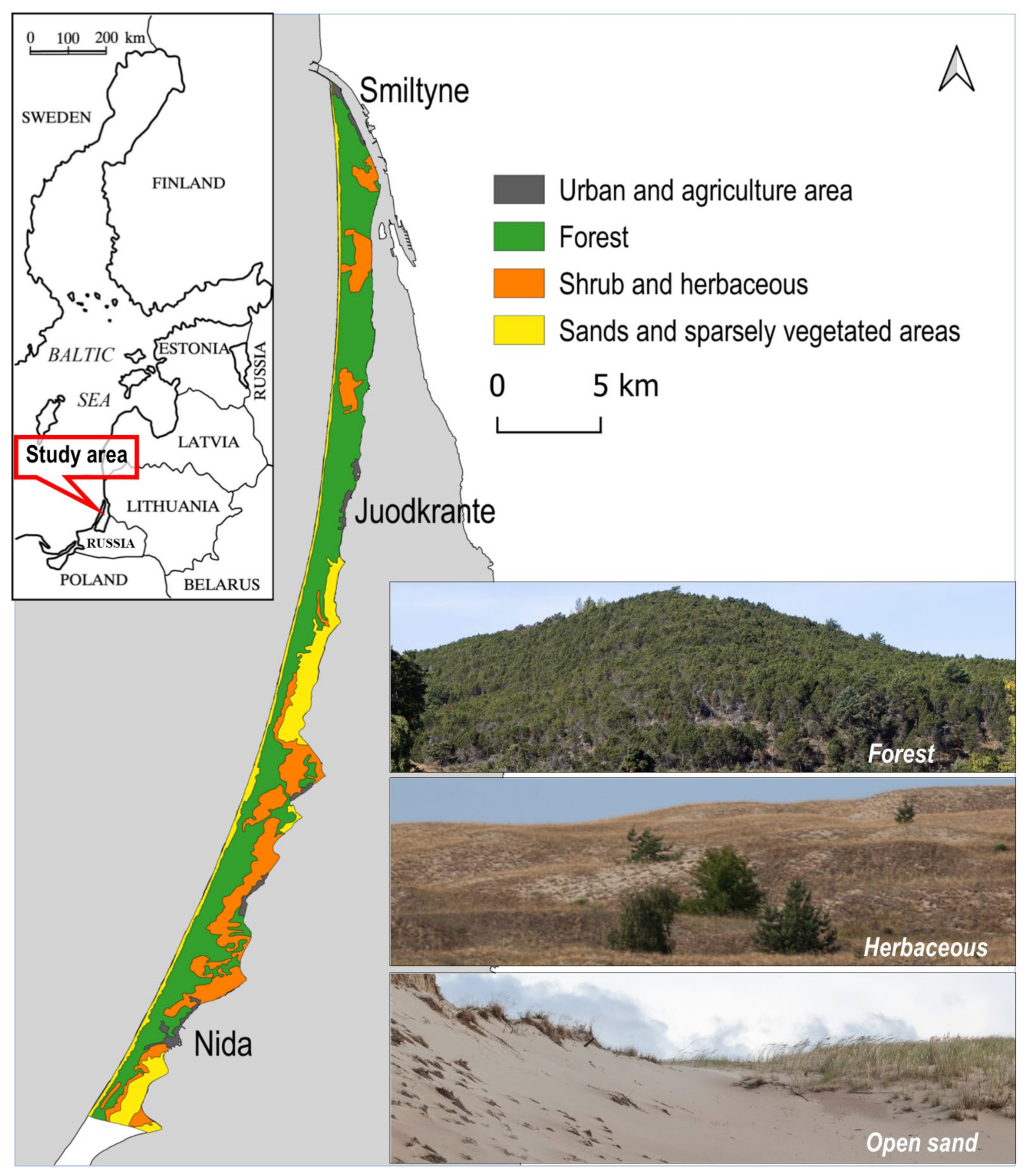
2.1. Study Area

The Curonian Spit, a narrow sandy barrier situated between the Baltic Sea and the Curonian Lagoon, is world-renowned as a mobile dunes landscape formed in the Holocene by the interplay of sand, wind, waves, vegetation, and human activity (Figure 1). It boasts a distinctive geomorphological feature—the 32.6-km long dune ridge (40 to 60 m a.s.l.), which is the most extended mobile dune chain in Europe [29,30,31,32]. Five strips of mobile dunes still remain on the Curonian Spit, 21.9 km being on the Russian part of the spit, and 10.7 km on the Lithuanian part [33]. The mobile dunes are protected within strict nature reserves of both Curonian Spit national parks—on the Russian part (established in 1987), and the Lithuanian part (established in 1991), both listed by UNESCO in 2000 as a transboundary World Heritage cultural landscape.
UNESCO has listed the Curonian Spit under criterion (v) as “an outstanding example of a landscape of dunes that is under constant threat from natural forces (wind and tide). After disastrous human interventions that menaced its survival, dune managers had reclaimed the Spit by massive protection and stabilization works that began in the 19th century and are continuing to the present day” [34]. However, even though the Great Dune Ridge of the Curonian Spit forms the unique natural feature of a European scale, the World Conservation Union (IUCN) did not consider that it met the very strict criteria to be UNESCO-listed as a nature World Heritage site [25].

2.2. Methods

In the Curonian Spit, changes in long-term air temperature, precipitation, wind speed, water level in the Baltic Sea and the Curonian Lagoon, and the depth of the Curonian Spit groundwater table were examined. The observational sequences of these indicators are very different. Some of them are very short or poor quality, or intermittent. As a result, dependable data analogs had to be used to fill or extend the monitoring data gaps.
The air temperature in the Curonian Spit (Nida WS) has been measured since 1947. The air temperature data series were extended by using Vilnius WS measurements. Air temperature measurements in Vilnius WS started in 1778. According to the average annual air temperature relationship of Nida and Vilnius WS in 1947–2020 the average annual air temperature in Nida (r = 0.965 p < 0.00001) was calculated for the period 1781–1946. Mean air temperature was also calculated for the summer and growing (May–September) seasons (r = 0.849 p < 0.00001). The periods of meteorological measurements were divided into 30-year sections when calculating the climatic norm (Table 1), and the average annual air temperature anomalies (deviation from the measurement period average) graph was created for the period of 1781–2018 in Nida.
Measurements of precipitation in Nida WS are available since 1947, in Vilnius WS—since 1887. However, the connection between the precipitation measured in Nida and Vilnius WS is statistically insignificant in some months (p > 0.05). Therefore, measurements of Klaipėda WS precipitation data were used for the period extension. Precipitation measurements in Klaipėda WS have been recorded since 1924. The link between the monthly precipitation of Nida and Klaipėda WS varies from 0.683 to 0.920 (p < 0.00001). The same as for the average temperature, the precipitation norms of the annual, summer, and growing seasons were calculated for 30-year periods (Table 1) and the annual precipitation anomalies (deviation from the measurement period average) graph was created based on the calculations of the 1924–1946 period and the measurements of the 1947–2018 period.
Determining the change in wind speed based on Nida WS or Klaipėda WS measurements raises concerns due to changes in equipment and measurement methods. Therefore, to correctly evaluate long-term wind-speed changes, the data of wind speeds were obtained from the KNMI Climate Explorer web application ERA-Interim reanalysis to 1979 (https://climexp.knmi.nl/selectfield_rea.cgi?id=someone@somewhere, accessed on 15 May 2022). Due to the lack of data, we were only able to calculate climatic norms for wind speed for two 21-year periods (Table 1).
The Baltic Sea water-level measurements (Klaipeda GS) range from 1898 to 2019, with a gap between 1941 and 1948. The average annual sea-water level during the period of 1941–1948 was calculated using the linear relationship of the measured water level from 1930 to 1940 and 1949 to 1952 (r = 0.982; p < 0.00001). The water-level measurements of the Curonian Lagoon (Nida GS) started in 1948. For two 30-year periods, these lagoon water level data were used to calculate the norms of the summer and growing seasons, and the annual water level of the Curonian Lagoon.
The depth of groundwater in the Curonian Spit has been measured since 1961. The water depth used in this study was measured in Juodkrante (55°32′27″ N; 21°07′19″ E). Missing data from 2005 to 2010 were calculated using the linear relationship (r = 0.878; p < 0.00001) between the average monthly water table in Nida (55°18′7″ N; 21°0′23″ E) and Juodkrante wells.
The main analysis about succession patterns in forest, herbaceous, and open-sand ecosystems (except territories affected by fires in 2006 and 2014) were carried out in this study. According to the orthophotos of 1995, 2005, 2013, and 2017 homogeneous vegetation tiles (250–250 m) representing each ecosystem type were distinguished: 20 tiles for forest, 9 for herbaceous, and 6 tiles for open-sand ecosystems. Each tile was adjusted according to MODIS (Moderate Resolution Imaging Spectroradiometer) product pixels (250 × 250 m).
Phenological-based evaluation of these ecosystems succession trends were done according to the commonly used normalized difference vegetation index (NDVI), which is widely applied for the estimation of the responses of vegetation towards changes in hydroclimatic conditions [35]. Furthermore, it greatly compensates for differences in sun illumination, aspect, slope, and other variations in topography [9] which could be beneficial in coastal dunes ecosystems research.
The NDVI data layers were generated from NIR and RED bands of MODIS images in ERDAS Imagine software and are defined as: NDVI = (NIR − RED)/(NIR + RED). NIR represents the spectral reflectance in the near infrared band (841–876 nm from MODIS), while RED represents the red band (620–670 nm from MODIS). This equation produces an index value that ranges from −1 (for nonvegetation classes—water, snow, built-up areas, and barren land) to +1 (for different types of vegetation classes) [35,36]. The calculation of average, minimum, and maximum NDVI values for the three surface classes (forest, herbaceous, and sands) from NDVI rasters were carried out in ArcGIS Desktop 10.7.1 software.
The eight-day MODIS composites (MOD09Q1) of surface reflectance (NIR and RED) with a spatial resolution of 250 m for twenty-one years (2000–2020) were obtained from NASA’s LAADS–DAAC (https://ladsweb.modaps.eosdis.nasa.gov, accessed on 15 May 2022). Cloud-free images of the growing season in Lithuania (May–September, with an average day temperature >10 °C) were used for evaluation of phenological behavior in all three ecosystems.
Nonparametric Mann–Kendall and Sen’s slope trend tests using Real Statistics Resource Pack XREALSTATS software were performed to detect the statistical significance and magnitude of the studied trends.

3. Results

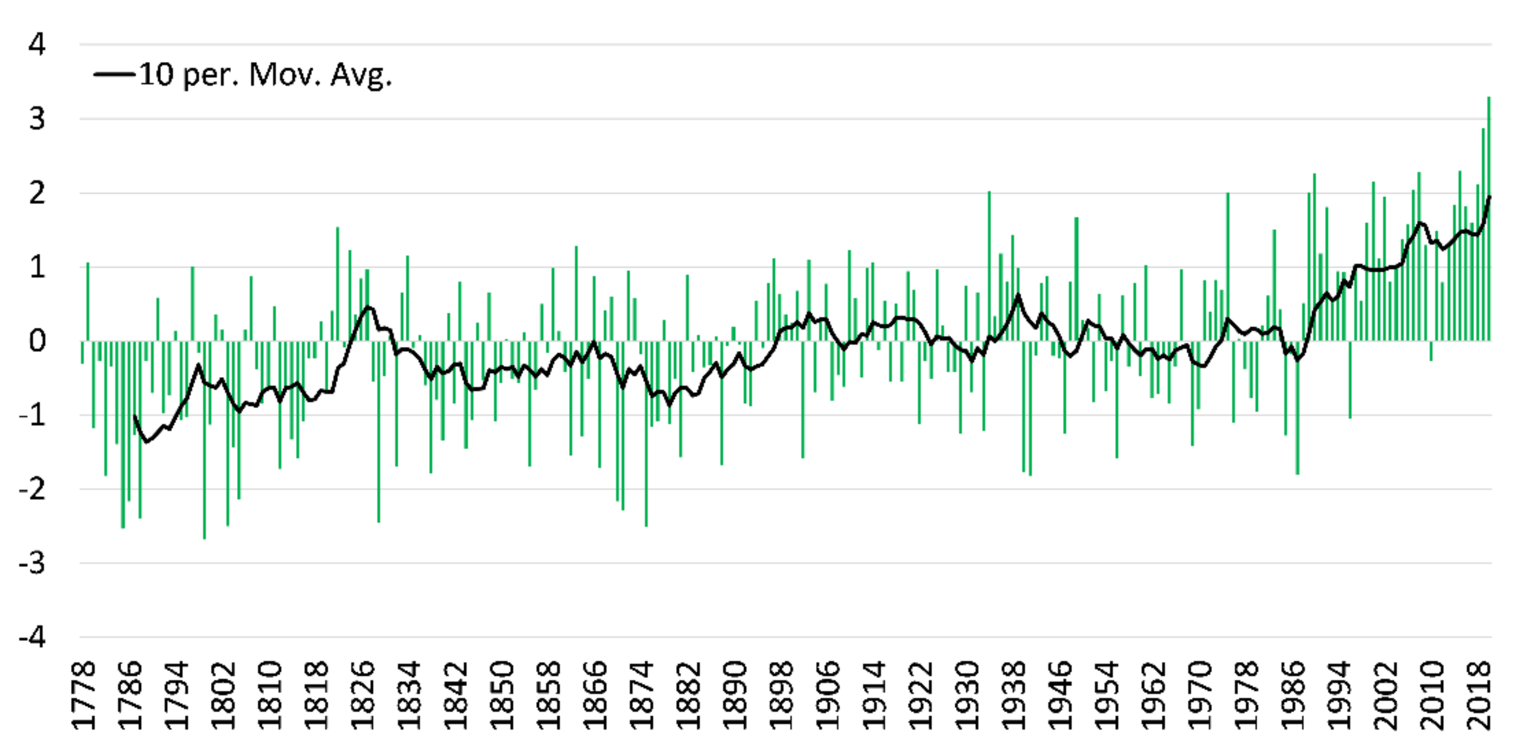
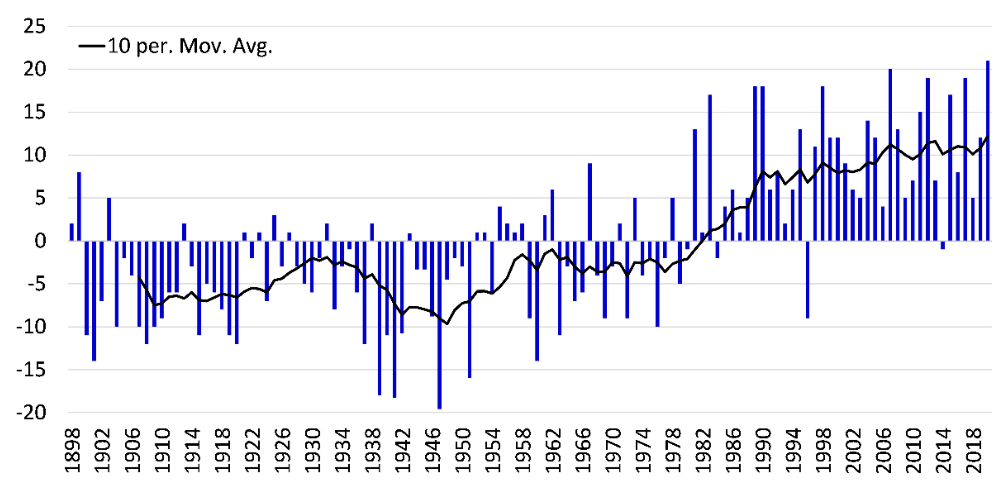
3.1. Hydro-Climatic Changes

Since the beginning of the 19th century the weather warming is observed. The average annual air temperature rate increases by 0.6 °C, while the average summer (0.30 °C) and growing season (0.2 °C) air temperature rates increase less (Table 1, Figure 2). Later, for 180 years, from the beginning of the 19th to the last decade of the 20th century, the average annual air temperature in the Curonian Spit increased by another 0.4 °C. This increase in air temperature was related to the warming of the cold season, as the air temperature rate during the growing season remained almost unchanged. The highest weather warming was observed in the last 30 years (Figure 2). Compared to 1961–1990, the average annual and growing-season temperature norms increased by 1.2 °C, and in the summer season by as much as 1.3 °C (Table 1).
The average annual and growing season precipitation climatic norms in 1961–1990 increased by 10% compared to the period 1931–1960 (Table 1). The annual precipitation climatic norm increased by 12% (82 mm) between 1991 and 2000, but the growing season rate increased by only 4% (12 mm). Winter precipitation has increased significantly over the last 30 years (33%). Meanwhile, the winter precipitation climatic norm increased by only 2% in 1961–1990 compared to 1931–1960. Since the 1990s, there has been the greatest increase in annual precipitation (Figure 3).
The average annual wind speed decreased by 0.2 m s−1 2000–2020 when compared to 1979–1999. During the growing season, the average wind speed decreased slightly less (Table 1). It should be noted that the downward trend in wind speed was observed globally [37].
The average annual Baltic Sea level increased by 14 cm from the beginning until the third decade of the 20th century (Table 1). The most significant rise in the level of the Baltic Sea began in the 1980s (Table 1, Figure 4). During this time, sea levels increased at a rate of about 0.17 cm per year, whereas it was nearly twice as slow at the beginning of the century. The water level in the Baltic Sea decreased by about 0.16 cm per year in the middle of the 20th century (1930–1950). (Figure 4).
By the mid-1980s, the Curonian Lagoon’s average annual water level was declining by about 0.15 cm per year. The largest increase in the water level of the Curonian Lagoon was observed in the 1980s and the first decade of the 21st century. During the first decade of this century, the average annual increase of the Curonian Lagoon level was about 1.12 cm per year. The average annual level of the Curonian Lagoon decreased again in the second decade of this century. Despite these fluctuations, the average annual Curonian Lagoon level norm increased even in 8 cm. The average annual groundwater depth norm decreased by 2 cm in 1991–2020 compared to 1961–1990. Meanwhile, the depth norm during growing season remained constant, and the depth norm during the summer increased by 1 cm (Table 1).

3.2. NDVI Variation in Different Ecosystems

NDVI analysis in forest, herbaceous, and open-sand ecosystems was performed in the previous studies [16]. In our study statistical analysis was made according to updated data series for these ecosystems. The highest NDVI values were determined in forest ecosystems, while the biggest NDVI amplitude was found in herbaceous ecosystems. The open-sand ecosystem is characterized by the lowest NDVI values and the lowest amplitude during the whole growing season (Table 2).
Trends of ecosystem changes remained the same as in previous studies [16]: average NDVI values of the growing season increased in all ecosystem types and the most rapid increase appeared in herbaceous and open-sand ecosystems (Figure 5). The most obvious increase (according to Sen’s slope) is observed in September; statistically significant NDVI increase trends were detected also during other months of the growing season in herbaceous and open-sand ecosystems (Table 3). Sen’s slope values are much smaller in forest ecosystems and there were no trends detected during July–September according to the Mann–Kendall test.
In open-sand ecosystems, vegetation encroachment is also observed. However, when compared to herbaceous ecosystems, the NDVI trend in this ecosystem is lower. The forest ecosystem is distinguished by the lowest positive NDVI trend (Table 3), indicating that Mugo pine populations have matured and established a stable natural habitat. This habitat is regarded as a potential fire source, as evidenced by several fires over the last two decades (2006 and 2014).

3.3. Environment Management and Conservation of Coastal Dunes Landscape

Anfuso et al. [38] ascertains scenic valuation as an essential tool for protection and sustainable management of various coastal areas. In the case of the Curonian Spit, their findings validate the necessity for the preservation of white mobile dunes as a vital tourist choice parameter. Moreover, in the 1990s, dune experts have developed a new approach towards the evolution of dune landscapes, their role in maintaining the biological and landscape diversity, and their conservation regime appreciating the necessity to enhance dune mobility [39].
On the other hand, in landscape studies, we have to tackle a somewhat complex metamorphosis of attitudes and semantics of the landscapes with a convoluted history and salient societal connotations, e.g., those of Scots pine forest plantations with high leisure value on the Curonian Spit [24,25,26,27,28,32,40]. Although a single profile cannot define many coastal landscapes, their IUCN designations and management regimes tend to overlook this peculiarity and impose rigid rules and preservation frameworks regulating active outdoors and other human activities related to a single aspect—conservation [25].
The anthropocentric nature management paradigm prevalent until the mid-1990s interpreted wild nature or wilderness as the primary source of disorder that purposeful nature management measures must order. Meanwhile, according to Moore and McClaran p. 224 [41]: the pristine “wilderness has been increasingly ordered in terms of the emerging science of ecology. Whereas recreation and aesthetics initially framed discussions about wilderness, scientists and managers now speak of energy flows, gene pools, fire regimes, endangered species, and biological diversity.” Biocentrism, thus, may be interpreted as a rival and, conceivably, a substitute for anthropocentrism as the predominant nature management paradigm [32].
The inversion of the nature ordering and the resulting change in its management principles is apparent from the evolution of the dune management. Planting vegetation was the primary dune handling approach along the North Sea and the Baltic Sea coast throughout the 19th century and the better part of the 20th century [22]. These plantations in most places were, and, to a large extent, still are prudently cared for, preserved, and restored in the case of harm, e.g., from fire.
The dune-management approach is further changing with the advancement of dune ecology and a growing aesthetic interest from lay visitors in the mobile dune landscapes. Scientists value mobile dunes as diverse habitats and complex biotopes with prodigious significance for society [22]. However, anthropogenic interventions into the natural evolution of mobile dunes are aliens to the intrinsic order of nature.
As dynamic systems, mobile dunes are susceptible to impacts, and their natural ordering vulnerable. On the socio-economic side, the mobile dunes have many functions in modern society [42]: shoreline management; nature conservation; public drinking water extraction; recreation; housing and industry; agriculture; grazing; military defense. In addition, dunes serve as geoecological indicators [43] and desirable tourist destinations [24,25,26,27,28].
The Curonian Dune Ridge is the most outstanding landscape feature of the Curonian Spit. Along with the geomorphologic prominence, the white and grey dunes of the spit serve as pivotal NATURA 2000 habitats (Type 2120 and Type 2130, respectively). In addition, the dunes of the Curonian Spit offer breeding habitats for the Tawny Pipit (Anthus campestris) and open resting places for different migrating birds. The dunes serve as stepping stones along the Western Palearctic Flyway. They comprise a divergent ecotone between the aquatic and terrestrial environments characterized by moderate biodiversity.

4. Discussion

The most significant changes in air temperature in the Curonian Spit occurred between the outskirts of the 18th–19th and 20th–21st centuries. During these times, the air temperature increases noticeably. There were nearly 200 years between these two periods, during which the average annual air temperature increased only slightly. Substantial weather warming has occurred over the past 30 years. The annual average air temperature as well as the growing-season air temperature have increased. However, the most significant increase was observed in the average temperature norm of the summer—as much as 1.3 °C. Such a substantial increase in air temperature may have influenced plant succession.
In the last century, the annual, growing season, and summer precipitation rates have increased in the Curonian Spit. The largest increase in precipitation has been since the 1980s. When compared to the period 1931–1960, the annual precipitation norm has increased by nearly 23% and the summer precipitation norm by 21% over the last 30 years. Such a significant increase in precipitation also increased soil moisture reserves and facilitated faster sand dune growth [16].
Over the last 20 years, an increase in soil moisture has been accompanied by a decrease in wind speed. Due to the wind speed decrease the sand blowing became slower, creating ideal conditions for grassy vegetation implantation in the sand dunes. Rising water levels in the Baltic Sea and the Curonian Lagoon, on the other hand, increased the humidity of the coastal sand dunes while preventing the sand from blowing away. The rising level of the Baltic Sea and the Curonian Lagoon may also have had an impact on the rise of groundwater table along the sea and the lagoon’s shores. All this resulted in slower sand blowing and faster coastal sand dunes overgrowth.
Changes of hydro-meteorological indicators that may affect the vegetation of the Curonian Spit have been observed for more than 200 years. They were not, however, important for vegetation succession until the late 20th century. The Curonian Spit nature management and conservation paradigms had been established by the end of the 20th century. The most significant changes in hydro-climatic conditions, however, occurred only in the last thirty years, when the approach was already established and legal documents on nature use, and protection were created in the Curonian Spit. These significant changes in hydro-climatic conditions may have influenced the Curonian Spit’s landscape. As a result, the Curonian Spit’s nature use, and protection must be revised to account for the new hydro-climatic reality. The role of wild ungulates is well-represented in the Russian part of Curonian spit, therefore, if the EU’s priority habitat is to be preserved, management tools such as grazing should be considered in the Lithuanian part as well.
Our findings are consistent with the global trend of dune stabilization [44]. They are also compatible with the main trends identified in a few local and regional assessments of European coastal dune behavior—as vegetation cover has expanded, most European coastal dunes have gradually stabilized [37,45,46,47,48,49,50]. In the natural plan, both parts of the Curonian spit (Lithuanian and Russian) represent a single landscape; therefore, our research is also in line with the findings in the Russian part of the Curonian Spit, showing an increased percent of forest cover, and increased share of vegetation-fixed sands on the side the Curonian Lagoon because of forest-protection measures [18].
The results of interannual NDVI variation trends in our study show that vegetation is continuing to improve in all Curonian Spit ecosystems. However, in the older succession stages of the dune series, such as forest, this trend is less pronounced. In the forest ecosystem a stable vegetation condition was observed in July–August for the entire 21-year period, but at the beginning and the end of the growing season, a statistically significant increasing trend (p < 0.05) was reported in it. Simultaneously, a statistically significant increase in NDVI is observed throughout the growing season as well as in individual months in both open-sand and herbaceous ecosystems. As a result, overgrowth trends have prevailed in recent decades because of natural environmental changes, and they are related to succession in nonforested ecosystems.
For optimization of environment management and coastal dunes landscape protection, Porter and Salazar, p. 368 [51] noted that: “the power of commercial interests, governing bodies, or simply tradition challenge discussions of heritage and deny stakeholders a voice in the management of heritage spaces.” An essential inquiry is whether these issues in the Curonian Spit’s management may compromise the objectives of the UNESCO designation. After World War II, the reforestation of the Curonian Spit has sped up mobile dune fragmentation, overgrowth, and flattening [43]. The mobile dunes of the Curonian Spit were deprived of local sand supply sources and rapidly degraded as a result. The conservation paradigm on both the Lithuanian and Russian parts of the Curonian Spit now needed essential changes to meet differing stakeholders’ aspirations and different priorities in managing the mobile dunes and forest plantations, also relying on aesthetic appraisal [26].
So far, the national park managers aim to preserve the Curonian Spit prescriptively, emphasizing regulations and restrictions according to the principle that “everything is forbidden which is not explicitly allowed” p. 271 [26]. However, is the too-stringent (in our opinion) conservation approach essential to secure sustainable preservation of the mobile dunes, apart from in the most degraded strips? From the results, we may see that the essential issue in achieving the long-term stability of the mobile dune ridge on the Curonian Spit is to maintain the balance of its conservation and use. The rewilding concept aiming to promote beneficial interactions between society and nature could probably be useful in this aspect [52].
We argue that the current dune-handling approach on both sides of the border on the Curonian Spit is erroneous. For instance, the forest managers keep the number of moose very low, referring to the apparent fact that the moose eat saplings of Scots pine. However, if the managers care about preserving saplings of Scots pine, why then do they complain when the Scots pine proliferate into the accumulative plain (palve)? This means that the role of humans as agents facilitating the dynamism of mobile dunes should be enhanced, particularly because of the decline of grazing and in the face of increasing climate change.
Nowadays, the EU Habitat Directive supports the antisuccession management policy of fixed (grey) dunes with herbaceous vegetation. The Directive has classified herbaceous grey dunes as a priority NATURA 2000 habitat [16]. The removing of Mugo pine plantations and the introduction of grazing in the grey dunes is supported by the EU LIFE program, for example, by the Litcoast project (LIFE05 NAT/LT/000095). However, paradoxically, on the Curonian Spit, where large areas of mobile white dunes still exist, conservation of the herbaceous grey dunes as an EU priority habitat is not an antisuccessive measure, as anticipated, but, on the contrary, a successive one facilitating the expansion of herbaceous vegetation to mobile (white) dunes, which are much more unique on the European scale.
The description of the outstanding universal value of the Curonian Spit as a cultural World Heritage site further enhances the erroneous dune conservation policy. The description does not highlight the uniqueness of the mobile dunes, but on the contrary, emphasizes their long-gone menace to the population and the celebration of foresters’ toil to contain the sand drift, while appraising the efforts to continue these activities. In our opinion, such conservation policy should be reversed: the strictest conservation regime should be confined only to the mobile dune strips, whereas the accumulative plain at the windward (western) slope of the dunes should be turned into managed nature reserves.
The clue to the management sustainability of the mobile dunes lies in enhancing the dynamism of the accumulative plain where free access of tourists should be allowed [53] and any existing forest vegetation should be removed. Increasing moose stocks and bringing back herds of free-grazing domestic animals on the accumulative plain could restore the sand supply from the plain to the adjacent, leeward mobile dune strips. In this way, aesthetic, ecological, nature conservation and recreation development interests will be made more coherent on the Curonian Spit, particularly considering the most aesthetically appealing and salient forest and dune landscapes and habitats.

5. Conclusions

Until the end of the last century, the theoretical foundations of Curonian Spit nature management and protection were set, and they were focused on the existing hydro-climatic conditions. Significant hydro-climatic changes (to air temperature, precipitation, and sea level) have occurred in the last thirty years. It is especially reflected in the succession of herbaceous and open-sand ecosystems in the Curonian Spit. They generate the most recent climatic reality, which must be considered when optimizing the Curonian Spit’s management and nature protection provisions. Overgrowth trends have prevailed on the spit in recent decades because of natural environmental condition changes. They are primarily influenced by processes in nonforested ecosystems.
On the Curonian Spit, the leading conservation issue is an opposition between the two contrasting nature management principles—anthropocentric and biocentric ones. The managers still waver between the two options, and the worst scenario materializes as a rapid proliferation of vegetation to the accumulative sandplain (palve). It results in the decline of sand drift to the mobile dunes.
The Curonian Spit has a complex history and a solid necessity to resolve the latent conflict between nature conservation and tourism development. Therefore, a deeper understanding of the environmental changes would also help make better management decisions. For example, overgrazing has often resulted in disastrous secular sand drift in Northern Europe in modernity. However, the opposite extreme, i.e., complete eradication of grazing by animals or sand-trampling by visitors on the accumulative plain, leads to the proliferation of herbaceous vegetation into the still-existing mobile dune areas.
Considering the aesthetic ecosystem services of forest plantations and mobile dunes can also deliver valuable insight regarding the appropriateness of the conservation approaches on the Curonian Spit. Furthermore, it may help to strike a balance between mobile dune preservation and sustainable development of leisure and tourism. Therefore, the main policy recommendation is to pay more attention to the aesthetic ecosystem services of the mobile dunes parallel to biodiversity conservation.

Author Contributions

Conceptualization, J.T. and R.P.; methodology, software, R.Š., J.T.; validation, J.T., R.Š. and R.L.; formal analysis, R.L.; investigation, R.Š., J.T.; resources, J.S.; data curation, R.Š., J.S., D.V. and A.B.; writing—original draft preparation, J.T., R.Š., R.P.; writing—review and editing, R.P, D.V.; visualization, R.L.; supervision, R.Š. All authors have read and agreed to the published version of the manuscript.

Funding

This research received no external funding.

Data Availability Statement

Not applicable.

Acknowledgments

This study was supported by the Lithuanian Ministry of Education, Science and Sport, the programme: "An influence of the climatic and anthropogenic driven factors on the status of the ecosystems and their behavior, services provided and the sustainability of the resources” (20220419/V-585) The authors are grateful to the Lithuanian Hydrometeorological Service for providing hydro-meteorological data.

Conflicts of Interest

The authors declare no conflict of interest.

References

  1. Baas, A.C.W.; Nield, J.M. Modelling Vegetated Dune Landscapes. Geophys. Res. Lett. 2007, 34, L06405. [Google Scholar] [CrossRef]
  2. Barchyn, T.E.; Hugenholtz, C.H. Predicting Vegetation-Stabilized Dune Field Morphology. Geophys. Res. Lett. 2012, 39. [Google Scholar] [CrossRef] [Green Version]
  3. Romina, L.; Myakokina, O. Natural Features and Anthropogenic Factors of the Curonian Spit Ecosystem Formation. Life Earth 2021, 43, 248–257. [Google Scholar] [CrossRef]
  4. Valentini, E.; Taramelli, A.; Cappucci, S.; Filipponi, F.; Nguyen Xuan, A. Exploring the Dunes: The Correlations between Vegetation Cover Pattern and Morphology for Sediment Retention Assessment Using Airborne Multisensor Acquisition. Remote Sens. 2020, 12, 1229. [Google Scholar] [CrossRef] [Green Version]
  5. Sparavigna, A.C. Change Detection in Satellite Images Applied to the Study of Sand Dunes. HAL 2019. [Google Scholar] [CrossRef]
  6. Marzialetti, F.; Giulio, S.; Malavasi, M.; Sperandii, M.G.; Acosta, A.T.R.; Carranza, M.L. Capturing Coastal Dune Natural Vegetation Types Using a Phenology-Based Mapping Approach: The Potential of Sentinel-2. Remote Sens. 2019, 11, 1506. [Google Scholar] [CrossRef] [Green Version]
  7. Dogru, A.; Balcik, F.; Goksel, Ç.; Ulugtekin, N. Monitoring Coastal Dunes by Using Remote Sensing and GIS Integration in Northwest Turkey: A Case Study of Kilyos Dunes. Fresenius Environ. Bull. 2006, 15, 1216–1220. [Google Scholar]
  8. Campbell, J.B.; Wynne, R.H. Introduction to Remote Sensing, 5th ed.; The Guilford Press: New York, NY, USA, 2011; ISBN 978-1-60918-176-5. [Google Scholar]
  9. Lillesand, T.; Kiefer Ralph, W.; Chipman, J. Remote Sensing and Image Interpretation, 7th ed.; Wiley: Hoboken, NJ, USA, 2015; ISBN 978-1-118-34328-9. [Google Scholar]
  10. Huete, A.R. Vegetation Indices, Remote Sensing and Forest Monitoring: Vegetation Indices and Forest Monitoring. Geogr.y Compass 2012, 6, 513–532. [Google Scholar] [CrossRef]
  11. Vrieling, A.; Meroni, M.; Darvishzadeh, R.; Skidmore, A.K.; Wang, T.; Zurita-Milla, R.; Oosterbeek, K.; O’Connor, B.; Paganini, M. Vegetation Phenology from Sentinel-2 and Field Cameras for a Dutch Barrier Island. Remote Sens. Environ. 2018, 215, 517–529. [Google Scholar] [CrossRef]
  12. Xie, Y.; Sha, Z.; Yu, M. Remote Sensing Imagery in Vegetation Mapping: A Review. J. Plant Ecol. 2008, 1, 9–23. [Google Scholar] [CrossRef]
  13. Vaitkus, G.; Vaitkuvienė, D. Land Cover Changes in the Lithuanian Coastal Zone during 1975–2000. Acta Zool. Litu. 2005, 15, 183–187. [Google Scholar] [CrossRef]
  14. Galinienė, J. Change in Land Use and Land Cover of Coastal Zone: Classification Methods Comparison and Assessment. Ph.D. Thesis, Klaipėda University, Klaipėda, Lithuania, 2020. [Google Scholar]
  15. Mikėnas, J.; Pupienis, D. The Change of Rhythmic Patterns on the Sandy Baltic Sea Coasts. Vilnius Univ. Proc. 2020, 10, 40. [Google Scholar] [CrossRef]
  16. Taminskas, J.; Šimanauskienė, R.; Linkevičienė, R.; Volungevičius, J.; Slavinskienė, G.; Povilanskas, R.; Satkūnas, J. Impact of Hydro-Climatic Changes on Coastal Dunes Landscape According to Normalized Difference Vegetation Index (The Case Study of Curonian Spit). Water 2020, 12, 3234. [Google Scholar] [CrossRef]
  17. Galiniene, J.; Dailidiene, I.; Bishop, S.R. Forest Management and Sustainable Urban Development in the Curonian Spit. Eur. J. Remote Sens. 2019, 52, 42–57. [Google Scholar] [CrossRef] [Green Version]
  18. Center for Forest Ecology and Productivity of the RAS; Nikitina, A.D.; Knyazeva, S.V.; Gavrilyuk, E.A.; Tikhonova, E.V.; Eydlina, S.P.; Koroleva, N.V. Vegetation Cover Dynamics Mapping of the Curonian Spit National Park Using ALOS and SENTINEL-2 Satellite Imagery. FSI 2020, 3, 1–14. [Google Scholar] [CrossRef]
  19. Stont, Z.I.; Sergeev, A.Y.; Ulyanova, M.O. Dynamics of Dune Massifs in Various Meteorological Conditions on The Example of The Curonian Spit (South-Eastern Baltic Sea Coast). Geography Environ. Sustain. 2020, 13, 57–67. [Google Scholar]
  20. Jackson, D.W.T.; Costas, S.; González-Villanueva, R.; Cooper, A. A Global ‘Greening’ of Coastal Dunes: An Integrated Consequence of Climate Change? Glob. Planet. Chang. 2019, 182, 103026. [Google Scholar] [CrossRef]
  21. Bryksina, N.A. Study of the Dynamics of the Coastal Zone of the Baltic Sea Using Satellite Images. Geoinformatika 2013, 4, 65–72. [Google Scholar]
  22. Povilanskas, R.; Riepšas, E.; Armaitiene, A.; Dučinskas, K.T.; Taminskas, J. Shifting Dune Types of the Curonian Spit and Factors of Their Development. Balt. For. 2011, 17, 215–226. [Google Scholar]
  23. Povilanskas, R.; Armaitienė, A.; Breber, P.; Razinkovas-Baziukas, A.; Taminskas, J. Integrity of Linear Littoral Habitats of Lesina and Curonian Lagoons. Hydrobiologia 2012, 699, 99–110. [Google Scholar] [CrossRef]
  24. Povilanskas, R.; Armaitienė, A. Marketing of Coastal Barrier Spits as Liminal Spaces of Creativity. Proc. Soc. Behav. Sci. 2014, 148, 397–403. [Google Scholar] [CrossRef] [Green Version]
  25. Povilanskas, R.; Armaitienė, A.; Dyack, B.; Jurkus, E. Islands of Prescription and Islands of Negotiation. J. Destin. Mark. Manag. 2016, 5, 260–274. [Google Scholar] [CrossRef]
  26. Povilanskas, R.; Baziukė, D.; Dučinskas, K.; Urbis, A. Can Visitors Visually Distinguish Successive Coastal Landscapes? A Case Study from the Curonian Spit (Lithuania). Ocean Coast. Manag. 2016, 119, 109–118. [Google Scholar] [CrossRef]
  27. Urbis, A.; Povilanskas, R.; Šimanauskienė, R.; Taminskas, J. Key Aesthetic Appeal Concepts of Coastal Dunes and Forests on the Example of the Curonian Spit (Lithuania). Water 2019, 11, 1193. [Google Scholar] [CrossRef] [Green Version]
  28. Urbis, A.; Povilanskas, R.; Newton, A. Valuation of Aesthetic Ecosystem Services of Protected Coastal Dunes and Forests. Ocean Coast. Manag. 2019, 179, 104832. [Google Scholar] [CrossRef]
  29. Badyukova, E.N.; Zhindarev, L.A.; Luk’yanova, S.A.; Solov’eva, G.D. Geological Structure of the Curonian Spit (of the Baltic Sea) and Its Evolution History. Oceonology 2007, 47, 554–563. [Google Scholar] [CrossRef]
  30. Kharin, G.S.; Kharin, S.G. Geological Structure and Composition of the Curonian Spit (Baltic Sea). Lithol. Mineral Resour. 2006, 41, 317–323. [Google Scholar] [CrossRef]
  31. Zhukovskaya, I.P.; Kharin, G.S. The Curonian Spit Is a Geological Phenomenon. Samar. Luka Probl. Region. Glob. Ecol. 2009, 18, 60–69. [Google Scholar]
  32. Povilanskas, R. Landscape Management on the Curonian Spit: A Cross-Border Perspective; EUCC Publishers: Klaipėda, Lithuania, 2004. [Google Scholar]
  33. Povilanskas, R.; Satkūnas, J.; Taminskas, J. Results of Cartometric Investigations of Dune Morphodynamics on the Curonian Spit. Geologija 2006, 53, 22–27. [Google Scholar]
  34. Curonian Spit, Unesco. Available online: http://whc.unesco.org/en/list/994 (accessed on 13 May 2022).
  35. Pinto, L.H.T.; Fernandes, L.d.R. Multitemporal Analyses of the Vegetation Cover of Coastal Sand Dune Ecosystems in Natal/RN, Based on NDVI Index. In Proceedings of the Anais XV Simpósio Brasileiro de Sensoriamento Remoto - SBSR, Curitiba, Brazil, 30 April–5 May 2011; pp. 1895–1901. [Google Scholar]
  36. Yacouba, D.; Guangdao, H.; Xingping, W. Assessment Of Land Use Cover Changes Using Ndvi And Dem In Puer And Simao Counties, Yunnan Province, China. World Rural Observ. 2009, 1, 1–11. [Google Scholar]
  37. McVicar, T.R.; Roderick, M.L.; Donohue, R.J.; Li, L.T.; Van Niel, T.G.; Thomas, A.; Grieser, J.; Jhajharia, D.; Himri, Y.; Mahowald, N.M.; et al. Global Review and Synthesis of Trends in Observed Terrestrial Near-Surface Wind Speeds: Implications for Evaporation. J. Hydrol. 2012, 416, 182–205. [Google Scholar] [CrossRef]
  38. Anfuso, G.; Williams, A.T.; Cabrera Hernández, J.A.; Pranzini, E. Coastal Scenic Assessment and Tourism Management in Western Cuba. Tourism Manag. 2014, 42, 307–320. [Google Scholar] [CrossRef]
  39. Doody, J.P. Sand Dune Conservation, Management and Restoration; Coastal Research Library; Springer Netherlands: Dordrecht, The Netherlands, 2013; Volume 4, ISBN 978-94-007-4730-2. [Google Scholar]
  40. Armaitienė, A.; Boldyrev, V.L.; Povilanskas, R.; Taminskas, J. Integrated Shoreline Management and Tourism Development on the Cross-Border World Heritage Site: A Case Study from the Curonian Spit (Lithuania/Russia). J. Coast. Conserv. 2007, 11, 13–22. [Google Scholar] [CrossRef]
  41. Moore, S.D.; McClaran, M.P. Symbolic Dimensions of the Packstock Debate. Leisure Sci. 1991, 13, 221–237. [Google Scholar] [CrossRef]
  42. Jungerius, P.D. Dune Development and Management, Geomorphological and Soil Processes, Responses to Sea Level Rise and Climate Change. Baltica 2008, 21, 13–23. [Google Scholar]
  43. Povilanskas, R. Spatial Diversity of Modern Geomorphological Processes on a Holocene Dune Ridge on the Curonian Spit in the South-East Baltic. Baltica 2009, 22, 77–88. [Google Scholar]
  44. Chen, M.; Parton, W.J.; Hartman, M.D.; Del Grosso, S.J.; Smith, W.K.; Knapp, A.K.; Lutz, S.; Derner, J.D.; Tucker, C.J.; Ojima, D.S.; et al. Assessing Precipitation, Evapotranspiration, and NDVI as Controls of U.S. Great Plains Plant Production. Ecosphere 2019, 10. [Google Scholar] [CrossRef]
  45. Baumbach, L.; Siegmund, J.F.; Mittermeier, M.; Donner, R.V. Impacts of Temperature Extremes on European Vegetation during the Growing Season. Biogeosciences 2017, 14, 4891–4903. [Google Scholar] [CrossRef] [Green Version]
  46. Kim, J.Y.; Rastogi, G.; Do, Y.; Kim, D.K.; Muduli, P.R.; Samal, R.N.; Pattnaik, A.K.; Joo, G.J. Trends in a Satellite-Derived Vegetation Index and Environmental Variables in a Restored Brackish Lagoon. Global Ecol. Conserv. 2015, 4, 614–624. [Google Scholar] [CrossRef] [Green Version]
  47. Groeneveld, D.P. Remotely-Sensed Groundwater Evapotranspiration from Alkali Scrub Affected by Declining Water Table. J. Hydrol. 2008, 358, 294–303. [Google Scholar] [CrossRef]
  48. Piao, S.; Fang, J.; Liu, H.; Zhu, B. NDVI-Indicated Decline in Desertification in China in the Past Two Decades. Geophys. Res. Lett. 2005, 32, 1–4. [Google Scholar] [CrossRef]
  49. Wang, J.; Rich, P.M.; Price, K.P. Temporal Responses of NDVI to Precipitation and Temperature in the Central Great Plains, USA. Int. J. Remote Sens. 2003, 24, 2345–2364. [Google Scholar] [CrossRef]
  50. Yang, H.; Yang, X.; Heskel, M.; Sun, S.; Tang, J. Seasonal Variations of Leaf and Canopy Properties Tracked by Ground-Based NDVI Imagery in a Temperate Forest. Sci. Rep. 2017, 7, 1–10. [Google Scholar] [CrossRef] [PubMed]
  51. Porter, B.W.; Salazar, N.B. Heritage Tourism, Conflict, and the Public Interest: An Introduction. Int. J. Heritage Stud. 2005, 11, 361–370. [Google Scholar] [CrossRef] [Green Version]
  52. Perino, A.; Pereira, H.M.; Navarro, L.M.; Fernández, N.; Bullock, J.M.; Ceaușu, S.; Cortés-Avizanda, A.; van Klink, R.; Kuemmerle, T.; Lomba, A.; et al. Rewilding Complex Ecosystems. Science 2019, 364, eaav5570. [Google Scholar] [CrossRef] [Green Version]
  53. Anokhin, A.Y.; Kropinova, E.G.; Eduardas, S. Development of Geotourism Based on the Use of Geo-Heritage (on the Example of the Curonian Spit-UNESCO Site). Baltic Region 2021, 13, 112–128. [Google Scholar] [CrossRef]
Figure 1. The location of the Curonian Spit and its three ecosystem types: forest, herbaceous, and sand.
Land 11 00877 g001
Figure 2. Anomalies of calculated (1781–1946) and observed (1947–2020) average annual temperature in Nida, °C.
Land 11 00877 g002
Figure 3. Anomalies of calculated (1924–1946) and observed (1947–2020) annual precipitation in Nida, mm.
Land 11 00877 g003
Figure 4. Anomalies of average annual Baltic Sea level in Klaipėda, cm.
Land 11 00877 g004
Figure 5. Average annual NDVI in forest, herbaceous, and open-sand ecosystems of the Curonian Spit during the growing seasons from 2000 to 2020.
Land 11 00877 g005
Table 1. Hydro-climatic norms in the Curonian Spit.
PeriodTemperature, °CPrecipitation, mmWind Speed, m s−1 *
SummerMay–SeptemberYearSummerMay—SeptemberYearSummerMay–SeptemberYear
1781–181016.414.86.2------
1811–184016.715.06.8------
1841–187016.915.16.8------
1871–190016.715.06.8------
1901–193016.514.97.1------
1931–196016.915.27.2183301624---
1961–199016.614.97.22083306904.85.05.8
1991–202017.916.18.42223427724.84.95.6
Water level, cm
Baltic SeaCuronian lagoonGroundwater table, ASL
SummerMay–Sept.YearSummerMay–Sept.YearSummerMay–Sept.Year
1901–1930--−5------
1931–1960--−3------
1961–1990001449232533
1991–2020879131217242531
* Wind speed 1979–2020: 1979–1999, 2000–2020.
Table 2. NDVI values in different ecosystems of the Curonian Spit, May–September 2000–2020.
ForestHerbaceousOpen Sand
Average0.8080.5600.269
Average maximum0.8680.6460.329
Average minimum0.6920.4510.211
Average amplitude0.1770.1950.118
Table 3. Sen’s slope values, NDVI monthly averages 2000–2020.
MayJuneJulyAugustSeptemberGrowing Season
Forest0.0024 **0.0030 **−0.0006 *0.0008 *0.0020 *0.0015 **
Herbaceous0.0075 ***0.0058 ***0.0061 ***0.0071 ***0.0088 ***0.0069 ***
Open sand0.0044 ***0.0040 ***0.0043 ***0.0042 ***0.0054 ***0.0041 ***
* no trend; ** p < 0.05; *** p < 0.001.
Publisher’s Note: MDPI stays neutral with regard to jurisdictional claims in published maps and institutional affiliations.

