Review

Geo-Environmental Characterisation of High Contaminated Coastal Sites: The Analysis of Past Experiences in Taranto (Southern Italy) as a Key for Defining Operational Guidelines

by
Angela Rizzo
1,2,
Francesco De Giosa
3,
Antonella Di Leo
4,
Stefania Lisco
1,2,
Massimo Moretti
1,2,
Giovanni Scardino
1,2,*,
Giovanni Scicchitano
1,2 and
Giuseppe Mastronuzzi
1,2
1
Department of Earth and Geoenvironmental Sciences, Campus Universitario, University of Bari Aldo Moro, via E. Orabona, 4, 70125 Bari, Italy
2
Interdepartmental Research Centre for Coastal Dynamics, Campus Universitario, University of Bari Aldo Moro, via E. Orabona, 4, 70125 Bari, Italy
3
Environmental Surveys s.r.l., via Renato Dario Lupo, 65, 74121 Taranto, Italy
4
Istituto di Ricerca sulle Acque (IRSA) Consiglio Nazionale delle Ricerche, via Roma, 3, 74123 Taranto, Italy
*
Author to whom correspondence should be addressed.
Land 2022, 11(6), 878; https://doi.org/10.3390/land11060878
Submission received: 4 May 2022 / Revised: 2 June 2022 / Accepted: 6 June 2022 / Published: 9 June 2022
(This article belongs to the Special Issue Land Modifications and Impacts on Coastal Areas)

Abstract

:
Despite its remarkable geomorphological, ecological, and touristic value, the coastal sector of the Apulia region (Southern Italy) hosts three of the main contaminated Italian sites (Sites of National Interest, or SINs), for which urgent environmental remediation and reclamation actions are required. These sites are affected by intense coastal modification and diffuse environmental pollution due to the strong industrialisation and urbanisation processes that have been taking place since the second half of the XIX century. The Apulian coastal SINs, established by the National Law 426/1998 and delimited by the Ministerial Decree of 10 January 2000, include large coastal sectors and marine areas, which have been deeply investigated by the National Institution for the Environmental Research and Protection (ISPRA) and the Regional Agency for the Prevention and Protection of the Environment (ARPA) with the aim of obtaining a deep environmental characterisation of the marine matrices (sediments, water, and biota). More recently, high-resolution and multidisciplinary investigations focused on the geo-environmental characterisation of the coastal basins in the SIN Taranto site have been funded by the “Special Commissioner for the urgent measures of reclamation, environmental improvements, and redevelopment of Taranto”. In this review, we propose an overview of the investigations carried out in the Apulian SINs for the environmental characterisation of the marine matrices, with special reference to the sea bottom and sediments. Based on the experience gained in the previous characterisation activities, further research is aimed at defying a specific protocol of analysis for supporting the identification of priority actions for an effective and efficient geo-morphodynamic and environmental characterisation of the contaminated coastal areas, with special reference to geomorphological, sedimentological, and geo-dynamic features for which innovative and high-resolution investigations are required.

1. Introduction

The sustainable management of industrial and high-urbanised coasts is a significant issue globally. The U.S. Government Accounting Office [1] identified that approximately 60% of most contaminated sites are located along the coastal areas. Manzoor et al. [2] highlighted how the rapid economic development and industrialisation have caused an increase in metal concentrations in marine sediments in all the coastal regions of China. High concentrations of pollutants were also found in the Don River estuarine region [3]. Currently, only less than 1% of the Mediterranean coasts remain relatively unaffected by human activities [4] and almost 200 petrochemical plants and energy systems are located along the Mediterranean coastal sectors [5]. A similar condition is experienced in the northern European countries, whose relatively long coastlines are negatively influenced by anthropogenic activities [6]. In England, more than 1200 landfills are located in coastal areas [7], while in Italy, 77,733 ha of marine and coastal areas are included in the perimeters of the Sites of National Interest (SINs) that, according to the national legislation (Legislative Decree 152/2006 and subsequent amendments and additions), represent “a large portions of the national territory, which include all the different environmental matrices and entail a high health and ecological risk due to the density of the population or the extent of the site itself, as well as a significant socio-economic impact and a high risk to assets of historical and cultural interest.”
SINs management is entrusted to the Italian Ministry of Environment, Land and Sea (now Ministry for the Ecological Transition—MiTE), which uses the National Network System for Environmental Protection (SNPA, Rome, Italy) and the National Institute of Health (ISS, Rome, Italy), as well as other qualified public or private entities, for the technical investigation (Article 252-Legislative Decree 152/2006). The identification of the SINs and the definition of their boundaries started in 1998 in the frame of previous national regulations (MiTE, 2022—https://bonifichesiticontaminati.mite.gov.it/sin/istituzione-perimetrazione/, accessed on 3 May 2022 [8]). In 2012, 57 SINs were identified. With the entry into force of the Law 134/2012, which changed the criteria and parameters for the identification of SINs, the number of SINs decreased from 57 to 39. Then, a number of specific laws added further areas to the list. To date, the current number of SINs is 42 (Figure 1). With a total of 171,211 ha on land, SINs surface represents 0.57% of the Italian territory [9].
As shown in Table 1, the environmental status of the marine and coastal areas in SINs is deeply affected by the direct and indirect impacts of different anthropogenic activities, including industrial plants (chemical, petrochemical, metallurgical, steel, mechanical, pharmaceutical, cement, thermal), uncontrolled landfills, military arsenals, shipyards, and harbour areas with high maritime traffic. To include all the potentially contaminated coastal matrices in the SINs, the boundaries of the marine areas were defined by extending the perimeters up to 3 km from the coastline, as seaward limit of the potential impact of anthropogenic activities [10,11].
In order to obtain a comprehensive environmental characterisation and to define tailored reclamation projects for the risk reduction, between the years 2004 and 2014, the Italian Institute for the Environmental Research and Protection (ISPRA, Rome, Italy), commissioned by the Italian Ministry of Environment (now MiTE) in the framework of the National Programme for Land Reclamation and Environmental Restoration (Ministerial Decree 468/2001), carried out large-scale investigation plans aiming to define the concentration, distribution, and potential pathways of organic and inorganic pollutants. During these activities, particular attention was paid to the characterisation of marine sediments, since they represent the final sink for a wide variety of chemicals [12]. At the same time, several natural factors, such as bioturbation and resuspension by waves, storms, and tidal currents, and different anthropic activities (e.g., dredging, trawling, and navigation activities) may cause contaminants to become mobilised and released from sediments, which therefore play a fundamental role as a secondary source of pollution for the aquatic environment and marine fauna [13,14,15,16]. In addition, sediments represent the most suitable matrix for the assessment and monitoring of the marine environmental quality because the concentration of contaminants is less variable in time and space than in seawater [17]. A detailed description of the methodological approach applied by ISPRA to characterise the environmental status of the marine areas included in the SINs is shown in Ausili et al. [10]. The strategy was defined accounting for the main European legislation in force in the early 2000s.
Based on the distribution and related concentrations of contaminants, Ausili et al. [10] highlighted similarities among SINs where the same type of anthropogenic activities was established. In fact, SINs characterised by the presence of large iron and steel plants (SIN_17, SIN_09, SIN_13, SIN_21, and SIN_07) were mainly contaminated by metals (Cd, Pb, Zn, As, Cu, and Hg), PAHs, TPHs, and TBTs, which show an almost homogeneous distribution and higher concentrations in the sediments sampled close to the plants. Metals and TPHs resulted to be the main contaminants in the SINs were both industrial and petrochemical activities were carried out (SIN_06, SIN_03, SIN_36, SIN_02, and SIN_04). According to the results of this characterisation, the SINs numbered SIN_27, SIN_05, SIN_47, and SIN_34 showed a single source of pollution, being characterised by the presence of factories related to the production of Cr compounds (SIN_27), nitrogenous fertilisers (SIN_5), and mining activities (SIN_47 and SIN_34). Finally, for the SINs numbered SIN_44, SIN_48, and SIN_10, the concentrations of chemical pollutants were lower than in the other sites (the last two ones are currently excluded from the national lists). Furthermore, with Ministerial Decree n. 222 of 22 November 2021, the MiTE identified, on the proposal of the regions, the list of “orphan sites” to be reclaimed and which can be redeveloped thanks to the investments provided for in the National Recovery and Resilience Plan. As indicated by Ministerial Decree n. 269 of 29 December 2020, the “orphan site” represents a potentially contaminated area for which the person responsible for the pollution is not identifiable. In fact, the sites are abandoned industrial or mining areas, illegal landfills, former incinerators or refineries. These areas are often covered with waste, polluted by various toxic substances, which pose a threat to human health as well as have a strong environmental impact, in particular on soil, water and air.
The Apulian coastal (southern Italy) sector extends along the Adriatic and Ionian Sea for approximately 900 km, which corresponds to 12% of the Italian littorals. It is characterised by a remarkable scenic and environmental value due to the high geomorphological and ecological diversity [18,19,20]. Its coastal environments host species and habitats of great importance and protected at the international level, for the protection and safeguarding of which, three marine protected areas and a number of coastal sites included in the Natura 2000 framework have been established. The presence of numerous scenic coastal sites has turned the Apulian region into a highly attractive tourist destination [21], leading to an increasing tourism demand that contributes significantly to the regional economy, in terms of job activities, facilities development, and foreign exchange. In contrast to the high natural, ecological, and tourist importance, the Apulian coasts host three sites included in the SINs list, being characterised by a high environmental risk [22,23,24,25,26] and requiring priority importance for their complex reclamation. The Apulian coastal SINs (SIN_05 “Manfredonia”, SIN_06 “Brindisi”, and SIN_07 “Taranto”) were established by the National Law 426/1998 and delimited by the Ministerial Decree of 10 January 2000. They occupy a total land surface of 10,450 ha and 13,458 ha of sea surface. The marine-coastal and brackish areas included in the perimeters of the Apulian SINs were characterised following the standard procedure defined by ISPRA. The SIN in Taranto, due to the high environmental complexity that characterises its coastal sectors, has been object of further cognitive investigations promoted by the “Special Commissioner for the urgent measures of reclamation, environmental improvements, and redevelopment of Taranto” for gathering new insight into the origin, distribution, and mobility of the contaminants within the Taranto coastal basins (“Mar Piccolo” (Little Sea), and “Mar Grande”(Big Sea) basins). In particular, in a first phase (2013–2014), the Regional Environmental Agency (ARPA Puglia, Bari, Italy), in collaboration with different scientific partners, developed a technical-scientific program of activities aimed at deepening the knowledge of environmental status of the Mar Piccolo basin [22,23,25,26,27,28,29,30,31,32]. In the second phase (2015–2017), new multidisciplinary surveys were funded by the Special Commissioner with the aim of collecting data for the definition of geological, sedimentological, mineralogical, chemical, and geotechnical features of both coastal basins included in the SIN area [33,34,35,36,37,38,39]. Collected data support the understanding of the interactions between contaminants and environmental matrices, which are of paramount importance in the definition of the conceptual model of the site [37,40].
Starting from the analysis of experience gained in the previous characterisation activities, ongoing research actions are aimed at developing a protocol of integrated investigations for the definition of priority analyses to support the effective geo-environmental characterisation of contaminated coastal areas, for which innovative and high-resolution investigation methodologies are required. The suggested investigations will allow the geological model of the investigated site to be obtained, as well as its stratigraphic, sedimentological, and geochemical features. This set of information, integrated with chemical and geochemical analysis, will represent the scientific basis for defining the most suitable remediation and protection strategies for reducing health and environmental risks. The characterisation surveys are also needed to define tailored actions for monitoring the long-term effects after remediation operations. In addition, harmonised guidelines for the management of contaminated sites would be beneficial for exchange of knowledge between national administrators and the international community [6].

2. Overview of Reports Concerning the Characterisation of the Contaminated Sites in Italy
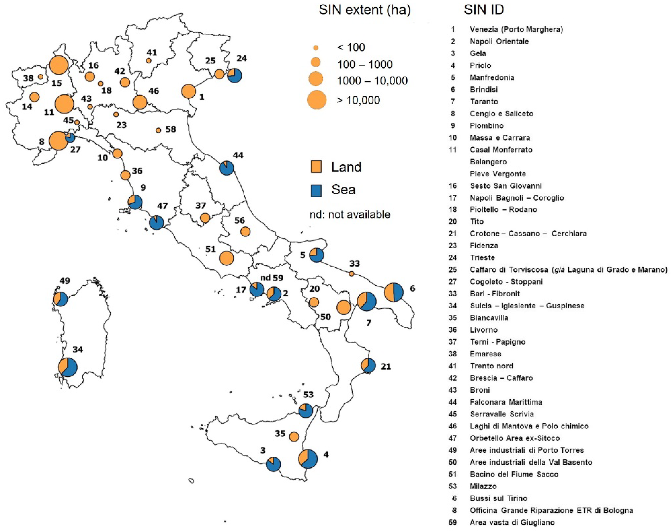
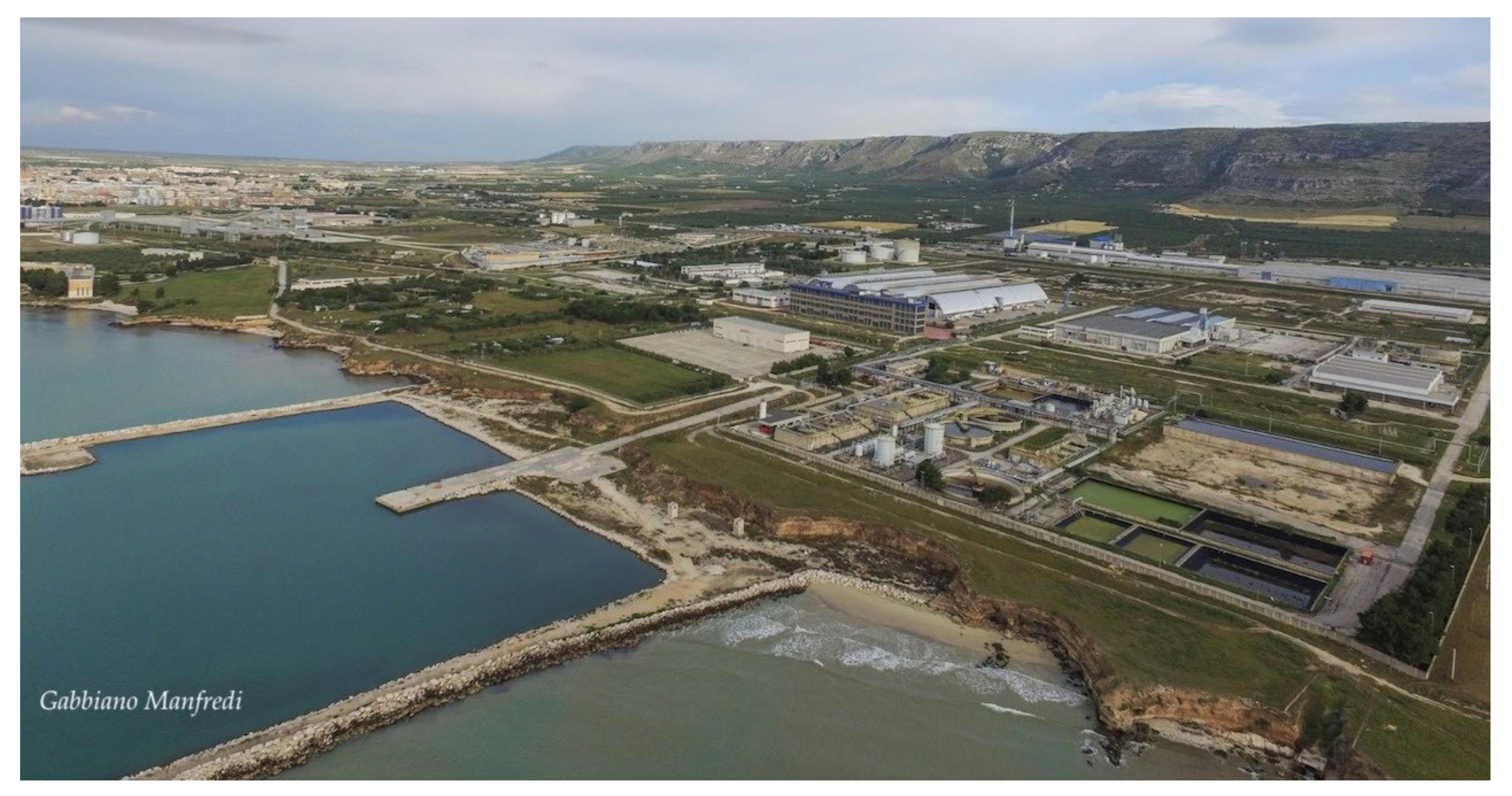
At the national level, ISPRA has made available a number of manuals and reports to support the preliminary characterisation of potentially contaminated sites, which is defined as “the set of activities that allow to reconstruct the contamination of environmental matrices, in order to obtain basic information on which to make decisions feasible and sustainable for the safety and/or remediation of the site itself” (Annex 2 to Title V, Part Four of Legislative Decree 152/2006). The report 146/2017 [41] defines tools to guide the elaboration of characterisation plan (art. 239 paragraph 3 of Legislative Decree 152/2006) relating to remediation and management of areas characterised by diffuse pollution whose management is committed to regional authorities. This document also provides a summary of the technical documentation available to support the chemical, microbiological and ecotoxicological characterisation of contaminated sites.
Report 146/2017 updated a previous manual [42] that for the first time has addressed the issues related to contaminated sites, paying particular attention to the investigations needed for the characterisation of soil, subsoil, and groundwater. In 2018, SNAP published a document to collect the experiences developed by the regional environmental agencies with regard to the methodological aspects and procedures for the determination of background values for pollutants present in soils and groundwater [43]. This report complements the information of previous documents published by other national and regional authorities with regard to the determination of background values in different environmental matrices, such as agricultural lands included in contaminated sites, groundwater, and underground water bodies. With regard to the technical procedures for handling marine sediments, a specific manual was published by APAT/ICRAM in 2007 [44] to summarise actions to address issues related to the handling of sediments in the marine-coastal environment with particular reference to harbour dredging, beach nourishment, and immersion in the sea of excavated material. On the basis of the re-organisation of the Italian legislation regulating the handling of sediments in SINs (Ministerial Decree 172/2016) and the immersion in the sea of excavation materials (Ministerial Decree 173/2016), ISPRA has published a technical manual [45] (ISPRA, Manuals and Guidelines 169/2017) to support the use of mathematical models for the prediction and assessment of environmental effects related to the transport of sediments during the handling activities. However, the document does not address the aspects related to the analysis of the effects of the mobilisation of contaminants that may be present in the handled sediments. Finally, in 2021, ISPRA released a report in which reliable, homogeneous, and comprehensive data on the management of contaminated sites are provided [46]. The collection, systematisation, and analysis of a common dataset on the administrative procedures relating to the contaminated sites allowed both the management progress and the state of environmental contamination to be adequately described. The results of this analysis show that the total number of contaminated sites is 34.478 (updated to December 2019) and that, at the national level, there is a substantial balance between sites waiting for preliminary investigations (contamination not known; 35%), potentially contaminated sites (screening values exceeded; 33%) and contaminated sites (unacceptable risks; 29%). Nevertheless, the current version of this report does not include data related to the sites under the direct care of the MiTE (SINs).

3. Study Area

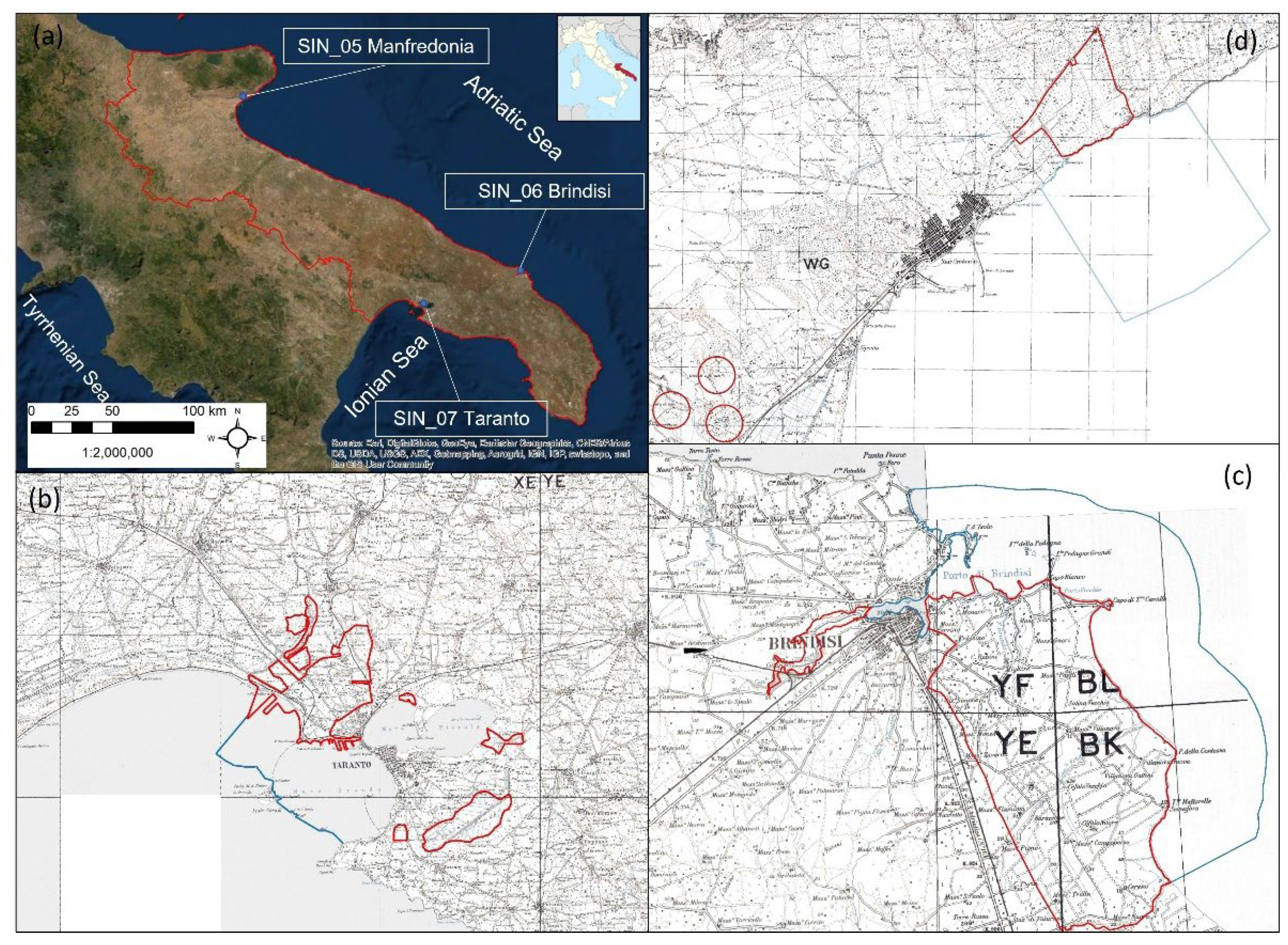
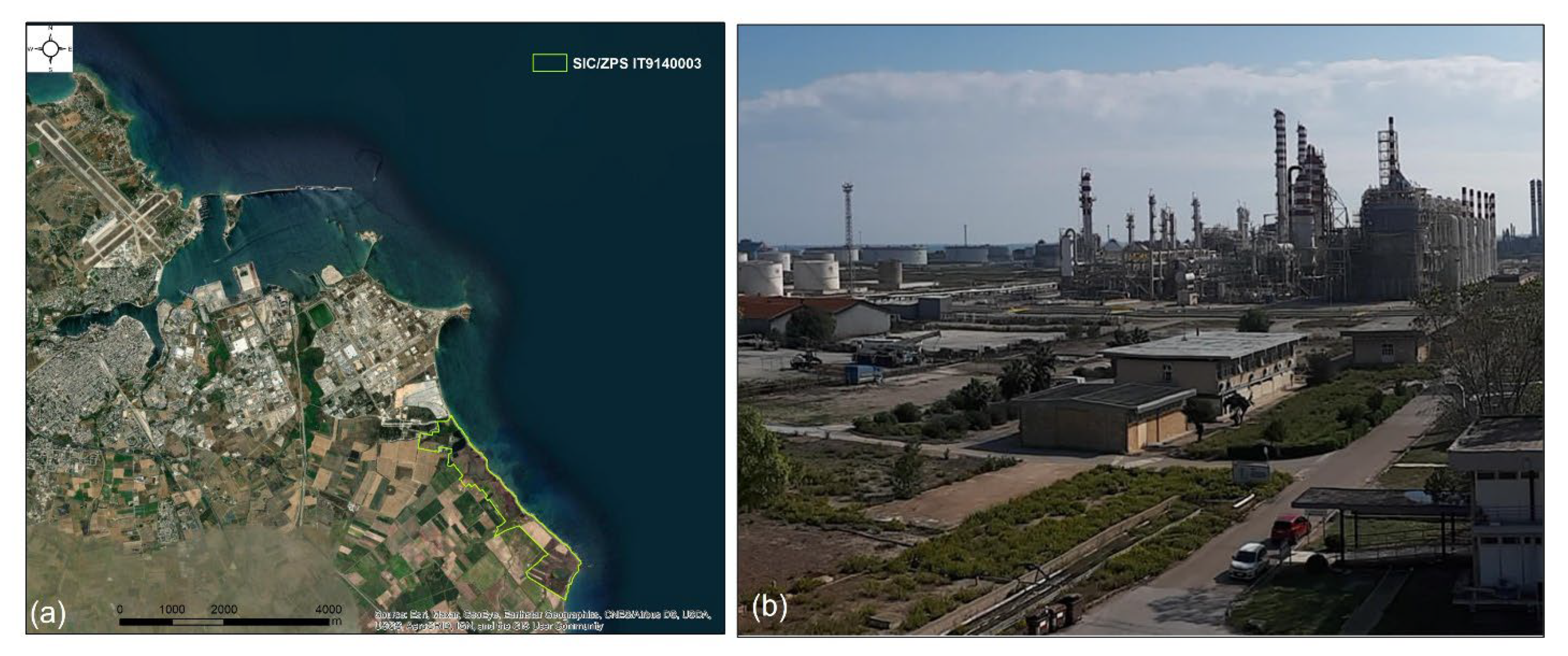
3.1. Physical and Environmental Setting of the Apulian Coastal SINs

The Apulian coastal SINs are located both on the Adriatic and the Ionian side of the Apulia region (Figure 2). From the geo-morphological point of view, the Apulia region presents varied characters that allow different districts characterised by specific physical features to be identified.
The SIN “Taranto” (SIN_07) is located on the northern Ionian coast of the Apulia region, between the south-western sector of the Apulian Foreland and the eastern Bradanic Trough, which represents the Pliocene-Pleistocene foredeep of the South Apennines orogenic system [47,48]. The Taranto coastal area is divided into two basins, called Mar Grande (“Big Sea”) and Mar Piccolo (“Little Sea”). The latter is divided by the N–S Punta Penne promontory in two connected embayments: the First Bay and the Second Bay; see Figure 3a. The Mar Piccolo is connected with the Mar Grande by two channels: the shallow natural one (“Porta Napoli” channel, showed in Figure 3a) and the artificial one (“Navigabile” channel, Figure 3a), excavated during the XIX century in the Pleistocene calcarenite [49]. The stratigraphy of the area consists of Mesozoic limestone (Calcare di Altamura Fm.), and Upper Pliocene–Lower Pleistocene calcarenite (Calcarenite di Gravina Fm.) passing upwards and laterally to the interfingered argille subappennine informal unit. Marine, transitional, and continental terraced deposits occur in the surrounding foreland and foredeep sectors [50,51] and reference therein.
The current landscape is dominated by a series of marine terraces, slightly dipping toward the sea whose deposits unconformably overlay the argille subappennine informal unit [48,50,52] (Figure 3b) forming quasi-flat surfaces consisting of marine terraces crossed by a fluvial network. The marine terraced deposits are located at different elevations (ranging from 2 m to 24 m above sea level (asl)) and show different lithostratigraphic features [49,53]. According to radiometric data [50], these marine terraces are connected to the sea-level highstand that occurred during the Last Interglacial (MIS 5) and they host a well-preserved marine record represented by a marly sandy unit with specimens of Thetystrombus latus (=Strombus bubonius, Gmelin, 1791) and other warm-water indicators such as Cladocora caespitosa (Linnaeus, 1767). Updated version of the geological and geomorphological map of the Taranto area have been proposed in Lisco et al. [54] at the 1:15,000 scale.
Due to its semi-enclosed features, the Taranto coastal area is characterised by a limited sea water circulation. Nevertheless, the presence of several submarine springs (Figure 3c), locally known as “Citri”, recharge the basins with freshwater. These submarine springs are characterised by a deep and steep inverted cone surface and by a high groundwater velocity determining an outflow visible on the seawater surface [55,56]. The outflows are characterised by high pressure and come from a karst aquifer developed into Mesozoic limestones. Citri are mainly located in the Mar Piccolo and are associated with subcircular depressions with variable depth up to 50 m in the Mar Grande and 30 m in the Mar Piccolo [57]. The peculiar hydrogeological characteristics of the Taranto coastal area have determined typical lagoonal features, which have favoured the distribution of transitional habitats and a very high biodiversity [34] for whose conservation and protection a Site of Community Importance (SCI-IT9130004 “Mar Piccolo”) of about 14 km2 has been established (Figure 3d).
The SIN “Brindisi” (SIN_06) is located on the eastern part of the Apulian region, on the Adriatic side. The marine coastal area included in the SIN_06 is constituted by a coastal stretch delimited to the North by Punta del Serrone and to the South by Cerano municipality; the area includes the Harbour of Brindisi and extends offshore up to 3 km. The Brindisi Harbour, one of the largest ports in the Mediterranean Sea, is divided into three main areas: Inner Harbour, Middle Harbour and Outer Harbour (Figure 4a). The Inner Harbour is formed by two long arms that encircle the city to the North and to the East, which are known, respectively, as “Seno di Ponente” and “Seno di Levante”, with a surface of approximately 727,000 m2. The seabed, with a depth varying between 2 and 7 m, is characterised by fine sediments. The Middle Harbour has an extension of 1,200,000 m2 and overlooks the areas devoted to shipbuilding. Finally, the Outer Harbour occupies approximately 3,000,000 m2. From a geological–structural point of view, the area represents a distensive tectonic depression, filled by the deposits of the “Bradanic Trough Cycle” and by subsequent “terraced marine deposits” [58]. In detail, starting from the most ancient unit, the following successions can be defined as follows: stratified Mesozoic limestone (Upper Cretaceous); sandy calcarenites (Upper Pliocene–Lower Pleistocene); blue-grey clays and sandy silty clays (Lower-Middle Pleistocene); yellowish sands with varying degrees of cementation or locally, organogenic calcarenites of a lithoid character (Upper Pleistocene); marine sands and sandy clays, marsh and lagoon silts (Holocene) [59]. In the area of Brindisi, calcarenitic facies belonging to the fourth lithostratigraphic unit outcrop. This unit is indicated in literature with the denomination of “terraced marine deposits”. The morphological features of Brindisi area is determined by a deep ria located at the mouth of Pigonati river and by the swamps on the backdune areas [59]. The main reference related to the geological setting of the area is represented by the Geological Map “Foglio 204–Lecce” at the scale 1:100,000 and its related illustrative notes [60]. In the southernmost sector of the SIN “Brindisi”, near the municipality of Cerano, a wide wetland area has been identified as a protected area (SCI/ZPS IT9140003 “Ponds and salt marshes of Punta Contessa”; see Figure 4a) due to its ecological value as a nesting and resting site of the migratory aquatic avifauna.
The SIN “Manfredonia” (SIN_05) is located in the Manfredonia Gulf (Adriatic Sea) on the southern part of the Gargano Promontory (Figure 2a,b). The marine coastal area in the SIN perimeter extends north of the Manfredoina industrial harbour and has an extension of about 4 km along the coast, for a total area of 860 ha (Figure 5, Table 2). Past geophysical surveys carried out by the Harbour Authority of Manfredonia allowed four lithological units to be identified, represented by: fine and homogeneous sediments (silts and clays) with a thickness up to 15 m; sands, silty sands, and gravelly sands (with limestone fragments) with a thickness varying from 10 to 15 m; intercalations of lenticular levels of clayey sands and gravels with compactness and resistance higher of the previous levels; limestones (Lower Cretaceous) covered by a cemented breccias of varying thickness. The depths at which the bedrock is reached increase towards the open sea. The main reference for the geological setting of the area is represented by the Geological Map “Foglio 164-Foggia” at the scale 1:100,000 and its related illustrative notes [61].

3.2. History of the Contamination and Status of Characterisation Procedures in the Apulian Coastal SINs

The area of Taranto has been affected by intensive environmental changes due to the strong industrialisation that has been taking place since the second half of the XIX century. The zone is characterised by a high concentration of industrial districts that have a high environmental impact, including the largest steelworks in Europe (Acciaierie d’Italia S.p.a.-ex-ILVA) inaugurated in 1965, the ENI refinery completed in 1964 and operative since 1967, the Taranto thermoelectric power plant (ex-Enipower S.p.A.), the Cemitaly plant (ex-Cementir), various landfills and numerous small and medium-sized manufacturing industries. Taranto also hosts one of the Italian Navy’s most important and historic bases, with the related arsenal and shipyards (Figure 3a). In addition, the coastal basins of Taranto are significantly impacted by intensive mussel aquaculture activities [62,63]. The presence of numerous industrial plants has led to serious environmental problems, which affect all environmental matrices (soil, air, water and marine sediments) and, for this reason, Taranto is considered one of the most polluted cities in the western Europe [40,64].
The area included in the SIN_06 “Brindisi” is characterised by different industrial settlements mainly consisting of chemical and energy plants, including the thermoelectric power plant of Brindisi. The northern part of the SIN_06 also includes a craft-industrial agglomerate (Figure 4b), while, in the central and southern part, the site is occupied by agricultural areas, with intensive cultivations and vineyards. Finally, the ENEL thermoelectric plant of Cerano (built in the 1980s and at present the second largest thermoelectric plant in Italy) is located in the southernmost sector of the site and it is connected to the harbour for fuel supplies. The agricultural areas, located in the central part of the site, are characterised by intensive cultivation and vineyards and by a complex system of drainage channels that intersect the services connecting the thermoelectric power plant to the industrial area and representing, therefore, potential critical points of surface contamination, as well as discharge pathways for chemicals used in agricultural activities. The agricultural land has been included in the SIN perimeter since it is considered highly prone to be affected by pollutants produced by the surrounding industrial sites.
The area included in the SIN_05 “Manfredonia” covers 216 ha, of which about 96 ha are private areas consisting of the Polo Chimico (ex Agricoltura S.p.A. ex Enichem), currently owned by Eni Rewind S.p.A (ex Syndial). The industrial plants are devoted to the production of nitrogenous fertilisers, various chemical products, and by the petrochemical pole. Private areas located adjacently to Eni Rewind S.p.A plants are devoted to agricultural uses (Figure 5). In addition, the site includes public areas consisting of landfills built in calcarenite quarries used in the 1970s as storage sites for unauthorised solid urban waste. The main environmental problem in SIN_05 is due to the past activities aimed at the production of nitrogenous fertilisers for agricultural use, chemical products for artificial fibres, technopolymers and/or aromatic intermediates. In addition, in 1976, an explosion in the industrial plant resulted in a large arsenic leak. Since 1999, Agricoltura S.p.A. has suspended all production activities.
Regarding the state of the procedures for the reclamation of the land and groundwater in the SINs, the MiTE periodically publishes an updated document in which all the data available for the national sites are synthetised. In Figure 6, the most updated maps relating to the status of the reclamation of the Apulian coastal SINs are shown [8].
With reference to the SIN_07 “Taranto” (Figure 6a), the most updated data, which are refereed to May 2021, show that the characterisation plan was implemented for an area of 1997 ha; the soil reclamation project has been approved for an area of 329 ha while the reclamation of the water table has been approved for a surface of 341 ha. The data show that surfaces of 355 ha (0.18% of the characterised area) and 325 ha (0.16% of the characterised area) do not show contaminated soils water, respectively. Regarding the SIN_06 “Brindisi” (Figure 6b), the data, referring to May 2021, show that the characterisation plan has been concluded and approved for 5206 ha (0.89% of the total SIN land surface). The reclamation plan has been approved for a 689 ha of contaminated soil and 915 ha of contaminated ground water. According to these data, a surface of 386 ha (corresponding to the 0.07% of the characterised SIN land surface) contained uncontaminated soil and a surface of 486 ha (0.09%) contained uncontaminated groundwater. Finally, accounting for the SIN_05 “Manfredonia” (Figure 6c), whose data were updated in June 2020, the characterisation plan has been approved for the total surface included in the perimeter while the reclamation plan has been approved for 73 ha for the soil and 168 ha for the groundwater/aquifer. According to these data, a surface of 38 ha (corresponding to the 17.6% of the SIN land surface) presents uncontaminated soil while the whole groundwater surface resulted to be affected by pollution.

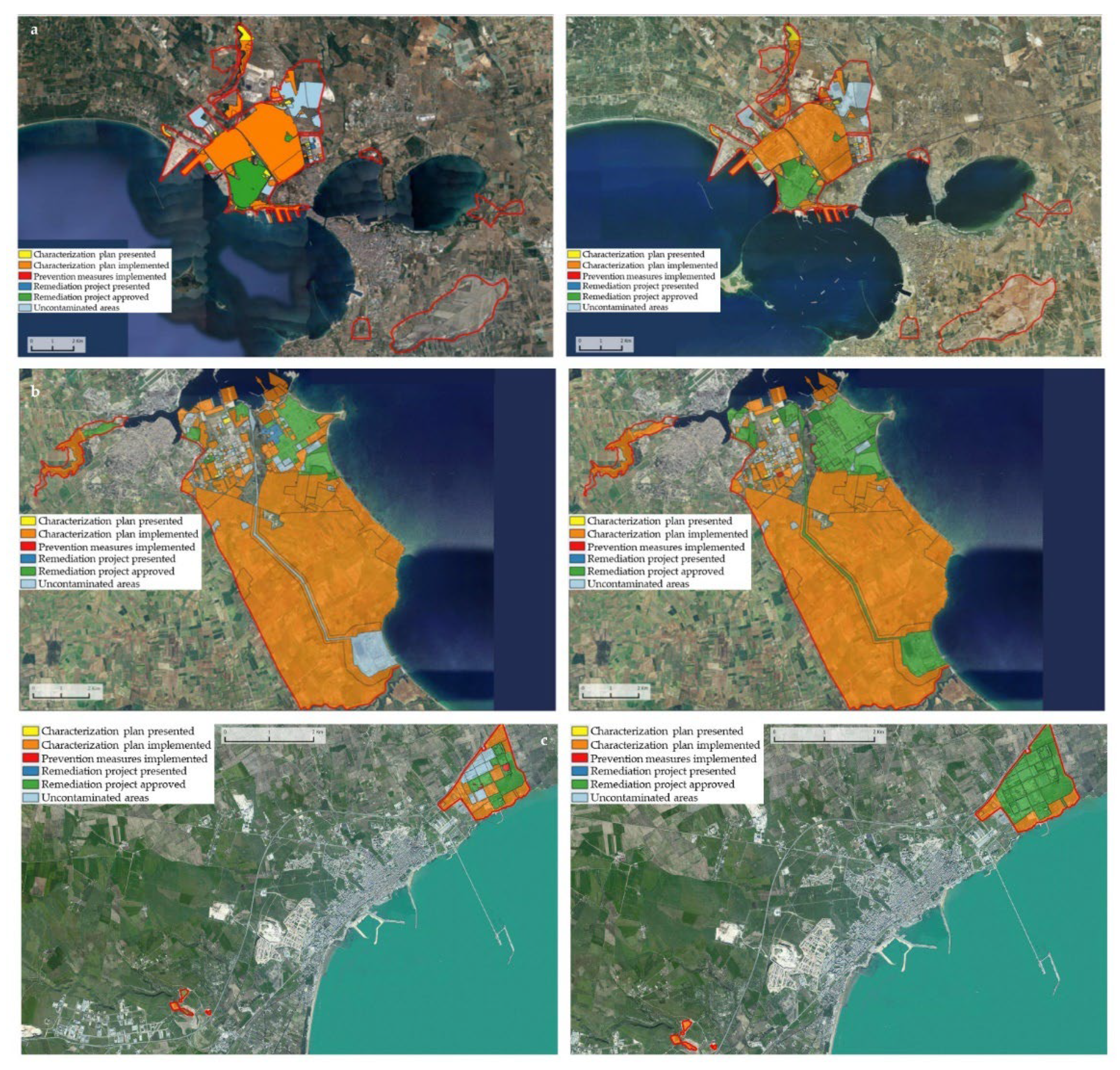
4. Overview about the Results from the Characterisation Activities Carried out in the Apulian Coastal SINs

In 2001, the Italian Institute for the Marine Research (ICRAM, now ISPRA) was commissioned by the Ministry of Environment (now MiTE) to define a methodological approach for the integrated environmental characterisation of the marine and coastal areas included the SINs. ISPRA proposed a flexible and large-scale monitoring program that was applied in the period 2004–2014 for the analysis of almost all the coastal marine areas in the SINs [10]. In detail, the proposed investigation strategy envisaged a sampling scheme with coastal grids varying in size (from 50 × 50 m to 450 × 450 m) according to the type, extension, and complexity of the investigated area. In each grid, a sediment core was executed (with a depth from 2 to 5 m) and a number of superficial samples were planned along transects covering the areas not included in the grid. A physical, chemical, and ecotoxicological analysis was carried out in standardised levels defined for the sediment cores. In order to evaluate the contamination level, the concentrations of the investigated pollutants were compared with the site-specific reference values determined in 2004 by ICRAM for the SINs and with the “CSC—Concentrazioni Soglia di Contaminazione”, which translates as “Contamination Threshold Concentrations” established by the national legislation (Legislative Decree 152/2006) for all the Italian industrial sites (Table 3).
The characterisation plans proposed for the Apulian coastal SINs were tailored accordingly to the site-specific geo-morphological characteristics and to the potential extent of the contaminated areas. The characterisation plan proposed for the SIN_06 “Brindisi” was released by ISPRA in 2011 [65]. Due to its large extent, the marine and coastal area included in the perimeters was divided in “Harbour Area”, which included the Inner, Middle, and Outer harbour, and “Coastal Area”, which included marine and coastal areas external to the Harbour up to the offshore limit of the SIN. The characterisation plan envisages the following activities: (i) preliminary investigations aimed at the detection of weapons; (ii) geophysical analysis aimed at calibrating the sampling grid; (iii) sediments cores and extractions of samples for the chemical analysis. The characterisation plan of the Harbour Area consisted of a 150 × 150 m sampling grid corresponding to 252 cores with a length ranging from 2 m to 3 m. The characterisation of the coastal area external to the Brindisi Harbour up to 500 m from the coastline was based on a sampling grid of 150 × 150 m and 206 sampling stations. Furthermore, in the marine area over 500 m from the coastline, samples were collected along 700 m-long transects; along each transect, several sampling stations spaced 500 m apart were identified (49 cores with a depth of 2 m and 64 superficial samples). Finally, along the beaches, the characterisation plan consisted of 67 linear transects spaced 150 m apart, along which a single core was to be extracted with a depth of 2–3 m. In total, the proposed characterisation activity consisted of the collection of 322 cores and 64 superficial samples. In addition, a tailored characterisation plan was defined for the Sant’Apollinare area, located in the Outer Harbour, in the frame of a specific agreement signed between ISPRA and Brindisi Harbour Authority [66]. In this case, the characterisation plan consisted of 65 sediment sampling stations within a regular grid measuring 50 × 50 m.
Due to the lack of previous environmental characterisations for the coastal and marine area included in the SIN_05 “Manfredonia”, no data for the identification of critical areas were available. For this reason, in 2004, ICRAM investigated the entire marine area included in the SIN [67]. The proposed characterisation plan consisted of a sampling grid of 150 × 150 m for the analysis of the marine area from the shoreline up to a distance of 600 m. In each cell, a sample core with a depth ranging from 2 m to 4 m was extracted. In the remaining marine area (from the distance of 600 m to the offshore SIN limit) eight sample transects perpendicular to the shoreline were defined with a spatial distance of 450 m. Along each transect, three or four sample stations (core and/or superficial sediments) were identified. In total, the characterisation activity consisted of the collection of 100 cores and 15 superficial samples.
The results of the characterisation plan proposed for the SIN_07 “Taranto” were released by ISPRA in 2011 [68] and was aimed at the characterisation of the entire marine and coastal area in the SIN perimeter which, due to its large area, was divided into four different sectors (i.e., “Punta Rondinella west area”, “Mar Grande–I Lotto”, “Mar Grande–II Lotto”, “Mar Piccolo”). The plan consisted of a total of 507 cores with variable length and 40 superficial sediment samples.

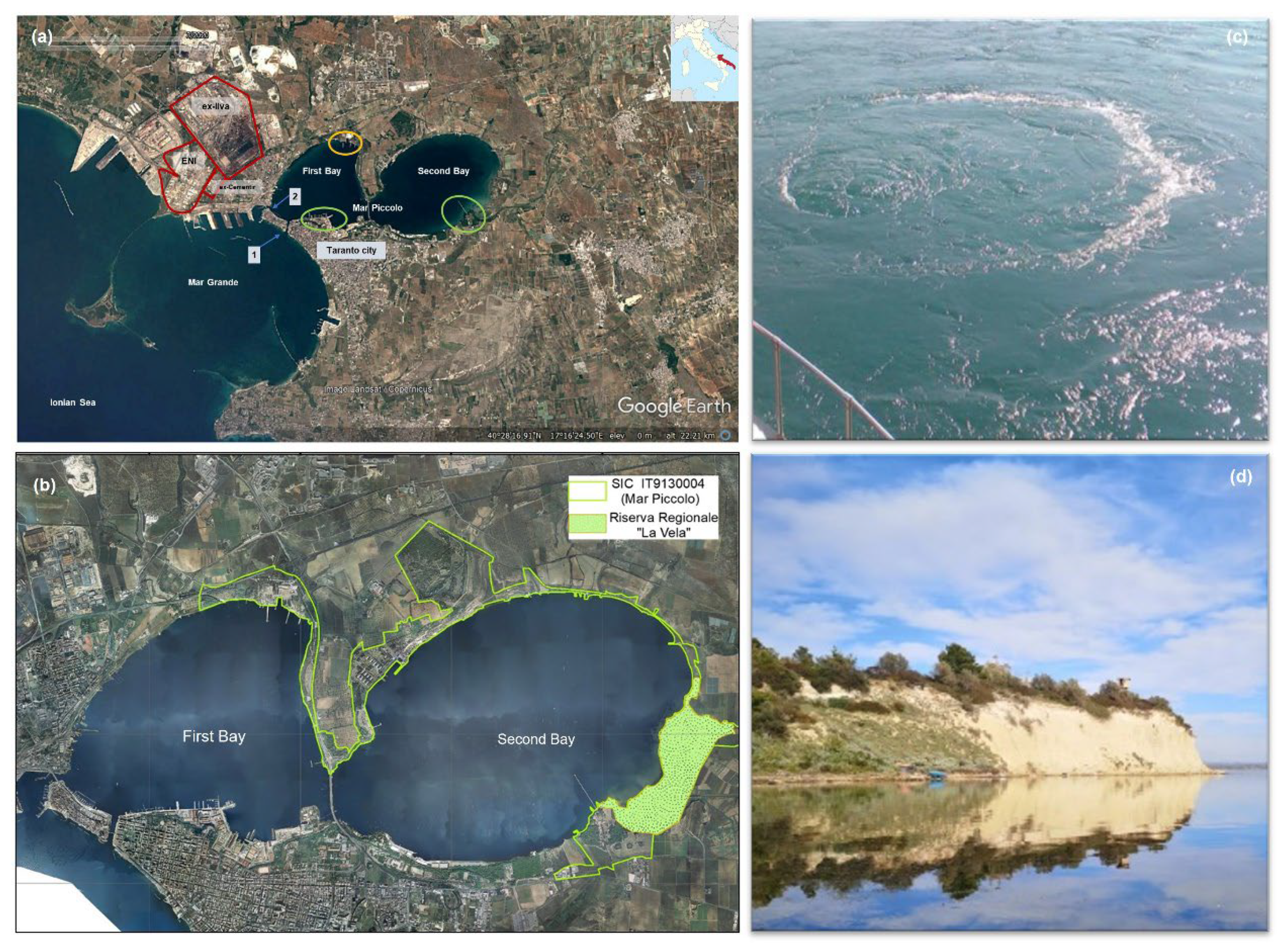
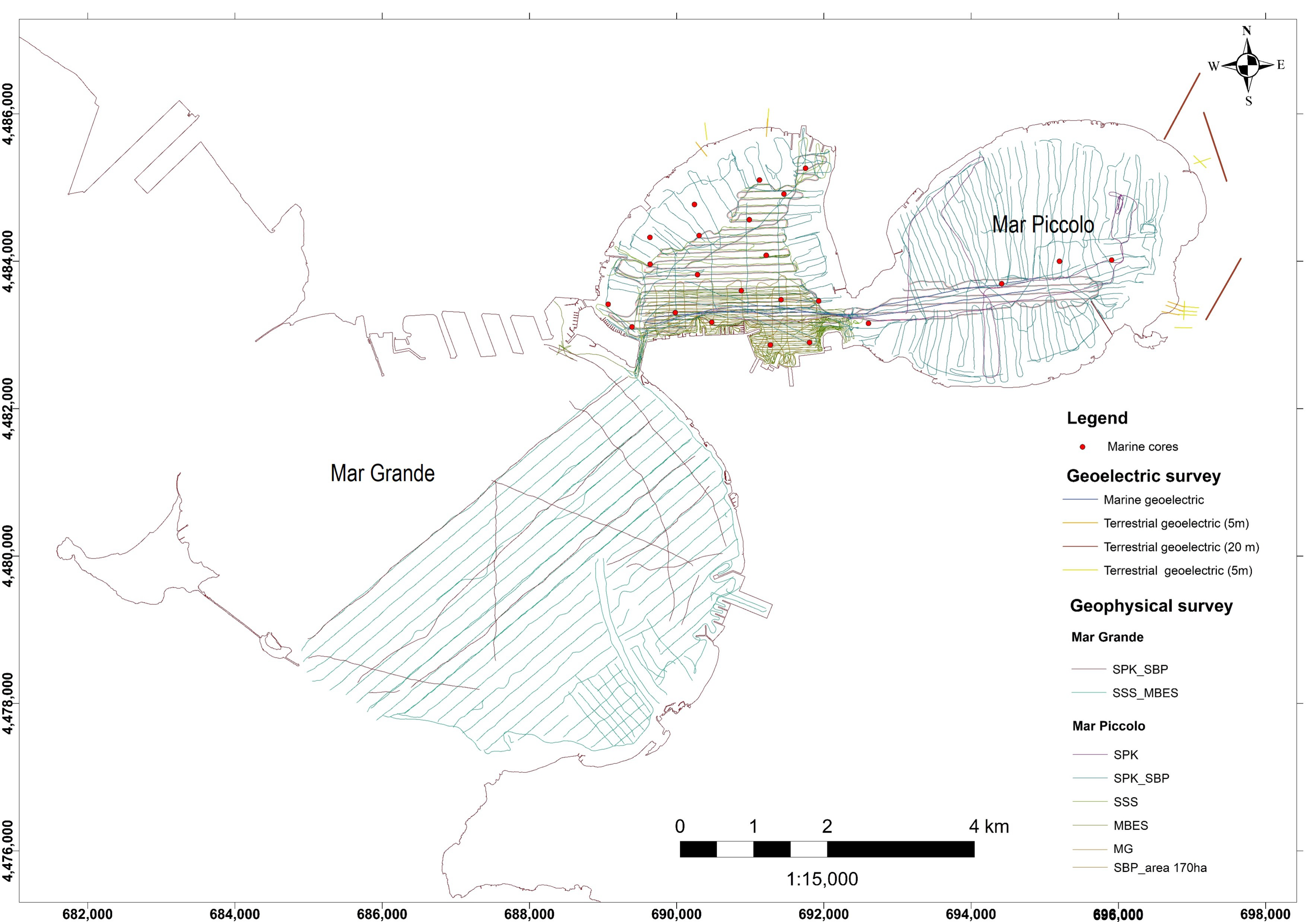
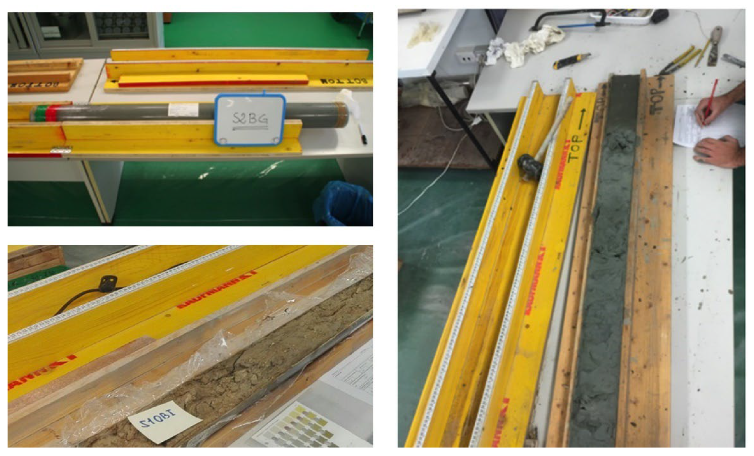
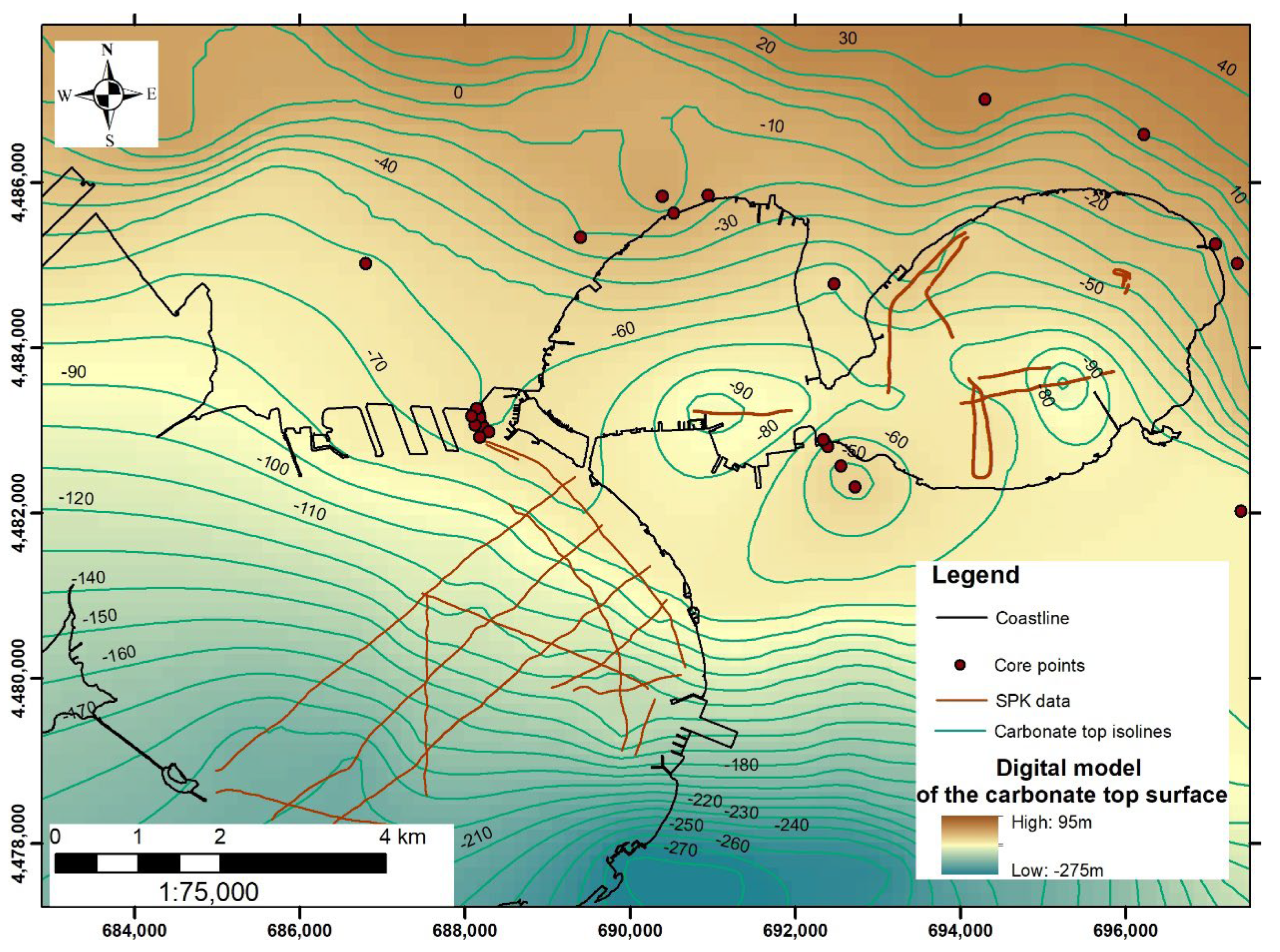
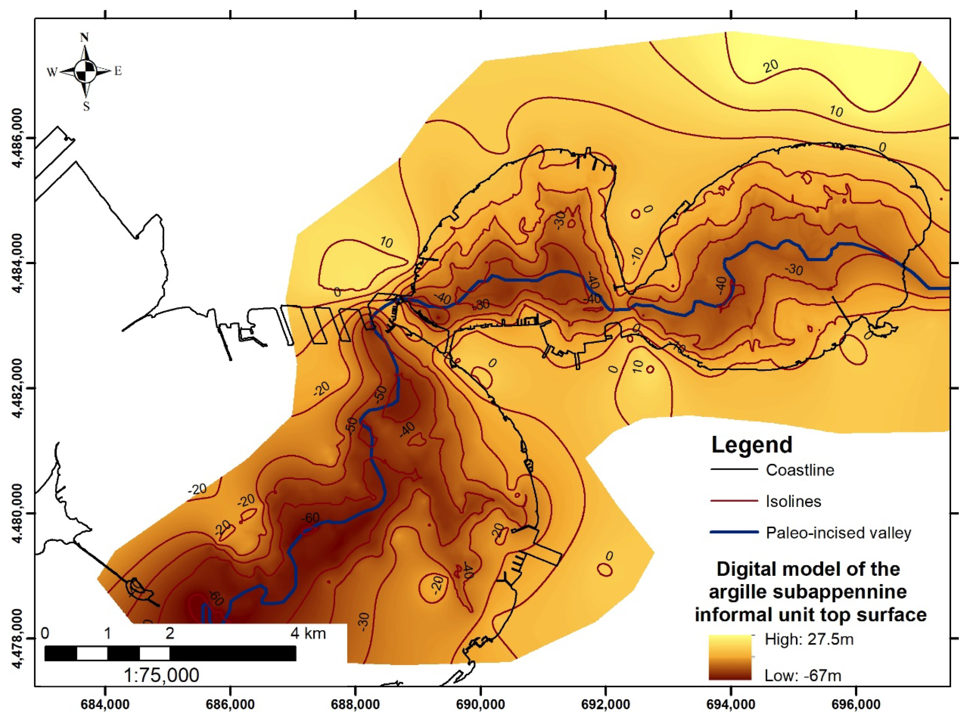
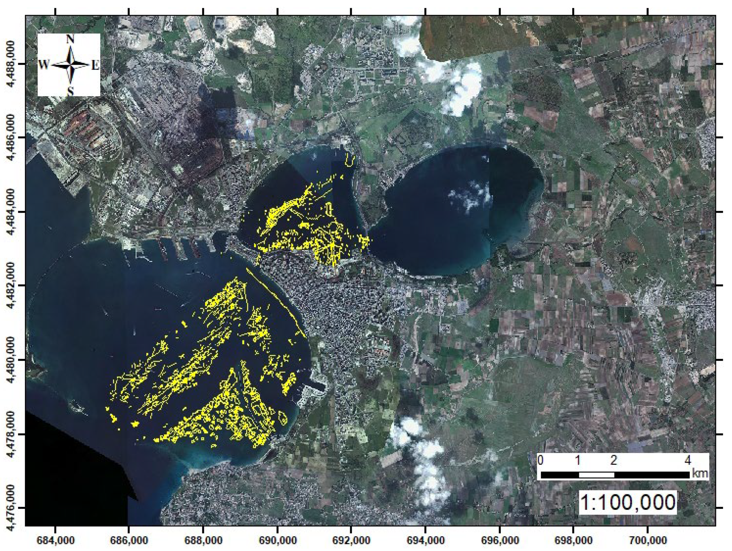
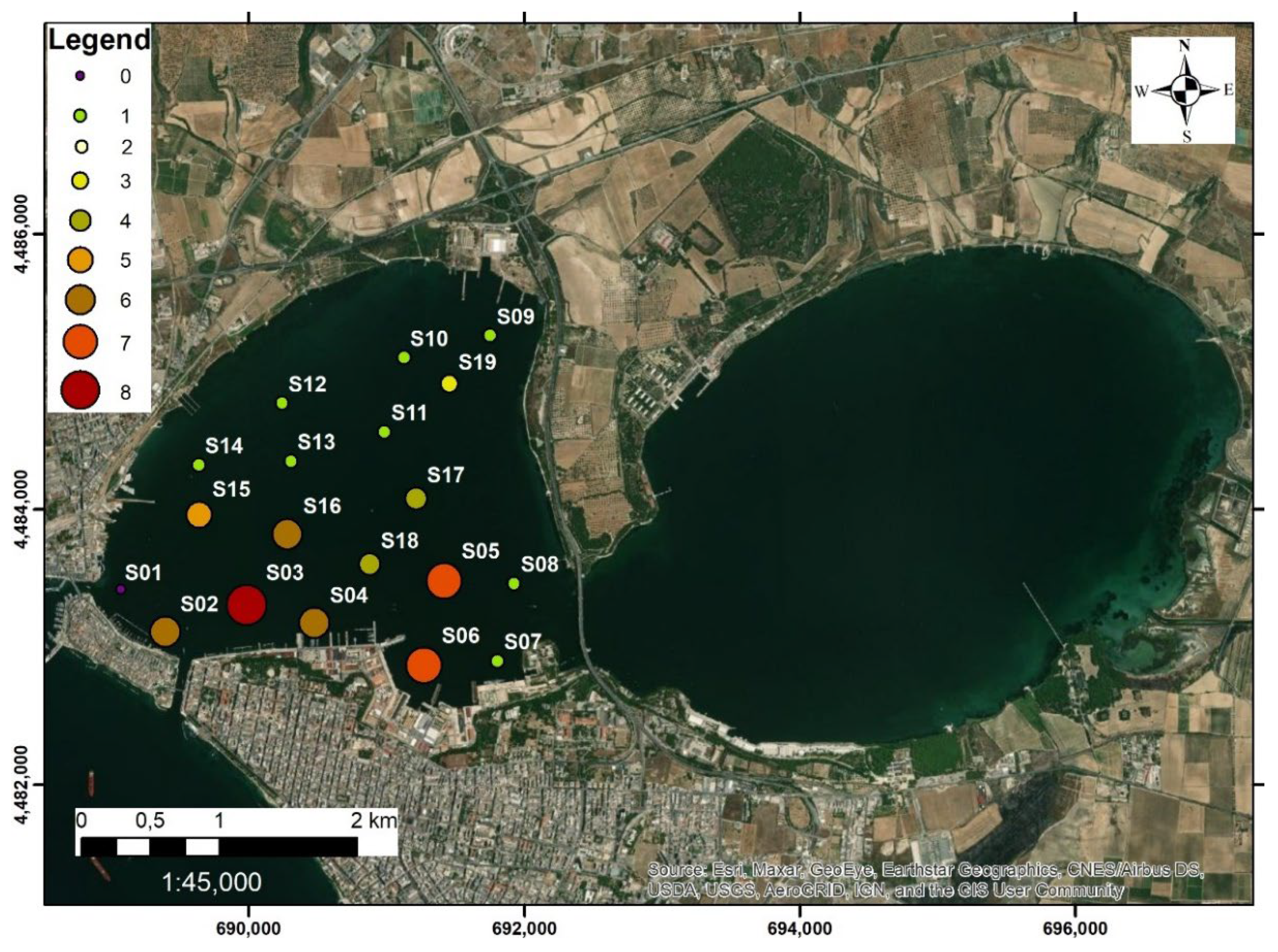
5. The Case Study of SIN_07 “Taranto”

5.1. Summary of the Characterisation Activities Performed from 2004 to 2015

The activities for the preliminary characterisation of marine and coastal area in the SIN_07 “Taranto” were conducted by ISPRA in the period July 2009–May 2010 [68]. The investigated area includes both the Mar Grande basin and the Mar Piccolo basin. Nevertheless, the southernmost sector of the First Bay in the Mar Piccolo basin (known as “Area 170 ha”) was not investigated. The geophysical activities executed in the frame of the characterisation plan included morpho-bathymetric (MultiBeam EchoSounder (MBES) and Side Scan Sonar (SSS)) and seismic surveys (Sub Bottom Profiler (SBP)). In the shallow water areas and in the zone where the navigation was not possible due to the presence of anthropogenic obstacles (i.e., mussel farms), the MBES survey was replaced by a Singlebeam survey. In addition, a magnetometric survey was also carried out to identify war devices on the seafloor. Regarding the sediment quality characterisation, 238 cores in the Mar Grande and 269 in the Mar Piccolo basin with variable length were extracted through a manual core barrel in the mussel farm areas and through a vibrocorer in remain areas. In addition, 40 superficial samples were extracted by a bucket. Approximately 2000 sediment samples from cores and bucket were used to carried out chemical–physical analysis. In particular, particle size, water content, specific weight, pH, redox potential, metals and trace elements, Polychlorobiphenyls (PCB), Organic pesticides, Lead, Copper, Zinc, Vanadium), Organochlorine pesticides, PAHs, Total Hydrocarbons (TPH), Light Hydrocarbons C ≤ 12, Heavy Hydrocarbons C > 12, Total Nitrogen, Total Phosphorus, Cyanides, and Organic Carbon (TOC) were analysed for almost all the samples in both the Mar Grande and Mar Piccolo. For a lower number of samples, further analyses were also performed (Chromium VI, Phenols, Aromatic solvents, Organotin compounds, Dioxins and Furans in part of the samples). In addition, microbiological parameters and ecotoxicological analysis were carried out on representative samples. To evaluate the contamination level, the concentrations of the investigated pollutants were compared with the site-specific reference values and with the “CSC” valid for all the Italian industrial sites (Table 3). The results of the integrated characterisation activities were provided as maps showing the spatial distribution of each parameter elaborated by means of geostatistical methods (Block kriging and Block Co-kriging). Data were interpolated up to the sediment thickness of 2 m in the areas not included in the mussel farm zones and up to 0.50 m for the samples in the mussel farm zones. Results showed that sediments in the Mar Grande are silty sands, sandy silts, and sands, while in the Mar Piccolo basin sediments are mostly silt and sandy silt. The chemical characterisation showed that the contamination in the Mar Grande basin was mostly due to metals and trace elements (Hg and Zn) and Cu, Pb, and As, the presence of which affected at least the first meter of sediment. High concentration levels of Hg were identified in the surface samples (with values even above the national limit in the first 0.50 m) and in the 0.50–1 m layer. In the central part of the basin, a high concentration of Hg was found, even at depths over 1 m. Contamination due to organic compounds was much less evident, both in terms of the extent of the affected area and depth, and this was mainly due to polycyclic aromatic hydrocarbons (PAHs), whose concentration exceeds the site-specific action level, and to TPH, whose concentration, in the same specific areas of the basin in proximity to the coastline, exceeded the value of 1000 mg/kg. In both cases, the contamination affected the first meter of sediment thickness.
The Mar Piccolo environmental state resulted to be very complex due to the presence of a high concentration of both inorganic and organic compounds, with special reference to the First Bay of the basin. The results of the chemical characterisation showed that Hg concentrations exceeded both the site-specific and the national limit in all the analysed surface sediment samples (0–0.50 m) of the First Bay. In the Second Bay, even though the site-specific limit was exceeded in a wide portion of the area, the results were lower in its central part and the easternmost sector. With regard to other metals and traces elements (Zn, Cu, Pb), their concentrations exceeded the site-specific action values both in the First Bay and in the Second Bay up to the 1 m sediment thickness. In the case of Zn, higher concentrations were found even in samples from deeper sediment layers (up to 2 m, when available). Nevertheless, national limits were not exceeded. Contamination from As affected sediment quality only in the First Bay. Considering the organic compounds, PCB concentration exceeded the site-specific action level in the northern sector of the First Bay, where in the shipyard area the contamination also affected the deeper sediment layers, and in the western sector of the Second Bay. National limit was exceeded only in the superficial sediment samples from the First Bay. Even if the TPH contamination affected only some areas mainly in the first bay, their concentration resulted to be higher than the threshold value up to deeper sediment layers (1.5 m). Finally, IPA exceeded the site-specific threshold in the First Bay mainly in the upper layer but, in some limited areas, they reached even the deeper layers. Maps showing the spatial and vertical distribution of organic and inorganic compounds in the Mar Piccolo basin can be consulted in Labianca et al. [40].
The analyses performed by ISPRA in the Mar Piccolo basin were further updated and integrated by the Regional Agency for the Prevention and Protection of the Environment (ARPA Puglia) who has defined and implemented (from May 2013 to April 2014) a technical–scientific programme of activities aimed at supporting the outline a conceptual model of contamination [27]. These analyses allowed the southernmost portion of the First Bay to be characterised; it was excluded from the characterisation performed by ISPRA. The results of program have led to a high number of interdisciplinary papers, which represent a scientific reference for the characterisation of the Mar Piccolo basin ([26] and reference there in).

5.2. Summary of the Characterisation Activities Founded by the Special Commissioner for Urgent Measures of Reclamation, Environmental Improvements, and Redevelopment of Taranto from 2015

The awareness of a widespread environmental risk [24,25,26], the epidemiological data indicating values above the national average for every type of cause of death [69], and the need to protect a territory characterised by a high socio-economic and geo-environmental relevance led, in 2014, to the definition of the Special Commissioner for the area of Taranto, who promoted an interdisciplinary study for the integrated characterisation of the coastal system in the SIN_07 perimeter. In this framework, new surveys were envisaged to obtain both direct and indirect data necessary for the geological, sedimentological, mineralogical, geochemical, and biological characterisation of the area.
Specifically, in the first phase of the study, started in 2016, the Mar Piccolo basin was investigated, while in the second phase (started in 2017), the survey activities were carried out in the Mar Grande basin. In Figure 7, the navigation lines defined for the acquisition of the geophysical data (Side Scan Sonar-SSS, MultiBeam-MBES, Sub Bottom Profiles-SBP, Sparker-SPK, Magnetometric-MG) are indicated (Figure 7). In the Mar Piccolo area, marine, coastal (land–sea interface), and terrestrial geoelectric surveys were also conducted (Figure 7). The profiles’ total length was 6675 m, with an interelectrode spacing of, respectively, 20 m and 5 m for the coastal and terrestrial profiles.
Regarding the direct analysis, in the period from September 2016 to March 2017, 24 sediment vibrocores were extracted in the Mar Piccolo basin using 1.5 m-long cores (Figure 7) at different sampling depths up to the limit of the argille subappennine informal nit. Each liner was appropriately sectioned so that it could be used for both sedimentological and chemical analyses. Once the cores were transported to the laboratories, a preliminary visual core description was carried out, taking into consideration the following parameters: degree of the drilling process disturbance, colour, lithological and granulometric characteristics, sedimentary structures, accessories (shells type, organic material, presence of glauconite or other minerals, concretions and nodules, archaeological findings) (Figure 8). Extensive physical and chemical analysis in the sediment samples from the First Bay basin were carried out. These activities included the determination of the following parameters: sediment granulometry, redox potential, organic matter, water content, organic and inorganic pollutants (PCBs, PAHs, TPH, TBT, DTB, MBT), metals (Pb, Cd, V, Ni, Cu, Zn, Hg, Cr, Fe, Al, Mn, As and Sn), and Dioxins and Furans. For the definition of the degree of contamination, the concentrations of the pollutants resulting from the chemical analyses were compared with the site-specific action levels established for the SIN_07 “Taranto” and with the national thresholds (CSC) (cf. Table 2).
Detailed description of the technical specifications of the geophysical survey as well as of the analytical procedures for the chemical analyses are reported in Valenzano et al. [33] and Cotecchia et al. [37], respectively. In order to obtain more details on the mineralogical composition of the sediment samples, further analyses were also carried out. These included the acquisition of magnetic susceptibility profiles, the detection of heavy metals in very small concentrations, the X-ray Fluorescence (XRF), X-ray Powder Diffraction (XRPD), and Trasmission Electron Microscope (TEM). Further analysis, such as liquid limit, plasticity index, activity index, soil solid-specific gravity, organic matter, void ratio, water content, and liquidity index, allowed estimate chemo-mechanical proprieties of the sediments.
The integrated interpretation of the geophysical data acquired in the Mar Piccolo with chronostratigraphic information derived from direct cores and 14C dating [35] allowed the geometrical relationships between sedimentary bodies to be defined, as well as their lateral continuity, thickness, and depth providing scientific support to the definition of the Holocene morpho-sedimentary evolution of basin [33]. In addition, through the qualitative description of the sediment samples, the main facies were identified and correlated with the seismic units obtained from the analysis and interpretation of the high-resolution single-channel seismic data (SBP and SPK). Specifically, through the interpretation of the SPK profiles, the upper limit of the carbonate substrate (Calcare di Altamura Fm.) was identified (Figure 9), on which, in discordance, it was possible to recognise a thick clayey succession referable to the informal stratigraphic unit of the argille subappennine (Pliocene–Middle Pleistocene) in heteropia with the Gravina Calcarenite Fm. (Pliocene). The digital model of the carbonate-top surface shown in Figure 9 has been obtained by interpolating available data from SPK interpretation and already available core data [33]. On the other hand, the interpretation of the SBP profiles had highlighted the thicknesses and geometries of the post-Last Glacial Maximum (LGM) units, which develop in the incised-valley morpho-stratigraphic system. As shown in Figure 10, this structure can be followed with good continuity from the Mar Piccolo basin to the Mar Grande basin [33,70].
The interpretation of the acoustic data (MBES and SSS) allowed the high resolution morpho-bathymetric setting of the coastal area to be defined, highlighting the morphological features that can be ascribed to local natural assets (i.e., Citri, [57]). In addition, these data represented a useful support for the identification and mapping of elements and traces from anthropogenic activities, providing, therefore, an indirect assessment of the human footprint in the seafloor. The analysis of the most recent acoustic data will certainly update the indirect and direct surveys already carried out in the past for the Mar Piccolo area [28,34], integrating the same analysis for the Mar Grande basin (Figure 11).
As far as the results obtained from the analysis of chemical parameters are concerned, they showed a substantial environmental criticality in the southern sector of the First Bay (i.e., the area defined as “Area 170 ha”). As regards the distribution of pollutants along the vertical profile of the sediments, it emerged that the highest concentrations characterise the first sediment layer (0–0.50 m). The concentrations of the analysed metals in the first sediment layer are indicated in Table 4.
As can be seen from the analysis of these data, most of the sediment samples present concentration of the inorganic compound higher than the site-specific action values. In surface samples relative to cores S02, S03, S04, S05, S06, S16, there are at least six concentrations of inorganic pollutant higher than the limit values. In sediments from core S03 and S06 the CSC limit value for the Hg is exceed. In Figure 12, the results of the chemical analysis performed on superficial sediments are summarised. Sediment cores are indicated with circles, whose sizes depend on the number of inorganic and organic pollutants exceeding site-specific thresholds.
However, the presence of some pollutants at higher depths, with concentrations even exceeding the threshold limits, infer the occurrence of local mixing phenomena in the more superficial and unconsolidated sediments. In particular, as highlighted by the authors of [71], who analysed and mapped the Organotin compounds concentrations in sediment samples up to 3 m, the greatest thickenings of reworked sediments were detected mostly in the southern and northwestern areas of the First Bay, where the bathymetric data showed a remarkable perturbation of the seafloor mainly ascribed to anthropogenic activities (e.g., dredging and wrecks). Cotecchia et al. [37] provided the analytical results for chemical, geotechnical, and mechanical proprieties evaluated for sediment sampled from six selected cores (S01, S02, S03, S04, S06, S07) from the sea-floor interface up to a depth of approximately 30 m. The results obtained from the analysis of chemical parameters updated the knowledge on contamination level in the Mar Piccolo basin. Nevertheless, no analysis has been carried out for the chemical characterisation of the sediment from the Mar Grande basin.
Comparing the analytical results obtained during the characterisation activities funded by the Special Commissioner with the international sediment quality guidelines ERM and ERL (effects range medium and effects range low), it emerged that the concentrations of As, Cr, Hg, Ni, Pb, Cu, and Zn exceed the ERL values at least in one sample; furthermore, Hg, Ni and Pb concentrations also exceed the ERM values (Table 5). Specifically, Ni concentrations exceed the ERL values in all the 19 samples, As and Hg concentrations exceed the ERL values in 16 samples (S02, S03, S04, S05, S06, S07, S08, S09, S11, S12, S14, S15, S16, S17, S18, S19 and S01, S02, S03, S04, S05, S06, S07, S08, S09, S11, S14, S15, S16, S17, S18, S19, respectively), Cr concentrations exceed the ERL values in 15 samples (S04, S05, S06, S07, S08, S09, S11, S12, S13, S14, S15, S16, S17, S18, S19), Pb and Cu concentrations exceed the ERL values in 10 samples (S02, S03, S04, S05, S06, S15, S16, S17, S18 and S02, S03, S04, S05, S06, S15, S16, S17, S18, S19, respectively). Finally, Zn concentrations exceed the ERL values in six samples (S02, S03, S04, S05, S06, S16). Considering the ERM values, Hg concentrations are higher in 11 samples (S02, S03, S04, S05, S06, S11, S15, S16, S17, S18, S19), Ni concentrations are higher in all the samples excluding S10 and S10, and Pb concentrations are higher in samples S3 and S6. Nevertheless, it is worth noting that the use of indicators such as ERL and ERM can be considered as a first attempt to link the bulk chemistry with toxicity [72,73,74,75]. Chemical concentrations below the ERL value represent a range below which adverse biological effect would rarely be observed; similarity, the ERM values represent a potential range above which adverse effects on biological systems would frequently occur [72].

6. Discussion on Methodological Procedures Available for the Integrated Characterisation of the Coastal Contaminated Sites

As shown in the review of scientific papers available at the national and regional scale [25,28,76,77,78,79,80,81,82,83,84,85], the different types of analysis generally envisaged to perform the geo-environmental characterisation of contaminated coastal sites represent a starting point for the assessment of the level of anthropogenic impact on marine environmental matrices. Nevertheless, many of these analyses may support the definition of a geo-morphodynamic model of the investigated area. Based on the review of the achievements of previous analysis carried out in the Taranto area and by the support of expert-based judgments provided by who were involved in the multidisciplinary activities funded by the Special Commissioner, a specific suitability level in the definition of geological model and/or anthropogenic impact has been assigned to each investigation performed for the characterisation of the area in the SIN_07 “Taranto”. The suitability has been ranked in three classes, as follows:
  • “High suitability” level has been assigned to the investigations that allow reliable data to be obtained, the interpretation of which can be considered independent from other analyses.
  • “Medium suitability” has been assigned to those investigations that require the integration of further analysis to be to be properly interpreted. Medium suitability analyses should be coupled with high suitability analyses.
  • “Low suitability” has been assigned to investigations that give a minor contribution to the achievement of the main goal of the analysis. Low suitability analyses should be coupled with medium and high suitability analyses.
In Table 6, the suitability levels are indicated considering the definition of the geomorphodynamic model and anthropogenic impact as main outcomes. The investigation activities have been grouped as it follows: geophysical and geoelectrical surveys, chemical analysis on sediment samples at different depths from the sea–floor interface, and physical, geo-chemical, and bio-chemical analyses on sediments and biota eventually found in them.
From this evaluation, it is evident that several surveys (e.g., acoustic surveys, SBP surveys, concertation of inorganic compounds) allow the acquisition of informative layers that may support both the assessment of site-specific geological features and the environmental characterisation of the investigated site. Furthermore, the indirect geophysical surveys play a significant role in terms of featuring the sediment variability and therefore for orienting the definition of the most suitable sampling grids, which should be tailored according to the site-specific lithological and sedimentological peculiarities. For this reason, they may be considered as priority in the definition of a cost-efficient characterisation program. Several investigations need to be coupled with other surveys to obtain high informative data. By way of example, SBP data, coupled with punctual information on the contaminants’ concentrations, allow the spatial correlation among sediments samples and sedimentary units to be defined. Some investigations (e.g., SPK surveys, radiocarbon dating, palynological analysis) are considered to be very useful for the identification of geological, stratigraphical, and paleo-environmental features, but their usefulness in supporting the evaluation of the anthropogenic impacts on marine matrices is considered low. On the other hand, the analysis of the organic compounds is of paramount importance in the definition of the environmental status, but it does not provide any relevant details useful for the analysis of the geo-morph dynamics of the investigated areas.
Furthermore, taking into consideration the Driver-Pressure-State-Impact-Response (DPSIR) model, which represents a “causal framework for describing the interactions between society and the environment” (EEA, 1999), the analyses envisaged for the geo-environmental characterisation of coastal contaminated sites may be considered as key factors for the definition of the parameter “State”, which identifies the physical, chemical, and biological conditions of the environment and its related matrices.
This aspect can be highlighted in the review paper published by Labianca et al. [40], who have proposed a specific DPSIR model for the Mar Piccolo basin (Figure 13). In their site-specific DPSIR scheme, the authors identified key elements for each parameter of the model, as follows:
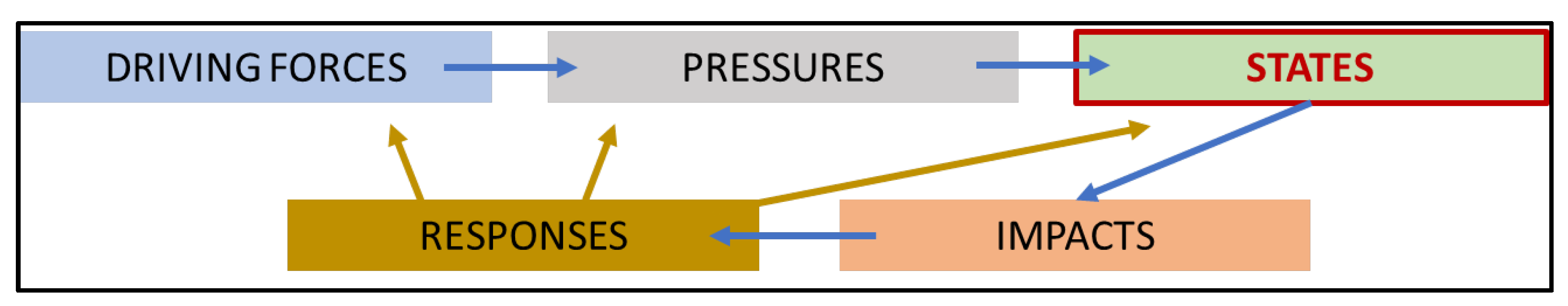
  • Driving forces: demography, agriculture, industry, landfills and treatment plants;
  • Pressures: discharge of nutrients and contaminants, pollution in groundwater, air pollution;
  • States: marine sediment characterisation, sea water characterisation, biodiversity monitoring, anthropisation of sea bottom assessment, marine litter identification;
  • Impacts: contaminants mobility, effects of contaminants on marine organisms, effect of pollution on human health, eutrophication;
  • Responses: political approaches, remediation strategies.
According to the proposed model, operational (short-term) and strategic (medium- and long-term) management responses can interact with forces, pressures, and states. Specifically, while structural and political measures may influence the driving factors, remediation strategies help to reduce environmental degradation and to restore higher environmental quality. Accounting for the above-mentioned parameters, it appears to be clear that the results achieved through the characterisation activities carried out by national and regional scientific entities (ISPRA, ARPA, Special Commissioner, Universities, CNR) are preparatory for the definition of the current environment state as well as for the identification of the main geomorphological and sedimentological factors that may contribute to the pollutants’ accumulation and redistribution. From this perspective, it is considered worthwhile to define a scheme of priority actions to be undertaken in a cost- and operative-effective way.
From the review of the manuals and guidelines drawn up at the national level (cf. Section 2), it emerged that, at present, there are no nationally recognised operative guidelines to refer to for the characterisation of geo-morphodynamic aspects and processes that can induce changes in the coastal environments in the SINs. Therefore, the need to define a scientific protocol of investigations has led to funding a three-year research project supported under a special fund of the Apulia Region financed by the European Union. Activities envisaged under the ongoing research project include: (i) integrated data analysis for the identification of the potential correlation factors between the site-specific geological setting and contamination features; (ii) analysis of geo-morphodynamic factors that may induce changes in the coastal environment resulting in redistribution of the pollutants; (iii) definition of potential environmental risk scenarios. A synthesis of the activities scheduled in the project is reported in Figure 14. The main outcomes of the project will be represented by a set of guidelines specifically defined to address the characterisation activities towards the definition of the geo-morphodynamic model of the investigated area and to support the assessment of environmental and coastal risk scenarios. The project is based on the set of data and information already available for the Taranto area that, at the regional scale, results to be the site for which a higher number of scientific references on its integrated characterisation area available. Nevertheless, to support the definition of the geo-morphological, stratigraphical, and sedimentological features of the Taranto area, new geophysical surveys aimed at the realisation of morpho-topographic and morpho-bathymetric models with high spatial resolution having started and are still in progress (funded by ISPRA in the frame of the national project “CARG” for the realisation of the Geological Map of Italy at the scale 1:50,000 https://www.isprambiente.gov.it/Media/carg/puglia.html, accessed on 3 May 2022).
Although the site-specific characteristics (type of coastal system, type of industrial activity) should be considered, it is worth noting that the definition of guidelines should comply with a set of general criteria valid for all types of contaminated coastal sites [10]. Among these, physical parameters such as sediments size and organic content must be accounted for the definition of pollutants accumulation processes. In addition, the geo-chemical sediment characterisation should include both the surface sediments and the deeper layers to define the vertical distribution of the contaminants. To this aim, it is considered necessary to carry out both in situ cores to support the direct analyses on sediments at different depths and the acquisition of geophysical data to support the spatial correlation among data derived from cores (point data). The storage, processing, and representation of a huge amount of data required for the characterisation of highly contaminated sites cannot disregard the creation of specific geographical multidisciplinary geodatabase which enables the reconstruct of the evolution of the contamination status over time for the different environmental matrices [86].
Furthermore, the definition of a site-specific geo-morphodynamic model cannot disregard the evaluation of physical processes that may induce variations in the coastal setting and enhance the distribution of pollutants. These processes should include both superficial surface processes (e.g., water and solid discharge from river systems) and marine and coastal processes [87,88,89] (e.g., coastal erosion, coastal flooding, sea level rise). Final considerations about this last aspect are related to the potential effect of climate change on spatial and temporal occurrence of weather-related extreme events (e.g., heavy rainfall, storm surge) that may enhance the magnitude of already occurring processes. As highlighted by [90,91], coastal changes induced by climate and marine processes may undermine remediation and risk management strategies implemented in the contaminated sites and reduce the effectiveness of the original site remediation design.

7. Conclusions

The activities carried out in recent years for the characterisation of marine and coastal areas in the Apulian SINs provided in-depth knowledge of their environmental status. With regard to the SIN_07 “Taranto”, the results obtained from the analysis of chemical parameters show a remarkable environmental criticality in the southern sector of the First Bay (in the Mar Piccolo basin), in the area defined as “Area 170 ha”. Accounting for the distribution of pollutants along the vertical profile of the sediments, the highest pollutant concentrations characterise the first 50 cm of the samples. Referring to the national limits, Ni and Cr concentrations exceed the site-specific values in 95% and 90% of the sample, respectively, while Zn concentration exceeds the site-specific values in 58%. The concentration of Hg exceeds both the site-specific value (in 47% of the samples) and the national CSC value (11% of the samples). Taking into consideration the international guidelines, 84% of the samples exceed the ERL values for As and Hg, 79% for Cr, 53% for Pb and Cu, and 32% for Zn. Finally, 100% of the samples exceed the ERL value for Ni. Furthermore, the interpretation of the acoustic data acquired during the geophysical surveys has allowed traces of direct and indirect impacts of anthropogenic activities on the seafloor to be identified, which are widely distributed both in the Mar Grande and in the Mar Piccolo.
In this review, based on a critical analysis of the surveys performed in the Apulian SINs, with particular reference to SIN_07 “Taranto”, a suitability level has been assigned to each of the performed survey, taking into consideration their usefulness in supporting the definition of the site-specific geo-morphodynamic model and the anthropogenic impact on the environmental matrices. This kind of expert-based evaluation represents the starting point for the definition of a protocol of investigations to be proposed as an operational tool for the selection of the analysis, direct and indirect, to be carried out for a comprehensive characterisation of the geo-morfodynamic setting and environmental state of the coastal contaminated sites. The protocol will support stakeholders in the definition of the conceptual model of the contaminated sites and it will be a useful tool for their environmental restoration. At the regional scale, the guidelines can support the characterisation the five orphan sites approved by MiTE. Furthermore, the National Recovery and Resilience Plan within the Next Generation EU could represent a great opportunity for the definition and implementation of safety measures of the sites to be reclaimed. This last aspect could promote the use of the investigation protocol on a national and international scale.

Author Contributions

Conceptualization, A.R. and G.M.; methodology, A.R. and G.M.; validation, A.R., G.M., G.S. (Giovanni Scicchitano) and M.M.; formal analysis, A.R.; data curation, A.R., F.D.G., G.S. (Giovanni Scardino), A.D.L. and S.L.; writing—original draft preparation, A.R.; writing—review and editing, A.R.; G.M., G.S. (Giovanni Scicchitano), M.M., F.D.G., G.S. (Giovanni Scardino), A.D.L. and S.L.; supervision, G.M.; project administration, A.R. All authors have read and agreed to the published version of the manuscript.

Funding

This research was funded by the Apulia Region (Italy) under the European Regional Development Fund and the European Social Fund (POR Puglia FESR-FSE 2014-2020)-Action 10.4 “Research for Innovation” (REFIN). Research project reference number: FC44BB89. Scientific responsible: Dr. Angela Rizzo.

Data Availability Statement

Data used in this study are derived from the surveys and analysis performed during activities envisaged in “Phase F” and “Phase G” of the Collaboration Agreement “Activities of common interest preparatory to the implementation of the interventions for the reclamation, and requalification of the Mar Piccolo of Taranto” signed in 2015 between the Special Commissioner for urgent measurements of reclamation, environmental improvements, and redevelopment of Taranto, the University of Bari Aldo Moro, and the National Research Council (Scientific responsible of “Phase F” and “Phase G”: Prof. Giuseppe Mastronuzzi).

Acknowledgments

The authors are thankful to the Special Commissioner for urgent measurements of reclamation, environmental improvements, and redevelopment of Taranto, Vera Corbelli, who coordinated the characterisation activities in the Taranto area. Scientific activities carried out in the framework of the Collaboration Agreement “Activities of common interest preparatory to the implementation of interventions for the reclamation and requalification of the Mar Piccolo of Taranto” signed with the Special Commissioner were carried out in collaboration with the University of Bari Aldo Moro and the National Research Council. The authors would like to thank Angelo Tursi and Vito Felice Uricchio, as Scientific Managers of the above-mentioned Collaboration Agreement, and Nicola Cardellicchio and Giuseppe Mascolo, as Scientific Managers of the investigation activities related to the “Chemical-physical, microbiological, and ecotoxicological investigations and analyses of sediments in the Mar Piccolo of Taranto” (“Phase H” of the Collaboration Agreement). The authors are also grateful to Biagio Ciuffreda and to Avv. Rosario Arcadio, Port Labour Manager at “Dipartimento di esercizio dei porti di Brindisi e Monopoli” of Autorità di Sistema Portuale del Mare Adriatico Meridionale, who have provided remarkable documents consulted in this review. Finally, the Authors thanks Sabrina Terracciano for her support in the preparation of Figure 11.

Conflicts of Interest

The authors declare no conflict of interest.

References

  1. Gómez, J.A. SUPERFUND: EPA Should Take Additional Actions to Manage Risks from Climate Change Effects; GAO-20-73; U.S. Government Accountability Office: Washington, DC, USA, 2019; p. 66.
  2. Manzoor, R.; Zhang, T.; Zhang, X.; Wang, M.; Pan, J.-F.; Wang, Z.; Zhang, B. Single and Combined Metal Contamination in Coastal Environments in China: Current Status and Potential Ecological Risk Evaluation. Environ. Sci. Pollut. Res. Int. 2018, 25, 1044–1054. [Google Scholar] [CrossRef] [PubMed]
  3. Minkina, T.M.; Nevidomskaya, D.G.; Pol’shina, T.N.; Fedorov, Y.A.; Mandzhieva, S.S.; Chaplygin, V.A.; Bauer, T.V.; Burachevskaya, M.V. Heavy Metals in the Soil–Plant System of the Don River Estuarine Region and the Taganrog Bay Coast. J. Soils Sediments 2017, 17, 1474–1491. [Google Scholar] [CrossRef]
  4. Micheli, F.; Halpern, B.S.; Walbridge, S.; Ciriaco, S.; Ferretti, F.; Fraschetti, S.; Lewison, R.; Nykjaer, L.; Rosenberg, A.A. Cumulative Human Impacts on Mediterranean and Black Sea Marine Ecosystems: Assessing Current PressuRes. and Opportunities. PLoS ONE 2013, 8, e79889. [Google Scholar] [CrossRef] [PubMed] [Green Version]
  5. Civili, F.S. The Land-Based Pollution of the Mediterranean Sea: Present State and Prospects; IEMed: New Delhi, India, 2010; p. 5. [Google Scholar]
  6. Lehoux, A.P.; Petersen, K.; Leppänen, M.T.; Snowball, I.; Olsen, M. Status of Contaminated Marine Sediments in Four Nordic Countries: Assessments, Regulations, and Remediation Approaches. J. Soils Sediments 2020, 20, 2619–2629. [Google Scholar] [CrossRef] [Green Version]
  7. Brand, J.H.; Spencer, K.L.; O’shea, F.T.; Lindsay, J.E. Potential Pollution Risks of Historic Landfills on Low-Lying Coasts and Estuaries. WIREs Water 2018, 5, e1264. [Google Scholar] [CrossRef] [Green Version]
  8. MITE. Available online: https://bonifichesiticontaminati.mite.gov.it/Sin/istituzione-Perimetrazione/ (accessed on 3 May 2022).
  9. ISPRA Siti di Interesse Nazionale (SIN). Available online: https://www.isprambiente.gov.it/it/attivita/suolo-e-territorio/siti-contaminati/siti-di-interesse-nazionale-sin (accessed on 3 May 2022).
  10. Ausili, A.; Bergamin, L.; Romano, E. Environmental Status of Italian Coastal Marine Areas Affected by Long History of Contamination. Front. Environ. Sci. 2020, 8, 34. [Google Scholar] [CrossRef]
  11. Ausili, A.; Romano, E.; Mumelter, E.; Tornato, A. Stato dell’arte Sulle Bonifiche delle Aree Marine e di Transizione Interne ai SIN. In Proceedings of the Workshop “Siti Contaminati. Esperienze negli Interventi di Risanamento” (Universitá di Catania: TEAM PA), Sicily, Italy, 9–11 February 2012; pp. 27–45. [Google Scholar]
  12. Zoumis, T.; Schmidt, A.; Grigorova, L.; Calmano, W. Contaminants in Sediments: Remobilisation and Demobilisation. Sci. Total Environ. 2001, 266, 195–202. [Google Scholar] [CrossRef]
  13. Fichet, D.; Boucher, G.; Radenac, G.; Miramand, P. Concentration and Mobilization of Cd, Cu, Pb and Zn by Meiofauna Populations Living in Harbour Sediment: Their Role in the Heavy Metal Flux from Sediment to Food Web. Sci. Total Environ. 1999, 243–244, 263–272. [Google Scholar] [CrossRef]
  14. Linnik, P.M.; Zubenko, I.B. Role of Bottom Sediments in the Secondary Pollution of Aquatic Environments by Heavy-Metal Compounds. Lakes Reserv. Sci. Policy Manag. Sustain. Use 2000, 5, 11–21. [Google Scholar] [CrossRef]
  15. Spada, L.; Annicchiarico, C.; Cardellicchio, N.; Giandomenico, S.; di Leo, A. Mercury and Methylmercury Concentrations in Mediterranean Seafood and Surface Sediments, Intake Evaluation and Risk for Consumers. Int. J. Hyg. Environ. Health 2012, 215, 418–426. [Google Scholar] [CrossRef]
  16. Baldrighi, E.; Semprucci, F.; Franzo, A.; Cvitkovic, I.; Bogner, D.; Despalatovic, M.; Berto, D.; Formalewicz, M.M.; Scarpato, A.; Frapiccini, E.; et al. Meiofaunal Communities in Four Adriatic Ports: Baseline Data for Risk Assessment in Ballast Water Management. Mar. Pollut. Bull. 2019, 147, 171–184. [Google Scholar] [CrossRef]
  17. Bellas, J.; Nieto, Ó.; Beiras, R. Integrative Assessment of Coastal Pollution: Development and Evaluation of Sediment Quality Criteria from Chemical Contamination and Ecotoxicological Data. Cont. Shelf Res. 2011, 31, 448–456. [Google Scholar] [CrossRef]
  18. Damiani, V.; Bianchi, C.N.; Ferretti, O.; Bedulli, D.; Morri, C.; Viel, M.; Zurlini, G. Risultati di Una Ricerca Ecologica Sul Sistema Marino Costiero Pugliese. Thalass. Salentina 1988, 18, 153–169. [Google Scholar]
  19. Mastronuzzi, G.; Valletta, S.; Damiani, A.; Fiore, A.; Francescangeli, R.; Giandonato, P.B.; Iurilli, V.; Sabato, L. Geositi della Puglia; AA.VV.; Sagraf/Società Italiana di Geologia Ambientale (SIGEA): Capurso, Italy, 2015; ISBN 978-88-906716-8-5. [Google Scholar]
  20. Mastronuzzi, G.; Milella, M.; Parise, M.; Piscitelli, A.; Scardino, G. Patrimonio Culturale e Geositi Dell’area Murgiana. Geol. Ambiente 2020, 43–50. [Google Scholar]
  21. Buongiorno, A.; Intini, M. Sustainable Tourism and Mobility Development in Natural Protected Areas: Evidence from Apulia. Land Use Policy 2021, 101, 105220. [Google Scholar] [CrossRef]
  22. ARPA. Mar Piccolo of Taranto—Scientific-Technical Report on the Interaction between the Environmental System and Contaminants Flows from Primary and Secondary Sources; Technical Report, 1; ARPA: Bari, Italy, 2014; p. 175. [Google Scholar]
  23. ISPRA. Evaluation of Characterization Results for the Identification of Appropriate Actions for Remediation of Site of National Interest of Taranto; Technical Report, 1; ISPRA: Bari, Italy, 2010; p. 90.
  24. Cardellicchio, N.; Covelli, S.; Cibic, T. Integrated Environmental Characterization of the Contaminated Marine Coastal Area of Taranto, Ionian Sea (Southern Italy). Environ. Sci. Pollut. Res. Int. 2016, 23, 12491–12494. [Google Scholar] [CrossRef] [PubMed] [Green Version]
  25. Cardellicchio, N.; Annicchiarico, C.; di Leo, A.; Giandomenico, S.; Spada, L. The Mar Piccolo of Taranto: An Interesting Marine Ecosystem for the Environmental Problems Studies. Environ. Sci. Pollut. Res. Int. 2016, 23, 12495–12501. [Google Scholar] [CrossRef]
  26. Giandomenico, S.; Cardellicchio, N.; Spada, L.; Annicchiarico, C.; Di Leo, A. Metals and PCB Levels in Some Edible Marine Organisms from the Ionian Sea: Dietary Intake Evaluation and Risk for Consumers. Environ. Sci. Pollut. Res. 2016, 23, 12596–12612. [Google Scholar] [CrossRef]
  27. Trinchera, G.; Ungaro, N.; Blonda, M.; Gramegna, D.; Lacarbonara, M.; Cunsolo, S.; Renna, R. Approfondimento Tecnico-Scientifico Sulle Interazioni tra il Sistema Ambientale ed i Flussi di Contaminanti da Fonti Primarie e Secondarie Nel Mar Piccolo di Taranto. In Proceedings of the ECOMONDO 2015, Rome, Italy, 3–6 November 2015; p. 7. [Google Scholar]
  28. Bracchi, V.; Marchese, F.; Savini, A.; Chimienti, G.; Mastrototaro, F.; Tessarolo, C.; Cardone, F.; Tursi, A.; Corselli, C. Seafloor Integrity of the Mar Piccolo Basin (Southern Italy): Quantifying Anthropogenic Impact. J. Maps 2016, 12, 1–11. [Google Scholar] [CrossRef] [Green Version]
  29. Bellucci, L.G.; Cassin, D.; Giuliani, S.; Botter, M.; Zonta, R. Sediment Pollution and Dynamic in the Mar Piccolo of Taranto (Southern Italy): Insights from Bottom Sediment Traps and Surficial Sediments. Environ. Sci. Pollut. Res. Int. 2016, 23, 12554–12565. [Google Scholar] [CrossRef]
  30. di Leo, A.; Annicchiarico, C.; Cardellicchio, N.; Cibic, T.; Comici, C.; Giandomenico, S.; Spada, L. Mobilization of Trace Metals and PCBs from Contaminated Marine Sediments of the Mar Piccolo in Taranto during Simulated Resuspension Experiment. Environ. Sci. Pollut. Res. Int. 2016, 23, 12777–12790. [Google Scholar] [CrossRef] [PubMed]
  31. Emili, A.; Acquavita, A.; Covelli, S.; Spada, L.; di Leo, A.; Giandomenico, S.; Cardellicchio, N. Mobility of Heavy Metals from Polluted Sediments of a Semi-Enclosed Basin: In Situ Benthic Chamber Experiments in Taranto’s Mar Piccolo (Ionian Sea, Southern Italy). Environ. Sci. Pollut. Res. Int. 2016, 23, 12582–12595. [Google Scholar] [CrossRef] [PubMed]
  32. Kralj, M.; De Vittor, C.; Comici, C.; Relitti, F.; Auriemma, R.; Alabiso, G.; Del Negro, P. Recent Evolution of the Physical-Chemical Characteristics of a Site of National Interest-the Mar Piccolo of Taranto (Ionian Sea)-and Changes over the Last 20 Years. Environ. Sci. Pollut. Res. Int. 2016, 23, 12675–12690. [Google Scholar] [CrossRef] [PubMed]
  33. Valenzano, E.; Scardino, G.; Cipriano, G.; Fago, P.; Capolongo, D.; De Giosa, F.; Lisco, S.; Mele, D.; Moretti, M.; Mastronuzzi, G. Holocene Morpho-Sedimentary Evolution of the Mar Piccolo Basin (Taranto, Southern Italy). Geogr. Fis. Din. Quat. 2018, 41, 119–135. [Google Scholar] [CrossRef]
  34. Tursi, A.; Corbelli, V.; Cipriano, G.; Capasso, G.; Velardo, R.; Chimienti, G. Mega-Litter and Remediation: The Case of Mar Piccolo of Taranto (Ionian Sea). Rend. Fis. Acc. Lincei 2018, 29, 817–824. [Google Scholar] [CrossRef]
  35. Quarta, G.; Fago, P.; Calcagnile, L.; Cipriano, G.; D’Elia, M.; Moretti, M.; Scardino, G.; Valenzano, E.; Mastronuzzi, G. 14C Age Offset in the Mar Piccolo Sea Basin in Taranto (Southern Italy) Estimated on Cerastoderma Glaucum (Poiret, 1789). Radiocarbon 2019, 61, 1387–1401. [Google Scholar] [CrossRef]
  36. Todaro, F.; Gisi, S.D.; Labianca, C.; Notarnicola, M. Combined Assessment of Chemical and Ecotoxicological Data for the Management of Contaminated Marine Sediments. Environ. Eng. Manag. J. 2019, 18, 2287–2296. [Google Scholar]
  37. Cotecchia, F.; Vitone, C.; Sollecito, F.; Mali, M.; Miccoli, D.; Petti, R.; Milella, D.; Ruggieri, G.; Bottiglieri, O.; Santaloia, F.; et al. A Geo-Chemo-Mechanical Study of a Highly Polluted Marine System (Taranto, Italy) for the Enhancement of the Conceptual Site Model. Sci. Rep. 2021, 11, 4017. [Google Scholar] [CrossRef]
  38. Scardino, G.; De Giosa, F.; D’Onghia, M.; Demonte, P.; Fago, P.; Saccotelli, G.; Valenzano, E.; Moretti, M.; Velardo, R.; Capasso, G.; et al. The Footprints of the Wreckage of the Italian Royal Navy Battleship Leonardo da Vinci on the Mar Piccolo Sea-Bottom (Taranto, Southern Italy). Oceans 2020, 1, 77–93. [Google Scholar] [CrossRef]
  39. Rizzo, A.; Capasso, G.; Corbelli, V.; De Giosa, F.; Lisco, S.N.; Mastronuzzi, G.; Moretti, M.; Scardino, G.; Scicchitano, G.; Valenzano, E.; et al. The Development of a Survey Protocol for the Geomorphodynamic Characterization of Contaminated Sites. In Le Bonifiche Ambientali nell’ambito della Transizione Ecologica; Baldi, D., Uricchio, V.F., Eds.; SIGEA: Bari, Italy, 2022; p. 404. [Google Scholar]
  40. Labianca, C.; De Gisi, S.; Todaro, F.; Notarnicola, M. DPSIR Model Applied to the Remediation of Contaminated Sites. A Case Study: Mar Piccolo of Taranto. Appl. Sci. 2020, 10, 5080. [Google Scholar] [CrossRef]
  41. ISPRA. Criteri per La Elaborazione di Piani di Gestione Dell’inquinamento diffuso; ISPRA-Manuali e Linee Guida 146/2017; ISPRA: Rome, Italy, 2017; p. 23.
  42. APAT. Manuale per Le Indagini Ambientali Nei Siti Contaminati; APAT-Manuali e linee guida 43/2006; ISPRA: Rome, Italy, 2006; p. 202.
  43. ISPRA. Linee Guida per la Determinazione dei Valori di Fondo per i Suoli e per le Acque Sotterranee; SNPA Linee guida 08/2018; ISPRA: Rome, Italy, 2018; p. 318.
  44. APAT/ICRAM. Manuale per La Movimentazione dei Sedimenti Marini; ISPRA: Rome, Italy, 2007.
  45. Lisi, I.; Feola, A.; Bruschi, A.; di Risio, M.; Pedroncini, A.; Pasquali, D.; Romano, E. La Modellistica Matematica nella Valutazione Degli Aspetti Fisici Legati alla Movimentazione dei Sedimenti in Aree Marino-Costiere; ISPRA: Rome, Italy, 2017; p. 144.
  46. Araneo, F.; Bartolucci, E.; Vecchio, A. Synthesis of the Report “Status of Contaminated Sites Management in Italy: Regional Data”; ISPRA: Rome, Italy, 2021; p. 22.
  47. Tropeano, M.; Sabato, L.; Pieri, P. Filling and Cannibalization of a Foredeep: The Bradanic Trough, Southern Italy. Geol. Soc. Lond. Spec. Publ. 2002, 191, 55–79. [Google Scholar] [CrossRef]
  48. Tropeano, M.; Cilumbriello, A.; Sabato, L.; Gallicchio, S.; Grippa, A.; Longhitano, S.G.; Bianca, M.; Gallipoli, M.R.; Mucciarelli, M.; Spilotro, G. Surface and Subsurface of the Metaponto Coastal Plain (Gulf of Taranto—Southern Italy): Present-Day- vs LGM-Landscape. Geomorphology 2013, 203, 115–131. [Google Scholar] [CrossRef]
  49. Mastronuzzi, G.; Boccardi, L.; Candela, A.; Colella, C.; Curci, G.; Giletti, F.; Milella, M.; Pignatelli, C.; Piscitelli, A.; Ricci, F.; et al. Il Castello Aragonese di Taranto in 3D nell’Evoluzione del Paesaggio Naturale; DIGILABS: Bari, Italy, 2013. [Google Scholar]
  50. Amorosi, A.; Antonioli, F.; Bertini, A.; Marabini, S.; Mastronuzzi, G.; Montagna, P.; Negri, A.; Rossi, V.; Scarponi, D.; Taviani, M.; et al. The Middle–Upper Pleistocene Fronte Section (Taranto, Italy): An Exceptionally Preserved Marine Record of the Last Interglacial. Glob. Planet. Change 2014, 119, 23–38. [Google Scholar] [CrossRef]
  51. Negri, A.; Amorosi, A.; Antonioli, F.; Bertini, A.; Florindo, F.; Lurcock, P.C.; Marabini, S.; Mastronuzzi, G.; Regattieri, E.; Rossi, V.; et al. A Potential Global Boundary Stratotype Section and PoInt. (GSSP) for the Tarentian Stage, Upper Pleistocene, from the Taranto Area (Italy): Results and Future Perspectives. Quat. Int. 2015, 383, 145–157. [Google Scholar] [CrossRef]
  52. De Santis, V.; Caldara, M.; Torres, T.; Ortiz, J.E.; Sánchez-Palencia, Y. A Review of MIS 7 and MIS 5 Terrace Deposits along the Gulf of Taranto Based on New Stratigraphic and Chronological Data. Ital. J. Geosci. 2018, 137, 349–368. [Google Scholar] [CrossRef]
  53. Belluomini, G.; Caldara, M.; Casini, C.; Cerasoli, M.; Manfra, L.; Mastronuzzi, G.; Palmentola, G.; Sanso, P.; Tuccimei, P.; Vesica, P.L. The Age of Late Pleistocene Shorelines and Tectonic Activity of Taranto Area, Southern Italy. Quat. Sci. Rev. 2002, 21, 525–547. [Google Scholar] [CrossRef]
  54. Lisco, S.; Corselli, C.; De Giosa, F.; Mastronuzzi, G.; Moretti, M.; Siniscalchi, A.; Marchese, F.; Bracchi, V.; Tessarolo, C.; Tursi, A. Geology of Mar Piccolo, Taranto (Southern Italy): The Physical Basis for Remediation of a Polluted Marine Area. J. Maps 2016, 12, 173–180. [Google Scholar] [CrossRef] [Green Version]
  55. Cotecchia, F.; Lollino, G.; Pagliarulo, R.; Stefanon, A.; Tadolini, T.; Trizzino, R. Hydrogeological Conditions and Field Monitoring of the Galeso Submarine Spring in the Mar Piccolo of Taranto (Southern Italy). In Proceedings of the XI Salt Water Intrusion Meeting, Gdansk, Poland, 14–17 May 1990; pp. 171–208. [Google Scholar]
  56. Zuffianò, L.E.; Basso, A.; Casarano, D.; Dragone, V.; Limoni, P.P.; Romanazzi, A.; Santaloia, F.; Polemio, M. Coastal Hydrogeological System of Mar Piccolo (Taranto, Italy). Environ. Sci. Pollut. Res. Int. 2015, 23, 12502–12514. [Google Scholar] [CrossRef]
  57. Valenzano, E.; D’Onghia, M.; De Giosa, F.; Demonte, P. Morfologia Delle Sorgenti Sottomarine Dell’area di Taranto (Mar Ionio). Mem. Descr. Carta Geol. It. 2020, 105, 65–69. [Google Scholar]
  58. di Bucci, D.; Caputo, R.; Mastronuzzi, G.; Fracassi, U.; Selleri, G.; Sansò, P. Quantitative Analysis of Extensional Joints in the Southern Adriatic Foreland (Italy), and the Active Tectonics of the Apulia Region. J. Geodyn. 2011, 51, 141–155. [Google Scholar] [CrossRef] [Green Version]
  59. Mastronuzzi, G.; Caputo, R.; di Bucci, D.; Fracassi, U.; Iurilli, V.; Milella, M.; Pignatelli, C.; Sansò, P.; Selleri, G. Middle-Late Pleistocene Evolution of the Adriatic Coastline of Southern Apulia (Italy) in Response to Relative Sea-Level Changes. Geogr. Fis. Din. Quat. 2011, 34, 207–221. [Google Scholar] [CrossRef]
  60. Rossi, D. Note Illustrative della Carta Geologica d’Italia, Alla Scala 1:100,000, Foglio 204 Lecce. Serv. Geol. It. 1969, 23, 1–24. Available online: http://sgi.isprambiente.it/geologia100k/mostra_foglio.aspx?numero_foglio=204 (accessed on 3 May 2022).
  61. Merla, G.; Ercoli, A.; Torre, D. Note Illustrative della Carta Geologica d’Italia, Alla Scala 1:100,000, Foglio 164 Foggia. Serv. Geol. It. 1969, 14, 1–22. Available online: http://sgi.isprambiente.it/geologia100k/mostra_foglio.aspx?numero_foglio=164 (accessed on 3 May 2022).
  62. Caroppo, C.; Giordano, L.; Palmieri, N.; Bellio, G.; Portacci, G.; Hopkins, T.S.; Sclafani, P.; Bisci, A.P. Progress Toward Sustainable Mussel Aquaculture in Mar Piccolo, Italy. Ecol. Soc. 2012, 17, 10. [Google Scholar] [CrossRef] [Green Version]
  63. Caroppo, C.; Portacci, G. The First World War in the Mar Piccolo of Taranto: First Case of Warfare Ecology? Ocean. Coast. Manag. 2017, 149, 135–147. [Google Scholar] [CrossRef]
  64. Murgante, B.; Rotondo, F. A Geostatistical Approach to Measure Shrinking Cities: The Case of Taranto, Co. In Statistical Methods for Spatial Planning and Monitoring; Montrone, S., Perchinunno, P., Eds.; Springer: Berlin/Heidelberg, Germany, 2012; pp. 119–142. ISBN 978-88-470-2750-3. [Google Scholar]
  65. ISPRA. Elaborazione e Valutazione Dei Risultati della Caratterizzazione Ai Fini della Individuazione Degli Opportuni Interventi di Messa in Sicurezza e Bonifica Del Sito di Interesse Nazionale di Brindisi CII-El-PU-BR-Area Portuale e Area Costiera; Relazione-01.11 2011; ISPRA: Rome, Italy, 2011; p. 128.
  66. ISPRA. Valutazione e Rappresentazione dei Risultati della Caratterizzazione ai Fini della Individuazione delle Corrette Modalità di Gestione CII-El-PU-BR_S.Apollinare; Relazione-01.09 2011; ISPRA: Rome, Italy, 2011; p. 24.
  67. ICRAM. Piano di Caratterizzazione Ambientale Dell’area Marino-Costiera Prospiciente Il Sito di Interesse Nazionale di Manfredonia; CII-Pr-PU-M-02.09 2004; ICRAM: Rome, Italy, 2004; p. 40.
  68. ISPRA. Elaborazione e Valutazione Dei Risultati della Caratterizzazione Ai Fini della Individuazione Degli Opportuni Interventi di Messa in Sicurezza e Bonifica Del Sito di Interesse Nazionale di Taranto—Mar Grande II Lotto e Mar Piccolo; CII-El-PU-TA-Mar Grande II Lotto e Mar Piccolo-01.06 2010; ISPRA: Rome, Italy, 2010; p. 90.
  69. Pirastu, R.; Comba, P.; Iavarone, I.; Zona, A.; Conti, S.; Minelli, G.; Manno, V.; Mincuzzi, A.; Minerba, S.; Forastiere, F.; et al. Environment and Health in Contaminated Sites: The Case of Taranto, Italy. J. Environ. Public Health 2013, 2013, 753719. [Google Scholar] [CrossRef] [Green Version]
  70. De Giosa, F.; Lisco, S.N.; Mastronuzzi, G.; Moretti, M.; Rizzo, A.; Scardino, G.; Scicchitano, G.; Valenzano, E.; Capasso, G.; Velardo, R.; et al. La Geologia Marina di Taranto: La Base Fisica per Lo Studio Dell’inquinamento Antropico Nel Settore Settentrionale Del Mar Ionio. In Abstract Book della Società Geologica Italiana, “La Geologia Marina in Italia, Quarto Convegno dei Geologi Marini Italiani"; Chiocci, F.L., Budillon, F.B., Ceramicola, S., Gamberi, F., Loreto, M.F., Senatore, M.R., Spagnoli, F., Sulli, A., Eds.; Società Geologica Italiana: Rome, Italy, 2021; p. 74. [Google Scholar] [CrossRef]
  71. Massari, F.; Cotugno, P.; Tursi, A.; Milella, P.; Lisco, S.; Scardino, G.; Scicchitano, G.; Rizzo, A.; Valenzano, E.; Moretti, M.; et al. Mapping of Organotin Compounds in Sediments of Mar Piccolo (Taranto, Italy) Using Gas Chromatography-Mass Spectrometry Analysis and Geochemical Data; IEEE: Piscataway, NJ, USA, 2021; pp. 21–26. [Google Scholar]
  72. Long, E.R.; Macdonald, D.D.; Smith, S.L.; Calder, F.D. Incidence of Adverse Biological Effects within Ranges of Chemical Concentrations in Marine and Estuarine Sediments. Environ. Manag. 1995, 19, 81–97. [Google Scholar] [CrossRef]
  73. Long, E.R. Calculation and Uses of Mean Sediment Quality Guideline Quotients:  A Critical Review. Environ. Sci. Technol. 2006, 40, 1726–1736. [Google Scholar] [CrossRef]
  74. O’Connor, T.P. The Sediment Quality Guideline, ERL, Is Not a Chemical Concentration at the Threshold of Sediment Toxicity. Mar. Pollut. Bull. 2004, 49, 383–385. [Google Scholar] [CrossRef] [Green Version]
  75. Birch, G.F. A Review of Chemical-Based Sediment Quality Assessment Methodologies for the Marine Environment. Mar. Pollut. Bull. 2018, 133, 218–232. [Google Scholar] [CrossRef]
  76. Arienzo, M.; Donadio, C.; Mangoni, O.; Bolinesi, F.; Stanislao, C.; Trifuoggi, M.; Toscanesi, M.; di Natale, G.; Ferrara, L. Characterization and Source Apportionment of Polycyclic Aromatic Hydrocarbons (Pahs) in the Sediments of Gulf of Pozzuoli (Campania, Italy). Mar. Pollut. Bull. 2017, 124, 480–487. [Google Scholar] [CrossRef] [PubMed]
  77. Arienzo, M.; Toscanesi, M.; Trifuoggi, M.; Ferrara, L.; Stanislao, C.; Donadio, C.; Grazia, V.; Gionata, D.V.; Carella, F. Contaminants Bioaccumulation and Pathological Assessment in Mytilus Galloprovincialis in Coastal Waters Facing the Brownfield Site of Bagnoli, Italy. Mar. Pollut. Bull. 2019, 140, 341–352. [Google Scholar] [CrossRef] [PubMed]
  78. Bonsignore, M.; Salvagio Manta, D.; Oliveri, E.; Sprovieri, M.; Basilone, G.; Bonanno, A.; Falco, F.; Traina, A.; Mazzola, S. Mercury in Fishes from Augusta Bay (Southern Italy): Risk Assessment and Health Implication. Food Chem. Toxicol. 2013, 56, 184–194. [Google Scholar] [CrossRef] [PubMed] [Green Version]
  79. Bonsignore, M.; Tamburrino, S.; Oliveri, E.; Marchetti, A.; Durante, C.; Berni, A.; Quinci, E.; Sprovieri, M. Tracing Mercury Pathways in Augusta Bay (Southern Italy) by Total Concentration and Isotope Determination. Environ. Pollut. 2015, 205, 178–185. [Google Scholar] [CrossRef]
  80. Cannata, C.; Cianflone, G.; Vespasiano, G.; Rosa, R. Preliminary Analysis of Sediments Pollution of the Coastal Sector between Crotone and Strongoli (Calabria-Southern Italy). Rend. Online Soc. Geol. Ital. 2016, 38, 17–20. [Google Scholar] [CrossRef]
  81. Madricardo, F.; Foglini, F.; Campiani, E.; Grande, V.; Catenacci, E.; Petrizzo, A.; Kruss, A.; Toso, C.; Trincardi, F. Assessing the Human FootprInt. on the Sea-Floor of Coastal Systems: The Case of the Venice Lagoon, Italy. Sci. Rep. 2019, 9, 6615. [Google Scholar] [CrossRef]
  82. Romano, A.; di Risio, M.; Bellotti, G.; Molfetta, M.G.; Damiani, L.; De Girolamo, P. Tsunamis Generated by Landslides at the Coast of Conical Islands: Experimental Benchmark Dataset for Mathematical Model Validation. Landslides 2016, 13, 1379–1393. [Google Scholar] [CrossRef]
  83. Romano, E.; Bergamin, L.; Ausili, A.; Pierfranceschi, G.; Maggi, C.; Sesta, G.; Gabellini, M. The Impact of the Bagnoli Industrial Site (Naples, Italy) on Sea-Bottom Environment. Chemical and Textural FeatuRes. of Sediments and the Related Response of Benthic Foraminifera. Mar. Pollut. Bull. 2009, 59, 245–256. [Google Scholar] [CrossRef]
  84. Romano, E.; Bergamin, L.; Finoia, M.G.; Carboni, M.G.; Ausili, A.; Gabellini, M. Industrial Pollution at Bagnoli (Naples, Italy): Benthic Foraminifera as a Tool in Integrated Programs of Environmental Characterisation. Mar. Pollut. Bull. 2008, 56, 439–457. [Google Scholar] [CrossRef]
  85. Trifuoggi, M.; Donadio, C.; Mangoni, O.; Ferrara, L.; Bolinesi, F.; Nastro, R.A.; Stanislao, C.; Toscanesi, M.; di Natale, G.; Arienzo, M. distribution and Enrichment of Trace Metals in Surface Marine Sediments in the Gulf of Pozzuoli and off the Coast of the Brownfield Metallurgical Site of Ilva of Bagnoli (Campania, Italy). Mar. Pollut. Bull. 2017, 124, 502–511. [Google Scholar] [CrossRef]
  86. Ciampi, P.; Esposito, C.; Petrangeli Papini, M. Hydrogeochemical Model Supporting the Remediation Strategy of a Highly Contaminated Industrial Site. Water 2019, 11, 1371. [Google Scholar] [CrossRef] [Green Version]
  87. LeMonte, J.J.; Stuckey, J.W.; Sanchez, J.Z.; Tappero, R.; Rinklebe, J.; Sparks, D.L. Sea Level Rise Induced Arsenic Release from Historically Contaminated Coastal Soils. Environ. Sci. Technol. 2017, 51, 5913–5922. [Google Scholar] [CrossRef] [PubMed]
  88. Bardos, P.; Spencer, K.L.; Ward, R.D.; Maco, B.H.; Cundy, A.B. Integrated and Sustainable Management of Post-Industrial Coasts. Front. Environ. Sci. 2020, 8, 86. [Google Scholar] [CrossRef]
  89. Nicholls, R.J.; Beaven, R.P.; Stringfellow, A.; Monfort, D.; Le Cozannet, G.; Wahl, T.; Gebert, J.; Wadey, M.; Arns, A.; Spencer, K.L.; et al. Coastal Landfills and Rising Sea Levels: A Challenge for the 21st Century. Front. Mar. Sci. 2021, 8, 710342. [Google Scholar] [CrossRef]
  90. Beaven, R.P.; Stringfellow, A.M.; Nicholls, R.J.; Haigh, I.D.; Kebede, A.S.; Watts, J. Future Challenges of Coastal Landfills Exacerbated by Sea Level Rise. Waste Manag. 2020, 105, 92–101. [Google Scholar] [CrossRef]
  91. Maco, B.; Bardos, P.; Coulon, F.; Erickson-Mulanax, E.; Hansen, L.J.; Harclerode, M.; Hou, D.; Mielbrecht, E.; Wainwright, H.M.; Yasutaka, T.; et al. Resilient Remediation: Addressing Extreme Weather and Climate Change, Creating Community Value. Remediat. J. 2018, 29, 7–18. [Google Scholar] [CrossRef]
Figure 1. Italian Sites of National Interest (SINs). Last update: 2021 [9]. The numbers identify SIN_ID. The extent of the SINs coastal area is shown in the circles: the orange circles represent SINs whose perimeters do not include marine and coastal area.
Land 11 00878 g001
Figure 2. Study area location and Apulian coastal SINs perimeters. (a) Geographical location of the Apulia region, whose regional boundary is shown in red; (b) SIN “Taranto” (SIN_07); (c) SIN “Manfredonia” (SIN_05); (d) SIN “Brindisi” (SIN_06). The inland limit of each SIN is identified in red, while the blue lines show the perimeters of the marine areas included in the SIN. (bd) were provided by the Italian Ministry of Ecological Transition (MiTE).
Land 11 00878 g002
Figure 3. Taranto area. (a) Identification of the Mar Piccolo and Mar Grande with the channels who connecting the two basins (1, Porta Napoli channel; 2, Navigable channel). The main industrial sites are also indicated in red, while green and orange circles identify the areas pertaining to the Navy and ex-Tosi shipyards, respectively. (b) SCI IT9130004 “Mar Piccolo” perimeter. SCI area also includes the Regional Reserve “Palude la Vela”. (c) Citri. (d) Cliff in the Mar Piccolo basin in which it was possible to recognise the argille subappennine unit and the overlying MIS 5 calcarenites.
Land 11 00878 g003
Figure 4. Brindisi area. (a) Localisation of the inner, middle and outer parts of the Brindisi Harbour. The perimeter of the SIC/ZPS IT9140003 “Ponds and salt marshes of Punta Contessa” is indicated in green. (b) Industrial plants included in the SIN “Brindisi” (Image credits: L’ora di Brindisi, available at: https://www.loradibrindisi.it/2020/09/on-gava-eliminati-33-mln-destinati-alle-bonifiche-del-sin-di-brindisi/, accessed on 3 May 2022).
Land 11 00878 g004
Figure 5. Manfredonia area. Industrial plants included in the SIN “Manfredonia” (Image credits: Manfredonia news, available at: https://www.manfredonianews.it/2020/09/13/quali-le-sorti-dellarea-sin-ex-enichem/, accessed on 3 May 2022).
Land 11 00878 g005
Figure 6. Areas in the Apulian coastal SINs for which characterisation plans and remediation projects have been approved. Pictures on the left panel are referred to soil while pictures on the right panel refers to the groundwater in (a) SIN “Taranto”, (b) SIN “Brindisi”, (c) SIN “Manfredonia”. The red line identifies the SINs perimeters. Percentage data are provided in the main text. Images have been downloaded from MiTE website (https://bonifichesiticontaminati.mite.gov.it/sin/stato-delle-bonifiche/, last update: 5 June 2022).
Land 11 00878 g006
Figure 7. Navigation lines followed for the geophysical and geoelectric surveys carried out in the frame of the activities funded by the Special Commissioner. The positions of the 24 sediment cores carried out in the Mar Piccolo are also indicated.
Land 11 00878 g007
Figure 8. Phase of preliminary description of sediment liners from the Mar Piccolo basin.
Land 11 00878 g008
Figure 9. Digital model of the upper limit of the carbonate substrate (Calcare di Altamura Fm.) identified through the analysis and interpolation of SPK data (for the submerged area) and core data. Isolines are referred to local mean sea level.
Land 11 00878 g009
Figure 10. Digital model of the upper limit of the argille subappennine informal unit identified by the analysis of the SBP, SPK data and cores.
Land 11 00878 g010
Figure 11. Distribution of anthropogenic traces detected on the seafloor of the Mar Piccolo (first Bay) and Mar Grande basins through the interpretation of SSS and MBES data.
Land 11 00878 g011
Figure 12. Sediment cores in the First Bay of the Mar Piccolo basin. The size and the colour of the circles are proportional to the number of heavy metals whose concentration in the first layer of sediment (0–0.50 m) has resulted to be above the site-specific action values. S01 does not show any concertation above the site-specific limit, while in the samples from cores S03 and S06, the Hg concentration exceeds the national limit (CSC value).
Land 11 00878 g012
Figure 13. DPSIR framework. The model allows the relationships between the main anthropogenic drivers to be defined, as well as the environmental pressures that they cause and the states of the environmental matrices.
Land 11 00878 g013
Figure 14. Activities envisaged under the ongoing research project funded by the Apulia Region. Icons are freely downloaded from Freepik platform (freepik.com).
Land 11 00878 g014
Table 1. Main anthropogenic activities located in the Italian Sites of National Interest whose perimeters include marine areas [8].
Coastal SINMain Anthropogenic Activities
SIN_2 “Napoli”Petrochemical, mechanical, and transport industries; manufacturing companies; mechanical office; disused thermoelectric power station and sewage treatment plant.
SIN_3 “Gela”Industrial pole (petrochemical, hydrocarbons treatment and production).
SIN_4 “Priolo”Refineries; petrochemical and cement industries; Landfills; Ex-Eternit plant.
SIN_5 “Manfredonia”Fertiliser industry; urban and industrial waste landfill; agricultural land.
SIN_6 “Brindisi”Petrochemical and electrical industries; agricultural land; areas belonging to the Harbour Authority.
SIN_7 “Taranto”Iron and steel, petrochemical, and cement industries; Military shipyard; areas belonging to the Harbour Authority.
SIN_9 “Piombino”Industrial pole; industrial waste landfill; areas with backfill material.
SIN_17 “Bagnoli”Iron and steel industries; Ex-Eternit plant. All the activities are disused.
SIN_21 “Crotone”Wide industrial pole, including disused plants to produce Zinc, phosphoric acid, complex fertilisers (nitrogen and phosphate), nitric acid, and sulphuric acid.
SIN_24 “Trieste”Harbour zone; industrial pole; cast-iron industry.
SIN_27 “Cogoleto”Industrial plant devoted to the production of sodium dichromate and other chromium derivatives. All the activities are disused.
SIN_34 “Sulcis-Iglesiente”Mining and industrial activities related to the processing of extracted minerals; oil refining and petrochemical industries.
SIN_36 “Livorno”Refinery and related facilities; thermoelectric power plant; areas belonging to the Harbour Authority.
SIN_44 “Falconara Marittima”Refining and storage of petroleum products.
SIN_47 “Orbetello”Mining; chemical plants to produce chemicals, glue, and fertilisers; dynamite and explosives factories; waste accumulation area. Mining and industrial activities are disused.
SIN_49 “Porto Torres”Disused petrochemical plant; thermoelectric power station; active and disused chemical and mechanical industries; landfill.
SIN_53 “Milazzo”Refining and storage of petroleum products; electricity power plant; asbestos processing (disused) industrial waste dumps.
Table 2. Land and marine surface in the Apulian coastal SINs.
SINLand Surface (ha)Marine Surface (ha)Coastal Stretch (km)
Taranto (SIN_07)43837005approx. 40
Brindisi (SIN_06)58515600approx. 30
Manfredonia (SIN_05)216860approx. 4
Table 3. Threshold limit values identified at the national level (expressed in terms of CSC–cf. Legislative Decree 152/2006) and at the site-specific level for the SINs “Taranto” and “Brindisi”. Concentration limits are in ppm (mg/kg dw). (*) refers to sediments with a silt distribution < 20% while (**) refers to sample with silt distribution > 20%. The site-specific threshold limits are not available for the SIN “Manfredonia”.
Limit ValuesOSnPAHsPCBTPHAsCdCrHgNiPbVCuZn
National thresholds (CSC)-100575050158005.050010002506001500
Taranto site-specific action levels0.0740.19-20170 */160 **0.840 */100 **50-45110
Brindisi site-specific action levels0.0740.19-2011000.45050-45110
Table 4. Concentration values calculated for inorganic compounds. (*) indicates the pollutants for which site-specific and national limits are available (cf. Table 2). Values exceeding site-specific action limits are indicated in bold, while values also exceeding the national limits are underlined. Concentrations are expressed in mg/kg dw.
CoreHg *Cd *Pb *As *Cr *Cu *Ni *Zn *FeMnSnAlV
S010.460.1836.387.4044.9621.9738.3149.8911,8572972.5826,35348.94
S024.700.57150.3823.4260.4587.9260.83293.4528,40248419.6036,23589
S038.331.16261.6321.9171.0676.6156.13311.4324,07943715.2528,95083.81
S044.100.63129.0318.5190.6375.1774.27276.6334,96956115.6365,743100.15
S053.940.69213.5821.6411554.8282.50218.1448,86873213.08102,065113
S0615.360.90229.2944.7582.8583.7561.70402.9025,41444618.5555,44988.52
S070.310.2835.9610.1383.1714.8368.7579.6832,3975402.5451,11699.32
S080.350.2630.1015.7412327.058010238,6356713.0285,917125
S09<LOQ0.1321.679.5410317.16645931,7766712.3153,18384
S100.050.2321.605.547416.8250.5652.5819,4733722.1934,26979
S110.950.2446.6015.9115028.7583.41121.8244,0186554.2488,392121
S120.090.1726.7811.7310017.2764.4772.7728,6587302.8250,79693
S130.110.2023.376.579520.7667.1371.9223,1784152.6640,14893
S140.230.2046.7514.399923.0777.1790.9221,9528523.2348,145131
S152.770.0578.7817.448135.9173.22125.1018,4565476.0545,200129
S163.420.62147.9123.18100117.0068.78337.8533,97454588.0569,798105
S172.350.25100.3415.7012437.3779.47133.2731,4135436.3868,534138
S182.540.2379.1015.5495.6237.0867.08134.6234,7455959.6750,086100
S191.070.2837.9211.3615136.2292.24107.7039,8445934.5760,226118
Table 5. International sediment quality guidelines (ERL and ERM) for some trace elements. All the concentrations are expressed in mg/kg dw. * Reference values provided in [72].
SQGsAsCdCrHgNiPbCuZn
ERL *8.21.2810.1520.0946.734150
ERM *709.63700.7151.06218270410
Samples from the First Bay of the Mar Piccolo
(min and max values)
5.54 44.750.05 1.1644.96 1500.05 15.3638.31 92.2421.60 261.6314.83 117.0049.89
402.90
Table 6. Different typologies of analyses generally envisaged for the geo-environmental characterisation of contaminated coastal sites. For each of them, the suitability level in supporting the definition of the geological model and the assessment of the anthropogenic impact has been evaluated as high, medium, and low (😃: high suitability; 🙂: medium suitability; 😐: low suitability).
InvestigationsGeological
Model
Anthropogenic
Impact
Geophysical surveys
Multi/Single Beam😃😃
Side Scan Sonar😃😃
Sub Bottom Profile😃🙂
Sparker😃😐
Magnetometric🙂🙂
Geoelectric surveys
Marine geoelectric😃😐
Coastal geoelectric😃😃
Terrestrial geoelectric😃🙂
Chemical analyses on sediments
(layer 0–0.5 m)
Inorganic compounds😃😃
Organic compounds😐😃
Additional compounds😐😃
Chemical analyses on sediments
(layer 0.5–3 m)
Inorganic compounds😃😃
Organic compounds😐😃
Additional compounds😐😃
Chemical analyses on sediments
(deeper layers)
Inorganic compounds😃😃
Organic compounds😐😃
Additional compounds😐😃
Physical analyses on sediments
Organic matter🙂🙂
Grain size🙂🙂
Water content🙂🙂
Geo-chemical analyses on sediments
Magnetic susceptibility🙂😃
X Ray Fluorescence–XRF🙂😃
X Ray Powder Diffraction–XRPD🙂😃
SEM🙂😃
TEM🙂😃
Bio-chemical analyses on biological elements in sediments
Palynological analysis😃😐
Qualitative assessment of macrobenthos😃😃
Radiocarbon dating-14C😃😐
Publisher’s Note: MDPI stays neutral with regard to jurisdictional claims in published maps and institutional affiliations.

