Abstract
Central America is located in a dynamic region where tectonics and volcanism together with the tropical climate and its diverse vegetation have shaped the landscapes. Our main objective is to review the status of the geodiversity, geoconservation, and geotourism in Central America. We will identify the region’s geomorphic environments and geodiversity using classic regional geomorphology mapping techniques. Likewise, using touristic maps and webpages, we identify the most prominent geosites of different origin in Central America. Moreover, we will explore the national environmental policies, natural conservation systems, and tourism initiatives to promote their national geoheritage through geotourism. We found that volcanic, coastal, karstic, glacial, and fluvial geomorphic environments are the most common in the region. In addition, we identified 393 geosites of volcanic, coastal, karstic, glacial, fluvial, and archeological origin in Central America. The promotion of geoheritage, geodiversity, geoconservation, and thus the development of geoparks are excellent opportunities to promote sustainable development, sustainable lifestyles, appreciation of natural and cultural diversity, and the promotion of peace. These results may prove important to spread information about geoscience widely to decision makers on geotourism and conservation in each country and the stakeholders of the region. Geoheritage studies in tropical and developing countries such as those in Central America should be improved, and priority should be given to the geomorphological dynamics and strong anthropic pressures on their geo- and biodiversity to increase their income through geotourism, especially among the less favored communities and avoid affecting their already threatened natural resources.
Keywords:
geoheritage; geodiversity; geomorphosites; geosites; geotourism; geoconservation; Latin America 1. Introduction
The concepts of geodiversity, geoheritage, geoconservation, and geotourism are closely related, and research around them has increased significantly since the 1990s [1]. Geodiversity stands for the natural range (diversity) of geological (rocks, minerals, fossils), geomorphological (landforms, landscapes, topography, physical processes), and soil characteristics, assemblages, systems, and processes [2]. Serrano and Ruiz-Flaño [3] further included lithological, tectonic, geomorphological, soil, hydrological, topographical elements, and physical processes on the land, seas, and oceans surfaces. This led to the classification of rocks, landforms, and soils by their uniqueness and representativeness. The concept of geodiversity is analogous to the concept of biodiversity but with a strong temporal contrast. Then, geodiversity emphasizes the links between geosciences, wildlife, and people in an environment or system [4]. The importance of geodiversity increases according to the quality of the relations between the different processes and interrelations of the earth system [5].
Geoheritage studies around the world have shown a marked growth since the early 1990s [6]. In addition, the International Union for Conservation of Nature (IUCN) and the United Nations Sustainable Development Goals (SDG) identify the importance of geoheritage and geoconservation [7]. Communities need to appreciate geoheritage through tourism. Geotourism focuses on some aspects of the geological and/or geomorphological heritage of the Earth that can benefit or negatively affect the geoheritage [8]. Once the geoheritage is recognized and valued, a need for geoconservation begins (Figure 1). The geoconservation community must work to ensure that geographic heritage conservation in protected areas gains more popularity on local, national, and international agendas for nature, sustainable development, and human well-being [9].
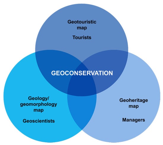
Figure 1.
Geoconservation relationships among agents (modified from [10]).
Over the past two decades, several quantitative and qualitative methods proposed how to classify geodiversity and geoheritage [11,12,13]. Due to their geographical nature and disciplinary novelty, geoheritage studies are more common in temperate regions than in tropical regions [14]. Despite the valuable efforts of UNESCO to develop geoparks, these have been limited mainly to temperate regions [15]. In Latin America, studies about geomorphosites have been increasing; however, they are scarce in Central America and they focus on volcanic landscapes, especially in Costa Rica [16]. Pérez-Umaña and Quesada-Román [17] studied the geomorphosites at Poás Volcano National Park, which is the most visited volcano in Central America. Similarly, Pérez-Umaña et al. [18] compared the geomorphosites of some volcanos: the Poás volcano in Costa Rica, the Paricutín volcano in Mexico, and the Teide-Pico Viejo volcano in the Canary Islands of Spain. Pérez-Umaña et al. [19] presented an integrated approach for the inventory and management of the geomorphological heritage of the Irazú Volcano National Park. Quesada-Román and Pérez-Umaña [20] studied the volcanic and paleoglacial geoheritage of the Miocene-Quaternary and the promotion of geotourism at Chirripó National Park in Costa Rica. Recently, Rosado-González et al. [21] indicated that three geoparks (Chirripó in Costa Rica, Tacaná between Mexico and Guatemala, and Río Coco in Nicaragua) and one initiative (Santa Rosa National Park, Costa Rica) are in progress in Central America.
Geotourism focuses on geological and geomorphological landscape characteristics. It builds close relationships between geodiversity, biodiversity, archaeological and cultural values, gastronomy, and/or architecture [22]. Over the last few decades, geotourism has increased worldwide as a useful tool to promote natural and cultural heritage that encourages the local and regional economic growth [23,24]. Currently, geotourism is mainly—but not uniquely—sponsored within the geoparks, but other regions also have significant geotourism potential; therefore, new assessments of geotourism resources in a particular area are important for the development of geotourism [25]. Geotourism constitutes one of the many applications of SDGs in geosciences [26]. UNESCO’s Global Geoparks are excellent opportunities to promote these territories as outdoor classrooms and to be incubators of sustainable development, sustainable lifestyles, appreciation of natural and cultural diversity, and the promotion of peace. Therefore, geotourism and geoparks prove effective for the promotion of the 17 United Nations SDGs of Agenda 2030 [15]. Sustainable tourism studies considering SDGs must encourage an equitable contribution of women initiatives, indigenous paradigms, the circular economy, ethical consumption and production, and local and sustainable governance [27].
National geoheritage studies are needed to illustrate potential regions assessing and evaluating their geodiversity. Some national assessments have been made in Spain [28], France [29], Mauritius [30], Chile [31], Ecuador [32], Costa Rica [33], and Cuba [34]. Therefore, improving geoheritage studies in tropical regions and developing countries is a priority to increase their income through geotourism and not affect their natural resources. This study hypothesizes that specific geomorphological conditions of low latitudes with intense rainfall and weathering rates, and strong anthropic pressures on their geo- and biodiversity, claim the importance of defining the concept of tropical geoheritage and promote its study. Hence, this study aims to (i) study the state of the art on geodiversity, geoconservation, and geotourism in Central America, (ii) identify and map the geodiversity of Central America (volcanic, coastal, karstic, glacial, and fluvial) on a regional scale, and (iii) identify the environmental, tourism, and protected areas’ policies in each country. The study becomes a baseline for geoheritage promotion in one of the less studied and developed regions of the world.
2. Materials and Methods
2.1. Geographical Setting
Central America is one of the most active seismic zones in the world due to the interaction of six tectonic plates (North America, Caribbean, Coco, Panama, Nazca, and South America) and its internal deformation [35]. The history of Central America began with the opening of a spreading center between North and South America sometime after about 170 Ma and more probably after 130 Ma, following the Late Triassic–Jurassic break-up of Pangaea [36]. The structural basis of Central America is broadly the destructive, convergent boundary between the Cocos and Caribbean tectonic plates, although it also involves three other plates: the Nazca, North, and South American plates [37]. The Central American isthmus has a relatively recent geological origin, although the precise timing of the formation of the region’s major landscape features is debated [38,39]. Historically, the most accepted hypothesis defends that the Isthmus of Panama closed relatively recently, around 3–4 million years ago (Ma) [40]. The Central American volcanic front (CAVF) contains approximately fifty active or potentially active edifices that are highly variable in height, volume, composition, and morphology [41]. These conditions have defined the geology that composes the region (Figure 2). The oldest rocks in Central America are Paleozoic metamorphic rocks and sediments in its northern section. Mesozoic oceanic basement and sediments are located mostly in southern Central America, while Tertiary intrusive and volcanic rocks and sediments are present along the isthmus. Quaternary volcanic rocks are present in recent volcanic areas, while Quaternary sediments filled wide sedimentary regions.
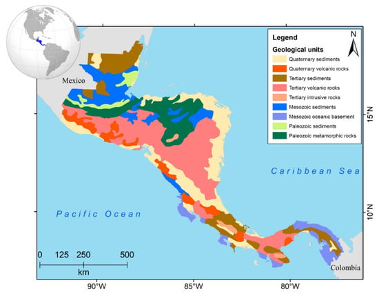
Figure 2.
Geological units from Central America (modified from [42]).
Central America can be divided into several major structural regions: the Maya-Yucatán, Motagua, Chortis, Nicaraguan, Chorotega, and Chocó blocks (Figure 3). These regions are defined by the interaction of the six tectonic plates in the region. The annual precipitation is normally higher than 1500 mm with some exceptions along the Pacific coast. The Caribbean basins normally are wetter, since there are more than 3000 mm every year. Temperatures are commonly up to 25 °C with certain fresh and cold zones due to altitude. Central America’s climatology is strongly modulated by the El Niño Southern Oscillation (dry/wet cycles), tropical cyclones, cold fronts, the Intertropical Convergence Zone shift, and trade winds in different spatiotemporal dynamics. Due to its tropical conditions, varied topography, and dense biodiversity, soils are highly weathered and prone to natural erosion processes. The main ecoregions are tropical moist forest, tropical seasonal moist forest, coniferous forest, tropical dry forest, mountain forest, and mangrove forest.
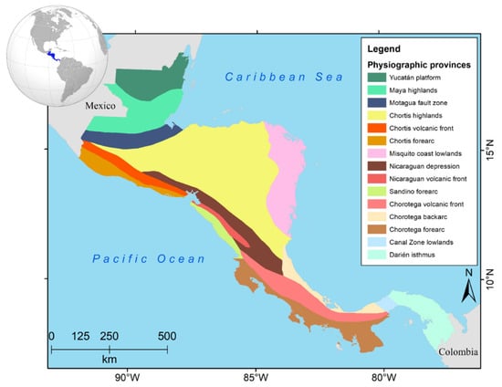
Figure 3.
Physiographic provinces of Central America (modified from [42]).
Central America is made up of seven countries: Guatemala, Belize, Honduras, El Salvador, Nicaragua, Costa Rica, and Panama. It has a continental area of 2,452,270 km2. Central America land uses normally comprise forests, croplands, and pastures, but the main urban centers have presented a rapid urban growth in the last five decades [43]. The region has almost 183 million inhabitants, a population density of 73 inhabitants per square kilometer, and 77.2% urban population.
2.2. Geodiversity Qualitative Characterization of Central America
This study analyzes the geodiversity of Central America using a qualitative method based on the existing cartography and information of the region [2,3]. The use of qualitative methods in geomorphology and assessing geodiversity have been applied in the past [11,44]. This study performed a mapping of the generalized geodiversity in Central America in two phases. Firstly, this study gathered existing geological, physiographic, and geomorphological maps i.e., [42,45,46], studies of geomorphological genesis, and Digital Elevation Models (DEMs). Secondly, we produced a small-scale geomorphological map within a Geographic Information System (ArcGIS 10.3) [47]. This study groups the geomorphic environments according to their genesis (volcanic, fluvial, coastal, karstic, and glacial). Our method gives, by the first time, an interesting picture of the region to characterize its geoheritage. Afterwards, the most promoted geosites in the region were gathered using existing touristic maps and webpages and national experts’ knowledge to fill a list of 393 geosites, which is given to the public in the Supplementary Material.
2.3. Environmental Policies Protecting Geoheritage in Central America
This study identified the protected areas and geosites that can protect and promote the geoheritage of the region [48,49]. Subsequently, an extensive literature review will be conducted on the environmental legislation of Central American countries in their early stages as well as on the international agreements in which the countries have participated [50,51,52]. This kind of methodology provides a historical reconstruction of the environmental conservation in the countries to understand how they have promoted the conservation of the geoheritage of the geoheritage in each country [53,54]. Consequently, we show the timeline of its environmental policies, its national conservation systems, and the tourism policies and actions of each nation [55]. Therefore, this initiative is based on the generation of baselines, indicators from the information of the countries in terms of their geoheritage and geodiversity that seek to articulate a strategy that includes the tourism sector, local and central governments, and academia from this proposal.
2.4. Central America Geotourism Platform
We used national tourism revenues by year to identify the macroeconomic changes that this sector has experimented from 1995 to 2018 in each country of the region [56]. This section can elucidate the impact of tourism in the region and how this existing platform can be used to promote the geodiversity and geoconservation in each country from a regional perspective.
3. Results
3.1. Geodiversity of Central America
Due to their tropical nature, fluvial environments dominate the geographical features of the Central American isthmus (Figure 4) with several water basins, lakes, and wetlands. The region catchments normally drain to the Pacific Ocean or the Caribbean Sea. The biggest catchments in the Pacific basin are Lempa, Tempisque, and Térraba, while in the Caribbean basin, the biggest catchments are Belize, Saarstoon, Motagua, Ulua, Patuca, Coco, Matagalpa, San Juan, Reventazón-Parismina, and Sixaola. Large lakes are located along the region in Guatemala (e.g., Atitlán, Amatitlán, Izabal), Belize (e.g., Challilo, Northern and Southern), El Salvador (e.g., Coatepeque, Ilopango, Olomega), Honduras (e.g., Yojoa, Caratasca, Tansin, Warunta; Figure 5b), Nicaragua (e.g., Xolotlán, Cocibolca), Costa Rica (e.g., Arenal), and Panama (e.g., Gatún, Bayano). Moreover, wetlands are common in the region, providing important ecological services as carbon sinks, water sources, coastal protection, and biodiversity refuges.
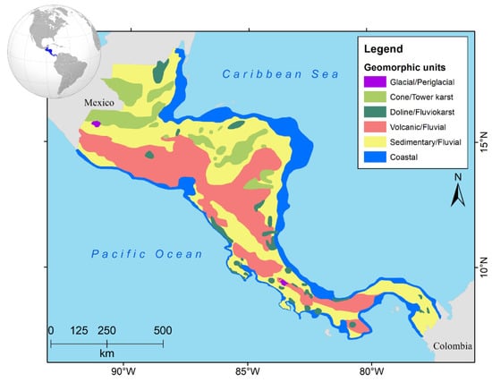
Figure 4.
Geomorphic units of Central America.
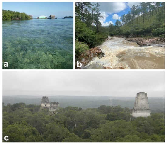
Figure 5.
(a) Bocas del Toro archipelago in Panama, (b) Fluvial landscapes of Honduras in El Paraiso Department, (c) Karstic flatlands in Tikal at northern Guatemala. Photos: Adolfo Quesada-Román (a,c) and Jainer Antonio Argeñal Umanzor (b).
Another important geomorphic environment in Central America is the volcanic landscape (Figure 4). The physiographic provinces indicate the distribution of these landscapes along the Chortis, Nicaraguan, and Chorotega volcanic fronts (Figure 3). Some examples of Central American volcanoes are Tacaná, Tajumulco, Atitlán, Fuego, Santa María, de Agua, and Pacaya (Guatemala); San Vicente, Chinameca, San Miguel, and Conchagua (El Salvador); Amapala (Honduras); Cosiguina, Cerro Negro, Telica, Masaya (Figure 6b), Momotombo, Mombacho, and Concepción (Nicaragua); Rincón de la Vieja, Tenorio, Miravalles, Arenal, Poás, Irazú, and Turrialba (Costa Rica), Barú, and La Yeguada (Panamá). Moreover, volcanic geomorphic environments comprise large mountain ranges with dozens of erosional and depositional landforms along the isthmus.
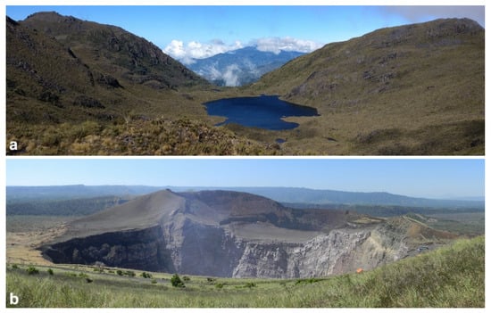
Figure 6.
(a) Glacial landscapes in Chirripó National Park in Costa Rica. (b) Masaya volcano in Nicaragua. Photos: Adolfo Quesada-Román.
The region features the Caribbean and Pacific coasts with plenty of landforms (Figure 4). Central America’s Pacific coasts are normally intricated and rocky, alternating with sandy beaches (pocket or large), deltas, estuaries, and rich ecosystems such as mangroves and coral reefs (the latter usually of small dimensions). The Caribbean coasts of the region are normally sandy, elongated, and eventually influenced by coral reefs (e.g., Mesoamerican Barrier Reef System, some islands, southern Costa Rica, Bocas del Toro—Figure 5a, and San Blas archipelagos in Panama), and large wetlands (estuarine, palustrine, and lacustrine), drawing the fluvial flatlands transition with the Caribbean Sea.
Karst environments are mostly in the north of the region but are present throughout the study area (Figure 4). Cone and tower karst are common in northern Central America, especially in Guatemala (Figure 5c) and Honduras, while doline karst is typical of small zones of Nicaragua, Costa Rica, and Panama. Among the common landforms in the region are karstic hills (cones, cockpit, and tower type), sinkholes, caves, and other subsidence or collapse structures such as underground rivers. Glacial landscapes are limited to certain areas of Guatemala and Costa Rica (Figure 4). The highest summits of Alto de los Cuchumatanes in Guatemala and Chirripó National Park in Costa Rica (Figure 6a) present erosional and depositional landforms derived from the glacial and periglacial during the Last Glacial Maximum (approximately 21 ka ago).
The regular geomorphic environments in Central America are volcanic, fluvial, coastal, karstic, and paleoglacial. Hence, the typical geosites are volcanic, fluvial, karstic, coastal, and archeological in origin (Table 1; Figure 7). We found that waterfalls are located along the isthmus, which is a regular feature due to its formation in mountain landscapes. Volcanoes and their features are common landforms that mostly border the Pacific coast with some exceptions. Attractive rivers sites were mostly found in Nicaragua, Honduras, and Guatemala, but these geosites are impressive along the whole isthmus. Natural reserves are common geosites in Guatemala, but they are related with protected areas that are extensively present in the region and even have well-established biological corridors. Mountains are common landforms in the region due to their tectonic and volcanic activity. Lakes and lagoons are common fluvial landforms mostly located in Nicaragua and northern Central America. Karst features such as caves and dolines are more common in northern Central America due to their older geological formations. Coastal geoforms are rich and diverse in the region. Archeological sites are mostly located in northern Central America due to their vast indigenous history related to important groups such as the Mayans.

Table 1.
Number of the most popular geosites type in Central America by country based on webpages, touristic maps, and internet-based research.
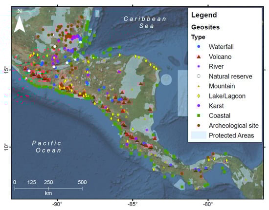
Figure 7.
Protected areas in Central America and relevant geosites in Central America based on maps, national reports, or websites about tourism in the region and every country.
3.2. Geoconservation State of the Art in Central America
During the early 1980s, the cultural heritage policies developed a better understanding of the valuable assets the region possesses and how they can promote them through science and local knowledge. From the early 1990s, the environment, climate change, protected areas, and wetlands laws were enacted regionally and nationally to protect their natural resources but mostly to manage them in a sustainable manner to encounter an equilibrium with local communities and private sector interests.
The decade of 1990 marks the official beginning of the wetlands’ protection in the region (Table 2). These ecosystems have been intensively altered during the last centuries in Central America due to the land use change and pollution. These environmental policies have substantially improved the status of these regional ecosystems. Wetlands such as lakes, lagoons, swamps, and mangroves provide immense potential for geoconservation and geotourism due to their great geo- and biodiversity. These environments have been favored by large wetlands territories protection along Central America (Figure 8).
Table 2.
Enactment year of the environmental, cultural heritage, and tourism policies in Central America.
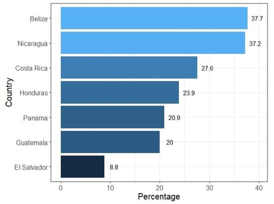
Figure 8.
Terrestrial protected areas by country (percentage of total land area in 2018).
3.3. Geotourism Basis in Central America
In Central America, different national policies were enacted to promote and organize the tourism sector in the last five decades. Some countries such as Costa Rica and Guatemala initiated a process that is widespread in the region nowadays (Table 2). The economic influence of tourism has a direct impact on the GDP percentage of the national economies of the region (Figure 9). The mean direct contribution of tourism in the region has been growing from roughly 3% in 1995 to 6% in 2018. Tourism represented almost 15% of Belize’s GDP in 2018, while it represented almost 3% for Guatemala. All countries showed a marked deacceleration after the economic crisis of 2008. Moreover, tourism promotes effective economic chains that involve transportation, accommodation, food, and entertainment in every possible scale, generating economic growth. The sustained economic growth tourism in the region is closely related to an environmental consciousness and compromise translated into natural, climatic change, and protected areas policies over the last few decades (Table 2).
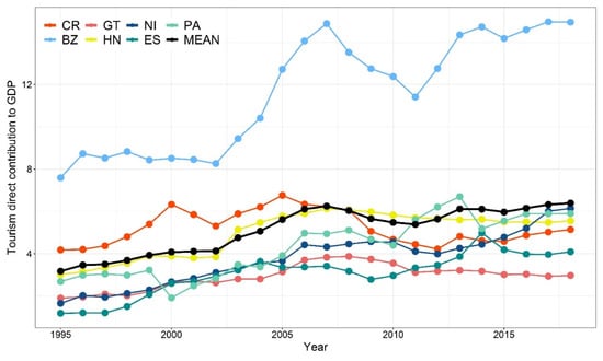
Figure 9.
Tourism direct percentage contribution to every national GDP from 1995 to 2018.
4. Discussion
4.1. Geodiversity Richness of Central America
We produced a geodiversity qualitative assessment that represents the different geomorphic units that compose Central America and gives a regional perspective of its geodynamics [57]. Due to their tropical nature, fluvial environments dominate the geographical features of the Central American isthmus with several water basins, lakes, and wetlands [42,46]. These environments are key for human activities, which are affected by droughts related with ENSO or extreme rainfall events due to the influence of tropical cyclones or cold fronts. Most of the population is located near rivers, lakes, and wetlands producing a continuous pressure on their ecosystems despite their importance. Another important geomorphic environment in Central America is the volcanic landscape [41]. These landscapes have a key function in fertile soils for agriculture, underground water recharge, human settlements, and tourism, especially in mountain regions. Nonetheless, volcanic active regions can be hazardous as have been seen in the region in the past.
The region features the Caribbean and Pacific coasts with plenty of landforms [58,59]. Pacific coasts present several deltas with extensive mangrove forests, elongated and pocket beaches, and impressive landforms such as arches, spits, tombolos, islands, bays, and gulfs. Caribbean coasts present elongated beaches, extensive lagoons and bars, massive coral reefs, and archipelagos. Karst environments are mostly in the north of the region but are present throughout the study area [60]. Karst in Central America is normally located in large mountainous systems and caverns, where a wide variety of erosional and depositional landforms appear. Glacial landscapes are limited to certain areas of Guatemala and Costa Rica [61]. The highest summits of Alto de los Cuchumatanes in Guatemala [62] and Chirripó National Park in Costa Rica [63,64,65] present erosional and depositional landforms derived from the glacial and periglacial during the Last Glacial Maximum (approximately 21 ka ago).
4.2. Geoconservation Potential of Central America
The extensive protected areas and environment laws in Central America have favored indirectly a tremendous platform to promote continental and marine geoconservation [66,67,68,69,70]. Moreover, these national protection systems have a well-established system of biological corridors [71]. These protected areas must consider and enhance their promotion through the rich cultural and indigenous knowledge present in Central America [72,73]. Moreover, these protected areas can be turned into geoparks to promote their spectacular geosites even more [74]. Nonetheless, community-based initiatives can lead to the creation of new geoparks. In 2017, Chirripó (Costa Rica) and Rio Coco (Nicaragua) applied to become UNESCO Global Geoparks [75]. Rio Coco is the first geopark in Central America; since July 2020, it has acquired 12 geosites with geological, aesthetic, and cultural values to promote sustainable tourism, education, and research [76]. Other studies in Costa Rica have conducted geoheritage inventories and evaluations as baselines to create geoparks in Poás and Irazú volcanoes [18,19] and Chirripó [20], which became national parks many decades ago.
Geoheritage conservation, the task of safeguarding and managing our most valued geological, geomorphological, hydrological, soil, and paleontology sites, is a growing challenge worldwide [77,78]. Central America’s society is fortunate to live in a geodiverse region, since this brings a huge range of benefits [79]. We must be clear in indicating that these are only reported as common interesting touristic places and geosites that can be taken into consideration for future geoheritage assessments. It is highly probable that by increasing the analysis scale, more impressive geosites will emerge in every country, region, and locality [57]. Only the expansion of geoheritage studies at different scales inside every country of Central America will provide better analyses and inventories that can eventually result in increasing revenues for the local communities [80,81].
4.3. Prospective Geotourism for Central America
From the mid-1990s to 2012, the annual economic indicators per country showed that international tourism had a highly significant impact on the Gross Domestic Product (GDP) per capita and a positive impact on the economic development of the region [82]. Moreover, Central America has demonstrated a higher efficiency than other regions in the world, securing larger shares of tourist arrivals [83]. The promotion of geotourism through protected areas and popular natural attractions will increase socioeconomic, cultural, and environmental knowledge and promotion of the actions taken at municipalities. Municipalities should ensure the well-being and opportunities of their inhabitants. Accessibility is linked to the possibility to reach unique geological and geomorphological features, is an important property of the Central American geosites, and is commonly considered in their assessment [84]. Moreover, geoheritage must be promoted and taught through informative panels, brochures, and easy-access key data [85]. Therefore, territorial governance must include geoconservation studies to protect their geoheritage and promote it through geotourism.
5. Conclusions
Central America is a dynamic region with a vast tectonic, volcanic, climatic, geomorphic, and ecological diversity framed in a rich cultural coupling. This study reviewed the geophysical framework that poses the Central American isthmus as a potential hotspot of geoheritage studies in the coming years. The most common geomorphic environments in the region are volcanic, fluvial, coastal, karstic, and paleoglacial. Therefore, the usual geosites are volcanic, fluvial, karstic, coastal, and archeological in origin.
It is necessary to produce more exhaustive analyses in every country to enhance the knowledge of the geodiversity (at better scales and local studies) as well as their environmental and touristic policies. International scientists in close collaboration with local experts should develop these studies to promote the application of new methodologies promoting the geoheritage potential of the region. Present and future protected areas in Central America must be used to enhance geoconservation as geoparks and, eventually, through geotourism, which will increase revenues at national, regional, and local scales.
Supplementary Materials
The following supporting information can be downloaded at: https://www.mdpi.com/article/10.3390/land11010048/s1, File S1.
Author Contributions
Conceptualization, A.Q.-R.; methodology, A.Q.-R.; software, A.Q.-R.; validation, L.T.-B., G.V.-E., M.A.R.-Á., M.R.-M., J.T. and C.E.-V.; formal analysis, A.Q.-R.; investigation, A.Q.-R., H.R.-B. and G.V.-E.; resources, G.V.-E., L.T.-B. and C.E.-V.; data curation, A.Q.-R. and H.R.-B.; writing—original draft preparation, A.Q.-R.; writing—review and editing, L.T.-B., G.V.-E., M.A.R.-Á., M.R.-M., J.T. and C.E.-V.; visualization, A.Q.-R.; supervision, A.Q.-R.; project administration, A.Q.-R.; funding acquisition, A.Q.-R., L.T.-B., G.V.-E., M.A.R.-Á., M.R.-M., J.T. and C.E.-V. All authors have read and agreed to the published version of the manuscript.
Funding
This research was funded by the PAN AMERICAN INSTITUTE OF GEOGRAPHY AND HISTORY, grant number GEO 02 and GEOF 03, 2021.
Acknowledgments
Special thanks to Soll Kracher for detailed English style and morphosyntax revision.
Conflicts of Interest
The authors declare no conflict of interest.
References
- Wang, L.; Tian, M.; Wang, L. Geodiversity, geoconservation and geotourism in Hong Kong global geopark of China. Proc. Geol. Assoc. 2015, 126, 426–437. [Google Scholar] [CrossRef]
- Gray, M. Geodiversity: Valuing and Conserving Abiotic Nature, 2nd ed.; Wiley-Blackwell: Hoboken, NJ, USA, 2013; pp. 3–14. [Google Scholar]
- Serrano, E.; Ruiz-Flaño, P. Geodiversity: A theoretical and applied concept. Geogr. Helv. 2007, 62, 140–147. [Google Scholar] [CrossRef]
- Zwolinski, Z. Geodiversity. In Encyclopedia of Geomorphology; Goudie, A.S., Ed.; Routledge: Oxfordshire, UK, 2004; Volume 1, pp. 417–418. [Google Scholar]
- Castree, N. Earth system science. In The International Encyclopedia of Geography; John Wiley & Sons: Hoboken, NJ, USA, 2019. [Google Scholar] [CrossRef]
- Reynard, E.; Brilha, J. Geoheritage: A multidisciplinary and applied research topic. In Geoheritage; Reynard, E., Brilha, J., Eds.; Elsevier: Amsterdam, The Netherlands, 2018; pp. 3–9. [Google Scholar]
- Gordon, J.E. Geoconservation principles and protected area management. Int. J. Geoheritage. 2019, 7, 199–210. [Google Scholar] [CrossRef]
- Newsome, D.; Dowling, R. Geoheritage and geotourism. In Geoheritage; Reynard, E., Brilha, J., Eds.; Elsevier: Amsterdam, The Netherlands, 2018; pp. 305–321. [Google Scholar]
- Gordon, J.E.; Crofts, R.; Díaz-Martínez, E.; Woo, K. Enhancing the role of geoconservation in protected area management and nature conservation. Geoheritage 2018, 10, 191–203. [Google Scholar] [CrossRef]
- Duval, V.S.; Gil, V.; Campo, A.M. La Cartografía como Instrumento de Geoconservación en Áreas Protegidas. Anu. Inst. Geociênc. 2020, 43, 345–353. [Google Scholar] [CrossRef]
- Zwolinski, Z.; Najwer, A.; Giardino, M. Methods for assessing geodiversity. In Geoheritage; Reynard, E., Brilha, J., Eds.; Elsevier: Amsterdam, The Netherlands, 2018; pp. 27–52. [Google Scholar]
- Mucivuna, V.; Reynard, E.; Garcia, M. Geomorphosites Assessment Methods: Comparative Analysis and Typology. Geoheritage 2019, 11, 1799–1815. [Google Scholar] [CrossRef]
- Santos, D.S.; Mansur, K.L.; Seoane, J.C.; Mucivuna, V.C.; Reynard, E. Methodological Proposal for the Inventory and Assessment of Geomorphosites: An Integrated Approach focused on Territorial Management and Geoconservation. Environ. Manag. 2020, 66, 476–497. [Google Scholar] [CrossRef]
- Migón, P. Geoheritage and world heritage sites. In Geoheritage; Reynard, E., Brilha, J., Eds.; Elsevier: Amsterdam, The Netherlands, 2018; pp. 237–249. [Google Scholar]
- Catana, M.; Brilha, J. The Role of UNESCO Global Geoparks in Promoting Geosciences Education for Sustainability. Geoheritage 2020, 12, 1–10. [Google Scholar] [CrossRef]
- Brilha, J. Geoheritage and geoparks. In Geoheritage; Reynard, E., Brilha, J., Eds.; Elsevier: Amsterdam, The Netherlands, 2018; pp. 323–335. [Google Scholar]
- Pérez-Umaña, D.; Quesada-Román, A. Metodología para la valoración y evaluación de geomorfositios en Costa Rica. Rev. Geogr. Am. Cent. 2018, 60, 117–135. [Google Scholar] [CrossRef]
- Pérez-Umaña, D.; Quesada-Román, A.; De Jesús-Rojas, J.; Zamorano-Orozco, J.; Dóniz-Páez, J.; Becerra-Ramírez, R. Comparative analysis of geomorphosites in volcanoes of Costa Rica, Mexico, and Spain. Geoheritage 2019, 11, 545–559. [Google Scholar] [CrossRef]
- Pérez-Umaña, D.; Quesada-Román, A.; Tefogoum, G. Geomorphological heritage inventory of Irazú Volcano, Costa Rica. Int. J. Geoheritage Parks 2020, 8, 31–47. [Google Scholar] [CrossRef]
- Quesada-Román, A.; Pérez-Umaña, D. Tropical paleoglacial geoheritage inventory for geotourism management of Chirripó National Park, Costa Rica. Geoheritage 2020, 12, 58. [Google Scholar] [CrossRef]
- Rosado-González, E.M.; Sá, A.A.; Palacio-Prieto, J.L. UNESCO Global Geoparks in Latin America and the Caribbean, and Their Contribution to Agenda 2030 Sustainable Development Goals. Geoheritage 2020, 12, 1–15. [Google Scholar] [CrossRef]
- Dowling, R.; Newsome, D. Geotourism: Definition, characteristics and international perspectives. In Handbook of Geotourism; Dowling, R., Newsome, D., Eds.; Edward Elgar: Cheltenham, UK, 2018; pp. 1–22. [Google Scholar]
- Pralong, J.P. A method for assessing tourist potential and use of geomorphological sites. Geomorphol. Relief Process. Environ. 2005, 1, 189–196. [Google Scholar] [CrossRef]
- Gordon, J.E. Geoheritage, geotourism and the cultural landscape: Enhancing the visitor experience and promoting geoconservation. Geosciences 2018, 8, 136. [Google Scholar] [CrossRef]
- Kubalíková, L. Assessing Geotourism Resources on a Local Level: A Case Study from Southern Moravia (Czech Republic). Resources 2019, 8, 150. [Google Scholar] [CrossRef]
- Gill, J.C. Geology, and the sustainable development goals. Episodes 2017, 40, 70–76. [Google Scholar] [CrossRef]
- Boluk, K.A.; Cavaliere, C.T.; Higgins-Desbiolles, F. A critical framework for interrogating the United Nations Sustainable Development Goals 2030 Agenda in tourism. J. Sustain. Tour. 2019, 27, 847–864. [Google Scholar] [CrossRef]
- Carcavilla, L.; Durán, J.; García-Cortés, Á.; López-Martínez, J. Geological heritage and geoconservation in Spain: Past, present, and future. Geoheritage 2009, 1, 75. [Google Scholar] [CrossRef]
- De Wever, P.; Alterio, I.; Egoroff, G.; Cornée, A.; Bobrowsky, P.; Collin, G.; Duranthon, F.; Hill, W.; Lalanne, A.; Page, K. Geoheritage, a national inventory in France. Geoheritage 2015, 7, 205–247. [Google Scholar] [CrossRef]
- Newsome, D.; Johnson, C.P. Potential geotourism and the prospect of raising awareness about geoheritage and environment on Mauritius. Geoheritage 2013, 5, 1–9. [Google Scholar] [CrossRef]
- Benado, J.; Hervé, F.; Schilling, M.; Brilha, J. Geoconservation in Chile: State of the art and analysis. Geoheritage 2019, 11, 793–807. [Google Scholar] [CrossRef]
- Sánchez-Cortez, J. Conservation of geoheritage in Ecuador: Situation and perspectives. Int. J. Geoherit. 2019, 7, 91–101. [Google Scholar] [CrossRef]
- Quesada-Román, A.; Pérez-Umaña, D. State of the Art of Geodiversity, Geoconservation, and Geotourism in Costa Rica. Geosciences 2020, 10, 211. [Google Scholar] [CrossRef]
- Corvea, J.L.; Gutiérrez, R.; Pascual-Aguilar, J.A.; De Bustamante, I.; Blanco, A. Geoheritage Integration in the Management of the Cuban Protected Areas. Geoheritage 2020, 12, 67. [Google Scholar] [CrossRef]
- Alvarado, G.E.; Benito, B.; Staller, A.; Climent, A.; Camacho, E.; Rojas, W.; Marroquín, G.; Molina, E.; Talavera, E.; Martínez-Cuevas, S.; et al. The new Central American seismic hazard zonation: Mutual consensus based on up to day seismotectonic framework. Tectonophysics 2017, 721, 462–476. [Google Scholar] [CrossRef]
- Bundschuh, J.; Winograd, M.; Dat, M.; Alvarado, G.E. Geographical, social, economic, and environmental framework and developments. In Central America: Geology, Resources and Hazards; Bundschuc, J., Alvarado, G.E., Eds.; T&F: Tokyo, Japan, 2007; p. 1436. [Google Scholar]
- Bundschuh, J.; Alvarado, G.E. (Eds.) Central America: Geology, Resources and Hazards; CRC Press: Boca Raton, FL, USA, 2012. [Google Scholar]
- Montes, C.; Cardona, A.; McFadden, R.; Morón, S.E.; Silva, C.A.; Restrepo-Moreno, S.; Ramirez, D.; Hoyos, N.; Wilson, J.S.; Farris, D.; et al. Evidence for middle Eocene and younger land emergence in central Panama: Implications for Isthmus closure. Geol. Soc. Am. Bull. 2012, 124, 780–799. [Google Scholar] [CrossRef]
- O’Dea, A.; Lessios, H.A.; Coates, A.G.; Eytan, R.I.; Restrepo-Moreno, S.A.; Cione, A.L.; Collins, L.S.; de Queiroz, A.; Farris, D.W.; Norris, R.D.; et al. Formation of the Isthmus of Panama. Sci. Adv. 2016, 2, e1600883. [Google Scholar] [CrossRef] [PubMed]
- Coates, A.G.; Jackson, J.B.C.; Collins, L.S.; Cronin, T.M.; Dowtsett, H.J.; Bybell, L.M.; Jung, P.; Obando, J.A. Closure of the Isthmus of Panama: The near-shore marine record of Costa Rica and western Panama. Geol. Soc. Am. Bull. 1992, 104, 814–828. [Google Scholar] [CrossRef]
- Van Wyk de Vries, B.; Grosse, P.; Alvarado, G.E. Volcanism and volcanic landforms. In Central America: Geology, Resources and hazards; Bundschuc, J., Alvarado, G.E., Eds.; T&F: Tokyo, Japan, 2007; p. 1436. [Google Scholar]
- Marshall, J. The geomorphology and physiographic provinces of Central America. In Central America: Geology, Resources and hazards; Bundschuc, J., Alvarado, G.E., Eds.; T&F: Tokyo, Japan, 2007; p. 1436. [Google Scholar]
- Vargas-Bolaños, C.; Orozco-Montoya, R.; Vargas-Hernández, A.; Aguilar-Arias, J. Metodología para la determinación del crecimiento de la mancha urbana en las capitales de la región centroamericana (1975–1995–2014). Rev. Geogr. Am. Cent. 2020, 1, 59–91. [Google Scholar] [CrossRef]
- Panizza, M. The geomorphodiversity of the Dolomites (Italy): A key of geoheritage assessment. Geoheritage 2009, 1, 33–42. [Google Scholar] [CrossRef]
- Bundschuh, J.; Birkle, P.; Finch, R.C.; Day, M.; Romero, J.; Paniagua, S.; Alvarado, G.E.; Bhattacharya, P.; Tippman, K.; Chaves, D. Geology-related tourism for sustainable development. In Central America: Geology, Resources and Hazards; Bundschuc, J., Alvarado, G.E., Eds.; T&F: Tokyo, Japan, 2007; p. 1436. [Google Scholar]
- Bergoeing, J.P. Geomorphology of Central America: A Syngenetic Perspective; Elsevier: Amsterdam, The Netherlands, 2015. [Google Scholar]
- Smith, M.; Paron, P.; Griffiths, J. Geomorphological Mapping: Methods and Applications; Elsevier: Amsterdam, The Netherlands, 2011; Volume 15. [Google Scholar]
- World Bank. Terrestrial Protected Areas (% of Total Land Area). 2018. Available online: https://data.worldbank.org/indicator/ER.LND.PTLD.ZS? (accessed on 1 December 2021).
- UNEP-WCMC and IUCN. Protected Planet: The World Database on Protected Areas (WDPA)/The Global Database on Protected Areas Management Effectiveness (GD-PAME) [On-Line], [November/2021]; UNEP-WCMC and IUCN: Cambridge, UK, 2021; Available online: www.protectedplanet.net (accessed on 1 December 2021).
- Herrera-Franco, G.; Montalván-Burbano, N.; Carrión-Mero, P.; Apolo-Masache, B.; Jaya-Montalvo, M. Research trends in geotourism: A bibliometric analysis using the scopus database. Geosciences 2020, 10, 379. [Google Scholar] [CrossRef]
- Herrera-Franco, G.; Montalván-Burbano, N.; Carrión-Mero, P.; Jaya-Montalvo, M.; Gurumendi-Noriega, M. Worldwide research on geoparks through bibliometric analysis. Sustainability 2021, 13, 1175. [Google Scholar] [CrossRef]
- Ólafsdóttir, R.; Tverijonaite, E. Geotourism: A systematic literature review. Geosciences 2018, 8, 234. [Google Scholar] [CrossRef]
- Gordon, J.E.; Crofts, R.; Díaz-Martínez, E. Geoheritage conservation and environmental policies: Retrospect and prospect. In Geoheritage; Elsevier: Amsterdam, The Netherlands, 2020; pp. 213–235. [Google Scholar]
- Ibáñez, J.J.; Brevik, E.C.; Cerdà, A. Geodiversity and geoheritage: Detecting scientific and geographic biases and gaps through a bibliometric study. Sci. Total Environ. 2019, 659, 1032–1044. [Google Scholar] [CrossRef] [PubMed]
- Farsani, N.T.; Coelho, C.; Costa, C. Geotourism and geoparks as novel strategies for socio-economic development in rural areas. Int. J. Tour. Res. 2011, 13, 68–81. [Google Scholar] [CrossRef]
- World Travel & Tourism Council. Annual Research: Key Highlights by Country; World Travel & Tourism Council: London, UK, 2019. [Google Scholar]
- Brilha, J.; Gray, M.; Pereira, D.I.; Pereira, P. Geodiversity: An integrative review as a contribution to the sustainable management of the whole of nature. Environ. Sci. Policy 2018, 86, 19–28. [Google Scholar] [CrossRef]
- Cortés, J. Coastal morphology and coral reefs. In Central America: Geology, Resources and Hazards; Bundschuc, J., Alvarado, G.E., Eds.; T&F: Tokyo, Japan, 2007; p. 1436. [Google Scholar]
- Naranjo-Arriola, A. Tourist carrying capacity as a sustainability management tool for coral reefs in Caño Island Biological Reserve, Costa Rica. Ocean Coast Manag. 2021, 212, 105857. [Google Scholar] [CrossRef]
- Day, M. Karst landscapes. In Central America: Geology, Resources and Hazards; Bundschuc, J., Alvarado, G.E., Eds.; T&F: Tokyo, Japan, 2007; p. 1436. [Google Scholar]
- Lachniet, M.S.; Roy, A.J. Costa rica and guatemala. In Developments in Quaternary Sciences; Elsevier: Amsterdam, The Netherlands, 2011; Volume 15, pp. 843–848. [Google Scholar]
- Roy, A.J.; Lachniet, M.S. Late Quaternary glaciation and equilibrium-line altitudes of the Mayan Ice Cap, Guatemala, Central America. Quat. Res. 2010, 74, 1–7. [Google Scholar] [CrossRef]
- Quesada-Román, A.; Stoffel, M.; Ballesteros-Cánovas, J.A.; Zamorano-Orozco, J.J. Glacial geomorphology of the Chirripó National Park, Costa Rica. J. Maps. 2019, 15, 538–545. [Google Scholar] [CrossRef]
- Quesada-Román, A.; Campos, N.; Alcalá-Reygosa, J.; Granados-Bolaños, S. Equilibrium-line altitude and temperature reconstructions during the Last Glacial Maximum in Chirripó National Park, Costa Rica. J. S. Am. Earth Sci. 2020, 100, 102576. [Google Scholar] [CrossRef]
- Quesada-Román, A.; Campos, N.; Granados-Bolaños, S. Tropical glacier reconstructions during the Last Glacial Maximum in Costa Rica. Rev. Mex. Cienc. Geol. 2021, 38, 55–64. [Google Scholar] [CrossRef]
- Pfeffer, M.J.; Schelhas, J.W.; Meola, C. Environmental globalization, organizational form, and expected benefits from protected areas in Central America. Rural Sociol. 2006, 71, 429–450. [Google Scholar] [CrossRef][Green Version]
- Saura, S.; Bastin, L.; Battistella, L.; Mandrici, A.; Dubois, G. Protected areas in the world’s ecoregions: How well connected are they? Ecol. Indic. 2017, 76, 144–158. [Google Scholar] [CrossRef]
- Acuña-Piedra, J.F.; Quesada-Román, A. Multidecadal biogeomorphic dynamics of a deltaic mangrove forest in Costa Rica. Ocean Coast Manag. 2021, 211, 105770. [Google Scholar] [CrossRef]
- De Lacerda, L.D.; Borges, R.; Ferreira, A.C. Neotropical mangroves: Conservation and sustainable use in a scenario of global climate change. Aquat Conserv. 2019, 29, 1347–1364. [Google Scholar] [CrossRef]
- López-Angarita, J.; Tilley, A.; Hawkins, J.P.; Pedraza, C.; Roberts, C.M. Land use patterns and influences of protected areas on mangroves of the eastern tropical Pacific. Biol. Conserv. 2018, 227, 82–91. [Google Scholar] [CrossRef]
- DeClerck, F.A.; Chazdon, R.; Holl, K.D.; Milder, J.C.; Finegan, B.; Martinez-Salinas, A.; Imbach, P.; Canet, L.; Ramos, Z. Biodiversity conservation in human-modified landscapes of Mesoamerica: Past, present and future. Biol. Conserv. 2010, 143, 2301–2313. [Google Scholar] [CrossRef]
- Booth, J.A. Understanding Central America; Westview Press: Boulder, CO, USA, 2011. [Google Scholar]
- McAnany, P.A. Maya Cultural Heritage: How Archaeologists and Indigenous Communities Engage the Past; RLPG: Lanham, MD, USA, 2016. [Google Scholar]
- Pál, M.; Albert, G. Comparison of geotourism assessment models: And experiment in Bakony–Balaton UNSECO Global Geopark, Hungary. Acta Geoturistica 2018, 9, 1–13. [Google Scholar] [CrossRef]
- Rosado-González, E.M.; Palacio-Prieto, J.L.; Sá, A.A. Geotourism in Latin America and Caribbean UNESCO global geoparks: Contribution for sustainable development goals. In Technological Progress, Inequality and Entrepreneurship; Springer: Cham, Denmark, 2020; pp. 107–121. [Google Scholar]
- UNESCO. Global Geoparks. 2021. Available online: https://unesdoc.unesco.org/ark:/48223/pf0000377255 (accessed on 1 December 2021).
- Prosser, C.; Murphy, M.; Larwood, J. Geological Conservation: A Guide to Good Practice; English Nature: Peterborough, UK, 2006; Volume 145. [Google Scholar]
- Gordon, J.E.; Crofts, R.; Gray, M.; Tormey, D. Including geoconservation in the management of protected and conserved areas matters for all of nature and people. Int. J. Geoheritage. 2021, 9, 323–334. [Google Scholar] [CrossRef]
- Gray, M. The confused position of the geosciences within the “natural capital” and “ecosystem services” approaches. Ecosyst. Serv. 2018, 34, 106–112. [Google Scholar] [CrossRef]
- Gray, M. Geodiversity, geoheritage and geoconservation for society. Int. J. Geoherit. 2019, 7, 226–236. [Google Scholar] [CrossRef]
- Gray, M. Geodiversity: A significant, multi-faceted and evolving, geoscientific paradigm rather than a redundant term. Proc. Geol. Assoc. 2021, 132, 605–619. [Google Scholar] [CrossRef]
- Gunter, U.; Ceddia, M.G.; Tröster, B. International ecotourism and economic development in Central America and the Caribbean. J. Sustain. Tour. 2017, 25, 43–60. [Google Scholar] [CrossRef]
- Dogru, T.; Suess, C.; Sirakaya-Turk, E. Why do some countries prosper more in tourism than others? Global competitiveness of tourism development. J. Hosp. Tour. Res. 2021, 45, 215–256. [Google Scholar] [CrossRef]
- Mikhailenko, A.V.; Ruban, D.A.; Ermolaev, V.A. Accessibility of geoheritage sites—A methodological proposal. Heritage 2021, 4, 1080–1091. [Google Scholar] [CrossRef]
- Bruno, B.C.; Wallace, A. Interpretive panels for geoheritage sites: Guidelines for design and evaluation. Geoheritage 2019, 11, 1315–1323. [Google Scholar] [CrossRef]
Publisher’s Note: MDPI stays neutral with regard to jurisdictional claims in published maps and institutional affiliations. |
© 2021 by the authors. Licensee MDPI, Basel, Switzerland. This article is an open access article distributed under the terms and conditions of the Creative Commons Attribution (CC BY) license (https://creativecommons.org/licenses/by/4.0/).