Abstract
A very noticeable increase in the beaver population (mainly the Eurasian beaver (Castor fiber L.)) in the East European Plain since the end of the 20th century through reintroduction contributed to the emergence of a large number of beaver dams and ponds, which resulted in the transformation of the channels and the hydrological regime of small rivers. In this paper, for the first time in the Middle Volga region, regularities in the distribution of beaver dams and ponds on small rivers were revealed based on a topographic survey of the river channel, regulated by beaver activity in recent decades. The materials of the paper were obtained during field (geodetic) work in August and September of 2022 in the valleys of two small rivers typical for the north of the Volga Upland, Morkváshinka River (16.6 km) and Morkváshka River (7.8 km), with subsequent statistical processing. According to the results obtained, all the dams we encountered were located in the sections of their channels with relatively small (up to 1%) and medium (1–3%) average gradients. In the upper reaches of the rivers, the expansion of beaver activity is limited to the large gradients of their channels. Along the entire length, there is an alternation of sectors with a “natural” (not regulated by beavers) channel and a cascade of beaver ponds. Drained (at the time of the survey) sectors without dams, as well as those with preserved and destroyed dams, were also identified on the Morkváshinka River. On the whole, 26–48% of the length of the studied rivers has been transformed by beaver activity. The average number of dams per kilometer of the watercourse is 3.7–5.1. The most favorable channel gradients for beaver activity are 3.6–16.6 m/km, or 0.36–1.66%. The average gradient of the channel, above which no beaver dams and related ponds were found in these rivers, is 30 m/km, or 3%. An increase in the channel gradient upstream of the rivers is reflected in the size of beaver dams and ponds. The beaver dams and ponds are slightly larger in the sections of the rivers with a relatively small average gradient than in the sections with a medium average gradient of the channel.
1. Introduction
An important feature of small rivers is the close relationship between runoff formation and the landscapes of their basins [1,2,3]. Therefore, all natural and anthropogenic processes occurring in the channels and catchment areas of small rivers are reflected primarily in their runoff of water, sediment, and dissolved substances. In recent decades, the small rivers of Eastern Europe have been significantly affected by the beaver (predominantly the Eurasian beaver (Castor fiber L.)), and these affects manifest themself in the construction of dams and related ponds. This results in a decrease in the velocity of flow, a decrease in water runoff, and the accumulation of sediment and related pollutants along the channels and floodplains of these rivers, as well as the transformation of their floodplain landscapes [4,5,6,7,8,9,10,11,12]. It is important to note that this often occurs in conjunction with the negative anthropogenic impact on small watercourses.
The last beaver on the territory of the modern Republic of Tatarstan, one of the administrative regions of the Middle Volga region of European Russia, where the studied rivers are located, was captured (killed by hunters) in 1902 [13]. In the middle of the 20th century, work on the reacclimatization of Castor fiber L. in the Middle Volga region began [12]. By that time, due to the poor forage base and partially drying watercourses, and the watersheds that were used mainly for arable land and pastures, the habitat conditions for the beaver were unfavorable [13]. Reintroduced beavers have since found suitable habitats. The increase in the number of reintroduced beavers has been especially intensive since the beginning of the 21st century, which is clearly shown in Figure 1. The reintroduction of beavers is a functionally new invasion [12]. The Castor fiber L. is no more a native species to a previously native ecosystem [14].
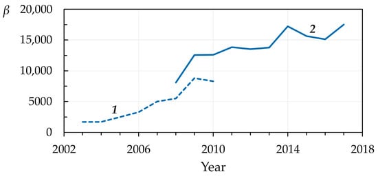
Figure 1.
Change in the number (β) of reintroduced beavers (Castor fiber L.) in the Republic of Tatarstan (67,847 km2) from 2003 to 2017. 1—according to the Federal Research Center for Development of Game Management. Available online (in Russian): http://www.ohotcontrol.ru (accessed on 22 May 2023); 2—according to the State Committee of the Republic of Tatarstan for biological resources. Available online (in Russian): https://ojm.tatarstan.ru (accessed on 22 May 2023). Note: It is noteworthy that in 1949, according to the first electronic source, there were only 52 beavers in the republic.
Increasing the beaver population and its construction activities in riverbeds sometimes also leads to underflooding and flooding of settlements, agricultural fields, and infrastructure facilities [15,16]. Considering the fact that a significant part of the population lives near small rivers [17], it becomes necessary to identify the role of beaver activity in changing the hydrological regime of small rivers and the quality of water and bottom sediments in them at different local and regional scales.
To assess the impact of beaver activity on the variability of water runoff, river sediments, and related pollutants, as well as the transformation of floodplain and channel complexes of small rivers, it is necessary, first of all, to understand the features of the distribution of the main objects of their “hydrotechnical” activity along rivers (dams and ponds). In addition, the sizes of these objects are necessary to assess the volumes of water and sediment accumulation in them. Therefore, at the first stage, geodetic work is carried out on the rivers, including topographic surveys of river channels. In recent decades, topographic surveys of natural objects have been carried out using high-precision electronic stations. This technology allows researchers to obtain high-resolution data on the relief of the Earth’s surface (DEM). This technique is used to study erosion-sedimentation processes [18,19], horizontal and vertical deformations of river channels [20,21], coastal/bank processes [22], landslides [23,24] and mudflows [25], the morphology of river valleys [26,27], seismically dangerous faults [28], volcanic landforms [29], and so on.
In topographic surveys, global navigation satellite system (GNSS) technologies are widely used, which makes it possible to determine quickly and with sufficiently high accuracy the geographical coordinates of objects and elevations. In recent years, this method has been widely used to obtain the coordinates of beaver settlements/huts [30,31] and to survey the ponds they have created [32].
In this work, for the first time in the forest-steppe zone of the Middle Volga region of the East European Plain and using the example of two small rivers with valleys typical for the north of the Volga Upland, one of the largest within the plain, the results of an analysis of the features of the distribution of beaver dams and ponds are presented based on a topographic survey of the channels of these rivers, which have been regulated by beaver activity in recent decades.
2. Materials and Methods
2.1. Study Area
Geodetic work was carried out in August and September 2022 in the valleys of the Morkváshinka and Morkváshka rivers (right tributaries of the Volga River (Figure 2), Verkhneuslonsky municipal district of the Republic of Tatarstan, European Russia)), which differ in the length and degree of anthropogenic transformation of the natural landscapes of their basins. The choice of these rivers was due to the fact that their valleys are geomorphologically typical of the northern extremity of the Volga Upland [33]. The total length of the Morkváshinka River, according to GNSS survey data, is 16.2 km (the total length, combined with one of the dry valleys in the upper reaches of the river, is 16.6 km); the length of the Morkváshka River is 7.4 km (7.8 km). The construction of man-made ponds in the middle reaches of these rivers and water intake for private households led to a significant decrease in water flow, especially during the summer and autumn low water period. High evaporation from the surface of beaver ponds also plays an important role in reducing runoff. This resulted in the appearance of sectors of the channel drained during the low water season (in the lower reaches of the Morkváshinka River) (Figure 3B). The appearance of runoff in certain sectors of the channels of this river during the summer-autumn low water period is mainly associated with the small lateral tributaries that unload groundwater during this time.
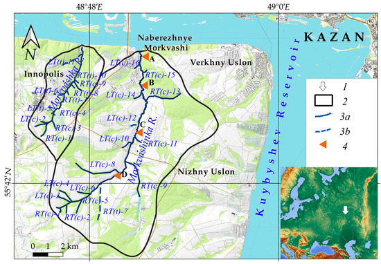
Figure 2.
The location of the Morkváshinka and Morkváshka rivers. 1—the position of the studied rivers in Europe, 2—the boundaries of the basins of the rivers, 3—watercourses (3a—permanent, 3b—temporary), 4—places of photographic fixation of the Morkváshinka riverbed (A, B, C, and D).
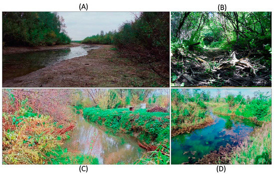
Figure 3.
Views of the Morkváshinka River (their locations are shown in Figure 2). (A)—the lower (near-estuary) reaches of the river, (B)—seasonally drained riverbed, upstream of Naberezhnye Morkvashi, (C)—the river near Lesnye Morkvashi, (D)—dammed part of the river, upstream of anthropogenic ponds (the photos were taken by the authors in August and October of 2022).
The water supply of both rivers is mixed, with a large predominance of snow. In that regard, the predominant value of the annual runoff of the studied rivers falls on the spring (snowmelt-induced) flood (March–April). The average long-term annual runoff depth in the river basins is 103 mm (https://tatarica.org/ru/razdely/priroda/gidrograficheskaya-set/reki/morkvashinka, accessed on 2 June 2023).
The valley of the Morkváshinka River is characterized by the asymmetry of its slopes. The right slope is steep and high for the most part; the left slope is relatively gentle. The steep right slope is composed of bedrocks—in the lower part, predominantly limestones of the Kazanian stage; in its upper part, the variegated rocks of the Urzhumian stage of the Upper Permian are overlain by thin brown deluvium loams with an abundance of crushed stone [33]. The left slope is composed of a thick layer of Late Pleistocene deluvium-solifluction loams with an interlayer of underdeveloped buried soil of the Middle Valdai age strongly disturbed by permafrost processes, in the middle part and with well-developed hydromorphic soil in the lower part [33]. The valley of the Morkváshka River is narrower, with slightly asymmetrical slopes composed of the same Upper Permian rocks overlain from above by a layer of Late Pleistocene deluvium-solifluction loams.
In the valleys of the studied rivers, the low (up to 0.5–0.7 m) (Figure 3A) and high (up to ≈1.5 m) floodplains are morphologically expressed in small fragments; the low (Early Holocene) river terrace (up to 4–5 m) is morphologically expressed in larger fragments [33]. The native vegetation is represented by linden-oak forests with an admixture of maple, beech, and elm (about 40% of the total area in the Morkváshinka River basin and 60% in the Morkváshka River basin) [34]. The basins of two rivers, except for the right steep slope of the valley of the Morkváshinka River in its lower reaches and the steep slopes of the Morkváshka River valley, are heavily modified by humans, which is expressed in the high plowing of their soils and the presence of settlements. At present, the floodplains of the rivers are heavily overgrown with willow as a result of the activity of beavers, and only some of their areas are used for pastures and hayfields.
2.2. Methods
The purpose of a topographic survey is to determine the most characteristic points that reflect the contours of the objects under study, the terrain and the bottom of the bodies of water. In geodesy, there are several types of terrain surveys. The choice of method depends on various factors: the scale of the survey, the size of the area under study, the terrain (forested, relatively flat or hilly, etc.), the availability of equipment, the timing of field work, and so on [35]. Currently, in topographic surveying, satellite positioning methods (for example, using a GNSS receiver) are widely used. Horizontal and elevation marks can be calculated using a GNSS receiver in static and kinematic modes. With satellite positioning, theoretically, at least four satellites should be observed. Positioning accuracy depends on the number and position of visible satellites. In some places, such as dense forests, gullies, small dry valleys, and river valleys, satellite signals may be either blocked or severely weakened by obstacles, and thus the number of visible satellites may not be sufficient to estimate the position of the receiver. The use of a combination of GPS/BeiDou/GLONASS/Galileo satellites contributes to solving the above problems [36,37].
The Trimble R12i GNSS receiver was chosen as the equipment for this type of survey because it supports all navigation satellites and is well suited to fairly dense forest cover. The main feature of this device is the inertial tilt compensation system, which makes it possible to take the tip of the GNSS pole as a reference point, which, in turn, allows researchers to obtain the coordinates of hard-to-reach, dangerous, or partially closed objects. There is no need to level the receiver, which increases the speed and productivity of field work. Sometimes, due to various interference, it may take longer to acquire some points to achieve the required accuracy.
The channels of the two studied rivers were surveyed in two modes (kinematics and radio RTK) depending on the presence of a GSM signal. With a good signal, one rover was used, which communicated with the KZN base station to receive corrections. However, for most of their length, the rivers were surveyed in Radio RTK mode, the main feature of which is the use of two receivers, one of which is a Trimble R10 “base station” and the second, a Trimble 12 (“rover”). The base station was used as a stationary device during the survey to continuously provide the mobile rover with measurement and correction information for post-processing and high-precision real-time positioning. At the beginning of the work, in an open area near the work site, the Trimble R10 was set up on a tripod. The Trimble R12 receiver was attached to the GNSS pole. A task was created in the Trimble Access program of the Trimble TSC5 controller, specifying the communication, elevation, and projection parameters. The corrections were transmitted over a radio channel with a frequency of 433 MHz (by default). The radio modems built into the basic receivers had a power of up to 4–5 W and were equipped with compact (up to 30 cm) antennas for operation over short distances. To increase the range, external radio modems with a power of up to 35–40 W were used with a separate power supply and larger antennas (up to several meters). When operating in radio mode, the standard deviation of the obtained coordinates averaged up to 15 mm in plan and up to 20 mm in height. The following parameters were measured by the GNSS receiver: the position and elevation of the channel and the water’s edge in the rivers, the elevation of the lower and upper reaches of the beaver dams, their width and their length. This method has been tested by various researchers ([30,31,32,38], etc.).
In office conditions, field data obtained during the topographic survey (horizontal and elevation marks) using GNSS equipment were loaded into the Trimble Business Center software, where they were processed (editing and equalization). In this case, the average adjustment error was 3 cm in plan and 7 cm in height. In the QGIS software, for each mark of the channel or water’s edge and position of the dams, as well as the lower and upper reaches of dams captured in the field, the distance from the mouth of the studied rivers were determined. When constructing the curves of the longitudinal profiles of the rivers, the values of the elevation of the water’s edge and the position of the dams were used, and for the drained sectors, the elevation of the channel. In addition, separate icons indicate the position of beaver dams and tributary mouths (permanent and temporary streams).
The longitudinal profile of the studied rivers consists of several bends, which make it possible to distinguish segments (sections) on them that differ in average gradient. For each of them, the length, the so-called “fall” (the difference between the maximum and minimum elevation in the section), average gradient (the ratio of the fall to the length of the section), the length of sectors within the section subjected to beaver activity, the number of dams, the density of dams (the ratio of the number of dams to the length of the section), and the distance between dams inside beaver colonies were determined.
3. Results
On the longitudinal profiles of the studied rivers built in the course of the topographic work, several sections were identified (Figure 4 and Figure 5), clearly distinguished by the gradient of their channels: (I) a section with relatively small average gradients (up to 1%), which covers the lower reaches and the lower part of the middle reaches of the Morkváshinka River; (II) sections with medium average gradients (1–3%), including the upper part of the middle reaches of the Morkváshinka River and the entire lower and middle reaches of the Morkváshka River; (III) sections with relatively large average gradients of the channel (more than 3%), the very upper reaches of these rivers. All these sections account for 71%, 23%, and 6% of the entire length of the Morkváshinka River, respectively (Figure 4).
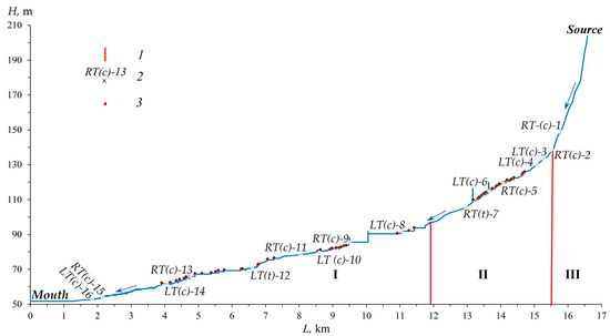
Figure 4.
The longitudinal profile of the Morkváshinka River. 1—the boundaries of the river channel sections: I is with the average gradient of <1%; II is with 1–3%, III is with >3%; 2–tributaries (RT—right tributary, LT—left tributary (c is a permanent stream, t is a temporary stream); 13, 14, 15… are ordinal numbers of the tributaries, the position of which is indicated in Figure 2), 3—beaver dams.
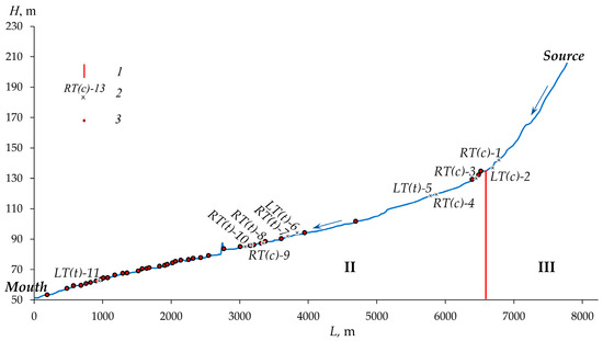
Figure 5.
The longitudinal profile of the Morkváshka River (for other symbols see Figure 4).
There is no section in the Morkváshka River channel with relatively small average gradients; sections with medium and large average gradients occupy 85% and 15% of the entire length of this river, respectively (Figure 5). This distribution of the channel gradients reflects well the general concave profile of similar small rivers in the study region.
The total length of the Morkváshinka riverbed dammed by beaver activity (operating and seasonally dry ponds) is 7.98 km (48%), “natural” (free from beaver activity)—8.6 km (52%), and on the Morkváshka River—2.05 km (26%) and 5.75 km (74%), respectively. In the sections of the Morkváshinka riverbed with relatively small and medium average gradients, beaver activity covers 34–35% (of the length of the sections), and with large slopes—0%; on the Morkváshka River—0% (this section is absent), beaver activity covers 31% and 0%, respectively (Figure 6).
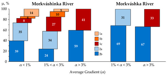
Figure 6.
The ratio (μ–the share) of dammed and non-dammed sectors of the Morkváshinka and Morkváshka rivers by different gradient (α) sections of their riverbeds. 1—drained riverbed sectors (1a is fragments of the riverbed previously occupied by beaver ponds (without operating dams), 1b is fragments of the riverbed previously occupied by beaver ponds (with operating dams), 1c is fragments of the riverbed without ponds), 2—flooded channel sectors (2a is with ponds, 2b is without ponds).
In the drained (at the time of work) sectors of the Morkvashinka River channel, in addition to the “natural” (not regulated by beaver activity) channel, composed of coarse alluvium (carbonate boulder-rubble material) (Figure 3B), former dammed (pond) sectors with abandoned and destroyed dams are also distinguished. They are identified by the presence of preserved relatively fine-grained pond silt with organic matter (in places up to 2 m thick or more). Such sectors occupy about 16% of the total length of the entire channel of the Morkváshinka River. On the Morkváshka River, drained sectors of the channel during the summer and autumn low water periods associated to some extent with beaver activity have not been identified, i.e., the river runoff was tracked along the entire river.
The total number of operating beaver dams along the entire channel of the Morkváshinka River is 61 units (Figure 7), and along the Morkváshka River 40 units (Figure 8). Moreover, all beaver dams are located in the sections of the channel with relatively small and medium gradients. Seven dams (12%) were identified on the drained (during the field work) sectors of the Morkváshinka riverbed. The average density of dams in the Morkváshinka River is 3.7 units/km; in the Morkváshka River, it is 5.1 units/km, varying from 0 to 7.6 units/km. The highest value is observed in the sections of the channels with medium (1–3%) average gradients. The average distance between dams within the beaver colonies along the Morkváshinka River in the section with a relatively small average gradient is 160 m, and in the section with a medium (1–3%) average gradient, it is 50 m. A similar picture is observed in the section with a medium (1–3%) average gradient of the Morkváshka River, where the distance between dams is 55 m. In general, on the Morkváshinka River, in the lower section of its channel, the sizes of ponds and dams are somewhat higher than in the middle reaches (Table 1). At the same time, most of the ponds are located in the riverbeds, and only a small part of them also occupies the low floodplains of the rivers.
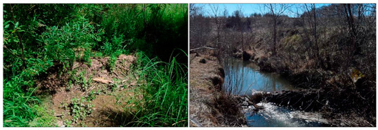
Figure 7.
One of the beaver dams on the Morkváshinka River in a drained (left; August 2022) and snowmelt-flooded (right; April 2023) state (the photos were taken by the authors).
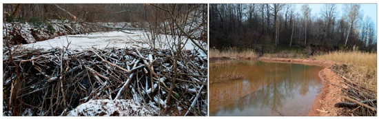
Figure 8.
Two different types of beaver dams on the Morkváshka River. One of them was photographed in November 2022 (left; typical (transverse) dam), the second–in April 2023 (right; sickle-shaped dam) (the photos were taken by the authors).

Table 1.
Morphometric parameters of some dams in different gradient sections of the channels of the Morkváshinka and Morkváshka rivers.
4. Discussion
Due to the strong anthropogenic impact and the influence of beaver activity, the longitudinal profiles of the studied rivers have a complex pattern of alternating sectors of the “natural” channel, anthropogenic and beaver ponds (in the form of separate steps in the longitudinal profiles). In addition, in the Morkváshinka River, there are sectors of a seasonally drained channel, composed of slightly rounded alluvial deposits formed before beaver activity, and sectors of a seasonally drained channel covered by sediments formed during the construction and functioning of beaver ponds (comparatively thick fine-grained material).
The length of the riverbed affected by beaver activity is 48% for the Morkváshinka River and 26% for the Morkváshka River. In general, about 1/3 of the length of the sections of the Morkváshinka riverbed with relatively small and medium average gradients was transformed by beaver activity. A similar picture is observed, for comparison, on small rivers of North America [39], where beaver dams and beaver pond sediments are an important structural element of the channel morphology, creating a stepping of its longitudinal profile [40].
The density of beaver dams on the Morkváshinka and Morkváshka rivers reaches its peak in the sections of their channels with a relatively moderate (medium) gradient (1–3%). In general, the average density of beaver dams both for the entire length of the studied rivers and for their individual sections matches the data for the territory of North America at 7–10 units/km [7,41,42].
Numerous studies have shown that the distribution of beaver dams is closely related to the gradient of the riverbed ([39,40,43,44], etc.). This relationship is also noted for the studied rivers, where the number of dams generally decreases upstream (Figure 9).
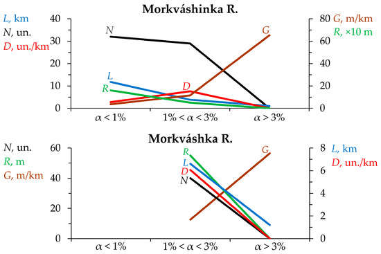
Figure 9.
The distribution of the studied beaver dams of the Morkváshinka and Morkváshka rivers by different gradient sections of their riverbeds. N—the number of dams, D—the average density of dams, R—the average distance between dams, L—section length, G—the average riverbed gradient.
However, due to the shorter length and close elevation of the source in comparison with the Morkváshinka River (with equal elevations of the mouth, the level of the Kuybyshev Reservoir, ≈53 m a.s.l.), the average gradient of the entire Morkváshka River is almost twice as high as that of the neighboring river. Therefore, along the channel of the Morkváshka River, no large section with a relatively small average gradient (less than 1%) is distinguished, except for the lowest two or three hundred meters of the near-estuary zone of the river. At the same time, in the sections of the studied rivers with a gradient of more than 30 m/km or 3%, beaver dams were not found. This is approximately 1.5–2.5 times less than the critical values of gradients that were previously obtained by other researchers [7,45]. The main reason for the relatively small critical (for the formation of dams) gradients of the channels of the studied rivers is probably related to their lengths and catchment areas, which primarily affect the water runoff in the upper reaches of the rivers. This issue requires further research.
It should be noted that the quantitative characteristics of the dams (average height and length) differ statistically (see Table 1) in the sections with relatively small and medium riverbed gradients. The height of most beaver dams on the studied rivers does not exceed 1.2 m, and their length is less than 10 m. Such a height and length of beaver dams is typical, for example, for small rivers in the USA [46], Sweden [47], and Poland [48]. The construction of dams by beavers in the upper reaches of small rivers is limited by natural factors, since, in this case, the dams should be quite high, which would require a large number of resources for their construction and maintenance in a normal (for beavers) condition. Otherwise, small dams will only result in the appearance of small ponds (up to a few meters long), which is very inefficient in terms of their suitability for the life of beavers. In addition, beavers are animals that live in families [49], and each family manages a fairly long sector of the river (4–5 individuals per 1 km of the river) [50], otherwise competition arises in the presence of frequent small ponds. It is noteworthy that in the Morkváshinka River, the average distance between large neighboring beaver colonies (the largest beaver settlements), which we identified in the amount of three (3.8–5.7, 8.5–9.5 and 13.2–14.8 km from the mouth along the horizontal line) is about 4.5–5 km (see Figure 4). This circumstance is most likely based on an ecological justification and requires further detailed study.
The average distance between beaver dams in the Morkváshinka River is 70 m; for the Morkváshka River, it is 53 m. The distance is significantly reduced from the lower reaches to the upper reaches of the rivers (in the Morkváshinka River). In general, on the studied small rivers, a decrease in the length and area of the ponds upstream is observed, which is primarily associated with the morphometry of the channel [40]. The parameters of the bottom of the river valley (the channel width, the presence of a floodplain and its morphometry) also play an important role [7].
It is important to understand that the influence of the river channel gradient on beaver activity is manifested both directly (see above) and indirectly. In the latter case, this manifests itself through the formation of the necessary permanent flow of water, sufficient for the functioning of beaver ponds throughout the year. When the incoming surface water runoff (together with incoming underground runoff) is less than the sum of the outgoing water balance elements (surface water runoff from the pond through the dam, evaporation from the surface of the pond, and filtration into its grounds), the sustainable functioning of beaver ponds is impossible. Such a stable runoff of water (its minimum values) is possible only when smaller streams from the upper links (small valleys with large gradients of their channel) merge into a single stream, which naturally also affects its smaller gradients. For example, this is observed well in the very upper reaches of the Morkváshka River.
As mentioned above and in many other studies, the results of beaver activity are reflected primarily in the hydrological regime of rivers through changes in the elements of the water balance. However, the geomorphological role of this rodent is also important. This role consists, for example, of the creation of riverbank burrows and canals and intensive sedimentation in a dammed channel and on the floodplain of small rivers. Beavers often construct several burrows within the same pond [51]. For example, along two seasonally drained ponds with a total length of about 200 m in the Morkváshinka River, we found several dozen such burrows of different internal volumes. When such burrows are created, a significant amount of sediment enters the riverbed [52,53]. In addition, riverbank burrows can collapse during snowmelt-induced or rainfall-induced floods, as well as under the influence of other external factors [54], thereby transforming the relief of both the channel and the floodplain. The creation of relatively high and long dams by beavers, which also occupy a low floodplain, sometimes leads to the appearance of multi-branch channels on them [51]. Such sites are distinguished on the studied rivers, for example, in the upper part of the middle course of the Morkváshinka River and in the middle course of the Morkváshka River. Sometimes beavers build dams in places where anthropogenic dams break or in the bottoms of drained anthropogenic ponds (see the right-side photo of Figure 8), creating a complex topography and forming a complex sequence of accumulation of anthropogenic and castorogenic (beaver-induced) sediments. We also encountered such phenomena in the bottoms of the studied river valleys. Large amounts of mineral and organic material are deposited in beaver ponds [5,10,40,55]. Butler and Malanson [56,57] estimated sediment accumulation rates from 2 to 39 cm yr−1 in some ponds in Montana. In Oregon, in the early years of the ponds of this state, the sedimentation rate was up to 47 cm yr−1, but after six years it decreased to 0.075 cm yr−1 [58]. In Germany, the average sedimentation rate was 6 cm yr−1 [59]. According to Butler and Malanson [5], the rate of sedimentation can vary by a factor of 10, even within the same river basin, and depend on the geological and geomorphological features of a particular area. The above and numerous other facts show the importance of studying beaver activity as an environment-forming, environment-transforming, ecological, and even societal factor in river valleys, primarily in the valleys of small rivers as one of the most environmentally vulnerable elements of the river network.
5. Limitations
Due to difficult transport accessibility (lack of access roads to different sectors of the studied river channels) and the laboriousness of surveying the channels with GNSS equipment in conditions of high forest cover and swampiness, the measurement of morphometric parameters in the bottoms of the valleys of the two studied rivers (floodplain height and width, channel width), as well as the height and the lengths of dams were carried out only in certain parts of the channels and still cannot be used to identify representative statistically significant relationships between the indicated and other parameters.
6. Conclusions
Topographic survey of two small rivers, Morkváshinka and Morkváshka, flowing in the north of the Volga Upland, made it possible to identify patterns in the distribution of beaver dams and associated ponds in them, which play an important environment-transforming role (including a role in hydrological and geomorphological change) in river valleys, primarily in the valleys of small rivers. One of the most important factors in the distribution of these objects in the valley bottoms of small rivers is the gradient of the river channel. Using the example of the longer Morkváshinka River, it is shown that the density of the beaver dams increases upstream of the river, while the length of the channel transformed by beaver activity and the distance between dams, as well as the sizes of the dams themselves (their height and length) and ponds, on the contrary, decrease in the same direction. In the upper reaches of the small rivers, the expansion of beaver activity is limited to the large gradients of their channels. The revealed regularities in the distribution of beaver dams and related ponds are generally typical not only of the small rivers of the study region, but also of the Upper Volga Lowland [4], Europe [51,60], and North America [42,61]. The results obtained are preliminary. In the future, it is planned to carry out research on other rivers of the Middle Volga region, the basins of which are located in different landscape zones and geomorphological conditions, and also differ in the degree of anthropogenic transformation of their natural landscapes.
Author Contributions
Conceptualization, A.V.G.; methodology, A.G.S., A.V.G. and O.A.L.; software, A.G.S.; validation, A.V.G. and A.G.S.; formal analysis, A.G.S. and A.V.G.; investigation, A.G.S., O.A.L. and A.V.G.; resources, A.G.S. and O.A.L.; data curation, A.G.S.; writing—original draft preparation, A.G.S. and A.V.G.; writing—review and editing, A.V.G. and A.A.B.; visualization, A.G.S. and A.V.G.; supervision, A.V.G.; project administration, A.G.S. and A.V.G.; funding acquisition, A.G.S. All authors have read and agreed to the published version of the manuscript.
Funding
This research was carried out at the expense of the grant of the Russian Science Foundation No. 22-77-10087, https://rscf.ru/project/22-77-10087/, accessed on 10 June 2023.
Institutional Review Board Statement
Not applicable.
Informed Consent Statement
Not applicable.
Data Availability Statement
The data presented are available on request from the corresponding author. The data are not publicly available due to privacy reasons.
Acknowledgments
The authors are grateful to M.Y. Karavanov and R.V. Zagretdinov for providing geodetic equipment and consultations in conducting topographic surveys using GNSS equipment, as well as to R.R. Khabibullin for participation in field work.
Conflicts of Interest
The authors declare no conflict of interest. The funders had no role in the design of the study; in the collection, analyses, or interpretation of data; in the writing of the manuscript; or in the decision to publish the results.
References
- Sajikumar, N.; Remya, R.S. Impact of land cover and land use change on runoff characteristics. J. Environ. Manag. 2015, 161, 460–468. [Google Scholar] [CrossRef]
- Gusarov, A.V. The main regularities of the ratio between riverbed and basin components of erosion and suspended sediment flux in the Northern Eurasia’s river basins. Geomorfologiya 2015, 4, 3–20. (In Russian) [Google Scholar] [CrossRef]
- Tuset, J.; Vericat, D.; Batalla, R.J. Rainfall, runoff and sediment transport in a Mediterranean mountainous catchment. Sci. Total Environ. 2016, 540, 114–132. [Google Scholar] [CrossRef]
- Zavyalov, N.A. Beavers (Castor fiber and Castor canadensis), the Founders of Habitats and Phytophages. Biol. Bull. Rev. 2014, 4, 157–180. (In Russian) [Google Scholar] [CrossRef]
- Butler, D.R.; Malanson, G.P. The geomorphic influences of beaver dams and failures of beaver dams. Geomorphology 2005, 71, 48–60. [Google Scholar] [CrossRef]
- Gorshkov, D. Is it possible to use beaver building activity to reduce lake sedimentation? Lutra 2003, 46, 189–196. [Google Scholar]
- Macfarlane, W.W.; Wheaton, J.M.; Bouwes, N.; Jensen, M.L.; Gilbert, J.T.; Hough-Snee, N.; Shivik, J.A. Modeling the capacity of riverscapes to support beaver dams. Geomorphology 2017, 277, 72–99. [Google Scholar] [CrossRef]
- Naiman, R.J.; Johnston, C.A.; Kelley, J.C. Alteration of North American Streams by Beaver. BioScience 1988, 38, 753–762. [Google Scholar] [CrossRef]
- Vompersky, S.E.; Erofeev, A.E. The influence of beaver colonies on irrigation canals and reclaimed stands. Russ. For. Sci. 2005, 6, 64–72. (In Russian) [Google Scholar]
- Westbrook, C.J.; Cooper, D.J.; Baker, B.W. Beaver assisted river valley formation. River Res. Appl. 2011, 27, 247–256. [Google Scholar] [CrossRef]
- Wohl, E. Landscape-scale carbon storage associated with beaver dams. Geophys. Res. Lett. 2013, 40, 3631–3636. [Google Scholar] [CrossRef]
- Nazarov, N.G.; Prokhorov, V.E.; Sharifullin, A.G.; Gusarov, A.V.; Lisetskii, F.N. The influence of Eurasian beaver (Castor fiber L.) activity on the transformation and functioning of riparian phytocoenoses in the southern boreal zone (European Russia). Earth 2023, 4, 384–397. [Google Scholar] [CrossRef]
- Grigoriev, N.D. The current state of beaver colonies in the Volga-Kama region, growth prospects and using. Proc. Voronezhsky State Reserve 1969, 16, 86–99. (In Russian) [Google Scholar]
- Dgebuadze, Y.Y. Ecology of invasions and population contacts of animals: General approaches. In Invasive Species in the European Seas of Russia; Matishev, G.G., Ed.; Kola Scientific Center of the Russian Academy of Sciences Publisher: Apatity, Russia, 2000; pp. 35–50. (In Russian) [Google Scholar]
- Hillman, G.R. Flood wave attenuation by a wetland following a beaver dam failure on a second order boreal stream. Wetlands 1998, 18, 21–34. [Google Scholar] [CrossRef]
- Taylor, J.D.; Singleton, R.D. The evolution of flow devices used to reduce flooding by beavers: A review. Wildl. Soc. Bull. 2014, 38, 127–133. [Google Scholar] [CrossRef]
- Kummu, M.; De Moel, H.; Ward, P.J.; Varis, O. How close do we live to water? A global analysis of population distance to freshwater bodies. PLoS ONE 2011, 6, e20578. [Google Scholar] [CrossRef] [PubMed]
- Rahmati, O.; Tahmasebipour, N.; Haghizadeh, A.; Pourghasemi, H.R.; Feizizadeh, B. Evaluating the influence of geo-environmental factors on gully erosion in a semi-arid region of Iran: An integrated framework. Sci. Total Environ. 2017, 579, 913–927. [Google Scholar] [CrossRef] [PubMed]
- Reid, L.M.; Dewey, N.J.; Lisle, T.E.; Hilton, S. The incidence and role of gullies after logging in a coastal redwood forest. Geomorphology 2010, 117, 155–169. [Google Scholar] [CrossRef]
- Myers, D.T.; Rediske, R.R.; McNair, J.N. Measuring Streambank Erosion: A Comparison of Erosion Pins, Total Station, and Terrestrial Laser Scanner. Water 2019, 9, 18–46. [Google Scholar] [CrossRef]
- Resop, J.P.; Hession, W.C. Terrestrial laser scanning for monitoring streambank retreat: Comparison with traditional surveying techniques. J. Hydraul. Eng. 2010, 136, 794–798. [Google Scholar] [CrossRef]
- Yermolaev, O.; Usmanov, B.; Gafurov, A.; Poesen, J.; Vedeneeva, E.; Lisetskii, F.; Nicu, I.C. Assessment of shoreline transformation rates and landslide monitoring on the bank of Kuibyshev Reservoir (Russia) using multi-source data. Remote Sens. 2021, 21, 4214. [Google Scholar] [CrossRef]
- Gupta, S.K.; Shukla, D.P. Application of drone for landslide mapping, dimension estimation and its 3D reconstruction. J. Indian Soc. Remote Sens. 2018, 46, 903–914. [Google Scholar] [CrossRef]
- Tiwari, A.; Narayan, A.B.; Dwivedi, R.; Swadeshi, A.; Pasari, S.; Dikshit, O. Geodetic investigation of landslides and land subsidence: Case study of the Bhurkunda coal mines and the Sirobagarh landslide. Surv. Rev. 2020, 371, 134–149. [Google Scholar] [CrossRef]
- Cavalli, M.; Trevisani, S.; Comiti, F.; Marchi, L. Geomorphometric assessment of spatial sediment connectivity in small Alpine catchments. Geomorphology 2013, 188, 31–41. [Google Scholar] [CrossRef]
- Lamarre, H.; Roy, A.G. The role of morphology on the displacement of particles in a step-pool river system. Geomorphology 2008, 99, 270–279. [Google Scholar] [CrossRef]
- Phillips, C.B.; Scatena, F.N. Reduced channel morphological response to urbanization in a flood-dominated humid tropical environment. Earth Surf. Process. Landf. 2013, 38, 970–982. [Google Scholar] [CrossRef]
- Cunningham, D.; Grebby, S.; Tansey, K.; Gosar, A.; Kastelic, V. Application of airborne LiDAR to mapping seismogenic faults in forested mountainous terrain, southeastern Alps, Slovenia. Geophys. Res. Lett. 2006, 20, L20308. [Google Scholar] [CrossRef]
- Mazzarini, F.; Pareschi, M.T.; Favalli, M.; Isola, I.; Tarquini, S.; Boschi, E. Lava flow identification and aging by means of lidar intensity: Mount Etna case. J. Geophys. Res. 2007, 112, B02201. [Google Scholar] [CrossRef]
- Graham, H.A.; Puttock, A.; Chant, J.; Elliott, M.; Campbell-Palmer, R.; Anderson, K.; Brazier, R.E. Monitoring, modelling and managing beaver (Castor fiber) populations in the River Otter catchment, Great Britain. Ecol. Solut. Evid. 2022, 3, e12168. [Google Scholar] [CrossRef]
- Mikulka, O.; Pyszko, P.; Kamler, J.; Patočka, Z.; Drimaj, J.; Plhal, R.; Homolka, M.; Korbelová, J. Landscape settlement and parameters of Eurasian beaver (Castor fiber) home ranges in the Czech Republic. Eur. J. Wildl. Res. 2023, 69, 7. [Google Scholar]
- Bradbury, G.; Puttock, A.; Coxon, G.; Clarke, S.; Brazier, R.E. Testing a novel sonar-based approach for measuring water depth and monitoring sediment storage in beaver ponds. River Res. Appl. 2023, 39, 266–273. [Google Scholar] [CrossRef]
- Butakov, G.P. From Kazan to the Sviyaga River mouth. In Middle Volga; Dedkov, A.P., Ed.; Kazan University Publ.: Kazan, USSR, 1991; pp. 41–48. (In Russian) [Google Scholar]
- Ermolaev, O.P.; Igonin, M.E.; Bubnov, A.J.; Pavlova, S.V. The Landscapes of the Republic of Tatarstan. Regional Landscape-Ecological Analysis; Slovo Publ.: Kazan, Russia, 2007; 411p. (In Russian) [Google Scholar]
- Satdarov, A.Z. Methods for Research of the Regressive Growth in Gullies: Advantages and Disadvantages. Uchenye Zap. Kazan. Univ. Ser. Estestv. Nauk. 2016, 158, 277–292. (In Russian) [Google Scholar]
- Alkan, R.M.; İlçi, V.; Ozulu, İ.M.; Saka, M.H. A comparative study for accuracy assessment of PPP technique using GPS and GLONASS in urban areas. Measurement 2015, 69, 1–8. [Google Scholar] [CrossRef]
- Angrisano, A.; Dardanelli, G.; Innac, A.; Pisciotta, A.; Pipitone, C.; Gaglione, S. Performance Assessment of PPP Surveys with Open Source Software Using the GNSS GPS–GLONASS–Galileo Constellations. Appl. Sci. 2020, 10, 5420. [Google Scholar] [CrossRef]
- Boerner, R.; Xu, Y.; Hoegner, L.; Stilla, U. Registration of UAV data and ALS data using point to DEM distances for bathymetric change detection. Int. Arch. Photogramm. Remote Sens. Spat. Inf. Sci. 2018, XLII-1, 51–58. [Google Scholar] [CrossRef]
- Burchsted, D.; Daniels, M.D. Classification of the alterations of beaver dams to headwater streams in northeastern Connecticut, U.S.A. Geomorphology 2014, 205, 36–50. [Google Scholar] [CrossRef]
- Gurnell, A.M. The hydrogeomorphological effects of beaver dam-building activity. Prog. Phys. Geogr. 1998, 22, 167–189. [Google Scholar] [CrossRef]
- Mccomb, W.C.; Sedell, J.R.; Buchholz, T.D. Dam-site selection by beavers in an eastern Oregon basin. Great Basin Nat. 1990, 50, 273–281. [Google Scholar]
- Naiman, R.J.; Melillo, J.M.; Hobbie, J.E. Ecosystem alteration of boreal forest streams by beaver (Castor canadensis). Ecology 1986, 67, 1254–1269. [Google Scholar] [CrossRef]
- Baker, B.W.; Hill, E.P. Beaver (Castor canadensis); Johns Hopkins University Press: Baltimore, MD, USA, 2003. [Google Scholar]
- Touihri, M.; Labbé, J.; Imbeau, L.; Darveau, M. North American Beaver (Castor canadensis Kuhl) key habitat characteristics: Review of the relative effects of geomorphology, food availability and anthropogenic infrastructure. Ecoscience 2018, 25, 9–23. [Google Scholar] [CrossRef]
- Allen, A.W. Habitat Suitability Index Models: Beaver; Fish and Wildlife Service: Washington, DC, USA, 1983. [Google Scholar]
- Hafen, K.C.; Wheaton, J.M.; Roper, B.B.; Bailey, P.; Bouwes, N. Influence of topographic, geomorphic, and hydrologic variables on beaver dam height and persistence in the intermountain western United States. Earth Surf. Process. Landf. 2020, 11, 2664–2674. [Google Scholar] [CrossRef]
- Curry-Lindahl, K. The beaver, Castor fiber Linnaeus, 1758 in Sweden extermination and reappearance. Acta Theriol. 1967, 12, 1–15. [Google Scholar] [CrossRef]
- Żurowski, W. Building activity of beavers. Acta Theriol. 1992, 37, 403–411. [Google Scholar] [CrossRef]
- Dezhkin, V.V.; D’jakov, J.V.; Safonov, V.G. Beaver; Agropromizdat Publ.: Moscow, USSR, 1986; 256p. (In Russian) [Google Scholar]
- Kudrjashov, V.S. On the factors regulating the population movement of the river beaver in the Oksky Reserve. Tr. Okskogo Gos. Zapov. 1975, 11, 5–124. (In Russian) [Google Scholar]
- Brazier, R.E.; Puttock, A.; Graham, H.A.; Auster, R.E.; Davies, K.H.; Brown, C.M.L. Beaver: Nature’s ecosystem engineers. Wiley Interdiscip. Rev. Water 2021, 8, e1494. [Google Scholar] [CrossRef]
- Lamsodis, R.; Ulevičius, A. Geomorphological effects of beaver activities in lowland drainage ditches. Z. För Geomorphol. 2012, 56, 435–458. [Google Scholar] [CrossRef]
- De Visscher, M.; Nyssen, J.; Pontzeele, J.; Billi, P.; Frankl, A. Spatio-temporal sedimentation patterns in beaver ponds along the Chevral river, Ardennes, Belgium. Hydrol. Process. 2014, 28, 1602–1615. [Google Scholar] [CrossRef]
- Harvey, G.L.; Henshaw, A.J.; Brasington, J.; England, J. Burrowing invasive species: An unquantified erosion risk at the aquatic-terrestrial interface. Rev. Geophys. 2019, 57, 1018–1036. [Google Scholar] [CrossRef]
- Puttock, A.; Graham, H.A.; Carless, D.; Brazier, R.E. Sediment and nutrient storage in a beaver engineered wetland. Earth Surf. Process. Landf. 2018, 43, 2358–2370. [Google Scholar] [CrossRef] [PubMed]
- Butler, D.R.; Malanson, G.P. Beaver Landforms. Can. Geogr. 1994, 38, 76–79. [Google Scholar] [CrossRef]
- Butler, D.R.; Malanson, G.P. Sedimentation rates and patterns in beaver ponds in a mountain environment. Geomorphology 1995, 13, 255–269. [Google Scholar] [CrossRef]
- Pollock, M.M.; Beechie, T.J.; Jordan, C.E. Geomorphic changes upstream of beaver dams in Bridge Creek, an incised stream channel in the interior Columbia River basin, eastern Oregon. Earth Surf. Process. Landf. 2007, 32, 1174–1185. [Google Scholar] [CrossRef]
- John, S.; Klein, A. Beaver pond development and its hydrogeomorphic and sedimentary impact on the Jossa floodplain in Germany. Lutra 2003, 46, 183–188. [Google Scholar]
- Hartman, G.; Törnlöv, S. Influence of watercourse depth and width on dam-building behaviour by Eurasian beaver (Castor fiber). J. Zool. 2006, 268, 127–131. [Google Scholar] [CrossRef]
- Pollock, M.M.; Pess, G.R.; Beechie, T.J.; Montgomery, D.R. The Importance of Beaver Ponds to Coho Salmon Production in the Stillaguamish River Basin, Washington, USA. North Am. J. Fish. Manag. 2004, 24, 749–760. [Google Scholar] [CrossRef]
Disclaimer/Publisher’s Note: The statements, opinions and data contained in all publications are solely those of the individual author(s) and contributor(s) and not of MDPI and/or the editor(s). MDPI and/or the editor(s) disclaim responsibility for any injury to people or property resulting from any ideas, methods, instructions or products referred to in the content. |
© 2023 by the authors. Licensee MDPI, Basel, Switzerland. This article is an open access article distributed under the terms and conditions of the Creative Commons Attribution (CC BY) license (https://creativecommons.org/licenses/by/4.0/).