1. Introduction
For the past thirty years, the observation of natural phenomena linked to climate change and their consequences have been increasingly studied in research on the environment and earth science [
1]. Research shows that some extreme weather events could become more frequent, more widespread, and more intense during the 21st century [
2]. Negative consequences and damage are analyzed [
3] in order to predict their location and limit their impacts [
4].
Climate change has a strong impact on temperatures as well as on precipitation, both in terms of their average and their extreme characteristics [
5]. Many studies are looking into the evolution of extreme precipitation and its associated risks in a context of climate change [
6]. In the early years, some studies discussed possible patterns of extreme rainfalls due to the greenhouse effect [
7]. With more data collected lately, the evolution of rainfall characteristics under extreme events was then evaluated [
8,
9]. Recent studies, resulting from international collaborations, have proven that the magnitude of extreme precipitation has increased, which could lead to an increase in the intensity and severity of floods, on a global scale [
10,
11] as well as on a regional scale [
12]. In this context, developing a functional flood frequency estimation tool is particularly interesting to predict flooding severity and reduce potential losses due to extreme floods under climate change.
Studies of the relationship between climate-change-induced flooding and precipitation can be conducted by observing changing precipitation characteristics [
13,
14]. Some approaches use statistical methods to determine the link between the occurrence of more intense precipitation and its impact on basin behavior and on the floods that it generates on a regional [
15,
16] or a continental scale [
17]. Other research focuses on more local phenomena to develop flood risk prevention methods in the face of climate change, for example, the study of the Rhone River in Lyon (France) [
18] and the case study of Venice (Italy) [
19].
Nevertheless, the relationship between flooding and precipitation is not always clear and intuitive. Studies have observed that as the number of extreme precipitation events increases, the occurrence of floods is not necessarily higher because moisture conditions in basins are also modified by longer dry periods [
20]. In fact, it has been noted that although there is a higher probability of observing more intense rainfall [
21,
22], surface runoff produced directly by rainfall is not more intense, because the ground would be relatively drier at the beginning of each event [
23]. For that reason, there is an interest in taking into account the effects of the seasonality of precipitation when developing extreme flood estimation methods [
24].
Research on rainfall patterns has already demonstrated the existence of seasonality of rainfall characteristics in every region around the world [
25,
26,
27]. Obviously, the seasonality of extreme rainfall events could also be amplified for flood events, to which the soil moisture factor would be added [
28].
The consideration of this seasonal effect, combining the seasonality of rainfall and that of soil moisture conditions, could be decisive in studying the evolution of this hazard in the non-stationary context of climate change [
29]. Estimating the hydrological hazard should therefore be studied seasonally, even if one is generally only interested in annual frequencies.
Flood frequency estimation approaches based on process simulation are particularly adapted to including seasonal fluctuations. In these simulation-based approaches, hydrological models are used to simulate the rainfall–runoff process from precipitation data given by rainfall models. These methods are increasingly used and differ according to the type of rainfall and hydrological model [
30,
31]. For these flood frequency estimation methods, seasonality can be considered not only in rainfall simulation, but also during the hydrological model parameterization phase. Some catchment characteristics are variable in time and are influenced by precipitation characteristics [
32,
33]. For example, soil moisture is higher in wet periods than in dry periods [
34]. In some catchments, there is a temporal variation in terms of land use, especially in agricultural land and for temperature-sensitive plants [
35]. This could increase the possibility of observing larger or faster runoff [
36].
Some of these approaches implicitly take into account rainfall seasonality and the rainfall–runoff relationship, as they propose continuous simulations [
37]. However, these rainfall simulations are generally performed on daily time steps, which are not well adapted to estimating flood flows in small watersheds [
38].
Other approaches are event-based or simply associated with a single-design rainfall that is transformed into a design flood of same return period [
39]. In this case, rainfall seasonality and the catchment’s hydric context are generally not considered [
40].
In event-based approaches, the hydrological model is initialized for each rainfall event, and the method performance will be very sensitive to the parameter seasonality (if it exists) or to initial states of the model [
41]. Disregarding the parameter seasonality could reduce model performance [
42], and even create a significant bias in some particular cases [
43].
Moreover, a flood frequency estimation is also necessary in ungauged contexts, requiring the development of regional approaches [
44]. These are often based on a frequency analysis of flow records on several sites in the same region, for example the Index Flood Model [
45] or techniques using artificial neural networks [
46,
47]. However, very few approaches based on simulation processes have been regionalized. As these methods are generally more complex, regionalization must involve an estimation of the various models’ parameters.
Those regionalized simulation-based approaches usually use simple hydrological models, such as the empirical model associated with the curve number method, to reduce the difficulty of parameter estimating, and do not consider the seasonality [
48]. Some studies based on a more complex hydrological model do consider the seasonality of flood frequency, but imply that their regionalization methods could produce unreliable estimates in ungauged catchments [
49].
To our knowledge, none of these simulation-based approaches have been regionalized at the scale of a large territory [
50], considering the seasonality of both rainfall patterns and soil conditions. This is the case of the SHYREG method used in France and studied in this article.
The method, based on a simulation of flood events, has been regionalized across the French territory [
51]. In this event-based approach, the method’s hourly rainfall generator can already take into account rainfall seasonality through seasonal parameterization [
52]. As the performance of this approach could also be very sensitive to the seasonality effect of hydrological parameters that conducts flood event simulations, the seasonality of the initial hydrological model states should be studied to improve the performance of the method.
This article aims to study how seasonality can be better taken into account in this regional flood frequency estimation method based on hydrological process simulation. It shows that considering soil condition seasonality is important for flood frequency estimation not only in gauged catchments, but also in ungauged contexts, which is rarely mentioned in other studies.
2. Methodology
In this section, we first briefly explain the implementation of the SHYREG method to help understand the calibration procedure. Then, its regionalization method is presented in more detail to show how spatial variability of a model parameter is created and how will the seasonality be considered during the calibration/regionalization phase.
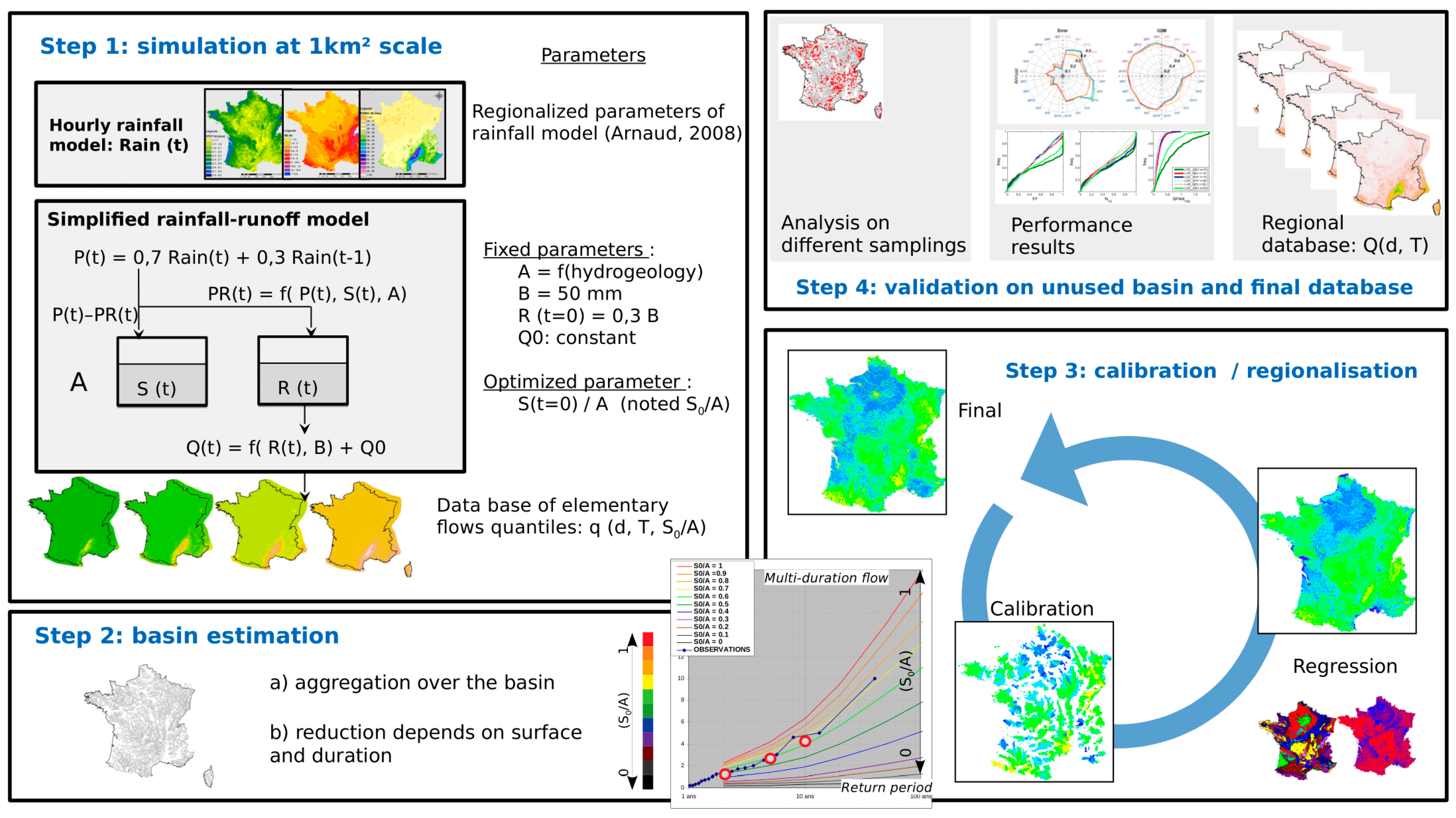
2.1. The SHYREG Method
The SHYREG method is the regionalized version of the simulation-based SHYPRE method (simulation of HYdrograph for flood PREdiction), which combines an hourly rainfall stochastic model with a conceptual rainfall–runoff model to generate a set of flood hydrographs from which empirical flood quantiles are estimated, for different durations and return periods [
30,
53]. The purpose of the SHYREG method is to regionally estimate flood frequencies. Its implementation requires the regionalization of both the hourly rainfall generator and the rainfall–runoff model. The processing chain associated with the implementation is presented in
Figure 1.
The hourly rainfall model has already been regionalized using daily rainfall data, which is more broadly available than hourly data in France. This process is detailed in a methods guidebook [
54]. It is based on mapping three daily rainfall variables (related to characteristics of intensity, duration, and frequency of rainfall) to calibrate the hourly rainfall model. These three variables, estimated for two seasons (from June to November and from December to May), were determined and mapped using 2812 rain gauge stations across the entire French territory, taking into account local environmental and topographical characteristics [
55]. Regionalized parameters were used to estimate the hourly rainfall model parameters and to simulate at site hourly rainfall events. In this study, these parameters are considered as an input to the method.
For the regionalization of rainfall–runoff model, we chose to simplify the hydrological model and to convert hourly rainfall into flood flow at a pixel resolution of 1 km2, because the rainfall generator is onsite and is not a rainfall field generator.
To generate rainfall events, the rainfall model parameters were set to the regionalized values of the pixel. Hourly rainfall events were then generated at the pixel scale and transformed into flood events with a simplified rainfall–runoff model [
56,
57,
58] derived from Yang’s model [
59] to provide elementary flow quantiles. This simplified hydrological model consists of a production reservoir, a routing reservoir, and a unit hydrograph, and is used in event mode to convert the hourly rainfall scenarios into flood scenarios at the pixel scale, as described in papers [
60,
61]. Most hydrological model parameters are set to a single value or imposed to a regional value [
62]. Only the initial filling rate value of the production reservoir varies from pixel to pixel. This parameter is the most sensitive one in the model and can be considered as a non-linear runoff coefficient applied to the simulated rainfall. It represents a sort of average initial moisture state of the pixel at the beginning of each rainfall event and is noted S
0/A. This initial moisture state will obviously evolve during the event and may tend towards saturation for the strongest events.
Initially, a same value of S0/A parameter was attributed to all pixels in the studied area, except those covered by urbanized area, where values were imposed. This first step involved carrying out simulations at the pixel scale, for different values of hydrological parameter S0/A. Flood events were simulated based on each of those values, at each pixel. The flood quantiles were then empirically extracted from these simulated events for each square kilometer to create a database of “elementary flow quantiles.” In order to estimate catchment flow quantiles, elementary flow quantiles were aggregated (summed up) from all the pixels in the catchments (step 2). Then, an areal reduction factor is used to simultaneously take into account both the rainfall areal reduction and the flood routing. This factor only depends on the catchment area and the examined duration.
The calibration step (step 3) consists of determining which value of S
0/A should be used to correctly estimate the current flood frequencies closest to the observed ones at gauged stations. The optimized parameter is the value that can minimize a weighted relative error criteria between flow quantiles, noted
, described by Equation (1).
In (Equation (1)),
corresponds to flow quantile indice and varies from 1 to 6, respectively, for the peak flows of 2, 5 and 10-year return periods and mean daily flows of 2, 5 and 10-year return periods.
are the flow quantiles obtained from observations resulting from applying a GEV probability distribution for which the value of the shape parameter is limited between 0 and 0,4 (to reduce sampling effect). GEV probability distribution is largely used to fit flood frequency [
63]. The choice of probability distribution used to estimate “observed quantiles” is relatively insignificant as long as we are dealing with low return periods (<10 years).
are the same flow quantiles simulated by the SHYREG method. Weights (3, 2, 1, 3, 2, 1) are attributed, respectively, to different quantile relative errors, to emphasize more frequent quantiles. Thus, calibration does not force the frequency extrapolation produced by the method.
For each gauged catchment, the SHYREG method can now be calibrated by optimizing the S
0/A parameter, on which the regionalization process will rely to apply the method over the entire drainage network (including ungauged environments). To regionalize the S
0/A parameter, instead of uniformly distributing one value to each catchment, we can search for a relationship between the parameter and morphological characteristics. This regionalization step is, in fact, performed at the same time as the calibration step, since optimization concerns coefficients of linear regressions. This approach is more widely described in [
64,
65] and presented in the following paragraph.
Lastly, the method is implemented through a spatial validation (step 4), applying the result of regional calibration on gauged catchments which are not used in the regional calibration phase.
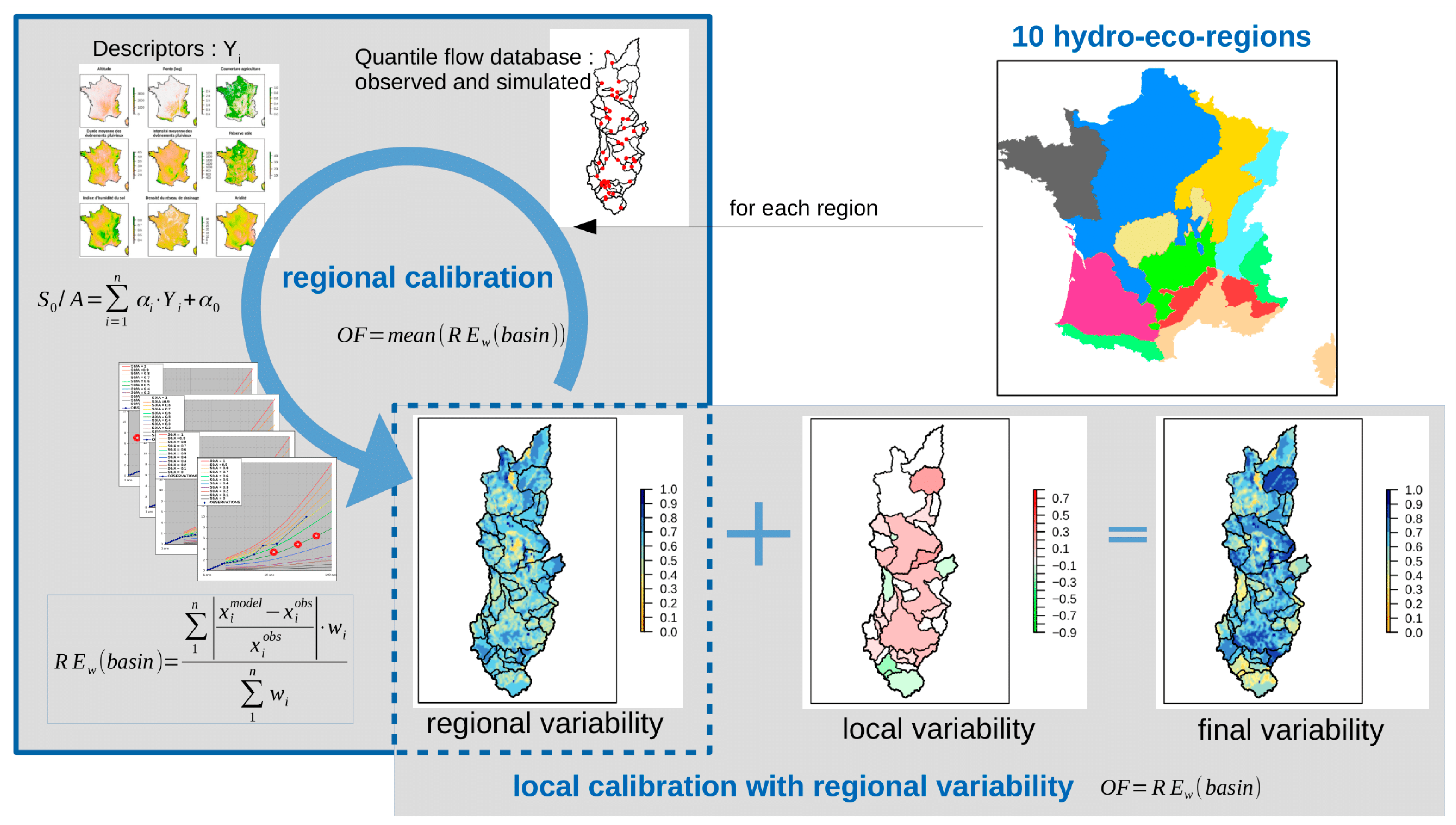
2.2. The Regional Calibration Procedure
The regional calibration procedure of the SHYREG method consists of optimizing the value of the hydrological parameter S
0/A while proposing a spatial variability to this parameter and is conducted through relations established between the parameter and descriptive characteristics of the catchment environment. The descriptive variables used are climatic, land use, geological and morphometric. The chosen calibration procedure is performed in two steps, at two different spatial scales, described below (
Figure 2).
The first step is a calibration carried out on a large scale. The aim is to optimize coefficients in a multiple linear regression to determine the values of the S
0/A parameter which leads to the best possible restitution of flood quantiles on calibration catchments. The calibration criterion is a weighted relative error (
) criterion between so-called observed flow quantiles and so-called simulated flow quantiles presented in
Figure 2 and in Equation (1). Optimization at this regional scale consists of minimizing the average of
on the sample of catchments in the same region. This first step, called “regional calibration” proposes a spatial variability to the parameter, guided by catchment characteristics. The value of the parameter thus obtained is called the “regional value”. However, this value is not optimal for fitting with “observed” flow quantiles in each catchment.
A second step consisting of an optimization is made for each catchment, which corrects “regional values” to fit flow quantiles (<10 years) which are observed locally in the catchment. This correction is applied in a spatially uniform manner on all the entities called “complementary basins”. The notion of “complementary” basins is associated with nested basins, which contain areas common to several basins. A “complementary basin” is assigned to each outlet of the nested basins for areas which are not controlled by the catchments upstream of this outlet. The local calibration of the correction value is applied homogeneously on complementary basins (“local variability”), while keeping the spatial variability imposed by the regional value of the parameter (“regional variability”). The regional calibration phase applied to a set of calibration catchments produces a mapping of the S0/A parameter. It can be used to simulate and determine the quantiles of flows on validation catchments, to judge the relevance of the regional flood frequency estimation method.
2.3. Taking into Account of Seasonnality during Calibration Procedure
So far, SHYREG method calibration has been carried out to optimize the weighted relative error criterion () calculated based on six annual flow quantiles, which are the annual quantiles of peak flow (QP) and daily flow (QJ) of 2, 5 and 10-year return periods. Thus, the calibration of S0/A parameter is performed with all simulated rainfall events. This parameter has a spatial variability but remains constant in time. On the other hand, the rainfall model is capable to distinguish two types of rainfall associated with two seasons. Regional parameterization of the rainfall generator distinguishes between two sets of parameters: parameters determined for the so-called winter season, extending from December to May, and for the summer season, extending from June to November.
In France, winter is associated with rainfall events that are on average longer, more frequent, but less intense than summer ones. It is also possible that rainy events in the summer occur more frequently in periods when soil is drier than in the winter. Systematically associating events with the same initialization of the hydrological model in different seasons may create a potential bias.
In this article, we endeavored to conduct and analyze a calibration of the hydrological parameter S0/A by distinguishing the two seasons defined for the rainfall model. For each catchment, we did not determine a unique value for the hydrological parameter, but two distinct values for the winter and summer seasons. The objective was both to evaluate how this new calibration procedure performs locally and regionally, as well as the impact that this may have on extreme flood values estimation.
The developed method aims to assess the impact of taking into account seasonality on regional estimates. For this reason, the method was applied to the whole French territory, with data to be presented in the following session. Sampling was set up so as to calibrate the method locally and validate it regionally.
In the calibration process, four tests were performed in terms of how seasonality is taken into account in the method (
Table 1). Initially, seasonality was only considered through seasonally parameterizing (“winter” and “summer”) the rainfall model. In this first case (“Calibration_1”), the optimized and regionalized hydrological parameter was the same for both seasons and was based only on annual observed quantile restitution. In the second test (“Calibration_2”), we determined a seasonal parameterization for the hydrological model, but only based on annual observed quantile restitution. This is equivalent to increasing the number of freedom degrees in the model calibration without increasing the calibration constraint. In the third test (“Calibration_3”), hydrological parameter calibration was performed seasonally by optimizing parameter for each season separately. The hydrological parameter of a season was optimized based on the “observed” quantile restitution for the same season. In this case, annual simulated quantiles were determined by combining the quantiles of both seasons, which were not used in the calibration procedure. Finally, the last test (“Calibration_4”) used all the “observed” quantiles (seasonal and annual) when optimizing both seasonal hydrological parameters.
To judge the relevance of the results, different criteria were evaluated based on formulating a criterion
detailed by Equation (2) [
66] and Relative Error
which is the same criterium as
with all weights equaling 1.
with
and
is the “observed” variable and
is the “modeled” variable.
Criteria can be calculated for each catchment when the variable comprises values determined for a same basin. These criteria are noted and . In this case, we will present the frequency distribution of the criteria. It can also be calculated for a given variable with values of all studied catchments. This produces one value per variable, noted or . In our case, is quantiles of peak flow (QP) and daily flow (QJ) of 2, 5 and 10-year return periods.
2.4. Data
Our study area is the entire French territory, for which the SHYREG method, described in the previous session, was developed. The method has already been calibrated locally on 1535 gauged catchments to determine its parameters. These parameters were then regionalized in order for the method to be used in ungauged sites [
65]. In this study, 1929 gauged catchments were used throughout France. These catchments have a minimum observation period of 10 years, with an average observation period of 38 years. Their surface areas are between 1 and 5000 km
2, with an average value of 663 km
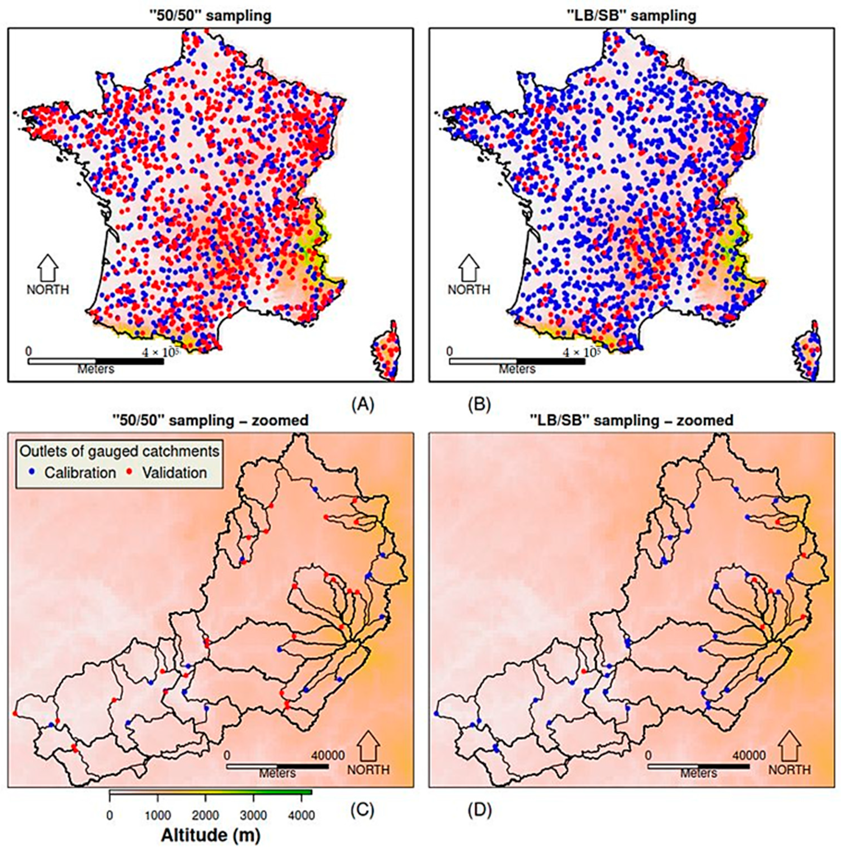
2. To evaluate the performance of the method in an ungauged context, a sample of gauged catchments were reserved as validation catchments and not used in the calibration and regionalization step. The flow quantiles simulated in these catchments were used to compare with observations for validation. Two samplings were conducted to separate calibration catchments (donors for regionalization) and validation catchments (receivers for regionalization) and are presented in
Figure 3.
These two samplings are noted as “50/50” sampling and “LB/SB” sampling. The “50/50” sampling is made up of 50% of basins chosen at random for calibration while the remaining 50% are kept for validation. The characteristics of catchments for calibration and for validation are very similar in terms of surface, land cover or hydro-climatic context. This sampling evaluated the method’s ability to provide information over the entire territory, both inside and outside the gauged basins. The “LB/SB” sampling is made up of catchments with an area greater than 70 km2 (1587 largest catchments) for calibration and the catchments with an area smaller than 70 km2 (342 smallest catchments) are kept for validation. This sampling focused on the method’s ability to provide information on the smallest watersheds upstream of gauged catchments. It tested the ability of the method to provide information at small scales with larger information, in order to estimate flood quantiles on ungauged basins.
The main difference between these two samplings is the characteristic transferability towards ungauged sites. The calibration catchments of “50/50” sampling provide characteristic variability at all scales. Therefore, the regionalization procedure can be described as transferring knowing information to ungauged sites at the same spatial scale. Yet, during the regionalization phase using “LB/SB” sampling, information from small catchments were not used. Thus, regionalizing parameters could be more difficult.
Rain model parameters are also input data for this study. Their values were determined in previous studies across the French territory, as specified in the paragraph describing the method.
Available flow data on gauged basins is provided by the HYDRO French database (
http://www.hydro.eaufrance.fr/ accessed on 1 April 2021). Maximum annual flow values were extracted for the two seasons studied and for the annual period. The “observed” quantiles were calculated over both seasons and the annual period by applying a GEV law with a regionally constrained shape parameter. This results in quantiles of peak flows and daily flows of 2, 5 and 10-year return periods and in three periods (“annual”, “winter” and “summer”).
Several databases allowed us to extract descriptive catchments characteristics. Climatic data from extracted SAFRAN data [
67,
68] helped determine climatic characteristics of rainfall, aridity, and water balance. Altimetric data allowed us to determine morphometric characteristics of the catchments (slope, orientation, altitude, etc.). Land use data allowed us to determine vegetation coverage types for the catchments (forest, grassland, agriculture land, etc.). Geological data allow us to determine soil types or potential water storage capabilities for the catchments (rock, sand, wet land, etc.).
All this data allow us to apply the method according to different configurations, related to the tests performed and presented in the next session.
3. Result
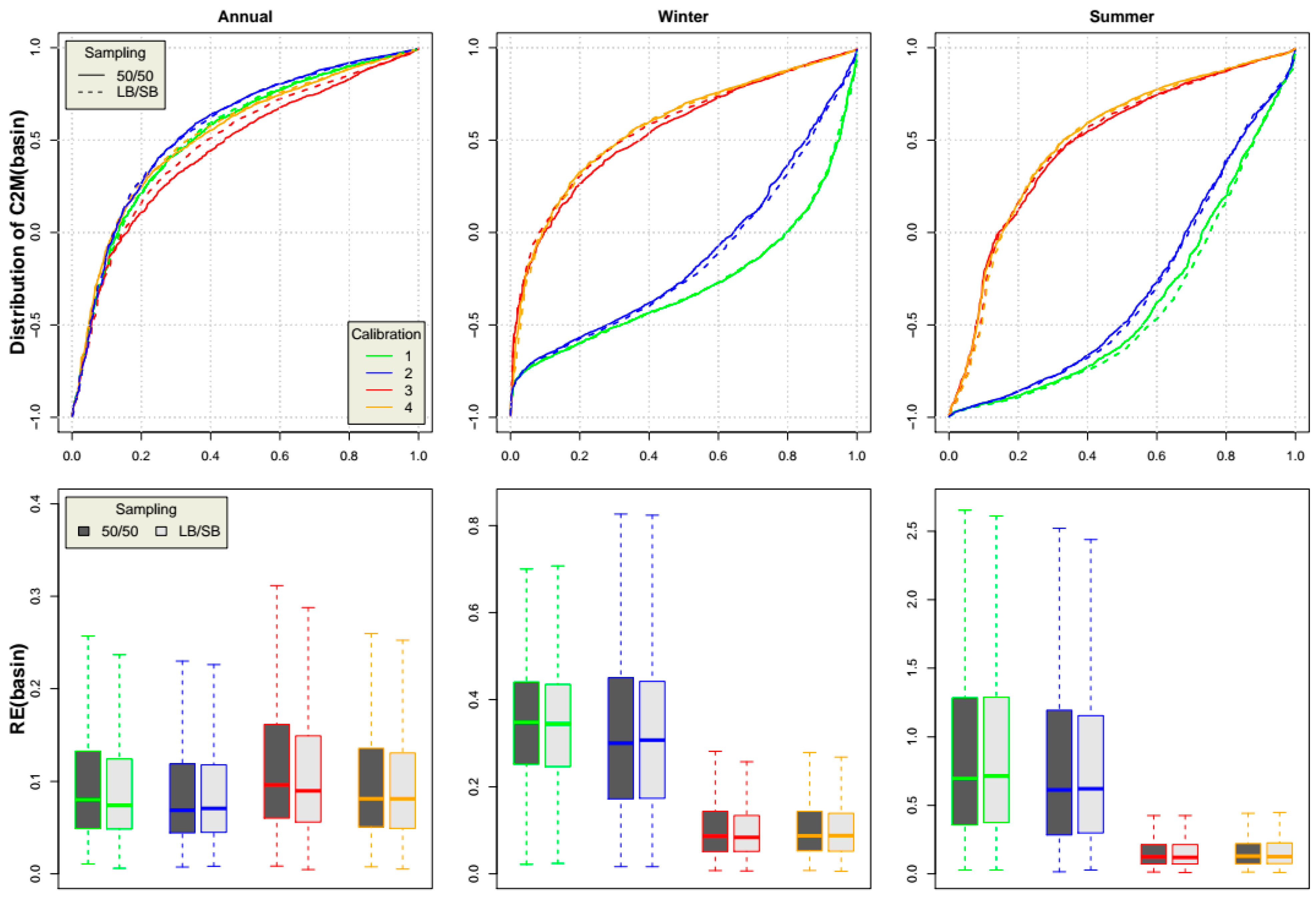
3.1. Calibration Results
Calibration results are presented in
Figure 4. The figure shows the distribution of criteria
(full distribution) and
(boxplot) for different calibration tests (“Calibration_1” to “Calibration_4”), and for both calibration samples (“50/50” and “LB/SB”). Results are organized in columns according to the period in which criteria are calculated. Below are criteria calculated, respectively, on flood quantiles for the “annual”, “winter”, and “summer” periods, going left to right in the graphs.
We observe that all four calibration configurations led to similar performances for the restitution of “annual” quantiles. “Calibration_2” performed slightly better than “Calibration_1”, due to the presence of an additional parameter in the calibration, although they were calibrated based on the same information (annual quantiles). “Calibration_3” is the least efficient because it is the only one that does not take into account annual flow quantiles. However, this calibration, which is performed only on seasonal flow quantiles, still leads to good performances when restituting annual flow quantiles by recombining flow quantiles of both seasons. Finally, the performance of “Calibration_4” is very close to that of the first two calibration tests.
We then focused on restituting seasonal flood quantiles (“winter” as well as “summer”). We observed that the configurations (“Calibration_1” and “Calibration_2”) which calibrate the method only based on annual quantiles cannot reproduce correct seasonal quantiles. This difficulty is more pronounced for “Calibration_1”, which has only one parameter. However, even for “Calibration_2”, which can use two parameter values, the proper value for the pair of winter and summer parameters S0/A cannot be found to obtain reasonably correct seasonal quantiles (unused for calibration).
Finally, “Calibration_3” and “Calibration_4”, which optimize their parameters based on seasonal quantiles, naturally lead to a good restitution of the latter. Interestingly, calibrating on the seasonal quantiles helps correctly restore the annual quantiles, whereas the opposite is not possible. This new parameterization distinguishing different parameters for the two seasons is largely preferable, even if it slightly restricts the restoration of annual quantiles. It does, however, respect seasonal parameter variability.
Since the method aims to provide information on hydrological hazards in ungauged sites, its performance must be judged based on validation catchments. Before looking at validation catchment results, we first examined how representative the optimized parameters were, through their capacity to be explained by catchment descriptors. The graphs in
Figure 5 (Distribution of R-squared between S
0/A parameter and basin descriptors, for the two seasons and the two samplings) present determination coefficient (r
2) values for regional regressions obtained in the regional calibration phase, as explained in
Figure 2.
Regional calibration was performed in ten zones that divide France into hydro-eco-regions [
69]. The distribution of determination coefficients (r
2) is shown for the four calibration tests, both seasons, and for the two calibration catchment samples.
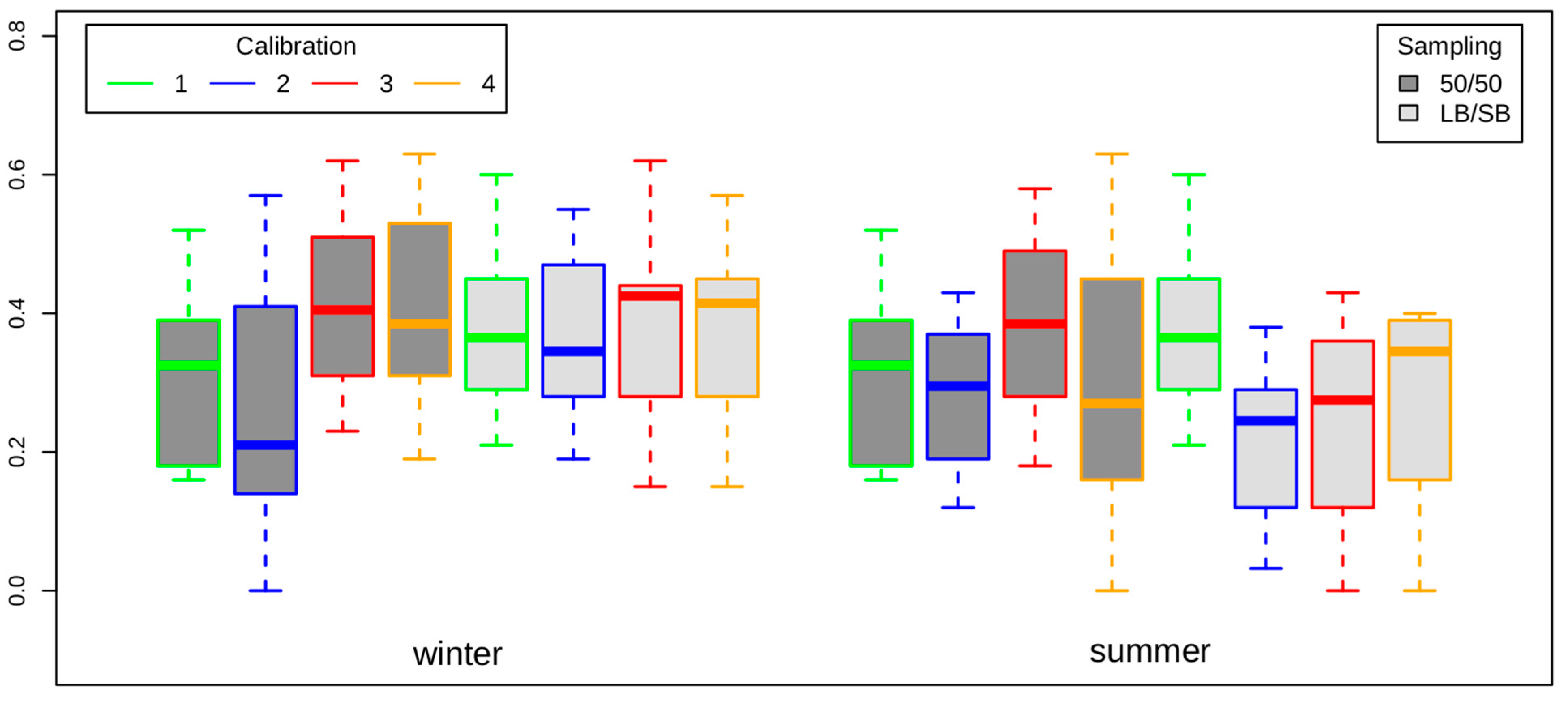
For the “50/50” sampling, we observe that seasonal parameters determined by “Calibrations_3” and “Calibrations_4” are better correlated to catchment descriptors than those determined by “Calibrations_1” and “Calibrations_2”. This result is less clear for the “SB/LB” sampling, which is intended to examine the transferability of these parameters inside the catchments, whereas the “50/50” sampling is more interested in the transferability of the parameters outside the catchments. It can also be noted that for both samplings, “Calibrations_2” has the lowest correlations.
It seems that at a regional scale, the representativeness of the seasonal parameters is more relevant than the annual parameter. We also notice that if these seasonal parameters are determined only through the annual observation, their representativeness is limited. This is linked to the fact that in the case of “Calibrations_2”, the seasonal parameters do not really make sense. They are suitable for returning annual quantiles but not seasonal ones and are more weakly correlated with catchment characteristics.
It can therefore be imagined that seasonal parameterization, determined using seasonal information, would be more relevant to estimate flood quantiles in an ungauged context. To verify this, we look at the restitution of flood quantiles using a regionalized method in the validation catchments.
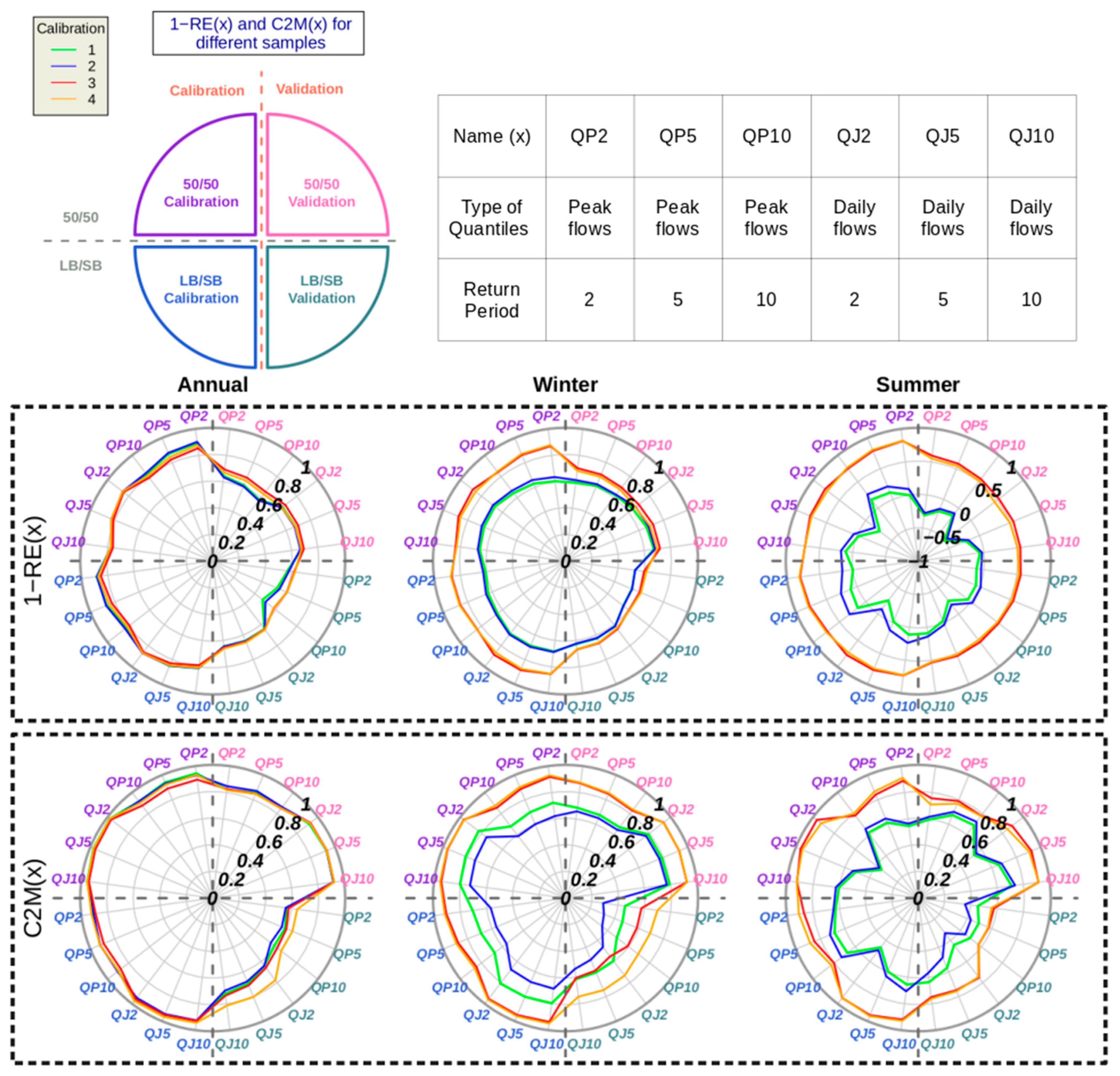
3.2. Validation Performance
The graph in
Figure 6 shows validation catchment results for the four calibration tests and the two samplings studied. Results demonstrate so-called spatial criteria (
and
) for the different flood quantiles: QP
T corresponds to quantiles of peak flows of return period T and QJ
T corresponds to quantiles of daily flows of return period T. To help in understanding the result, considering that
(where X is a type of flood quantile) represents the distance between simulated quantiles and observed ones, we used
to demonstrate the similarity. Therefore, if
is close to 1, then simulated quantiles for quantile X are very similar to observed ones, such as for the
criterium.
The same trends are found here as for the calibration catchments. Calibration tests (“Calibration_1” and “Calibration_2”) that do not take into account seasonal quantiles during the calibration phase cannot recover seasonal quantiles in spatial validation. We also note that when restituting annual quantiles, all the methods did well, even “Calibrations_3”, which was not calibrated based on annual information but only on seasonal information.
However, if we look at all the quantiles (annual and seasonal), “Calibration_4” leads to the best results for validation catchments. This is consistent with the fact that the calculated parameters regionalize better and consequently produce better results in spatial validation. Noting that the “LB/SB” sampling leads to weaker validation criteria than those obtained for “50/50” sampling, this demonstrates how performing a “spatial down-scaling” compared to a spatial interpolation is more difficult. Given this difficulty, “Calibration_4“ shows itself even more discrete and relevant. This result is probably due to both the relevance of the implemented parameterization and the robustness of its calibration, performed by more variables.
4. Discussion
4.1. Seasonal Flood Frequency Estimation
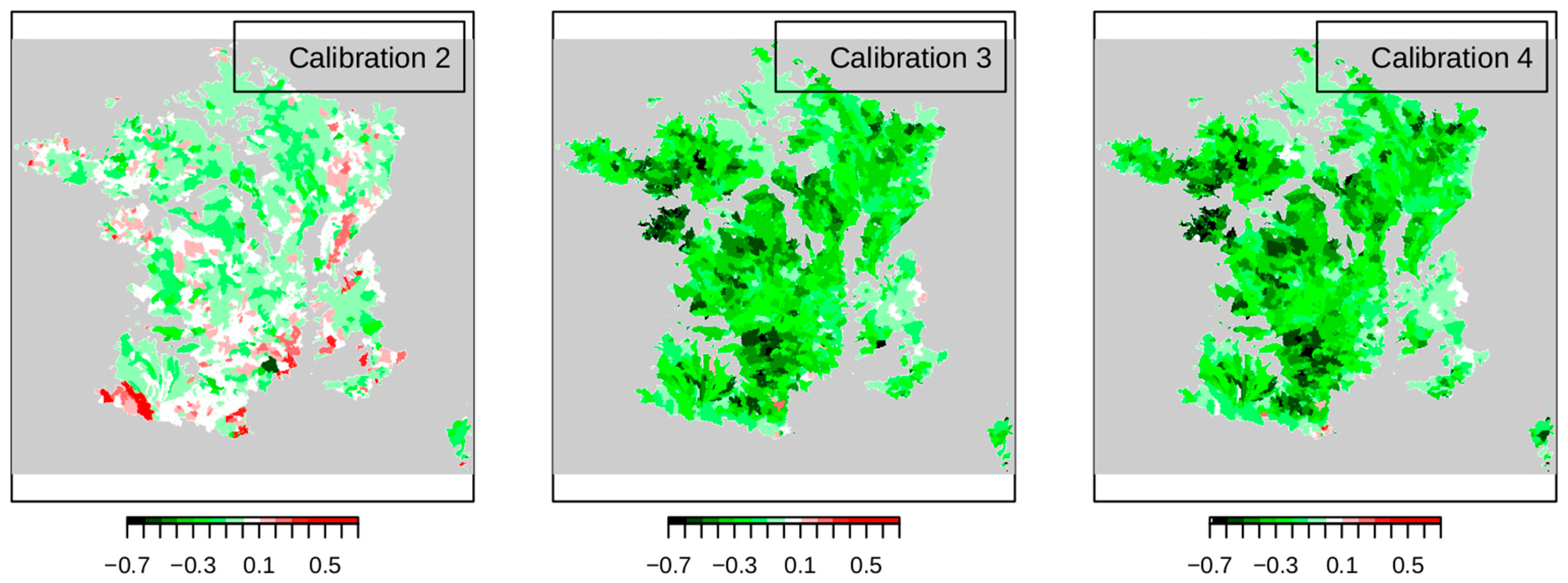
Considering a seasonal parameterization of the hydrological model can recover seasonal quantiles. Using different values for hydrological parameters to model summer and winter flows is therefore interesting. Here, we focus on values taken for this parameter according to the seasons. The maps presented in
Figure 7 show the difference between the values of winter and summer parameters S
0/A.
We observe that when the calibration is performed only on annual flood quantiles (“Calibration_2“), the parameter difference between two seasons is randomly either positive or negative, without any logical spatial distribution. On the other hand, for “Calibration_3“ and “Calibration_4“, which consider seasonal information during calibration, parameter values in winter are systematically higher than summer values. This result seems logical, as the average state of soil moisture at the time of rainfall is probably drier in summer. However, there are areas (especially in the Alps) where value differences between two seasons are very small. It is likely that, for these areas, which are more humid in summer, initial humidity conditions in the catchments are less variable throughout the year.
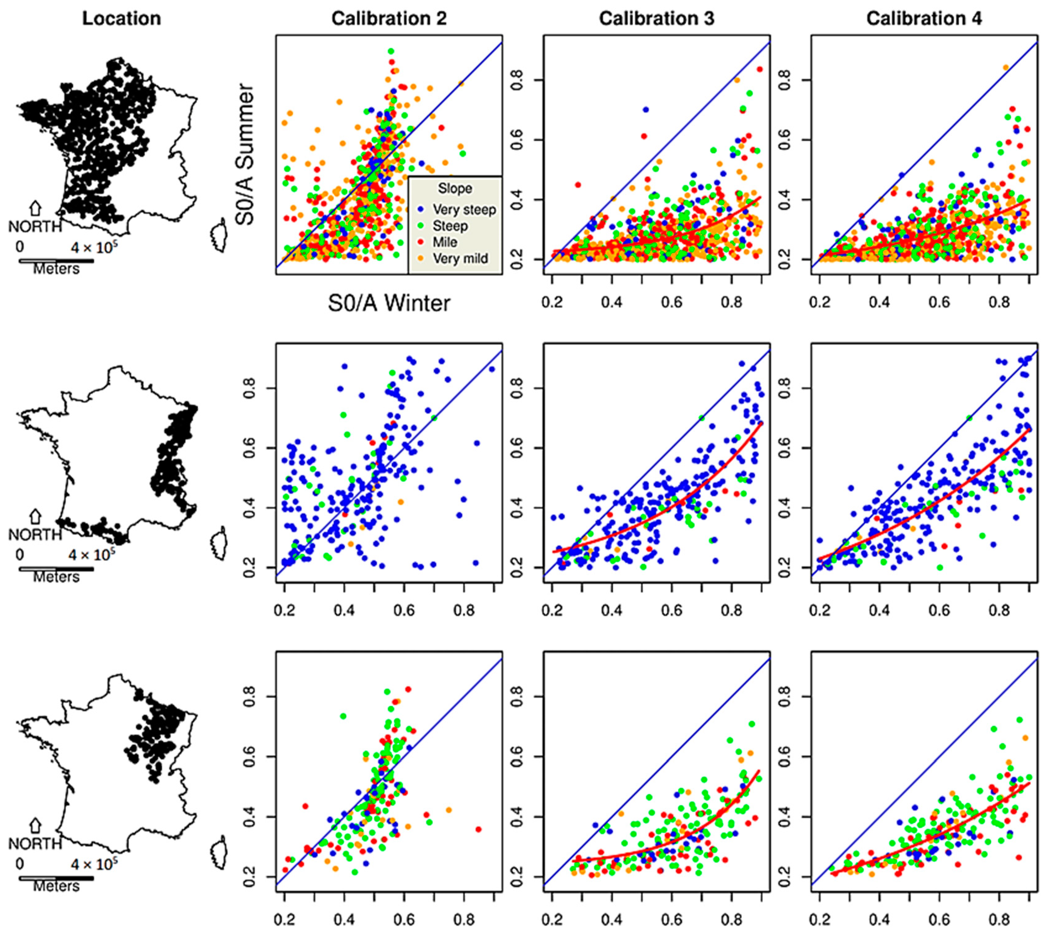
The
Figure 8 graphs help refine the analysis. For three different catchment groups, parameter values for the summer are presented as a function of winter ones. Regardless of the studied group of catchments, there is no relationship between values taken for both seasons with “Calibration_2”. On the other hand, relationships between the parameters are observed with “Calibration_3” and “Calibration_4”, varying according to the studied catchment groups.
We noted that the seasonal trend between parameter values for “Calibration_2” is invisible compared to the others. The seasonal parameter for “Calibration_2” was calibrated based on annual flow quantiles, without any information on seasonal flow. During the calibration, a pair of winter–summer parameters was selected for all pixels of each catchment to minimize the related error of annual flow quantiles. Hence, the calibrated parameters were numerically the “optimal” ones in restituting annual flow quantiles, but not for seasonal quantiles. Annual flow information alone cannot provide seasonal flow information, despite seasonal information of rainfall. Additionally, seasonal parameters do not correspond to consistent values. This is not the case for “Calibration_3” and “Calibration_4”, whose parameter was calibrated based on either seasonal flow quantiles or all possible flow quantiles (annual + seasonal). With the help of those seasonal flow data, the parameter values are closer to the soil condition for each season.
We then tried to verify if the seasonal trend found for “Calibration_3” and “Calibration_4” was reasonable. In the first group, associated with oceanic and temperate climates in France, and with areas of high permeability, we observe a very strong seasonal trend between parameter values obtained for two seasons. This is typical for high-permeability catchments, associated with climates that tend to be humid in winter and dry in summer. The second group corresponds to catchments in mountainous areas. Here, parameter values for two seasons are very similar. The steepest catchments (blue dots) have the highest parameter values in the summer. These catchments are high-altitude catchments with high runoff capacities whatever the period of the year. Finally, the last group corresponds to continental climate catchments, presenting an intermediate behavior with lower values in summer than in winter, but relatively correlated between them. A certain climate and hydrological coherence therefore appears in the differences of parameter values between seasons for different regions across the French territory.
4.2. Extreme Annual Flood Frequency Estimation
Parameterizations obtained using different calibration tests led to very different results for seasonal quantiles, with a strong bias when parameters were calibrated only with annual quantiles. On the other hand, annual flood quantiles restituted using different calibration tests were relatively close in calibration as in validation, as shown in
Figure 4 and
Figure 6. It could be said that if we are only interested in annual quantiles, the choice of calibration method would not be important because they all lead to close results. This might be true for frequent flood quantiles (return period < 10 years) on which the calibration focuses.
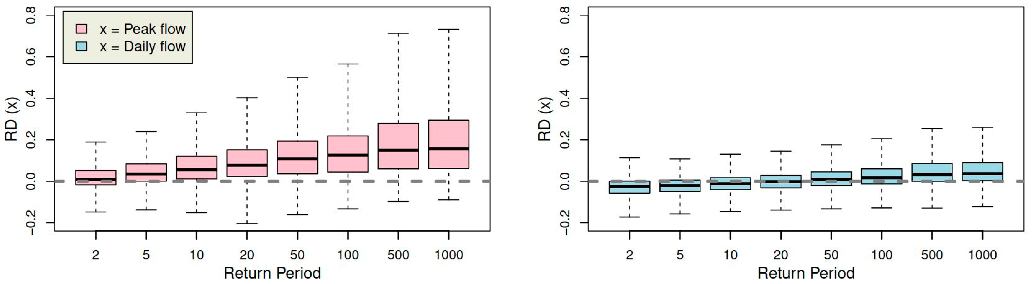
Here, we try to see the impact on determining the extreme values. Test results for calibration catchments are used to compare quantiles provided by these two parameterizations. For different return periods (between 2 and 1000 years), we calculated annual quantiles with parameters obtained using “Calibration_1” (
) and “Calibration_4” (
). From these quantiles, a relative difference was calculated considering the deviation sign (Equation (3)).
The distribution of these relative differences calculated for all calibration catchments is presented in
Figure 9 for different annual quantiles
.
We first observe that simulated annual quantile differences for peak flows are much larger than for mean ones, due to the calibration configuration. Moreover, the values and variability of this related difference both increase with return periods. The result is important for predicting very extreme floods. Both calibrations lead to a close annual quantile modeling for low return periods (<10 years), but the extrapolation towards higher return periods can diverge.
Considering a specific parameterization of the hydrological model can determine different catchment reactions to rainfall depending on the season. This seasonality provides a parameterization that is better adapted to seasonal observations and leads to an extrapolation toward extreme values which could be different (or worse) without considering this phenomenon.
This last point is important and perhaps essential when studying the impact of climate change on extreme floods. In the proposed seasonal approach, catchment behaviors are differentiated according to seasons, assuming that catchments are generally less productive in summer than in winter, due to different soil moisture conditions.
4.3. Overall Evaluation
We summarize in
Table 2 all the analysis and the discussion above to discuss the most adapted calibration configuration to the studied method and its advantages.
We re-emphasize here the purpose of testing these four calibration configurations. As mentioned in the context, former studies are well aware of the importance of rainfall seasonality to flood frequency estimation tools. That is why this article uses a regional simulation-based approach as a start point, which has already taken into account precipitation seasonality. The test “Calibration_1” was carried out to present its performance as its “initial state”, which estimated seasonal flow quantiles corresponding to the generated seasonal rainfall events. Three tests were then carried out to find the most suitable solution to introduce a new so-called hydrological model parameter seasonality. This parameter represents the average soil moisture condition at the beginning of each rainfall event.
The result of “Calibration_4” seems to be the best among the three calibration tests. It can correctly recover annual and seasonal flow quantiles in gauged catchments and has the best performance in estimating flood frequency in an ungauged context. Thus, we selected this calibration configuration as the final option and compared it to other studies.
It was found that if a regional flood estimation method considers rainfall seasonality but not hydrological parameter seasonality (such as “Calibration_1”), it can reasonably well estimate annual flood frequency in gauged catchments. Nevertheless, despite considering rainfall seasonality, estimating seasonal flood frequency is still very difficult. It shows the weak point of some event-simulation-based approaches. Since most regionalized methods rarely consider the hydrological seasonality, estimating seasonal flood frequency using these methods could create a strong bias. Furthermore, even in terms of estimating annual flood frequency, a seasonal approach can perform better in ungauged catchments. Additionally, as presented in
Figure 9, an extrapolation of flood frequency toward extreme values according to seasonal catchments behavior could lead to a more accurate result.
Compared to other regional flood frequency approaches based on frequency analysis, simulation-based methods are generally more complex. They usually do not consider catchment soil condition seasonality. Or if so, the studies of these approaches mainly focus on gauged catchments rather than an ungauged context. This article shows the possibility and the benefits to introduce seasonality when parameterizing the hydrological model of a simulation-based regional approach. It presented a practical seasonal parameterization method during the calibration and regionalization phase and analyzed performance in both gauged and ungauged catchments.
5. Conclusions
Regional flood estimation is an important issue in hydrology. Approaches based on process simulation are an effective way of addressing this because, on one hand, rainfall information is both largely considered in these approaches and easily determined regionally, and on the other hand, hydrological transformation can introduce elements to the functioning of catchments. It is for these points that the study has been conducted, using the parameterization of the hydrological model associated with the SHYREG method, a regionalized method of flood estimation based on process simulation.
This work is based on a very large sample of French catchments. Calibration and regionalization performances on catchments were evaluated according to different configurations. Our main objective was to determine the interest of taking into account seasonal variability when parameterizing the hydrological model.
To restitute seasonal variability of flood quantiles, only taking rainfall variability into account is insufficient, considering hydrological parameterization variability is as necessary as considering seasonal flow data. In fact, annual flow data alone cannot provide enough seasonal information to well calibrate seasonal parameters. Taking into account the seasonal information not only determines seasonal quantiles but also increases the interpretability of parameters when regionalizing them and consequently, better restituting flood quantiles at ungauged sites. Seasonal parameterization, which is essential for determining seasonal quantiles, does not, however, lead to large discrepancies when restituting frequent annual flood quantiles on which the calibration is based. By contrast, estimating extreme flood quantiles is impacted by this new parameterization.
It is worth noting that the seasonal variability of soil moisture conditions at the time of rainfall must be accounted for to determine catchment reactions at different times of the year. This can have consequences on calibrating approaches that will lead to equivalent performances in the calibration domain, but different ones in the extrapolation domain, whether spatially (regionalization) or in terms of frequency (extreme events). This work supports a better understanding of the seasonal variability of hydrological processes in the studied method, making the approach more suitable to be used in climate change contexts.


