
Holocene Hydroclimatic Changes in Northern Peloponnese (Greece) Inferred from the Multiproxy Record of Lake Lousoi

 ,
,
Abstract
1. Introduction
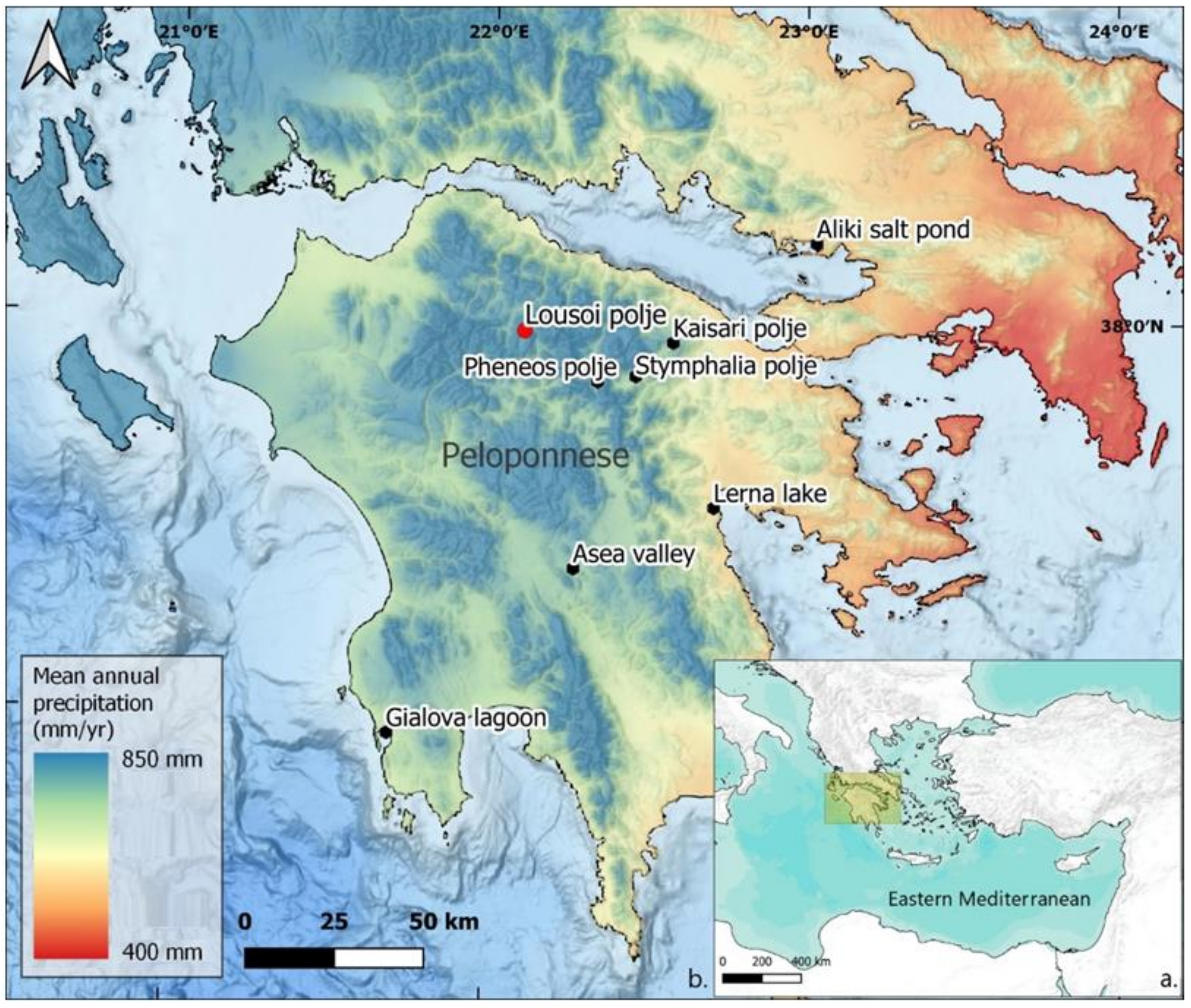
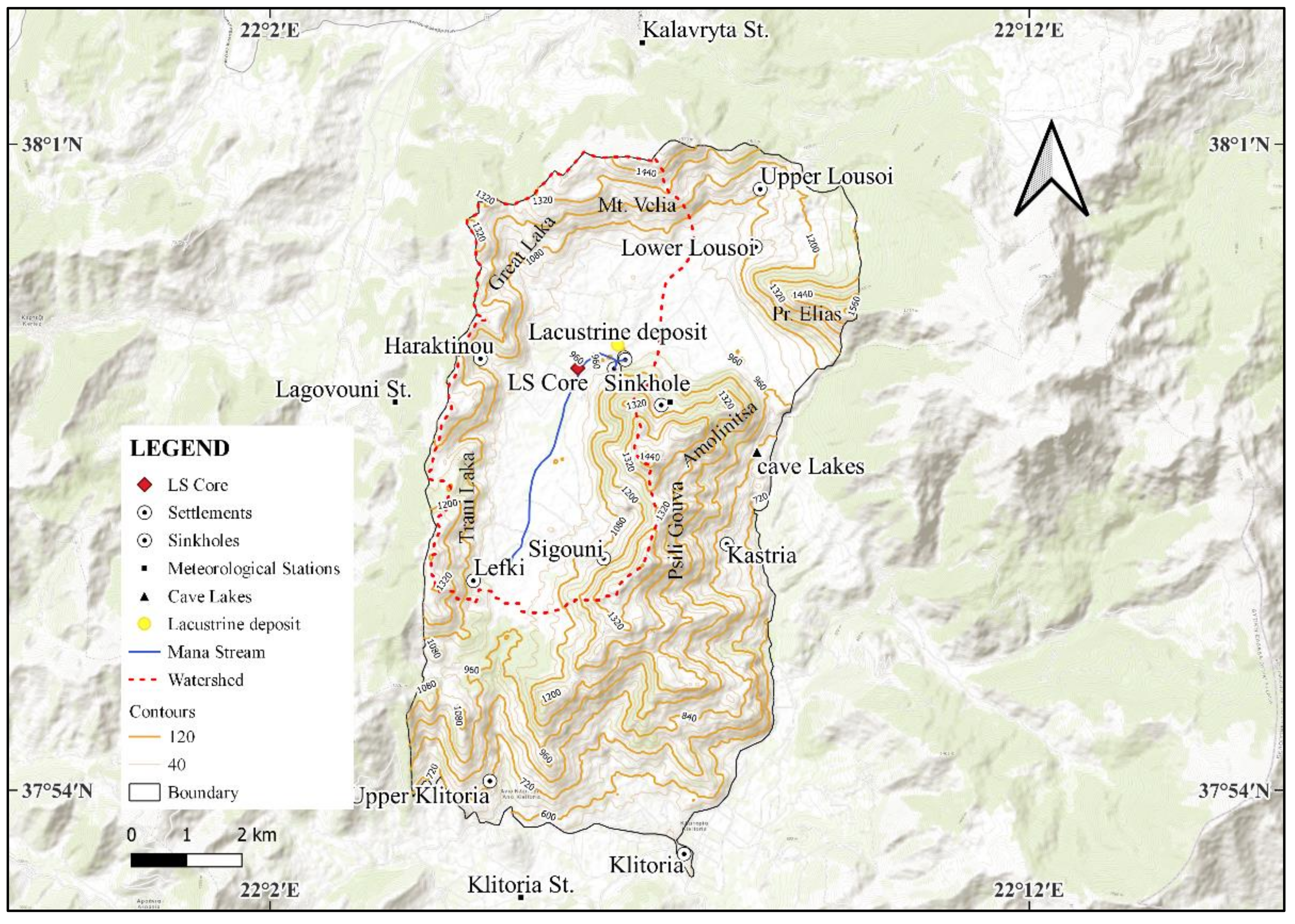
2. Study Area
2.1. Regional Setting
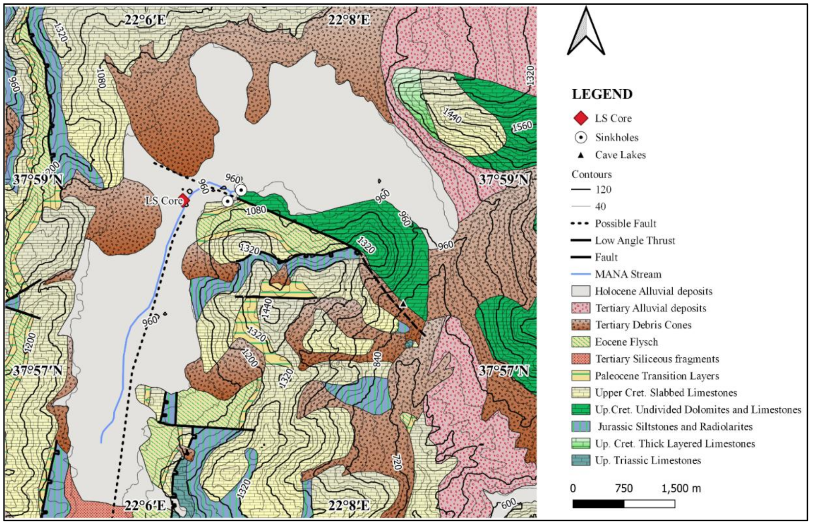
2.2. Geological Setting
3. Materials and Methods
3.1. Coring Fieldwork
3.2. Sedimentology
3.3. Elemental Variations and Radiocarbon Dating
4. Results
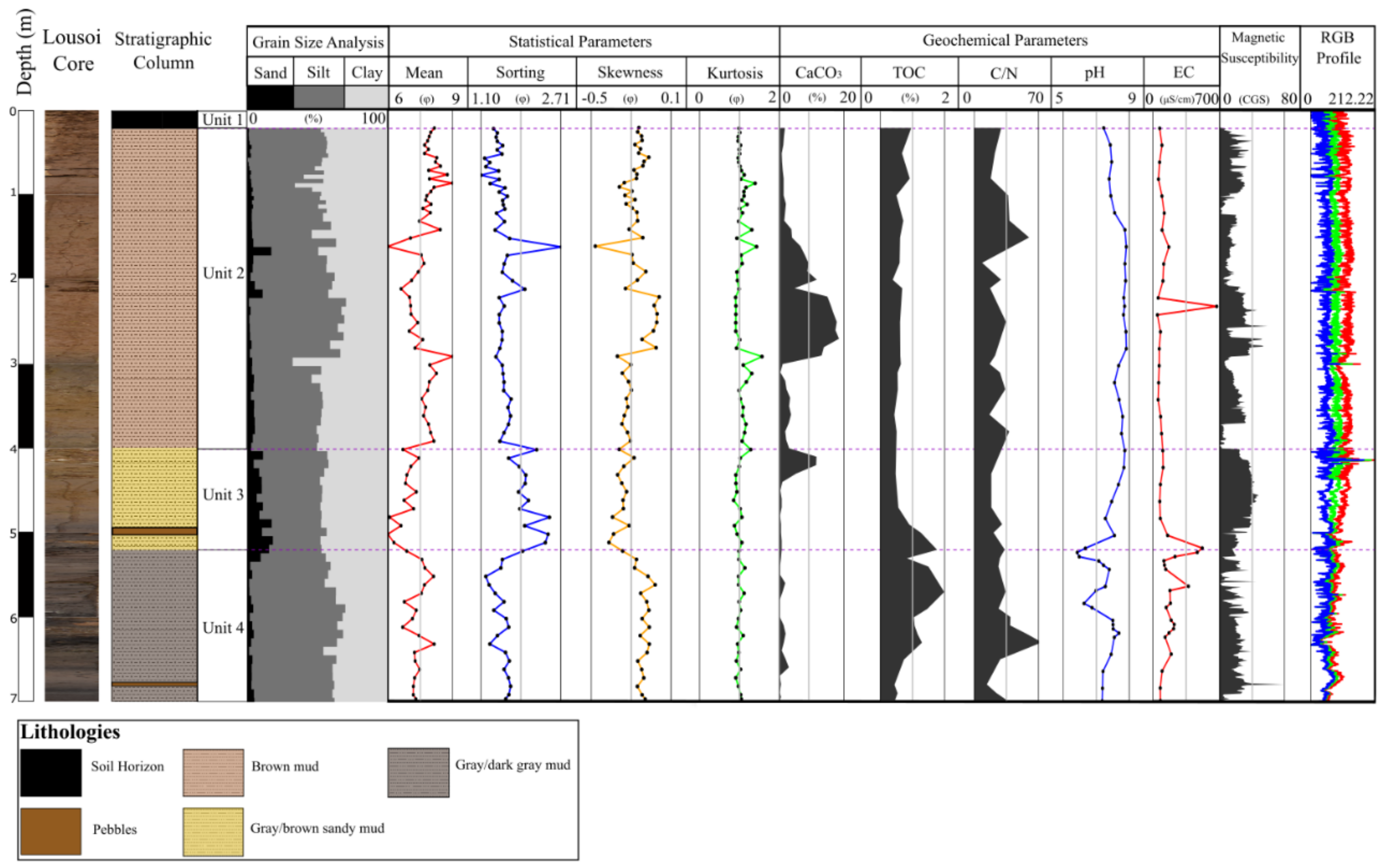
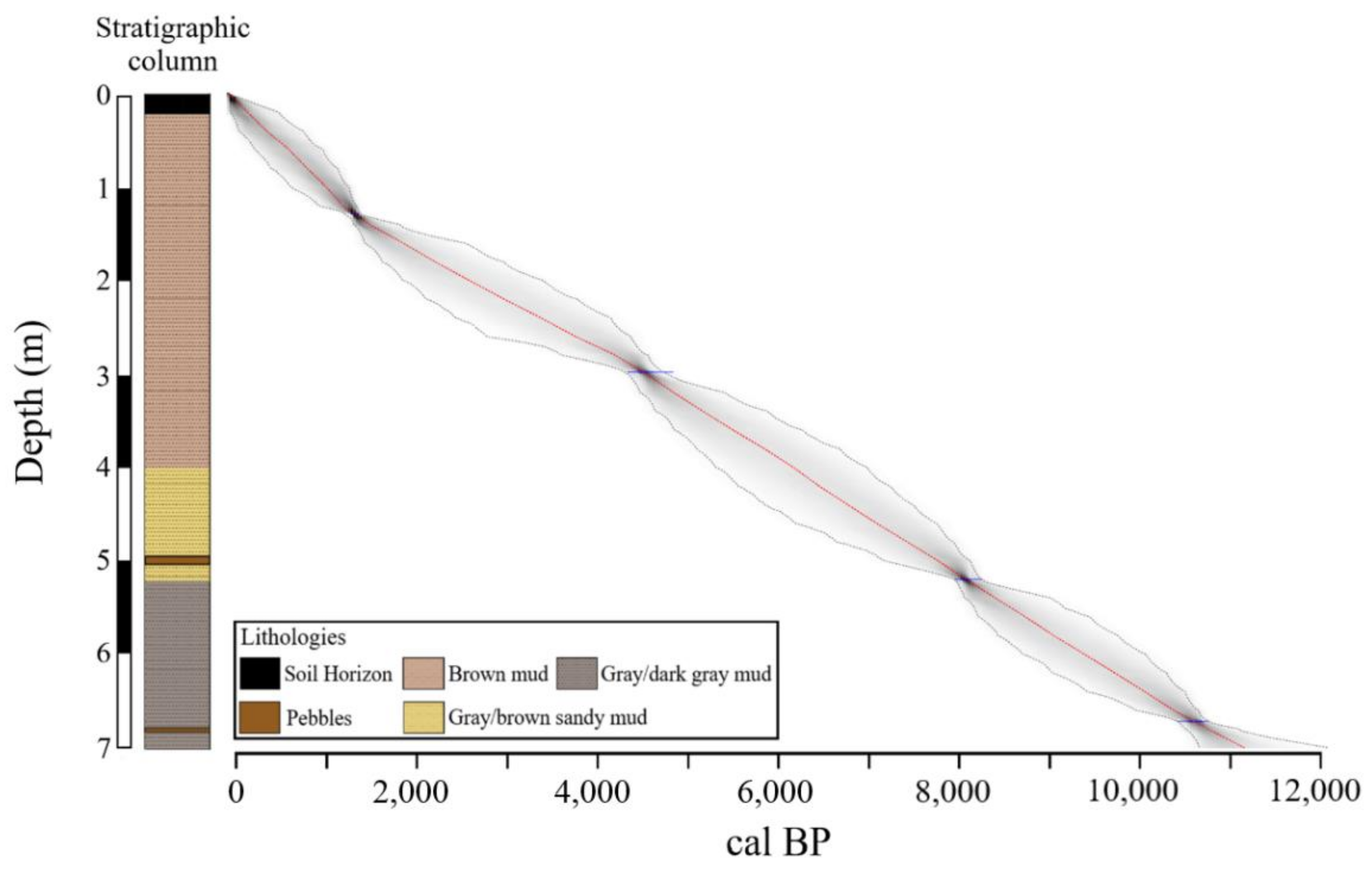
4.1. Core Description and Stratigraphy
4.2. Radiocarbon Dating and Age–Depth Model
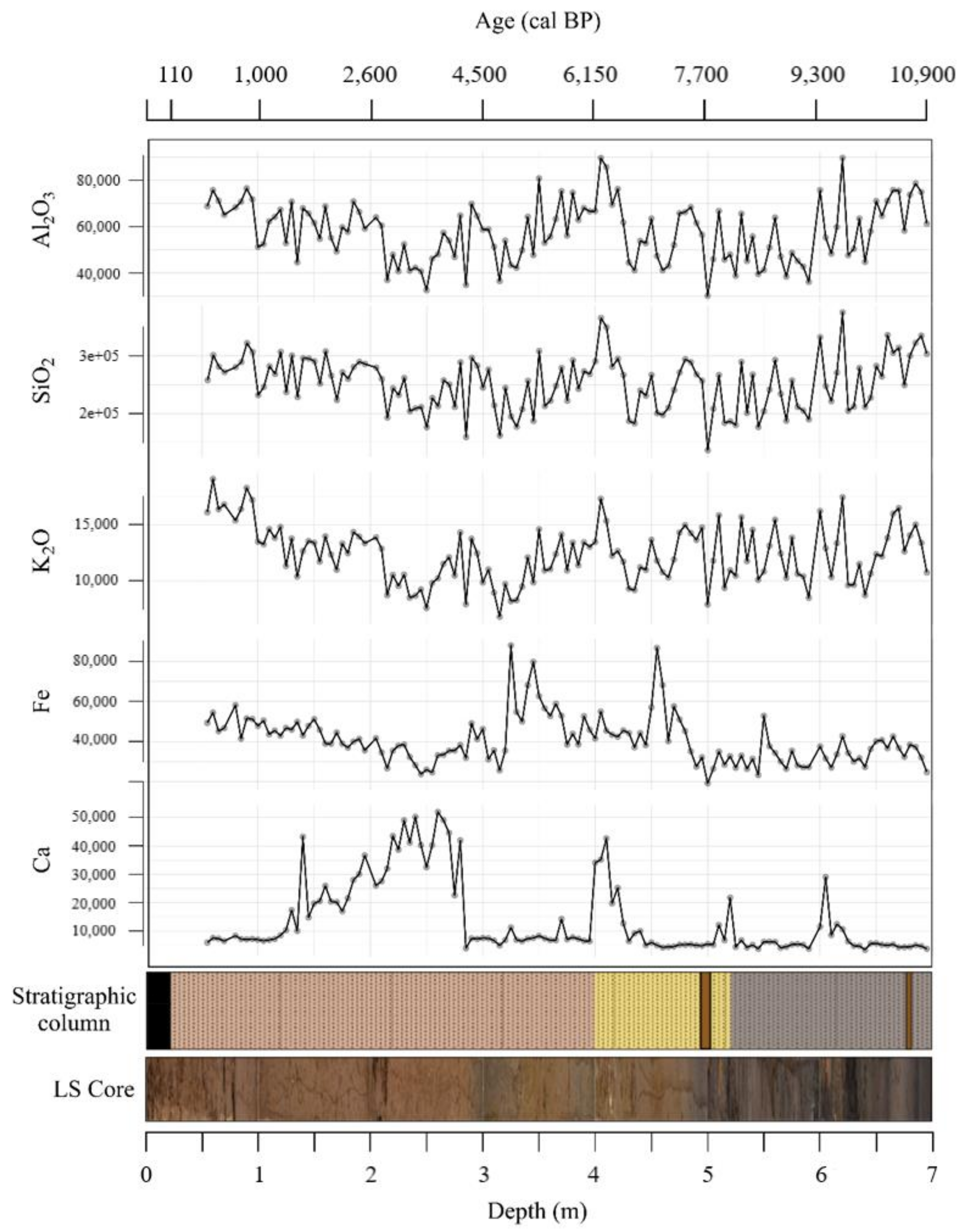
4.3. Distribution of Geochemical Proxies
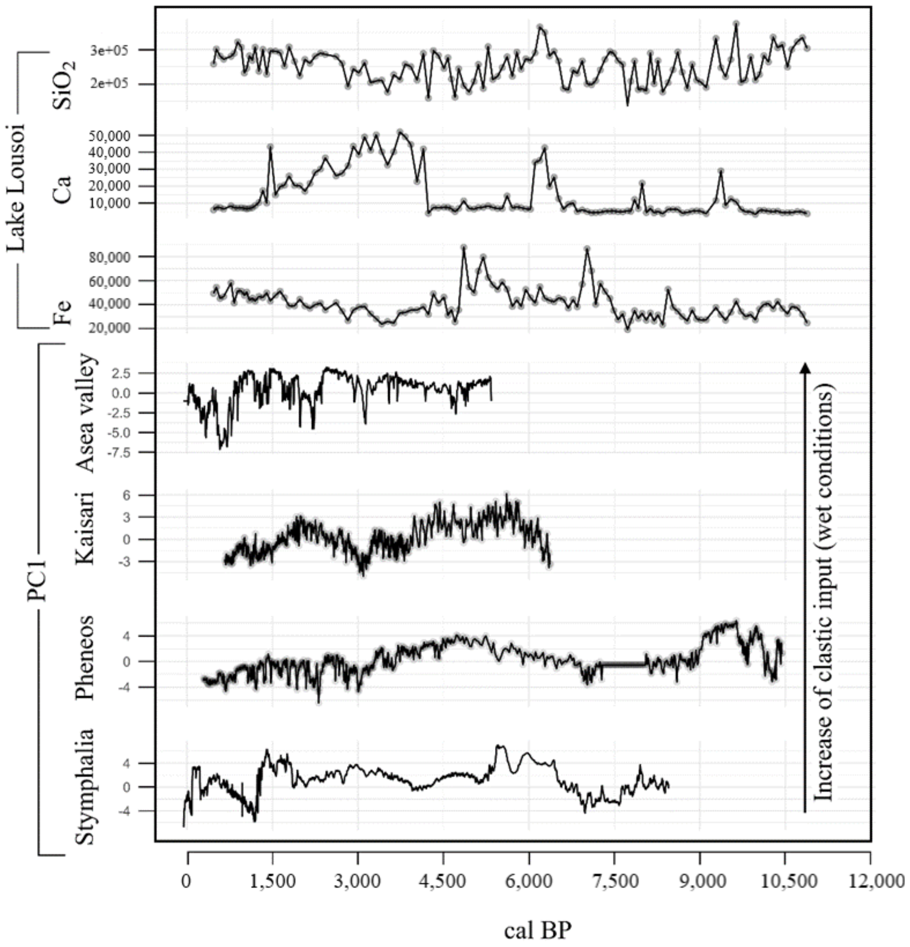
5. Discussion
5.1. Early Holocene (11,800–8200 cal BP)
5.2. Middle Holocene (8200–4200 cal BP)
5.3. Late Holocene (4200 cal BP–Present)
6. Conclusions
Author Contributions
Funding
Institutional Review Board Statement
Informed Consent Statement
Data Availability Statement
Acknowledgments
Conflicts of Interest
References
- Ulbrich, I.M.; Canagaratna, M.R.; Cubison, M.J.; Zhang, Q.; Ng, N.L.; Aiken, A.C.; Jimenez, J.L. Three-Dimensional Factorization of Size-Resolved Organic Aerosol Mass Spectra from Mexico City. Atmos. Meas. Tech. 2012, 5, 195–224. [Google Scholar] [CrossRef]
- Giorgi, F. Climate Change Hot-Spots. Geophys. Res. Lett. 2006, 33, L08707. [Google Scholar] [CrossRef]
- Emmanouilidis, A.; Katrantsiotis, C.; Norström, E.; Risberg, J.; Kylander, M.; Sheik, T.A.; Iliopoulos, G.; Avramidis, P. Middle to late Holocene palaeoenvironmental study of Gialova Lagoon, SW Peloponnese, Greece. Quat. Int. 2018, 476, 46–62. [Google Scholar] [CrossRef]
- Katrantsiotis, C.; Kylander, M.E.; Smittenberg, R.; Yamoah, K.K.A.; Hättestrand, M.; Avramidis, P.; Strandberg, N.A.; Norström, E. Eastern Mediterranean Hydroclimate Reconstruction over the Last 3600 Years Based on Sedimentary N-Alkanes, Their Carbon and Hydrogen Isotope Composition and XRF Data from the Gialova Lagoon, SW Greece. Quat. Sci. Rev. 2018, 194, 77–93. [Google Scholar] [CrossRef]
- Seguin, J.; Bintliff, J.L.; Grootes, P.M.; Bauersachs, T.; Dörfler, W.; Heymann, C.; Manning, S.W.; Müller, S.; Nadeau, M.J.; Nelle, O.; et al. 2500 Years of Anthropogenic and Climatic Landscape Transformation in the Stymphalia Polje, Greece. Quat. Sci. Rev. 2019, 213, 133–154. [Google Scholar] [CrossRef]
- Katrantsiotis, C.; Norström, E.; Smittenberg, R.H.; Finne, M.; Weiberg, E.; Hättestrand, M.; Avramidis, P.; Wastegård, S. Climate Changes in the Eastern Mediterranean over the Last 5000 years and Their Links to the High-Latitude Atmospheric Patterns and Asian Monsoons. Glob. Planet. Chang. 2019, 175, 36–51. [Google Scholar] [CrossRef]
- Finné, M.; Bar-Matthews, M.; Holmgren, K.; Sundqvist, H.S.; Liakopoulos, I.; Zhang, Q. Speleothem evidence for late Holocene climate variability and floods in Southern Greece. Quat. Res. 2014, 81, 213–227. [Google Scholar] [CrossRef]
- Seguin, J.; Avramidis, P.; Haug, A.; Kessler, T.; Schimmelmann, A.; Unkel, I. Reconstruction of Palaeoenvironmental Variability Based on an Inter-Comparison of Four Lacustrine Archives on the Peloponnese (Greece) for the Last 5000 Years. E G Quat. Sci. J. 2020, 69, 165–186. [Google Scholar] [CrossRef]
- Facorellis, Y.; Maniatis, Y. 14 C dating of samples from the cave of Lakes at Kastria of Kalavrita. In The Cave of Lakes at Kastria of Kalavryta. A Prehistoric Site in the Highlands of Peloponnese; Sampson, A., Ed.; Society of Peloponnesian Studies: Athens, Greece, 1997; pp. 527–531. [Google Scholar]
- Fick, S.E.; Hijmans, R.J. WorldClim 2: New 1-Km Spatial Resolution Climate Surfaces for Global Land Areas. Int. J. Climatol. 2017, 37, 4302–4315. [Google Scholar] [CrossRef]
- Koutsi, J.R. The Role of Epikarst in the Assessment and Mapping of the Vulnerability of Karstic Formations through the Use of a New European Method; 2007. (In Greek) [Google Scholar]
- Köppen, W.; Geiger, R. Handbuch Der Klimatologie: Das Geographische System Der Klimate; Gebrüder Borntraeger: Berlin, Germany, 1936; Volume 35. [Google Scholar]
- Institute of Geology and Mineral Exploration. Daphnie Sheet, 1:50000, Athens, Greece; Institute of Geology and Mineral Exploration: Thessaloniki, Greece, 1978. [Google Scholar]
- Folk, R.L.; Andrews, P.B.; Lewis, D.W. Detrital Sedimentary Rock Classification and Nomenclature for Use in New Zealand. N. Z. J. Geol. Geophys. 1970, 13, 937–968. [Google Scholar] [CrossRef]
- Blott, S.J.; Pye, K. Gradistat: A Grain Size Distribution and Statistics Package for the Analysis of Unconsolidated Sediments. Earth Surf. Processes Landf. 2001, 26, 1237–1248. [Google Scholar] [CrossRef]
- Müller, G.; Gastner, M. The “Karbonat-Bombe”, a Simple Device for the Determination of Carbonate Content in Sediment, Soils, and Other Materials. Neues Jahrb. Für Mineral.-Mon. 1971, 10, 466–469. [Google Scholar]
- Jones, G.A.; Kaiteris, P. A Vacuum-Gasometric Technique for Rapid and Precise Analysis of Calcium Carbonate in Sediments and Soils. J. Sediment. Petrol. 1983, 53, 655–660. [Google Scholar] [CrossRef]
- Hoffmann, G. Methodenbuch Band 1: Die Untersuchung von Böden. Verband Deutscher Landwirtschaftlicher Untersuchungs und Forschungsanstalten; VDLUFA-Verlag: Darmstadt, Germany, 1991; ISBN 978-3-941273-25-2. [Google Scholar]
- Reimer, P.J.; Austin, W.E.N.; Bard, E.; Bayliss, A.; Blackwell, P.G.; Bronk Ramsey, C.; Butzin, M.; Cheng, H.; Edwards, R.L.; Friedrich, M.; et al. The IntCal20 Northern Hemisphere Radiocarbon Age Calibration Curve (0-55 Cal KBP). Radiocarbon 2020, 62, 725–757. [Google Scholar] [CrossRef]
- Meyers, P.A. Applications of Organic Geochemistry to Paleolimnological Reconstructions: A Summary of Examples from the Laurentian Great Lakes. Org. Geochem. 2003, 34, 261–289. [Google Scholar] [CrossRef]
- Blaauw, M.; Christeny, J.A. Flexible Paleoclimate Age-Depth Models Using an Autoregressive Gamma Process. Bayesian Anal. 2011, 6, 457–474. [Google Scholar] [CrossRef]
- Unkel, I.; Schimmelmann, A.; Shrin, C.; Forsén, J.; Heymann, C.; Brückner, H. The Environmental History of the Last 6500 Years in the Asea Valley (Peloponnese, Greece) and Its Linkage to the Local Archaeological Record. Z. Für Geomorphol. 2014, 58, 89–107. [Google Scholar] [CrossRef]
- Finné, M.; Woodbridge, J.; Labuhn, I.; Roberts, C.N. Holocene Hydro-Climatic Variability in the Mediterranean: A Synthetic Multi-Proxy Reconstruction. Holocene 2019, 29, 847–863. [Google Scholar] [CrossRef]
- Roberts, N.; Jones, M.D.; Benkaddour, A.; Eastwood, W.J.; Filippi, M.L.; Frogley, M.R.; Lamb, H.F.; Leng, M.J.; Reed, J.M.; Stein, M.; et al. Stable Isotope Records of Late Quaternary Climate and Hydrology from Mediterranean Lakes: The ISOMED Synthesis. Quat. Sci. Rev. 2008, 27, 2426–2441. [Google Scholar] [CrossRef]
- Bar-Matthews, M.; Ayalon, A.; Kaufman, A. Late Quaternary Paleoclimate in the Eastern Mediterranean Region from Stable Isotope Analysis of Speleothems at Soreq Cave, Israel. Quat. Res. 1997, 47, 155–168. [Google Scholar] [CrossRef]
- Rohling, E.J.; Pä, H. Centennial-Scale Climate Cooling with a Sudden Cold Event around 8,200 Years Ago. Nature 2005, 434, 975–979. [Google Scholar] [CrossRef] [PubMed]
- Aufgebauer, A. Climate Change in the Balkan Region during the Late Glacial and the Holocene Recorded in the Lake Prespa Sediment Sequence. Quat. Int. 2012, 279–280, 28. [Google Scholar] [CrossRef]
- Leng, M.J.; Wagner, B.; Boehm, A.; Panagiotopoulos, K.; Vane, C.H.; Snelling, A.; Haidon, C.; Woodley, E.; Vogel, H.; Zanchetta, G.; et al. Understanding Past Climatic and Hydrological Variability in the Mediterranean from Lake Prespa Sediment Isotope and Geochemical Record over the Last Glacial Cycle. Quat. Sci. Rev. 2013, 66, 123–136. [Google Scholar] [CrossRef]
- Francke, A.; Wagner, B.; Leng, M.J.; Rethemeyer, J. A Late Glacial to Holocene Record of Environmental Change from Lake Dojran (Macedonia, Greece). Clim. Past 2013, 9, 481–498. [Google Scholar] [CrossRef]
- Litt, T.; Krastel, S.; Sturm, M.; Kipfer, R.; Örcen, S.; Heumann, G.; Franz, S.O.; Ülgen, U.B.; Niessen, F. “PALEOVAN”, International Continental Scientific Drilling Program (ICDP): Site Survey Results and Perspectives. Quat. Sci. Rev. 2009, 28, 1555–1567. [Google Scholar] [CrossRef]
- Roberts, N.; Jones, M. Towards a Regional Synthesis of Mediterranean Climatic Change Using Lake Stable Isotope Records. PAGES News 2002, 10, 13–15. [Google Scholar] [CrossRef][Green Version]
- Sadori, L.; Narcisi, B. The Postglacial Record of Environmental History from Lago Di Pergusa, Sicily. Holocene 2001, 11, 655–671. [Google Scholar] [CrossRef]
- Francke, A.; Dosseto, A.; Panagiotopoulos, K.; Leicher, N.; Lacey, J.H.; Kyrikou, S.; Wagner, B.; Zanchetta, G.; Kouli, K.; Leng, M.J. Sediment Residence Time Reveals Holocene Shift from Climatic to Vegetation Control on Catchment Erosion in the Balkans. Glob. Planet. Chang. 2019, 177, 186–200. [Google Scholar] [CrossRef]
- Psomiadis, D.; Dotsika, E.; Albanakis, K.; Ghaleb, B.; Hillaire-Marcel, C. Speleothem Record of Climatic Changes in the Northern Aegean Region (Greece) from the Bronze Age to the Collapse of the Roman Empire. Palaeogeogr. Palaeoclimatol. Palaeoecol. 2018, 489, 272–283. [Google Scholar] [CrossRef]
- Staubwasser, M.; Weiss, H. Holocene Climate and Cultural Evolution in Late Prehistoric-Early Historic West Asia. Quat. Res. 2006, 66, 372–387. [Google Scholar] [CrossRef]


| Lab ID | Depth (cm) | Sample Description | 14C Age (BP) | cal BP (2σ Ranges) |
|---|---|---|---|---|
| DSH9965 | 129 | bulk sediment | 1398 ± 29 | 1207–1381 |
| DSH9964 | 298 | bulk sediment | 3999 ± 41 | 4258–4685 |
| DSH9966 | 520 | bulk sediment | 7171 ± 43 | 7861–8163 |
| DSH9543 | 672 | bulk sediment | 9294 ± 27 | 10301–10642 |
Publisher’s Note: MDPI stays neutral with regard to jurisdictional claims in published maps and institutional affiliations. |
© 2022 by the authors. Licensee MDPI, Basel, Switzerland. This article is an open access article distributed under the terms and conditions of the Creative Commons Attribution (CC BY) license (https://creativecommons.org/licenses/by/4.0/).
Share and Cite
Stamatis, D.; Emmanouilidis, A.; Masi, A.; Izdebski, A.; Avramidis, P. Holocene Hydroclimatic Changes in Northern Peloponnese (Greece) Inferred from the Multiproxy Record of Lake Lousoi. Water 2022, 14, 641. https://doi.org/10.3390/w14040641
Stamatis D, Emmanouilidis A, Masi A, Izdebski A, Avramidis P. Holocene Hydroclimatic Changes in Northern Peloponnese (Greece) Inferred from the Multiproxy Record of Lake Lousoi. Water. 2022; 14(4):641. https://doi.org/10.3390/w14040641
Chicago/Turabian StyleStamatis, Dionysios, Alexandros Emmanouilidis, Alessia Masi, Adam Izdebski, and Pavlos Avramidis. 2022. "Holocene Hydroclimatic Changes in Northern Peloponnese (Greece) Inferred from the Multiproxy Record of Lake Lousoi" Water 14, no. 4: 641. https://doi.org/10.3390/w14040641
APA StyleStamatis, D., Emmanouilidis, A., Masi, A., Izdebski, A., & Avramidis, P. (2022). Holocene Hydroclimatic Changes in Northern Peloponnese (Greece) Inferred from the Multiproxy Record of Lake Lousoi. Water, 14(4), 641. https://doi.org/10.3390/w14040641