Estimating the Wind-Generated Wave Erosivity Potential: The Case of the Itumbiara Dam Reservoir

 and
and
Abstract
1. Introduction
2. Materials and Methods
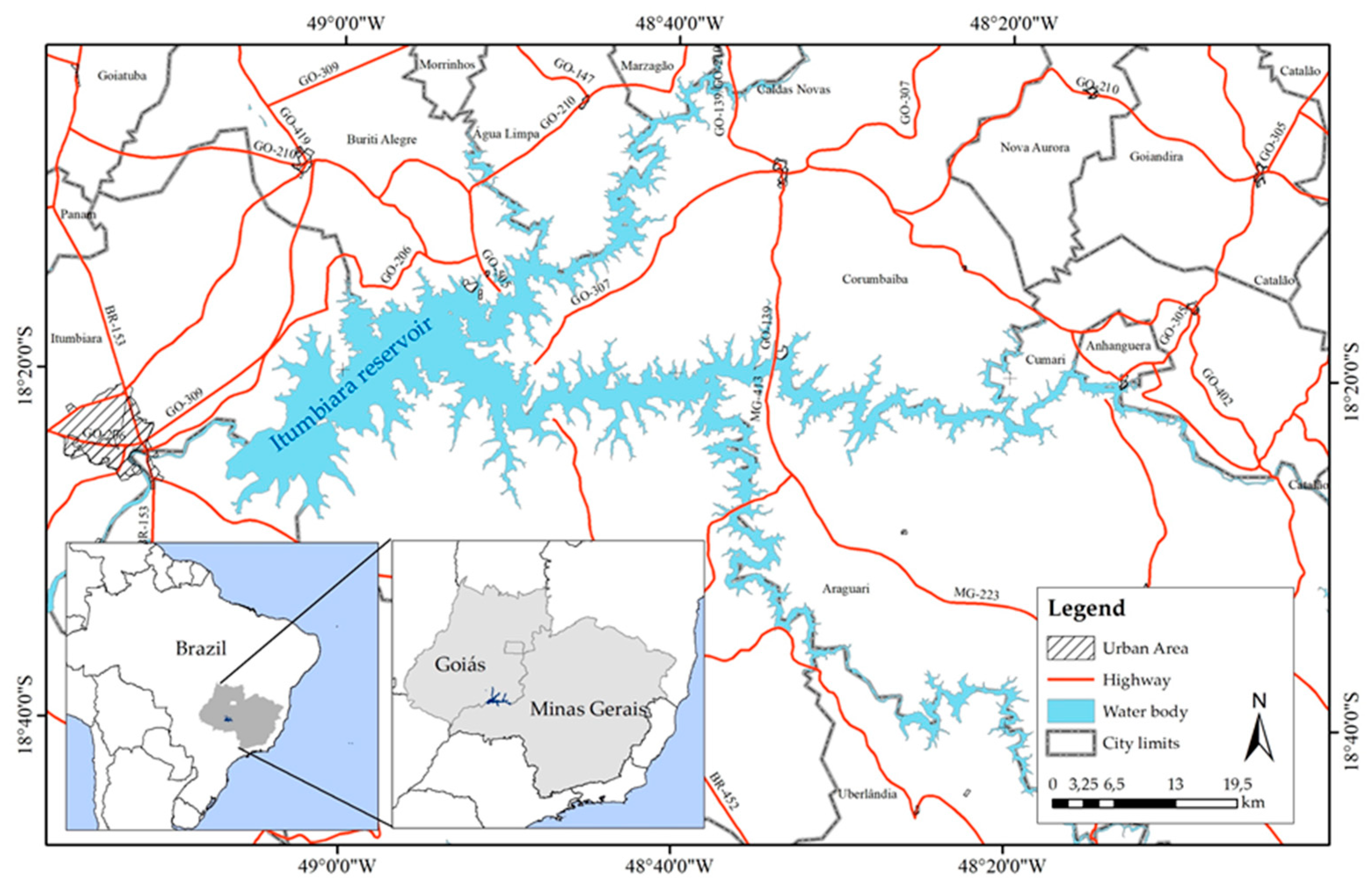
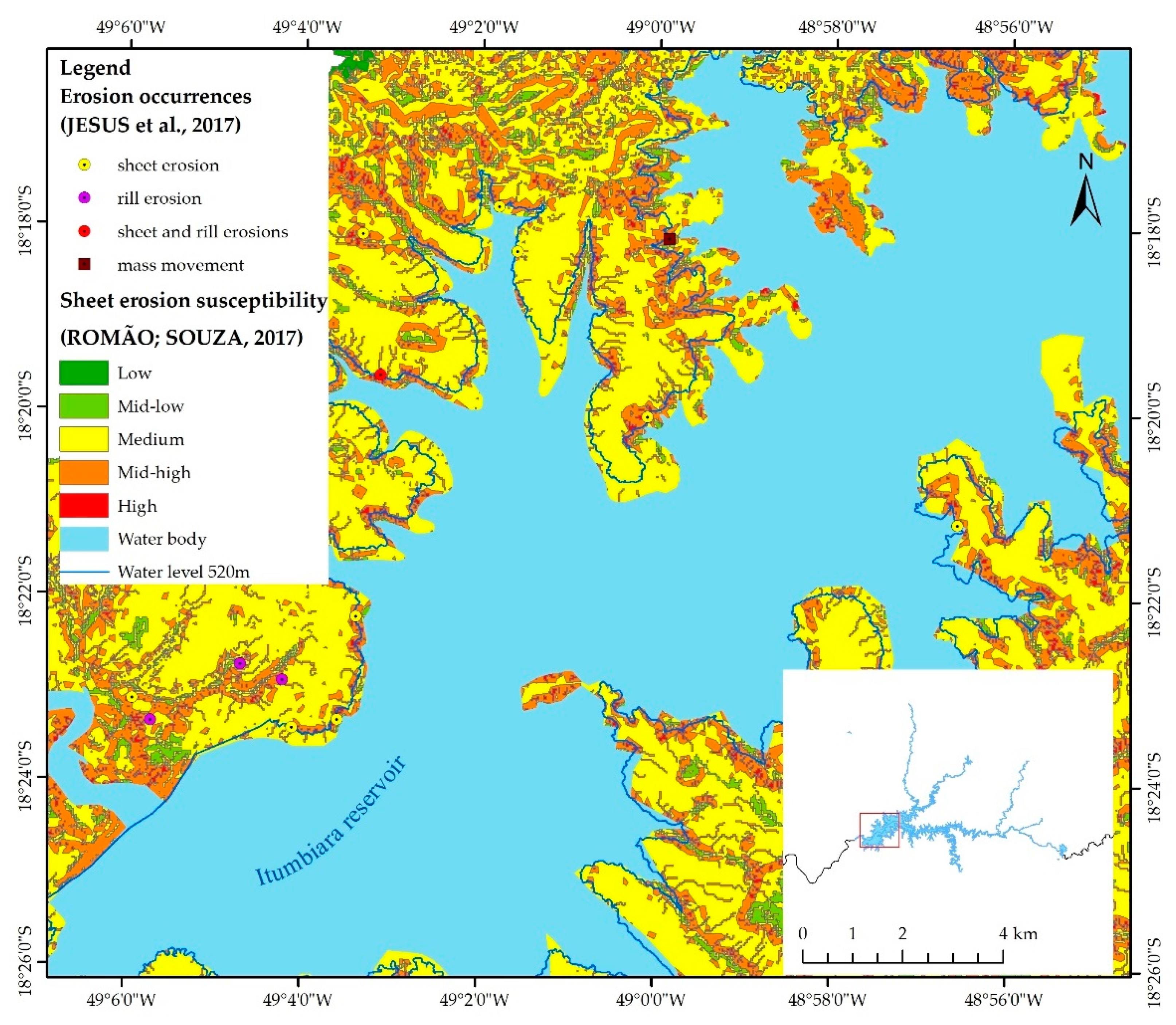
2.1. Study Area
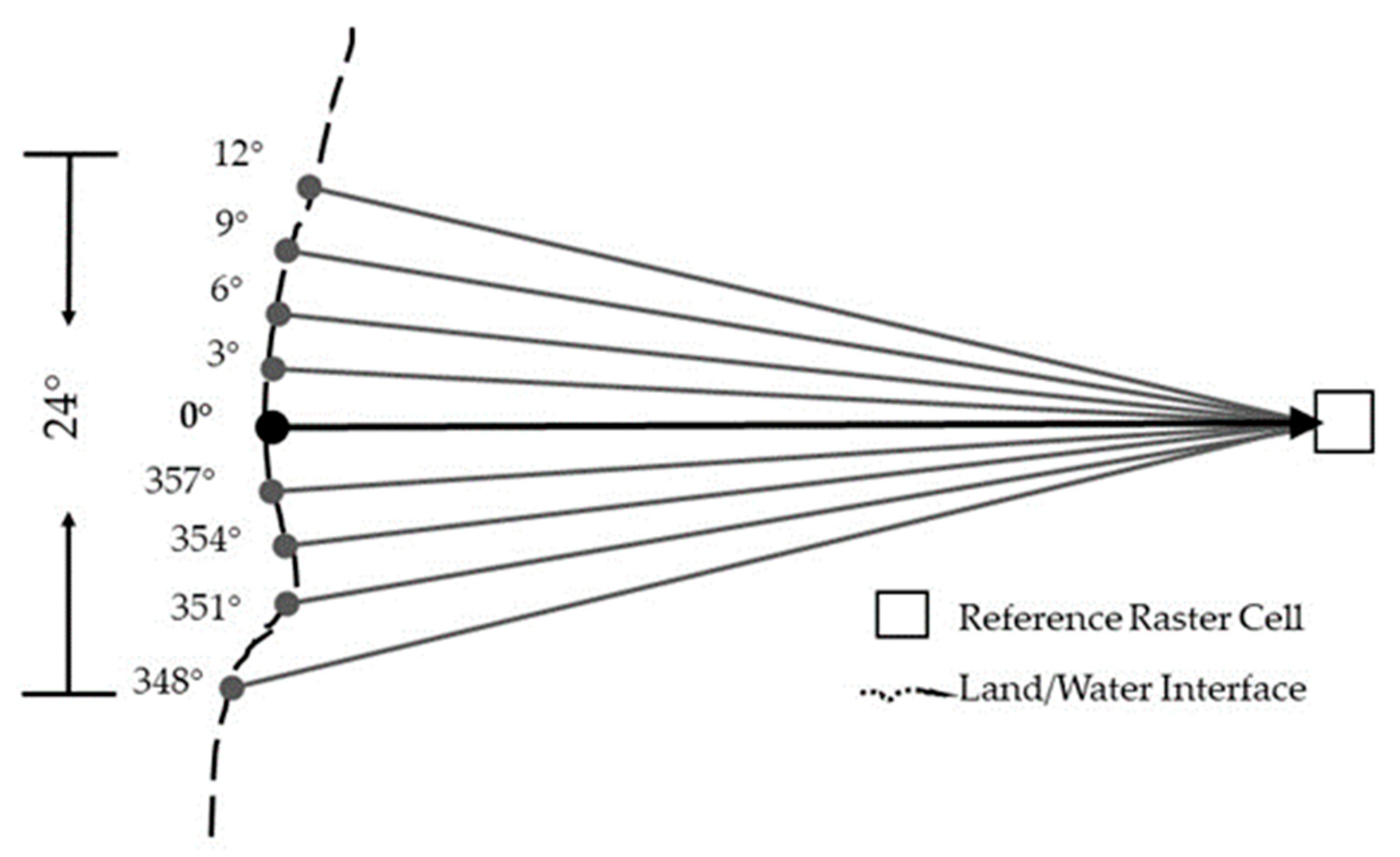
2.2. Wave Erosivity Potential
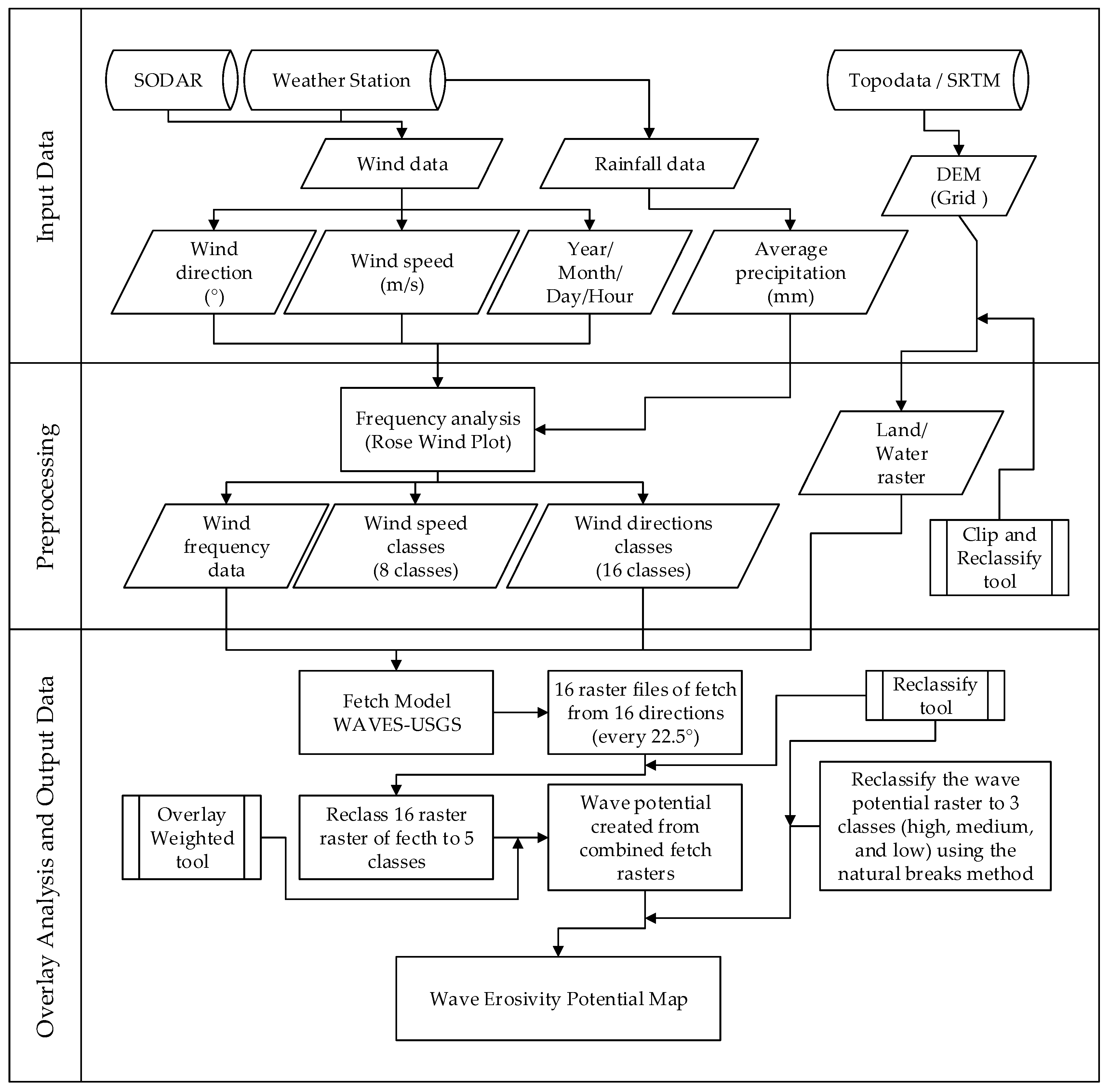
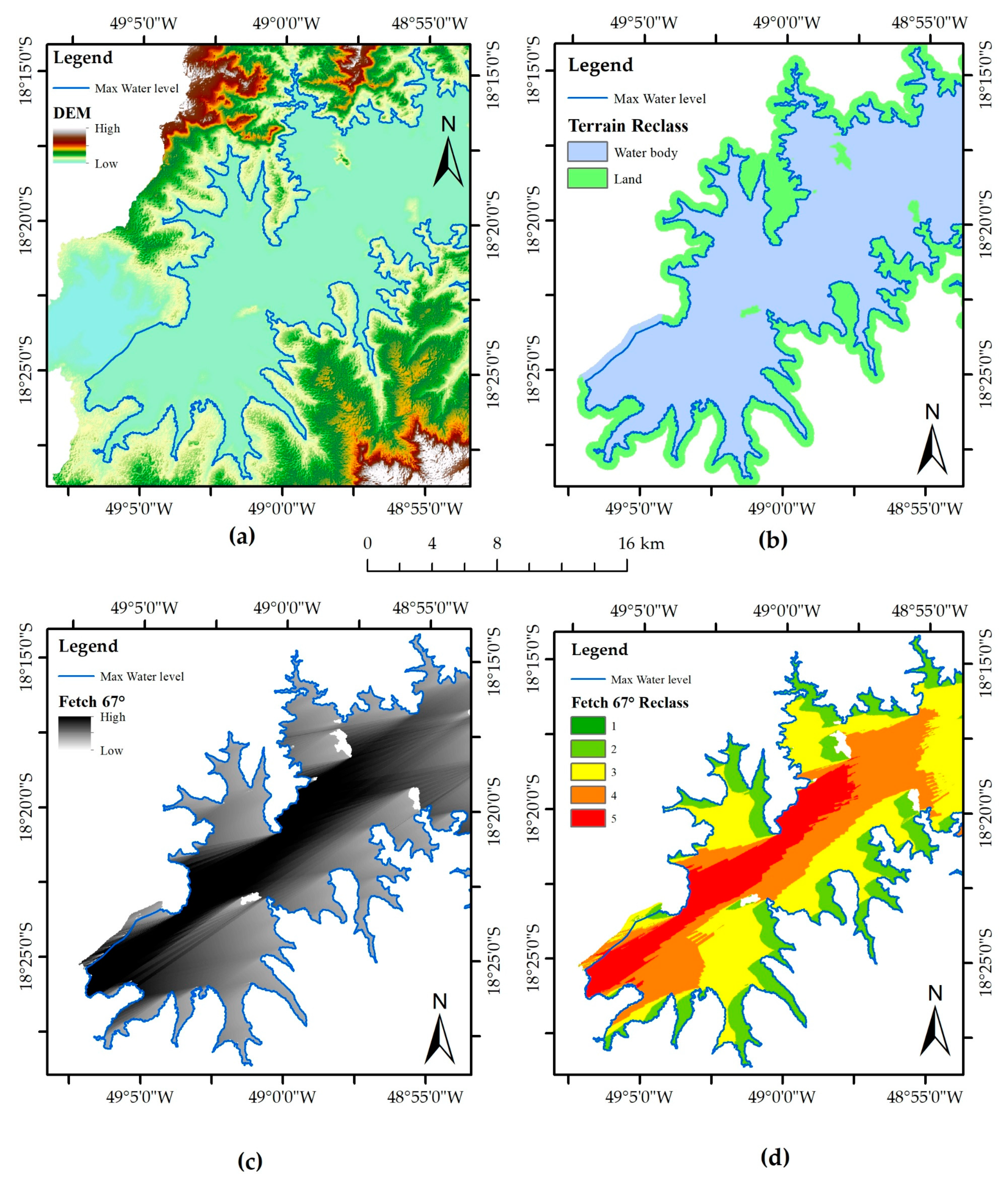
2.2.1. Input Data
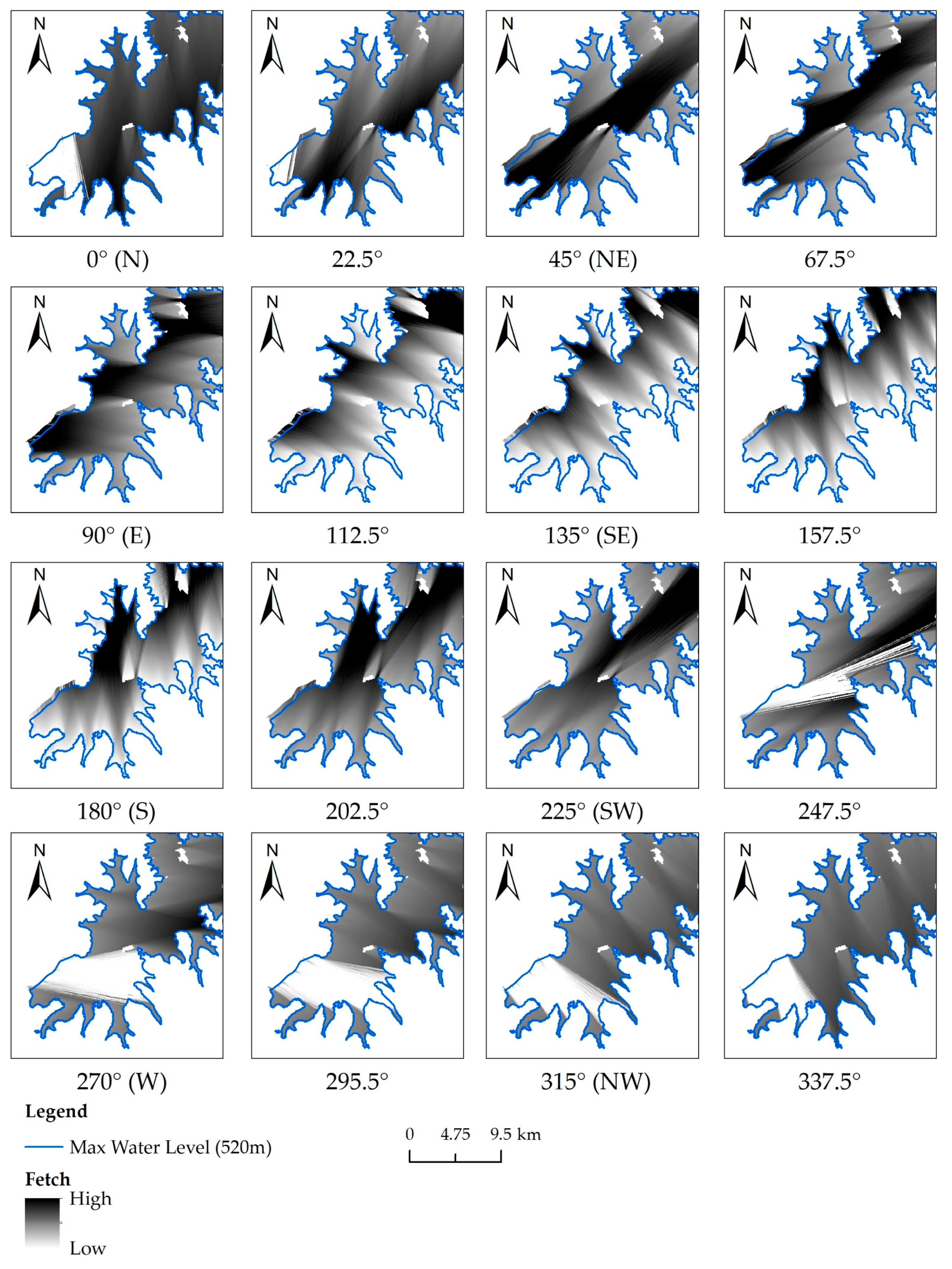
2.2.2. Preprocessing
2.2.3. Overlay Analysis and Output Data
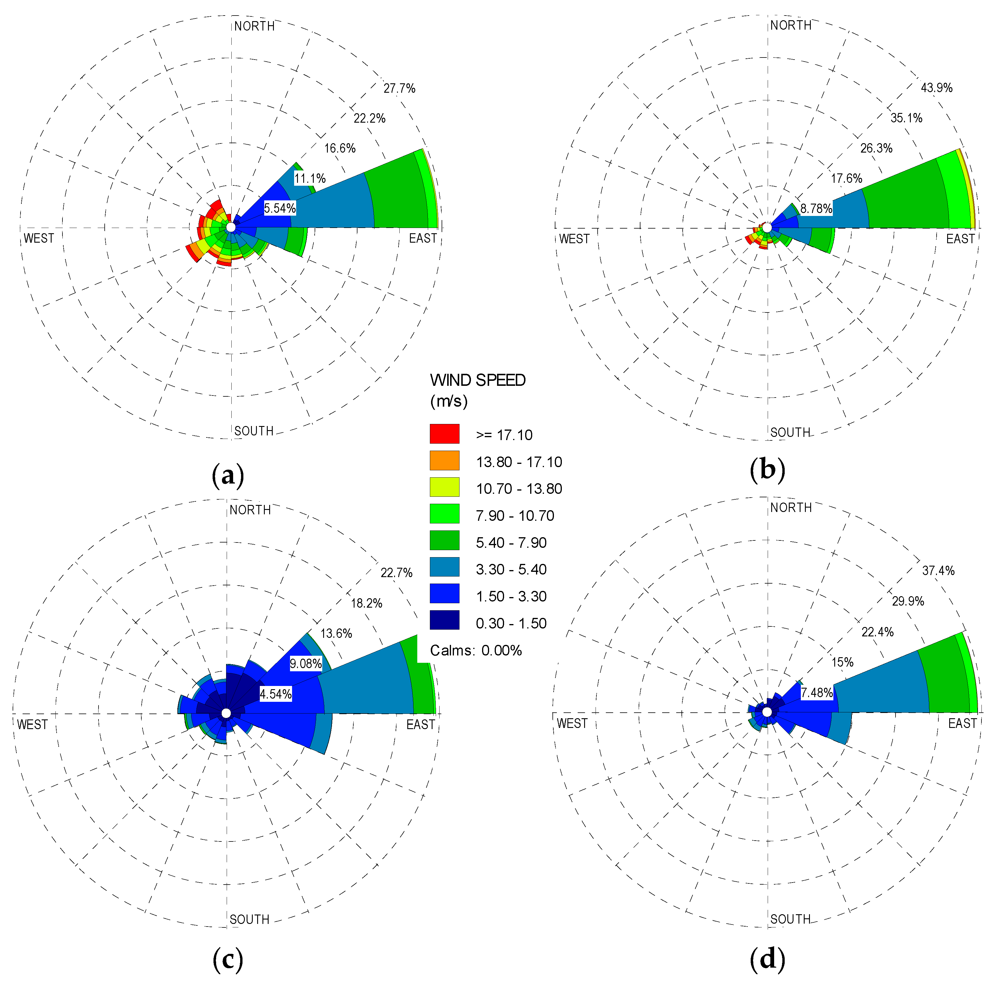
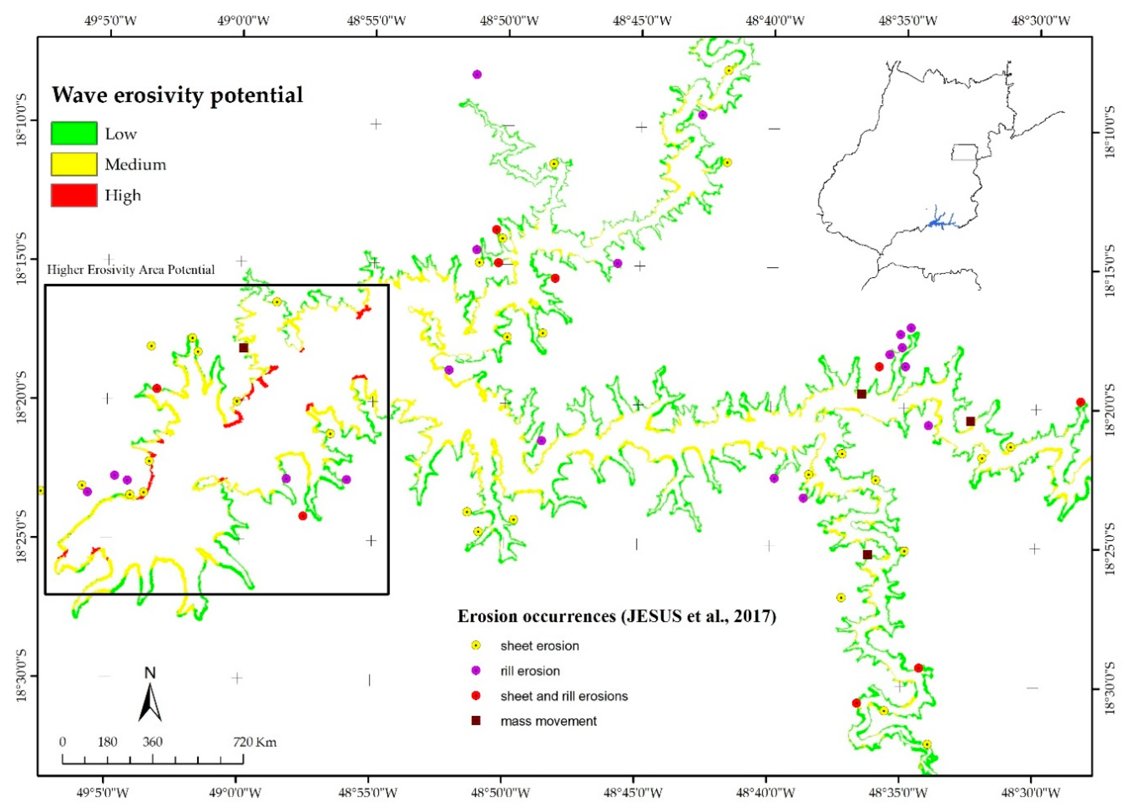
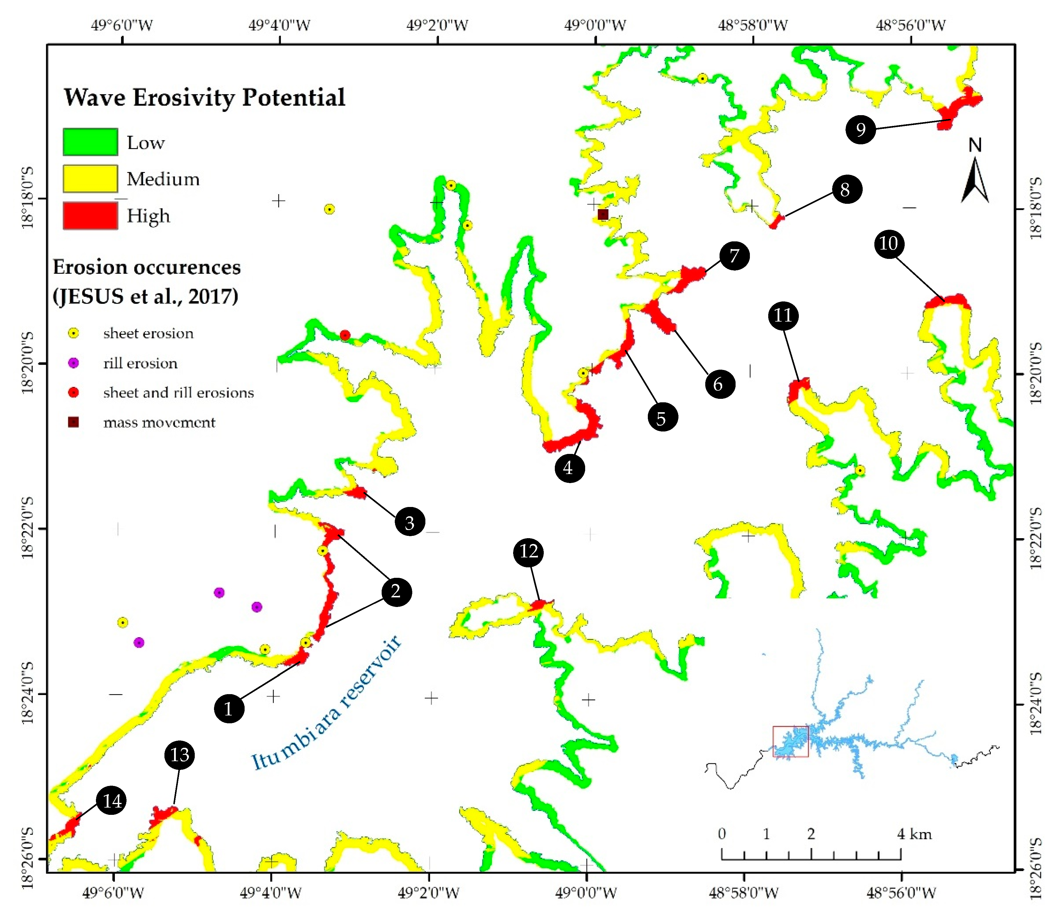
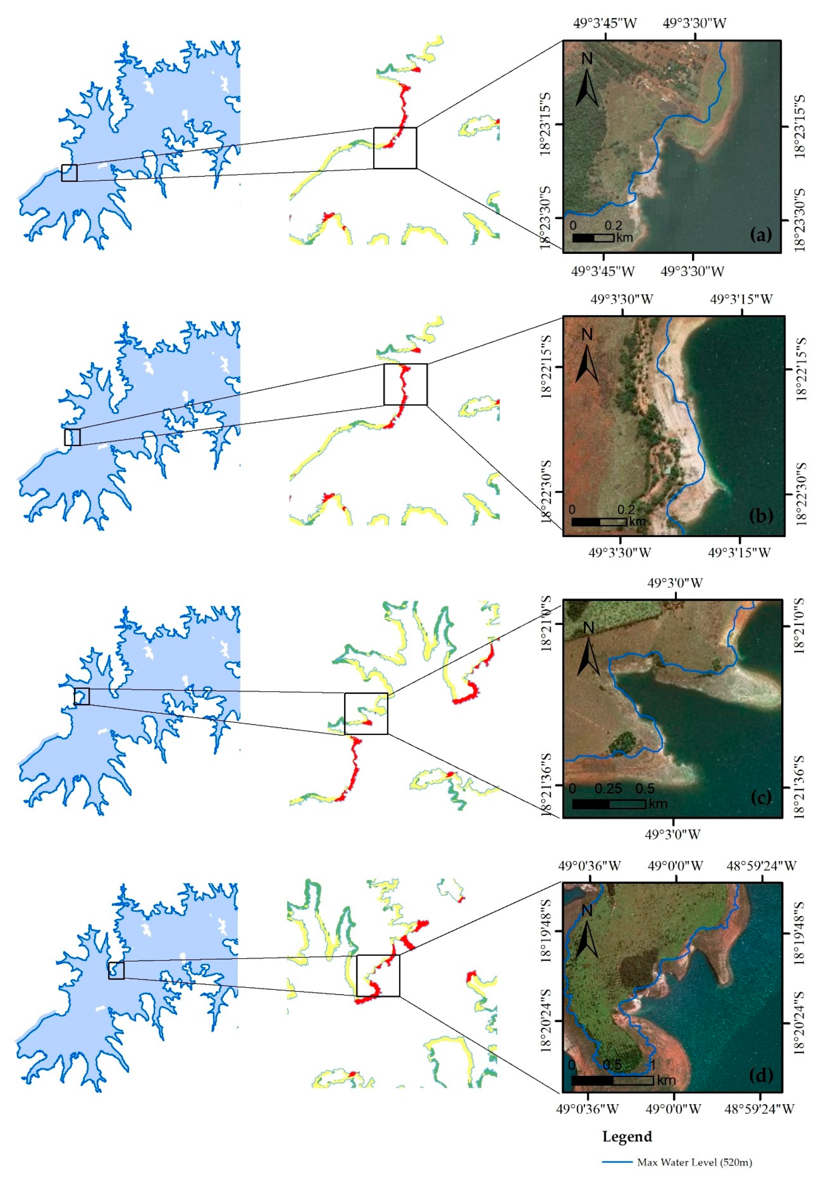
3. Results
4. Discussion
5. Conclusions
- The WAVES tool allows the examination of the reservoir shoreline erosion by wave potential and guide reservoir research and management.
- Higher wave erosivity potential areas must be examined with satellite imagery.
- In general, the wind anemometer and acoustic Doppler sensor are appropriate for estimating the wave erosivity potential.
- The method presented by Olson and Ventura [29] is applicable to reservoirs used as hydropower systems located in other countries.
Author Contributions
Funding
Acknowledgments
Conflicts of Interest
References
- Huang, C.-C.; Lai, J.-S.; Lee, F.-Z.; Tan, Y.-C. Physical Model-Based Investigation of Reservoir Sedimentation Processes. Water 2018, 10, 352. [Google Scholar] [CrossRef]
- Edil, T.B. Erosion of Coastal Slopes and Landslides. In Proceedings of the Geo-Congress 2013, San Diego, CA, USA, 3–7 March 2013. [Google Scholar] [CrossRef]
- Zhang, Y.; Zhong, P.-A.; Chen, J.; Bing, J.; Xu, D.; Wang, M. Impacts of Climate Change and Human Activities on the Three Gorges Reservoir Inflow. Water 2017, 9, 957. [Google Scholar] [CrossRef]
- Enlow, H.K.; Fox, G.A.; Guertault, L. Watershed Variability in Streambank Erodibility and Implications for Erosion Prediction. Water 2017, 9, 605. [Google Scholar] [CrossRef]
- Ferreira, V.; Panagopoulos, T.; Andrade, R.; Guerrero, C.; Loures, L. Spatial variability of soil properties and soil erodibility in the Alqueva reservoir watershed. Solid Earth 2015, 6, 383–392. [Google Scholar] [CrossRef]
- Su, X.; Nilsson, C.; Pilotto, F.; Liu, S.; Shi, S.; Zenga, B. Soil erosion and deposition in the new shorelines of the Three Gorges Reservoir. Sci. Total Environ. 2017, 599–600, 1485–1492. [Google Scholar] [CrossRef]
- Kondolf, G.M.; Gao, Y.; Annandale, G.W.; Morris, G.L.; Jiang, E.; Zhang, J.; Cao, Y.; Carling, P.; Fu, K.; Guo, Q.; et al. Sustainable sediment management in reservoirs and regulated rivers: Experiences from five continents. Earth’s Future 2014, 2, 256–280. [Google Scholar] [CrossRef]
- Esmaeili, T.; Sumi, T.; Kantoush, S.A.; Kubota, Y.; Haun, S.; Rüther, N. Three-Dimensional Numerical Study of Free-Flow Sediment Flushing to Increase the Flushing Efficiency: A Case-Study Reservoir in Japan. Water 2017, 9, 900. [Google Scholar] [CrossRef]
- Shumba, A.; Gumindoga, W.; Togarepi, S.; Masarira, T.P.; Chikuni, E. A remote sensing and GIS based application for monitoring water levels at Kariba dam. In Proceedings of the EAI International Conference for Research, Innovation and Development for Africa (ACRID), Victoria Falls, Zimbabwe, 20–21 June 2017. [Google Scholar] [CrossRef]
- Abera, F.F.; Asfaw, D.H.; Engida, A.N.; Melesse, A.M. Optimal Operation of Hydropower Reservoirs under Climate Change: The Case of Tekeze Reservoir, Eastern Nile. Water 2018, 10, 273. [Google Scholar] [CrossRef]
- Liu, H.; Deng, B.; Liu, Y.; Jiang, C.; Wu, Z.; Long, Y. Preliminary Numerical Analysis of the Efficiency of a Central Lake Reservoir in Enhancing the Flood and Drought Resistance of Dongting Lake. Water 2018, 10, 225. [Google Scholar] [CrossRef]
- Rahmani, V.; Kastens, J.H.; deNoyelles, F.; Jakubauskas, M.E.; Martinko, E.A.; Huggins, D.H.; Gnau, C.; Liechti, P.M.; Campbell, S.W.; Callihan, R.A.; et al. Examining Storage Capacity Loss and Sedimentation Rate of Large Reservoirs in the Central U.S. Great Plains. Water 2018, 10, 190. [Google Scholar] [CrossRef]
- Forsythe, K.W.; Schatz, B.; Swales, S.J.; Ferrato, L.J.; Atkinson, D.M. Visualization of Lake Mead Surface Area Changes from 1972 to 2009. ISPRS Int. J. Geo-Inf. 2012, 1, 108–119. [Google Scholar] [CrossRef]
- Schleiss, A.J.; Franca, M.J.; Juez, C.; De Cesare, G. Reservoir Sedimentation. J. Hydraul. Res. 2016. [Google Scholar] [CrossRef]
- Elçi, S.; Bor, A.; Çalışkan, A. Using numerical models and acoustic methods to predict reservoir sedimentation. Lake Reserv. Manag. 2009, 25, 297–306. [Google Scholar] [CrossRef]
- Gelagay, H.S. RUSLE and SDR Model Based Sediment Yield Assessment in a GIS and Remote Sensing Environment: A Case Study of Koga Watershed, Upper Blue Nile Basin, Ethiopia. Hydrol. Curr. Res. 2016, 7, 2–10. [Google Scholar] [CrossRef]
- Heathcote, A.J.; Filstrup, C.T.; Downing, J.A. Watershed Sediment Losses to Lakes Accelerating Despite Agricultural Soil Conservation Efforts. PLoS ONE 2013, 8, e53554. [Google Scholar] [CrossRef]
- Lin, C.Y.; Lin, W.T.; Chouc, W.C. Soil erosion prediction and sediment yield estimation: The Taiwan experience. Soil Tillage Res. 2002, 68, 143–152. [Google Scholar] [CrossRef]
- Shen, Z.Y.; Gong, Y.W.; Li, Y.H.; Hong, Q.; Xu, L.; Liu, R.M. A comparison of WEPP and SWAT for modeling soil erosion of the Zhangjiachong Watershed in the Three Gorges Reservoir Area. Agric. Water Manag. 2009, 96, 1435–1442. [Google Scholar] [CrossRef]
- Rohweder, J.; Rogala, J.T.; Johnson, B.L.; Anderson, D.; Clark, S.; Chamberlin, F.; Potter, D.; Runyon, K. Application of Wind Fetch and Wave Models for Habitat Rehabilitation and Enhancement Projects—2012 Update; USACE and USGS-UMESC: La Crosse, WI, USA, 2012; pp. 1–52.
- Menezes, A.V. Proposta Metodológica Para Estudo de Perda de Massa de Solos Situados em Bordas de Reservatório Devido ao Efeito de Ondas Por Meio de um Canal Hidráulico. Masters’s Thesis, University of Goiás, Goiânia, Brazil, 2018. (In Portuguese). [Google Scholar]
- Zheng, J.-W.; Jia, Y.-G.; Liu, X.-L.; Sjan, H.-X.; Zhang, M.-S. Experimental study of the variation of sediment erodibility under wave-loading conditions. Ocean Eng. 2013, 68, 14–26. [Google Scholar] [CrossRef]
- Sandford, L.P.; Gao, J. Influences of Wave Climate and Sea Level on Shoreline Erosion Rates in the Maryland Chesapeake Bay. Estuar. Coast. 2018, 41, 19–37. [Google Scholar] [CrossRef]
- Marques, M.; Andrade, F.O.; Guetter, A.K. Conceito do Campo de Fetch e sua Aplicação ao Reservatório de Itaipu. RBRH 2013, 18, 243–253. (In Portuguese) [Google Scholar] [CrossRef]
- Fonseca, L.A.M.; Lani, J.L.; Fernandes Filho, E.I.; Marques, E.A.G.; Ferreira, W.P.M. Avaliação da erodibilidade de um cambissolo de Juiz de Fora, Minas Gerais. Geotecnia 2016, 136, 143–156. (In Portuguese) [Google Scholar] [CrossRef]
- Mattosinho, G.O. Dissipação de Energia de Ondas Geradas por Vento em Reservatórios de Barragens, Devido à Presença de Vegetação. Masters’s Thesis, UNESP, Ilha Solteira, Brazil, 2016. (In Portuguese). [Google Scholar]
- Kaliraj, S.; Chandrasekar, N.; Magesh, S. Impacts of wave energy and littoral currents on shoreline erosion/accretion along the south-west coast of Kanyakumari, Tamil Nadu using DSAS and geospatial technology. Environ. Earth Sci. 2014, 71, 4523–4542. [Google Scholar] [CrossRef]
- Bheeroo, R.A.; Chandrasekar, N.; Kaliraj, S.; Magesh, N.S. Shoreline change rate and erosion risk assessment along the Trou Aux Biches–Mont Choisy beach on the northwest coast of Mauritius using GIS-DSAS technique. Environ. Earth Sci. 2016, 75, 1–12. [Google Scholar] [CrossRef]
- Olson, E.R.; Ventura, S.J. Geospatial methods to examine shoreline erosion in the Chippewa Flowage: A case study. Lake Reserv. Manag. 2012, 28, 170–175. [Google Scholar] [CrossRef]
- Hernández, J.E.I. Avaliação da Fragilidade das Margens do Reservatório de Ilha Solteira—SP, Utilizando as Geotecnologias como Ferramentas de Análise Ambiental. Masters’s Thesis, UNESP, Ilha Solteira, Brazil, 2014. (In Portuguese). [Google Scholar]
- Luz, M.P.; Beevers, L.C.; Cuthbertson, A.J.S.; Medero, G.M.; Dias, V.S.; Nascimento, D.T.F. The Mitigation Potential of Buffer Strips for Reservoir Sediment Yields: The Itumbiara Hydroelectric Power Plant in Brazil. Water 2016, 8, 489. [Google Scholar] [CrossRef]
- Furnas Centrais Elétricas S/A. Aproveitamento Hidrelétrico de Itumbiara—Relatório Final do Projeto Básico—Volume I—Texto; n°. HE-161-R02-0975; HIDROSERVICE Engenharia Ltda: São Paulo, Brazil, 1974; pp. 1–55. (In Portuguese) [Google Scholar]
- Romão, P.A.; Souza, N.M. Aspectos geológicos e hidrogeológicos na deflagração e evolução da erosão hídrica em margens de reservatórios. In Erosão em Bordas de Reservatório, 1st ed.; Sales, M.M., Camapum de Carvalho, J., Mascarenha, M.M., Luz, M.P., Angelim, R.R., Souza, N.M., Eds.; Gráfica UFG: Goiânia, Brazil, 2017; pp. 153–170. ISBN 978-85-495-0118-9. (In Portuguese) [Google Scholar]
- Sales, M.M. Monitoramento e Estudo de Técnicas Alternativas na Estabilização de Processos Erosivos em Reservatórios de UHEs, 2nd Work Report; FUNAPE: Goiânia, Brazil, 2014; pp. 1–40. (In Portuguese) [Google Scholar]
- Manwell, J.F.; Mcgowan, J.G.; Roges, A.L. Wind Energy Explained: Theory, Design, and Application, 2nd ed.; John Willey and Sons Ltd.: West Sussex, UK, 2010; pp. 46–85. ISBN 978-0-470-01500-1. [Google Scholar]
- Topodata. Available online: http://www.dsr.inpe.br/topodata/ (accessed on 10 January 2018).
- The Beaufort Wind Force Scale. Available online: https://en.wind-turbine-models.com/winds (accessed on 28 August 2018).
- Jesus, A.S.; Sousa, M.S.; Nascimento, D.T.F.; Romão, P.A.; Camapum de Carvalho, J. A influência de aspectos geomorfológicos, de cobertura do solo e climáticos no surgimento e evolução de processos erosivos no entorno de reservatório. In Erosão em Bordas de Reservatório, 1st ed.; Sales, M.M., Camapum de Carvalho, J., Mascarenha, M.M., Luz, M.P., Angelim, R.R., Souza, N.M., Eds.; Gráfica UFG: Goiânia, Brazil, 2017; pp. 172–192. ISBN 978-85-495-0118-9. (In Portuguese) [Google Scholar]
- Kelley, N.D.; Jonkman, B.J.; Scott, G.N.; Pichugina, Y.L. Comparing Pulsed Doppler LIDAR with SODAR and Direct Measurements for Wind Assessment. In Proceedings of the AWEA’s 2007 WindPower Conference, Los Angeles, CA, USA, 3–6 June 2007; pp. 1–21. [Google Scholar]
- Lawson, D.E. Erosion of Northern Reservoir Shores, an Analysis et Application of Pertinent Literature; CRREL, Monograph 85-1; USACE: Hanover, NH, USA, 1985; pp. 35–37.
- Assireu, A.; Pimenta, F.; Souza, V. Assessment of wind power potential of hydroelectric reservoirs. In Energy Resources: Development, Distribution and Exploitation, 1st ed.; Alcantara, E.H., Ed.; INPE: Sao Paulo, Brazil, 2011; pp. 1–28. ISBN 978-1-61324-520-0. [Google Scholar]
- Assireu, A.; Pellegrini, C.C.; Pimenta, F. Intensificação do vento devido a influências do relevo: Evidências a partir de modelos numéricos e medidas in situ. Ciência e Natura 2013. (In Portuguese) [Google Scholar] [CrossRef]
- Pellegrini, C.C.; Neto, A.V.L.; Assis, J.V.B.; Assireu, A. Um Estudo Numérico da Intensificação do Vento em Reservatórios de Centrais Hidroelétricas da Região Sudeste do Brasil. Ciência e Natura 2016, 38, 197–203. (In Portuguese) [Google Scholar] [CrossRef]
- Li, Y.; Huang, T.; Ma, W. Correlation Analysis of Rainstorm Runoff and Density Current in a Canyon-Shaped Source Water Reservoir: Implications for Reservoir Optimal Operation. Water 2018, 10, 447. [Google Scholar] [CrossRef]
- De Souza Dias, V.; Pereira da Luz, M.; Medero, G.M.; Tarley Ferreira Nascimento, D. An Overview of Hydropower Reservoirs in Brazil: Current Situation, Future Perspectives and Impacts of Climate Change. Water 2018, 10, 592. [Google Scholar] [CrossRef]
- Northwest Regional Planning Commission. Shoreline Stabilization Handbook for Lake Champlain and Other Inland Lakes; Lake Champlain Basin Program and US Environmental Protection Agency: St. Albans, VT, USA, 2004; pp. 1–49. ISBN 0-9754546-0-9.


| Force | Wind Speed (m/s) | Wind Descriptive Terms |
|---|---|---|
| 0 | <0.3 | Calm |
| 1 | 0.3 to 1.5 | Light air |
| 2 | 1.6 to 3.3 | Light breeze |
| 3 | 3.4 to 5.4 | Gentle breeze |
| 4 | 5.5 to 7.9 | Moderate breeze |
| 5 | 8.0 to 10.7 | Fresh breeze |
| 6 | 10.8 to 13.8 | Strong breeze |
| 7 | 13.9 to 17.1 | High wind |
| 8 | ≥17.1 | Gale |
| Class | m | km | (%) |
|---|---|---|---|
| Low | 1,088,811 | 1089 | 64% |
| Medium | 590,483 | 590 | 34% |
| High | 33,820 | 34 | 2% |
© 2019 by the authors. Licensee MDPI, Basel, Switzerland. This article is an open access article distributed under the terms and conditions of the Creative Commons Attribution (CC BY) license (http://creativecommons.org/licenses/by/4.0/).
Share and Cite
Vilhena, R.M.; Mascarenha, M.M.d.A.; Sales, M.M.; Romão, P.d.A.; Luz, M.P.d. Estimating the Wind-Generated Wave Erosivity Potential: The Case of the Itumbiara Dam Reservoir. Water 2019, 11, 342. https://doi.org/10.3390/w11020342
Vilhena RM, Mascarenha MMdA, Sales MM, Romão PdA, Luz MPd. Estimating the Wind-Generated Wave Erosivity Potential: The Case of the Itumbiara Dam Reservoir. Water. 2019; 11(2):342. https://doi.org/10.3390/w11020342
Chicago/Turabian StyleVilhena, Ricardo Moreira, Márcia Maria dos Anjos Mascarenha, Maurício Martines Sales, Patrícia de Araújo Romão, and Marta Pereira da Luz. 2019. "Estimating the Wind-Generated Wave Erosivity Potential: The Case of the Itumbiara Dam Reservoir" Water 11, no. 2: 342. https://doi.org/10.3390/w11020342
APA StyleVilhena, R. M., Mascarenha, M. M. d. A., Sales, M. M., Romão, P. d. A., & Luz, M. P. d. (2019). Estimating the Wind-Generated Wave Erosivity Potential: The Case of the Itumbiara Dam Reservoir. Water, 11(2), 342. https://doi.org/10.3390/w11020342