Article

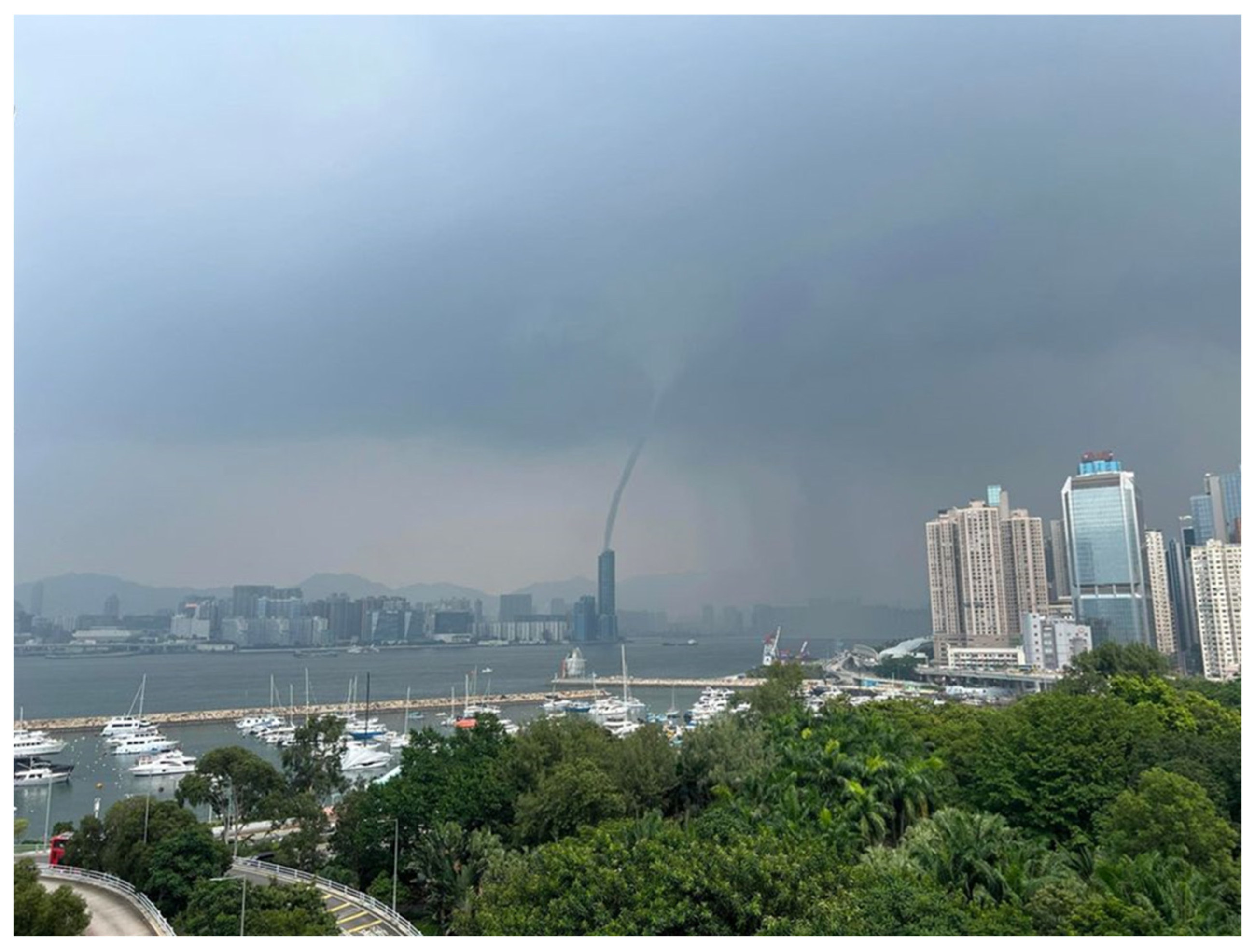
Possible Mechanisms Contributing to the Occurrence of a Waterspout in Victoria Harbour, Hong Kong, on 28 September 2024: Observational and Numerical Studies

Hong Kong Observatory, Hong Kong, China
*
Author to whom correspondence should be addressed.
Atmosphere 2025, 16(7), 868; https://doi.org/10.3390/atmos16070868
Submission received: 20 June 2025 / Revised: 15 July 2025 / Accepted: 15 July 2025 / Published: 16 July 2025
(This article belongs to the Section Meteorology)

Abstract

A numerical simulation experiment is conducted to study the first-ever waterspout observed in Victoria Harbour, Hong Kong, in 2024, namely, a mesoscale meteorological model with a spatial resolution of 200 m coupled with a computational fluid dynamics model with a spatial resolution of 4 m. It is found that the simulation could reproduce the observed wind field near the surface reasonably well, as well as the location of the waterspout and showers, as shown in the weather image. By conducting simulations with and without buildings, it is found that the inclusion of buildings is essential for the successful reproduction of the flow fields near the surface and up to several hundred metres high. This may suggest that urbanization plays a role in the occurrence of this waterspout. The resultant horizontal vorticity is then stretched by strong vertical motion at around 850 hPa, resulting in the waterspout, though no closed circulation could be simulated at the location of the waterspout. Moreover, the cyclonic feature for the flow field near the surface has a time lag of about 30 min compared with the actual waterspout occurrence. Nonetheless, the simulation is considered to be generally satisfactory and provides useful insight into the occurrence of the waterspout.

1. Introduction

A fair-weather waterspout was recorded for the first time in Victoria Harbour, Hong Kong, on 28 September 2024. An observational study was conducted for this rare event in [1]. As shown in the observational data, one important mechanism for the occurrence of the waterspout was the convergence of the prevailing westerly winds over the Harbour with the arrival of the easterly winds. The horizontal vorticity might be lifted by the convective development, as shown by the rather high instability of the atmosphere and the development of showers in the weather radar images.
It is also shown that the 2 km mesoscale meteorological Weather Research and Forecasting (WRF) model [2] satisfactorily captured the horizontal vorticity and the convective development [1]. Building upon the findings in [1], this work seeks to refine our understanding by probing finer-scale phenomena through a nested high-resolution modelling approach. In particular, our study couples a 200 m WRF simulation with a 4 m computational fluid dynamics (CFD) model (PALM), including explicit building information. Such high-resolution nesting enables us to investigate the sub-kilometre, urban influences on atmospheric dynamics and near-surface convergence that may be critical for waterspout formation. As such, the current study aims to provide more detailed insights into the role of microscale flow features and urbanization—mechanisms that could not be fully resolved in the earlier 2 km framework.
WRF has been run routinely at a spatial resolution of 200 m for the whole of Hong Kong by the Hong Kong Observatory (HKO). The 200 m WRF is then nested with a CFD model, PALM, with a spatial resolution of 4 m and the inclusion of the buildings of urban areas of Hong Kong. The nesting of a mesoscale meteorological model with PALM has been successfully applied in Hong Kong in the study of building-induced airflow disturbances at the Hong Kong International Airport, such as [3], and tropical cyclone situations at a bridge, as in [4]. According to the knowledge of the authors of this manuscript, this setup is used for the first time in a real-life case study of a waterspout. Though the waterspout could not be directly simulated due to its tiny size, the WRF-PALM-coupled simulation could capture the favourable environment for waterspout formation. By comparing simulations with and without buildings, urbanization was found to contribute significantly to the near-surface convergence and might enhance the waterspout formation.

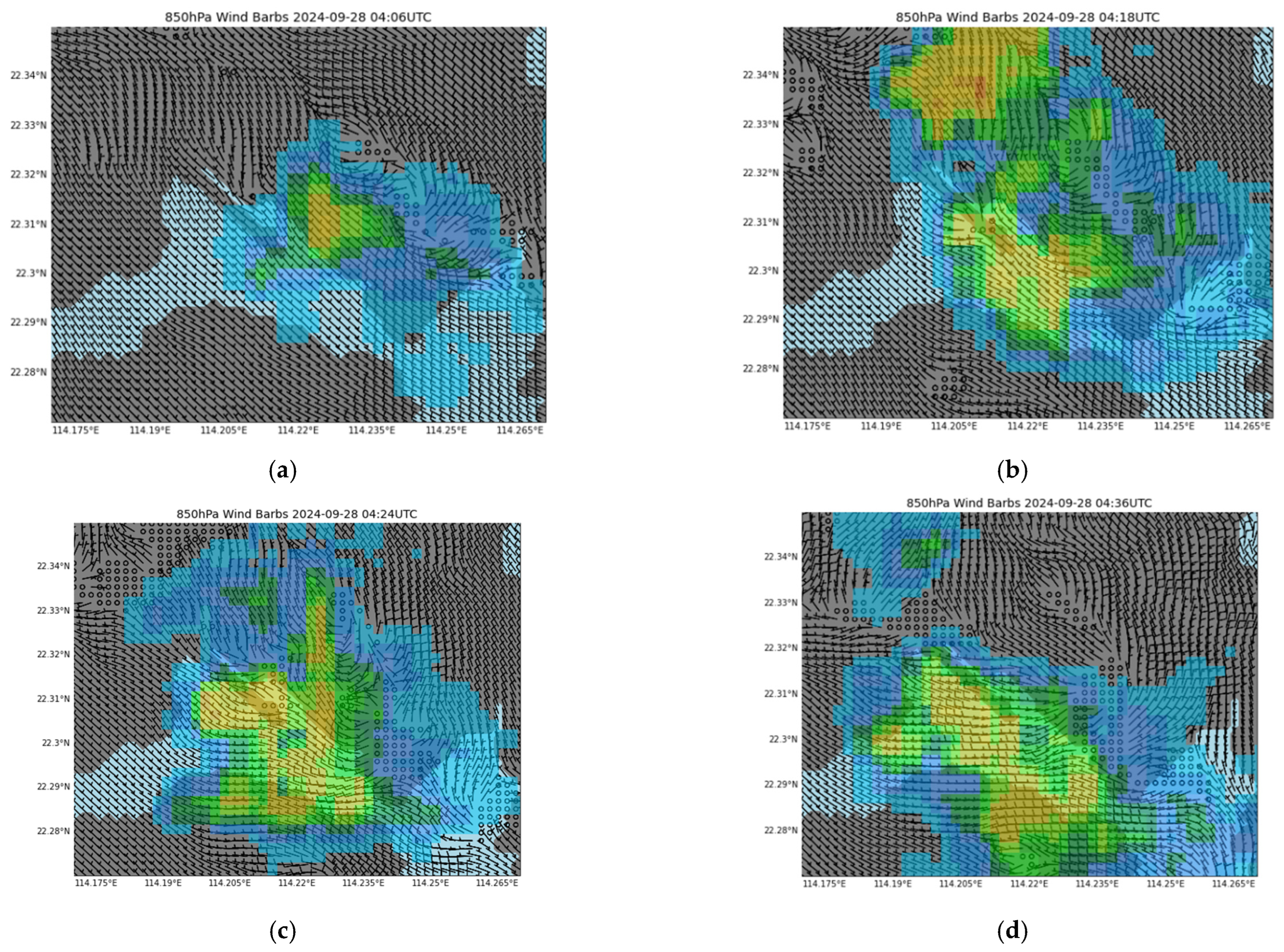
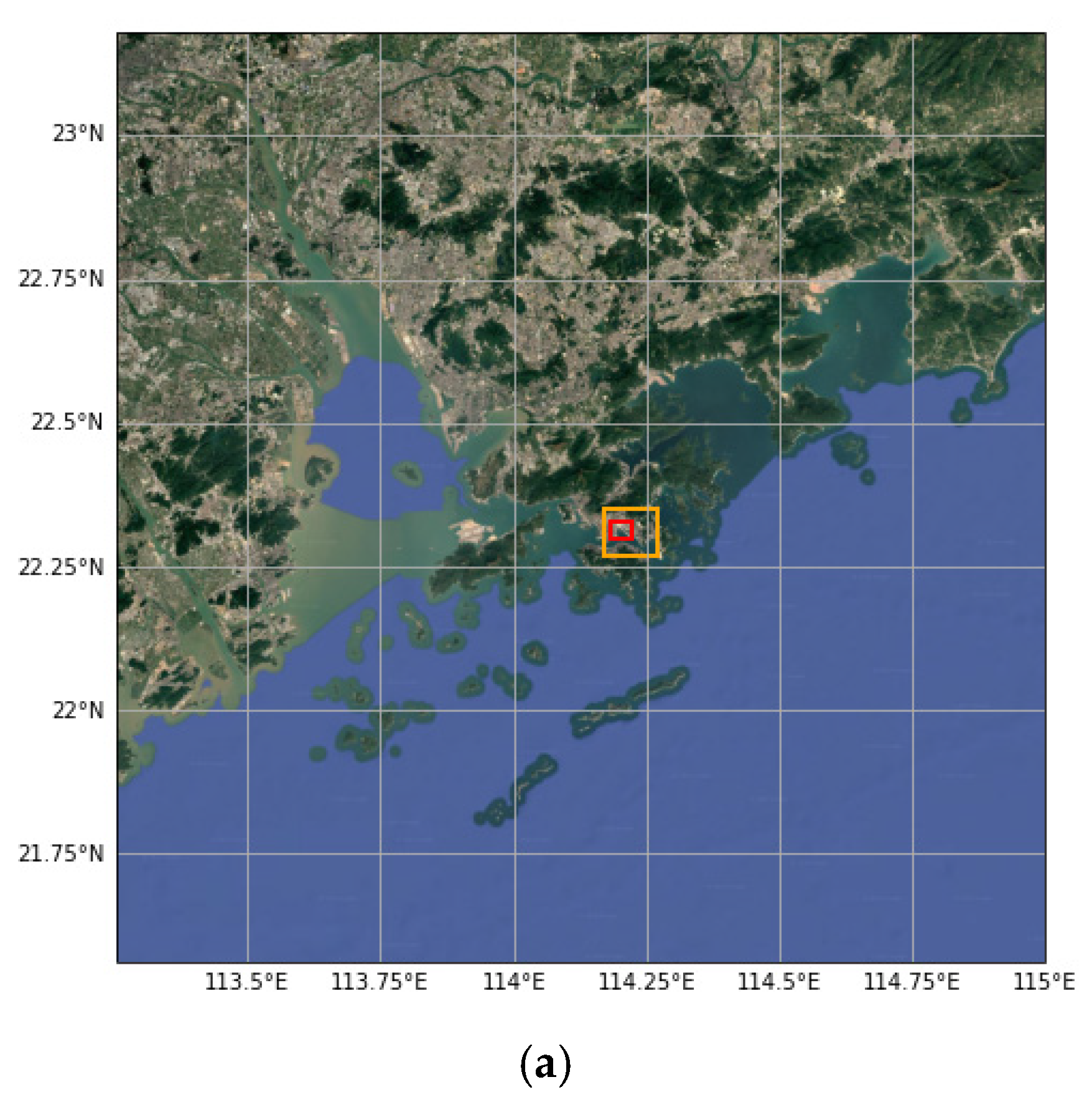
2. Observational Data
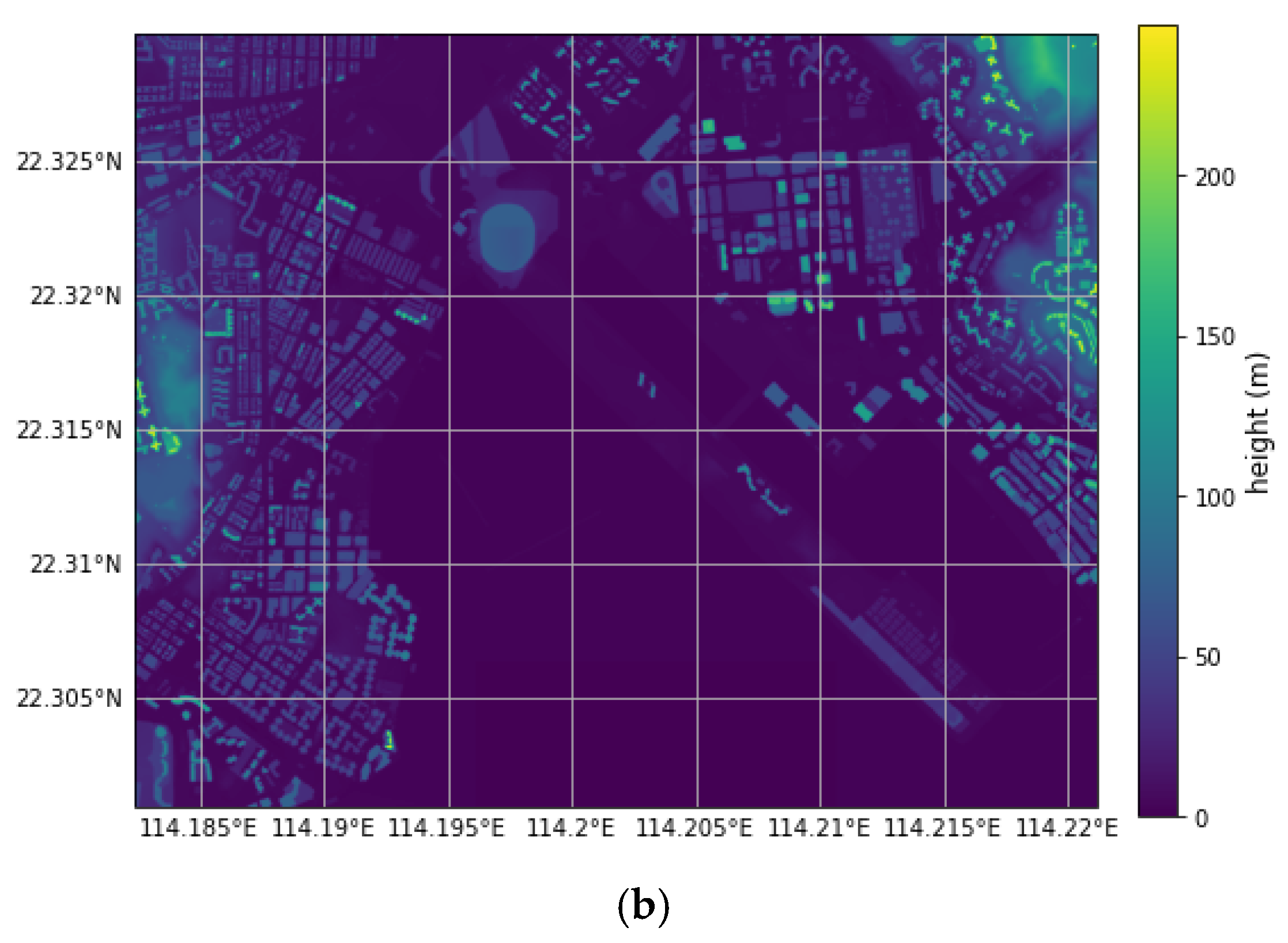
Figure 1 is a photo taken at the eastern coast of Hong Kong Island to the north at around 12:29 p.m. on 28 September 2024. In addition to the waterspout, there was also an area of showers to the east. As discussed in [1], the waterspout’s circular rotating region over the water had a size of about 40 to 50 m, while the air column aloft had a size of 20 to 30 m. Accurately simulating a feature with such small spatial scales remains extremely challenging, if not infeasible, even with the use of CFD at a horizontal grid spacing of 4 m. Nevertheless, the enhanced resolution may help to reveal more detailed flow structures and thereby offer deeper insights into the waterspout development process.
The surface wind observations around Victoria Harbour at noon time on 28 September 2024 are shown in Figure 2. The trajectory, with the starting and ending points marked by red circles, is also shown in Figure 2. In addition to the waterspout, there was also an area of showers to the east, as shown in Figure 1. The cold outflows associated with downdrafts from the showers to the east might also play a role in triggering or enhancing the waterspout development. To illustrate this, the 3 h temperature time-tendency perturbations, TP3, were also plotted in Figure 2 (blue numbers). This metric evaluates the 3 h temperature variation at each station relative to the average 3 h variation over the analysis domain, thereby filtering out larger-scale temperature trends (e.g., diurnal heating/natural temperature gradients) and reflecting the temperature change due to local convective development. TP3 values were already negative to the east of Hung Hom prior to the event (Figure 2a), likely owing to earlier showers. The temperature drop became more pronounced at the Kai Tak Runway Park (blue numbers in the black circle) from TP3 = −1 at 12:10 p.m. (Figure 2a) to TP3 = −4 at 12:30 p.m. (Figure 2c), coinciding with stronger radar echoes over the region (Figure 3a–c). Thus, the cold outflow due to this local development might help to push the easterly winds westward into Victoria Harbour between 12:20 and 12:30 p.m., as the wind direction changes from westerly to easterly at the eastern coast of Hong Kong Island, thereby enhancing the surface convergence, which is consistent with the conceptual model discussed in [5]. The prevalence of the weak westerly winds and the arrival of the easterly winds are presented in [1]. One additional observation is the arrival of weak northerly winds from the north of the Hung Hom area. The convergence of weak westerly, northerly, and easterly winds may contribute towards the horizontal vorticity, a prerequisite for the occurrence of the waterspout.

3. Numerical Models

The 200 m WRF model is now operationally used by the HKO, with a focus on capturing fine-scale short-term weather prediction, such as low-level wind shear at the Hong Kong International Airport. The domain of the 200 m WRF simulation can be found in Figure 4a. The setup of the simulation in the current study largely follows that of [6], using a WDM 6-class scheme for microphysics [7] and the RRTMG schemes for both short- and longwave radiation [8]. No cumulus parameterization or planetary boundary-layer scheme is used in this setup. The Smagorinsky scheme is used to handle sub-grid mixing [9]. The Noah land surface model was applied [10] to model land–surface interaction. Terrain and land-use data come from the U.S. Geological Survey 3 s topography and MODIS land-use classification, with local adaptations to account for urbanization and changes in coastlines.
The PALM model is a parallelized large-eddy simulation (LES) model. In PALM, the non-hydrostatic filtered, incompressible Navier–Stokes equations in Boussinesq-approximated forms are solved [11,12,13]. The 1.5-order closure Deardorff model is used for turbulent parameterization [14]. For momentum advection and time stepping schemes, the fifth-order upwind momentum scheme [15] and third-order Runge–Kutta scheme [16] are used, respectively. Synthetic turbulence generation is also applied [17,18] to generate a turbulent inflow condition. The horizontal resolution in the PALM simulation is 4 m. The vertical resolution is initially 6 m, with a vertical stretch ratio of 1.08 applied starting from 50 m, and the maximum vertical grid size is limited to 24 m. The top of the PALM simulation domain is roughly 2500 m. The bulk cloud module with saturation adjustment, which converts the excess supersaturation into liquid water and neglects other microphysical processes, is adapted in this study. The simulation domain of PALM, along with the building heights within the domain, is illustrated in Figure 4b.
The 200 m WRF output provides initial and boundary conditions to PALM through a dynamic input file, which is generated using a Python script available on the official PALM website (v.3.1).

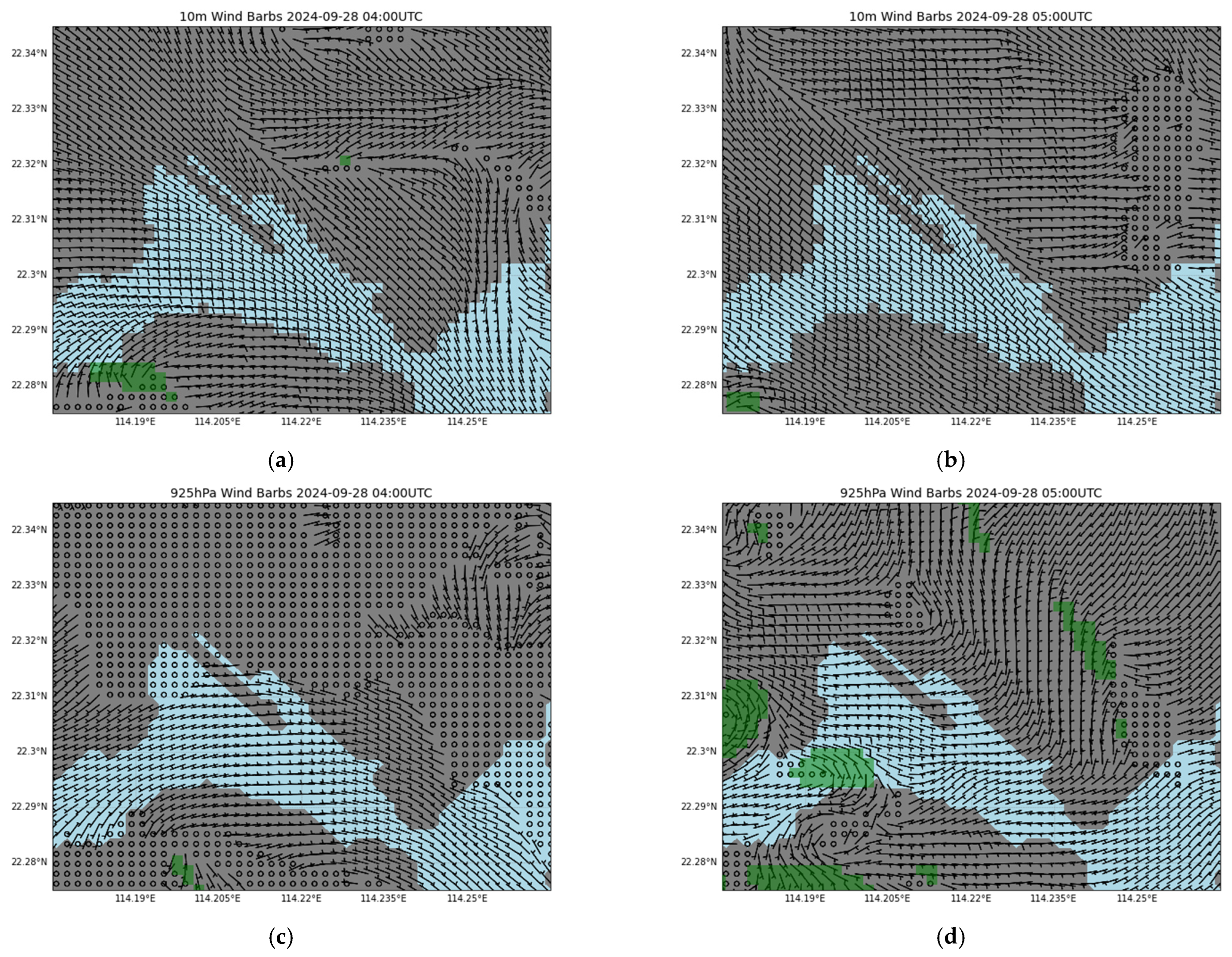
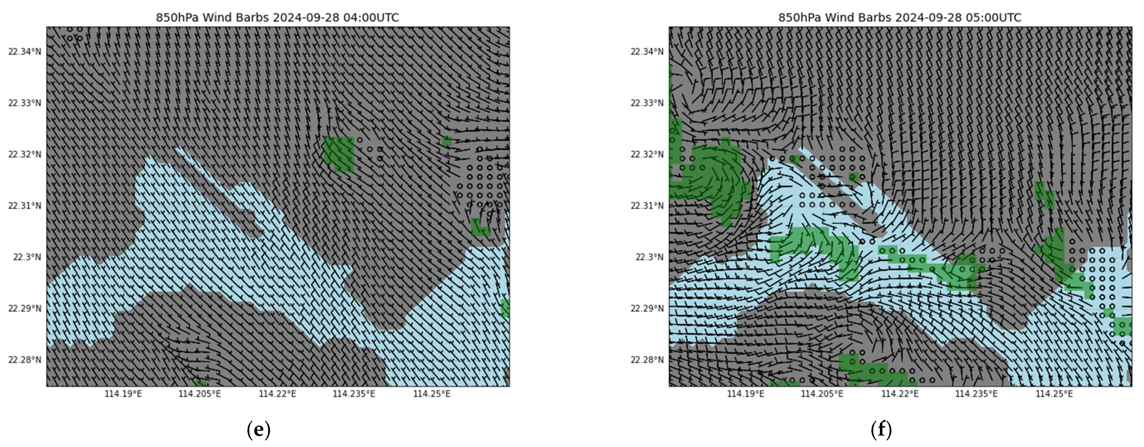
4. Results from 200 m WRF

Figure 5 shows the winds at different levels overlaid with horizontal vorticity from the 200 m WRF output. To simplify the plot, only regions with sufficiently large vorticity, larger than 0.005 s−1, are coloured green. The low-level cloud water mixing ratios (up to 1000 m) at the corresponding times were separately plotted in Figure 6 for clarity. Figure 5a,b show the 10 m winds at 12:00 and 13:00 (Hong Kong Time, UTC+8), respectively. WRF, with a resolution of 200 m, is found to capture the gradual prevalence of easterly wind over Victoria Harbour. However, there is no signature of convergence of the easterly wind with the background westerly wind.
At 925 hPa (Figure 5c,d) and 850 hPa (Figure 5e,f), the development of horizontal vorticity in association with the westerly winds to the west and easterly winds to the east was observed. There is an area with larger horizontal vorticity at 925 hPa and 850 hPa over Victoria Harbour just east of Hung Hom at 12:30 p.m. (Figure 5d,f). However, no significant low-level clouds were depicted in association with the low-level vorticity (Figure 6b). Thus, the 200 m resolution WRF does not capture the clouds/moisture well, as the microphysics parameterization scheme might not be suitable for this resolution. Hence, cold outflow in the simulation was not expected. This is one of the shortcomings of the current simulation setup, where future sensitivity tests can explore different microphysics schemes, or combine them with assimilated data of observed precipitation fields, to better reproduce the cloud and precipitation processes. Nevertheless, if we overlay the actual radar reflectivity with the model winds at 850 hPa (Figure 3a,b), it is observed that the clear signature of the horizontal vorticity is aligned with the stronger weather radar echoes.
Despite not fully capturing the near-surface convergence and the low-level moisture field well, the 200 m WRF might provide a reasonably good representation of the low-level flow field, particularly at 850 hPa, which appears to be relevant for waterspout formation by providing the potential updraft rotation aloft. Thus, the 200 m WRF could be used as the driving force for a higher resolution CFD simulation for understanding the more detailed dynamics of waterspout formation.

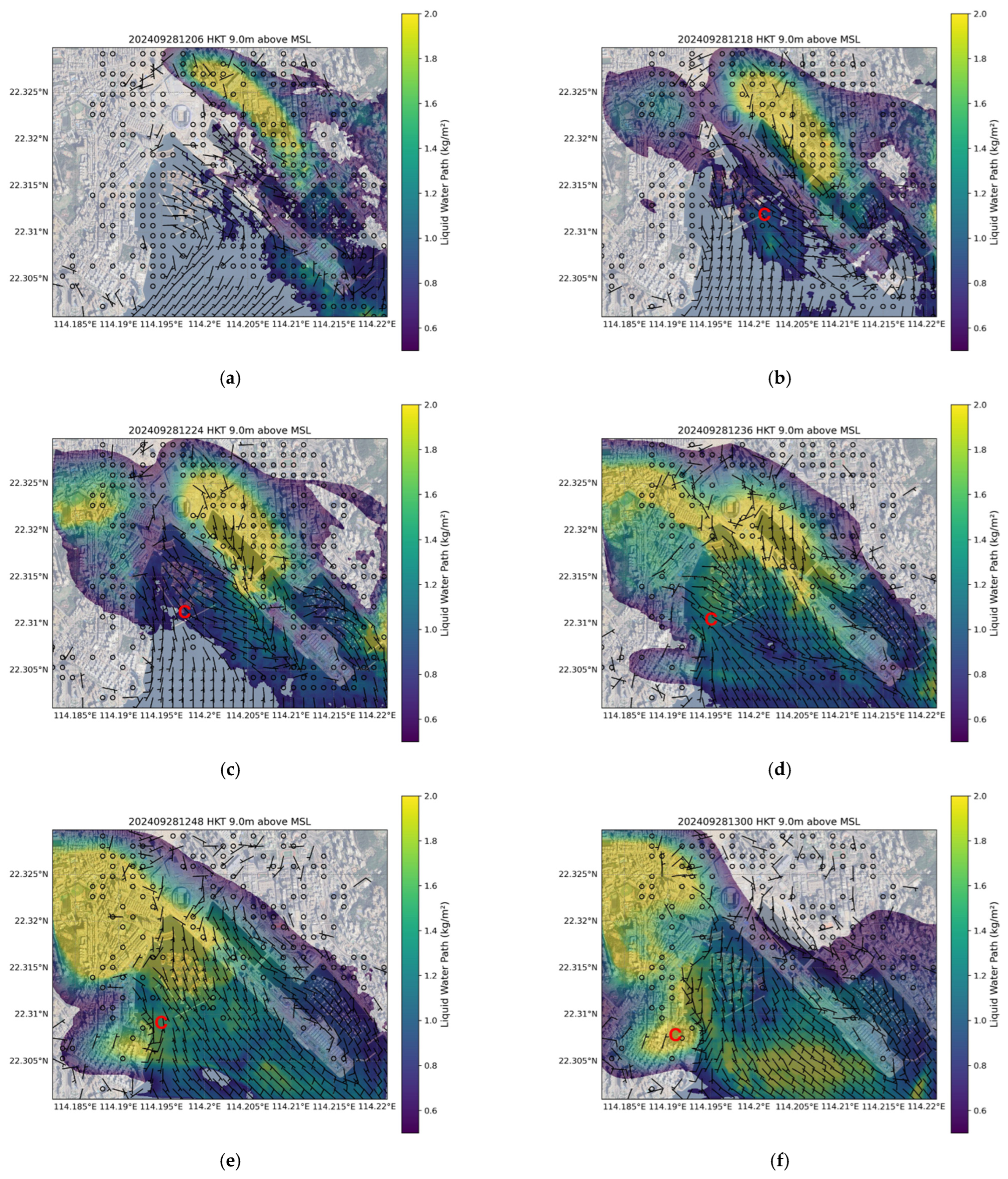
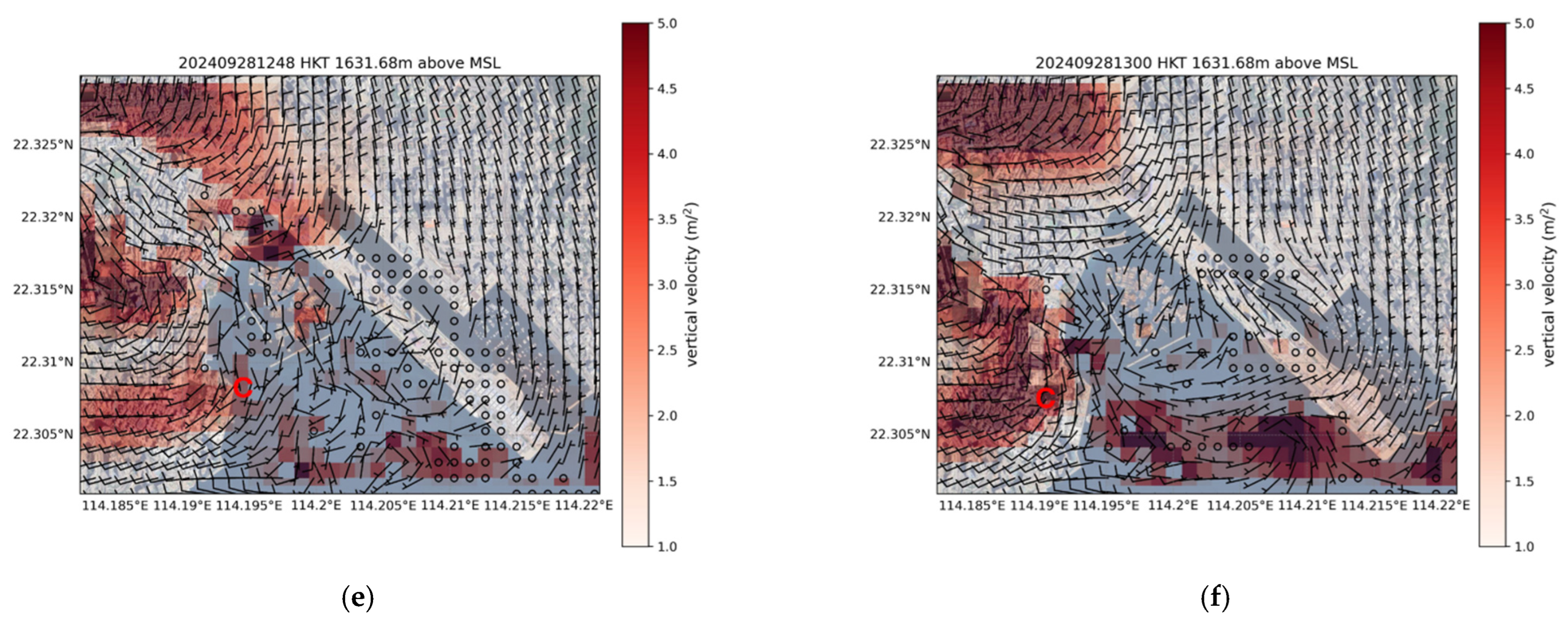
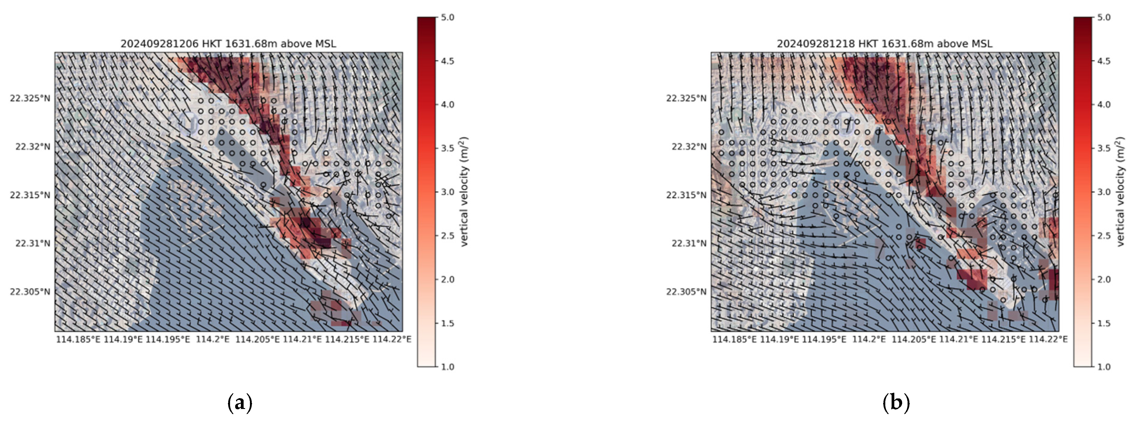
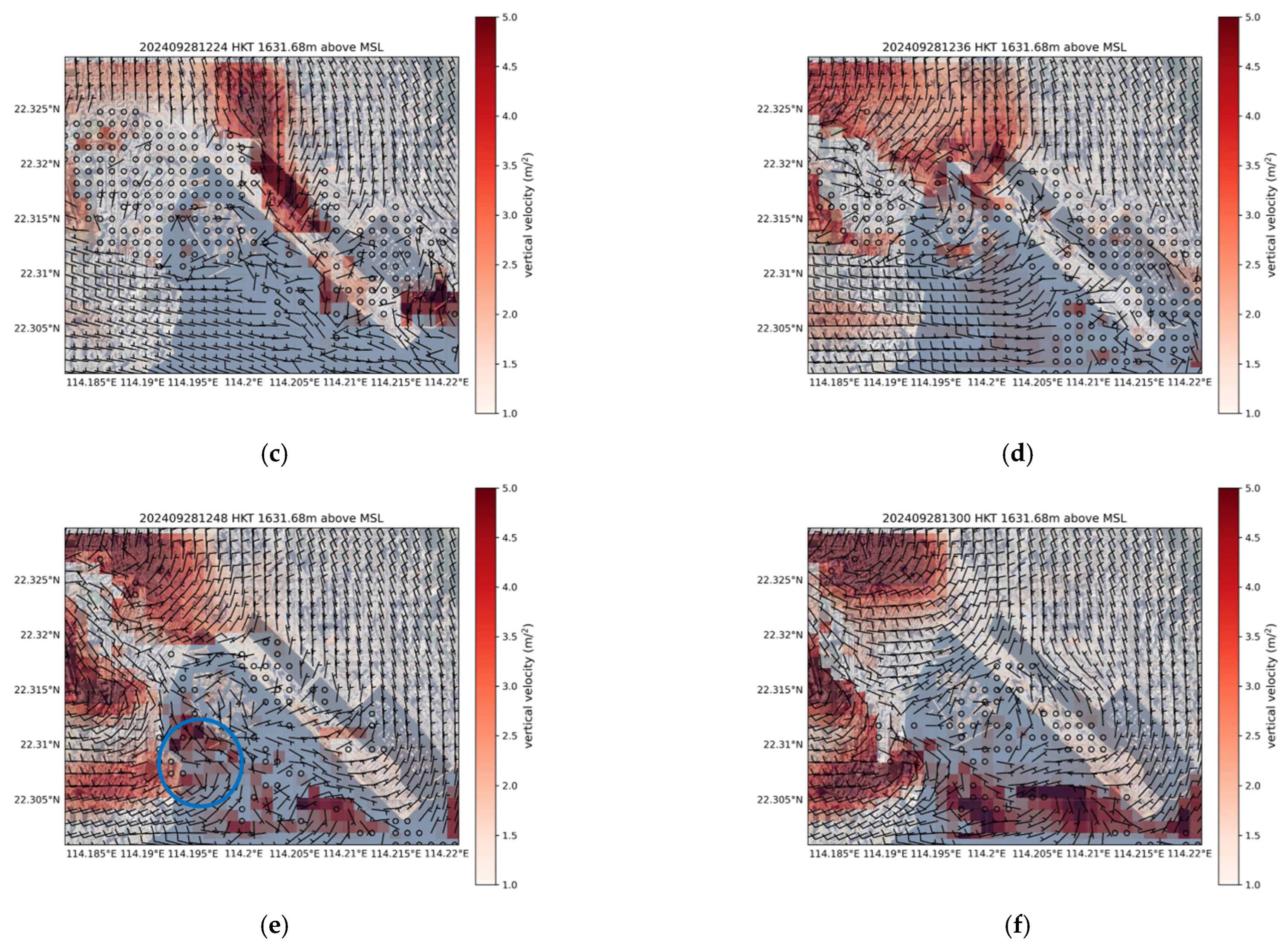
5. Results from 4 m PALM with Buildings

The simulated wind fields at 9 m above MSL overlaid with the simulated liquid water path at different time instances are shown in Figure 7. From Figure 7a,b, weak westerly winds prevail just to the east of Hung Hom, with the gradual setting in of easterly winds from the east. The convergence between westerly and easterly winds results in an area of a slightly higher liquid water path in Figure 7b. This area of the higher liquid water path gradually moves west in Figure 7c,d, and the cyclonic flow feature shows up nicely in Figure 7d, though there is no closed circulation as in the case of a waterspout. The liquid water path over the cyclonic feature further increases later in Figure 7e,f, with the “landfall” of the cyclonic feature over Hung Hom in Figure 7f.
Compared to the 200 m WRF results, the inclusion of buildings in the 4 m PALM simulation manages to capture the weak westerly winds over Victoria Harbour. Some weak northerly winds have also been captured to the north of Hung Hom, which might further enhance the near-surface convergence. Furthermore, it is noted that such a cyclonic feature not only occurs at 9 m, but persists at higher altitudes up to several hundred metres above the sea surface in the simulation.
The flow field at 850 hPa, together with vertical velocity, is shown in Figure 8. It is found that the convergence between northerly and westerly results in an area of horizontal vorticity and upward motion, which occurs near the location of the surface convergence/cyclonic feature and the higher liquid water path (Figure 7). The cyclonic feature and the upward motion also move towards the Hung Hom area in the later part of the simulation (Figure 8e,f). In Figure 7f and Figure 8f, cyclonic flow is found near Hung Hom, which is consistent with the occurrence of waterspouts, and there is an elongated area of a larger liquid water path and vertical velocity to the east, which is consistent with the showers as shown in Figure 1.
Considering both Figure 7 and Figure 8, it is considered that buildings may play a role in the enhancement of lower-level convergence/cyclonic flow. At the same time, with the presence of the cyclonic feature near the surface, the vertical motion higher up (e.g., at 850 hPa) may help stretch the horizontal vorticity up, which may favour the occurrence of a waterspout.
Figure 9 shows the flow field even higher up (around 2500 m above mean sea level) and the water vapour mixing ratio, q. The area of higher q is consistent with the location of the cyclonic feature/convergence area near the surface. There also appears to be convergence between northerly and westerly winds in the later part of the study (Figure 9e,f). However, the contribution of the dynamics at around this height (and even higher up; not shown) to the occurrence of a waterspout does not seem to be significant.

6. Results from 4 m PALM Without Buildings

A simulation was performed without the buildings in the model domain of 4 m PALM. Figure 10, which shows the simulated wind fields at 9 m overlaid with a liquid water path, is the same as Figure 7, except that buildings are excluded in the simulation. As in the case of 200 m WRF, the weak background westerly wind over Victoria Harbour is not apparent in the simulation result. Thus, the significant near-surface convergence observed in Figure 7b,c is absent in Figure 10b,c. Also, the weak northerly winds to the north of the Hung Hom area are not present. No apparent cyclonic feature occurs near Hung Hom, though there is an isolated area of the higher liquid water path. This result points to the importance of including buildings in the simulation.
At 850 hPa (Figure 11), building effects become less pronounced compared to the near-surface wind field, resulting in smaller differences between simulations with and without buildings. The 850 hPa westerly winds also prevail over the Hung Hom area, extending offshore and generating troughing flow features. This may explain the strong vertical motion just offshore of Hung Hom (marked by the blue circle in Figure 11e), which is consistent with the higher liquid water path (Figure 10) in the region. However, such vertical motion is not stretching any horizontal vorticity, but it simply enhances the convective development.
Apart from enhancing the near-surface convergence, it would also be interesting to determine whether the inclusion of buildings would lead to the urban heat island effect, contributing to warmer air moving towards the water and increasing atmospheric instability. A preliminary analysis, by comparing simulations with and without buildings, did not provide conclusive evidence. Nevertheless, urban modifications to boundary-layer dynamics and the occurrence of natural disasters are a compelling subject for further study. Recent research underscores that urban land-use changes can significantly alter severe weather events. For instance, Fan et al. suggest that urbanization may enhance tornado potential by strengthening low-level streamwise vorticity and intensifying near-surface horizontal vorticity near the cold pool boundaries which increases the transformation from streamwise horizontal vorticity into vertical vorticity, thereby increasing the tornado potential [19]; Lin et al. show that changes in land surface and aerosol characteristics from urbanization can jointly amplify storm severity, hail formation, and storm rerouting [20]; Forster et al. find that the the city of Paris plays a significant role in initiating convection through enhanced sensible heat flux, which leads to increased vertical velocities and the height of the boundary layer [21]; Du et al. analyzed how extensive urbanization in the Yangtze River Delta can raise the frequency and intensity of mesoscale convective systems using a high-resolution MCS database spanning from 2001 to 2020 [22]; and Platonov et al. quantify how urban canopies in Moscow can intensify precipitation and strong winds by comparing numerical simulations with and without the urban canopy parameterization [23]. Together, these studies highlight the multifaceted ways in which urbanization can modify the dynamics of thunderstorms, hail, tornadoes, and other convective hazards.

7. Conclusions

This paper further investigates the formation mechanism of the first-ever-sighted waterspout in Victoria Harbour, Hong Kong, using high-spatial-resolution numerical simulation, namely, 200 m WRF and 4 m PALM. It is found that the buildings may play a role in the enhancement of low-level convergence in the atmospheric boundary layer up to a height of several hundred metres, which is a prerequisite for the occurrence of the waterspout and consistent with the actual surface observations. Moreover, in the simulation, an area of a larger liquid water path is reproduced reasonably well to the east of the cyclonic flow, which is consistent with the picture taken during the event, though there is a time lag of around 30 min, and the current simulation setup might have limited capability in simulating the actual rainfall process. To the knowledge of the authors, this is the first time that a computational fluid dynamics model coupled with a mesoscale meteorological model with such high spatial resolutions is applied to simulate a real-life waterspout.
With the generally satisfactory reproduction of the flow features that favour the formation of waterspout in the current simulation setup, further investigation of the waterspout case may be conducted, e.g., the sensitivity of the modelling results to the various turbulence and microphysics parameterization schemes. However, the current analysis focuses on an isolated event, aiming to elucidate the localized dynamics that led to the waterspout formation in Victoria Harbour. Caution should be exercised when generalizing the findings in this study to other locations or events. The influence of buildings on atmospheric flows, moisture convergence, and convective updrafts can vary across meteorological regimes and geographic regions. Therefore, systematic research that coordinates observational campaigns and numerical modelling over different parts of the world will help refine our understanding of how urbanization shapes severe weather risks and guide mitigation strategies for future urban planning.

Author Contributions

Conceptualization, P.W.C. and K.W.L.; Formal analysis, K.W.L.; Investigation, K.K.L.; Data curation, P.W.C.; Writing—original draft, P.W.C. and K.W.L. All authors have read and agreed to the published version of the manuscript.

Funding

This research received no external funding.

Institutional Review Board Statement

Not applicable.

Informed Consent Statement

Not applicable.

Data Availability Statement

The data presented in this study are available on request from the corresponding author.

Conflicts of Interest

The authors declare no conflict of interest.

References

  1. Choy, C.W.; Tam, H.C.; Chan, Y.W.; He, Y.H.; Chan, P.W.; Lam, C.Y. First Observational Study of a Waterspout at Victoria Harbour, Hong Kong on 28 September 2024. Meteorol. Z. 2025, 33, 445–456. [Google Scholar] [CrossRef]
  2. Skamarock, W.C.; Klemp, J.B. A Time-Split Nonhydrostatic Atmospheric Model for Weather Research and Forecasting Applications. J. Comput. Phys. 2008, 227, 3465–3485. [Google Scholar] [CrossRef]
  3. Lo, K.W.; Hon, K.K.; Chan, P.W.; Li, L.; Li, Q.S. Simulation of Building-Induced Airflow Disturbances in Complex Terrain Using Meteorological-CFD Coupled Model. Meteorol. Z. 2022, 31, 317–330. [Google Scholar] [CrossRef]
  4. Lo, K.-W.; Chan, P.-W.; Lai, K.-K. Observations and Simulations of the Winds at a Bridge in Hong Kong during Two Tropical Cyclone Events in 2023. Appl. Sci. 2024, 14, 7789. [Google Scholar] [CrossRef]
  5. Simpson, J.; Morton, B.R.; McCumber, M.C.; Penc, R.S. Observations and Mechanisms of GATE Waterspouts. J. Atmos. Sci. 1986, 43, 753–783. [Google Scholar] [CrossRef]
  6. Hon, K.-K. Predicting Low-Level Wind Shear Using 200-m-Resolution NWP at the Hong Kong International Airport. J. Appl. Meteorol. Climatol. 2020, 59, 193–206. [Google Scholar] [CrossRef]
  7. Lim, K.-S.S.; Hong, S.-Y. Development of an Effective Double-Moment Cloud Microphysics Scheme with Prognostic Cloud Condensation Nuclei (CCN) for Weather and Climate Models. Mon. Weather Rev. 2010, 138, 1587–1612. [Google Scholar] [CrossRef]
  8. Iacono, M.J.; Delamere, J.S.; Mlawer, E.J.; Shephard, M.W.; Clough, S.A.; Collins, W.D. Radiative Forcing by Long-lived Greenhouse Gases: Calculations with the AER Radiative Transfer Models. J. Geophys. Res. Atmos. 2008, 113. [Google Scholar] [CrossRef]
  9. Smagorinsky, J. General Circulation Experiments with the Primitive Equations. I. The Basic Experiment. Mon. Weather Rev. 1963, 91, 99–164. [Google Scholar] [CrossRef]
  10. Niu, G.-Y.; Yang, Z.-L.; Mitchell, K.E.; Chen, F.; Ek, M.B.; Barlage, M.; Longuevergne, L.; Manning, K.; Niyogi, D.; Tewari, M.; et al. The Community Noah Land Surface Model with Multiparameterization Options (Noah-MP): 2. Evaluation over Global River Basins. J. Geophys. Res. 2011, 116, D12110. [Google Scholar] [CrossRef]
  11. Raasch, S.; Schröter, M. PALM—A Large-Eddy Simulation Model Performing on Massively Parallel Computers. Meteorol. Z. 2001, 10, 363–372. [Google Scholar] [CrossRef]
  12. Maronga, B.; Gryschka, M.; Heinze, R.; Hoffmann, F.; Kanani-Sühring, F.; Keck, M.; Ketelsen, K.; Letzel, M.O.; Sühring, M.; Raasch, S. The Parallelized Large-Eddy Simulation Model (PALM) Version 4.0 for Atmospheric and Oceanic Flows: Model Formulation, Recent Developments, and Future Perspectives. Geosci. Model Dev. 2015, 8, 2515–2551. [Google Scholar] [CrossRef]
  13. Maronga, B.; Banzhaf, S.; Burmeister, C.; Esch, T.; Forkel, R.; Fröhlich, D.; Fuka, V.; Gehrke, K.F.; Geletič, J.; Giersch, S.; et al. Overview of the PALM Model System 6.0. Geosci. Model Dev. 2020, 13, 1335–1372. [Google Scholar] [CrossRef]
  14. Deardorff, J.W. Stratocumulus-Capped Mixed Layers Derived from a Three-Dimensional Model. Bound. Layer Meteorol. 1980, 18, 495–527. [Google Scholar] [CrossRef]
  15. Wicker, L.J.; Skamarock, W.C. Time-Splitting Methods for Elastic Models Using Forward Time Schemes. Mon. Weather Rev. 2002, 130, 2088–2097. [Google Scholar] [CrossRef]
  16. Williamson, J.H. Low-Storage Runge-Kutta Schemes. J. Comput. Phys. 1980, 35, 48–56. [Google Scholar] [CrossRef]
  17. Xie, Z.-T.; Castro, I.P. Efficient Generation of Inflow Conditions for Large Eddy Simulation of Street-Scale Flows. Flow Turbul. Combust. 2008, 81, 449–470. [Google Scholar] [CrossRef]
  18. Kim, Y.; Castro, I.P.; Xie, Z.-T. Divergence-Free Turbulence Inflow Conditions for Large-Eddy Simulations with Incompressible Flow Solvers. Comput. Fluids 2013, 84, 56–68. [Google Scholar] [CrossRef]
  19. Fan, J.; Wang, J.; Lin, Y. Urbanization May Enhance Tornado Potential: A Single Case Report. Front. Earth Sci. 2023, 11, 1148506. [Google Scholar] [CrossRef]
  20. Lin, Y.; Fan, J.; Jeong, J.-H.; Zhang, Y.; Homeyer, C.R.; Wang, J. Urbanization-Induced Land and Aerosol Impacts on Storm Propagation and Hail Characteristics. J. Atmos. Sci. 2021, 78, 925–947. [Google Scholar] [CrossRef]
  21. Forster, A.; Augros, C.; Masson, V. Urban Influence on Convective Precipitation in the Paris Region: Hectometric Ensemble Simulations in a Case Study. Q. J. R. Meteorol. Soc. 2024, 150, 3028–3051. [Google Scholar] [CrossRef]
  22. Du, X.; Sun, T.; Oo, K.T. Spatiotemporal Characteristics of Mesoscale Convective Systems in the Yangtze River Delta Urban Agglomeration and Their Response to Urbanization. Atmosphere 2025, 16, 245. [Google Scholar] [CrossRef]
  23. Platonov, V.S.; Varentsov, M.I.; Yarinich, Y.I.; Shikhov, A.N.; Chernoulsky, A.V. A Large Mid-Latitude City Intensifies Severe Convective Events: Evidence from Long-Term High-Resolution Simulations. Urban Clim. 2024, 54, 101837. [Google Scholar] [CrossRef]
Figure 1. Photo of waterspout taken at the eastern coast of Hong Kong Island at around 12:29 p.m. on September 2024. There is also an area of showers to the east of the waterspout.
Atmosphere 16 00868 g001
Figure 2. Surface wind observation around Victoria Harbour at (a) 12:10 H, (b) 12:20 H, and (c) 12:30 H. All the times are in Hong Kong Time (UTC+8). The starting and end points of the trajectory of the waterspout are marked by red circles. The numbers in blue indicate the 3 h temperature time-tendency perturbation, with the one inside the black circle representing the measurement at the Kai Tak Runway Park.
Atmosphere 16 00868 g002aAtmosphere 16 00868 g002b
Figure 3. Plot of simulated 850 hPa winds from 200 m WRF overlaid with the actual radar reflectivity at different times: (a) 28 September 2024, 12:06 H (04:06 UTC); (b) 28 September 2024, 12:18 H (04:18 UTC); (c) 28 September 2024, 12:24 H (04:24 UTC); (d) 28 September 2024, 12:36 H (04:36 UTC); (e) 28 September 2024, 12:48 H (04:48 UTC); and (f) 28 September 2024, 13:00 H (05:00 UTC).
Atmosphere 16 00868 g003aAtmosphere 16 00868 g003b
Figure 4. (a) The domain of 200 m WRF. The red rectangle represents the PALM simulation domain. The orange rectangle represents the plotting area of Figure 3, Figure 5 and Figure 6. (b) The domain of PALM, coloured by the building and terrain height.
Atmosphere 16 00868 g004aAtmosphere 16 00868 g004b
Figure 5. Plot of simulated winds from 200 m WRF at different levels of 200 m WRF, where the green colour indicates the region where vorticity is larger than 0.005 s−1: (a) 10 m winds on 28 September 2024, 12:00 H (04 UTC); (b) 10 m winds on 28 September 2024, 13:00 H (05 UTC); (c) 925 hPa winds on 28 September 2024, 12:00 H (04 UTC); (d) 925 hPa winds on 28 September 2024, 13:00 H (05 UTC); (e) 850 hPa winds on 28 September 2024, 12:00 H (04 UTC); and (f) 850 hPa winds on 28 September 2024, 13:00 H (05 UTC).
Atmosphere 16 00868 g005aAtmosphere 16 00868 g005b
Figure 6. Plot of low-level cloud water mixing ratio from 200 m WRF on (a) 28 September 2024, 12:00 H (04 UTC), and (b) 28 September 2024, 13:00 H (05 UTC). Only regions with cloud water mixing ratios larger than 0.0001 kg/kg were coloured.
Atmosphere 16 00868 g006
Figure 7. Simulated wind fields from PALM, with buildings, at 9 m above MSL overlaid with the simulated liquid water path at different time instances: (a) 28 September 2024, 12:06 H (04:06 UTC); (b) 28 September 2024, 12:18 H (04:18 UTC); (c) 28 September 2024, 12:24 H (04:24 UTC); (d) 28 September 2024, 12:36 H (04:36 UTC); (e) 28 September 2024, 12:48 H (04:48 UTC); and (f) 28 September 2024, 13:00 H (05:00 UTC). C is the location of surface convergence. Only regions with liquid water paths larger than 0.5 kg/m2 were coloured.
Atmosphere 16 00868 g007
Figure 8. Simulated wind fields from PALM, with buildings, at around 1600 m above MSL overlaid with the vertical velocity at different time instances: (a) 28 September 2024, 12:06 H (04:06 UTC); (b) 28 September 2024, 12:18 H (04:18 UTC); (c) 28 September 2024, 12:24 H (04:24 UTC); (d) 28 September 2024, 12:36 H (04:36 UTC); (e) 28 September 2024, 12:48 H (04:48 UTC); and (f) 28 September 2024, 13:00 H (05:00 UTC). C is the location specified in Figure 7. Only regions with vertical velocities larger than 1.0 m/s2 were coloured.
Atmosphere 16 00868 g008aAtmosphere 16 00868 g008b
Figure 9. Simulated wind fields from PALM, with buildings, at around 2500 m above MSL overlaid with water vapour mixing ratios at different time instances: (a) 28 September 2024, 12:06 H (04:06 UTC); (b) 28 September 2024, 12:18 H (04:18 UTC); (c) 28 September 2024, 12:24 H (04:24 UTC); (d) 28 September 2024, 12:36 H (04:36 UTC); (e) 28 September 2024, 12:48 H (04:48 UTC); (f) 28 September 2024, 13:00 H (05:00 UTC). Only regions with water vapour mixing ratios larger than 0.0016 kg/kg were coloured.
Atmosphere 16 00868 g009aAtmosphere 16 00868 g009b
Figure 10. Simulated wind fields from PALM, with buildings excluded, at 9 m above MSL, overlaid with the simulated liquid water path at different time instances: (a) 28 September 2024, 12:06 H (04:06 UTC); (b) 28 September 2024, 12:18 H (04:18 UTC); (c) 28 September 2024, 12:24 H (04:24 UTC); (d) 28 September 2024, 12:36 H (04:36 UTC); (e) 28 September 2024, 12:48 H (04:48 UTC); and (f) 28 September 2024, 13:00 H (05:00 UTC). Only regions with liquid water paths larger than 0.5 kg/m2 were coloured.
Atmosphere 16 00868 g010aAtmosphere 16 00868 g010b
Figure 11. Simulated wind fields from PALM, with buildings excluded, at around 1600 m above MSL, overlaid with the vertical velocity at different time instances: (a) 28 September 2024, 12:06 H (04:06 UTC); (b) 28 September 2024, 12:18 H (04:18 UTC); (c) 28 September 2024, 12:24 H (04:24 UTC); (d) 28 September 2024, 12:36 H (04:36 UTC); (e) 28 September 2024, 12:48 H (04:48 UTC); and (f) 28 September 2024, 13:00 H (05:00 UTC). Only regions with vertical velocities larger than 1.0 m/s2 were coloured.
Atmosphere 16 00868 g011aAtmosphere 16 00868 g011b
Disclaimer/Publisher’s Note: The statements, opinions and data contained in all publications are solely those of the individual author(s) and contributor(s) and not of MDPI and/or the editor(s). MDPI and/or the editor(s) disclaim responsibility for any injury to people or property resulting from any ideas, methods, instructions or products referred to in the content.

