Article

Cloud Occlusion Probability Calculation Jointly Using Himawari-8 and CloudSat Satellite Data

1
Aerospace Information Research Institute, Chinese Academy of Sciences, Beijing 100101, China
2
College of Oceanography and Space Informatics, China University of Petroleum (East China), Qingdao 266580, China
3
Beijing Institute of Tracking and Telecommunications Technology, Beijing 100094, China
4
China Academic of Electronics and Information Technology, Beijing 100041, China
5
School of Space Information, Space Engineering University, Beijing 101416, China
*
Authors to whom correspondence should be addressed.
Atmosphere 2022, 13(11), 1754; https://doi.org/10.3390/atmos13111754
Submission received: 14 September 2022 / Revised: 17 October 2022 / Accepted: 21 October 2022 / Published: 25 October 2022

Abstract

:
Cloud occlusion is an important factor affecting flight safety and scientific observation. The calculation of Cloud Occlusion Probability (COP) is significant for the planning of the flight time and route of aircraft. Based on Himawari-8 and CloudSat satellite data, we propose a method to calculate the COP. The COP statistics were carried out on different distances in 12 directions 6 km above Beijing Capital International Airport (BCIA), at different heights and directions in the Haiyang aerostat production base, and at different times and seasons in Mount Qomolangma. It was found that the COP going in the southern direction from BCIA was greater than that in the northern direction by 0.67–3.12%, which is consistent with the climate conditions of Beijing. In Haiyang, the COP for several seasons in the direction of land was higher than in the direction of the ocean. The maximum COP for the 6 km altitude is 29.63% (summer) and the minimum COP is 7.59% (winter). The aerostat flight test can be conducted in the morning of winter and the direction of the ocean. The best scientific observation time for Mount Qomolangma is between 02:00 and 05:00 UTC in spring. With the increase in altitude, the COP gradually decreases. The research in this paper provides essential support for flight planning.

1. Introduction

Cloud is a visible suspension composed of water droplets, supercooled water droplets, ice crystals, or mixtures formed by condensation (sublimation) of water vapor in the atmosphere, and its particle size is 1–100 μm [1]. Cloud is a significant factor, with the most considerable uncertainty among many factors, affecting climate change and climate prediction [2]. Clouds cover approximately 68% of the Earth and play an important role in regulating the Earth’s climate and hydrological cycle [3]. Due to the profound influence of clouds on both the water balance of the atmosphere and the Earth’s radiation budget, small variations in cloud properties can alter the climatic response associated with changes in greenhouse gases, anthropogenic aerosols, or other factors related to global climate change [4]. The type of cloud, optical properties, and the probability of appearing in the line of sight all affect the recognition of targets. In increasingly more aviation activities in the future, private planes or Unmanned Aerial Vehicles (UAVs) can discover long-distance obstacles in advance, such as birds, sounding balloons, and other aircraft, etc. Air traffic management requires innovative solutions for avoiding them during flights. One promising solution is the calculation of Cloud Occlusion Probability (COP) in the forward line of sight of the navigable route, which may be used for a large number of aircraft in the future. The process of circumnavigation can be improved by implementing computer-based control with pilot support systems [5]. Calculating the COP is of significance to flight planning.
COP is the probability of cloud appearance in a specific observation direction at a specific height over a period of time. Cloud data are mainly observed on two platforms: ground-based stations and satellites. Appleman et al. [6] used a plane to take a series of cloud photos over 22 sites in the western United States, addressing the accuracy of ground-based cloud observations. Lund et al. [7] independently proposed semi-objective analysis methods for calculating the probability of a cloud-free line of sight using ground observations. Lund et al. [8] used the cloud photo data taken by the all-sky camera in the Columbia area for three consecutive years to develop two calculation methods for the COP by penetrating the entire layer of the atmosphere from the ground. Subsequently, Rappa et al. [9] verified the Lund model. Due to its comprehensive coverage, satellite remote sensing was used to obtain large-scale and even global cloud information. Luo et al. [10] used Cloud-Aerosol Lidar and Infrared Pathfinder Satellite Observation (CALIPSO) data to compare the occurrence probability of hydrometeors in the monsoon region of eastern China and India. Kato et al. [11] calculated the COP of the line of sight using the CloudSat satellite data. However, using CloudSat satellite data can generally only obtain the COP in the vertical direction. It needs to calculate the COP in horizontal directions with the help of certain assumptions, which is less accurate. Geostationary satellite data generally provide a spatial resolution of 1–4 km and have the ability to measure the temporal changes of clouds. Since clouds change rapidly in space and time, geostationary satellites can achieve high temporal resolution of 10 min for continuous monitoring of severe weather, which is usually more suitable than polar-orbiting satellites [12]. Tan et al. [13] compared the Cloud Top Height (CTH) obtained by FY-4A and Himawari-8, CloudSat, CALIPSO, and Moderate Resolution Imaging Spectroradiometer (MODIS), globally. They found that the retrieval performance of FY-4A CTH was similar to Himawari-8. Huang et al. [14] evaluated CTH and Cloud Top Temperature (CTT) retrievals from the Himawari-8 satellite versus shipborne and spaceborne products. The results show that the Himawari-8 CTH and CTT retrievals agree reasonably well with the shipborne estimates. Yang et al. [15] used the FY-4A and Himawari-8 brightness temperature difference to detect low-level clouds and fog near Japan. At present, there is no research on using geostationary satellite data to study the COP.
We developed a comprehensive set of cloud occlusion calculation methods using satellite monitoring data. The feature is that the probability of cloud distribution and cloud occlusion can be provided based only on satellite data. It can independently support flight area selection and time planning or be used in conjunction with other data for flight safety guidance. For example, flying an aerostat (lighter-than-air gas-filled aerodynamic structures, captive balloon in this paper, connected to the ground or any other platform using tethers [16]) requires visual inspection or optical cameras to identify obstacles ahead for aircraft, airships, UAVs, etc. Three examples are used for experimental analysis: (1) Calculating the COPs in 12 directions from Beijing Capital International Airport (BCIA) with different distances and directions; (2) Calculating the COPs of the different heights and directions at the Haiyang aerostat production base; (3) The COPs of the different times and seasons in Mount Qomolangma were calculated and analyzed. This study provides a method and model reference for the cloud occlusion problem.

2. Materials and Methods

2.1. Himawari-8 Satellite Data

As one of the new generations of Japanese geostationary meteorological satellites, the Himawari-8 was successfully launched from Japan’s Tanegashima Space Center on 7 October 2014 and settled in geostationary orbit on 16 October [17]. Himawari-8 is located at 140.7° E above the equator, with a monitoring range of 60° N–60° S, 80° E–160° W [18,19]. The Japan Meteorological Agency began operating the satellite on 7 July 2015. The satellite’s Advanced Himawari Imager (AHI) has significantly improved the spectral, spatial, and temporal resolutions of the imagers onboard Multipurpose Transport Satellite (MTSAT) series [20]. The AHI can provide high-resolution observations of the Earth system from space, with spatial resolutions of 0.5 km (band 3), 1 km (visible bands 1, 2, and 4), and 2 km for near-infrared bands, and a 10 min temporal resolution for fulldisk, 2.5 min for the Japan area, and 0.5 min for landmark areas [21,22]. Spectral bands of Himawari-8/AHI are shown in Table 1. Furthermore, landmark areas can be flexibly adjusted according to meteorological conditions, making their data ideal for investigating the temporal and spatial variability of evolving weather systems within its Field of View (FOV) [14,23]. In this study, the L2C-level CTH (range 0–20,000 m) and Cloud Optical Thickness (COT) (range 0–150) of Himawari-8 were used, which can be obtained from the Japan Aerospace Exploration Agency (JAXA) Himawari-8 “P-Tree” system (ftp://ftp.ptree.jaxa.jp, accessed on 3 January 2022). The AHI CTH retrieval algorithm uses radiative transfer codes developed by the European Organisation for Meteorological Satellites and the temperature and humidity profile data were obtained from a numerical weather prediction model to calculate the radiance at four infrared bands (6.2, 7.3, 11.2, and 13.3 μm) [22]. The COT value was obtained from the difference in the value of brightness temperature (BT) of band 13 and brightness temperature difference (BTD) of band 15 observed by Himawari-8 [24].

2.2. CloudSat Satellite Data

National Aeronautics and Space Administration (NASA) launched CloudSat in 2006 carrying the 94 GHz Cloud Profiling Radar (CPR) [25,26]. Every 0.16 s along CloudSat’s sun-synchronous orbital track, CPR sends radar pulses into the atmosphere below and receives the backscattered power to form a vertical profile over 125 discrete layers (each 240 m thick and referred to as “bins”) extending from the ground surface to 30 km height [27,28,29]. Scanning information is stored for each of the 1.1 km × 1.3 km × 0.24 km scanning grid points. We used the observation data provided by the CPR onboard CloudSat, including 2B-TAU (ftp://ftp.cloudsat.cira.colostate.edu/, accessed on 3 January 2022). The 2B-TAU CloudSat product is produced from a combination of MODIS level 1 radiances and CPR profile data and provides optical depth and effective radius (derived using the 2.1 μm MODIS radiance channels), both matched to the CloudSat footprint [30]. The data of Himawari-8 are matched with CloudSat by spatial location.
According to the research of Liu et al. [31], the accuracy of Himawari-8 and CloudSat’s CTH is compared in Table 2.

2.3. Method

Based on Himawari-8 and CloudSat satellite data, we propose a method to calculate COP. The flowchart of the method is shown in Figure 1.
In the first step, according to the coordinates of the two points (start point and end point), the flight height, and the start and end dates, Himawari-8 satellite data are matched to obtain the CTH, COT, latitude, and longitude information corresponding to all the pixels during the two points.
In the second step, the cloud vertical distribution probability ωj (j = 1, 2, …, 84, corresponding to the layer height between 0.5 and 20 km, see below) on the flight height can be calculated for the flight height using long-term series statistics of CloudSat data.
The cloud vertical distribution probability is defined as the probability of clouds appearing in each height layer in a period of time. It is obtained from the total cloud optical depth and layer cloud optical depth data in the 2B-TAU product. The data from 2013–2016 were used for the calculation. As the CPR/CloudSat data are scanned from top to bottom, the near-ground layer’s data are extremely high because of the strong albedo of the surface. Therefore, it is impossible to extract cloud information accurately in the near-ground layer, and this cloud study only considers the data with an altitude above 0.5 km and takes each 0.24 km altitude as a scanning height layer. The altitude of the highest layer is 20 km.
The calculation method of ωj is
ω   j = x = 1 t L C O D x j   / x = 1 t C O D x ,
where LCODx(j) is the cloud optical depth at the j-th layer, x is the x-th cloud observation by CloudSat within a radius of 100 km from the start point, t is the total number of cloud observations by CloudSat in 2013–2016, and CODx is the total optical depth at the x-th cloud observation.
We take BCIA as an example to draw the cloud vertical distribution probability ωj annually and for four seasons, as shown in Figure 2.
From Figure 2, it is seen that most clouds occur around 4 km throughout the year. At 4 km height, summer has the lowest cloud distribution probability, and winter has the largest.
In the third step, if the CTH of each pixel between the start and end points is greater than the flight height, it is preliminarily judged that there is a cloud occlusion.
Finally, the COTsum at flight height is obtained by the COTi, ωj, and n. The calculation can be expressed as
C O T s u m = i = 1 n C O T i     ω j ,
where COTsum is the sum of weighted optical thickness at a certain flight height, n is the number of determined possible cloud-occluded pixels along the start point and end point, COTi is the COT of determined possible cloud-occluded pixels, and i is the cloud-occluded pixels. Here, it is noted that the running index i refers to the horizontal context, while the index j refers to the layer height.
If COTsum is greater than 0.7, we judge that there is a cloud occlusion. In thin cloud cover, the reference cloud optical thickness is 0.7 (i.e., visibility is about 5.5 km), which can significantly reduce visual clarity. This value can be adjusted according to the application scenario when calculating the COP. The ratio of cloud occlusion days to the total days during start and end dates is the COP. It can also calculate the COP of moving targets such as airplanes. The pixels whose cloud optical thickness was greater than the 0.7 threshold were cloud occlusion.
The relationship between the parameters involved in the COP calculation and the two satellites is shown in Table 3.

2.4. Study Area

2.4.1. BCIA COP in 12 Directions

BCIA (116.61° E, 40.06° N) is one of the busiest airports in China, located in Beijing, which is the capital of China. Taking BCIA as the start point, the COPs were evaluated for 12 directions at every 30° interval. Three distances (from the start point to the end point) of 100, 200, and 400 km were selected in each direction, with a constant flight height of 6 km. COPs were statistically calculated for the 36 routes (12 directions with three distances each, as shown in Figure 3) using Himawari-8 and CloudSat data based on the method shown in Figure 1.

2.4.2. Haiyang Aerostat Production Base Flight Test at Different Heights and Directions

Before the aerostat is put into use, flight tests are required. Calculating COP is of great value to the choice of time and route. Haiyang aerostat production base, Aerospace Information Research Institute, Chinese Academy of Sciences (AIRCAS), is selected for flight test planning, as shown in Figure 3 (triangle). The COPs at different flight heights (6 and 9 km) and directions (ocean and land) were calculated and analyzed.

2.4.3. Scientific Research on Mount Qomolangma

It is extremely important to carry out a scientific investigation on Mount Qomolangma. The AIRCAS reached an altitude of 9 km by using an aerostat to observe Mount Qomolangma. This observation (15 May 2022) obtained vital scientific data on the atmospheric water vapor transmission and the vertical change process of greenhouse gases in the Qomolangma region, which provides an important scientific basis for revealing the environmental changes of the Qinghai–Tibet Plateau under the influence of the westerly wind transmission [32]. It was taken as an example, as shown in Figure 3 (cross). The COPs at different seasons and times were calculated and analyzed.

3. Application Results and Discussion

3.1. COPs in 12 Directions from BCIA

The settings for calculating COP in 12 directions from BCIA are: (1) the time is 02:00 UTC every day during 2016–2020, (2) the flight height is 6 km, and (3) the distances from start point (observing point) to end point (target point) are 100, 200, and 400 km. The COP results at the flight height of 6 km from BCIA are shown in Figure 4 for the whole year (annual) and the four seasons.
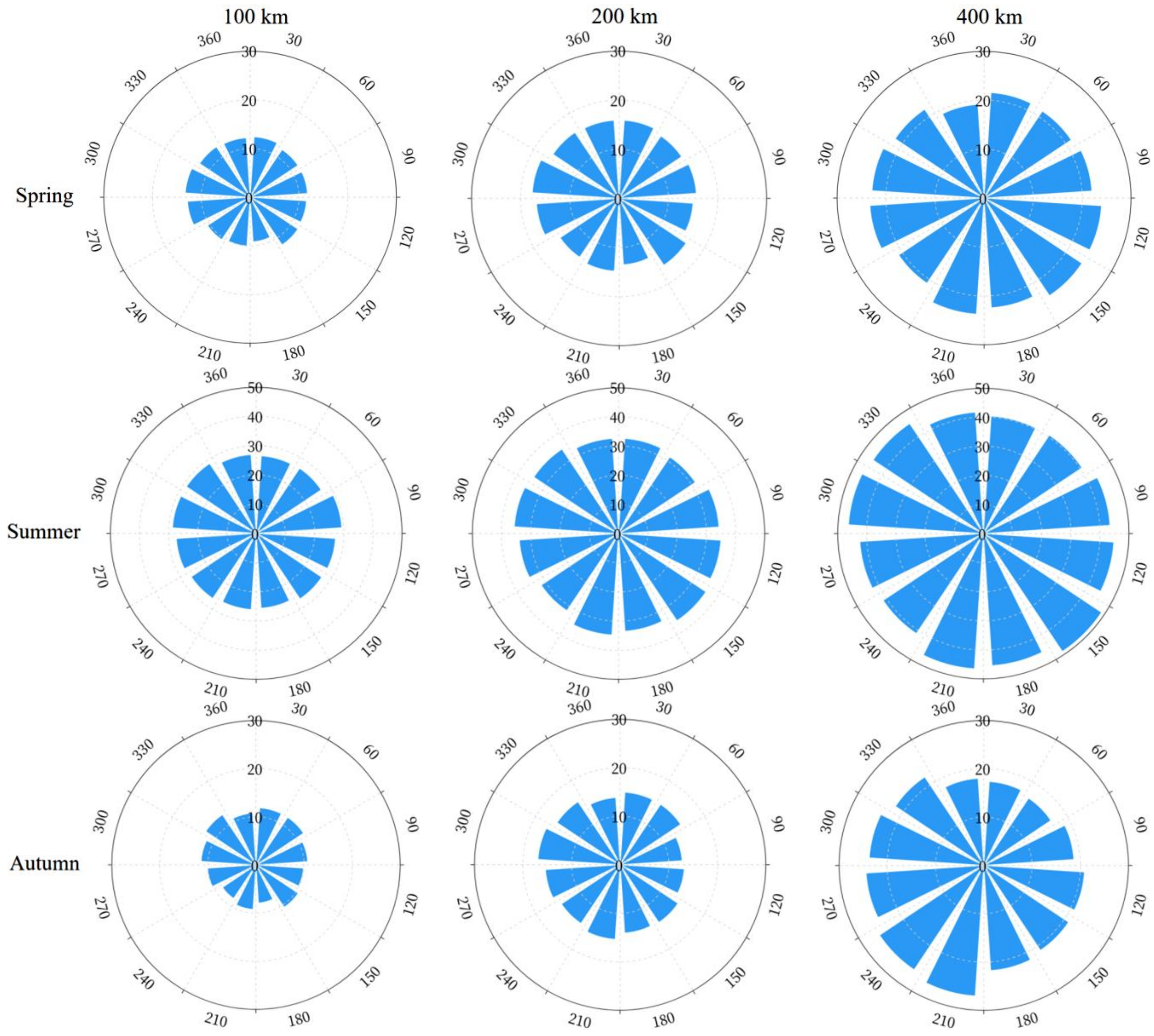
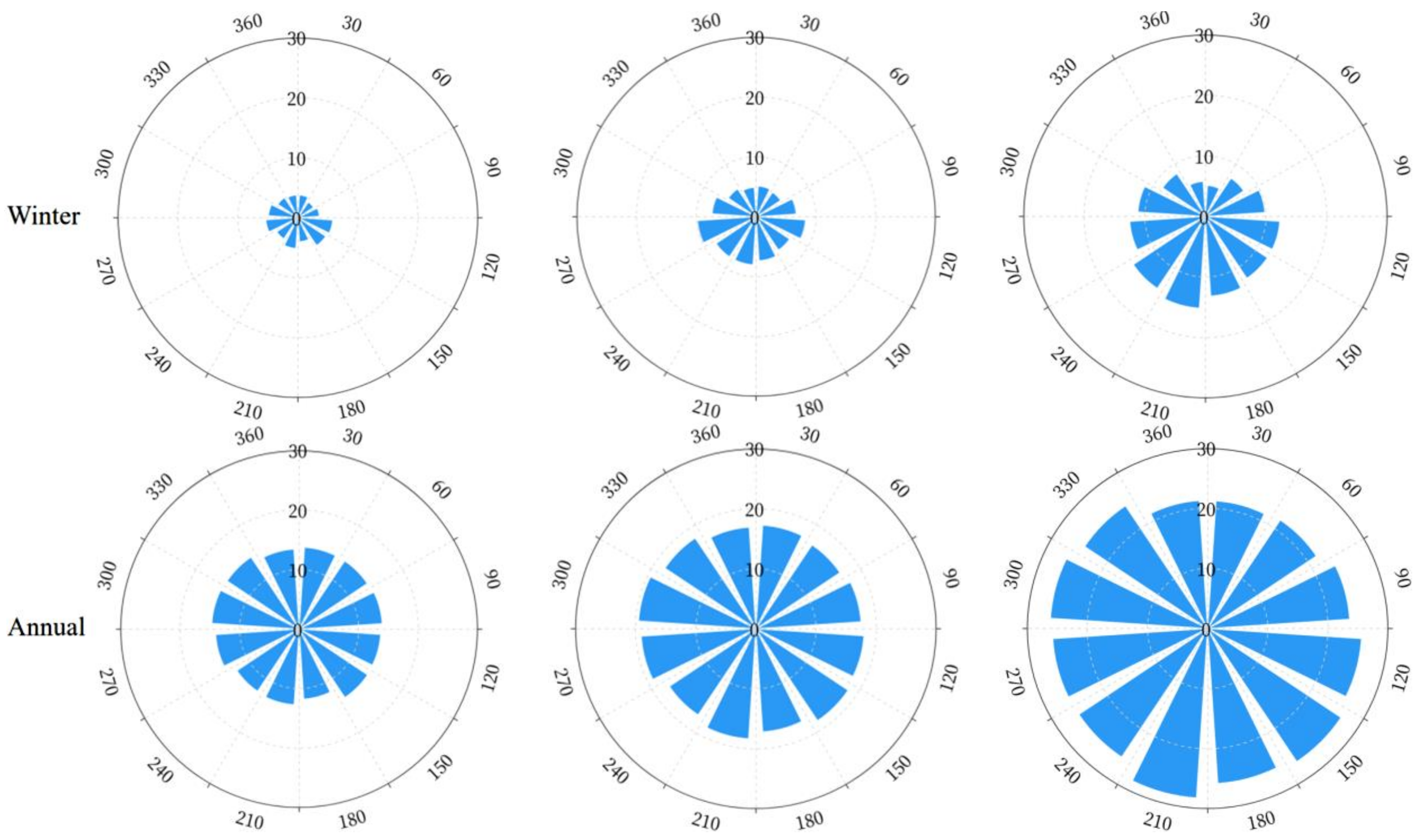
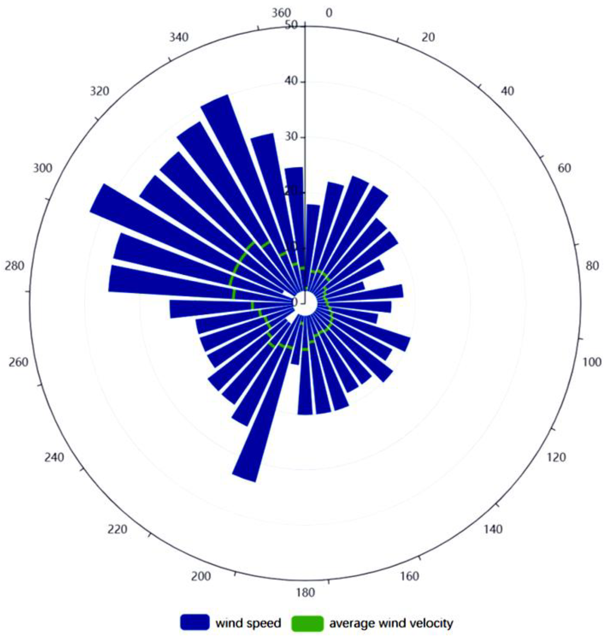
As shown in Figure 4, the COPs increase following distance annually and for four seasons in all directions. The highest COP occurred in summer and the lowest in winter. Among the 12 directions, the COPs in southwesterly directions (180°, 210°, and 240°) are 0.67–3.12% more than northeasterly directions (360°, 30°, and 60°). According to the wind detection data for every hour at the meteorological monitoring point of BCIA (http://data.cma.cn/, accessed on 3 January 2022), during 2016–2019, the most dominant category (20.85%) was non-directional, followed by the northerly wind (19.01%), as shown in Figure 5. The maximum average wind speed angle was in the direction of 320º, and the maximum average wind speed was 14.40 m/s. The instantaneous maximum wind speed was in the direction of 300°. More cloud was distributed in the south and southwest, as shown in Figure 4. In Figure 5, the wind speed in the north is higher than in the south, which is consistent with the prevailing northwestern monsoon in Beijing, especially in winter.

3.2. Haiyang Aerostat Production Base at Different Heights and Directions of COP

The settings for calculating the COP in Haiyang (121.22° E, 36.71° N) are: (1) the times are 02:00 UTC and 06:00 UTC during 2016–2020, (2) the flight heights are 6 and 9 km, and (3) the directions are toward the ocean (121.22° E, 35.71° N) and land (121.22° E, 37.71° N), with the test coverage distance fixed at 100 km.

3.2.1. COP at 6 km

In the direction of the ocean and land, during 2016–2020, annually and for four seasons, the resulting COPs for the flight height of 6 km are summarized in Table 4.
As shown in Table 4, during 2016–2020, at 02:00 UTC (ocean), the highest COP occurred in summer (28.04%), whereas the lowest COP occurred in winter (9.15%). The COP in spring was 15.47%, and in autumn was 17.58%. During 2016–2020, at 06:00 UTC (ocean), the highest COP occurred in summer (24.84%), whereas the lowest COP occurred in winter (10.74%). The COP in spring was 18.38%, and in autumn was 18.28%. During 2016–2020 (ocean), the COP in the morning was 17.60%. The COP in the afternoon was 18.09%, which was 0.49% higher than the COP in the morning.
During 2016–2020, at 02:00 UTC (land), the COP was lower than the COP in the direction of the ocean. The lowest COP occurred in winter (7.59%). The COP in spring was 12.2%, and in autumn was 13.41%. During 2016–2020, at 06:00 UTC (land), the highest COP occurred in summer (29.63%), whereas the lowest COP occurred in winter (10.29%).

3.2.2. COP at 9 km

In the direction of the ocean and land, during 2016–2020, annually and for four seasons, the resulting COPs for the flight height of 9 km are summarized in Table 5.
As shown in Table 5, during 2016–2020, at 02:00 UTC (ocean), the highest COP occurred in summer (16.52%), whereas the lowest COP occurred in winter (0.89%). The COP in spring was 5.45%, and in autumn was 4.84%, which was lower than spring. During 2016–2020, at 06:00 UTC (ocean), the highest COP occurred in summer (17.27%), whereas the lowest COP occurred in winter (2.24%). The COP in spring was 7.88%, and in autumn was 5.95%.
During 2016–2020, at 02:00 UTC (land), the highest COP occurred in summer (17.61%), whereas the lowest COP occurred in winter (0.89%). The COP in spring was 3.70%, and in autumn was 3.30%. During 2016–2020, at 06:00 UTC (land), the highest COP occurred in summer (19.17%), whereas the lowest COP occurred in winter (1.57%).
From Table 4 and 5, in the four seasons, no matter whether the morning or afternoon, the COP was the highest in summer and the lowest in winter. In winter, the air is dry, and there is almost no water vapor, resulting in limited cloud formation in winter. In summer, the temperature is high, and the evaporation of water vapor leads to increased air humidity. Clouds are formed when the water vapor rises to the upper air, so the COP in summer is higher than in other seasons. The COP in the morning in the land direction was lower than that in the afternoon. The main reason is that, after water evaporation, the water vapor concentration in the air is higher in the afternoon, so there are more clouds in the afternoon. With an increase in height, the COP gradually decreases.
In general, the COP for several seasons in the ocean direction is higher than in the land direction. For the aerostat flight test, the experiment can be conducted in the morning of winter and in the direction of land. Human eyes and optical cameras are less occluded by clouds, which can be used for inspection and monitoring. The calculation of COP is of guiding significance for the choice of flight test time and direction of aircraft.

3.3. Mount Qomolangma at Different Times of COP

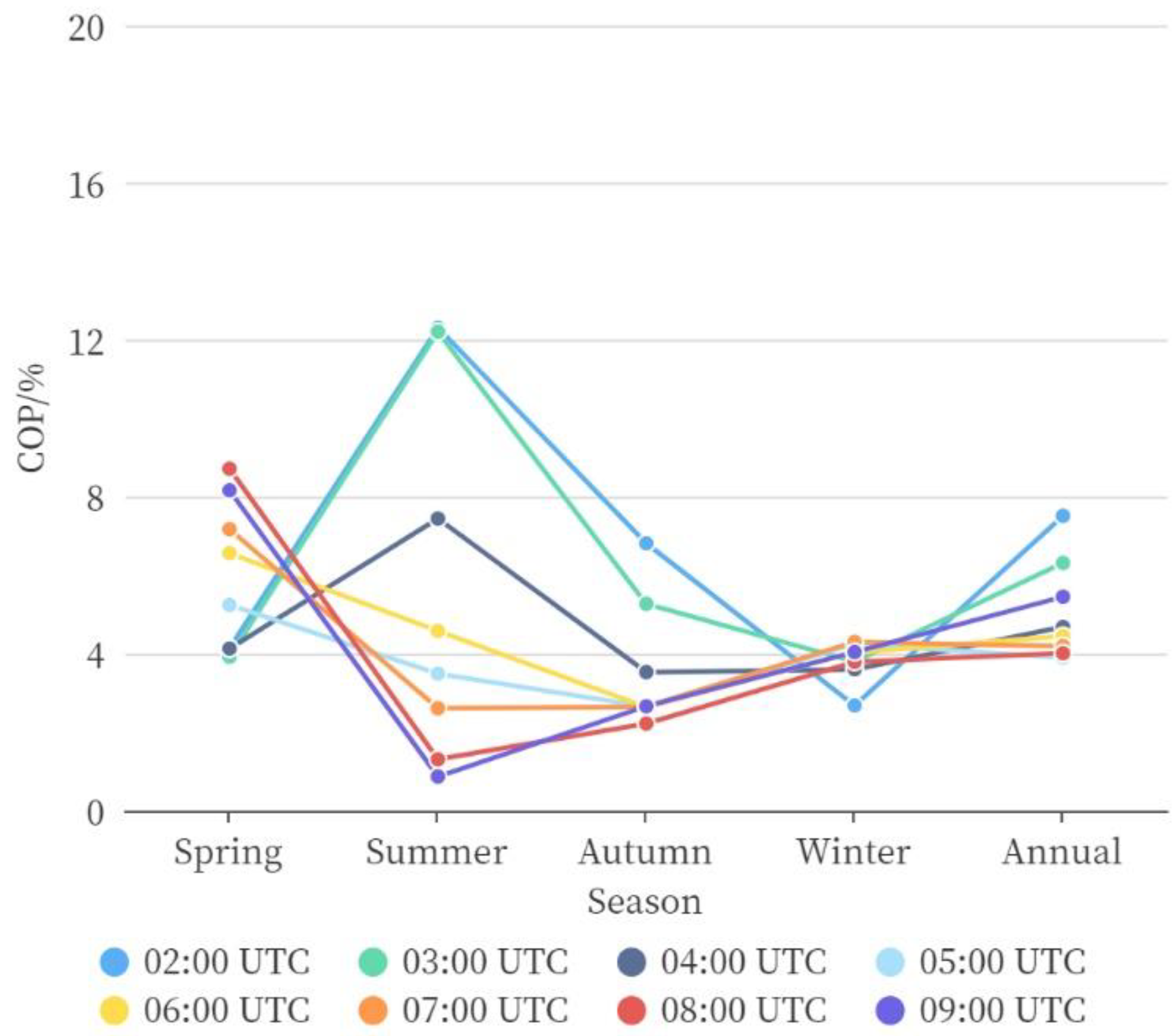
The settings for calculating the COP in Mount Qomolangma are: (1) the time is every hour between 02:00 and 09:00 UTC during 2016–2020, (2) the flight height is 9 km, and (3) the distance from start point (86.85° E, 28.14° N) to end point (86.36° E, 27.34° N) is 100 km. The annual and four seasons COP results are shown in Figure 6.
In spring, the COPs at 02:00 UTC–05:00 UTC were lower than at 06:00 UTC–09:00 UTC. However, it is the opposite in summer. The COP at 02:00 UTC was higher than at other times in summer and autumn, but lower than other times in spring and winter. Although the COP is generally low on Mount Qomolangma over the four seasons, considering the climatic environment of Mount Qomolangma, scientific observation was selected from 02:00 UTC–05:00 UTC in spring. This result coincides with the second scientific investigation (the afternoon of 15 May 2022) conducted by AIRCAS.

4. Conclusions

The method of obtaining COP was constructed only using satellite observations. It was applied by analyzing the COP in 12 directions from BCIA, the COP at different heights and directions at the AIRCAS Haiyang aerostat production base, and at different times and seasons in Mount Qomolangma. The COPs observed by satellite data can be summarized as follows: (1) During 2016–2020, the COP in the southern direction from BCIA was greater than that in the northern direction. (2) In Haiyang, the COP for several seasons in the land direction is lower than the ocean direction. The aerostat flight test can be conducted in the morning of winter and in the direction of land. (3) The best scientific observation time for Mount Qomolangma is between 02:00 and 05:00 UTC in spring.
This study provides a cloud occlusion calculation method only using satellite data for flight planning. The calculation of COP is of guiding significance for the planning of the flight time and route of aircraft. It can only solve the problem of visible occlusion but cannot solve the problem of meteorological disasters based on clouds. Currently, satellite observation can obtain sufficient horizontal distribution information of the cloud, but studies of vertical profiles are still limited to the cases of highly developed cumulonimbus clouds [33]. Since the vertical profile measurements are sparse, they only cover the sub-satellite point of orbit. The system currently cannot simulate cloud distribution in all scenarios, full-time series, and three-dimensional features, which would benefit the instantaneous cloud occlusion calculation. With the support of cloud data at different locations and different times, they can enable the dynamic analysis of the entire route of a specific flight plan. With the help of more data research, it will be possible to achieve single-flight cloud environment simulation.

Author Contributions

Conceptualization, H.D. and X.C.; methodology, H.D., X.C. and L.Z.; software, H.D., X.C., J.L. (Jiaguo Li) and L.Z.; validation, S.L., F.Z. and Z.L.; formal analysis, L.Z., S.L. and D.W.; investigation, X.C., J.L. (Jun Liu) and C.C.; resources, L.Z. and S.L.; data curation, L.Z. and D.W.; writing—original draft preparation, H.D. and X.C.; writing—review and editing, H.D. and X.C.; visualization, Z.L. and D.W.; supervision, L.Z. and C.C. All authors have read and agreed to the published version of the manuscript.

Funding

This research was funded by the National Natural Science Foundation of China (Grant No. 42171342) and the National Key Research and Development Program of China (Grant No. 2020YFE0200700 and 2019YFE0126600).

Institutional Review Board Statement

Not applicable.

Informed Consent Statement

Not applicable.

Data Availability Statement

Data used in the reported studies were obtained from websites, as indicated in the text.

Acknowledgments

The authors acknowledge the JAXA’s “P-Tree” system team and the NASA CloudSat Data Processing Center (DPC) team of the Cooperative Institute for Research in the Atmosphere (CIRA), Colorado State University.

Conflicts of Interest

The authors declare no conflict of interest. The funders had no role in the design of the study; in the collection, analyses, or interpretation of data; in the writing of the manuscript, or in the decision to publish the results.

References

  1. Wang, Y.; Liu, D.; Xie, W.; Yang, M.; Gao, Z.; Ling, X.; Huang, Y.; Li, C.; Liu, Y.; Xia, Y. Day and Night Clouds Detection Using a Thermal-Infrared All-Sky-View Camera. Remote Sens. 2021, 13, 1852. [Google Scholar] [CrossRef]
  2. Stephens, G.L. Cloud Feedbacks in the Climate System: A Critical Review. J. Clim. 2005, 18, 237–273. [Google Scholar] [CrossRef] [Green Version]
  3. Roscow, W.B.; Schiffer, R.A. Advances in understanding clouds from ISCCP. Bull. Am. Meteorol. Soc. 1999, 80, 2261–2287. [Google Scholar] [CrossRef]
  4. Xu, G.; Zhang, W.; Wan, X.; Wang, B. Cloud occurrence frequency and cloud liquid water path for non-precipitating clouds using ground-based measurements over central Chin. J. Atmos. Sol. Terr. Phys. 2021, 215, 105575. [Google Scholar] [CrossRef]
  5. Temme, M.M.; Tienes, C. Factors for Pilot’s Decision Making Process to Avoid Severe Weather during Enroute and Approach. In Proceedings of the 37th Digital Systems Avionics Conference (DASC), London, UK, 25–27 September 2018; pp. 1–10. [Google Scholar]
  6. Appleman, H.S. A Comparison of Simultaneous Aircraft and Surface Cloud Observations. J. Appl. Meteorol. 2010, 1, 548–551. [Google Scholar] [CrossRef]
  7. Lund, I.A. Estimating the Probability of Clear Lines-of-Sight from Sunshine and Cloud Cover Observations. J. Appl. Meteorol. Clim. 2010, 4, 714–722. [Google Scholar] [CrossRef]
  8. Lund, I.A.; Shanklin, M.D. Universal Methods for Estimating Probabilities of Cloud-Free Lines-of-Sight Through the Atmosphere. J. Appl. Meteorol. Clim. 1973, 12, 28–35. [Google Scholar] [CrossRef]
  9. Rapp, R.; Schutz, C.; Rodriguez, E. Cloud-Free Line-of-Sight calculations. J. Appl. Meteorol. 1973, 12, 484–493. [Google Scholar] [CrossRef]
  10. Luo, Y.; Zhang, R.; Wang, H. Comparing occurrences and vertical structures of hydrometeors between eastern China and the Indian monsoon region using CloudSat CALIPSO data. J. Clim. 2009, 22, 1052–1064. [Google Scholar] [CrossRef]
  11. Kato, S.; Sun-Mack, S.; Miller, W.F.; Rose, F.G.; Chen, Y.; Minnis, P.; Wielicki, B.A. Relationships among cloud occurrence frequency, overlap, and effective thickness derived from CALIPSO and CloudSat merged cloud vertical profiles. J. Geophys. Res. 2010, 115, D00H28. [Google Scholar] [CrossRef]
  12. Ruthrich, F.; Thies, B.; Reudenbach, C.; Bendix, J. Cloud detection and analysis on the Tibetan Plateau using Meteosat and Cloudsat. J. Geophys. Res. Atmos. 2013, 118, 10082–10099. [Google Scholar] [CrossRef]
  13. Tan, Z.; Ma, S.; Zhao, X.; Yan, W.; Lu, W. Evaluation of Cloud Top Height Retrievals from China’s Next-Generation Geostationary Meteorological Satellite FY-4A. J. Meteorol. Res. 2019, 33, 10. [Google Scholar] [CrossRef]
  14. Huang, Y.; Siems, S.; Manton, M.; Protat, A.; Majewski, L.; Nguyen, H. Evaluating Himawari-8 Cloud Products Using Shipborne and CALIPSO Observations: Cloud-top Height and Cloud-top Temperature. J. Atmos. Ocean. Technol. 2019, 36, 2327. [Google Scholar] [CrossRef] [Green Version]
  15. Yang, J.-H.; Yoo, J.-M.; Choi, Y.-S. Advanced Dual-Satellite Method for Detection of Low Stratus and Fog near Japan at Dawn from FY-4A and Himawari-8. Remote Sens. 2021, 13, 1042. [Google Scholar] [CrossRef]
  16. Sasidharan, A.; Ratna, K.V.; Venkata, R.M.O. Aerodynamic characteristics of an aerostat under unsteady wind gust conditions. Aerosp. Sci. Technol. 2021, 113, 106684. [Google Scholar]
  17. Zhang, Y.; Li, Z.; Bai, K.; Wei, Y.; Xie, Y.; Zhang, Y.; Ou, Y.; Cohen, J.; Zhang, Y.; Peng, Z.; et al. Satellite remote sensing of atmospheric particulate matter mass concentration: Advances, challenges, and perspectives. Fundam. Res. 2021, 1, 240–258. [Google Scholar] [CrossRef]
  18. Da, C. Preliminary assessment of the Advanced Himawari Imager (AHI) measurement onboard Himawari-8 geostationary satellite. Remote Sens. Lett. 2015, 6, 637–646. [Google Scholar] [CrossRef]
  19. Wang, Y.; Min, J.; Chen, Y.; Huang, X.; Zeng, M.; Li, X. Improving precipitation forecast with hybrid 3DVar and time-lagged ensembles in a heavy rainfall event. Atmos. Res. 2017, 183, 1–16. [Google Scholar] [CrossRef]
  20. Bessho, K.; Date, K.; Hayashi, M.; Ikeda, A.; Imai, T.; Inoue, H.; Kumagai, Y.; Miyakawa, T.; Murata, H.; Ohno, T.; et al. An Introduction to Himawari-8/9—Japan’s New-Generation Geostationary Meteorological Satellites. J. Meteorol. Soc. Jpn. 2016, 94, 151–183. [Google Scholar] [CrossRef] [Green Version]
  21. Chen, T.; Li, Z.; Kahn, R.A.; Zhao, C.; Rosenfeld, D.; Guo, J.; Han, W.; Chen, D. Potential impact of aerosols on convective clouds revealed by Himawari-8 observations over different terrain types in eastern China. Atmos. Chem. Phys. 2021, 21, 6199–6220. [Google Scholar] [CrossRef]
  22. Liu, B.; Huo, J.; Daren, L.Y.U.; Wang, X. Assessment of FY-4A and Himawari-8 cloud top height retrieval through comparison with ground-based millimeter radar at sites in Tibet and Beijing. Adv. Atmos. Sci. 2021, 38, 17. [Google Scholar] [CrossRef]
  23. She, L.; Zhang, H.K.; Li, Z.; de Leeuw, G.; Huang, B. Himawari-8 Aerosol Optical Depth (AOD) Retrieval Using a Deep Neural Network Trained Using AERONET Observations. Remote Sens. 2020, 12, 4125. [Google Scholar] [CrossRef]
  24. Ahmad, U.A.; Suherman, A.L.; Virgono, A.; Dirgantoro, B.; Septiawan, R.R.; Harjupa, W.; Utama, D.Q.; Risyanto, R.; Abadi, P.; Virgono, A.; et al. Verification of Himawari-8 Observation Data using Cloud Optical Thickness (COT) and Cloud Image Energy. Int. J. Adv. Comput. Sci. Appl. 2020, 11, 245–249. [Google Scholar] [CrossRef]
  25. Stephens, G.L.; Vane, D.G.; Tanelli, S.; Im, E.; Durden, S.; Rokey, M.; Reinke, D.; Partain, P.; Mace, G.G.; Austin, R.; et al. CloudSat mission: Performance and early science after the first year of operation. J. Geophys. Res. Atmos. 2008, 113, D00A18. [Google Scholar] [CrossRef]
  26. Hamann, U.; Walther, A.; Baum, B.; Bennartz, R.; Bugliaro, L.; Derrien, M.; Francis, P.N.; Heidinger, A.; Joro, S.; Kniffka, A.; et al. Remote sensing of cloud top pressure/height from SEVIRI: Analysis of ten current retrieval algorithms. Atmos. Meas. Tech. 2014, 7, 2839–2867. [Google Scholar] [CrossRef] [Green Version]
  27. Kodamana, R.; Fletcher, C.G. Validation of CloudSat-CPR Derived Precipitation Occurrence and Phase Estimates Across Canada. Atmosphere 2021, 12, 295. [Google Scholar] [CrossRef]
  28. Hung, M.-P.; Chen, W.-T.; Wu, C.-M.; Chen, P.-J.; Feng, P.-N. Intraseasonal Vertical Cloud Regimes Based on CloudSat Observations over the Tropics. Remote Sens. 2020, 12, 2273. [Google Scholar] [CrossRef]
  29. Naud, C.M.; Posselt, D.J.; Van, d.H.S.C. A CloudSat-CALIPSO View of Cloud and Precipitation Properties across Cold Fronts over the Global Oceans. J. Clim. 2015, 28, 6743–6761. [Google Scholar] [CrossRef]
  30. Christensen, M.; Stephens, G.; Lebsock, M. Exposing biases in retrieved low cloud properties from CloudSat: A guide for evaluating observations and climate data. J. Geophys. Res. Atmos. 2013, 118, 120–131. [Google Scholar] [CrossRef]
  31. Liu, C.-Y.; Chiu, C.-H.; Lin, P.-H.; Min, M. Comparison of cloud-top property retrievals from Advanced Himawari Imager, MODIS, CloudSat/CPR, CALIPSO/CALIOP, and radiosonde. J. Geophys. Res. Atmos. 2020, 125, e2020JD032683. [Google Scholar] [CrossRef]
  32. Ma, Y.; Ma, W.; Dai, H.; Zhang, L.; Sun, F.; Zhang, J.; Yao, N.; He, J.; Bai, Z.; Xuan, Y.; et al. Earth summit mission 2022–Scientific expedition and research on Mt. Qomolangma helps reveal the synergy between westerly winds and monsoon and the resulting climatic and environmental effects. Adv. Atmos. Sci. 2022. [CrossRef]
  33. Kim, M.; Im, J.; Park, H.; Park, S.; Lee, M.-I.; Ahn, M.-H. Detection of Tropical Overshooting Cloud Tops Using Himawari-8 Imagery. Remote Sens. 2017, 9, 685. [Google Scholar] [CrossRef]
Figure 1. Flowchart of the method of calculating COP using Himawari-8 and CloudSat data.
Atmosphere 13 01754 g001
Figure 2. BCIA cloud vertical distribution probability annually and for four seasons. From left to right: Annual, Spring (MAM), Summer (JJA), Autumn (SON), Winter (DJF).
Atmosphere 13 01754 g002
Figure 3. BCIA 12 directions at every 30° interval and the three distances of 100, 200, and 400 km from BCIA (enlarged view). In total, 36 routes were used to calculate COPs. The location of Haiyang (121.22° E, 36.71° N) (triangle) and Mount Qomolangma base camp (86.85° E, 28.14° N) (cross) are shown in the figure.
Atmosphere 13 01754 g003
Figure 4. The COPs in 12 directions from BCIA annually and for four seasons. The flight distances are 100, 200, and 400 km for the left, middle, and right columns, respectively (the circumferential axis is the clockwise direction angle from north as zero, and the radial axis is the COP with the unit %). The radial axis in summer is 50, and for the other seasons is 30.
Atmosphere 13 01754 g004aAtmosphere 13 01754 g004b
Figure 5. The distribution of wind speed at each angle of the BCIA meteorological monitoring points from 2016 to 2019 (the circumferential axis is the direction angle, and the radial axis is the wind speed, plotted in units of m s−1).
Atmosphere 13 01754 g005
Figure 6. The COPs of Mount Qomolangma at 02:00 UTC–09:00 UTC for four seasons and annually.
Atmosphere 13 01754 g006
Table 1. Spectral Bands of Himawari-8/AHI.
BandCentral Wavelength (μm)Spatial Resolution (km)
10.471
20.511
30.640.5
40.861
51.62
62.32
73.92
86.22
96.92
107.32
118.62
129.62
1310.42
1411.22
1512.42
1613.32
Table 2. CTH Statistics of Instrument Differences.
SatelliteBias (km)Standard Deviation (km)
Himawari-8−0.492.16
CloudSat−1.963.82
Table 3. Parameter Source.
ParameterSatellite
COTiHimawari-8
CTHHimawari-8
LCODx(j)CloudSat
CODxCloudSat
Table 4. The COPs of Haiyang (direction of the ocean and land) at 6 km (during 2016–2020, a total of 1827 days).
SeasonTime (UTC)DirectionObservation DaysCloud Occlusion DaysCOP
Spring02:00ocean4597115.47%
Summer02:00ocean46012928.04%
Autumn02:00ocean4558017.58%
Winter02:00ocean448419.15%
- Annual02:00ocean182432117.60%
Spring06:00ocean4578418.38%
Summer06:00ocean45911424.84%
Autumn06:00ocean4548318.28%
Winter06:00ocean4474810.74%
- Annual06:00ocean181932918.09%
Spring02:00land4595612.2%
Summer02:00land46012727.61%
Autumn02:00land4556113.41%
Winter02:00land448347.59%
- Annual02:00land182427815.24%
Spring06:00land4577616.63%
Summer06:00land45913629.63%
Autumn06:00land4548117.84%
Winter06:00land4474610.29%
- Annual06:00land181933918.64%
Table 5. The COPs of Haiyang (direction of the ocean and land) at 9 km (during 2016–2020, a total of 1827 days).
SeasonTime (UTC)DirectionObservation DaysCloud Occlusion DaysCOP
Spring02:00ocean459255.45%
Summer02:00ocean4607616.52%
Autumn02:00ocean455224.84%
Winter02:00ocean44840.89%
- Annual02:00ocean18241276.96%
Spring06:00ocean457367.88%
Summer06:00ocean4597917.21%
Autumn06:00ocean454275.95%
Winter06:00ocean447102.24%
- Annual06:00ocean18191528.36%
Spring02:00land459173.70%
Summer02:00land4608117.61%
Autumn02:00land455153.30%
Winter02:00land44840.89%
- Annual02:00land18241176.41%
Spring06:00land457275.91%
Summer06:00land4598819.17%
Autumn06:00land454224.85%
Winter06:00land44771.57%
- Annual06:00land18191447.92%
Publisher’s Note: MDPI stays neutral with regard to jurisdictional claims in published maps and institutional affiliations.