Highlights
What are the main findings?
- The Haishao-1 satellite, operating at an orbital altitude below 350 km, successfully achieved 1-m high-resolution imaging in Stripmap mode, demonstrating the superior imaging capability of VLEO-SAR systems.
- Analysis of system parameters and imaging results confirms that VLEO-SAR enables higher azimuth resolution with a smaller antenna aperture while maintaining a high signal-to-noise ratio.
What are the implications of the main findings?
- The findings validate the potential of VLEO-SAR for designing lower-cost, high-performance payloads, which can significantly reduce satellite development and launch expenses.
- VLEO-SAR platforms offer enhanced suitability for large-scale constellation deployment, enabling shorter revisit intervals and supporting critical applications such as real-time disaster monitoring and military reconnaissance.
Abstract
Very-Low Earth Orbit Synthetic Aperture Radar (VLEO SAR) satellites, defined as SAR satellites operating at orbital altitudes 350 km or below, offer distinct technical advantages compared to conventional SAR satellites. Equipped with a high-resolution SAR payload, the Haishao-1 (HS-1) satellite was successfully launched on 4 December 2024. According to publicly available information, the HS-1 satellite represents the world’s first VLEO SAR satellite and has successfully demonstrated 1-m resolution Stripmap mode imaging with continuous azimuth coverage. Through an analysis of the HS-1 satellite’s system parameters and imaging results, this paper comprehensively explores the advantages of VLEO SAR satellites over traditional orbit SAR satellites, particularly in terms of enhanced resolution, reduced payload costs, and improved constellation deployment capabilities. VLEO SAR satellites possess significant advantages, including the potential for higher-resolution imagery and lower-cost payload designs, positioning them for extensive application prospects in fields such as space-based military reconnaissance, natural resource surveying, and natural disaster monitoring.
1. Introduction
Synthetic Aperture Radar (SAR) is a remote sensing technology that probes the Earth’s surface using microwave signals [,,,]. Unlike optical remote sensing, SAR actively transmits radar signals and receives backscattered echoes. This enables it to penetrate cloud cover and precipitation for surface observation, providing all-day and all-weather imaging capabilities. Deploying SAR on satellites facilitates global high-resolution imaging, making it widely applicable in Earth observation domains such as topographic mapping [], agricultural monitoring [], forest resource inventory, ocean surveillance [], and disaster early warning []. Consequently, spaceborne SAR has increasingly become a focal research area in Earth observation.
Conventional spaceborne SAR systems are predominantly deployed at higher orbits (typically above 500 km) [,,,]. While these SAR satellites provide relatively high-resolution imagery, their greater distance from the Earth’s surface often necessitates a trade-off between image resolution and signal-to-noise ratio (SNR). For instance, a smaller antenna aperture generally results in reduced SNR, whereas an enlarged antenna aperture leads to degraded azimuth resolution and concurrently increases satellite volume and launch costs.
Very-Low Earth Orbit (VLEO) SAR satellites, typically defined as SAR satellites operating at orbital altitudes below 350 km, possess distinct advantages compared to conventional SAR satellites deployed at higher orbital altitudes [,,]. First, the significantly reduced distance to the Earth’s surface enables VLEO SAR satellites to achieve higher azimuth resolution with a smaller antenna aperture, while maintaining a high SNR in the imagery. Second, the lower orbital altitude translates to relatively lower launch costs. Furthermore, the reduced satellite size and mass make VLEO SAR platforms significantly more suitable for large-scale deployment and constellation formation. A VLEO SAR constellation offers a substantially shorter revisit interval, facilitating more frequent Earth observations. This capability is particularly crucial for emergency response and real-time monitoring applications. Consequently, VLEO SAR satellites are recognized as a pivotal future direction in remote sensing technology, demonstrating immense application potential in areas demanding high-precision ground imaging, disaster early warning, and emergency response.
This paper aims to analyze the technical advantages of VLEO SAR satellites. Using the HS-1 satellite as a case study, it examines in detail its high-resolution imaging capabilities. The paper is structured as follows: Section 2 introduces the basic specifications and key technical parameters of the SAR payload onboard the HS-1 satellite. Section 3 analyzes the advantages of VLEO SAR satellites in achieving high azimuth resolution, using HS-1’s imaging results as demonstrative examples. Section 4 discusses the benefits of VLEO spaceborne SAR concerning payload development and constellation deployment. Section 5 provides the concluding remarks, summarizing the unique advantages of VLEO spaceborne SAR and outlining its future development trends.
2. Technical Specifications of the Haishao-1 Satellite
The Haishao-1 (HS-1) satellite is a novel remote sensing platform featuring a hybrid optical-SAR system. It was successfully launched from the Xichang Satellite Launch Center, China, on 4 December 2024. The satellite operates at an orbital inclination of 43° with a nominal orbital altitude of 350 km, and possesses orbital maneuverability.
The HS-1 SAR payload operates in the X-band, delivering high-resolution imagery, wide swath coverage, and multi-polarimetric imaging capabilities (including single-, dual-, and compact polarimetry). This enables all-weather and day-and-night precise observation of the Earth’s surface. To comprehensively address diverse user requirements, HS-1 supports multiple operational modes. Conventional modes include Stripmap mode, Sliding Spotlight mode, and ScanSAR mode.
Experimental modes encompass High-Resolution Spotlight mode, Video SAR mode, and Squint mode. Additionally, HS-1 is equipped with a all-time low-light optical camera, facilitating integrated optics-SAR synergistic observation. The primary imaging modes are summarized in Table 1.

Table 1.
SAR working mode of HS-1.
The ground resolution achievable across these modes ranges from 0.5 m to 20 m, corresponding to swath widths from 8 km to 160 km, highlighting substantial variations in performance. Leveraging the satellite platform’s agility, the SAR system can perform wide-area azimuth scanning, achieving extended azimuth observation coverage. The azimuth resolution is superior to 0.3 m. The payload also incorporates range scanning capability, enabling a swath width of up to 160 km in ScanSAR mode.
The system block diagram of the HS-1 SAR payload is illustrated in Figure 1. The payload primarily comprises a phased array antenna and a highly integrated SAR electronics subsystem. The SAR antenna employs a planar solid-state active phased array with two-dimensional scanning capability. It operates with dual-polarization (Horizontal (H) and Vertical (V)). The design and development of the SAR payload system incorporated advanced system integration and lightweighting techniques. This approach resulted in a total SAR payload mass of less than 80 kg.
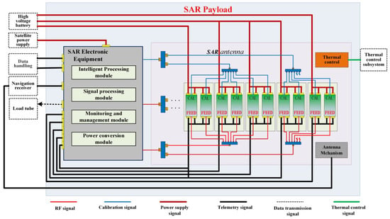
Figure 1.
The SAR payload system block diagram of the HS-1.
3. Analysis of High-Resolution Advantages in VLEO SAR Satellites
As a VLEO SAR satellite, HS-1 has a core advantage in its capability to achieve high-resolution (1-m) continuous observation in the azimuth direction.
The satellite operates in a side-looking stripmap mode. The antenna azimuth dimension is , the wavelength of the transmitted signal is , the satellite inertial velocity is , and the beam velocity on the ground is . The 3 dB beamwidth of the radar is given by:
The azimuth bandwidth of a target corresponds to the frequency variation during the illumination time. Thus, the Doppler bandwidth is:
Through azimuth matched filtering, the azimuth resolution is:
where is the broadening factor introduced during processing. For the HS-1 satellite, the SAR antenna azimuth dimension is 2 m, the wavelength is 0.03125 m, the satellite inertial velocity is 7695.46 m/s, and the ground beam velocity is 7294.72 m/s. The azimuth broadening factor is approximately 1.2. Additionally, the antenna design achieves a beam broadening of 1.2 times in the azimuth direction. Consequently, the azimuth resolution of the HS-1 SAR in stripmap mode can be expressed:
The stripmap mode imaging results of HS-1 are presented in Figure 2, with the corresponding acquisition parameters provided in Table 2. Two prominent point targets are identifiable within the scene. Their Interpolated result and two-dimensional intensity profiles are displayed in Figure 3, and the extracted performance parameters for these targets are summarized in Table 3. Analysis reveals that the achieved azimuth resolution and the ground range resolution of the HS-1 SAR payload in stripmap mode are both superior to 1 m.
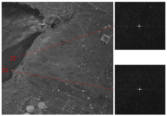
Figure 2.
Stripmap mode image of the calibration field, acquired by HS-1.

Table 2.
Stripmap Mode Imaging Parameters.
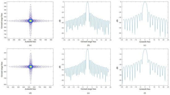
Figure 3.
The azimuth and range profile of the strong scatter point: (a) Interpolated result for the strong scatter point 1; (b) Range profile for the point 1; (c) Azimuth profile for the point 1; (d) Interpolated result for the strong scatter point 2; (e) Range profile for the point 2; (f) Azimuth profile for the point 2.

Table 3.
Stripmap Mode Image Quality Metrics of HS-1.
This long-range, high-resolution, seamless continuous observation capability establishes a critical foundation for meeting the surveillance requirements of specific targets. For targets with significant linear and continuous characteristics and variable orientations, such as coastline [,], seismic belt [,], railways [], roads [], power transmission lines, and rivers, efficient surveillance necessitates that the orientation of the imaging swath tightly conforms to the target’s actual extended path, rather than being constrained by the satellite’s flight direction (i.e., enabling non-alone-track imaging []).
Conventional imaging approaches often struggle to simultaneously achieve long-range continuous coverage and swath orientation flexibility when pursuing high resolution. The innovation of HS-1 resides in its powerful high-resolution continuous azimuth observation capability, combined with range scanning, enabling high-resolution non-alone-track imaging. The resulting application advantage is revolutionary. For extensive road networks or power transmission grids spanning hundreds of kilometers, VLEO SAR can utilize this high-resolution non-alone-track imaging mode to generate a continuous, seamless, ultra-long strip image within a single pass, with its direction highly consistent with the target’s orientation and a resolution as high as 1 m. This not only avoids the timeliness lag associated with traditional multi-pass image mosaicking but, more importantly, the 1-m resolution is sufficient to clearly capture the key features of the target. This seamless, high-resolution, directionally adaptive surveillance capability can significantly enhance the efficiency, coverage, and granularity of infrastructure monitoring, demonstrating the irreplaceable value of VLEO SAR in areas vital to national infrastructure and public welfare, such as road inspection and power grid safety monitoring.
Figure 4 and Figure 5 respectively show the 1-m resolution non-alone-track imaging results of the HS-1 satellite for targets including power transmission lines and the Yangtze River. Furthermore, leveraging azimuth beam steering, HS-1 attained 0.5-m resolution in Sliding Spotlight mode; an example Sliding Spotlight image is presented in Figure 6. The following is an analysis of how VLEO SAR satellites, represented by HS-1, achieve high-resolution imaging advantages.
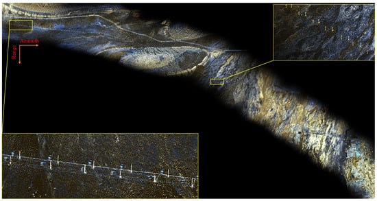
Figure 4.
Non-alone-track mode image of Xinjiang, China, acquired by HS-1. The achieved resolution of 1 m with an NESZ of −18 dB.
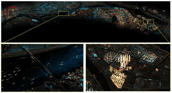
Figure 5.
Non-alone-track mode image of the Nanjing section of the Yangtze River, acquired by HS-1. The achieved resolution is 1 m with an NESZ of −19 dB.
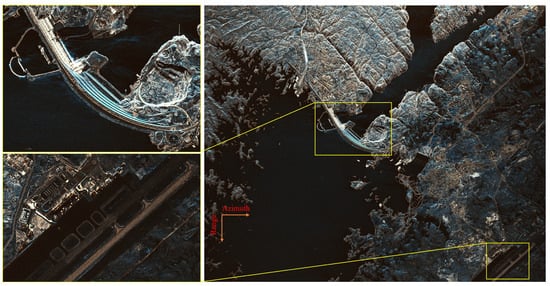
Figure 6.
Sliding Spotlight mode image of the Aswan Dam, Egypt, acquired by HS-1. The achieved resolution is 0.5 m and an NESZ of −17 dB.
In Stripmap mode, the azimuth resolution of a spaceborne SAR system is approximately half the length of the azimuth antenna aperture []. Consequently, reducing the azimuth antenna aperture enhances azimuth resolution. Furthermore, to achieve wide-swath imaging in the range dimension, the elevation antenna height can be reduced to form a wider beam, enabling broader coverage. However, antenna dimensions cannot be minimized indefinitely. To meet specific performance requirements, a SAR antenna possesses a fundamental minimum size constraint. Operating below this minimum antenna area threshold renders the SAR system incapable of proper functionality.
To ensure the reception of all signals across the imaging swath within a single Pulse Repetition Interval (PRI), the constraint on the range antenna dimension is derived as follows [,]:
where denotes the transmitted signal wavelength, denotes the incidence angle at the far edge of the imaging swath, c denotes the speed of light, denotes the Pulse Repetition Frequency, and denotes the slant range to the far edge of the imaging swath, which can be expressed as:
where H is the satellite orbital altitude, is the earth’s radius, and is the look angle at the far edge of the imaging swath.
The azimuth sampling theorem restriction imposes another constraint on the azimuth dimension of the antenna:
where, is the antenna azimuth dimension; is the flight speed of the satellite. In summary, the minimum antenna area in SAR operating regime can be obtained as follows:
Assuming that the SAR operates in the X-band with a carrier frequency of 9.6 GHz and a far-end incidence angle of 45°, the relationship between the minimum area and the orbital altitude is shown in Figure 7.
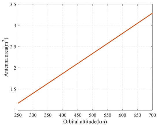
Figure 7.
Relationship between minimum antenna area and orbital altitude.
As evident from the Figure 7, the minimum antenna area increases with increasing orbital altitude. SAR satellites operating in the VLEO require a significantly smaller antenna area for proper functionality compared to conventional LEO SAR satellites. Consequently, VLEO SAR satellites can more readily employ a reduced azimuth antenna length, thereby enabling the achievement of higher azimuth resolution.
Beyond resolution, the Noise Equivalent Sigma Zero (NESZ) represents another critical performance metric in SAR imaging that requires careful consideration []. The NESZ of SAR can be expressed as:
where R represents the distance between the radar and the target, is the noise figure of the system, k denotes the Boltzmann constant, with a value of J/K, denotes the temperature of the system, represents system loss, B denotes system bandwidth, denotes average transmit power, and represent the transmit and receive gains of the antenna, respectively, is the wavelength, c is the speed of light, denotes the incident angle, and V denotes the speed of the radar.
The antenna gain can be expressed as follows:
where A is the antenna effective aperture area.
In (11), the first product term consists of constant coefficients and invariant radar system parameters, which remain unchanged with variations in orbital altitude. If the satellite’s orbital altitude changes, both the slant range and the satellite velocity will also change. To maintain a constant NESZ level, the required antenna area must correspondingly satisfy:
where and represent the slant range and satellite velocity after the orbital altitude changes, respectively; , , and denote the antenna effective aperture area, bandwidth, and average transmit power that satisfy the requirement of maintaining a constant NESZ after the orbital change.
For a phased array antenna, the peak transmit power is defined as the product of the transmit power per individual transmit/receive (T/R) channel and the total number of such channels. The average transmit power, in turn, is given by the product of this peak power and the system duty cycle. Assuming two SAR systems employ identical T/R channel technology, the transmit power per channel and the duty cycle can be considered equivalent.
Performance metrics related to range and azimuth ambiguity are directly influenced by the antenna pattern. To maintain consistent antenna scanning capability across SAR systems operating at different orbital altitudes, a fixed spacing between T/R channels is necessary. This design constraint implies that the total number of T/R channels is proportional to the physical aperture area of the antenna. It follows that the average transmit power is proportional to the antenna area. Furthermore, the requirement for an identical range resolution dictates the use of the same signal bandwidth across systems.
These conditions lead to the relation:
from which it follows that
Simplification of this expression yields the final result
Figure 8 illustrates the antenna area required for SAR satellites at different orbital altitudes to maintain the same NESZ performance level, assuming a maximum incidence angle of 45°.
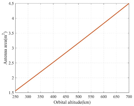
Figure 8.
Minimum Antenna Area Required at Different Orbital Altitudes for Identical NESZ.
As evident from Figure 8, maintaining identical imaging performance metrics necessitates an antenna area of approximately 3.5 m2 for a SAR satellite at a 550 km orbital altitude, while a satellite at 300 km altitude requires only about 1.8 m2. Reducing the incidence angle requirement to 40° further decreases the required antenna area at 300 km altitude to approximately 1.6 m2.
Consider representative existing X-band SAR satellites: TerraSAR-X features an antenna size of 4.8 m × 0.8 m and operates at an altitude of 514.8 km; Hongtu-1 features an antenna size of 3.6 m × 0.768 m and operates at an altitude of 528 km. Their primary operational modes are listed in Table 4 as detailed previously.

Table 4.
Comparison of Imaging Modes Across Different SAR Satellites.
As evidenced by the Table 4, the HS-1 satellite leverages its VLEO characteristics to demonstrate unique advantages in high-resolution imaging. SAR satellites operating at altitudes above 500 km generally require relatively large antenna areas to achieve satisfactory performance metrics. This larger antenna area necessitates a correspondingly significant azimuth dimension, making achieving high azimuth resolution particularly challenging. For reference, the TerraSAR-X satellite, with an azimuth dimension of approximately 4.8 m, achieves a resolution of about 3 m in Stripmap mode.
While Spotlight imaging can be employed to attain higher azimuth resolution, this mode is inherently constrained by its beam steering design. Spotlight mode cannot achieve continuous azimuth observation, and its azimuth swath width is significantly limited. Taking TerraSAR-X as an example, owing to its azimuth beam steering capability of only ±0.75°, the achievable azimuth swath width is restricted to approximately 5 km.
In contrast, the HS-1 satellite, operating at a 350 km orbital altitude, utilizes an azimuth antenna dimension of merely 2 m. Through azimuth beam broadening, it achieves an azimuth resolution superior to 1 m in Stripmap mode. This accomplishment represents the first instance globally of a spaceborne SAR system achieving continuous observation with 1-m resolution in Stripmap mode.
In summary, conventional SAR satellites at higher orbital altitudes typically employ large antenna apertures to enhance the NESZ. According to the fundamental relationship between azimuth resolution and antenna azimuth dimension in Stripmap mode, it is exceptionally difficult for SAR satellites above 500 km altitude to achieve 1-m azimuth resolution in Stripmap mode. The low orbital altitude of VLEO satellites reduces signal path loss, enabling the maintenance of an SNR even with a smaller antenna aperture, while simultaneously achieving high azimuth resolution. Consequently, VLEO SAR satellites possess distinct advantages in realizing high-resolution imaging capabilities.
4. Analysis of System Advantages for VLEO SAR Satellites
VLEO SAR satellites, operating at significantly reduced orbital altitudes, demonstrate substantial advantages in radar system design, energy efficiency, and engineering costs. A comparative analysis of technical parameters from representative satellites, TerraSAR-X [] (conventional orbit), Hongtu-1 [] (conventional orbit), and HS-1 (VLEO), provides a clear illustration of the impact of orbital altitude on system performance and cost.
The reduced orbital altitude directly minimizes radar antenna area requirements. As established by the derived formula and supporting figure, antenna size exhibits a positive correlation with orbital altitude under constant NESZ performance. For instance, the HS-1 satellite, operating at 350 km, achieves an approximate 58% reduction in antenna area compared to TerraSAR-X at 514 km. This design optimization significantly reduces the consumption of high-cost composite materials for the antenna substrate and decreases the number of T/R modules along with associated circuit complexity, substantially lowering antenna development and manufacturing costs []. Concurrently, the reduced antenna area simplifies phased array calibration procedures and shortens system testing and debugging cycles, effectively controlling research and development expenditures.
Furthermore, the VLEO regime significantly reduces electromagnetic wave path loss. This enables the radar system to maintain identical NESZ performance with lower transmit power. Engineering validation indicates that HS-1’s antenna power requirement is nearly 50% lower than comparable X-band satellites in conventional orbits. This reduced power demand yields cascading benefits: operational stress on critical components such as Power Amplifiers is reduced, extending their lifespan and lessening reliance on higher-grade, more expensive components, thereby lowering electronic system costs []. Additionally, the power subsystem design can be simplified, allowing for smaller solar arrays [] and battery banks, which alleviates load demands on the satellite platform.
Synergistic platform and launch cost optimizations represent another key economic benefit of the VLEO design. Orbital mechanics dictate that achieving a lower target orbit requires less propellant for orbital insertion. The combined mass reduction stemming from the lightweight antenna and downsized power subsystem permits a lighter structural bus and smaller attitude control thrusters, enabling the satellite to utilize a smaller, standardized bus platform. This overall miniaturization facilitates deployment using lower-cost commercial launch vehicles. Moreover, the potential for batch production further amortizes research and development expenditures, creating a pronounced economic advantage.
Critically, the lower development and launch costs inherent to VLEO SAR satellites make large-scale deployment and constellation formation highly feasible. A constellation of multiple VLEO SAR satellites can provide high-revisit-rate, persistent monitoring of specific areas, achieving rapid ground target revisit times. This capability delivers timelier data support essential for applications demanding rapid response, such as emergency management and disaster monitoring.
5. VLEO Challenges and Mission Design Countermeasures
As analyzed in the previous section, SAR satellites operating in a VLEO benefit from significant advantages, including enhanced spatial resolution and reductions in platform, payload, and launch costs. However, this orbital regime also presents significant challenges. The primary difficulties are accelerated orbital decay and degraded attitude stability due to increased atmospheric drag, as well as inherent constraints on data downlink capacity imposed by the shorter orbital period. This section provides a systematic analysis of these challenges and details the specific engineering countermeasures implemented in the HS-1 mission to ensure its operational success.
The most prominent challenge in VLEO is the accelerated orbital decay induced by increased atmospheric drag. To maintain its designated operational orbit against this persistent deceleration, HS-1 employs a hybrid propulsion system. This system integrates a high-efficiency Krypton Hall thruster, with a total impulse of 53 kNs, and a chemical propulsion system, with a total impulse of 32.5 kNs. This combined capability is designed to provide continuous drag compensation and execute larger orbit adjustments as needed, enabling the satellite to achieve its planned three-year mission lifetime under anticipated atmospheric density variations, modeled with a satellite drag coefficient of 2.2.
Beyond orbital decay, the variable atmospheric drag at VLEO altitudes induces substantial disturbance torques, which challenge the precise attitude control mandatory for high-quality SAR imaging. To mitigate this, HS-1 is equipped with Control Moment Gyroscopes (CMGs). Compared to conventional reaction wheels, CMGs provide superior torque authority and control agility, effectively countering the rapid fluctuations in aerodynamic forces. This ensures the stringent pointing stability and maneuverability required for advanced SAR imaging modes, such as the Video SAR mode.
The operation of HS-1 in the demanding VLEO environment serves as a valuable pathfinder for researching next-generation technologies. Promising avenues for further development, which are critical for the sustainability of future VLEO missions, include the exploration of specialized drag-reduction satellite configurations and the advancement of autonomous orbit-keeping and mission planning algorithms. The in-orbit data and operational experience gathered from HS-1 will be instrumental in validating and advancing these technologies.
6. Conclusions
This paper has presented the technical and systemic advantages of VLEO SAR satellites, highlighting their unique strengths in high-resolution imaging, low-cost deployment, and constellation formation. The case study of the -1 satellite has demonstrated the substantial potential of VLEO SAR technology across diverse application domains. Looking ahead, the launch of additional VLEO SAR satellites and the maturation of dedicated constellations are anticipated to enable these systems to play an increasingly critical role in global-scale real-time monitoring, disaster early warning, and environmental protection.
With advancing technology, the resolution and imaging capabilities of VLEO SAR satellites will be further enhanced. It is anticipated that within the coming years, VLEO SAR technology will emerge as a significant trend within the remote sensing field, providing global applications with more precise and frequent Earth surface observation data.
Author Contributions
Conceptualization, S.Y.; methodology, S.Y.; software, S.Y.; validation, S.Y.; formal analysis, S.Y.; investigation, S.Y. and J.S.; resources, J.S.; writing-original draft preparation, S.Y.; writing-review and editing, S.Y., S.C., S.W., W.S. and H.L.; visualization, S.Y.; supervision, J.S.; project administration, J.S.; funding acquisition, H.L. All authors have read and agreed to the published version of the manuscript.
Funding
This research was funded by Shandong Provincial Natural Science Foundation of China under grant number ZR2022QF119.
Data Availability Statement
The data presented in this study are available on request from the corresponding author.
Conflicts of Interest
The authors declare no conflict of interest.
References
- Moreira, A.; Prats-Iraola, P.; Younis, M.; Krieger, G.; Hajnsek, I.; Papathanassiou, K.P. A tutorial on synthetic aperture radar. IEEE Geosci. Remote Sens. Mag. 2013, 1, 6–43. [Google Scholar] [CrossRef]
- Ouchi, K. Recent Trend and Advance of Synthetic Aperture Radar with Selected Topics. Remote Sens. 2013, 5, 716–807. [Google Scholar] [CrossRef]
- Mason, D.C.; Speck, R.; Devereux, B.; Schumann, G.J.P.; Neal, J.C.; Bates, P.D. Flood Detection in Urban Areas Using TerraSAR-X. IEEE Trans. Geosci. Remote Sens. 2010, 48, 882–894. [Google Scholar] [CrossRef]
- Xue, F.; Lv, X.; Dou, F.; Yun, Y. A Review of Time-Series Interferometric SAR Techniques: A Tutorial for Surface Deformation Analysis. IEEE Geosci. Remote Sens. Mag. 2020, 8, 22–42. [Google Scholar] [CrossRef]
- Li, X.; Lv, X.; Huang, Z. Underlying Topography Estimation over Forest Using Maximum a Posteriori Inversion with Spaceborne Polarimetric SAR Interferometry. Remote Sens. 2024, 16, 948. [Google Scholar] [CrossRef]
- Jafarzadeh, H.; Verma, A.; Mahdianpari, M.; Bhattacharya, A.; Homayouni, S. Enhanced Crop Discrimination and Monitoring Using Compact-Polarimetric SAR Signature Analysis from RADARSAT Constellation Mission. IEEE J. Sel. Top. Appl. Earth Obs. Remote Sens. 2024, 17, 6308–6327. [Google Scholar] [CrossRef]
- Zhang, K.; Hu, Y.; Yang, J.; Wang, X. Sea Surface Wind Speed Retrieval Using Gaofen-3-02 SAR Full Polarization Data. Remote Sens. 2025, 17, 591. [Google Scholar] [CrossRef]
- Milillo, P.; Fielding, E.J.; Shulz, W.H.; Delbridge, B.; Burgmann, R. COSMO-SkyMed Spotlight Interferometry Over Rural Areas: The Slumgullion Landslide in Colorado, USA. IEEE J. Sel. Top. Appl. Earth Obs. Remote Sens. 2014, 7, 2919–2926. [Google Scholar] [CrossRef]
- Geudtner, D.; Torres, R.; Snoeij, P.; Davidson, M.; Rommen, B. Sentinel-1 System capabilities and applications. In Proceedings of the 2014 IEEE Geoscience and Remote Sensing Symposium, Quebec City, QC, Canada, 13–18 July 2014; pp. 1457–1460. [Google Scholar] [CrossRef]
- Werninghaus, R.; Buckreuss, S. The TerraSAR-X Mission and System Design. IEEE Trans. Geosci. Remote Sens. 2010, 48, 606–614. [Google Scholar] [CrossRef]
- Sun, J.; Yu, W.; Deng, Y. The SAR Payload Design and Performance for the GF-3 Mission. Sensors 2017, 17, 2419. [Google Scholar] [CrossRef] [PubMed]
- Wang, R.; Liu, K.; Cai, Y.; Liang, D.; Yu, W.; Liu, D.; Chen, Y.; Yang, Q.; Li, J.; Liu, L. LuTan-1: An Innovative L-band Spaceborne Bistatic Interferometric SAR Mission. In Proceedings of the EUSAR 2024—15th European Conference on Synthetic Aperture Radar, Munich, Germany, 23–26 April 2024; pp. 984–988. [Google Scholar]
- Chen, G.; Wu, S.; Deng, Y.; Jiao, J.; Zhang, Q. VLEO Satellite Constellation Design for Regional Aviation and Marine Coverage. IEEE Trans. Netw. Sci. Eng. 2024, 11, 1188–1201. [Google Scholar] [CrossRef]
- Dakka, S.M. VLEO satellites—A new earth observation space systems commercial and business model. In Proceedings of the 36th International Communications Satellite Systems Conference (ICSSC 2018), Niagara Falls, ON, Canada, 15–18 October 2018; pp. 1–11. [Google Scholar] [CrossRef]
- Gomez, Y.M. Optimization Approach for a SAR small satellite in Very Low Earth Orbit (VLEO) Demonstrator Mission. In Proceedings of the 2024 IEEE Aerospace Conference, Big Sky, MT, USA, 2–9 March 2024; pp. 1–9. [Google Scholar] [CrossRef]
- Eugenio, F.; Marcello, J.; Martin, J. High-Resolution Maps of Bathymetry and Benthic Habitats in Shallow-Water Environments Using Multispectral Remote Sensing Imagery. IEEE Trans. Geosci. Remote Sens. 2015, 53, 3539–3549. [Google Scholar] [CrossRef]
- Wu, X.; Liu, C.; Wu, G. Spatial-Temporal Analysis and Stability Investigation of Coastline Changes: A Case Study in Shenzhen, China. IEEE J. Sel. Top. Appl. Earth Obs. Remote Sens. 2018, 11, 45–56. [Google Scholar] [CrossRef]
- Chen, N.; Ni, N.; Kapp, P.; Chen, J.; Xiao, A.; Li, H. Structural Analysis of the Hero Range in the Qaidam Basin, Northwestern China, Using Integrated UAV, Terrestrial LiDAR, Landsat 8, and 3-D Seismic Data. IEEE J. Sel. Top. Appl. Earth Obs. Remote Sens. 2015, 8, 4581–4591. [Google Scholar] [CrossRef]
- Wang, X.; Dou, A.; Ding, X.; Yuan, X. The Development of Rapid Extraction and Publishing System of Earthquake Damage Based on Remote Sensing. In Proceedings of the IGARSS 2018—2018 IEEE International Geoscience and Remote Sensing Symposium, Valencia, Spain, 22–27 July 2018; pp. 2921–2924. [Google Scholar] [CrossRef]
- Qin, X.; Liao, M.; Zhang, L.; Yang, M. Structural Health and Stability Assessment of High-Speed Railways via Thermal Dilation Mapping With Time-Series InSAR Analysis. IEEE J. Sel. Top. Appl. Earth Obs. Remote Sens. 2017, 10, 2999–3010. [Google Scholar] [CrossRef]
- Babu, A.; Baumgartner, S.V. Road Surface Quality Assessment Using Polarimetric Airborne SAR. In Proceedings of the 2020 IEEE Radar Conference (RadarConf20), Florence, Italy, 21–25 September 2020; pp. 1–5. [Google Scholar] [CrossRef]
- Wang, Y.; Kang, L.; Liu, J. Spaceborne SAR non-along-track imaging mode: Opportunities and challenges. J. Radars 2022, 11, 1131–1145. [Google Scholar]
- Li, J.; Chen, J.; Wang, P.; Loffeld, O. A Coarse-to-Fine Autofocus Approach for Very High-Resolution Airborne Stripmap SAR Imagery. IEEE Trans. Geosci. Remote Sens. 2018, 56, 3814–3829. [Google Scholar] [CrossRef]
- Tomiyasu, K. Tutorial review of synthetic-aperture radar (SAR) with applications to imaging of the ocean surface. Proc. IEEE 1978, 66, 563–583. [Google Scholar] [CrossRef]
- Suess, M.; Grafmueller, B.; Zahn, R. A novel high resolution, wide swath SAR system. IGARSS 2001. Scanning the Present and Resolving the Future. In Proceedings of the IEEE 2001 International Geoscience and Remote Sensing Symposium (Cat. No. 01CH37217), Sydney, Australia, 9–13 July 2001; Volume 3, pp. 1013–1015. [Google Scholar] [CrossRef]
- Shi, L.; Yang, L.; Zhao, L.; Li, P.; Yang, J.; Zhang, L. NESZ Estimation and Calibration for Gaofen-3 Polarimetric Products by the Minimum Noise Envelope Estimator. IEEE Trans. Geosci. Remote Sens. 2021, 59, 7517–7534. [Google Scholar] [CrossRef]
- Deng, Y.; Zhang, H.; Liu, K.; Wang, W.; Ou, N.; Han, H.; Yang, R.; Ren, J.; Wang, J.; Ren, X.; et al. Hongtu-1: The First Spaceborne Single-Pass Multibaseline SAR Interferometry Mission. IEEE Trans. Geosci. Remote Sens. 2025, 63, 5202518. [Google Scholar] [CrossRef]
- Stangl, M.; Werninghaus, R.; Zahn, R. The TERRASAR-X active phased array antenna. In Proceedings of the IEEE International Symposium on Phased Array Systems and Technology, Boston, MA, USA, 14–17 October 2003; pp. 70–75. [Google Scholar] [CrossRef]
- Shin, D.H.; Yom, I.B.; Kim, D.W. X-band GaN MMIC power amplifier for the SSPA of a SAR system. In Proceedings of the 2017 IEEE International Symposium on Radio-Frequency Integration Technology (RFIT), Seoul, Republic of Korea, 30 August–1 September 2017; pp. 93–95. [Google Scholar] [CrossRef]
- Hengkang, Q.; Jifeng, H.; Xianhua, W.; Qianlin, Y.; Hong, C.; Baofa, S.; Lisheng, Z.; Kaijian, C. Overview of dual bus solar array design for SAR satellite. In Proceedings of the 2022 3rd China International SAR Symposium (CISS), Shanghai, China, 2–4 November 2022; pp. 1–5. [Google Scholar] [CrossRef]
Disclaimer/Publisher’s Note: The statements, opinions and data contained in all publications are solely those of the individual author(s) and contributor(s) and not of MDPI and/or the editor(s). MDPI and/or the editor(s) disclaim responsibility for any injury to people or property resulting from any ideas, methods, instructions or products referred to in the content. |
© 2025 by the authors. Licensee MDPI, Basel, Switzerland. This article is an open access article distributed under the terms and conditions of the Creative Commons Attribution (CC BY) license (https://creativecommons.org/licenses/by/4.0/).