Abstract
SfM (structure from motion) photogrammetry is a technique developed in the field of computer vision that enables the generation of three-dimensional (3D) models from a set of overlapping images captured from disparate angles. The application of this technique in the field of cultural heritage, particularly in the context of megalithic monuments, is inherently challenging due to the spatial constraints of these environments and the usual limitations posed by their architectural design, which often results in poor lighting conditions. This article presents an accurate and cost-efficient methodology for the study and documentation of rock art, which has been applied to three megalithic monuments in the Iberian Peninsula: one in Spain and two in Portugal. The three working environments are complex, but the combination of techniques used and improvements such as rendering for the enhancement of engravings and the creation of 3D stop-motion models made it possible to integrate all the information in 3D formats that allow its universal dissemination. This not only preserves the heritage in graphic form but also makes it accessible to the public, both for study and for virtual visits.
1. Introduction
The development of three-dimensional (3D) models has become a fundamental tool in the professional practice of archaeological heritage technicians, enabling them to improve the quality and efficiency of their projects. The utilisation of precise models facilitates comprehensive research across a range of disciplines. Art historians, for instance, can examine the evolution of architectural styles over time, analysing each component and structural modification with unprecedented accuracy [1]. Similarly, archaeologists can virtually reconstruct ancient structures, thereby facilitating a deeper understanding of past civilisations [2]. The dissemination of historical and architectural heritage also benefits significantly from digital documentation. Three-dimensional models enable the creation of interactive educational experiences that can be used in museum environments or mobile applications, allowing virtual exploration of the building or archaeological site [3,4]. The acquisition of geometric data represents a fundamental aspect of the process of digital heritage documentation, particularly in the modelling context. The traditional methodologies that were once the predominant approach in this field have been gradually replaced in recent decades. More recent techniques, such as terrestrial laser scanning (TLS) [5,6] and structure-from-motion (SfM) photogrammetry [7,8], have significantly impacted the way cultural heritage sites are represented. These methods offer high-resolution, 3D photorealistic records, which greatly exceed the capabilities of traditional approaches. They provide objectivity to scientific-technical studies, enhance the presentation of heritage to the public [9,10], and facilitate the collection of geometric data during heritage interventions in an accurate and non-invasive way [11].
The term “approach photogrammetry” is used to describe a technique for acquiring metric data of objects using ground photography. This method has a substantial lineage, which has experienced significant advances following the emergence of structure from motion (SfM) and multi-view stereo (MVS) methodologies. In contrast to traditional photogrammetry and early versions of short-range photogrammetry software, which restricted users to manipulating discrete points and basic surfaces, contemporary SfM-MVS photogrammetry software automates the generation of point clouds, triangular meshes, and textured 3D models for complex surfaces. The financial outlay required for photographic equipment and software is considerably less than that needed for 3D scanning, which has contributed to the substantial growth of SfM-MVS photogrammetry in the field of heritage modelling. Consequently, photogrammetry is experiencing an increase in utilisation among archaeologists, historians, and conservators [12,13,14,15,16,17,18].
Notwithstanding the advantages above, the utilisation of SfM techniques is constrained by several significant limitations at a considerable number of archaeological sites. For instance, the geometric intricacy of megalithic rock formations frequently imposes significant spatial constraints, thereby limiting the applicability of non-invasive techniques [12]. A further well-known issue is the absence or lack of indoor light, which makes it challenging to obtain geometric information with SfM [19]. The absence of natural light restricts the range of photographic parameters that can be employed, necessitating either an increase in sensitivity and, consequently, noise and pixel size, or an extension of the exposure time, which can result in blurred images or, in some cases, the use of tripods that impede the accurate imagery documentation.
The nature of colour information can also be affected by external factors, such as illumination or its digitalisation. Consequently, it is of particular importance to have a comprehensive understanding of the way operational conditions and applied procedures can influence it to ensure the creation of an accurate model [20].
For all these reasons, even though SfM photogrammetry is readily assimilated and demonstrates considerable technical adaptability, its application necessitates expertise in complex archaeological sites, such as megalithic monuments. Furthermore, this kind of cultural heritage frequently encompasses rock art specimens, both engraved and pictorial forms. The documentation of these requires high-resolution geometric [21] and radiometric [22] data. In such cases, SfM photogrammetry is particularly advantageous due to its non-invasive nature and the ability to utilise geometric or radiometric enhancements. These techniques facilitate the efficient documentation of intricate details in rock art samples that may otherwise be challenging to discern visually [23,24]. Indeed, a comprehensive representation of this type of heritage must involve the complete documentation of these elements, coupled with 3D modelling and geometric and radiometric enhancement in the processing of the acquired data. In light of the above considerations, the objective of this study is to present an effective and accurate methodology for the documentation and dissemination of megalithic monuments exhibiting intricate geometric forms, accompanied by rock art specimens such as engravings and paintings.
2. Materials and Methods
In the 3D modelling of all the archaeological sites, the material resources and methodology employed were identical. The following section will describe the hardware and software used, the techniques applied, and the subsequent results obtained. The camera network on which the SfM-MVS techniques were used was obtained with a Simple Digital Single-Lens Reflex (DSLR) camera, specifically an Olympus Pen EP-1™. The E-P1 is a compact mirrorless interchangeable lens camera that emulates the design of the company’s Pen range, which was popular in the 1960s and 1970s. The camera is constructed around an image-stabilised 12-megapixel Four Thirds sensor (17.3 × 13 mm) and incorporates a 3.0-inch LCD. A 14 mm fixed focal length lens, measured in 35 mm equivalent, was used. Despite its modest performance, the image quality is notably high compared to the most advanced APS-C models. The selection of a more contemporary camera with a full-frame sensor could have been made; however, the study was aimed to show that with traditional and cost-effective equipment, the advancement of the SfM-MVS software and a meticulous working procedure can yield high-quality results.
Agisoft Metashape™ 2.1.3 photogrammetric software (Agisoft LLC., St. Petersbug, Russia) was used to produce dense point clouds and 3D models. Although there are other products on the market with equivalent functionality, Metashape allows a higher degree of customisation of the work process and is the most affordable of all commercial products [25]. Metashape allows the creation of 3D models from the depth maps of the images, which is essential to obtain the best possible geometric definition and minimise noise. This feature is not available in other similar photogrammetric software solutions [26,27].
The workflow is divided into three stages: First, the internal and external orientation of the images is performed; in this phase, the position of each camera of the camera network and the scene geometry are reconstructed simultaneously by applying the automatic identification of matching features using the Scale Invariant Feature Transform (SIFT) [28,29]. This algorithm provides initial estimates of each camera’s position and object coordinates, which are then iteratively refined by non-linear least squares minimisation. The sparse bundle adjustment system “Bundler” [29] is used for this task. Secondly, an improved density point cloud and a 3D mesh of triangular elements can be obtained by applying the Clustering View for Multiview Stereo (CMVS) and Patch-based Multiview Stereo (PMVS2) algorithms [30,31]. Finally, it is possible to add texture to the mesh to obtain the final model, which can be retouched and improved using other software packages.
3. Results
This study involves three megalithic sites situated within the Iberian Peninsula, with one located in Spain and two in Portugal. Figure 1 illustrates the location of the aforementioned megalithic sites, as well as miniature representations of their models and the geographical coordinates of the archaeological remains of the Mosteirô necropolis. The monuments of Lapa da Moura or Chã dos Cabanos and Chã da Escusalha are situated in this area. Points 2 and 3 belong to the group of megalithic remains located on various platforms on the western slope of the Serra Amarela, within the municipality of Ponte da Barca in the district of Viana do Castelo in northwest Portugal. The Serra Amarela is found between the watersheds of the Lima and Cávado rivers, with its eastern border forming the international boundary between Portugal and Spain.
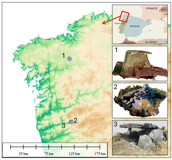
Figure 1.
Geographical location and images of the modelled megalithic monuments.
The sites were selected based on their geographical proximity, cultural significance, and distinctive topographical features, which present challenges in the conventional application of SfM-MVS techniques. The dolmen of Dombate (A Coruña, Spain) dates from the first half of the fourth millennium BC. It is one of the most representative sites of Iberian megalithic archaeology. In this monument, there are two superimposed burial mounds: the main one is 24 m in diameter and 1.80 m high. It consists of a layer of earth partially concealed by a stone cover. This consists of a wide polygonal chamber comprising seven orthostats of a maximum of 4.64 × 3 m and a corridor with three sections. Both the chamber and the corridor present important remains of art, such as engravings or paintings. This dolmen is classified as a collective corridor tomb and is considered the “cathedral of megalithism” in the northwest of Spain. The Megalithic Sites of Chã dos Cabanos and Chã da Escusalha (Portugal) were preliminarily presented in [32] along with other sites from the Mosteirô necropolis in the context of a multidisciplinary interpretative study, which is currently under development.
As the methodology was practically identical for all three sites, the first will be presented in detail, while only the results obtained for the other two will be shown. Table 1 provides a summary of the size of the camera networks of the three studies, together with the characteristics of each site and the presence or absence of pictorial remains or engravings.

Table 1.
Characteristics and images collected for each site.
3.1. 3D Modelling of Dombate Dolmen
A comprehensive photographic network comprising 990 images was employed to build the 3D model. This included 532 exterior photographs, 403 interior photographs, and 55 linking images. Figure 2 provides an opportunity to analyse the three types of photography. The upper part of the figure shows a view of the exterior elements (Figure 2A), while the lower part comprises four detailed photographs. In the upper left corner of Figure 2B, the external elements are depicted. In the upper right corner, Figure 2C presents a view of the upper part of the Dolmen. The lower section of the figure is comprised of Figure 2D, which illustrates a detail of the lower area, and Figure 2E, which depicts a linked photograph between the interior and exterior.
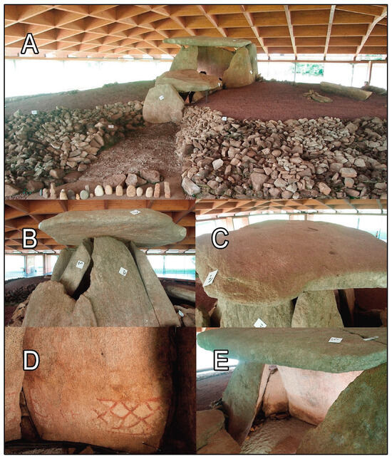
Figure 2.
(A) General View. (B) Exterior of the dolmen. (C) Top view. (D) Interior photos. (E) Linking between exterior and interior.
No tripods or camera stabilisation systems were employed for the recording of the entire camera network, even under poor lighting conditions. The simplicity and directness of this photographic method permitted the completion of the work within a brief period of time, which was of particular importance for the modelling of the interior of the burial chamber, access to which was limited to 20 min for reasons of conservation.
Insufficient illumination was a significant obstacle in the production of the 3D models. To address this, artificial light in the form of a flash was employed to illuminate the area to be recorded for each shot. During the interior photography session, particular attention was paid to accurately documenting the engravings in the corners, as well as the remainder of the engravings and paintings of the monument. It is common for some orthostats of dolmens to experience partial collapses, generally towards the interior of the chamber, creating gaps or recesses at the intersections of the orthostats. This results in parts of the original surfaces of the funerary chamber walls becoming partially or entirely concealed by the collapsed orthostat, forming areas more protected from deterioration. Studying these more sheltered spaces is especially important, not only because they often contain better-preserved carvings and paintings but also because they are less explored due to the difficulty accessing them. Methods such as laser scanning face greater challenges in achieving accurate recording in these contexts. The case study of Dombate exemplifies this situation, as numerous previous geometric records have not documented all the carvings present in these recesses. This situation is repeated in the other two case studies.
To obtain a model that is not only aesthetically pleasing but also accurately reflects the megalithic monument, it is essential to ensure that it is scaled and correctly oriented. To achieve this, targets of the kind illustrated in Figure 3 were employed. The purpose of these targets is to assist to orient the cameras, as Metashape can identify them automatically, thus accelerating the work process. The scaling was carried out using a bar scale, which enabled the correct dimensional adjustment to be achieved. To facilitate the work, a single scale was used, which was placed in various positions of the site (Dombate and Chã dos Cabanos) or in a single one but taking different measurements (Chã da Escuslha).
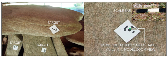
Figure 3.
Scaling and camera orientation elements.
Once the camera network is complete in the way described above, with the orientation and scaling elements, the SfM-SVM techniques can be applied, following the three-step workflow described in Section 2. The result will be a 3D and textured model. Figure 3 illustrates the orientation (targets) and scaling (scale bar) elements, showcasing the detail of one of the targets detected by the software. Figure 4 presents a global view of the model, wherein the photogrammetric overlay with the oriented cameras and the bundle adjustment can be observed.
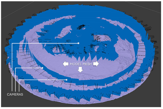
Figure 4.
Camera position and model mesh obtained after the second stage.
The final step in the workflow involves applying textures to the mesh through an automated process. This step focuses on generating image files to realistically colour the detailed mesh structure. As the study was conducted on historical sites where paintings and engravings are present, particular attention was devoted to enhancing their visibility. Ultimately, the model was endowed with distinctive aesthetic attributes by applying stop motion techniques.
The software packages employed in this phase of the study were Meshlab, Dstrech, and Sketcfab. Meshlab 2023.12 is free and an open-source software (FOSS), a licence for Dstrech can be obtained for $50, and Sketchfab is a free repository where 3D models can be uploaded and slightly enhanced for publication. Their main characteristics are the following:
MeshLab is an open-source software designed for the processing and editing of 3D triangular meshes. It provides a range of functionalities, including the following:
- The cleaning and repair of meshes: The software is capable of identifying and rectifying inconsistencies within the mesh, including the removal of holes, the consolidation of duplicated faces, and the resolution of non-manifold edges. These capabilities are of particular significance for downstream processing and visualisation.
- Mesh filtering and smoothing: MeshLab permits the selective filtering of noise or superfluous details while maintaining the overall structure. The application of smoothing functions can serve to enhance the visual quality of the reconstructed model.
- Texturing: MeshLab facilitates the implementation of texture mapping, which enables the application of chromatic data derived from photographic sources to the 3D model. This is of particular value in the highlighting of the appearance of reliefs and the visualisation of the remains of paintings.
DStretch is a program designed for the analysis and enhancement of digital rock art imagery. Although its principal function is in the field of archaeological investigation, it can also be a valuable component in the workflow for the reconstruction of megalithic monuments:
- Image manipulation and enhancement: The DStretch 8.41 software provides tools for contrast adjustments, colour balancing, and noise reduction, specifically designed to enhance the visibility of faint details within the captured imagery. This can be particularly useful for the revelation of subtle details in reliefs or remnants of paintings that may be obscured in unprocessed photographs.
- Digital tracing and interpretation: DStretch provides functionalities for tracing and outlining the features of interest within the images. This can be used to isolate and analyse specific elements of the reliefs or paintings, thus aiding in the interpretation of their significance.
Sketchfab is a web-based platform that enables the publication and sharing of 3D models online. It provides an accessible repository for the presentation of reconstructed megalithic monuments in a user-friendly format. Sketchfab was selected as the platform for disseminating the models following an analysis of the available alternatives. The creation of the software and its installation on a website [4] were rejected for two reasons: firstly, due to its complexity, and secondly, because of its lesser dissemination compared to the 3D model platform that is most widely used, even by museums that hold virtual exhibitions of their pieces [9].
Other possibilities might be Wikimedia Commons and WebGL-based platforms; the former does not currently satisfy the minimum requirements for the introduction of textured 3D models. A recent addition to the available file options is the STL format. However, this format only allows for the display of geometries without the option of including textures. Conversely, WebGL-based platforms do permit the presentation and redrawing of three-dimensional models; however, they possess several shortcomings that significantly complicate their utilisation. Such platforms necessitate a certain degree of programming expertise for model creation and are not inherently compatible with the typical export formats of both commercial and public-domain photogrammetry software. These shortcomings, coupled with the pervasive and direct utilisation of Sketchfab, which offers integrated visualisation capabilities, render its consideration beyond the purview of this article. Ultimately, the authors have identified only one free, open alternative, 3DHOOP (https://3dhop.net/howto.php, accessed on 3 September 2024), which offers a comprehensive gallery of 3D models of diverse objects. However, the relatively limited distribution of this platform suggests that Sketchfab may be the optimal choice, as it facilitates more extensive dissemination of the results. Some of Sketchfab’s main functions are the following:
- Interactive visualisation: Sketchfab permits users to interact with the 3D model by rotating, zooming, and panning, thereby facilitating a more comprehensive understanding of the monument’s structure and details.
- Accessibility and dissemination: By publishing the 3D models on Sketchfab, it is possible to make your reconstructions readily accessible to a wider audience, including researchers, educators, and the general public.
3.2. Model Enhancement
The subsequent processing of the data extracted from Metashape is also comprised of several phases. In the initial phase, the mesh generated by Metashape is imported into MeshLab. Meshlab software enables the user to work on a model extracted from the Metashape software, allowing for the refinement and improvement of its texture. Additionally, it facilitates the application of functions such as radiance scaling, which enhances the visibility of the engravings. To achieve enhanced visibility of the pictorial remains, DStretch was employed. Its radiometric functions facilitate the visualisation of paintings that would otherwise be inaccessible with the use of SfM-MVS techniques, despite the advanced nature of the software. Once the above processes have been completed, the models are made public using Sketchfab. The dissemination of the results with this platform also uses some of its visualisation options, which allow geometric enhancements to be obtained, finally achieving a photo-realistic and publicly accessible result.
3.2.1. Improved Visualisation of Engravings
Meshlab permits the execution of a multitude of functions, including the modification of illumination parameters. However, in the present case, it has not been employed to enhance the quality of the model that has already been refined with Metashape. Instead, the sole function utilized was “Radiance Scaling.” This rendering technique enables the depiction of shapes through shading, achieved through the modification of light intensities around specific features. The primary objective is to establish a correlation between shading and surface feature variations, thereby enhancing the visibility of shape details such as concavities and convexities. It was therefore employed solely to enhance the visibility of the engravings. Different values of the radiance scaling process were carefully tested until the best possible visualisation was achieved. The detailed MeshLab interface for rendering is presented in Figure 5, together with the effect produced on the engravings of the Dombate dolmen, depending on the selected options. The upper part of the figure displays the engravings, which were practically invisible before the utilisation of Meshlab. The lower part of the figure illustrates the Radiance Scaling filter interface, accompanied by the engravings, which are now clearly discernible. Figure 6 also shows significant improvement in the engravings compared to the initial visualization.
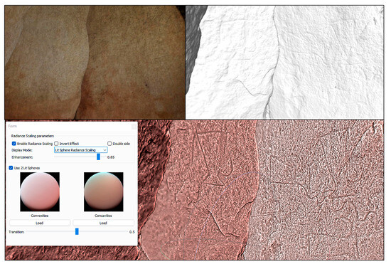
Figure 5.
On the top, view of the engravings before applying Meshlab Radiance Scaling. On the bottom left, engravings with much better visibility and the Meshlab interface for Radiance Scaling application.
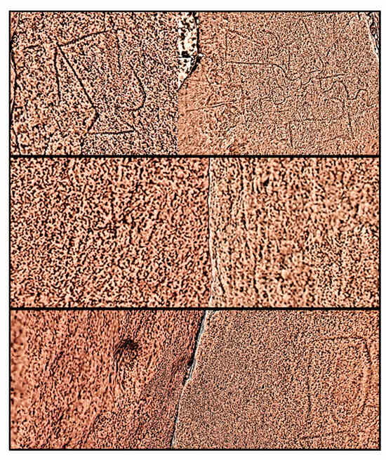
Figure 6.
Detail of Dombate dolmen engravings after Radiance Scaling Shader rendering application.
3.2.2. Enhancement of Pictorial Remains
Decorrelation is any process employed to reduce autocorrelation within a signal or cross-correlation within a set of signals without loss of information and while keeping its integrity. Its application, with varying approaches, in image processing is prevalent due to the strong correlation between the pixels of any image. The reduction of this correlation can facilitate compression or the removal of spatial redundancy between pixels, thereby enhancing the perception of details that were previously obscured by noise [33]. Because of the latter property, the colour decorrelation functions available in DStretch were used to improve the visibility of the paints. By using a similar methodology to that applied to the engravings, different decorrelation ratios were tested until the best possible view was obtained. Figure 7 shows the result after applying the software in the upper part and its graphical interface in the lower part.
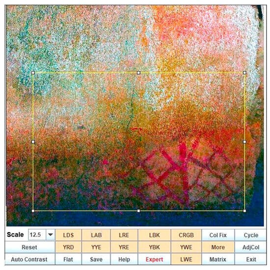
Figure 7.
DStretch interface for radiometric enhancement application.
3.3. Online Results Dissemination
A comprehensive survey and dissemination of the megalithic monuments were conducted, and the results were published on Sketchfab. This section will present some of the key features of this platform and provide details of the results obtained for the Dombate dolmen. It will conclude with links to the rest of the megalithic monuments. Firstly, the enhanced texture obtained for all the models will be presented in Figure 8. This will be followed by an examination of the properties of Sketchfab, which can also be applied during the visualisation process. Figure 9 illustrates the advanced configuration menu of the Sketchfab visualisation environment. It depicts the geometric enhancement rendering, Matcap, which must be activated within the tool “Model Inspector” to obtain the optimal visualisation of the engravings.
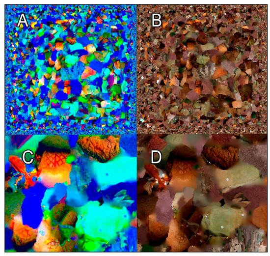
Figure 8.
(A) Enhanced texture. (B) Original texture. (C) Enlargement of the enhanced texture. (D) Enlargement of the original texture.
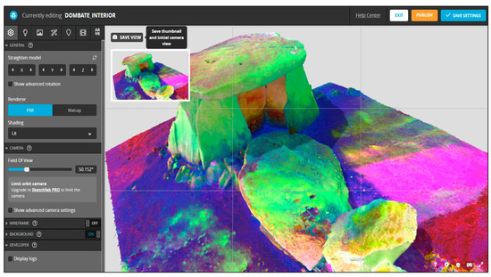
Figure 9.
Sketchfab 3D settings menu.
The outcomes of the documentation process are presented in the following section. The complete model of the Dombate dolmen, obtained following the standard processing of the camera network with Metashape, is displayed in the upper part of Figure 10. The model with additional processing techniques, as published in Sketchfab, is shown in the lower part. Figure 11 presents orthomosaics, with the top image displaying a photorealistic quality and the bottom one an enhanced model. Figure 12 offers a comprehensive overview of the models accessible online, showcasing the extensive scope for investigation and visualisation enabled by the methodology employed.
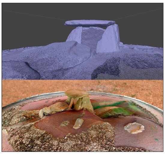
Figure 10.
Above, model without texture after processing with Metashape. Below, published model with complete processing.
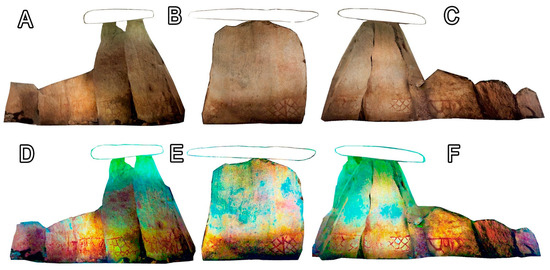
Figure 11.
Orthomosaics: above, photorealistic (A–C). Below, enhanced (D–F). (A–C) are different views.
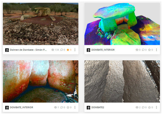
Figure 12.
3D models collection of Dombate dolmen.
Once the complete study has been presented, the links where the results of the three sites can be studied are provided below. To facilitate the presentation of the models in an orderly manner, a classification into three groups has been established. The first group encompasses the models of all sites with a refined texture, the second group includes the enhanced models that employ the DStretch correlation techniques, and the third group comprises models created using stop motion, which enables the observation of real-time changes between the preceding two studies.
Textured 3D Model:
- Dombate: https://skfb.ly/6QUAt (Tumulus) (accessed on 12 September 2024)
- Dombate: https://skfb.ly/ouoIn (Engravings)( accessed on 12 September 2024)
- Chã dos Cabanos: https://skfb.ly/oUSzK (accessed on 12 September 2024)
- Chã da Escusalha: https://skfb.ly/otKAN (accessed on 12 September 2024)
- DStretch 3D Model:
- Dombate: https://skfb.ly/ouoGY (accessed on 12 September 2024)
- Chã dos Cabanos: https://skfb.ly/oWoUz (accessed on 12 September 2024)
- Chã da Escusalha: https://skfb.ly/oQnZZ (accessed on 12 September 2024)
- Stop Motion Textured-DStretch 3D Model:
- Dombate: https://skfb.ly/oWpnv (accessed on 12 September 2024)
- Chã dos Cabanos: https://skfb.ly/oWp68 (accessed on 12 September 2024)
- Chã da Escusalha: https://skfb.ly/oWoWt (accessed on 12 September 2024)
4. Conclusions
The results demonstrate the successful application of SfM-MVS photogrammetry in the construction of 3D models in complex environments, such as megalithic archaeological sites. Considering the Dombate dolmen’s intricate nature makes it noteworthy that comprehensive documentation of the monument was achieved within an hour. It is also remarkable that standardised SfM photogrammetry protocols typically restrict the use of artificial illumination to fixed light sources. This is due to the variation in light conditions between consecutive photographs, particularly in terms of its direction, which hinders the homologous identification of common features by SfM algorithms. Therefore, although the use of flash is practically non-existent in previous studies, the improvement of SfM algorithms and the computing power and performance of the present hardware already allow images to be correlated adequately, and their use should be encouraged.
The materials and methods used are low-cost despite the use of commercial software; Metashape Standard Edition contains all the resources necessary to carry out the study and is priced at US$ 59 for the educational version and US$ 179 for the enterprise version. Nevertheless, an exhaustive search was carried out, and the characteristics of the following software packages were reviewed:
- Meshroom 2023 3.0
- Coolmap 3.11.0.dev0
- VisualSFM 0.5.26
- OpenMVG v2.1
- Regard3D 1.0.0
- OpenSFM 0.5
- Telesculptor 1.2.0
All of them seem to be excellent tools, and in all of them, the authors could see detailed models with a good quality finish. Therefore, it would not be fair to say that it is not possible to carry out the work presented in this paper if one has not worked intensively with each of the programs. It can be stated that in general terms, the user interface is more limited, in some cases a command line, and that the workflow, although very well developed, is less intuitive than in the case of Metashape, nor was automatic target detection found in any of the packages during the review, and it is not known whether the SfM-MVS algorithms are as complete and efficient as in the case of Metashape. All in all, we cannot claim that the use of open-source software is not an equally viable alternative. That could be part of a future study, where the results obtained with the different programmes could be compared, the advantages and disadvantages of each could be precisely determined, and, if desired, the cost of modelling could be further reduced.
To obtain a thorough, complete, and detailed study, the documentation was complemented with engraving and cave painting enhancement techniques. The data were integrated into a 3D format for dissemination via web media, thus creating a product that is accessible to both professionals and the public. The online repository provides metrics on viewing, downloading, or interaction for statistical tracking. A multitude of specialists can study these archaeological sites in great detail without having to access them. This allows the sites to be preserved in their original state, which can lead to new hypotheses about their construction or help to clarify aspects on which there is still no consensus among experts. An illustrative example is the Dombate dolmen, the date of which concerning the construction of the site remains to be established [34,35,36,37]. The techniques employed in this study enabled a comprehensive and accurate documentation of the engravings while also revealing a notable subsidence of certain orthostats. While this observation does not directly corroborate any of the hypotheses, it provides a robust foundation for reaching a consensus on the number of carvings of “the thing” and whether they were created before or after the construction of the dolmen.
Author Contributions
Conceptualisation and methodology, S.P.-V.; writing—original draft preparation, supervision and funding acquisition, M.G.-D.; visualisation and software, J.O.-S.; investigation and data curation, L.V.B.; resources, project administration and funding acquisition, A.M.S.B., writing—review, formal analysis and editing, M.F.C. All authors have read and agreed to the published version of the manuscript.
Funding
This research was funded by the Xunta de Galicia through the grants for the consolidation and structuring of competitive research units in the universities of the Galician University System (2023–2025), Ref. ED431B 2023/17, and the postdoctoral training stage in the universities of the Galician University System (2021–2024), Ref. ED481B-2021-069. Additionally, this work was supported by the Fundação para a Ciência e a Tecnologia (FCT) through the grant awarded to Luciano Vilas Boas under the project ‘Mortuary landscapes during the Recent Prehistory in the river basins of the Lima and Neiva rivers, Northwest Portugal’, Ref. UIDB/04683/2020, part of the Multiyear Archaeological Research Project (PIPA).
Data Availability Statement
Data is contained within the article.
Acknowledgments
The authors would like to express their gratitude to the Diputación de la Coruña and the collective “A Rula” for their invaluable support and collaboration in developing this study.
Conflicts of Interest
The authors declare no conflicts of interest.
References
- Münster, S.; Friedrichs, K.; Hegel, W. 3D Reconstruction Techniques as a Cultural Shift in Art History. Int. J. Digit. Art Hist. 2019, 3, 39–59. [Google Scholar]
- Giovannini, E.C.; Verdiani, G.; Cardinali, V. Priene, a Monumental Disaster in the Aegean: Digital Approaches to the Doric Stoa’s and the Theater’s Lost Evidence. Heritage 2024, 7, 4538–4561. [Google Scholar] [CrossRef]
- Carvajal, D.A.L.; Morita, M.M.; Bilmes, G.M. Virtual Museums. Captured Reality and 3D Modeling. J. Cult. Herit. 2020, 45, 234–239. [Google Scholar] [CrossRef]
- Hernández-Muñoz, Ó. Analysis of Digitized 3D Models Published by Archaeological Museums. Heritage 2023, 6, 3885–3902. [Google Scholar] [CrossRef]
- Guarnieri, A.; Milan, N.; Vettore, A. Monitoring Of Complex Structure For Structural Control Using Terrestrial Laser Scanning (Tls) And Photogrammetry. Int. J. Arch. Herit. 2013, 7, 54–67. [Google Scholar] [CrossRef]
- Dong, Z.; Liang, F.; Yang, B.; Xu, Y.; Zang, Y.; Li, J.; Wang, Y.; Dai, W.; Fan, H.; Hyyppä, J.; et al. Registration of large-scale terrestrial laser scanner point clouds: A review and benchmark. ISPRS J. Photogramm. Remote Sens. 2020, 163, 327–342. [Google Scholar] [CrossRef]
- Volanis, G.; Galanakis, D.; Bolanakis, N.; Maravelakis, E.; Borg, R.P.; Stavroulakis, G.E. Modelling and Stability Assessment of the Rock Cliffs and Xrobb l-Ġħaġin Neolithic Structure in Malta. Heritage 2024, 7, 2944–2958. [Google Scholar] [CrossRef]
- Aicardi, I.; Chiabrando, F.; Lingua, A.M.; Noardo, F. Recent trends in cultural heritage 3D survey: The photogrammetric computer vision approach. J. Cult. Herit. 2018, 32, 257–266. [Google Scholar] [CrossRef]
- Gil-Martín, L.M.; Hdz.-Gil, L.; Kohrangi, M.; Menéndez, E.; Hernández-Montes, E. Fragility Curves for Historical Structures with Degradation Factors Obtained from 3D Photogrammetry. Heritage 2022, 5, 3260–3279. [Google Scholar] [CrossRef]
- Chetverikov, B.; Hlotov, V.; Bakuła, K. Development of a Software Module for Studying Historical and Cultural Heritage Objects Using Non-Invasive Research Data. Heritage 2024, 7, 4131–4148. [Google Scholar] [CrossRef]
- Angheluță, L.M.; Popovici, A.I.; Ratoiu, L.C. A Web-Based Platform for 3D Visualization of Multimodal Imaging Data in Cultural Heritage Asset Documentation. Heritage 2023, 6, 7381–7399. [Google Scholar] [CrossRef]
- Chaves, E.; Aguilar, J.; Barontini, A.; Mendes, N.; Compán, V. Digital Tools for the Preventive Conservation of Built Heritage: The Church of Santa Ana in Seville. Heritage 2024, 7, 3470–3494. [Google Scholar] [CrossRef]
- Pervolarakis, Z.; Zidianakis, E.; Katzourakis, A.; Evdaimon, T.; Partarakis, N.; Zabulis, X.; Stephanidis, C. Three-Dimensional Digitization of Archaeological Sites—TheUse Case of the Palace of Knossos. Heritage 2023, 6, 904–927. [Google Scholar] [CrossRef]
- Peña-Villasenín, S.; Gil-Docampo, M.; Ortiz-Sanz, J. 3-D modeling of historic façades using SFM photogrammetry metric documentation of different building types of a historic center. Int. J. Arch. Herit. 2017, 11, 871–890. [Google Scholar] [CrossRef]
- Peña-Villasenín, S.; Gil-Docampo, M.; Ortiz-Sanz, J. Professional SfM and TLS vs a simple SfM photogrammetry for 3D modelling of rock art and radiance scaling shading in engraving detection. J. Cult. Herit. 2019, 37, 238–246. [Google Scholar] [CrossRef]
- León-Bonillo, M.J.; Mejías-García, J.C.; Martínez-Álvarez, R.; Pérez-Romero, A.M.; León-Ortíz, C.; Marín-Buzón, C. SfM Photogrammetric Techniques Applied in the Building Archaeology Works of the Old Cloister of the Monastery of San Francisco from the 16th Century (Cazalla de la Sierra, Seville). Heritage 2022, 5, 3901–3922. [Google Scholar] [CrossRef]
- Pérez-García, J.L.; Mozas-Calvache, A.T.; Gómez-López, J.M.; Vico-García, D. Multiscale 3D Documentation of the Medieval Wall of Jaén (Spain) Based on Multi-Sensor Data Fusion. Heritage 2023, 6, 5952–5966. [Google Scholar] [CrossRef]
- Furukawa, Y.; Ponce, J. Accurate camera calibration from multi-view stereo and bundle adjustment. Int. J. Comput. Vis. 2009, 84, 257–268. [Google Scholar] [CrossRef]
- Barbero-Álvarez, M.A.; Brenner, S.; Sablatnig, R.; Menéndez, J.M. Preserving Colour Fidelity in Photogrammetry—An Empirically Grounded Study and Workflow for Cultural Heritage Preservation. Heritage 2023, 6, 5700–5718. [Google Scholar] [CrossRef]
- Martínez, S.; Ortiz, J.; Gil, M.L. Aplicación de la fotogrametría digital automatizada para la documentación técnica de pavimentos históricos. Caso particular de Santiago de Compostela. Span. J. Rural Dev. 2013, 4, 131–144. [Google Scholar] [CrossRef]
- Carrero-Pazos, M.; Vilas-Estévez, B.; Vázquez-Martínez, A. Digital imaging techniques for recording and analysing prehistoric rock art panels in Galicia (NW Iberia). Digit. Appl. Archaeol. Cult. Herit. 2012, 8, 35–45. [Google Scholar] [CrossRef]
- Le Quellec, J.-L.; Duquesnoy, F.; Defrasne, C. Digital image enhancement with DStretch®: Is complexity always necessary for efficiency? Digit. Appl. Archaeol. Cult. Herit. 2015, 2, 55–67. [Google Scholar] [CrossRef]
- Gil-Docampo, M.; Peña-Villasenín, S.; Ortiz-Sanz, J. An accessible, agile and low-cost workflow for 3D virtual analysis and automatic vector tracing of engravings: Atlantic rock art analysis. Archaeol. Prospect. 2020, 27, 153–168. [Google Scholar] [CrossRef]
- Grottoli, E.; Biausque, M.; Rogers, D.; Jackson, D.W.T.; Cooper, J.A.G. Structure-from-motion-derived digital surface models from historical aerial photographs: A new 3D application for coastal dune monitoring. Remote Sens. 2020, 13, 95. [Google Scholar] [CrossRef]
- Peña-Villasenín, S.; Gil-Docampo, M.; Ortiz-Sanz, J. Digital Documentation and Architectural Heritage Restoration with 3-D Geometry: The Ambulatory of the Cathedral of Santiago de Compostela. Int. J. Arch. Herit. 2024, 1–21. [Google Scholar] [CrossRef]
- Lowe, G. SIFT—The Scale Invariant Feature Transform. Int. J. 2004, 2, 91–110. [Google Scholar]
- Chandran, V.; Carswell, B.; Boashash, B.; Elgar, S. Pattern recognition using invariants defined from higher order spectra: 2-D image inputs. IEEE Trans. Image Process. 1997, 6, 703–712. [Google Scholar] [CrossRef]
- Lowe, D.G. Object recognition from local scale-invariant features. In Proceedings of the Seventh IEEE International Conference on Computer Vision, Kerkyra, Greece, 20–27 September 1999; Volume 99, pp. 1150–1157. [Google Scholar]
- Snavely, N.; Seitz, S.M.; Szeliski, R. Modeling the world from internet photo collections. Int. J. Comput. Vis. 2008, 80, 189–210. [Google Scholar] [CrossRef]
- Furukawa, Y.; Ponce, J. Accurate, dense, and robust multiview stereopsis. IEEE Trans. Pattern Anal. Mach. Intell. 2010, 32, 1362–1376. [Google Scholar] [CrossRef]
- Furukawa, Y.; Curless, B.; Seitz, S.M.; Szeliski, R. Towards internet-scale multi-view stereo. In Proceedings of the IEEE Computer Society Conference on Computer Vision and Pattern Recognition, San Francisco, CA, USA, 13–18 June 2010; pp. 1434–1441. [Google Scholar] [CrossRef]
- Vilas-Boas, L.; Peña-Villasenín, S.; Santos-Bettencourt, A.M. The relationship between megalithic monuments and rock art in Mosteirô, Ponte da Barca, northwest Portugal. In Human Challenges in a Context of Changing Landscapes, Book of Abstracts of the Landscape Archaeology Conference; Alcalá University: Alcalá de Henares, Spain, 2024; p. 295. Available online: https://lac2024.com/wp-content/uploads/2024/06/Book-of-Abstracts-LAC2024.pdf (accessed on 12 September 2024).
- ZainEldin, H.; Elhosseini, M.A.; Ali, H.A. Image compression algorithms in wireless multimedia sensor networks: A survey. Ain Shams Eng. J. 2015, 6, 481–490. [Google Scholar] [CrossRef]
- Pérez, F.V. La historia de las intervenciones. In El Dolmen de Dombate: Arqueología, Arquitectura y Conservación; Diputación de A Coruña: Coruña, Spain, 2011; pp. 47–137. ISBN 978-84-9812-146-9. [Google Scholar]
- Del Moral, F.C.; Rodríguez, J.Y. Otros estudios técnicos. In El Dolmen de Dombate: Arqueología, Arquitectura y Conservación; Diputación de A Coruña: Coruña, Spain, 2011; pp. 267–310. ISBN 978-84-9812-146-9. [Google Scholar]
- Xosé, A. El Dolmen de Dombate Enmascara Fórmulas Megalíticas Más Antiguas. La Voz de Galicia. 2018. Available online: https://www.lavozdegalicia.es/noticia/carballo/2018/02/28/dolmen-dombate-enmascara-formulas-megaliticas-antiguas/0003_201802C28C7994.htm (accessed on 12 September 2024).
- Cristina, V. Dombate Segue a Sorprendermos. La Voz de Galicia. 2017. Available online: https://www.lavozdegalicia.es/noticia/carballo/cabana-de-bergantinos/2017/09/26/dombate-segue-sorprendermos1700-horas-1830-horas/0003_201709C26C12991.htm (accessed on 12 June 2023).
Disclaimer/Publisher’s Note: The statements, opinions and data contained in all publications are solely those of the individual author(s) and contributor(s) and not of MDPI and/or the editor(s). MDPI and/or the editor(s) disclaim responsibility for any injury to people or property resulting from any ideas, methods, instructions or products referred to in the content. |
© 2024 by the authors. Licensee MDPI, Basel, Switzerland. This article is an open access article distributed under the terms and conditions of the Creative Commons Attribution (CC BY) license (https://creativecommons.org/licenses/by/4.0/).