Article

Field Model-Based Cultural Diffusion Patterns and GIS Spatial Analysis Study on the Spatial Diffusion Patterns of Qijia Culture in China

1
Center for Glacier and Desert Research, College of Earth and Environmental Sciences, Lanzhou University, No. 222 South Tianshui Road, Lanzhou 730000, China
2
Chinese Department, School of Humanities and Communication, Changji University, Changji 831100, China
*
Author to whom correspondence should be addressed.
Remote Sens. 2022, 14(6), 1422; https://doi.org/10.3390/rs14061422
Submission received: 6 January 2022 / Revised: 12 March 2022 / Accepted: 13 March 2022 / Published: 15 March 2022
(This article belongs to the Special Issue Remote Sensing of Watershed)

Abstract

:
Cultural diffusion is one of the core issues among researchers in the field of cultural geography. This study aimed to examine the spatial diffusion patterns of the Qijia culture (QJC) to clarify the origin and formation process of Chinese field model-based cultural diffusion patterns (FM-CDP) and geographic information system (GIS) spatial analysis methods. It used the point data of Qijia cultural sites without time information and combined them with the relevant records of Qijia cultural and historical documents, as well as archaeological excavation materials. Starting with the spatial location information of cultural distribution, it comprehensively analysed the cultural hearth, regions, diffusion patterns, and diffusion paths. The results indicated the following. (1) The QJC’s heart is in the southeast of Gansu Province, where the Shizhaocun and Xishanping sites are distributed. (2) Five different levels of cultural regions were formed, which demonstrated different diffusion patterns at different regional scales. On a large regional scale, many cultural regions belong to relocation diffusion patterns. Meanwhile, at the small regional scale (in the Gansu–Qinghai region), there are two patterns of diffusion: expansion diffusion and relocation diffusion; however, the expansion diffusion pattern is the main one. (3) Based on the relationship between the QJC, altitude, and the water system, the culture also has the characteristics of diffusion to low altitude areas and a pattern of diffusion along water systems. (4) There is a circular structure of the core, periphery, and fringe regions of the QJC. Finally, (5) the dry and cold climate around 4000a B.P., the cultural exchange between Europe and the Asian continent (the introduction of barley, wheat, livestock and sheep, and copper smelting technology), and the war in the late Neolithic period were important factors affecting the diffusion of the QJC.

Graphical Abstract

1. Introduction

Research on the origin of Chinese civilisation has attracted extensive attention since the 20th century [1]. Since the 21st century, with the launch of the ‘source exploration project of Chinese civilisation’, the exploration of the origin of Chinese civilisation has entered a new stage [2]. The Qijia culture (QJC) was formed in the late Neolithic period, in 4300–3500a B.P. This is roughly equivalent to the history of the Xia Dynasty. It laid the tone for Chinese civilisation, and has become the focus of exploring the origin of Chinese civilisation [3]. The spatial diffusion of the QJC has provided valuable contributions to the extensive scientific projects of the origin exploration project of Chinese civilisation [1,4]. It is also helpful to explore the development track of prehistoric culture from region to continent more clearly. Many studies show that the prehistoric social process, especially the rise and fall of ancient civilisations, is related to the spatial expansion of ancient culture [5]. For example, in the development of the Chinese civilisation, cultural expansion played a role in promoting the evolution from Neolithic culture to Bronze Age culture [6]. Therefore, exploring the spatial diffusion patterns of the QJC can help us understand the origin of Chinese civilization.
Since the 1980s, owing to the rapid growth of China’s economy, the number of archaeological field investigations and excavations has exponentially increased [7]; this work has given rise to a wealth of data for future generations [8,9]. Regionally, research on the QJC is limited to certain regions. These include the eastern or north-eastern Tibetan Plateau, the Loess Plateau, and the Gansu and Qinghai regions [10]. Therefore, the current research on the QJC is limited to the small area listed above, and there are few studies on the QJC in the Yellow River Basin and the whole of China. In terms of research content, existing studies have mainly focused on the classification of the QJC using stages and types [11], agricultural and economic forms [12], and features of tombs [13]. For example, regarding the division of stages and types of the QJC, Xie Duanju divides the QJC into the eastern region (the eastern region of Gansu, including the Jingshui River, Weihe River, and the upper reaches of the Western Han River), the central region (the central region of Gansu, including the upper reaches of the Yellow River and its tributaries, the Taohe River basin, and the Daxia River basin), and the western region (western Gansu province and eastern Qinghai Province, including the upstream of the Yellow River in Qinghai province and its tributaries, the HuangShui and Hexi corridor) [11]. Ye Maolin et al. discussed the agricultural and economic forms of the QJC period based on millets, animal remains, bone needles, jade and stone tools, and other relics unearthed from the QJC site [12]. As for the study of tombs, Xie Duanju et al. made a comprehensive preliminary summary of the shape and structure of the tombs, burial tools, and burial products based on the burial materials unearthed in the Qijia cultural site [11]. The above research provides rich information for an in-depth discussion of related QJC issues. However, it only takes the excavated relics as the main research object from the perspective of history and archaeology, and uses the qualitative description method to summarize the macro research on related content. The research content is relatively simple. There is a lack of research using quantitative and qualitative methods for specific issues of QJC. For example, the cultural hearth of the QJC has not been adequately researched. There are few relevant historical records, and most of the available materials are mixed with myths and legends, which have low credibility. Therefore, Han Jianye and other relevant scholars, based on archaeological excavation data and the types and forms of unearthed artefacts, believe that the southeast Gansu province, representing the remains of the seventh period of Shi Zhaocun of Tianshui, is the hearth of the QJC [14]; however, this study lacks verification based on quantitative methods. Most studies on the spatial diffusion of the QJC focus on the expansion scope of the QJC. Li Shuicheng and Dong Guanghui have outlined the spatial scope of QJC in Ganqing based on the existing cultural relics survey results and archaeological survey reports [15]. How did the QJC spread out from its cultural hearth? At present, there is a lack of research on the diffusion patterns of the cultural region formed by cultural diffusion.
Geographic information system (GIS) technology was initially applied to archaeological research, regional systematic investigation and site planning, prehistoric settlement and environmental archaeology, and prehistoric cultural sites [16]. For example, Gaffney and others used GIS to study the territorial boundary, land use, and site selection factors of the Hvar region [17]. Van Leusen discussed the relationship between the site vision difference and its functional difference of South Limburg in the south of the Netherlands through cluster analysis [18]. In the application of GIS in heritage protection planning, Nanjing Normal University first developed the GIS system for archaeological sites in the lower reaches of the Yangtze River, and discussed the role of GIS in archaeological information management systems [19]. The application of GIS in settlement and environmental archaeology mainly focuses on social complexity and population research. For example, Liu Jianguo used GIS to study the archaeological and social complexity of settlements in the Linfen basin, Luoyang basin, Huanhe, Qixing River, and Meiyang River [20]. The application of GIS spatial analysis in the field of prehistoric culture research mainly focuses on the study of the spatial distribution and pattern of prehistoric cultural sites. For example, WuLi et al. compared and analysed the spatial and temporal distribution characteristics of prehistoric cultures in Zhejiang since the Holocene based on GIS spatial analysis [21]. Dominic Hosner et al. studied the spatial and temporal distribution pattern of 51,074 archaeological sites from the Neolithic to the Iron age in China based on GIS spatial analysis [22]. In general, people pay increasingly more attention to the research on prehistoric culture supported by GIS. However, few studies have applied GIS spatial analysis and cultural diffusion patterns to prehistoric culture.
The main purpose of this paper is to assess the diffusion patterns of the QJC in space. However, the time information of most Qijia cultural sites is missing. The field model-based cultural diffusion pattern (FM-CDP) model studies the spatial diffusion mode of the QJC without the time information, mainly generating the density surface of the distribution of cultural sites according to the dispersion degree of the QJC sites. By calculating the density surface, the distance between the QJC sites is skilfully transformed into the mutual relationship of QJC. To complete the transformation of the QJC from “point” diffusion to the “surface” of cultural region, we extract the cultural hearth, cultural region, diffusion patterns, and internal classification structure of the QJC space diffusion, and quantitatively describe QJC space diffusion [23,24,25,26]. Therefore, the FM-CDP model plays an important role in the analysis of QJC diffusion. It is a method of cultural diffusion based on the field model, that is, by using the point data of a cultural event, it detects cultural areas at different levels, automatically identifies their spatial diffusion mode, and calculates the spatial diffusion relationship between cultural areas. Zhang Haiping [25,26] verified the effectiveness of the FM-CDP by analysing the spatial diffusion patterns of rural places in China. The results showed that the FM-CDP can effectively identify the existing cultural diffusion patterns using the point data of specific cultural characteristics. This method can also be applied to analyse other cultural diffusion patterns that represent certain cultural phenomena in the form of point features. Because the QJC site data lack information on time, it is difficult to study the spatial diffusion of the QJC. Therefore, this article embarks from the space perspective of geography, with the strong objectivity of archaeological reports and the basis of historical documents to confirm each other, on the basis of the theory of cultural geography spatial diffusion, based on the cultural diffusion model (FM-CDP), from the spatial location information of the distribution of cultural sites, to explore its cultural hearth and its diffusion patterns. This provides a new idea for the study of prehistoric culture without time information.

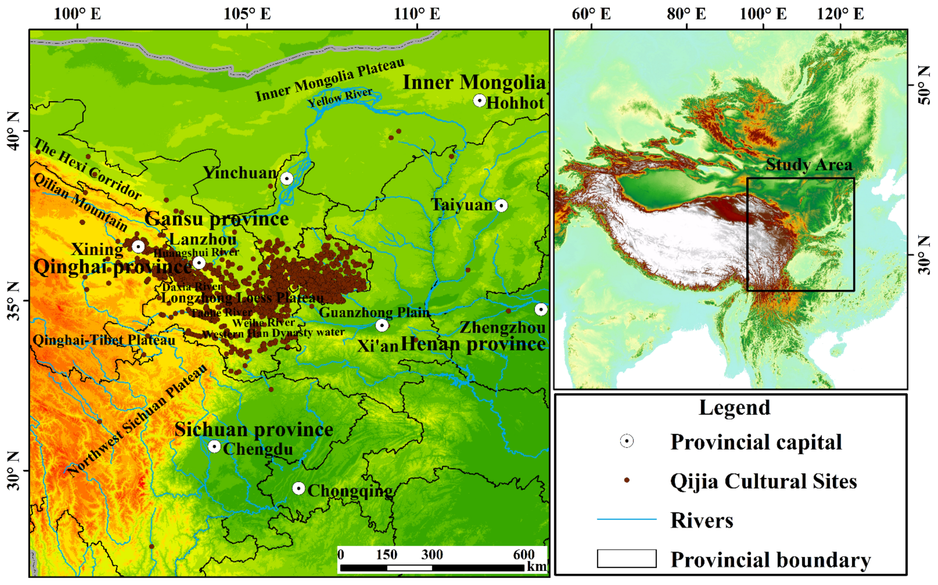
Regional Environments

According to currently known archaeological excavation data and historical documents, there are more than 3000 sites with QJC characteristics in mainland China. These sites are mainly distributed in the Yellow River Basin and its tributaries [11]. The distribution ranges from the eastern foot of the Qinghai–Tibet Plateau in the west to the Guanzhong Plain in the east [27], and from the Inner Mongolia Plateau in the northwest to the Sichuan Plateau in the south [28,29]. Regarding the administrative division, it extends west to Qinghai Province [30,31], east to Henan Province [32], north to Inner Mongolia Alxa [27], and south to Sichuan Province [33]. However, the core region of its distribution is in Gansu Province [34].
Qijia culture is mainly distributed in the intersection of the Qinghai–Tibet Alpine region, the eastern monsoon region, and the arid northwest region (Figure 1). The regional climate difference is obvious, and the annual average temperature and annual precipitation are also different. The annual average temperature is as high as 12 °C and as low as −6 °C [35]. The highest annual precipitation is 800 mm, and the lowest is less than 50 mm. The climate gradually becomes drier from the southeast to the northwest, and the vegetation gradually changes from grassland to desert, which is the transition zone from semi-humid to semi-arid to arid. Climatic conditions and the natural environment are relatively harsh, with strong sensitivity and instability [36]. Therefore, human activities in this region are greatly influenced by the natural environment more than other regions in the same latitude. The main distribution area of the culture is the intersection of the Qinghai–Tibet plateau, Loess Plateau, and Inner Mongolia Plateau, with complex and diverse landforms. The lowest altitude is less than 600 m, and the highest is more than 6000 m. The terrain characteristics are obviously different, mainly including mountains, plateaus, plains, and basins. The region includes the Qilian Mountains, Hexi Corridor, Loess Plateau, and other topographic areas. Such complex topographic features promote or hinder the diffusion of the Qijia culture [35]. At lower altitudes, the hydrothermal conditions are better, the loess accumulation is thicker, and the cultivation conditions are better. Therefore, most of the QJC is distributed at lower altitudes. The QJC was mainly distributed in the middle and lower reaches of the Yellow River Basin, including Weishui, Taohe, Daxia, and Huangshui [36]. Rivers are affected by terrain, and most of their flow direction is consistent with the direction of mountains and terrain. The sites are generally located on loess platforms on both sides of rivers, and are close to water sources.

2. Materials and Methods

2.1. Sources of Archaeological Information

The first national survey of cultural relics in 1956 left no statistical data; therefore, the data of the Qijia cultural sites used in this study have been taken from the results of the second National Survey of Cultural Relics conducted by the State Administration of Cultural Heritage from 1981 to 1985: the Atlas of Chinese Cultural Relics Gansu Volume, the Atlas of Chinese Cultural Relics Qinghai Volume, the Atlas of Chinese Cultural Relics Ningxia Volume, the Atlas of Chinese Cultural Relics Inner Mongolia Volume, the Atlas of Chinese Cultural Relics Shaanxi Volume, the Atlas of Chinese Cultural Relics Shanxi Volume, the Atlas of Chinese Cultural Relics Sichuan Volume, the Atlas of Chinese Cultural Relics Henan Volume, Thirty Years of Cultural Relics and Archaeology, Fifty Years of Archaeology in New China, Sixty Years of Chinese Archaeology, Archaeological Discoveries and Research in New China, Chinese Archaeology—Neolithic Age Volume, and an excavation briefing of the relevant sites. Among them, most of the data were collected from the results of the second national cultural relics census hosted by the State Administration of Cultural Relics from 1981–1985 [37,38,39,40,41,42,43,44]. According to the published archaeological excavation briefs and historical documents, no distribution of QJC was found in other Chinese provinces. Therefore, it was not included in this study’s data collection scope. The Atlas of Chinese Cultural Relics in the provinces used in this study consists of a site location map and a concise description. The atlas provides relatively comprehensive coverage of all known sites obtained through rescue, archaeological excavation, systematic investigation, and accidental discovery. However, the specific geographical coordinates of each site and the specific activity age data of the site point in the map set were missing. Therefore, it was impossible to use the conventional mathematical statistical model such as quantitative analysis based on statistics and behavioural geography to study the related culture [45,46,47]. The DEM data used in this study primarily came from the GDEMV3 30M resolution digital elevation data jointly released by NASA and METI on 5 August 2019. The data format is Geo TIFF (signed 16 bits). Users can download it from the Geospatial data cloud platform of the computer network information centre of the Chinese Academy of Sciences (http://www.gscloud.cn, accessed on 5 August 2019). In addition, China’s administrative boundaries, rivers, provincial capitals, and other data were derived from the 1:250,000 topographic element data of the State Bureau of Geographic Surveying and Mapping Information.

2.2. Data Processing

In this study, the QJC data are represented by QJC sites or sites with Qijia cultural elements; however, the scales and areas of these sites are inconsistent. To unify the data format, points are used in this study to represent the QJC; that is, a point represents a QJC site (see Figure 2a). Before analysing the diffusion patterns of the QJC, it was necessary to process the cultural sites’ data. First, an Excel table of basic information such as the number, specific site name, administrative affiliation, longitude, latitude, site area, altitude, and other basic information of each Qijia cultural site was developed. Since the specific geographical coordinates of most sites were unknown, it was necessary to locate the coordinates based on the site location, administrative division, and text descriptions of geographical locations within the map. This work, combined with the use of Google Earth to obtain the data with decimal coordinate values according to the geographical location and administrative division of the site points in the relevant cultural relics’ atlas, facilitated the direct use of the ArcGIS 10.3 software. After obtaining the corresponding coordinate values, we used the ‘coordinate inverse check’ function in Google Maps to check the sites to ensure the accuracy of their positioning. Second, the point layer was created using ArcGIS 10.3 based on the Excel table data. We selected the GCS_ WGS_ 1984 coordinate system, used Add X Y Data in the file to load the created Excel table, and selected the corresponding longitude and latitude values in the X and Y drop-down menus. After the point layer was generated, the output data were the vector point data in the Shapefile format. Finally, in the geographic coordinate systems (GCS) and projected coordinate systems (PCS), by taking ‘m’ as the unit of site point data, the decimal latitude and longitude data were added. We selected the WGS_1984 coordinate system in GCS; in order to perform the data calculation, we changed the data unit to m and selected WGS_1984_UTM_Zone_48N from the PCS. We ensured the correct coordinate system during data analysis.

2.3. FM-CDP Diffusion Model

The FM-CDP model is a quantitative model based on the theory of cultural diffusion. It explores the mode of cultural space diffusion based on the GIS field model method, and visually expresses the cultural spatial diffusion model [22,23,24,25,26]. This model was originally used to investigate the spatial diffusion pattern of the place name cluster. This is because the data sources of the Qijia cultural site and the place name cluster do not have time attributes, and merely possess point elements that show the status. However, this type of prehistoric culture has continuity. Therefore, this model can effectively explore the spatial diffusion patterns of the QJC. The FM-CDP model is composed of three sub-models: DCR (detection of cultural region), RDT (recognition for diffusion types of cultural region), and ISCD (inferring for internal structure of cultural diffusion). The DCR model is mainly used to identify cultural hearths and detect cultural regions. The RDT method recognises the diffusion patterns of cultural regions, and the ISCD model infers the internal structure of cultural diffusion.
The FM-CDP model is a method used by Zhang Haiping et al. that uses the results of the second national census of place names to solve the problem that some elements of place names have time attributes, but most of them do not. GIS is used to quantify the analytical method; the cultural diffusion model is proposed around the question of “how to use quantitative methods to mine the cultural spatial diffusion patterns of place names and cultural hearth” [22,23,24,25,26]. Cultural diffusion is regarded as a continuous process because its boundary is fuzzy. The field model in GIS can efficiently solve the problem of boundary fuzziness and continuous change in space. As a result, the model, based on the GIS field model and the use of distribution on the space of a cultural phenomenon or event of point data, tests the different levels of cultural regions, automatically identifies the spatial diffusion types of cultures and the spatial diffusion relations between cultural regions, and effectively determines the cultural diffusion patterns on the basis of point elements [22,23,24,25,26]. In addition, this common method can be applied to the analysis of other cultural diffusion patterns that are represented by point elements. This model emphasises the expansion and relocation diffusions based on the relationship between distance and neighbours in geospatial space.
The GIS field model is one of the most basic GIS data models [22,23,24,25,26]. The GIS field model emphasises the continuous features of geographic objects. Based on raster data, the model can construct a smooth and continuously changing density surface on the basis of a certain cultural feature point in space, such that high-density regions can be recognised well and the spatial relationship between these regions can be calculated to a certain extent. On the one hand, a field model is better for modelling continuous phenomena and geographical boundaries with fuzzy borders, such as the analysis of mountains, temperature, and pollutant diffusion. Therefore, a field model is generally used to solve these problems. On the other hand, a field model can be converted into a data structure, such as contour lines, which can reflect hierarchy. The density surface of an area of cultural phenomena and elements is located in the region with the locally highest value. We can extract the local maxima of the density surface of cultural phenomena, such as extracting the peaks of mountains, by using a digital elevation model (DEM), providing a reference for detecting cultural regions [26]. In identifying cultural region types, the cultural phenomenon itself exhibits blurred boundaries, but a field model is good at extracting spatial relationships from continuous surface models, and thus identifying cultural diffusion types in cultural regions becomes possible. Moreover, a field model can efficiently extract the diffusion pattern from the characteristics of GIS spatial analysis, because the density surface constructed by the point features is hierarchical. Obtaining a high-density cultural region or calculating the type of diffusion in a cultural region is relatively easy.

3. Results

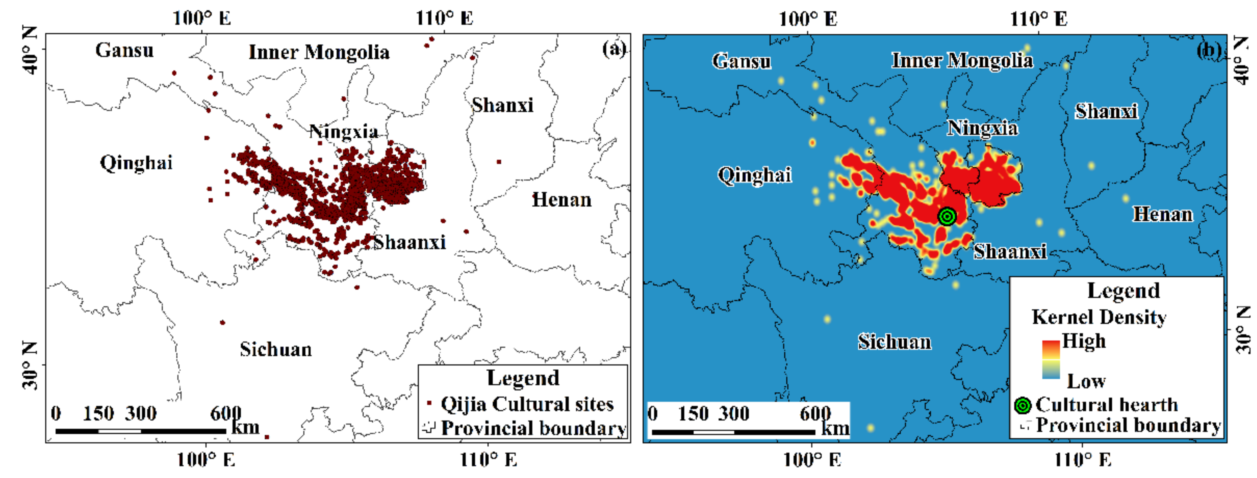
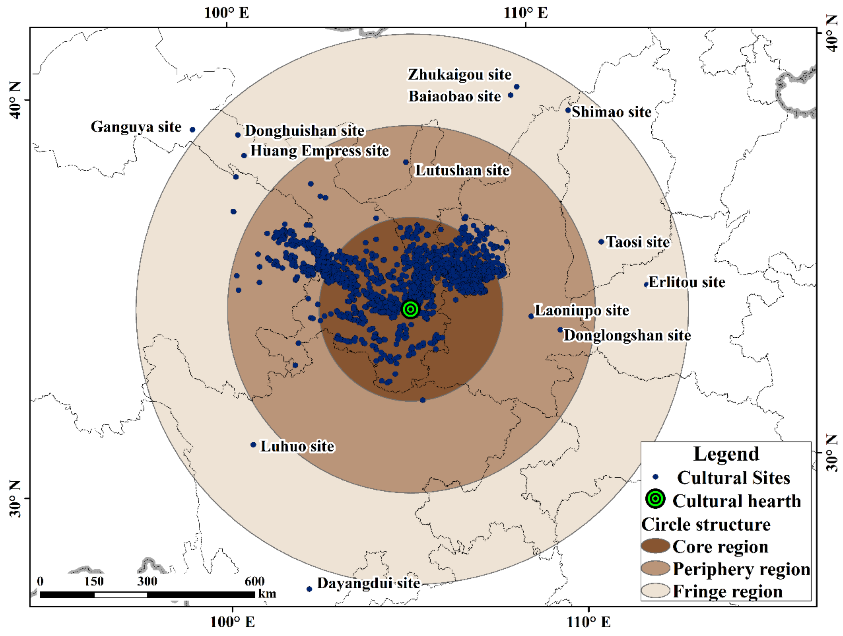
3.1. Qijia Cultural Hearth and Cultural Regions

The cultural hearth was the place where specific cultural aspects, phenomena, or systems originated. Based on the FM-CDP cultural diffusion model and the GIS database of Qijia cultural site points, the points were converted into a density-based grid surface. The local maximum of the new grid was obtained using the GIS field model, and the hearth of QJC was obtained according to the difference between the density-based surface field, Figure 2b, and the local maximum of the new grid. Through the archaeological excavation data related to the QJC, the literature, and the distribution range of cultural site clusters [37,38,39,40,41,42,43,44], it was verified that the eastern part of Gansu Province was dictated by the Shizhaocun and Xishanping sites as the cultural hearth of the QJC [14]. Therefore, this study took its distribution area as the hearth of the QJC for follow-up analysis.
Through the FM-CDP sub model DCR and the spatial distribution characteristics of the QJC, several cultural regions were obtained (Figure 3). Based on the kernel density analysis, the sub model transforms the distance between cultural sites into the interaction relationship of cultural sites through the density calculation, and completes the transformation of culture diffusion from “points” to “surfaces” of cultural regions. Figure 3 shows that a continuous and smooth density surface field was obtained according to the Qijia cultural points with different weights in the search area. This indicates that the hot spots with a high density and a certain scale were Qijia cultural areas. According to the scale and size of the cultural regions, they were divided into five different levels. Level 1 indicates that the distribution scope and density of the QJC are the largest, and Level 5, the smallest. Based on the spatial distribution of the cultural regions, several major paths that diffused from the cultural hearth of the QJC were manually drawn to obtain several main diffusion directions. These included the Hexi Corridor, Inner Mongolia Plateau, Northwest Sichuan Plateau, and Guanzhong Basin. The Northwest Sichuan Plateau and Guanzhong region formed a far-reaching diffusion path.

3.2. Spatial Diffusion Patterns of QJC

We used the FM-CDP sub-models, RDT and ISCD, to quantitatively identify the diffusion mode of the QJC and its diffusion patterns at the large regional scale (Figure 4a). We also used the small regional scale in the Gansu–Qinghai region (Figure 4b). Among them, the blue cultural region is the result of relocation and diffusion, and the relocation diffusion pattern is represented by a broken line. The red cultural region is the result of expansion diffusion, which is represented by a solid line. The results show that the expansion diffusion pattern at a large regional scale changes into the coexistence of expansion and relocation at a small regional scale in the Gansu–Qing region. At the small regional scale, the QJC is a diffusion pattern with expansion as the primary and relocation as the auxiliary pattern. Th expansion diffusion was the result of diffusion near the cultural hearth, whereas the result of relocation diffusion was far away from the cultural hearth.
Regarding the specific regions, the QJC mainly diffused westward to the Hexi Corridor, and even to the terraces of the Hehuang (water) River Valley and its tributaries in the eastern agricultural area of Qinghai on the south-eastern edge of the Tibetan Plateau. It diffused eastward to the Guanzhong Plain and southward to the Xianshui River, a tributary of the Yalong River. It also diffused northward to the Hetao area of the Inner Mongolia Plateau. However, the main diffusion area was in the Yellow River Basin.
Based on the diffusion model, the diffusion path map of the QJC is obtained as shown in Figure 5. The density of the points representing cultural phenomena varies by cultural regions; additionally, their distribution ranges are also different. Therefore, as combined with the density value and distribution range, the cultural region is divided into five levels. At a large regional level, the cultural region directly or indirectly connected with the cultural hearth belongs to the expansion diffusion pattern. Conversely, it is the relocation diffusion pattern. Figure 5 indicates that relocation diffusion occurs mainly in smaller cultural regions. Observing the diffusion pattern around the cultural hearth, we noted that several high-level cultural regions formed near the cultural hearth. The closer a region is to the cultural hearth, that is, the closer it is to the southeast of Gansu province, the higher its level of Qijia culture. This indicates that the characteristics of the Qijia cultural elements are clear: the further away from the cultural hearth—that is, the closer to the Hexi Corridor Area, Hetao area, Guanzhong Plain, Northwest Sichuan Plateau, and other areas—a region is, the lower its level of Qijia culture (i.e., there are fewer and less obvious Qijia cultural elements).

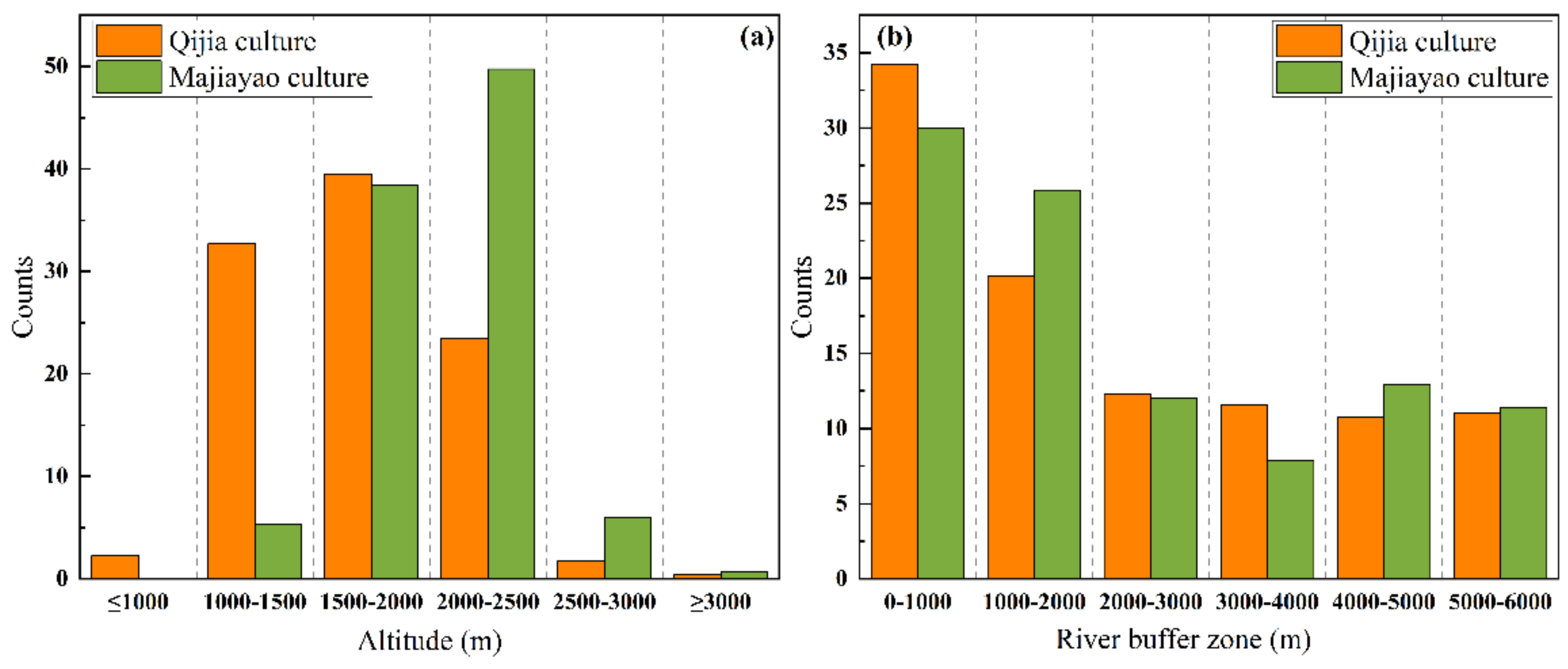
3.3. Characteristics of QJC Diffusion to Low Altitude

Majiayao culture and QJC are both Neolithic cultures with roughly the same spatial distribution [31,36]. In order to better explore the diffusion characteristics of the QJC, Majiayao culture is selected for comparative analysis. Due to the influence of natural geographical factors such as climate, water sources, and topography in the distribution area of Qijia cultural sites, the QJC has the spatial distribution characteristics of relative dispersion at a large regional scale and relative concentration on a small regional scale [48]. Compared with the Majiayao culture, the QJC has an expanded spatial distribution range and obvious south diffusion characteristics. The centre of gravity retreats to the south of 36°N. In low altitude areas with dense rivers, the culture significantly increased. Simultaneously, the QJC has an obvious diffusion trend from the upper reaches of the Yellow River to the middle and lower reaches of the river.
The relationship between the spatial distribution and altitude of the QJC and the Majiayao culture was obtained from the ArcGIS 13.0 spatial analysis tool (Figure 6a). By taking the distribution frequency of cultural sites as the index and considering the selection of cultural sites at different elevations in the same cultural era, there was a change in the number of cultural sites of the Majiayao culture and the QJC at an elevation of 2000 m; therefore, 2000 m was selected as the elevation critical value. As can be seen from the bar chart in Figure 6, the Majiayao culture accounts for 56.34% of the areas above 2000 m, showing the characteristics of concentrated distribution at high altitude. The proportion of QJC and Majiayao culture sites below 2000 m is 74.39% and 43.66%, respectively. It shows that the QJC has the characteristics of spreading more to low altitude areas compared to the Majiayao culture.

3.4. ‘Water Diffusion’ of QJC

The QJC period involved a low-level stage of social development. The natural environment had a significant restrictive effect on human production and life. The ancestors of the Qijia people mainly lived near water to adapt to and make use of their natural environment. Finally, the water system facilitated cultural diffusion.
The ArcGIS 13.0 spatial analysis tool was used to analyse the buffer zone of the water system in the distribution area of the QJC and the Majiayao culture at an interval of 1000 m (Figure 6b). This was where the cultural points with 0 m that were not in the buffer zone were deleted without statistical analysis to obtain the relationship between the spatial distribution of the QJC, the Majiayao culture, and the water system. The histogram indicates that the QJC and the Majiayao culture are mainly distributed within 2000 m of the river, accounting for 54.5% and 55.8%, respectively. This indicated that both QJC and prehistoric culture have the characteristics of a concentrated distribution near water. Within 3000 m of the river buffer zone, the QJC accounts for 66.6% of the total culture, and the Majiayao culture accounts for 67.8% of the total culture. Compared with the QJC, the Majiayao culture was concentrated within 3000 m of the river, indicating that, compared with the Majiayao culture, the cultural diffusion of the QJC could not be separated from the support of the water system, and the diffusion characteristics along the water system were obvious.
The QJC takes the cultural hearth as the centre and mainly diffuses to the surrounding areas along the main stream of the Yellow River and its tributaries. The Yellow River connected the QJC in the east, west, north, and south regions in a series to form a point axis structure. It was then extended to the north and south, showing the characteristics of scattering from the east, west, north, and south.

3.5. Circular Structure of Qijia Culture

The circular structure of the QJC occurred as a result of its spatial diffusion. After nearly 800 years of continuous diffusion, the QJC diffused along the Yellow River and its tributaries to the southeast edge of the Tibetan Plateau, northwest Sichuan Plateau, Inner Mongolia Plateau, Guanzhong Plain, and other regions. This is where it formed a circular structure (Figure 7). According to the theory of cultural geography, the cultural characteristics of the cultural hearth area are the most obvious and typical. With an increase in the distance from the cultural hearth area, the cultural characteristics gradually weaken, conforming to the principle of distance attenuation, and finally disappear [49]. Given the lack of time information of most Qijia cultural sites, the Qijia cultural region has been detected based on the ArcGIS 13.0 buffer analysis function. After several tests, the results are the most ideal when the search radius is 260 km, without considering topography and other factors. Therefore, taking the cultural hearth area of Qijia as the core, 260 km as the radius parameter, and province as the basic unit to establish the buffer zone, the core area of the spatial diffusion of the QJC can be obtained. When the radius parameters are 520 km and 770 km, the sphere and domain regions of culture are formed.
The cultural core area is close to the cultural hearth, and the number of cultures account for 83.0% of the total cultures. According to the theory of cultural geography, the spatial diffusion and influence of cultural phenomena are consistent with the attenuation law of spatial distance [50]. The Qijia population was the core of the group with cultural characteristics and the development of cultural inheritance, as well as an important foundation for cultural diffusion. The closer the spatial distance from the cultural hearth, the more likely the Qijia group was to accept the culture; in turn, the stronger the popularity of the culture and the more significant the cultural phenomenon. Therefore, a cultural core region dominated by an expansion diffusion pattern was formed. The number of QJCs in the sphere area of culture accounted for 16.7%, which was a common result of expansion and relocation diffusion. With the increase in spatial distance, the understanding and identity of the Qijia people in this culture decreased compared with that of the cultural core region. The popularity of the culture decreased, and the cultural phenomenon became increasingly unclear. It thus formed a spherical cultural region with less clear Qijia cultural elements. The marginal area was formed by relocation diffusion, and the number of QJCs in this area was only 0.3%. This indicated that with the increase in spatial distance, the resistance to cultural diffusion gradually increased, and was greatly affected by the culture of the adjacent regions. This reduced the influence and audience of this culture compared with other cultures in the same period to form a dominant cultural region with no obvious Qijia cultural elements.

4. Discussion

4.1. Applicability of FM-CDP Cultural Diffusion Model

Under the external driving force and the internal power of its own survival and development, cultural diffusion occurs in space [51]. Similarly, as a kind of culture, the QJC diffused around under the external driving force of the prehistoric environment and the internal driving force of culture. In the field of cultural diffusion research, there are four main methods to study cultural diffusion at present: the semiquantitative analysis method based on maps [52,53,54], quantitative analysis methods based on statistics [55,56,57], quantitative analysis methods based on behaviour geography [58,59], and FM-CDP [22,23,24,25,26]. Semiquantitative analysis methods based on maps distinguish the diffusion of a cultural phenomenon through observation [60]. Quantitative analysis methods based on statistics help determine cultural diffusion primarily through observation maps or simple statistical analyses [61]. Quantitative analysis methods based on behaviour geography mainly apply to the study of cultural diffusion in time and space [58]. For complex cultural phenomena, it is difficult to use the first three semiquantitative methods to describe the spatial diffusion patterns of a culture. In addition, from the perspective of structuralism, the first three methods lack reliable quantitative analysis models, so their analysis results are not rigorous. In addition, most quantitative methods based on spatial statistics usually disregard the paradigm of cultural diffusion in traditional cultural geography; furthermore, a complete system that illustrates cultural origins, cultural regions, and types of cultural diffusion and their internal structures is lacking. Methods based on traditional spatial analysis also exhibit the same defects. The diffusion of the QJC is a long process that took hundreds of years, and it is not easy for researchers to discover it. Therefore, the absence of relevant information such as the time of diffusion leads to the absence of long-term sequence data in the data source. Therefore, it is difficult to infer cultural diffusion using the first three methods. However, the cultural diffusion pattern analysis method (FM-CDP) based on a field model in GIS can detect different levels of cultural regions, and identify the diffusion patterns of these cultural regions.
The QJC is a cultural distribution with space and region as the carrier created by the ancestors of Qijia through practice in a certain geographical environment. The spatial diffusion of its culture is a relatively long process that takes hundreds of years to complete. It is a cultural phenomenon with a significant geographical proximity effect and continuous spatial processes. Cultural diffusion is mainly restricted by traditional geographical distances, and the boundary of cultural diffusion is ambiguous. Since it is a prehistoric culture, it is impossible to obtain specific temporal or other information on cultural diffusion. Therefore, the data are different from the general point data of modern times. Existing time information on most Qijia cultural sites is missing, and quantitative analysis of QJC based on time has become a challenge. However, the cultural diffusion model analysis method using the GIS field model (FM-CDP), based on the powerful spatial analysis function of GIS, can overcome the shortcomings of QJC, such as the non-computability of a lack of time information.

4.2. Influencing Factors of Spatial Diffusion of QJC

Based on the above research results, we can further analyse the reasons for the spatial diffusion of the QJC, which are mainly climatic factors and non-climatic factors.

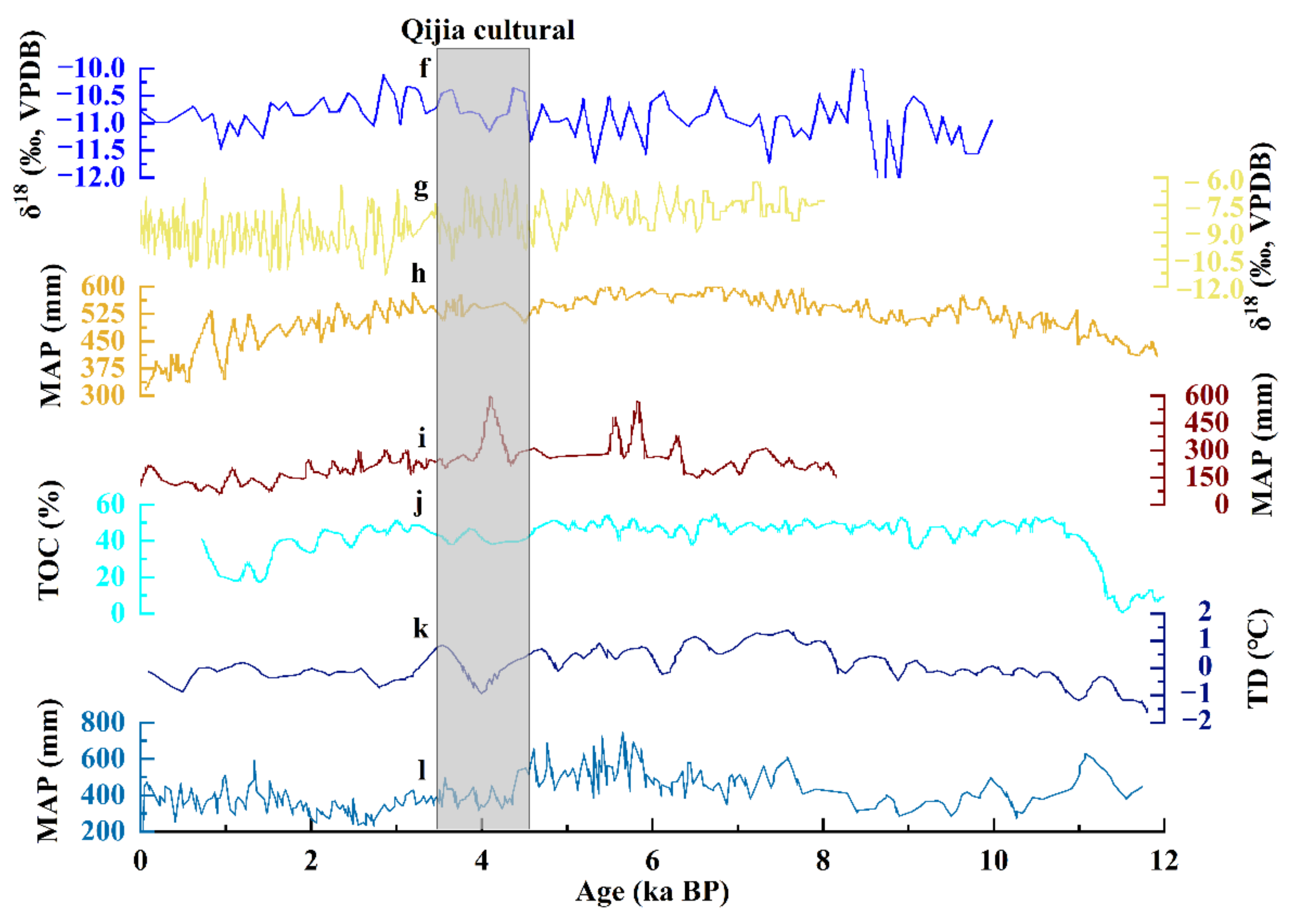
4.2.1. Climatic Factors of Spatial Diffusion of QJC

The QJC is a late Holocene culture from around 4000a B.P. [62,63]. The temperate continental climate and temperate monsoon climate zones of the area played an important role in the spatial diffusion of local Holocene culture [64,65,66]. The reconstruction of climate history in the late Holocene by relevant scholars, especially from around 4000a B.P., provides a favourable foundation for exploring the relationship between QJC and climate change [8,9].
Combined with related research results on climate change in the Gansu and Qinghai areas and their surroundings, the climatic factors of the spatial diffusion of the QJC were systematically analysed. Through the summary of many climatic and environmental proxy indicators, it was found that during the late Holocene, especially around 4000a B.P., there were cooler and drier climatic events [67,68,69] and the climate accordingly cooled and dried.
From the perspective of the core region of the distribution of the QJC, it has been found that the climate in Gansu was in a state of low temperature and drought during the QJC period (Figure 8). For example, climate proxies, such as magnetic susceptibility, organic matter, and pollination of the loess profile in Gansu indicate that the monsoon was generally strong and humid before 4000a B.P. After 4000a B.P., the monsoon strongly retreated and the climate rapidly dried [70].
From the perspective of the surrounding area where the QJC spread (Figure 9), Sichuan has a southern latitude and numerous river systems compared to Gansu. During the QJC period, the total organic carbon content in the Ruoergai Red plain peat was low, indicating that the area was warmer and wetter than Gansu during the QJC period [73]. Shaanxi, located in the Guanzhong region, was significantly affected by the East Asian monsoon. Compared to Gansu in the same period, the climate was warmer and wetter, and water was abundant. According to the oxygen isotope records of the Jiuxian cave, there was more precipitation in the region during the Qijia period [74,75]. The conditions of animal husbandry in Inner Mongolia and Ningxia were better. The paleoclimate records of the Daihai basin show that the precipitation range in Inner Mongolia changed little, which provided favourable growth conditions for the emergence of large grasslands in central and southern Inner Mongolia; these met the needs of animal husbandry development [76]. It can be seen from the oxygen isotope records of the Dunde ice core in the Qilian Mountains that during the QJC period, the temperature dropped and the vegetation changed significantly, from the former forest or forest steppe to the steppe environment, and the prehistoric ancestors adopted the mixed mode of animal husbandry and planting. Henan, located in the Central Plains, is a semi-humid continental climate zone with abundant precipitation, and the basin plain can conveniently use the water resources of the Yi-Luo River and other rivers. Precipitation fluctuation has little influence on regional cultural development. After the Holocene drying and cooling event at about 4000a B.P., the climate in this region was still sub-humid. Although the annual precipitation decreased, it was still higher than the minimum precipitation required for dryland agriculture, thus providing favourable conditions for the diffusion of the QJC to this region [77,78,79]. The above shows that when the climate in the Gansu–Qinghai region tends to be dry and cool, the vegetation belt moves to the north and south, which in most cases will drive people with different economic modes to move from north to south, thus leading to the diffusion of the QJC to the surrounding areas that are more conducive to survival [80].
In addition, the climate changed from relatively warm and wet to cool and dry around 4000a B.P. In the warm and humid stage, the river was fully replenished, and the ancestors lived at a moderate distance from the river [75]. After entering the cool and dry stage, the continuous cool and dry climate led to changes in the industrial structure during the Qijia period. Millet and primitive millet agriculture that relied on hydrothermal conditions declined, and animal husbandry increased and became dominant [83,84]. To solve the shortage of food resources and maintain stable productivity and life, ancestors with primitive agriculture as their main mode of production migrated to low altitudes and river valleys with better hydrothermal conditions [85]. In addition, studies have shown that water resources were more dependent on rivers [5] due to the low productivity of prehistoric society and the fact that living near water was the main mode of production of ancient humans. Therefore, the diffusion patterns of QJC to low altitudes and water systems were formed.
In conclusion, climate change caused by the change of temperature, precipitation, and other factors led to a low level of productivity for the ancestors who lived in this environment. The ability of the people to respond to the changes in the natural environment was low. This forced them to lower elevations, with a combination of drainage and hot conditions, as it was more suitable for the development of farming and animal husbandry [86].

4.2.2. Non-Climatic Factors of Spatial Diffusion of QJC

The spatial diffusion of the QJC was not only affected by climate change, but also by cultural exchanges, wars, and other factors in Eurasia, such as the emergence of wheat crops, livestock and sheep, and bronze smelting technology, to name but a few.

Exchange of Cultures between Europe and Asia

Around 4000a B.P., the introduction of barley and wheat [87,88], sheep [89], and metallurgical technology from the European continent to China occurred [90,91], along with the spread of Chinese millet to Europe [92]. The ‘prehistoric food globalisation’ promoted communication and exchange between cross-continental cultures [93]. This transcontinental cultural element was introduced into China in the form of the ‘cultural package’ [94]. It improved the ability of the prehistoric ancestors to adapt to the environment [95]. It also accelerated the diffusion of the QJC to the surrounding areas to a certain extent in the dry and cold environments.

War and Chaos

In addition, the warm and humid environment in the early stage of the QJC led to the continuous expansion of the Qijia population and the gradual prominence of the contradiction between man and land. This caused existing levels of productivity to fail to keep up with the pressures of large-scale populations and the continuous war and conflict between different cultural groups. These factors promoted the diffusion of culture to a certain extent [96].
For example, the human bones buried in the martyrdom pit found in the Xishanping site are all men aged 20–40 years [96]. Among the five random burial tombs—M35, M36, M57, M58, and M62—found in the fourth excavation of the Huang Niangniangtai site in Wuwei City, there are no fixed burial types. Some have sullied skeletons, separated heads, incomplete limbs, or no heads, and there are almost no funerary objects [96]. The phenomenon of martyred human burial was found in the Mogou Qijia cultural cemetery. The martyred humans included men and women, both old and young. Although women and children were the main burials, they did not completely follow the practice of male superiority, which was the result of the war. Perhaps in the course of the war, most men on the defeated side were killed and eventually martyred, while women and children were captured, so women and children accounted for a large proportion of the surviving captives [97]. The above shows that these people did not die normally, and that the dead were victims of increasingly frequent tribal conflict or tribe wars [98]. This may reflect that the diffusion of the QJC was affected by war. In addition, in the QJC period, war was more common. As a form of war defence, it is generally believed that the city site appeared to meet the needs of war. Now, the Huanhao settlements of the QJC period have been found. For example, in the Qijia cultural site in Qinghai Province, three large moats with a width of more than 10 m and a depth of 5–6 m have been found, and Huanhao settlements also exist in the Shenna site [99,100].
In conclusion, the influence of natural environmental factors such as climate on cultural diffusion is greater than that of social factors such as cultural exchange and war (Table 1). During the QJC period, productivity was low, and the prehistoric ancestors could not well understand and master some natural laws; therefore, they could only change their way of life, such as using subsistence strategies, according to the climate and other natural environmental factors, so as to conform to nature. Some researchers believe that ancient civilizations would have been favoured when the climate deteriorated to the limit of human endurance. Resource shortage leads to increased social complexity, which leads to an ecological adjustment of human cultural behaviour [101]. The national migration during the cooling period may also adjust the social structure, leading to the outbreak of large-scale wars, and eventually to the diffusion of culture [102].

5. Conclusions

Based on the data from Qijia cultural sites with a lack of time information, this study explored the diffusion patterns of the QJC by using the spatial diffusion model (FM-CDP) based on the GIS field model and obtained the following conclusions:
(1)
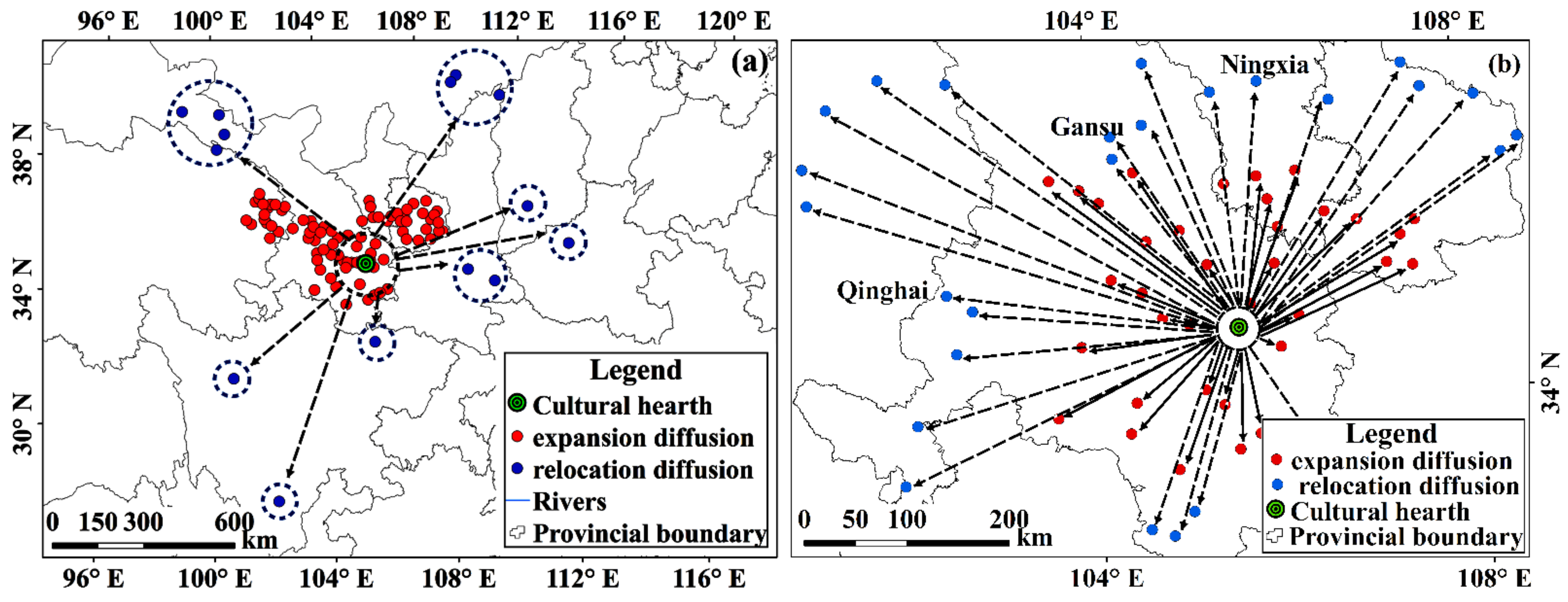
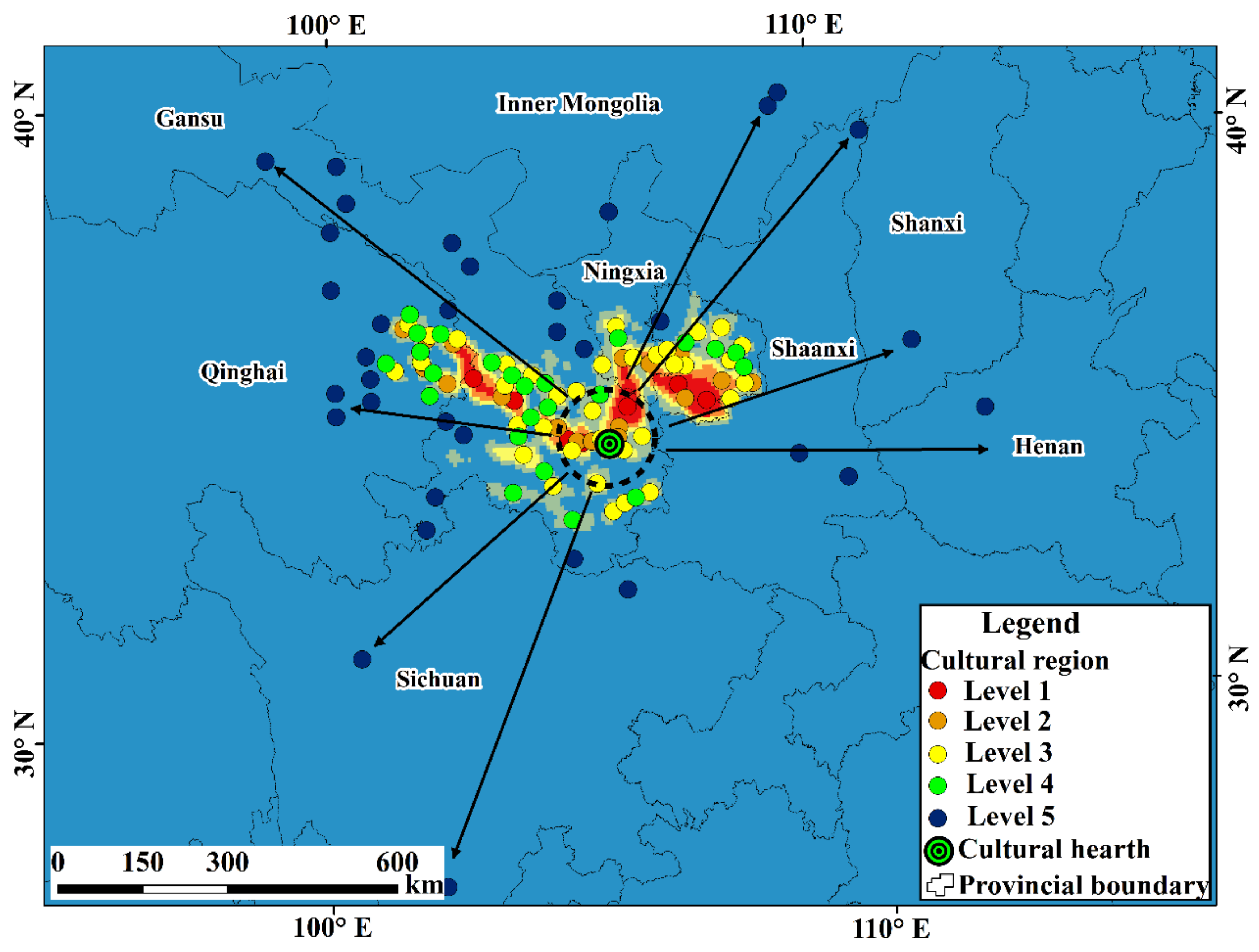
The QJC has different diffusion patterns at different regional scales, and the spatial diffusion pattern of the QJC has the characteristic trend of near-geographical unit elements at the same regional scale. This shows that the spatial diffusion patterns of the QJC vary, not only with different spatial scales, but also with changes in different geographical units. From the perspective of the regional scale, the diffusion of the QJC to the Guanzhong basin, northwest Sichuan Plateau, Inner Mongolia Plateau, and Hexi Corridor was far away from the cultural source; therefore, it was primarily relocation diffusion. The diffusion of culture in the regions close to the cultural hearth and southeast Gansu was mainly expansion diffusion. On the small regional scale, the culture in Gansu and Qinghai provinces not only has the pattern of expansion diffusion, but also relocation diffusion.
(2)
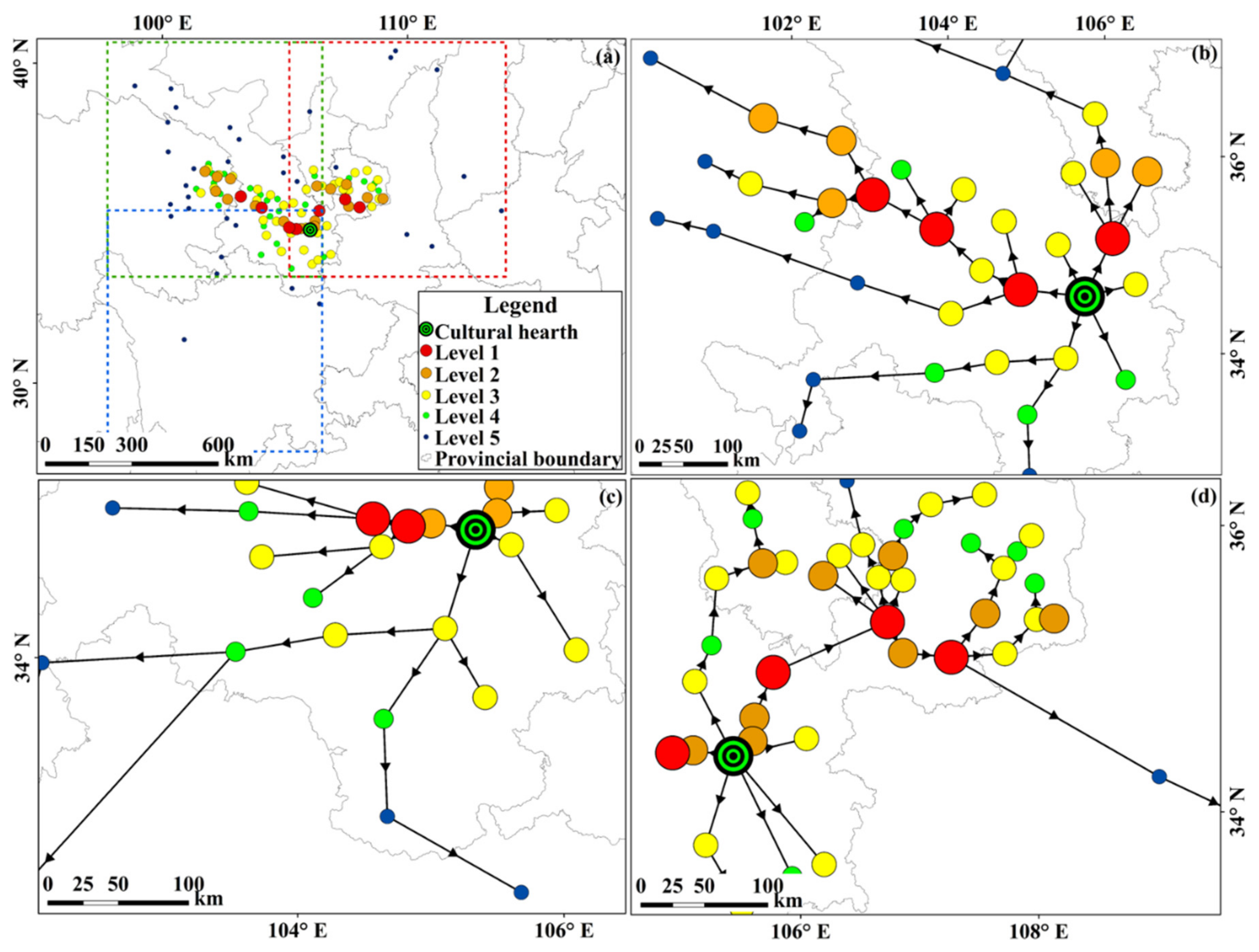
The QJC forms a circular structure in the process of spatial diffusion, and different diffusion patterns form different cultural circles. Expansion diffusion is the main diffusion pattern of the core cultural region. The cultural sphere is the common result of expansion diffusion and relocation diffusion, and the pattern of relocation diffusion forms the cultural domain. The culture in the southeast of Gansu province is close to the cultural hearth and is mainly expansion diffusion, thus forming the cultural core region. Cultural diffusion in central Qinghai, Gansu, and southern Ningxia, which are far away from the cultural hearth, forms the sphere region. Sichuan, Henan, and Inner Mongolia, which are far from the cultural hearth, form the domain region of cultural diffusion.
(3)
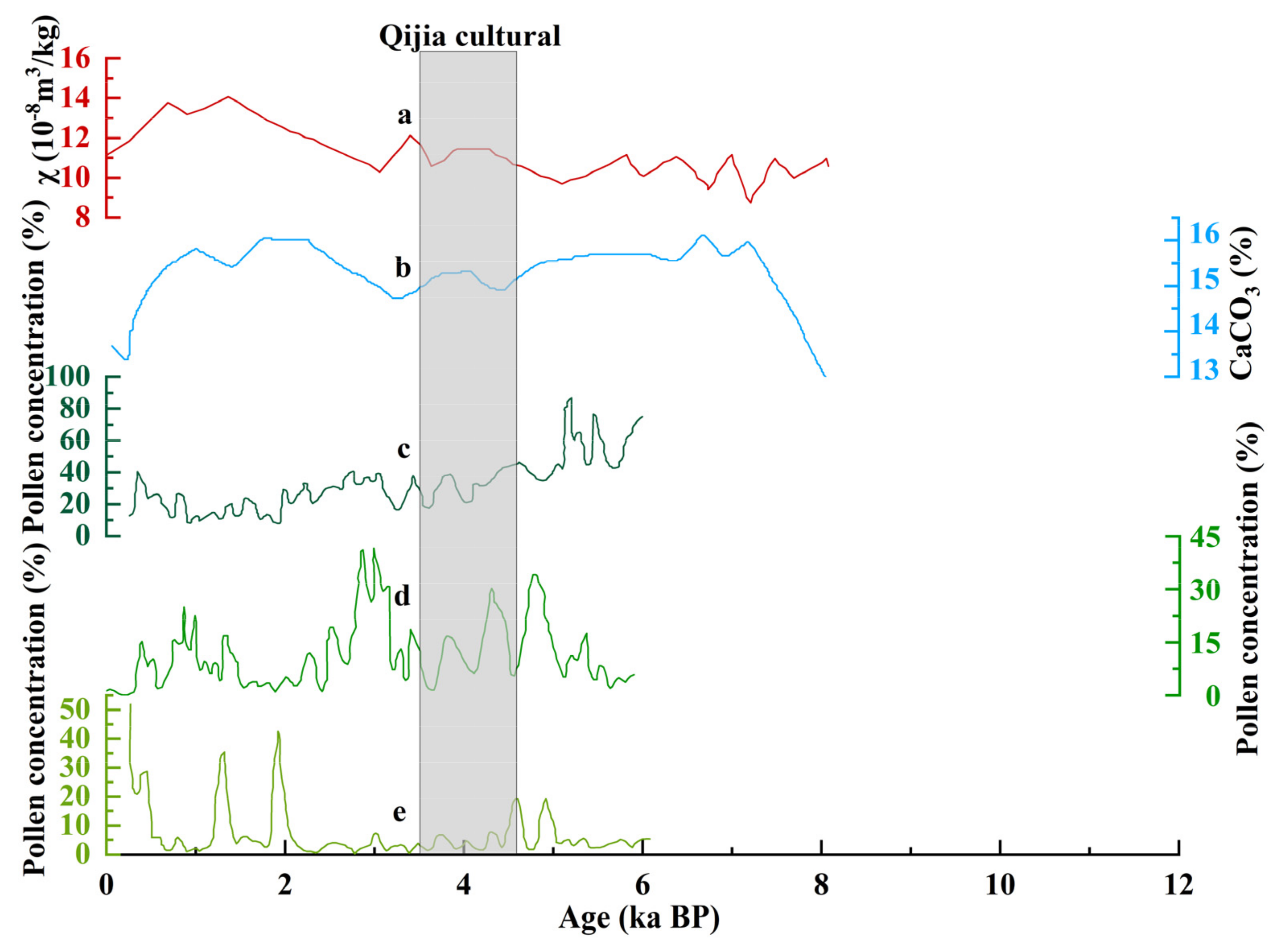
The spatial diffusion of the QJC is closely related to the climatic and social environments of the time. In the late Neolithic period, temperature and precipitation decreased and the climate tended to be dry and cool. During the same period, Sichuan, Henan, and Shaanxi had a warmer and more humid climate and sufficient water resources than Gansu, which was conducive to the survival of the QJC ancestors. Meanwhile, central and southern Inner Mongolia, southern Ningxia, and the Hexi Corridor could meet the needs of the livelihood patterns of semi-farming and semi-grazing. Cultural exchange across Eurasia, the introduction of copper smelting technology, and tribal wars may have also promoted the diffusion of QJC. In addition, the wars between tribes may have been an influencing factor.
This study illustrates the spatial diffusion pattern of the QJC at different regional scales and its influencing factors. The results of its spatial diffusion pattern reproduce the spatial diffusion process of the QJC. They also deepen and expand the research dynamics of prehistoric cultural space and enrich research on the QJC. The result of cultural diffusion is that culture moves from pluralism to integration, with advanced cultural factors from various places converging in the same region. Therefore, it is helpful to study the origins of Chinese civilisation. The role of climate in cultural diffusion may provide a historical reference for contemporary man to predict and address future climate change. However, the diffusion pattern of the prehistoric culture in China and globally, which still lacks time information, needs further examination.

Author Contributions

Conceptualization, Y.W. (Yuanyuan Wang); Proposed the idea and designed the study, N.W.; Implemented the method, X.Z. and X.L.; software, Y.W. (Yuanyuan Wang); validation, Y.W. (Yuanyuan Wang) and N.W.; formal analysis, Y.W. (Yuanyuan Wang); investigation, Y.W. (Yuanyuan Wang) and X.L.; resources, N.W.; data curation, N.W. and Y.W. (Yuanyuan Wang); writing—original draft preparation, Y.W. (Yuanyuan Wang), X.Z., J.L. and P.Y.; writing—review and editing, Y.W. (Yipeng Wang), N.W. and X.Z.; visualization, Y.W. (Yixin Wang); supervision, N.W.; project administration, N.W.; funding acquisition, N.W. All authors have read and agreed to the published version of the manuscript.

Funding

This research was funded by National Natural Science Foundation of China, grant number 41871021 and the Key Project of the National Natural Science Foundation of China, grant number 41530745.

Institutional Review Board Statement

Not applicable.

Informed Consent Statement

Not applicable.

Data Availability Statement

The data presented in this study are available on request from the corresponding author.

Conflicts of Interest

The authors declare no conflict of interest. The funders had no role in the design of the study; in the collection, analyses, or interpretation of data; in the writing of the manuscript, or in the decision to publish the results.

References

  1. Urbanus, J. China’s Hidden City Recent discoveries at an isolated northern settlement are challenging traditional narratives about the origins of Chinese civilization. Archaeology 2019, 72, 34–37. [Google Scholar]
  2. Jing, Y.; Campbell, R. Recent archaeometry research on ‘the origins of Chinese civilisation’. Antiquity 2009, 83, 96–109. [Google Scholar] [CrossRef]
  3. Gao, S.; Yang, Y.; Xu, Y.; Zhang, Q.; Zhu, H.; Zhou, H. Tracing the genetic history of the Chinese people: Mitochondrial DNA analysis of a neolithic population from the Lajia Site. Am. J. Phys. Anthropol. 2007, 133, 1128–1136. [Google Scholar] [CrossRef] [PubMed]
  4. Ma, Z.; Tang, S. Qijia Culture and Chinese Civilization, 1st ed.; Publisher Gansu Nationalities Publishing House: Lanzhou, China, 2015; pp. 360–361. [Google Scholar]
  5. Xu, J.; Jia, Y.; Ma, C.; Zhu, C.; Wu, L.; Li, Y.; Wang, X. Geographic distribution of archaeological sites and their response to climate and environmental change between 10.0–2.8 ka BP in the Poyang Lake Basin, China. J. Geogr. Sci. 2016, 26, 603–618. [Google Scholar] [CrossRef] [Green Version]
  6. Li, F.; Wu, L.; Zhu, C.; Zheng, C.; Sun, W.; Wang, X.; Shao, S.; Zhou, Y.; He, T.; Lie, S. Spatial-temporal distribution and geographic context of Neolithic cultural sites in the Hanjiang River Basin, Southern Shaanxi, China. J. Archaeol. Sci. 2013, 40, 3141–3152. [Google Scholar] [CrossRef]
  7. Wagner, M.; Tarasov, P.; Hosner, D.; Fleck, A.; Ehrich, R.; Chen, X.; Leipe, C. Mapping of the spatial and temporal distribution of archaeological sites of northern China during the Neolithic and Bronze Age. Quat. Int. 2013, 290, 344–357. [Google Scholar] [CrossRef]
  8. Li, Y.; Qiang, M.; Huang, X.; Zhao, Y.; Leppanen, J.; Weckstrom, J.; Valiranta, M. Lateglacial and Holocene climate change in the NE Tibetan Plateau: Reconciling divergent proxies of Asian summer monsoon variability. Catena 2021, 199, 7. [Google Scholar] [CrossRef]
  9. Cai, Y.; Cheng, X.; Ma, L.; Mao, R.; Breitenbach, S.F.M.; Zhang, H.; Xue, G.; Cheng, H.; Edwards, R.L.; An, Z. Holocene variability of East Asian summer monsoon as viewed from the speleothem delta O-18 records in central China. Earth Planet. Sci. Lett. 2021, 558, 12. [Google Scholar] [CrossRef]
  10. Feng, Z.; Sun, A.; Abdusalih, N.; Ran, M.; Kurban, A.; Lan, B.; Zhang, D.; Yang, Y. Vegetation changes and associated climatic changes in the southern Altai Mountains within China during the Holocene. Holocene 2017, 27, 683–693. [Google Scholar] [CrossRef]
  11. Xie, D. Prehistoric Archaeology in the Gansu and Qinghai Region, 1st ed.; Cultural Relics Publishing House: Beijing, China, 2002; pp. 111–130. [Google Scholar]
  12. Lu, H.; Yang, X.; Ye, M.; Liu, K.; Xia, Z.; Ren, X.; Cai, L.; Wu, N.; Liu, T. Millet noodles in Late Neolithic China—A remarkable find allows the reconstruction of the earliest recorded preparation of noodles. Nature 2005, 437, 967–968. [Google Scholar] [CrossRef]
  13. Zhang, Y.; Huang, C.; Pang, J.; Guo, Y.; Zhou, Q. Identification of the prehistoric catastrophes at the Lajia Ruins using micromorphological analysis within the Guanting Basin, Minhe County, Qinghai Province. Archaeol. Anthropol. Sci. 2018, 10, 711–723. [Google Scholar] [CrossRef]
  14. Han, J. The Development and Evolution of Qijia Culture: Cultural Interaction and Eurasian Background. Cult. Relics 2019, 7, 60–65. [Google Scholar]
  15. Dong, G.; Jia, X.; Elston, R.; Chen, F.; Li, S.; Wang, L.; Cai, L.H.; An, C. Spatial and temporal variety of prehistoric human settlement and its influencing factors in the upper Yellow River valley, Qinghai Province, China. J. Archaeol. Sci. 2013, 40, 2538–2546. [Google Scholar] [CrossRef]
  16. Gonzalez-Tennant, E. Recent Directions and Future Developments in Geographic Information Systems for Historical Archaeology. Hist. Archaeol. 2016, 50, 24–49. [Google Scholar] [CrossRef]
  17. Gaffney, V.; Stančič, Z. GIS approaches to regional analysis: A case study of the island of Hvar. Am. J Archaeol. 1991, 97, 799–800. [Google Scholar]
  18. Lu, G.; Batty, M.; Strobl, J.; Lin, H.; Zhu, A.; Chen, M. Reflections and speculations on the progress in Geographic Information Systems (GIS): A geographic perspective. Int. J. Geogr. Inf. Sci. 2019, 33, 346–367. [Google Scholar] [CrossRef]
  19. Liu, J. The Research of Settlements Archaeology Supported by GIS. Ph.D. Thesis, China University of Geosciences, Beijing, China, May 2007. [Google Scholar]
  20. Wu, L.; Zhu, C.; Zheng, C.; Ma, C.; Wang, X.; Li, F.; Li, B.; Li, K. Impact of Holocene climate change on the prehistoric cultures of Zhejiang region, East China. J. Geogr. Sci. 2014, 24, 669–688. [Google Scholar] [CrossRef] [Green Version]
  21. Hosner, D.; Wagner, M.; Tarasov, P.; Chen, X.; Leipe, C. Spatiotemporal distribution patterns of archaeological sites in China during the Neolithic and Bronze Age: An overview. Holocene 2016, 26, 1576–1593. [Google Scholar] [CrossRef]
  22. Jiang, S.; Zhang, H.; Wang, H.; Zhou, L.; Tang, G. Using Restaurant POI Data to Explore Regional Structure of Food Culture Based on Cuisine Preference. ISPRS Int. J. Geo-Inf. 2021, 10, 38. [Google Scholar] [CrossRef]
  23. Liu, Y.; Goodchild, M.F.; Guo, Q.; Tian, Y.; Wu, L. Towards a General Field model and its order in GIS. Int. J. Geogr. Inf. Sci. 2008, 22, 623–643. [Google Scholar] [CrossRef]
  24. Zhang, R.; Lukasczyk, J.; Wang, F.; Ebert, D.; Shakarian, P.; Mack, E.A.; Maciejewski, R. Exploring geographic hotspots using topological data analysis. T Gis. 2021, 25, 3188–3209. [Google Scholar] [CrossRef]
  25. Zhang, H.; Zhou, X.; Tang, G.; Ji, G.; Zhang, X.; Xiong, L. Inference method for cultural diffusion patterns using a field model. T Gis. 2020, 24, 1578–1601. [Google Scholar] [CrossRef]
  26. Zhang, H.; Zhou, X.; Tang, G.; Xiong, L.; Dong, K. Mining spatial patterns of food culture in China using restaurant POI data. T Gis. 2021, 25, 579–601. [Google Scholar] [CrossRef]
  27. Womack, A.; Jaffe, Y.; Zhou, J.; Hung, L.; Wang, H.; Li, S.; Chen, P.; Flad, R. Mapping Qijiaping: New Work on the Type-Site of theQJC (2300–1500 BC) in Gansu Province, China. J. Field Archaeol. 2017, 42, 488–502. [Google Scholar] [CrossRef]
  28. Qi, Y. Relics of Qijia Culture found in Baiyinhot, Inner Mongolia. Archaeology 1962, 1, 22. [Google Scholar]
  29. Jiang, X. A comparative study of Dayangdui site in Xichang. Sichuan Cult. Relics 2007, 5, 26–35. [Google Scholar]
  30. Lu, H.; Li, Y.; Zhang, J.; Yang, X.; Ye, M.; Li, Q.; Wang, C.; Wu, N. Component and simulation of the 4000-year-old noodles excavated from the archaeological site of Lajia in Qinghai, China. Chin. Sci. Bull. 2014, 59, 5136–5152. [Google Scholar] [CrossRef]
  31. Cui, Y.; Dong, G.; Li, H.; An, T.; Liu, X.; Wang, J.; Wang, H.; Ren, X.; Li, X.; Chen, F. Early ceramic trade in Gansu and Qinghai regions, northwest China: A comparative elemental analysis on sherds of Majiayao culture, Yangshao culture and Qijia Culture. J. Archaeol. Sci.-Rep. 2015, 3, 65–72. [Google Scholar] [CrossRef]
  32. Pang, X.; Wang, L. Analysis on the communication between Qijia Culture and Erlitou Culture. Cult. Relics Cent. China 2019, 4, 89–98. [Google Scholar]
  33. Chen, W. Bulletin of archaeological survey in Kangba area in 2005. Sichuan Cult. Relics 2005, 6, 3–9. [Google Scholar]
  34. An, C.; Feng, Z.; Tang, L. Environmental change and cultural response between 8000 and 4000 cal. yr BP in the western Loess Plateau, northwest China. J. Quat. Sci. 2004, 19, 529–535. [Google Scholar] [CrossRef]
  35. Jia, X.; Sun, Y.; Wang, L.; Sun, W.F.; Zhao, Z.J.; Lee, H.F.; Huang, W.B.; Wu, S.Y.; Lu, H.Y. The transition of human subsistence strategies in relation to climate change during the Bronze Age in the West Liao River Basin, Northeast China. Holocene 2016, 26, 781–789. [Google Scholar] [CrossRef]
  36. Dong, G.; Wang, L.; Cui, Y.; Elston, R.; Chen, F. The spatiotemporal pattern of the Majiayao cultural evolution and its relation to climate change and variety of subsistence strategy during late Neolithic period in Gansu and Qinghai Provinces, northwest China. Quatern Int. 2013, 316, 155–161. [Google Scholar] [CrossRef]
  37. Bureau of National Cultural Relics. Atlas of Chinese Cultural Relics—Fascicule of Gansu Province; Sinomap Press: Beijing, China, 2011. [Google Scholar]
  38. Bureau of National Cultural Relics. Atlas of Chinese Cultural Relics—Fascicule of Qinghai Province; Sinomap Press: Beijing, China, 1996. [Google Scholar]
  39. Bureau of National Cultural Relics. Atlas of Chinese Cultural Relics—Fascicule of Ningxia Province; Cultural Relics Publishing House: Beijing, China, 2010. [Google Scholar]
  40. Bureau of National Cultural Relics. Atlas of Chinese Cultural Relics—Fascicule of InnerMongolia; Xi’an Cartographic Publishing House: Xi’an, China, 2003. [Google Scholar]
  41. Bureau of National Cultural Relics. Atlas of Chinese Cultural Relics—Fascicule of Shaanxi Province; Sinomap Press: Beijing, China, 1998. [Google Scholar]
  42. Bureau of National Cultural Relics. Atlas of Chinese Cultural Relics—Fascicule of Shanxi Province; Sinomap Press: Beijing, China, 2006. [Google Scholar]
  43. Bureau of National Cultural Relics. Atlas of Chinese Cultural Relics—Fascicule of Sichuan Province; Cultural Relics Publishing House: Beijing, China, 2009. [Google Scholar]
  44. Bureau of National Cultural Relics. Atlas of Chinese Cultural Relics—Fascicule of Henan Province; Sinomap Press: Beijing, China, 1991. [Google Scholar]
  45. Fort, J. Demic and cultural diffusion propagated the Neolithic transition across different regions of Europe. J. R. Soc. Interface 2015, 12, 165–166. [Google Scholar] [CrossRef] [Green Version]
  46. Krishnan, S.; AlSudiary, M. Cultural Practices and Virtual Social Networks Diffusion: An International Analysis Using GLOBE Scores. J. Glob. Inf. Technol. Man. 2016, 19, 154–173. [Google Scholar] [CrossRef]
  47. Valverde, S.; Sole, R. A Cultural Diffusion Model for the Rise and Fall of Programming Languages. Hum. Biol. 2015, 87, 224–234. [Google Scholar] [CrossRef] [Green Version]
  48. Li, X.; Sun, N.; Dodson, J.; Zhou, X. Human activity and its impact on the landscape at the Xishanping site in the western Loess Plateau during 4800–4300 cal yr BP based on the fossil charcoal record. J. Archaeol. Sci. 2012, 39, 3141–3147. [Google Scholar] [CrossRef]
  49. Li, X.; Zhou, X.; Zhou, J.; Dodson, J.; Zhang, H.; Shang, X. The earliest archaeobiological evidence of the broadening agriculture in China recorded at Xishanping site in Gansu Province. Sci. China Ser. D-Earth Sci. 2007, 50, 1707–1714. [Google Scholar] [CrossRef]
  50. An, C.; Tang, L.; Barton, L.; Chen, F. Climate change and cultural response around 4000 cal yr BP in the western part of Chinese Loess Plateau. Quat. Res. 2005, 63, 347–352. [Google Scholar] [CrossRef]
  51. Zhou, S.; Kong, X.; Zhu, H. Cultural Geography, 1st ed.; Higher Education Press: Beijing, China, 2004; pp. 175–205. [Google Scholar]
  52. Yu, W.; Ai, T.; He, Y.; Shao, S. Spatial co-location pattern mining of facility points-of-interest improved by network neighborhood and distance decay effects. Int. J. Geogr. Inf. Sci. 2017, 31, 280–296. [Google Scholar] [CrossRef]
  53. MacDonald, K.; Scherjon, F.; van Veen, E.; Vaesen, K.; Roebroeks, W. Middle Pleistocene fire use: The first signal of widespread cultural diffusion in human evolution. Proc. Natl. Acad. Sci. USA 2021, 118, 8. [Google Scholar] [CrossRef]
  54. Allen, J.; Weinrich, M.; Hoppitt, W.; Rendell, L. Network-Based Diffusion Analysis Reveals Cultural Transmission of Lobtail Feeding in Humpback Whales. Science 2013, 340, 485–488. [Google Scholar] [CrossRef]
  55. Cheng, C.; Cheung, S.-F.; Chio, J.H.-M.; Chan, M.-P.S. Cultural Meaning of Perceived Control: A Meta-Analysis of Locus of Control and Psychological Symptoms Across 18 Cultural Regions. Psychol. Bull. 2013, 139, 152–188. [Google Scholar] [CrossRef] [Green Version]
  56. Fort, J. Synthesis between demic and cultural diffusion in the Neolithic transition in Europe. Proc. Natl. Acad. Sci. USA 2012, 109, 18669–18673. [Google Scholar] [CrossRef] [Green Version]
  57. Xu, W.; Park, J.; Kim, J.; Park, H. Networked Cultural Diffusion and Creation on YouTube: An Analysis of YouTube Memes. J. Broadcast Electron. 2016, 60, 104–122. [Google Scholar] [CrossRef]
  58. Fort, J. Vertical cultural transmission effects on demic front propagation: Theory and application to the Neolithic transition in Europe. Phys. Rev. E. 2011, 83, 56–124. [Google Scholar] [CrossRef] [Green Version]
  59. Schmitt, D.; Diniz, G.; Alcalay, L.; Durkin, K.; Allensworth, M.; Echegaray, M.; Allik, J.; Eremsoy, E.; Ault, L.; Euler, H.; et al. Patterns and universals of adult romantic attachment across 62 cultural regions—Are models of self and of other pancultural constructs? J. Cross Cult. Psychol. 2004, 35, 367–402. [Google Scholar] [CrossRef]
  60. Brady, M.; McGrath, V. Making Tuba in the Torres Strait Islands: The Cultural Diffusion and Geographic Mobility of an Alcoholic Drink. J. Pac. Hist. 2010, 45, 315–330. [Google Scholar] [CrossRef]
  61. Koenig, F. Analyst Behavior: The Geography of Social Interaction. J. Behav. Financ. 2016, 17, 201–216. [Google Scholar] [CrossRef]
  62. Kwon, R. Hegemonic Stability, World Cultural Diffusion, and Trade Globalization. Sociol. Forum. 2012, 27, 324–347. [Google Scholar] [CrossRef]
  63. Wen, B.; Li, H.; Lu, D.; Song, X.; Zhang, F.; He, Y.; Li, F.; Gao, Y.; Mao, X.; Zhang, L.; et al. Genetic evidence supports demic diffusion of Han culture. Nature 2004, 431, 302–305. [Google Scholar] [CrossRef] [PubMed]
  64. La Duc, E.; Chang, A. Analysis and Replication Studies of Prehistoric Chinese Ceramics from the Qijia Culture. MRS Adv. 2017, 2, 1849–1867. [Google Scholar] [CrossRef]
  65. Jia, M.; Li, C.; Mao, X.; Zhang, D.; Wei, C.; Liu, H. Climate-human-environment interactions in the middle Yangtze Basin (central China) during the middle Holocene, based on pollen and geochemical records from the Sanfangwan Site. Catena 2021, 204, 9. [Google Scholar] [CrossRef]
  66. Huang, X.; Xiang, L.; Lei, G.; Sun, M.; Qiu, M.; Storozum, M.; Huang, C.; Munkhbayar, C.; Demberel, O.; Zhang, J.; et al. Sedimentary Pediastrum record of middle-late Holocene temperature change and its impacts on early human culture in the desert-oasis area of northwestern China. Quat. Sci. Rev. 2021, 265, 11. [Google Scholar] [CrossRef]
  67. Xu, B.; Gu, Z.; Pei, Y.; Lv, Y. Radiocarbon dating of the Pleistocene/Holocene climatic transition across the Chinese Loess Plateau. Quat. Geochronol. 2017, 41, 112–118. [Google Scholar] [CrossRef]
  68. Zhao, H.; Huang, C.; Wang, H.; Liu, W.; Qiang, X.; Xu, X.; Zheng, Z.; Hu, Y.; Zhou, Q.; Zhang, Y.; et al. Mid-late Holocene temperature and precipitation variations in the Guanting Basin, upper reaches of the Yellow River. Quat. Int. 2018, 490, 74–81. [Google Scholar] [CrossRef]
  69. Li, L.; Wu, L.; Zhu, C.; Li, F.; Ma, C. Relationship between archaeological sites distribution and environment from 1.15 Ma BP to 278 BC in Hubei Province. J. Geogr. Sci. 2011, 21, 909–925. [Google Scholar] [CrossRef]
  70. Ren, X.; Xu, J.; Wang, H.; Storozum, M.; Lu, P.; Mo, D.; Li, T.; Xiong, J.; Kidder, T. Holocene fluctuations in vegetation and human population demonstrate social resilience in the prehistory of the Central Plains of China. Environ. Res. Lett. 2021, 16, 12. [Google Scholar] [CrossRef]
  71. Xu, Q.; Zhang, S.; Gaillard, M.-j.; Li, M.; Cao, X.; Tian, F.; Li, F. Studies of modern pollen assemblages for pollen dispersal- deposition- preservation process understanding and for pollen-based reconstructions of past vegetation, climate, and human impact: A review based on case studies in China. Quat. Sci. Rev. 2016, 149, 151–166. [Google Scholar] [CrossRef]
  72. Yang, L.; Shi, Z.; Zhang, S.; Lee, H. Climate Change, Geopolitics, and Human Settlements in the Hexi Corridor over the Last 5,000 Years. Acta Geol. Sin.-Engl. Ed. 2020, 94, 612–623. [Google Scholar] [CrossRef]
  73. Marcott, S.; Shakun, J.; Clark, P.; Mix, A. A Reconstruction of Regional and Global Temperature for the Past 11,300 Years. Science 2013, 339, 1198–1201. [Google Scholar] [CrossRef] [Green Version]
  74. Chen, F.; Xu, Q.; Chen, J.; Birks, H.J.B.; Liu, J.; Zhang, S.; Jin, L.; An, C.; Telford, R.; Cao, X.; et al. East Asian summer monsoon precipitation variability since the last deglaciation. Sci. Rep. 2015, 5, 11. [Google Scholar] [CrossRef] [Green Version]
  75. Zhou, W.; Lu, X.; Wu, Z.K. The peat record and accelerator radiocarbon dating of climate change in the Zoige Plateau during the Holocene. Chin. Sci. Bull. 2001, 46, 1040–1044. [Google Scholar]
  76. Cai, Y.; Tan, L.; Cheng, H.; An, Z.; Edwards, R.; Kelly, M.; Kong, X.; Wang, X. The variation of summer monsoon precipitation in central China since the last deglaciation. Earth Planet Sci. Lett. 2010, 291, 21–31. [Google Scholar] [CrossRef]
  77. Maher, B. Holocene variability of the East Asian summer monsoon from Chinese cave records: A re-assessment. Holocene 2008, 18, 861–866. [Google Scholar] [CrossRef]
  78. Zeng, L.; Yi, S.; Lu, H.; Chen, Y.; Lei, F.; Xu, Z.; Wang, X.; Zhang, W. Response of dune mobility and pedogenesis to fluctuations in monsoon precipitation and human activity in the Hulunbuir dune field, northeastern China, since the last deglaciation. Glob. Planet Chang. 2018, 168, 1–14. [Google Scholar] [CrossRef]
  79. Peterse, F.; Prins, M.; Beets, C.; Troelstra, S.; Zheng, H.; Gu, Z.; Schouten, S.; Damste, J. Decoupled warming and monsoon precipitation in East Asia over the last deglaciation. Earth Planet Sci. Lett. 2011, 301, 256–264. [Google Scholar] [CrossRef] [Green Version]
  80. Hu, C.; Henderson, G.; Huang, J.; Xie, S.; Sun, Y.; Johnson, K. Quantification of Holocene Asian monsoon rainfall from spatially separated cave records. Earth Planet Sci. Lett. 2008, 266, 221–232. [Google Scholar] [CrossRef] [Green Version]
  81. Li, J.; Dodson, J.; Yan, H.; Cheng, B.; Zhang, X.; Xu, Q.; Ni, J.; Lu, F. Quantitative precipitation estimates for the northeastern Qinghai-Tibetan Plateau over the last 18,000 years. J. Geophys. Res.-Atmos. 2017, 122, 5132–5143. [Google Scholar] [CrossRef]
  82. Guo, Y.; Mo, D.; Mao, L.; Wang, S.; Li, S. Settlement distribution and its relationship with environmental changes from the Neolithic to Shang-Zhou dynasties in northern Shandong, China. J. Geogr. Sci. 2013, 23, 679–694. [Google Scholar] [CrossRef]
  83. Ma, M.; Dong, G.; Jia, X.; Wang, H.; Cui, Y.; Chen, F. Dietary shift after 3600 cal yr BP and its influencing factors in northwestern China: Evidence from stable isotopes. Quat. Sci. Rev. 2016, 145, 57–70. [Google Scholar] [CrossRef]
  84. Jia, X.; Dong, G.; Li, H.; Brunson, K.; Chen, F.; Ma, M.; Wang, H.; An, C.; Zhang, K. The development of agriculture and its impact on cultural expansion during the late Neolithic in the Western Loess Plateau, China. Holocene 2013, 23, 85–92. [Google Scholar] [CrossRef]
  85. Yang, Y.; Dong, G.; Zhang, S.; Cui, Y.; Li, H.; Chen, G.; Dodson, J.; Chen, F. Copper content in anthropogenic sediments as a tracer for detecting smelting activities and its impact on environment during prehistoric period in Hexi Corridor, Northwest China. Holocene 2017, 27, 282–291. [Google Scholar] [CrossRef]
  86. Spengler, R.; Frachetti, M.; Doumani, P.; Rouse, L.; Cerasetti, B.; Bullion, E.; Mar’yashev, A. Early agriculture and crop transmission among Bronze Age mobile pastoralists of Central Eurasia. Proc. R. Soc. B-Biol. Sci. 2014, 281, 7. [Google Scholar] [CrossRef] [Green Version]
  87. Doumani, P.; Frachetti, M.; Beardmore, R.; Schmaus, T.; Spengler, R.N., III; Mar’yashev, A.N. Burial ritual, agriculture, and craft production among Bronze Age pastoralists at Tasbas (Kazakhstan). Archaeol. Res. Asia 2015, 1, 17–32. [Google Scholar] [CrossRef] [Green Version]
  88. Liu, X.; Jones, P.J.; Matuzeviciute, G.M.; Hunt, H.; Lister, D.; An, T.; Przelomska, N.; Kneale, C.; Zhao, Z.; Jones, M. From ecological opportunism to multi-cropping: Mapping food globalisation in prehistory. Quat. Sci. Rev. 2019, 206, 21–28. [Google Scholar] [CrossRef] [Green Version]
  89. Flad, R.; Li, S.; Wu, X.; Zhao, Z. Early wheat in China: Results from new studies at Donghuishan in the Hexi Corridor. Holocene 2010, 20, 955–965. [Google Scholar] [CrossRef]
  90. Brunson, K.; Ren, L.; Zhao, X.; Dong, X.; Wang, H.; Zhou, J.; Flad, R. Zooarchaeology, ancient mtDNA, and radiocarbon dating provide new evidence for the emergence of domestic cattle and caprines in the Tao River Valley of Gansu Province, northwest China. J. Archaeol. Sci.-Rep. 2020, 31, 14. [Google Scholar] [CrossRef]
  91. Linduff, K.M.; Mei, J. Metallurgy in Ancient Eastern Asia: Retrospect and Prospects. J. World Prehist. 2009, 22, 265–281. [Google Scholar] [CrossRef]
  92. Pernicka, E. Development of metallurgy in Eurasia. Quat. Int. 2020, 560, 38–44. [Google Scholar] [CrossRef]
  93. Stevens, C.J.; Murphy, C.; Roberts, R.; Lucas, L.; Silva, F.; Fuller, D.Q. Between China and South Asia: A Middle Asian corridor of crop dispersal and agricultural innovation in the Bronze Age. Holocene 2016, 26, 1541–1555. [Google Scholar] [CrossRef] [PubMed]
  94. Dong, G.; Yang, Y.; Liu, X.; Li, H.; Cui, Y.; Wang, H.; Chen, G.; Dodson, J.; Chen, F. Prehistoric trans-continental cultural exchange in the Hexi Corridor, northwest China. Holocene 2018, 28, 621–628. [Google Scholar] [CrossRef]
  95. Jones, M.; Hunt, H.; Lightfoot, E.; Lister, D.; Liu, X.; Motuzaite-Matuzeviciute, G. Food globalization in prehistory. World Archaeol. 2011, 43, 665–675. [Google Scholar] [CrossRef]
  96. Dittmar, J.; Yeh, H.; Berger, E.; Austen, J.; Zhan, X.; Hernandez, M.; Mao, R.; Hui, W.; Mitchell, P. Violent death and the formation of social structure: Skeletal evidence of violence from the Qijia Culture (2,300-1,400BCE), Gansu Provence, China. Am. J. Phys. Anthropol. 2018, 165, 69. [Google Scholar]
  97. Clackson, J. The Horse, the Wheel, and Language. How Bronze-Age Riders from the Eurasian Steppes shaped the Modern World. J. H Ellenic Study 2010, 130, 286–287. [Google Scholar] [CrossRef]
  98. Qian, Y.; Mao, R. Gansu Lintan Mogou Qijia cultural cemetery excavation and main harvest. Collect. Stud. Archaeol. 2002, 638–656. [Google Scholar]
  99. Ye, M. Excavation of minhe Lajia prehistoric site in Qinghai province. Archaeology 2002, 7, 3–5. [Google Scholar]
  100. Zeng, Y. Social Forms in Shenna Relics. J. Qinghai Minzu Univ. 2013, 3, 35–37. [Google Scholar]
  101. Huang, C.; Su, H. Climate change and Zhou relocations in early Chinese history. J. Hist. Geogr. 2009, 35, 297–310. [Google Scholar] [CrossRef]
  102. Dong, G.; Li, R.; Lu, M.; Zhang, D.; James, N. Evolution of human-environmental interactions in China from the Late Paleolithic to the Bronze Age. Prog. Phys. Geog. 2020, 44, 233–250. [Google Scholar] [CrossRef]
Figure 1. The major provinces where Qijia cultural sites are distributed, along with their rivers and topographies. Also depicted are the archaeological site data of Chinese provinces and autonomous regions published in the Atlas of Chinese Cultural Relics (brown points) series.
Remotesensing 14 01422 g001
Figure 2. Qijia cultural site and density surface field. (a) Points represent Qijia cultural elements and (b) Kernel density map of the Qijia culture.
Remotesensing 14 01422 g002
Figure 3. Spatial diffusion results of the QJC (cultural regions are divided into five grades based on scale and size).
Remotesensing 14 01422 g003
Figure 4. Patterns of Qijia cultural diffusion (cultural regions indicated by red and blue points, respectively, belong to expansion and relocation diffusions). (a) Patterns of Qijia cultural diffusion on a large regional scale and (b) patterns of Qijia cultural diffusion on a small regional scale in the Gansu–Qinghai region.
Remotesensing 14 01422 g004
Figure 5. The diffusion path map of QJC. (a) The spatial distribution of the cultural hearth, the distribution of different levels of cultural regions, and the internal structure of cultural diffusion. (bd) Local enlarged maps representing the paths of Qijia cultural diffusion in different regions. The green, blue and red rectangles represent the areas of the (bd) diagram respectively.
Remotesensing 14 01422 g005
Figure 6. The relationship between the spatial distribution of culture, altitude, and water. (a) Counts of QJC and Majiayao culture at different elevations and (b) counts of QJC and Majiayao culture at different distances to rivers.
Remotesensing 14 01422 g006
Figure 7. The circle structure of QJC space diffusion.
Remotesensing 14 01422 g007
Figure 8. The study area’s Holocene climate change records. a: Magnetic susceptibility of Dadiwan section; b: CaCO3 content in Dadiwan profile; c–e: pollen in Dadiwan (changes in trees and shrubs, Artemisia, Chenopodiaceae) [71]. During this period, the content of arbour in the pollen of Dadiwan decreased, the proportion of terrestrial herb pollen increased, and the content of Artemisia pollen resistant to cold and drought significantly increased. The CaCO3 content in this profile increased [34]. These observations are similar to others from 4000a B.P. regarding the Holocene temperature change in China and the high sea precipitation change [72]. The climate characteristics of the temperature drop and monsoon precipitation fluctuations are the same.
Remotesensing 14 01422 g008
Figure 9. The study area’s Holocene climate change records. f: the δ18O record from Dunde ice core [79]; g: the δ18O record from Jiuxian Cave [74,75]; h: the precipitation in Daihai [81]; i: the precipitation in Qinghai Lake−Darien Sea [82]; j: Ruo’ergai peat [77]; k: Holocene temperature integration sequence in China [81]; l: high seas precipitation [82].
Remotesensing 14 01422 g009
Table 1. Influencing factors of spatial diffusion of QJC.
Influencing FactorsTimeRegionFinancial Situation
Climate
Factors
Around 4000a B.P.Gansu RegionAround 4000a B.P., the climatic events of cooling and drying led to low temperatures and drought in Gansu, the decline of primitive agriculture, and the shortage of food resources, which forced the Qijia ancestors to migrate to the surrounding regions with better hydrothermal conditions [62,63,64,65,66].
Sichuan RegionSichuan has a southern latitude and numerous river systems compared to Gansu. During the QJC period, the area was warmer and wetter than Gansu, which attracted the diffusion of the QJC to this region [73].
Shaanxi RegionShaanxi was significantly affected by the East Asian monsoon. Compared to Gansu in the same period, the climate was warmer and wetter, and water was abundant, which provided favourable conditions for the diffusion of culture [74,75].
Mongolia and NingxiaThe emergence of large grasslands in south–central Inner Mongolia and southern Ningxia during the Qijia period met the needs of the Qijia culture’s livelihood patterns and stimulated the diffusion of the Qijia culture to the region [79].
Hexi Corridor RegionDuring the Qijia period, the temperature dropped and the vegetation changed significantly, from the forest or forest steppe to the steppe environment, which promoted the development of the livelihood patterns of semi-farming and semi-grazing [81].
Henan RegionAfter the Holocene drying and cooling event at about 4000a B.P., the climate in the region was still sub-humid. Although the annual precipitation decreased, it was still higher than the minimum precipitation required for dryland agriculture, thus providing favourable conditions for the diffusion of the QJC to this region [83,84,85].
Eurasian Cultural
Exchange
Around 4000a B.P.Yellow River BasinAround 4000a B.P., the introduction of barley and wheat, sheep, and smelting technology from the European continent to China occurred, along with the spread of Chinese millet to Europe. The ‘prehistoric food globalisation’ promoted communication and exchange between cross-continental cultures [87,88].
4000–2000a B.P.Northern ChinaAbout 4500–4000a B.P., the introduction, domestication, and breeding of cattle and sheep to northern China accelerated the long-distance diffusion of culture [89].
4000–3000a B.P.Yellow River BasinAround 4000a B.P., the transcontinental cultural element was introduced into China in the form of the cultural package. It improved the ability of the prehistoric ancestors to adapt to the environment. It also accelerated the diffusion of the QJC [90,91,92,93,94,95].
War and Chaos4300–3400a B.P.Gansu RegionThe age of human bones, the proportion of women and children, and the messy burial styles in the Xishanping, Huangniangniangtai, and Mogou sites indicate that the warm and humid environment in the early stage of the QJC led to the continuous expansion of the Qijia population and the gradual prominence of the contradiction between man and land. This caused existing levels of productivity to fail to keep up with the pressures of large-scale populations and the continuous war and conflict between different cultural groups. These factors promoted the diffusion of culture to a certain extent [96,97,98,99,100].
Publisher’s Note: MDPI stays neutral with regard to jurisdictional claims in published maps and institutional affiliations.

