Impacts of Land Cover/Use on the Urban Thermal Environment: A Comparative Study of 10 Megacities in China


Abstract

1. Introduction
2. Materials and Methods
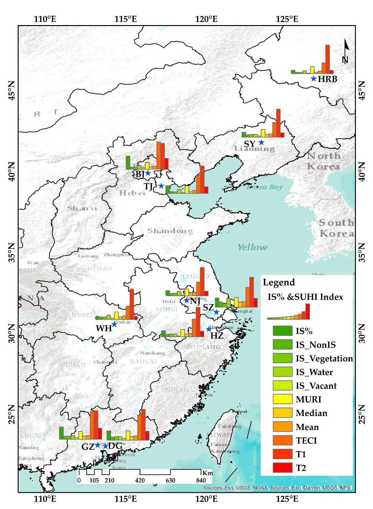
2.1. Study Area Selection
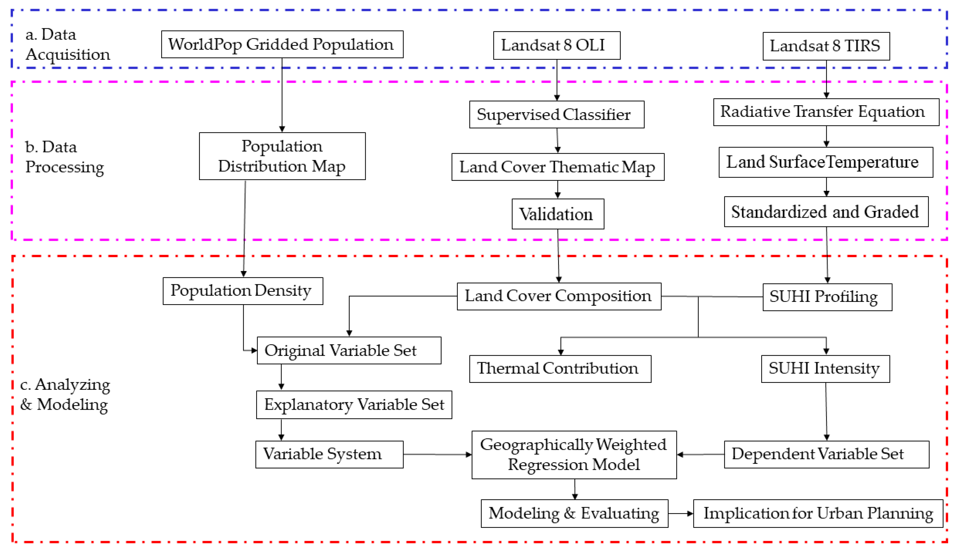
2.2. Data Description and Methodology
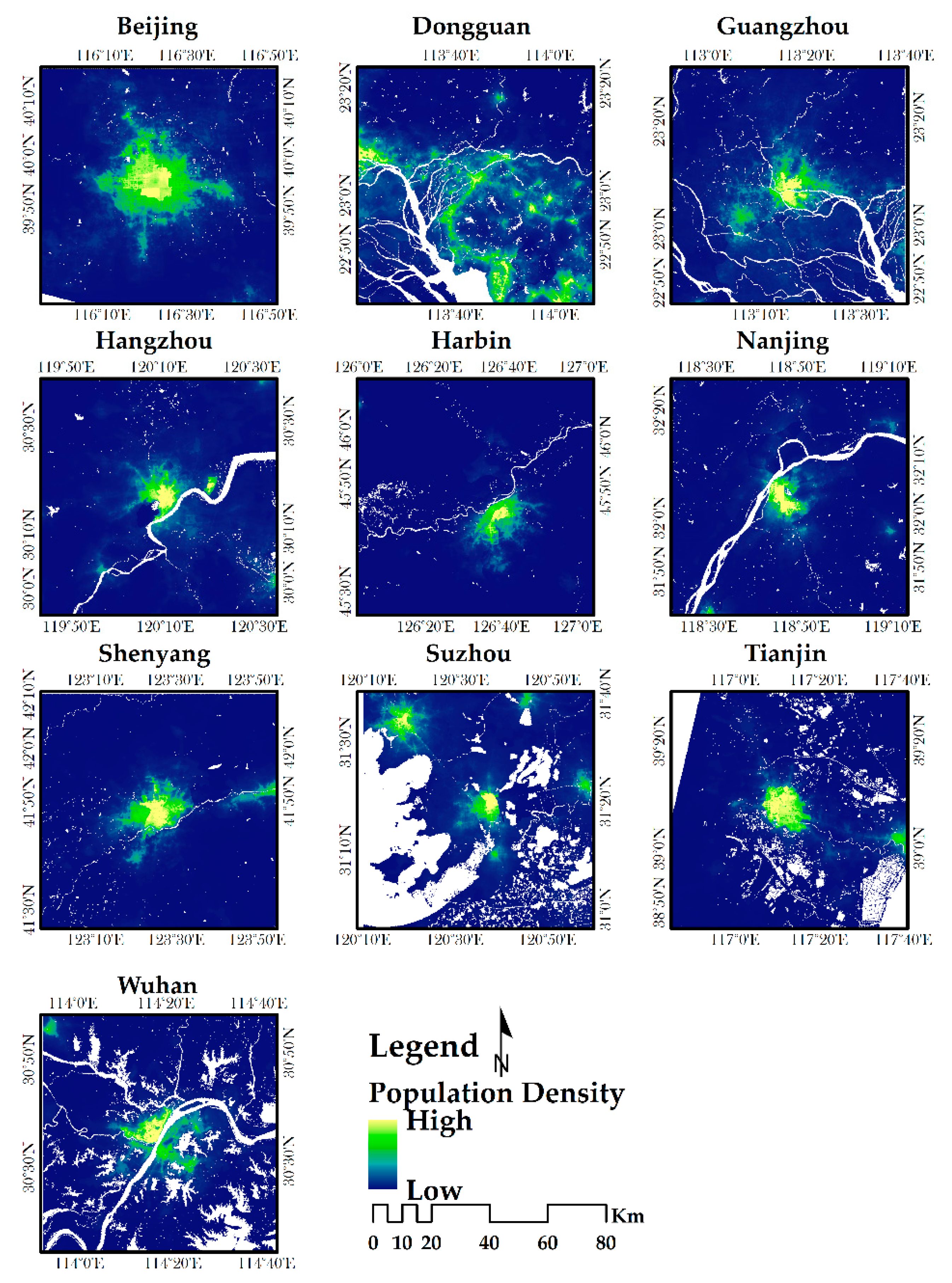
2.2.1. Spatial Distribution of Population
2.2.2. Land Cover/Use Mapping
2.2.3. Land Surface Temperature (LST) Retrieval
2.2.4. Thermal Environment Mapping
2.2.5. SUHII and MURI
2.2.6. The Thermal Effect Contribution of Land Cover
2.2.7. Spatial Determinants and GWR Analysis
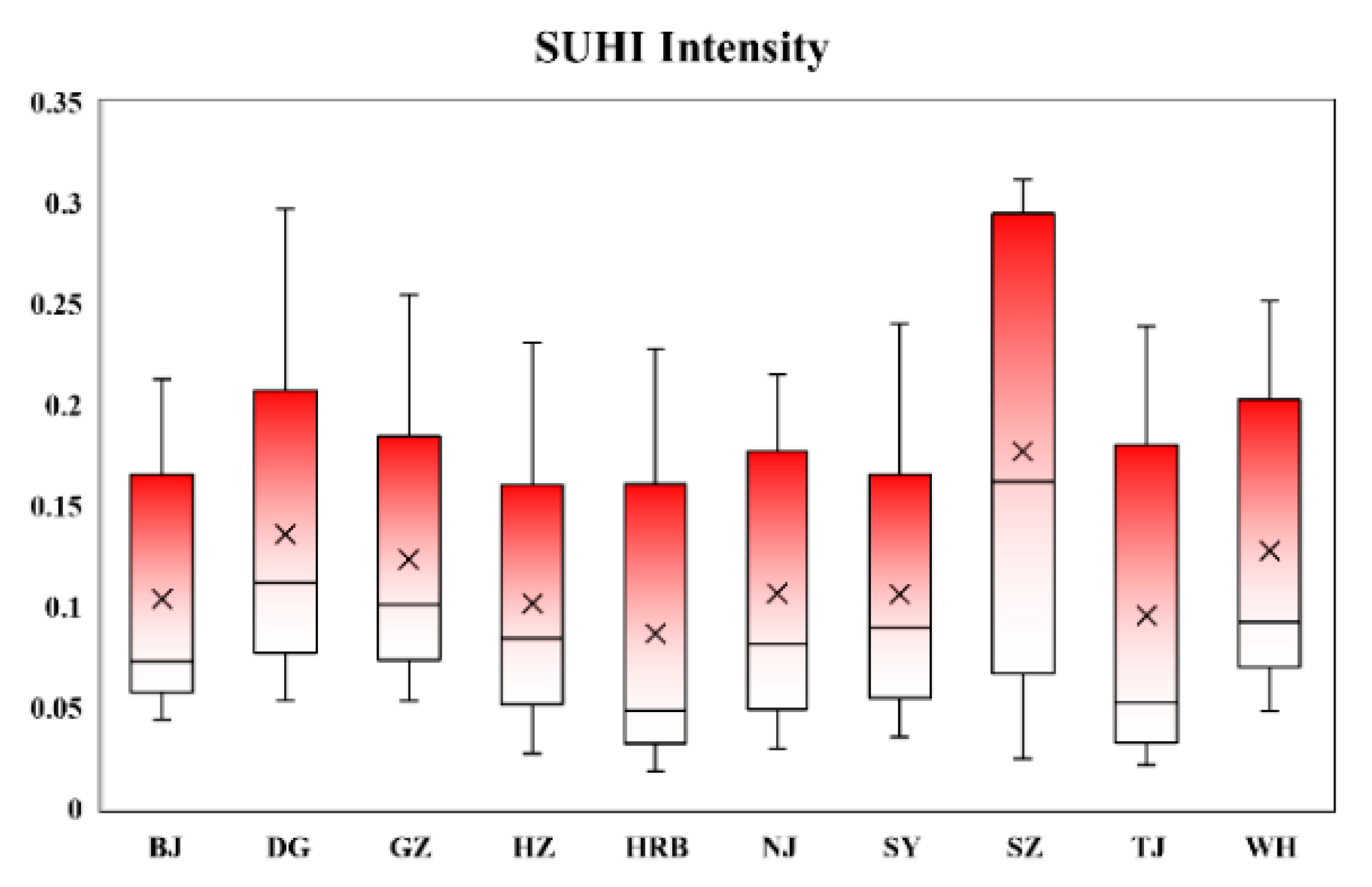
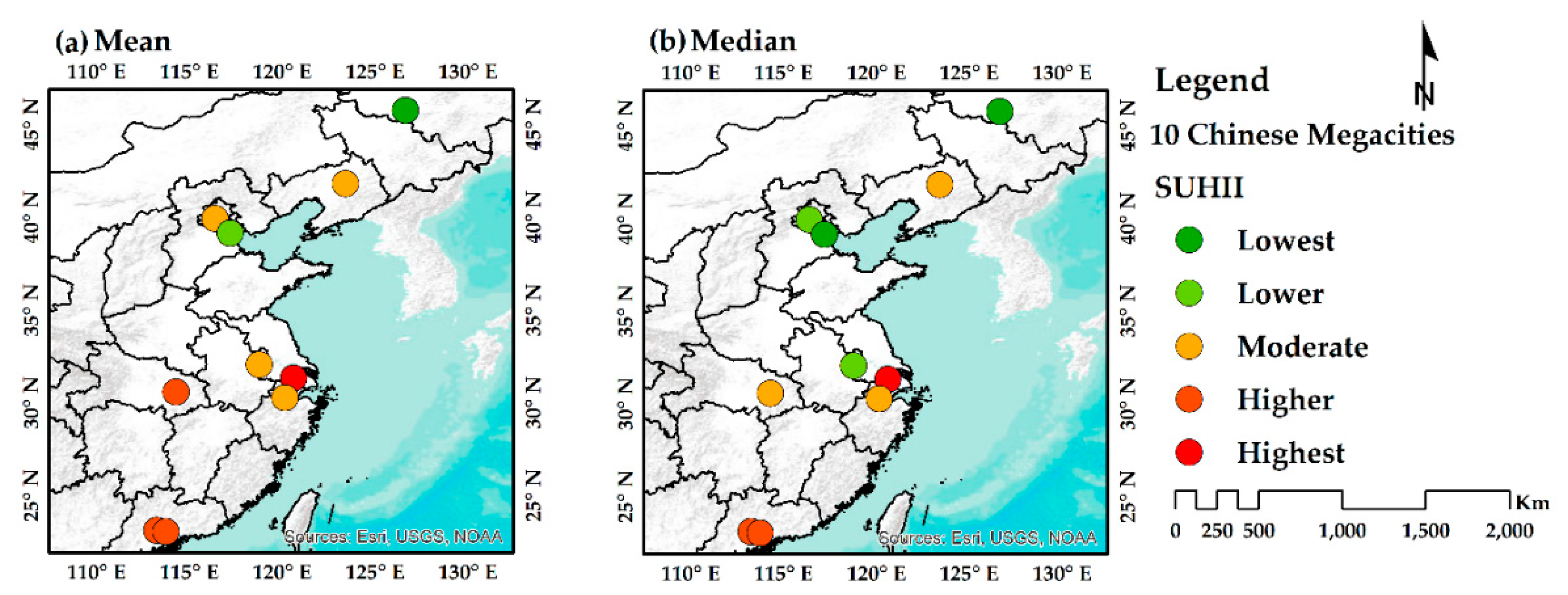
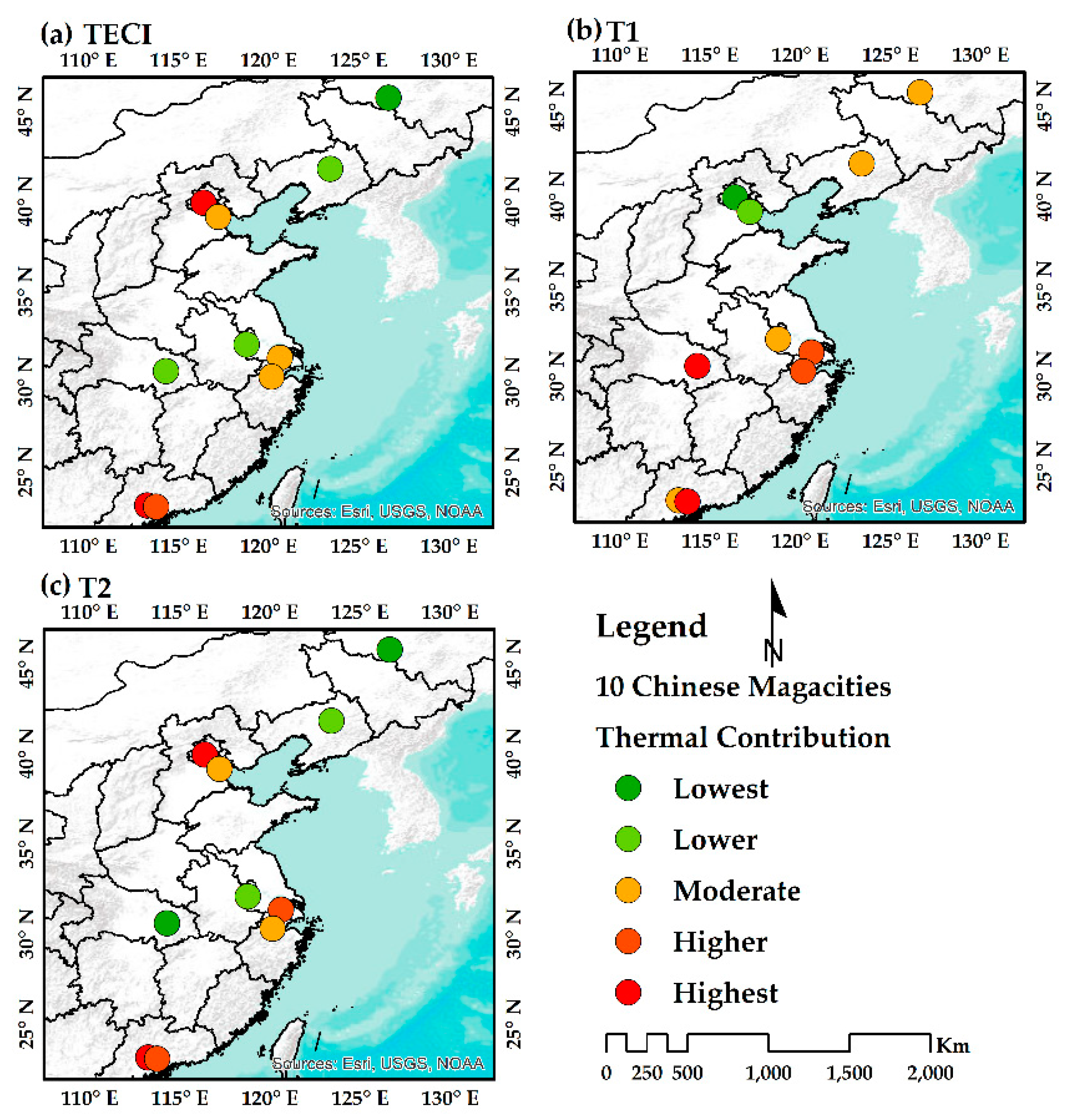
3. Results
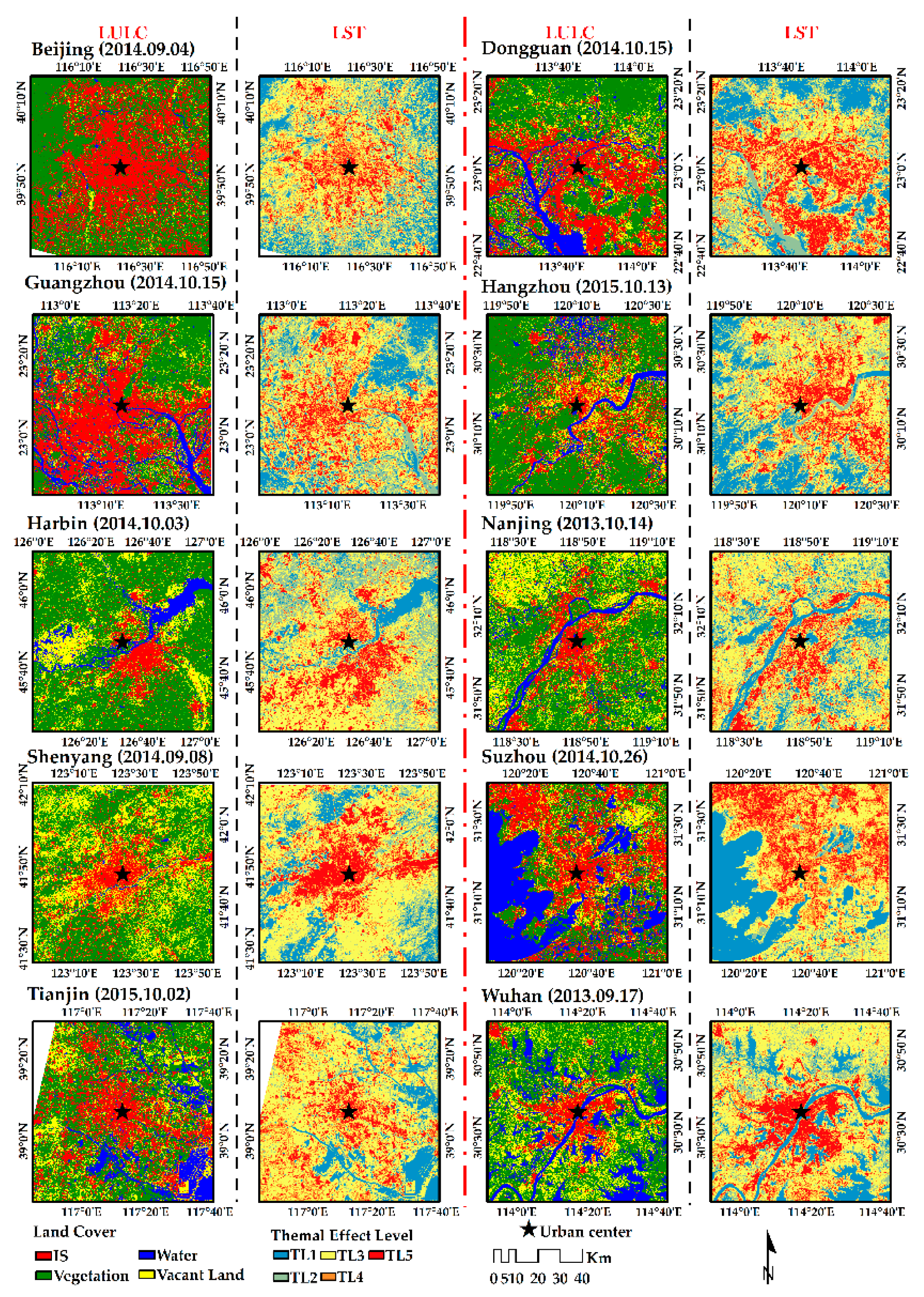
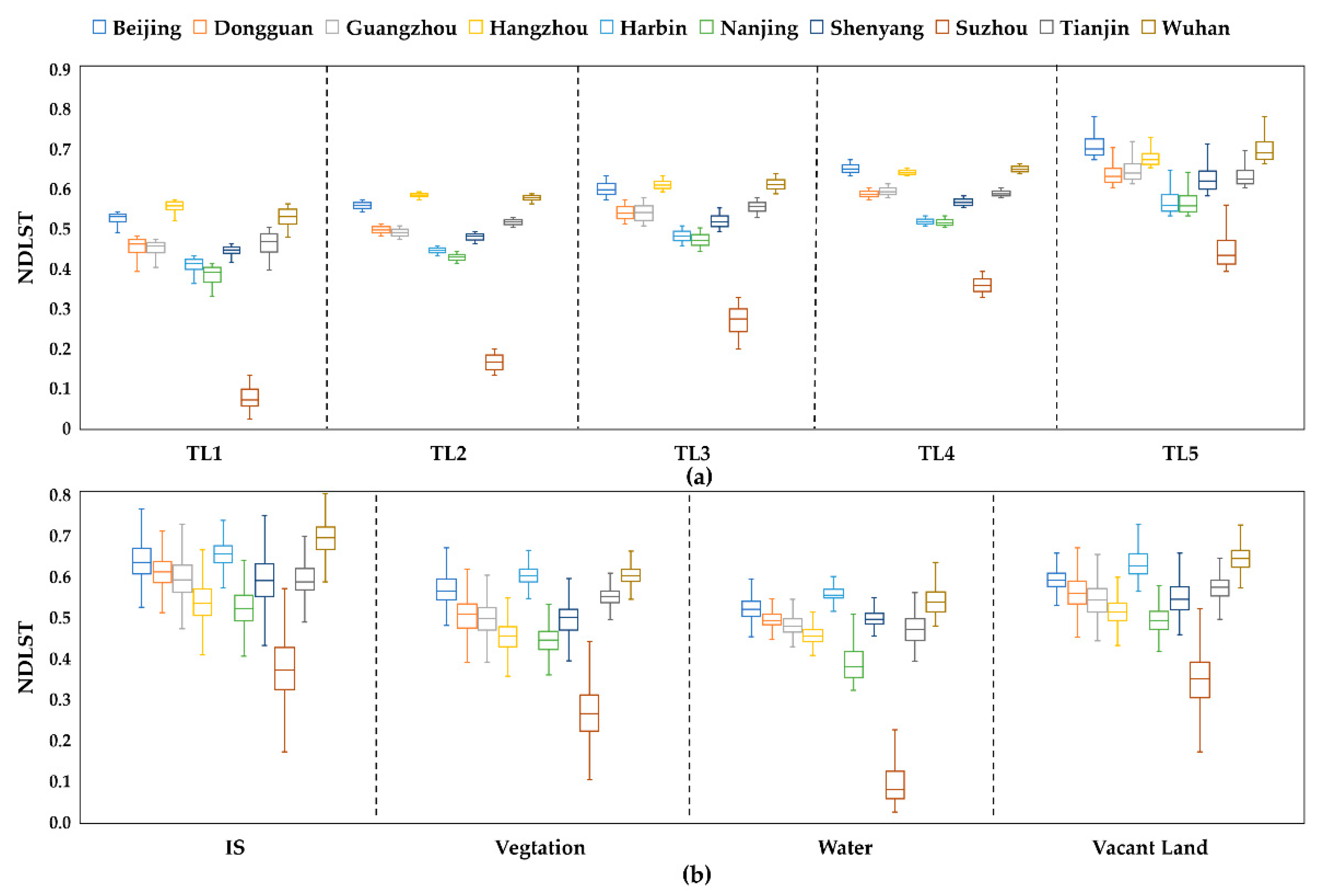
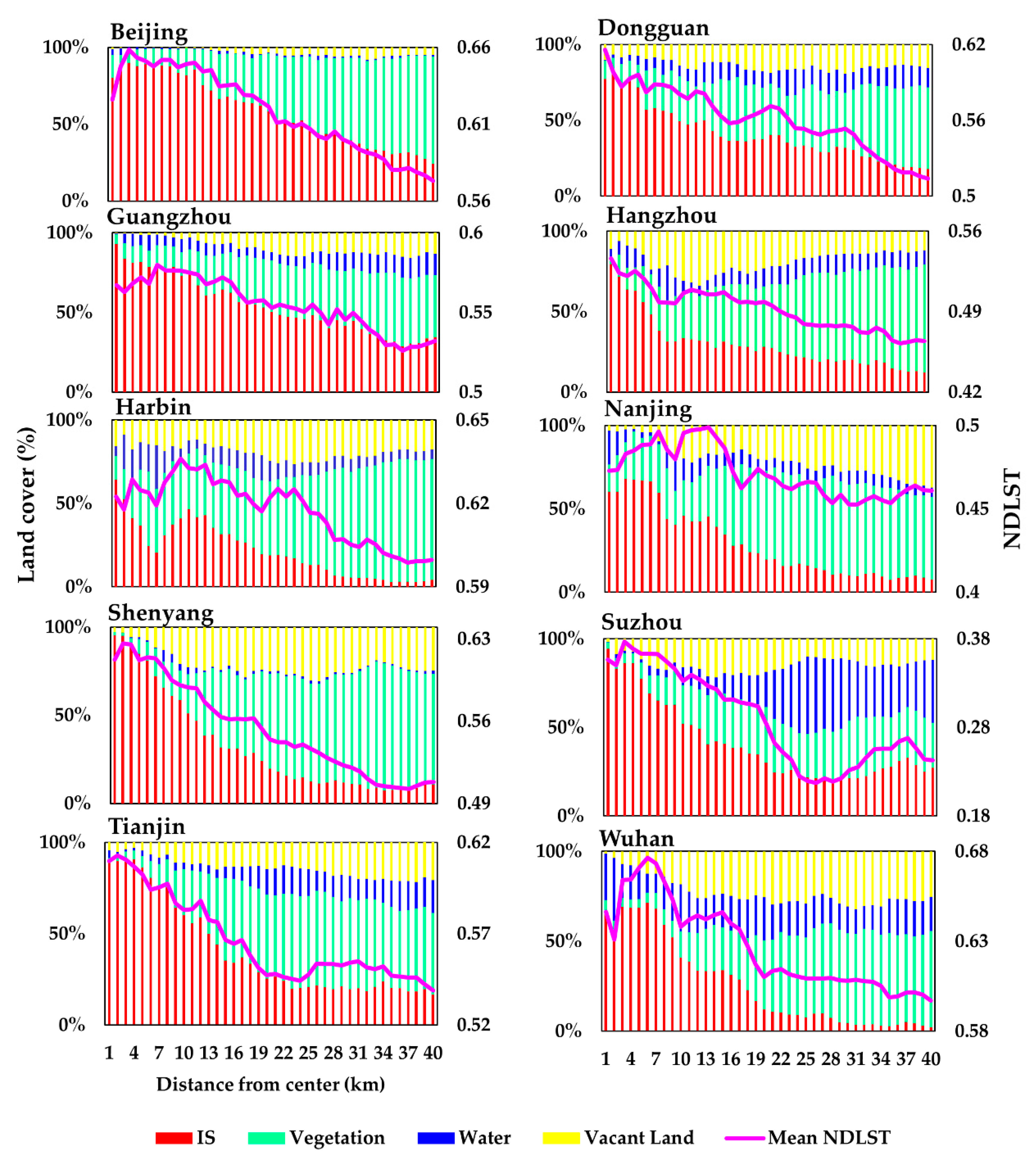
3.1. Spatial Distributions and Characteristics of LST and Land Cover
3.2. Diagnostics of OLS and GWR
4. Discussion
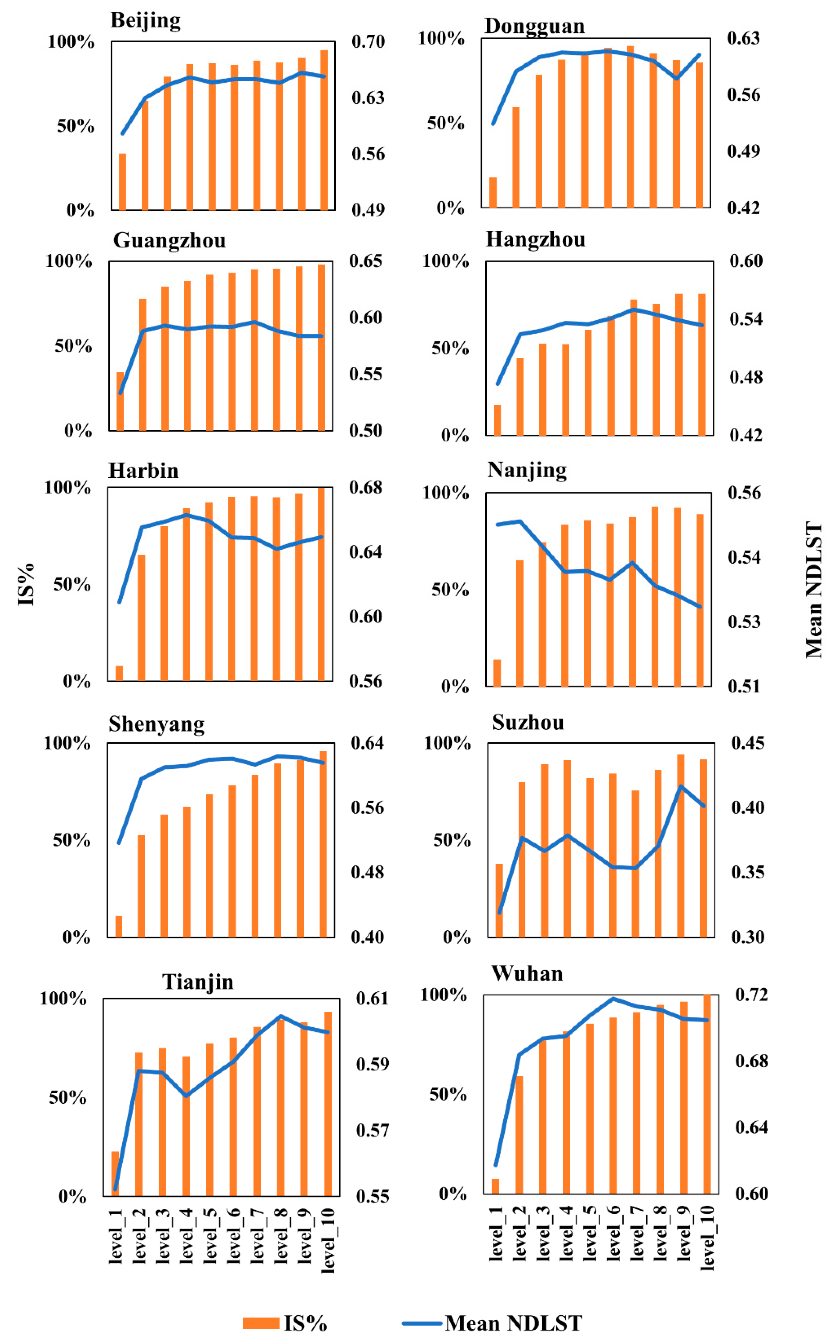
4.1. Responses of Land Cover to UHI: The Similarities and Differences Among Cities
4.2. Linkages among LCC, Population, and UHI: Thermal Effects in Densely Populated Chinese Megacities
4.3. Implications for UHI Mitigation and Further Suggestions for Urban Sustainability
5. Conclusions
Author Contributions
Funding
Acknowledgments
Conflicts of Interest
Appendix A

| City | Overall Accuracy (%) | Kappa Coefficient | Producer’s Accuracy (%) | Producer’s Accuracy (%) | ||||||
|---|---|---|---|---|---|---|---|---|---|---|
| IS | Vegetation | Water | Vacant Land | IS | Vegetation | Water | Vacant Land | |||
| Beijing | 96 | 0.9467 | 97.94 | 96 | 97.96 | 92.38 | 94.06 | 96 | 96 | 97.98 |
| Dongguan | 93.25 | 0.91 | 85.98 | 97.06 | 98.02 | 92.22 | 92 | 99 | 99 | 83 |
| Guangzhou | 94.5 | 0.9267 | 90.74 | 98 | 95.15 | 94.38 | 96.08 | 98.99 | 98.99 | 84 |
| Hangzhou | 90 | 0.8666 | 80.53 | 95.15 | 96.91 | 88.51 | 91.92 | 94.23 | 94 | 79.38 |
| Harbin | 94.75 | 0.93 | 94.12 | 98.96 | 98.87 | 87.62 | 95.05 | 95 | 96 | 92.93 |
| Nanjing | 90.75 | 0.8766 | 88.89 | 96.59 | 95.15 | 83.64 | 89.8 | 85 | 98 | 90.2 |
| Shenyang | 91.25 | 0.8833 | 90 | 93.75 | 94.12 | 87.25 | 90.91 | 90 | 96 | 88.12 |
| Suzhou | 91.5 | 0.8867 | 87.27 | 95.79 | 87.72 | 97.53 | 96 | 91.92 | 100 | 78.22 |
| Tianjin | 89.5 | 0.86 | 83.65 | 95.92 | 92.33 | 86.32 | 87.88 | 94 | 95 | 81.19 |
| Wuhan | 90.75 | 0.8767 | 84.55 | 92.93 | 91.74 | 95.12 | 93 | 92 | 100 | 78 |
| City | Band Average Atmospheric Transmission | Effective Bandpass Upwelling Radiance (W/m2 · sr · μm) | Effective Bandpass Downwelling Radiance (W/m2 · sr · μm) |
|---|---|---|---|
| Beijing | 0.93 | 0.43 | 0.77 |
| Dongguan | 0.74 | 2.02 | 3.27 |
| Guangzhou | 0.74 | 2.02 | 3.27 |
| Hangzhou | 0.91 | 0.68 | 1.18 |
| Harbin | 0.94 | 0.35 | 0.63 |
| Nanjing | 0.78 | 1.88 | 3.03 |
| Shenyang | 0.88 | 0.9 | 1.53 |
| Suzhou | 0.78 | 1.81 | 2.96 |
| Tianjin | 0.91 | 0.67 | 1.17 |
| Wuhan | 0.68 | 2.84 | 4.5 |

References
- United Nations, Department of Economic and Social Affairs, Population Division, (UN DESA). World Population Prospects: The 2015 Revision; UN DESA: New York, NY, USA, 2015. [Google Scholar]
- Oke, T.R. The energetic basis of the urban heat island. Q. J. R. Meteorol. Soc. 1982, 108, 1–24. [Google Scholar] [CrossRef]
- Gago, E.J.; Roldan, J.; Pacheco-Torres, R.; Ordóñez, J. The city and urban heat islands: A review of strategies to mitigate adverse effects. Renew. Sustain. Energy Rev. 2013, 25, 749–758. [Google Scholar] [CrossRef]
- Deilami, K.; Kamruzzaman, M.; Liu, Y. Urban heat island effect: A systematic review of spatio-temporal factors, data, methods, and mitigation measures. Int. J. Appl. Earth Obs. Geoinf. 2018, 67, 30–42. [Google Scholar] [CrossRef]
- United Nations Development Programme (UNDP). Sustainable Urbanization Strategy; UNDP: New York, NY, USA, 2016. [Google Scholar]
- Gupta, J.; Vegelin, C. Sustainable development goals and inclusive development. Int. Environ. Agreem. Polit. Law Econ. 2016, 16, 433–448. [Google Scholar] [CrossRef]
- United Nations (UN).Transforming Our World: The 2030 Agenda for Sustainable Development. General Assembley 70 Session. 2015. Available online: https://sustainabledevelopment.un.org/post2015/transformingourworld (accessed on 27 August 2019).
- National Bureau of Statistics (NBS) of China. Available online: http://www.stats.gov.cn/english/ (accessed on 3 July 2019).
- Kuang, W.; Liu, J.; Zhang, Z.; Lu, D.; Xiang, B. Spatiotemporal dynamics of impervious surface areas across China during the early 21st century. Chin. Sci. Bull. 2013, 58, 1691–1701. [Google Scholar] [CrossRef]
- Liu, J.; Kuang, W.; Zhang, Z.; Xu, X.; Qin, Y.; Ning, J.; Zhou, W.; Zhang, S.; Li, R.; Yan, C.; et al. Spatiotemporal characteristics, patterns and causes of land use changes in China since the late 1980s. J. Geogr. Sci. 2014, 24, 195–210. [Google Scholar] [CrossRef]
- Xiong, Y.; Huang, S.; Chen, F.; Ye, H.; Wang, C.; Zhu, C. The impacts of rapid urbanization on the thermal environment: A remote sensing study of Guangzhou, South China. Remote Sens. 2012, 4, 2033–2056. [Google Scholar] [CrossRef]
- Zhou, D.; Bonafoni, S.; Zhang, L.; Wang, R. Remote sensing of the urban heat island effect in a highly populated urban agglomeration area in East China. Sci. Total Environ. 2018, 628, 415–429. [Google Scholar] [CrossRef]
- Liu, J.; Deng, X. Impacts and mitigation of climate change on Chinese cities. Curr. Opin. Environ. Sustain. 2011, 3, 188–192. [Google Scholar] [CrossRef]
- Peng, J.; Ma, J.; Liu, Q.; Liu, Y.; Hu, Y.; Li, Y.; Yue, Y. Spatial-temporal change of land surface temperature across 285 cities in China: An urban-rural contrast perspective. Sci. Total Environ. 2018, 635, 487–497. [Google Scholar] [CrossRef]
- Wang, J.; Huang, B.; Fu, D.; Atkinson, P.M. Spatiotemporal variation in surface urban heat island intensity and associated determinants across major Chinese cities. Remote Sens. 2015, 7, 3670–3689. [Google Scholar] [CrossRef]
- Yao, R.; Wang, L.; Huang, X.; Niu, Z.; Liu, F.; Wang, Q. Temporal trends of surface urban heat islands and associated determinants in major Chinese cities. Sci. Total Environ. 2017, 609, 742–754. [Google Scholar] [CrossRef] [PubMed]
- Zhou, D.; Zhao, S.; Liu, S.; Zhang, L.; Zhu, C. Surface urban heat island in China’s 32 major cities: Spatial patterns and drivers. Remote Sens. Environ. 2014, 152, 51–61. [Google Scholar] [CrossRef]
- Zhou, D.; Zhao, S.; Zhang, L.; Sun, G.; Liu, Y. The footprint of urban heat island effect in China. Sci. Rep. 2015, 5, 2–12. [Google Scholar] [CrossRef] [PubMed]
- Zhang, J.; Dong, W.; Wu, L.; Wei, J.; Chen, P.; Lee, D. Impact of land use changes on surface warming in China. Adv. Atmos. Sci. 2005, 22, 343–348. [Google Scholar]
- Zhou, D.; Xiao, J.; Bonafoni, S.; Berger, C.; Deilami, K.; Zhou, Y.; Frolking, S.; Yao, R.; Qiao, Z.; Sobrino, J.A. Satellite remote sensing of surface urban heat islands: Progress, challenges, and perspectives. Remote Sens. 2019, 11, 48. [Google Scholar] [CrossRef]
- Huang, Y.; Yuan, M.; Lu, Y. Spatially varying relationships between surface urban heat islands and driving factors across cities in China. Environ. Plan. B Urban Anal. City Sci. 2019, 46, 377–394. [Google Scholar] [CrossRef]
- Li, K.; Chen, Y.; Wang, M.; Gong, A. Spatial-temporal variations of surface urban heat island intensity induced by different definitions of rural extents in China. Sci. Total Environ. 2019, 669, 229–247. [Google Scholar] [CrossRef]
- Tran, D.X.; Pla, F.; Latorre-Carmona, P.; Myint, S.W.; Caetano, M.; Kieu, H.V. Characterizing the relationship between land use land cover change and land surface temperature. ISPRS J. Photogramm. Remote Sens. 2017, 124, 119–132. [Google Scholar] [CrossRef]
- Yao, R.; Wang, L.; Huang, X.; Zhang, W.; Li, J.; Niu, Z. Interannual variations in surface urban heat island intensity and associated drivers in China. J. Environ. Manag. 2018, 222, 86–94. [Google Scholar] [CrossRef]
- Chen, W.; Zhang, Y.; Pengwang, C.; Gao, W. Evaluation of urbanization dynamics and its impacts on surface heat islands: A case study of Beijing, China. Remote Sens. 2017, 9, 453. [Google Scholar] [CrossRef]
- Li, X.; Zhou, W.; Ouyang, Z.; Xu, W.; Zheng, H. Spatial pattern of greenspace affects land surface temperature: Evidence from the heavily urbanized Beijing metropolitan area, China. Landsc. Ecol. 2012, 27, 887–898. [Google Scholar] [CrossRef]
- Xu, D.; Chen, R. Comparison of urban heat island and urban reflection in Nanjing City of China. Sustain. Cities Soc. 2017, 31, 26–36. [Google Scholar] [CrossRef]
- Li, L.; Tan, Y.; Ying, S.; Yu, Z.; Li, Z.; Lan, H. Impact of land cover and population density on land surface temperature: Case study in Wuhan, China. J. Appl. Remote Sens. 2014, 8, 084993. [Google Scholar] [CrossRef]
- Zhang, X.; Estoque, R.C.; Murayama, Y. An urban heat island study in Nanchang City, China based on land surface temperature and social-ecological variables. Sustain. Cities Soc. 2017, 32, 557–568. [Google Scholar] [CrossRef]
- Zhang, H.; Qi, Z.; Ye, X.; Cai, Y.; Ma, W.; Chen, M. Analysis of land use/land cover change, population shift, and their effects on spatiotemporal patterns of urban heat islands in metropolitan Shanghai, China. Appl. Geogr. 2013, 44, 121–133. [Google Scholar] [CrossRef]
- Deilami, K.; Kamruzzaman, M.; Hayes, J.F. Correlation or causality between land cover patterns and the urban heat island effect? Evidence from Brisbane, Australia. Remote Sens. 2016, 8, 716. [Google Scholar] [CrossRef]
- Zhao, C.; Jensen, J.; Weng, Q.; Weaver, R. A geographically weighted regression analysis of the underlying factors related to the surface urban heat island phenomenon. Remote Sens. 2018, 10, 1428. [Google Scholar] [CrossRef]
- Luo, X.; Peng, Y. Scale effects of the relationships between urban heat islands and impact factors based on a geographically-weighted regression model. Remote Sens. 2016, 8, 760. [Google Scholar] [CrossRef]
- Li, W.; Cao, Q.; Lang, K.; Wu, J. Linking potential heat source and sink to urban heat island: Heterogeneous effects of landscape pattern on land surface temperature. Sci. Total Environ. 2017, 586, 457–465. [Google Scholar] [CrossRef]
- Li, F.; Sun, W.; Yang, G.; Weng, Q. Investigating spatiotemporal patterns of surface urban heat islands in the Hangzhou Metropolitan Area, China, 2000–2015. Remote Sens. 2019, 11, 1553. [Google Scholar] [CrossRef]
- Naughton, B.J. The Chinese Economy: Transitions and Growth; MIT Press: Cambridge, MA, USA, 2006. [Google Scholar]
- Zhang, J.; Wu, L. Modulation of the urban heat island by the tourism during the Chinese New Year holiday: A case study in Sanya City, Hainan Province of China. Sci. Bull. 2015, 60, 1543–1546. [Google Scholar] [CrossRef]
- Zhang, X.; Wang, D.; Hao, H.; Zhang, F.; Hu, Y. Effects of land use/cover changes and urban forest configuration on urban heat islands in a loess hilly region: Case study based on Yan’an City, China. Int. J. Environ. Res. Public Health 2017, 14, 840. [Google Scholar] [CrossRef]
- Zhao, X.; Huang, J.; Ye, H.; Wang, K.; Qiu, Q. Spatiotemporal changes of the urban heat island of a coastal city in the context of urbanisation. Int. J. Sustain. Dev. World Ecol. 2010, 17, 311–316. [Google Scholar] [CrossRef]
- The National Development and Reform Comimission (NDRC). China’s National Climate Change Program (June 2007). Available online: http://www.china-un.org/eng/gyzg/t626117.htm (accessed on 20 September 2019).
- Williams, L. China’s Climate Change Policies: Actors and Drivers. Sydney: Lowy Institute for International Policy. 2014. Available online: https://www.lowyinstitute.org/publications/chinas-climate-change-policies-actors-and-drivers (accessed on 20 September 2019).
- Du, H.; Wang, D.; Wang, Y.; Zhao, X.; Qin, F.; Jiang, H.; Cai, Y. Influences of land cover types, meteorological conditions, anthropogenic heat and urban area on surface urban heat island in the Yangtze River Delta Urban Agglomeration. Sci. Total Environ. 2016, 571, 461–470. [Google Scholar] [CrossRef] [PubMed]
- Liu, F.; Murayama, Y. Landsat evaluation of land cover composition and its impacts on urban thermal environment: A case study on the fast-growing Shanghai Metropolitan Area from 2000 to 2015. Geoinfor Geostat Overv. 2018, S3, 2. [Google Scholar]
- Wentz, E.A.; York, A.M.; Alberti, M.; Conrow, L.; Fischer, H.; Inostroza, L.; Jantz, C.; Pickett, S.T.A.; Seto, K.C.; Taubenböck, H. Six fundamental aspects for conceptualizing multidimensional urban form: A spatial mapping perspective. Landsc. Urban Plan. 2018, 179, 55–62. [Google Scholar] [CrossRef]
- Lloyd, C.T.; Sorichetta, A.; Tatem, A.J. High resolution global gridded data for use in population studies. Sci. Data 2017, 4, 170001. [Google Scholar] [CrossRef]
- Stevens, F.R.; Gaughan, A.E.; Linard, C.; Tatem, A.J. Disaggregating census data for population mapping using random forests with remotely-sensed and ancillary data. PLoS ONE 2015, 10, 0107042. [Google Scholar] [CrossRef]
- Tatem, A.J. WorldPop, open data for spatial demography. Sci. Data 2017, 4, 2–5. [Google Scholar] [CrossRef]
- Phiri, D.; Morgenroth, J. Developments in Landsat land cover classification methods: A review. Remote Sens. 2017, 9, 967. [Google Scholar] [CrossRef]
- Lu, D.; Weng, Q. A survey of image classification methods and techniques for improving classification performance. Int. J. Remote Sens. 2007, 28, 823–870. [Google Scholar] [CrossRef]
- Zhou, W.; Qian, Y.; Li, X.; Li, W.; Han, L. Relationships between land cover and the surface urban heat island: Seasonal variability and effects of spatial and thematic resolution of land cover data on predicting land surface temperatures. Landsc. Ecol. 2014, 29, 153–167. [Google Scholar] [CrossRef]
- Laben, C.A.; Brower, B.V. Process for Enhancing the Spatial Resolution of Multispectral Imagery Using Pan-Sharpening. U.S. Patent No. 6,011,875, 4 January 2000. [Google Scholar]
- Yuhendra; Joshapat, T.S.; Hiroaki, K. Performance analyzing of high resolution pan-sharpening techniques: Increasing image quality for classification using supervised kernel support vector machine. Res. J. Inf. Technol. 2011, 3, 12–23. [Google Scholar]
- Anderson, J.R. A Land Use and Land Cover Classification System for Use with Remote Sensor Data; US Government Printing Office: Washington, DC, USA, 1976; Volume 964.
- Janssen, L.L.F.; van der Wel, F.J.M. Accuracy assessment of satellite derived land-cover data: A review. Photogramm. Eng. Remote Sens. 1994, 60, 419–426. [Google Scholar]
- Galve, J.M.; Sánchez, J.M.; Coll, C.; Villodre, J. A new single-band pixel-by-pixel atmospheric correction method to improve the accuracy in remote sensing estimates of LST. application to Landsat 7-ETM+. Remote Sens. 2018, 10, 826. [Google Scholar] [CrossRef]
- Jin, M.S.; Kessomkiat, W.; Pereira, G. Satellite-observed urbanization characters in Shanghai, China: Aerosols, urban heat island effect, and land-atmosphere interactions. Remote Sens. 2011, 3, 83–99. [Google Scholar] [CrossRef]
- Liang, S.; Fang, H.; Chen, M. Atmospheric correction of Landsat ETM+ land surface imagery—Part I: Methods. IEEE Trans. Geosci. Remote Sens. 2001, 39, 2490–2498. [Google Scholar] [CrossRef]
- McCarville, D.; Buenemann, M.; Bleiweiss, M.; Barsi, J. Atmospheric correction of Landsat thermal infrared data: A calculator based on North American Regional Reanalysis (NARR) data. In Proceedings of the American Society for Photogrammetry and Remote Sensing Conference, Milwaukee, WI, USA, 1–5 May 2011; Volume 15. [Google Scholar]
- Tardy, B.; Rivalland, V.; Huc, M.; Hagolle, O.; Marcq, S.; Boulet, G. A software tool for atmospheric correction and surface temperature estimation of Landsat infrared thermal data. Remote Sens. 2016, 8, 696. [Google Scholar] [CrossRef]
- Barsi, J.A.; Schott, J.R.; Palluconi, F.D.; Hook, S.J. Validation of a web-based atmospheric correction tool for single thermal band instruments. Earth Obs. Syst. X 2005, 5882, 58820E. [Google Scholar]
- Barsi, A.J.; Barker, L.J.; Schott, R.J. An atmospheric correction parameter calculator for a single thermal band earth-sensing instrument. In Proceedings of the 2003 IEEE International Geoscience and Remote Sensing Symposium (IEEE Cat. No. 03CH37477), IGARSS, Toulouse, France, 21–25 July 2003; Volume 5, pp. 3014–3016. [Google Scholar]
- Chen, L.; Jiang, R.; Xiang, W.N. Surface heat island in Shanghai and its relationship with urban development from 1989 to 2013. Adv. Meteorol. 2016, 2016, 9782686. [Google Scholar] [CrossRef]
- Li, Z.; Duan, S.; Tang, B.; Wu, H.; Ren, H.; Yan, G.; Tang, R.; Leng, P. Review of methods for land surface temperature derived from thermal infrared remotely sensed data. J. Remote Sens. 2016, 20, 899–920. (In Chinese) [Google Scholar]
- Shi, T.; Huang, Y.; Wang, H.; Shi, C.E.; Yang, Y.J. Influence of urbanization on the thermal environment of meteorological station: Satellite-observed evidence. Adv. Clim. Chang. Res. 2015, 6, 7–15. [Google Scholar] [CrossRef]
- Ahn, S.; Fessler, J.A. Standard Errors of Mean, Variance, and Standard Deviation Estimators. EECS Dep. Univ. Mich. 2003. Available online: https://web.eecs.umich.edu/~fessler/papers/lists/files/tr/stderr.pdf (accessed on 10 October 2019).
- Sun, Q.; Tan, J.; Xu, Y. An ERDAS image processing method for retrieving LST and describing urban heat evolution: A case study in the Pearl River Delta Region in South China. Environ. Earth Sci. 2009, 59, 1047–1055. [Google Scholar] [CrossRef]
- Estoque, R.C.; Murayama, Y. Intensity and spatial pattern of urban land changes in the megacities of Southeast Asia. Land Use Policy 2015, 48, 213–222. [Google Scholar] [CrossRef]
- Dissanayake, D.M.S.L.B.; Morimoto, T.; Murayama, Y.; Ranagalage, M. Impact of landscape structure on the variation of land surface temperature in Sub-Saharan Region: A case study of Addis Ababa using Landsat Data (1986–2016). Sustainability 2019, 11, 2257. [Google Scholar] [CrossRef]
- Dissanayake, D.; Morimoto, T.; Murayama, Y.; Ranagalage, M.; Handayani, H.H. Impact of urban surface characteristics and socio-economic variables on the spatial variation of land surface temperature in Lagos City, Nigeria. Sustainability 2018, 11, 25. [Google Scholar] [CrossRef]
- De Faria Peres, L.; de Lucena, A.J.; Rotunno Filho, O.C.; de Almeida França, J.R. The urban heat island in Rio de Janeiro, Brazil, in the last 30 years using remote sensing data. Int. J. Appl. Earth Obs. Geoinf. 2018, 64, 104–116. [Google Scholar] [CrossRef]
- Xu, H.Q.; Chen, B.Q. Remote sensing of the urban heat island and its changes in Xiamen City of SE China. J. Environ. Sci. 2004, 16, 276–281. [Google Scholar]
- Xiao, H.; Kopecká, M.; Guo, S.; Guan, Y.; Cai, D.; Zhang, C.; Zhang, X.; Yao, W. Responses of urban land surface temperature on land cover: A comparative study of Vienna and Madrid. Sustainability 2018, 10, 260. [Google Scholar] [CrossRef]
- Simwanda, M.; Ranagalage, M.; Estoque, R.C.; Murayama, Y. Spatial analysis of surface urban heat islands in four rapidly growing African cities. Remote Sens. 2019, 11, 1645. [Google Scholar] [CrossRef]
- Liu, Y.; Kuang, Y.; Wu, Z. Impact of land use on urban land surface temperature: A case study of Dongguan, Guangdong Province. Sci. Geogr. Sin. 2006, 26, 597. (In Chinese) [Google Scholar]
- Lu, D.; Song, K.; Zang, S.; Jia, M.; Du, J.; Ren, C. The effect of urban expansion on urban surface temperature in Shenyang, China: An analysis with Landsat imagery. Environ. Model. Assess. 2015, 20, 197–210. [Google Scholar] [CrossRef]
- Qian, L.; Ding, S. Pearl River Delta land cover change on surface temperature effects. Acta Geogr. Sin. 2005, 60, 761–770. (In Chinese) [Google Scholar]
- Weng, Q.; Lu, D. A sub-pixel analysis of urbanization effect on land surface temperature and its interplay with impervious surface and vegetation coverage in Indianapolis, United States. Int. J. Appl. Earth Obs. Geoinf. 2008, 10, 68–83. [Google Scholar] [CrossRef]
- Wilks, D.S. Statistical Methods in the Atmospheric Sciences; Academic Press: Cambridge, MA, USA, 2011; Volume 100. [Google Scholar]
- Jenks, G.F. The data model concept in statistical mapping. Int. Yearb. Cartogr. 1967, 7, 186–190. [Google Scholar]
- Tursilowati, L.; Tetuko, J.; Sumantyo, S.; Kuze, H.; Adiningsih, E.S. Relationship between urban heat island phenomenon and land use/land cover changes in Jakarta—Indonesia. J. Emerg. Trends Eng. Appl. Sci. 2012, 3, 645–653. [Google Scholar]
- Elvidge, C.D.; Safran, J.; Tuttle, B.; Sutton, P.; Cinzano, P.; Pettit, D.; Arvesen, J.; Small, C. Potential for global mapping of development via a nightsat mission. GeoJournal 2007, 69, 45–53. [Google Scholar] [CrossRef]
- Mohajerani, A.; Bakaric, J.; Jeffrey-Bailey, T. The urban heat island effect, its causes, and mitigation, with reference to the thermal properties of asphalt concrete. J. Environ. Manag. 2017, 197, 522–538. [Google Scholar] [CrossRef]
- Taha, H.; Sailor, D.; Municipal, S. High-Albedo Materials for Reducing Building Cooling Energy Use; U.S. Department of Energy: Washington, DC, USA, 1992.
- Razzaghmanesh, M.; Beecham, S.; Salemi, T. The role of green roofs in mitigating Urban Heat Island effects in the metropolitan area of Adelaide, South Australia. Urban For. Urban Green. 2016, 15, 89–102. [Google Scholar] [CrossRef]
- Synnefa, A.; Dandou, A.; Santamouris, M.; Tombrou, M.; Soulakellis, N. On the use of cool materials as a heat island mitigation strategy. J. Appl. Meteorol. Climatol. 2008, 47, 2846–2856. [Google Scholar] [CrossRef]
- Trlica, A.; Hutyra, L.R.; Schaaf, C.L.; Erb, A.; Wang, J.A. Albedo, land cover, and daytime surface temperature variation across an urbanized landscape. Earth’s Futur. 2017, 5, 1084–1101. [Google Scholar] [CrossRef]
- Kong, F.; Yin, H.; James, P.; Hutyra, L.R.; He, H.S. Effects of spatial pattern of greenspace on urban cooling in a large metropolitan area of eastern China. Landsc. Urban Plan. 2014, 128, 35–47. [Google Scholar] [CrossRef]
- Gunawardena, K.R.; Wells, M.J.; Kershaw, T. Utilising green and bluespace to mitigate urban heat island intensity. Sci. Total Environ. 2017, 584–585, 1040–1055. [Google Scholar] [CrossRef] [PubMed]
- Szaras, L. The impact of urban green spaces on climate and air quality in cities. Geogr. Locality Stud. 2014, 2, 326–354. [Google Scholar]
- Montazeri, H.; Toparlar, Y.; Blocken, B.; Hensen, J.L.M. Simulating the cooling effects of water spray systems in urban landscapes: A computational fluid dynamics study in Rotterdam, The Netherlands. Landsc. Urban Plan. 2017, 159, 85–100. [Google Scholar] [CrossRef]
- Hermosilla, T.; Palomar-Vázquez, J.; Balaguer-Beser, Á.; Balsa-Barreiro, J.; Ruiz, L.A. Using street based metrics to characterize urban typologies. Comput. Environ. Urban Syst. 2014, 44, 68–79. [Google Scholar] [CrossRef]
- Chen, Y. Derivation of the functional relations between fractal dimension of and shape indices of urban form. Comput. Environ. Urban Syst. 2011, 35, 442–451. [Google Scholar] [CrossRef]


| City | Acquisition Time | GMT Time | Path | Row | Scene Center Longitude | Scene Center Latitude |
|---|---|---|---|---|---|---|
| Beijing | 10/6/2014 | 2:53 | 123 | 32 | 40°20′N | 116°41′E |
| Dongguan | 10/15/2014 | 2:52 | 122 | 44 | 23°07′N | 113°33′E |
| Guangzhou | 10/15/2014 | 2:52 | 122 | 44 | 23°07′N | 113°33′E |
| Hangzhou | 10/13/2015 | 2:31 | 119 | 39 | 30°18′N | 119°59′E |
| Harbin | 10/3/2014 | 2:21 | 118 | 29 | 46°2′N | 126°22′E |
| Nanjing | 10/14/2013 | 2:39 | 120 | 38 | 31°45′N | 118°49′E |
| Shenyang | 9/8/2014 | 2:28 | 119 | 31 | 41°46′N | 123°19′E |
| Suzhou | 10/26/2014 | 2:31 | 119 | 38 | 31°45′N | 120°22′E |
| Tianjin | 10/2/2015 | 2:47 | 122 | 33 | 38°54′N | 117°47′E |
| Wuhan | 9/17/2013 | 2:58 | 123 | 39 | 30°18′N | 113°48′E |
| Thermal Effect Category (LST Grade) | Criterion/Division |
|---|---|
| Temperature Level Five (TL5) | |
| Temperature Level Four (TL4) | |
| Temperature Level Three (TL3) | |
| Temperature Level Two (TL2) | |
| Temperature Level One (TL1) |
| City | TL4 Zone | TL5 Zone | MURI | ||
|---|---|---|---|---|---|
| Area (km2) | Percentage (%) | Area (km2) | Percentage (%) | ||
| Beijing | 906.14 | 13.97 | 654.38 | 10.09 | 21.26 |
| Dongguan | 792.03 | 12.11 | 1,309.60 | 20.02 | 29.71 |
| Guangzhou | 894.25 | 13.7 | 944.48 | 14.47 | 25.43 |
| Hangzhou | 740.91 | 11.33 | 918.95 | 14.05 | 23.12 |
| Harbin | 734.42 | 11.29 | 895.1 | 13.76 | 22.8 |
| Nanjing | 858.61 | 13.18 | 712.08 | 10.93 | 21.48 |
| Shenyang | 702.29 | 10.84 | 996.43 | 15.37 | 24.04 |
| Suzhou | 1,273.36 | 19.53 | 1,010.86 | 15.51 | 31.14 |
| Tianjin | 961.53 | 15.27 | 733.51 | 11.65 | 23.87 |
| Wuhan | 754.79 | 11.66 | 1,025.79 | 15.85 | 25.17 |
| City | ||||
|---|---|---|---|---|
| Beijing | 0.0711 | 0.0727 | 0.1181 | 0.0438 |
| Dongguan | 0.1003 | 0.1117 | 0.1171 | 0.0537 |
| Guangzhou | 0.0937 | 0.1008 | 0.1149 | 0.0530 |
| Hangzhou | 0.0765 | 0.0891 | 0.0842 | 0.0272 |
| Harbin | 0.0453 | 0.0485 | 0.0937 | 0.0186 |
| Nanjing | 0.0681 | 0.0812 | 0.1395 | 0.0299 |
| Shenyang | 0.0741 | 0.0895 | 0.0905 | 0.0354 |
| Suzhou | 0.1620 | 0.1088 | 0.2783 | 0.0249 |
| Tianjin | 0.0523 | 0.0437 | 0.1217 | 0.0215 |
| Wuhan | 0.0921 | 0.0922 | 0.1535 | 0.0480 |
| City | Global Regression (OLS Model) | Local Regression (GWR Model) | ||||||||
|---|---|---|---|---|---|---|---|---|---|---|
| NMPD Coefficient | LCC% Coefficient | R-Squared | Adjusted R-Squared | Global Moran’s I | NMPD Mean Coefficient | LCC% Mean Coefficient | R-Squared | Adjusted R-Squared | Global Moran’s I | |
| Beijing | 0.163108 | −0.000045 | 0.281929 | 0.28171 | 0.682344 | 1.963894 | −0.003884 | 0.76019 | 0.740372 | 0.283504 |
| Dongguan | 0.347355 | −0.000038 | 0.370344 | 0.370154 | 0.725134 | 1.948306 | −0.00918 | 0.842507 | 0.815936 | 0.221621 |
| Guangzhou | 0.17548 | −0.000087 | 0.170419 | 0.170216 | 0.69623 | 2.694511 | −0.006249 | 0.794933 | 0.760049 | 0.182487 |
| Hangzhou | 0.191984 | −0.000087 | 0.197194 | 0.196949 | 0.72605 | 3.336713 | −0.000641 | 0.818523 | 0.791784 | 0.250749 |
| Harbin | 0.105278 | −0.000009 | 0.105295 | 0.105022 | 0.76075 | 1.588056 | −0.00023 | 0.772503 | 0.729364 | 0.230551 |
| Nanjing | 0.125807 | −0.000031 | 0.067459 | 0.067174 | 0.703049 | 3.002098 | −0.000193 | 0.682146 | 0.63855 | 0.340123 |
| Shenyang | 0.217129 | −0.00004 | 0.275091 | 0.274869 | 0.778626 | 3.382181 | −0.000627 | 0.861593 | 0.829901 | 0.203363 |
| Suzhou | 0.68758 | −0.000076 | 0.093879 | 0.093603 | 0.895756 | 8.588178 | −0.001004 | 0.862382 | 0.855237 | 0.430036 |
| Tianjin | 0.095847 | −0.000006 | 0.074371 | 0.07408 | 0.790775 | 1.898453 | −0.000502 | 0.756358 | 0.730738 | 0.342001 |
| Wuhan | 0.236261 | −0.000007 | 0.203187 | 0.202944 | 0.722517 | 4.561839 | −0.000204 | 0.708955 | 0.678869 | 0.397796 |
© 2020 by the authors. Licensee MDPI, Basel, Switzerland. This article is an open access article distributed under the terms and conditions of the Creative Commons Attribution (CC BY) license (http://creativecommons.org/licenses/by/4.0/).
Share and Cite
Liu, F.; Zhang, X.; Murayama, Y.; Morimoto, T. Impacts of Land Cover/Use on the Urban Thermal Environment: A Comparative Study of 10 Megacities in China. Remote Sens. 2020, 12, 307. https://doi.org/10.3390/rs12020307
Liu F, Zhang X, Murayama Y, Morimoto T. Impacts of Land Cover/Use on the Urban Thermal Environment: A Comparative Study of 10 Megacities in China. Remote Sensing. 2020; 12(2):307. https://doi.org/10.3390/rs12020307
Chicago/Turabian StyleLiu, Fei, Xinmin Zhang, Yuji Murayama, and Takehiro Morimoto. 2020. "Impacts of Land Cover/Use on the Urban Thermal Environment: A Comparative Study of 10 Megacities in China" Remote Sensing 12, no. 2: 307. https://doi.org/10.3390/rs12020307
APA StyleLiu, F., Zhang, X., Murayama, Y., & Morimoto, T. (2020). Impacts of Land Cover/Use on the Urban Thermal Environment: A Comparative Study of 10 Megacities in China. Remote Sensing, 12(2), 307. https://doi.org/10.3390/rs12020307