Present-Day Deformation of the Gyaring Co Fault Zone, Central Qinghai–Tibet Plateau, Determined Using Synthetic Aperture Radar Interferometry


Abstract
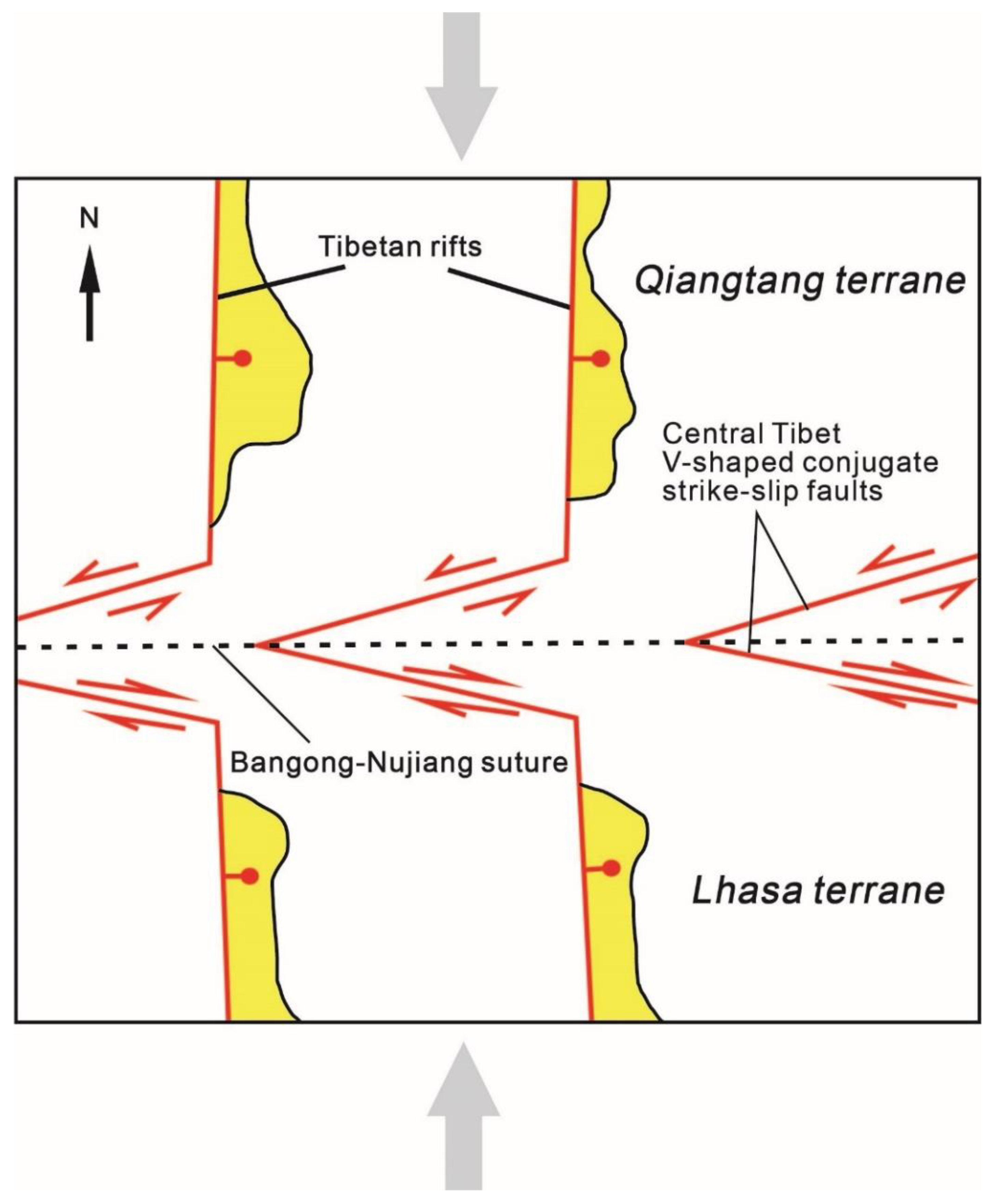
1. Introduction
2. Interferometric Synthetic Aperture Radar (InSAR) Observations
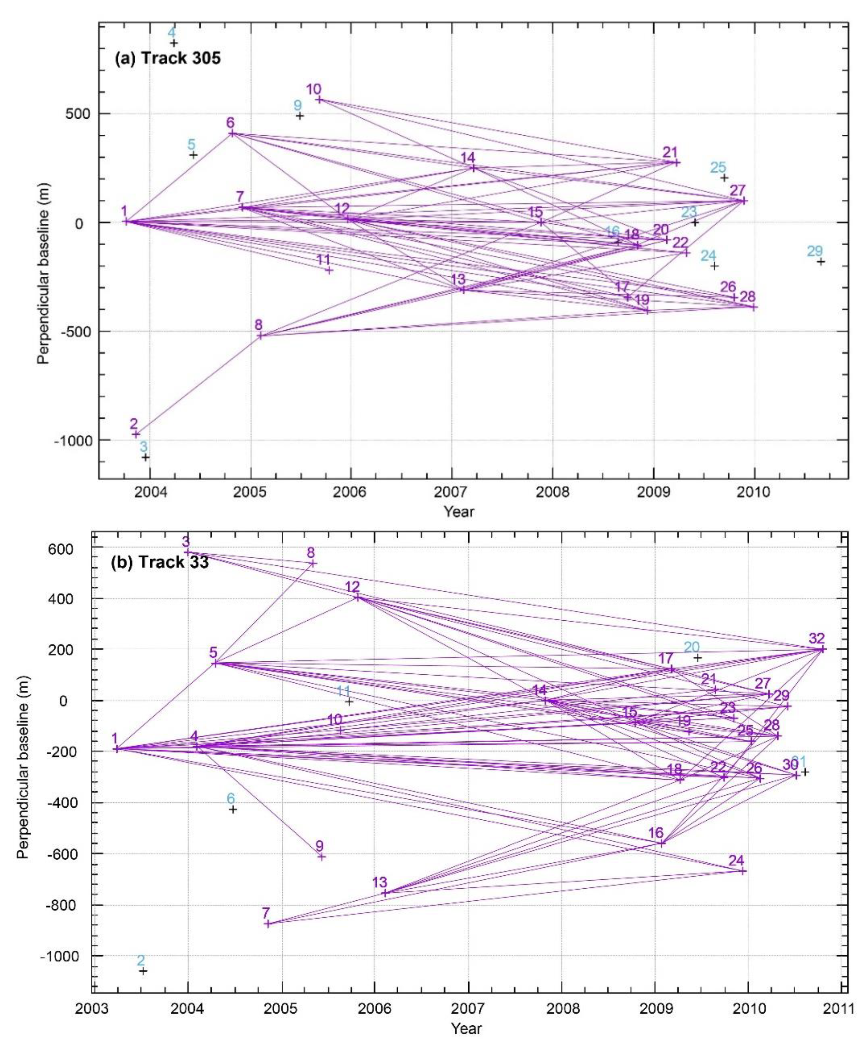
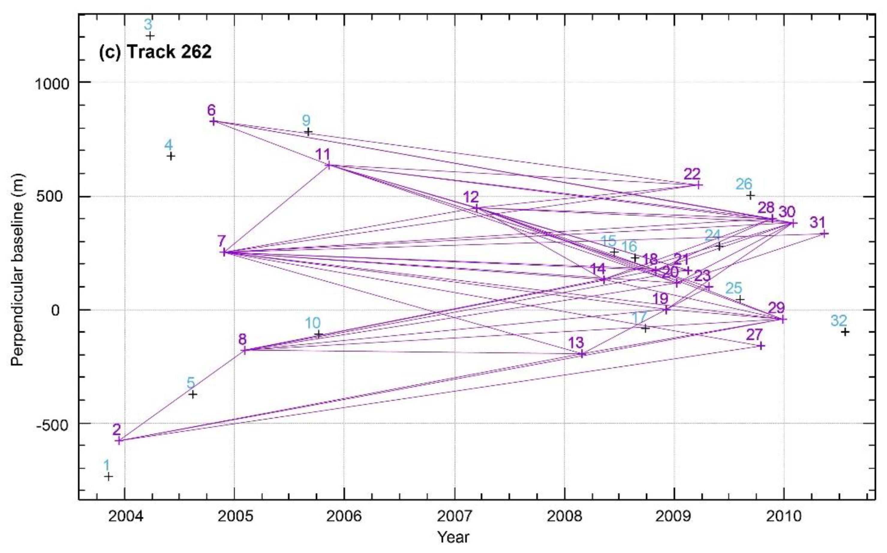
2.1. SAR Images and InSAR Data Processing
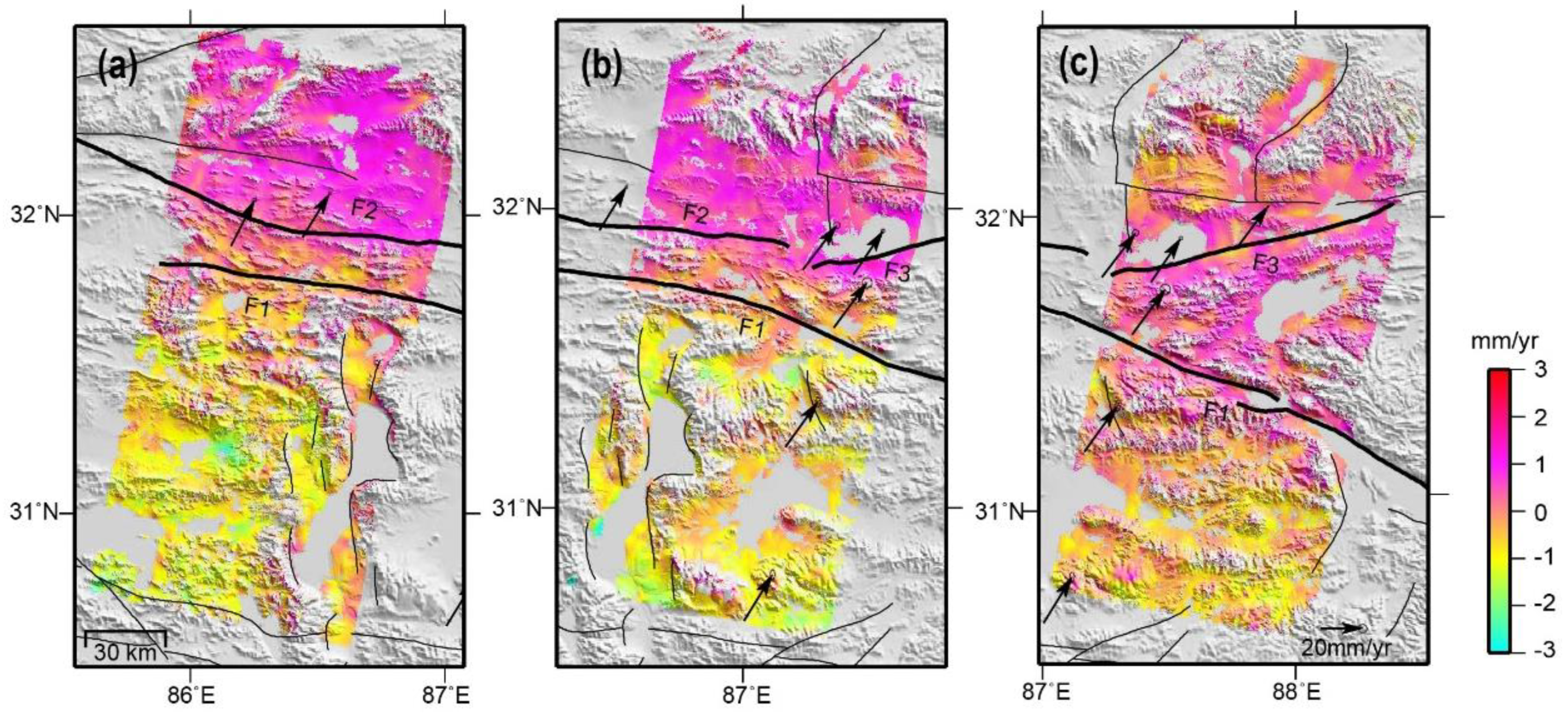
2.2. InSAR Velocity Field
2.3. Accuracy Assessment of InSAR Velocity Field
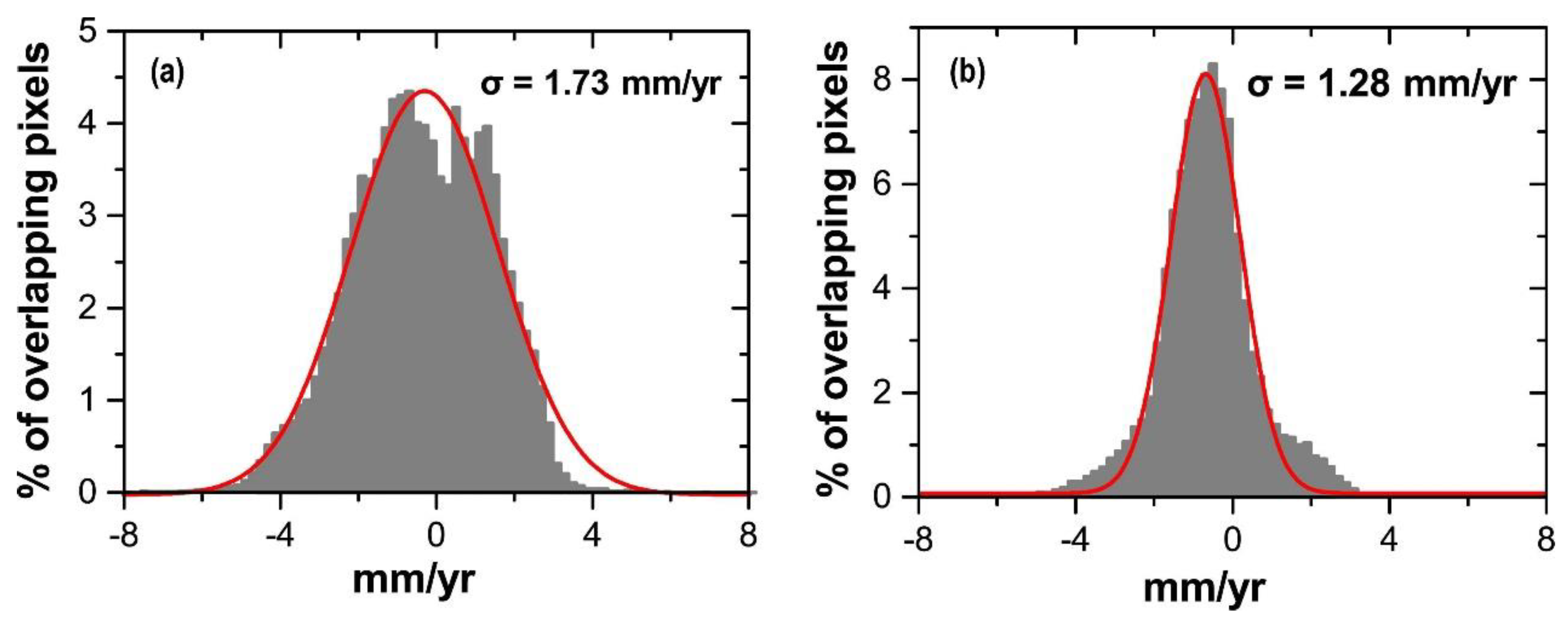
2.3.1. Accuracy Assessment of Overlapping Areas of Adjacent Orbits
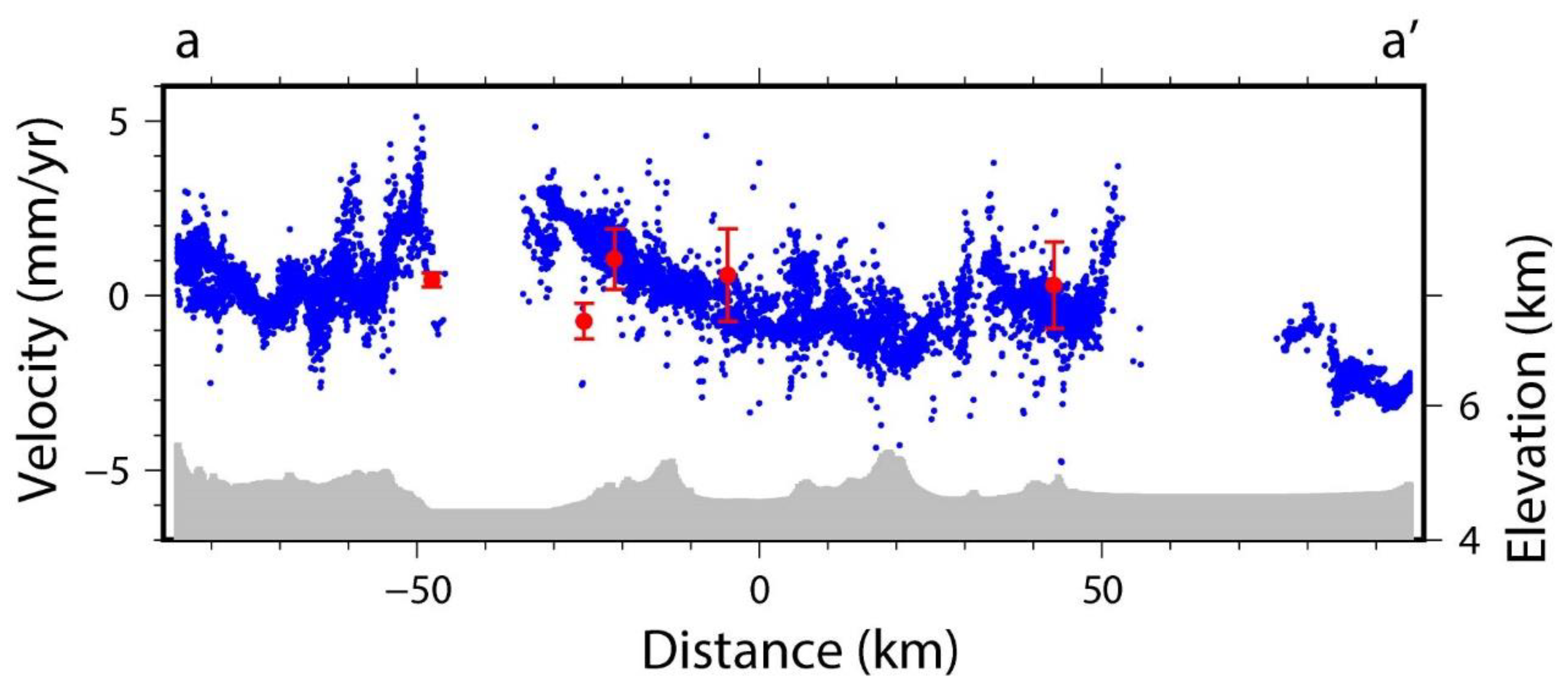
2.3.2. Comparisons between InSAR and Global Position System (GPS) Results
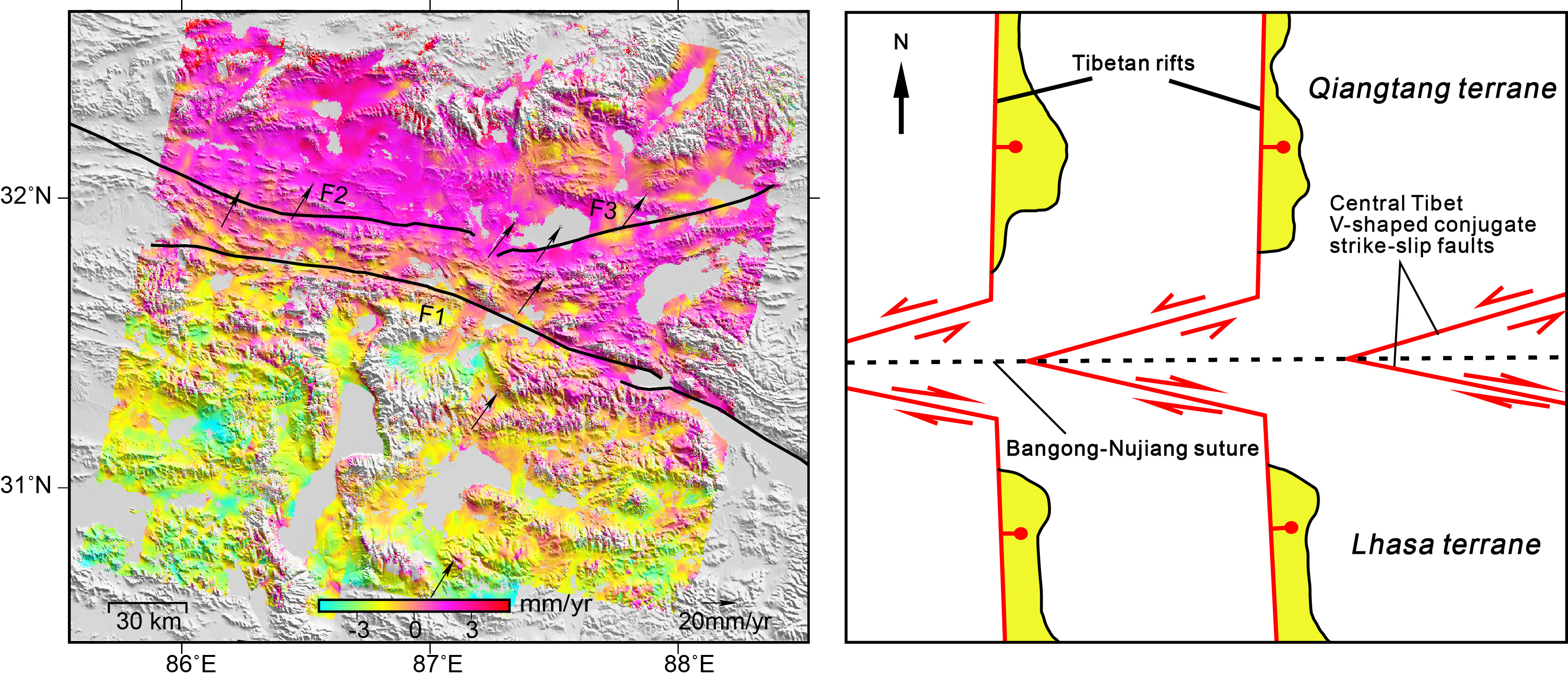
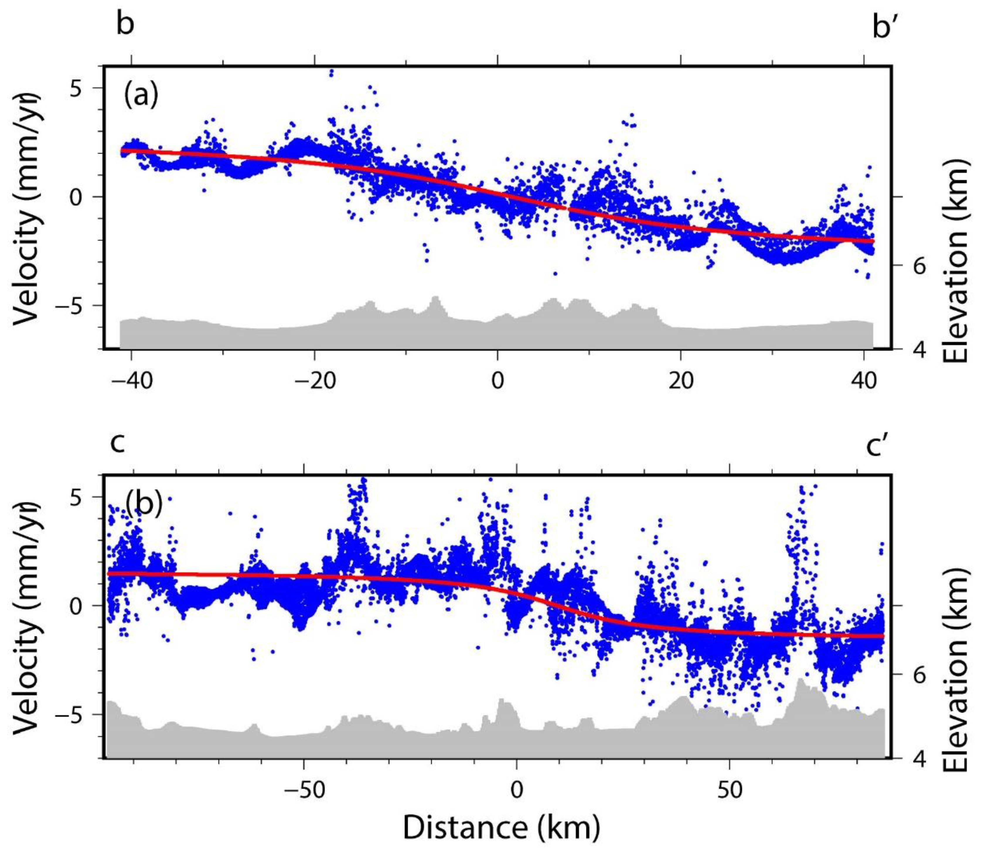
3. Inter-Seismic Slip Rates and Locking Depth of the Gyaring Co Fault Zone
4. Discussion
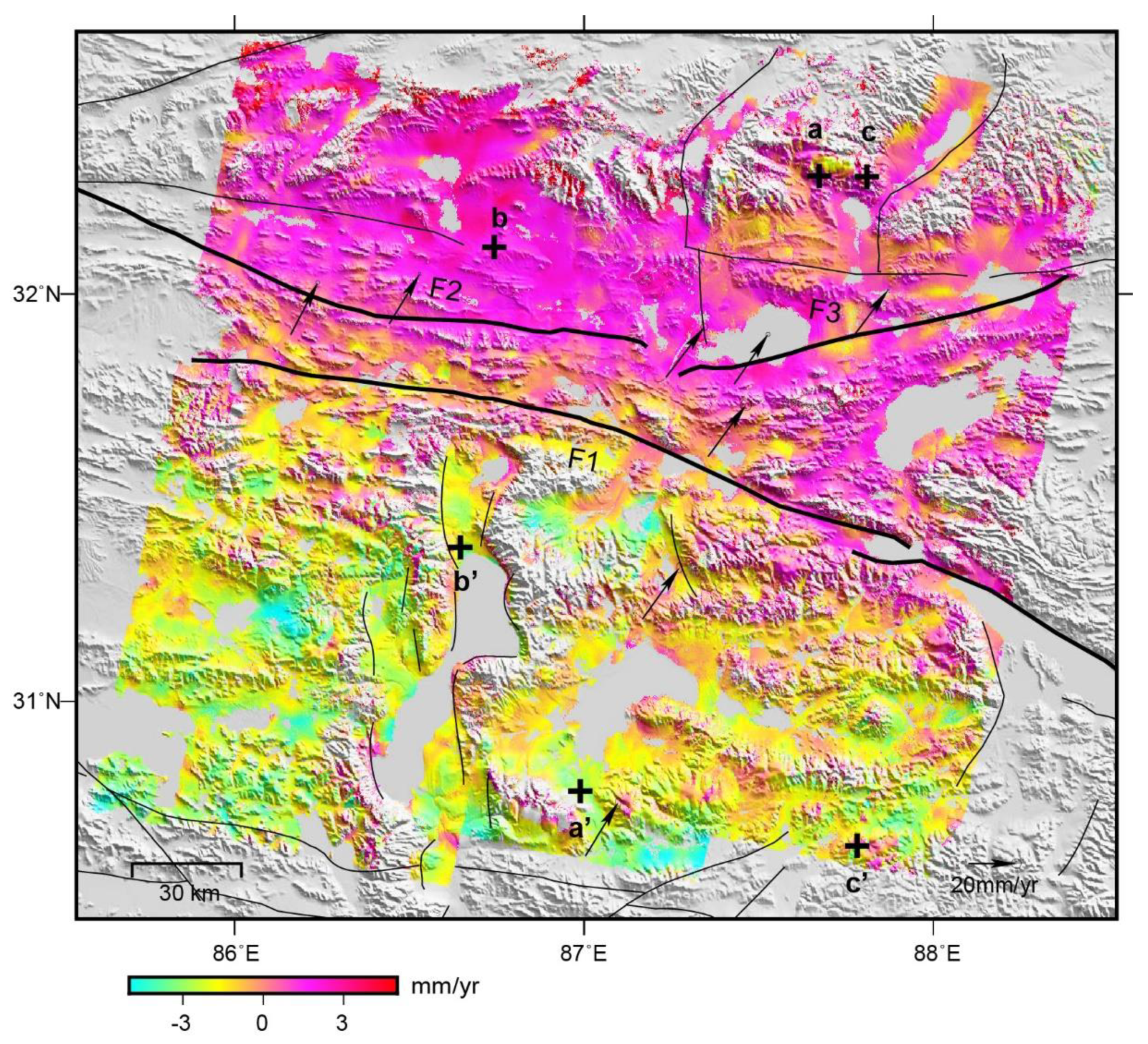
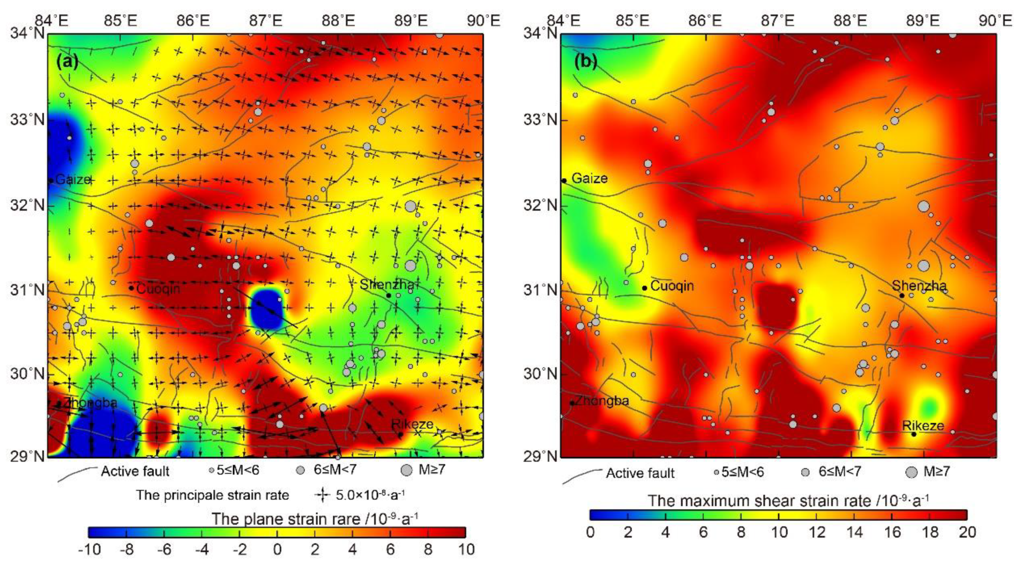
4.1. Analysis of the Current Crustal Strain State of the Gyaring Co Fault and Nearby Areas
4.2. Regional Fault Movement Indicated by the InSAR Deformation Field
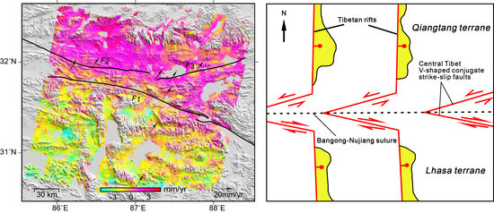
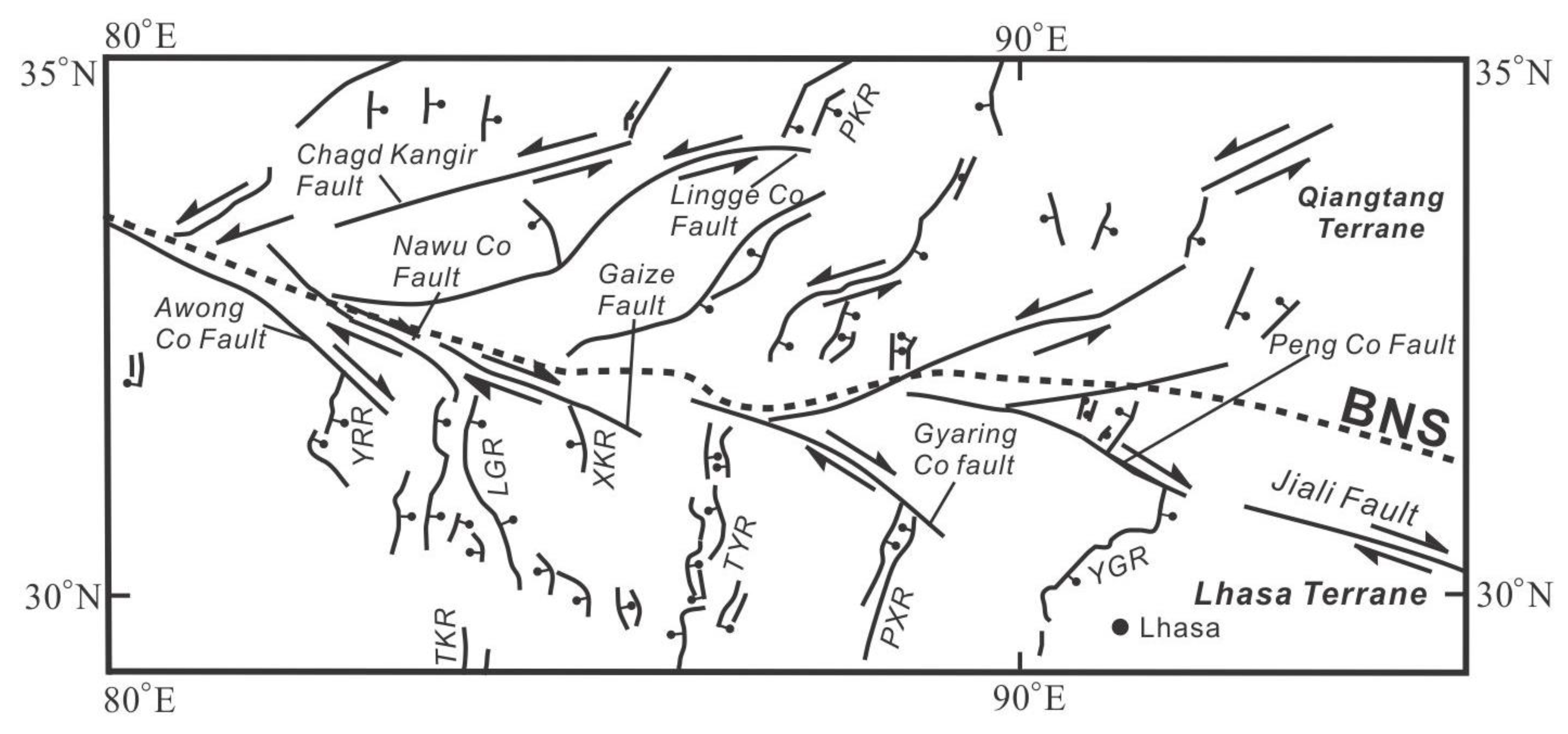
4.3. Analysis of the Kinematic Characteristics of Regional Tectonics
4.4. Tectonic Style of the Bangong–Nujiang Suture
5. Conclusions
Author Contributions
Funding
Acknowledgments
Conflicts of Interest
References
- Armijo, R.; Tapponnier, P.; Mercier, J.L. Quaternary extension in southern Tibet: Field observations and tectonic implications. J. Geophys. Res. Solid Earth 1986, 91, 13803–13872. [Google Scholar] [CrossRef]
- Armijo, R.; Tapponnier, P.; Han, T. Late Cenozoic right-lateral strike-slip faulting across southern Tibet. J. Geophys. Res. 1989, 94, 2787–2838. [Google Scholar] [CrossRef]
- Molnar, P. The geologic evolution of the Tibet plateau. Am. Sci. 1589, 77, 350–360. [Google Scholar]
- Wu, Z.; Cao, Z.; Shen, B.; Deng, Q. Seismogenic tectonics in the central Tibet. earthquake research in china. Chin. J. Geophys. 1994, 10, 19–27. [Google Scholar]
- Yang, P.; Chen, Z.; Zhang, J.; Ren, J. The tension-shear of Gyaring Co Fault and the implication for dynamic model in South-central Tibet. Chin. J. Geophys. 2012, 55, 3285–3295. [Google Scholar]
- Shen, J.; Wang, Y.; Ren, J. Quaternary dextral shearing and crustal movement in southeast Tibetan Plateau. Xinjiang Geol. 2003, 21, 120–125. [Google Scholar]
- Zhong, D.L.; Ding, L. Research on the uplift process and mechanism of the Tibetan plateau. Sci. China (Ser. D) 1996, 26, 289–295. [Google Scholar]
- Wang, Q.; Zhang, P.Z.; Freymueller, J.T. Present-Day crustal deformation in China constrained by global positioning system measurements. Science 2001, 294, 574–577. [Google Scholar] [CrossRef]
- He, S.; Ding, L.; Wu, G. Quaternary activity of Ziguicuo Fault in Gayringco area, south Xizang, and its tectonic implications. Chin. J. Geol. 2002, 37, 8–12. [Google Scholar]
- Ren, J.; Shen, J.; Cao, Z.; Wang, Y. Quaternary Faulting of Jiali Fault, southeast Tibetan Plateau. Seismol. Geol. 2000, 22, 344–350. [Google Scholar]
- Massonnet, D.; Rossi, M.; Carmona, C.; Adragna, F.; Peltzer, G.; Feigl, K. The displacement field of the landers earthquake mapped by radar interferometry. Nature 1993, 364, 138–142. [Google Scholar] [CrossRef]
- Ji, L.; Wang, Q.; Xu, J.; Ji, C. The July 11, 1995 Myanmar–China earthquake: A representative event in the bookshelf faulting system of southeastern Asia observed from JERS-1 SAR images. Int. J. Appl. Earth Observ. Geoinf. 2017, 55, 43–51. [Google Scholar] [CrossRef]
- Gonzalez-Ortega, A.; Fialko, Y.; Sandwell, D.; Nava-Pichardo, F.A.; Fletcher, J.; Gonzalez-Garcia, J.; Lipovsky, B.; Floyd, M.; Funning, G. Elmayor-Cucapah (Mw 7.2) earthquake: Early near-field postseismicdeformation from InSAR and GPS observations. J. Geophys. Res. 2014, 119, 1482–1497. [Google Scholar] [CrossRef]
- Liu, C.J.; Ji, L.Y.; Zhu, L.Y.; Zhao, C.Y. InSAR-Constrained Interseismic Deformation and Potential Seismogenic Asperities on the Altyn Tagh Fault at 91.5–95°E, Northern Tibetan Plateau. Remote Sens. 2018, 10, 943. [Google Scholar] [CrossRef]
- Tong, X.; Sandwell, D.T.; Smith-Konter, B. High-resolution interseismic velocity data along the San Andreas fault from GPS and InSAR. J. Geophys. Res. 2013, 118, 369–389. [Google Scholar] [CrossRef]
- Hussain, E.; Wright, T.; Walters, R.; Bekaert, D.; Lloyd, R.; Hooper, A. Constant strain accumulation rate between major earthquakes on the north anatolian fault. Nat. Commun. 2018, 9, 1392. [Google Scholar] [CrossRef]
- Jolivet, R.; Lasserre, C.; Doin, M.-P.; Guillaso, S.; Peltzer, G.; Dailu, R.; Sun, J.; Shen, Z.-K.; Xu, X. Shallow creep on the Haiyuan Fault (Gansu, China) revealed by SAR Interferometry. J. Geophys. Res. 2012, 117, 06401. [Google Scholar] [CrossRef]
- Tong, X.; Sandwell, D.T.; Schmidt, D.A. Surface creep rate and moment accumulation rate along the Aceh segment of the Sumatran fault from L-band ALOS-1/PALSAR-1 observations. Geophys. Res. Lett. 2018, 45, 3404–3412. [Google Scholar] [CrossRef]
- Wang, H.; Wright, T.J.; Biggs, J. Interseismic slip rate of the northwestern Xianshuihe fault from InSAR data. Geophys. Res. Lett. 2009, 36, 139–145. [Google Scholar] [CrossRef]
- Zhang, P.Z.; Deng, Q.D.; Zhang, G.M.; Ma, J.; Gan, W.; Min, W.; Mao, F.; Wang, Q. Active tectonic blocks and strong earthquakes in the continent of China. Sci. China (Ser. D) 2003, 46, 13–24. [Google Scholar]
- Xu, X.W.; Han, Z.J.; Yang, X.P. Seismotectonic Map in China and Its Adjacent Regions; Seismological Press: Beijing, China, 2016. [Google Scholar]
- Zheng, G.; Wang, H.; Wright, T.J.; Lou, Y.; Zhang, R.; Zhang, W.; Shi, C.; Huang, J.; Wei, N. Crustal deformation in the India-Eurasia collision zone from 25 years of GPS measurements. J. Geophys. Res. 2017, 122, 9290–9312. [Google Scholar] [CrossRef]
- Werner, C.; Wegmüller, U.; Strozzi, T. GAMMA SAR and interferometric processing software. In Proceedings of the ERS-Envisat Symposium, Gothenburg, Swedish, 16–20 October 2000. [Google Scholar]
- Lu, Z.; Dzurisin, D. Ground surface deformation patterns, magma supply, and magma storage at Okmok volcano, Alaska, from InSAR analysis: 2. Coeruptive deflation, July–August 2008. J. Geophys. Res. Solid Earth 2010, 115, B00B03. [Google Scholar] [CrossRef]
- Jiang, M.; Ding, X.; Hanssen, R.F.; Malhotra, R.; Chang, L. Fast statistically homogeneous pixel selection for covariance matrix estimation for multitemporal insar. IEEE Trans. Geosci. Remote Sens. 2015, 53, 1213–1224. [Google Scholar] [CrossRef]
- Garthwaite, M.C.; Wang, H.; Wright, T.J. Broadscale interseismic deformation and fault slip rates in the central Tibetan Plateau observed using InSAR. J. Geophys. Res. Solid Earth 2013, 118, 5071–5083. [Google Scholar] [CrossRef]
- Biggs, J.; Wright, T.; Lu, Z. Multi-interferogram method for measuring interseismic deformation: Denali Fault, Alaska. Geophys. J. Int. 2007, 170, 1165–1179. [Google Scholar] [CrossRef]
- Elliott, J.R.; Biggs, J.; Parsons, B. InSAR slip rate determination on the Altyn Tagh Fault, northern Tibet, in the presence of topographically correlated atmospheric delays. Geophys. Res. Lett. 2008, 35, 82–90. [Google Scholar] [CrossRef]
- Lyons, S.; Sandwell, D. Fault creep along the southern San Andreas from interferometric synthetic aperture radar, permanent scatterers, and stacking. J. Geophys. Res. 2003, 108, 2047. [Google Scholar] [CrossRef]
- Savage, J.C.; Burford, R.O. Geodetic determination of relative plate motion in central California. J. Geophys. Res. 1973, 78, 832–845. [Google Scholar] [CrossRef]
- Shen, Z.-K.; Wang, M.; Zeng, Y.; Wang, F. Optimal interpolation of spatially discretized geodetic data. Bull. Seismol. Soc. Am. 2015, 105, 2117–2127. [Google Scholar] [CrossRef]
- Ge, W.P.; Molnar, P.; Shen, Z.K.; Li, Q. Present-day crustal thinning in the southern and northern Tibetan plateau showed by GPS measurements. Geophys. Res. Lett. 2015, 42, 5227–5235. [Google Scholar] [CrossRef]
- Wang, D. Tectonic Geomorphology along the Gyaring Co Fault in Central Tibet; Institue of Geology, China Earthquake Administration: Beijing, China, 2018. [Google Scholar]
- Yang, P. Late Quaternary Activity of the Gayring Co Fault and its Implication for Dynamics of the Southern-Central Tibetan Plateau; Institue of Geology, China Earthquake Administration: Beijing, China, 2014. [Google Scholar]
- Yin, A.; Taylor, M.H. Mechanics of v-shaped conjugate strike-slip faults and the corresponding continuum mode of continental deformation. Geol. Soc. Am. Bull. 2011, 123, 1798–1821. [Google Scholar] [CrossRef]


| Orbit Type | Wavelength | Orbit Number | Time Span | Number of Images | Number of Interferograms |
|---|---|---|---|---|---|
| Descending | 5.6 cm | 305 | October 2003–August 2010 | 29 | 73 |
| Descending | 5.6 cm | 33 | March 2003–October 2010 | 32 | 94 |
| Descending | 5.6 cm | 262 | November 2003–July 2010 | 32 | 57 |
© 2019 by the authors. Licensee MDPI, Basel, Switzerland. This article is an open access article distributed under the terms and conditions of the Creative Commons Attribution (CC BY) license (http://creativecommons.org/licenses/by/4.0/).
Share and Cite
Zhang, Y.; Liu, C.; Zhang, W.; Jiang, F. Present-Day Deformation of the Gyaring Co Fault Zone, Central Qinghai–Tibet Plateau, Determined Using Synthetic Aperture Radar Interferometry. Remote Sens. 2019, 11, 1118. https://doi.org/10.3390/rs11091118
Zhang Y, Liu C, Zhang W, Jiang F. Present-Day Deformation of the Gyaring Co Fault Zone, Central Qinghai–Tibet Plateau, Determined Using Synthetic Aperture Radar Interferometry. Remote Sensing. 2019; 11(9):1118. https://doi.org/10.3390/rs11091118
Chicago/Turabian StyleZhang, Yong, Chuanjin Liu, Wenting Zhang, and Fengyun Jiang. 2019. "Present-Day Deformation of the Gyaring Co Fault Zone, Central Qinghai–Tibet Plateau, Determined Using Synthetic Aperture Radar Interferometry" Remote Sensing 11, no. 9: 1118. https://doi.org/10.3390/rs11091118
APA StyleZhang, Y., Liu, C., Zhang, W., & Jiang, F. (2019). Present-Day Deformation of the Gyaring Co Fault Zone, Central Qinghai–Tibet Plateau, Determined Using Synthetic Aperture Radar Interferometry. Remote Sensing, 11(9), 1118. https://doi.org/10.3390/rs11091118