Abstract
Underground coal mining-induced subsidence threatens farmland resources and ecological sustainability in coal–grain overlapping regions with high groundwater tables, making concurrent mining and reclamation a critical management need. Previous studies have not systematically compared the integrated effects of mining sequence, extraction method, and panel optimization on subsidence control and reclamation efficiency in such regions. This study designed six mining schemes, integrating these three technical factors to investigate spatiotemporal subsidence evolution and the performance of deep digging–shallow filling reclamation. Findings reveal that mining design synergistically regulates short-to-mid-term subsidence: deep–thin seam-first skip mining eliminates initial severe subsidence damage, while shallow-thick seam-first sequential mining induces the most severe early-stage ecological disturbance. After a full extraction of both coal seams, long-term surface damage converges to 2374 ha (1509 ha severe damage), dictated by total extracted coal volume and inherent geological conditions. Reclamation efficiency depended on earthwork availability and terrain adaptability, with the optimal scheme achieving a reclamation rate of 65.00%. The findings identify mining strategies that balance subsidence mitigation and farmland restoration, providing actionable insights for sustainable mining in high-groundwater coal–grain overlapping regions.
1. Introduction
China’s energy structure, characterized by abundant coal, limited oil, and scarce natural gas, along with growing societal energy demands, has established the country as a major producer and consumer of coal [1]. Over 92% of domestic coal output is extracted via underground mining. The widely employed longwall mining method [2,3] with caving roof management often leads to overburden failure and significant land subsidence [4,5]. While coal resources provide a solid foundation for national economic development, large-scale mining activities have resulted in extensive subsidence areas [6,7]. This issue is particularly prominent in eastern China, where major coal and grain production zones spatially overlap, forming “coal–grain overlapping regions [8,9].” Moreover, the combination of shallow groundwater levels and multiple mineable coal seams [10] in these areas causes widespread degradation of high-quality farmland [11,12] due to waterlogging and subsidence, severely constraining the sustainable development of both energy and food security [13,14,15].
Subsidence-induced farmland damage stems fundamentally from overburden failure and surface deformation caused by mining [16,17]. The most direct and effective strategy is source control to prevent subsidence and protect farmland—shifting from passive remediation to active prevention [18,19]. Through long-term research and engineering practice, China has developed a comprehensive theoretical and technical framework for controlling mining-induced subsidence under sensitive surface conditions, primarily including strip mining [20,21], backfill mining [22,23], and coordinated mining [24]. Among these, strip mining reduces surface deformation by limiting extraction panels, achieving a subsidence factor of 0.05–0.25. However, its coal recovery rate is only 40–50%, resulting in substantial resource waste and conflicting with the dual goals of coal production and farmland preservation in composite regions. Backfill mining [25], which replaces extracted coal with filling materials, can reduce the subsidence factor to 0.06–0.40. It offers advantages, such as high resource recovery, effective subsidence control, and the utilization of solid waste [26]. Yet, its application in eastern multi-seam mining areas is limited by the scarcity of filling materials, the need for specialized equipment, and the higher cost per ton of coal, especially given the large scale and intensity of subsidence in these regions. Therefore, there is an urgent need to develop innovative mining and reclamation technologies that reconcile underground coal extraction with surface farmland protection in coal–grain overlapping regions [27]. In addition, the traditional “end-of-pipe governance” reclamation model for coal mining subsidence land has drawbacks, such as the long-term abandonment of damaged land, a low farmland reclamation rate, and poor quality of reclaimed farmland. It cannot effectively address the vicious accumulation of dynamic mining-induced subsidence land in operating coal mines, nor can it meet the dual demand for the coordinated development of coal mining and farmland protection.
Underground coal mining will inevitably cause ecological impacts [28,29,30]. In high-groundwater-level composite regions, the realistic approach is not to pursue “zero damage” to farmland [31], but to regionally and phase-wise control the extent and spatiotemporal evolution of surface subsidence [32,33] based on mining conditions and surface protection needs [34]. This should be achieved while maintaining mine production continuity and capacity, thereby creating favorable conditions for efficient and timely surface reclamation. This strategy represents a practical and effective technical pathway to address the current challenges.
To tackle the issues of large-scale farmland subsidence and severe ground deformation, this study proposes an integrated underground-surface coordination method tailored to farmland protection. The approach adopts a unified design that couples mining sequence, panel layout, and reclamation scheme. Leveraging the relatively high tolerance of farmland to subsidence deformation, the approach uses deformation thresholds as constraints. A prediction model based on the probability integral method was established to simulate surface movement under various mining scenarios, enabling the optimization of panel layout parameters. By combining underground subsidence control techniques with surface restoration measures, the method synergistically enhances farmland protection. The results enrich the technical framework for subsidence mitigation and farmland rehabilitation, providing valuable insights for the coordinated development of high-level coal mining and high-quality farmland conservation in coal–grain overlapping areas.
The objectives of this study are threefold: to propose and validate an integrated underground-surface coordination method applicable to mining areas with high groundwater tables; to quantitatively evaluate the dynamic surface deformation and reclamation potential under different mining-reclamation scenarios; and to identify optimal strategy combinations that balance mining efficiency, subsidence control, and farmland restoration, thereby providing a technical foundation for sustainable agro-ecological development in mining regions.
2. Materials and Methods
2.1. Overview of the Study Area
The Guqiao coal mine is situated in Fengtai County, Huainan City, Anhui Province, covering a total area of 91.9 km2 (Figure 1). Commissioned in 2007, the mine has an approved annual production capacity of 9.0 million tonnes. It primarily extracts coal seam 13-1, with an average thickness of 4 m, and coal seam 11-2, averaging 3 m in thickness. The working faces for these two seams are largely overlapping, with an interburden of approximately 70 m, and are mined at an average depth of −570 m. The fully mechanized top-coal caving mining method is employed, with the roof managed using the caving method.
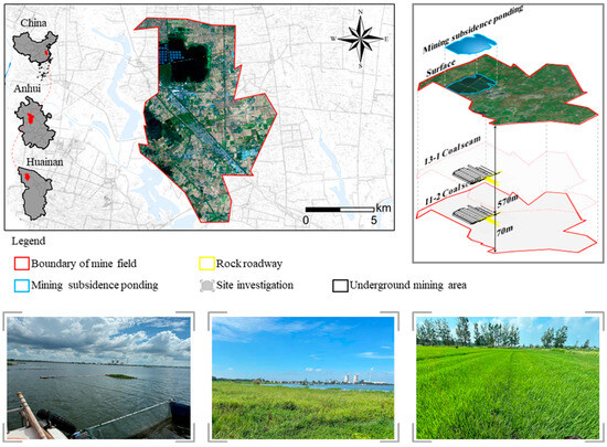
Figure 1.
Location of the Guqiao coal mine.
The mining area features flat terrain, with an average surface elevation of +23.6 m and a shallow groundwater table at about 1.5 m below ground level. The predominant land use is farmland. Site investigations indicate that underground coal mining has induced significant surface subsidence. When the subsidence depth exceeds 1.5 m, perennial waterlogging occurs, resulting in severely damaged areas. Subsidence basins with depths between 1 m and 1.5 m experience seasonal waterlogging during rainy periods and are classified as moderately damaged. Areas with subsidence less than 1 m are considered lightly damaged.
2.2. Technical Approach to Concurrent Mining and Reclamation
Surface movement and deformation induced by different underground mining schemes directly influence the planning of dynamic land reclamation and affect reclamation efficiency. In coal–grain overlapping areas with high groundwater tables, there is a critical need to optimize coal seam layouts to regulate the magnitude and spatiotemporal evolution of surface subsidence, thereby creating favorable conditions for implementing dynamic reclamation. The core logic of concurrent mining and reclamation lies in fully considering the coupling effect between underground mining activities and surface reclamation measures. By implementing zoned and phased control over surface deformation in subsidence areas, it achieves the coordinated advancement of high-efficiency coal extraction and high-standard farmland protection, ultimately realizing the sustainable development of mining areas. This technology aims to prolong the service life of farmland in mining subsidence areas, shorten the reclamation cycle, and improve reclamation efficiency so as to realize the coordinated and sustainable development of high-quality exploitation of underground coal resources and high-standard protection of surface farmland and ecological environment.
Unlike conventional mining layouts that employ descending extraction in the same panel or sequential mining in the same seam, as well as the traditional end treatment approach for subsidence farmland protection, the technique adopts an integrated design strategy. It holistically considers surface protection needs, reclamation requirements, and geological conditions to adjust the underground mining sequence and panel layout scientifically. This creates suitable technical conditions for dynamic reclamation and forms a concurrent mining and reclamation system.
Specifically, on the one hand, in the same mining area, the large depth-thickness coal seam is preferred as the first coal seam to reduce the surface subsidence degree of the first coal seam mining; on the other hand, in the first coal seam working face, the phased skip mining–full-mining process is used to stage and regionally control the surface subsidence degree of the coal mining subsidence area, and adjust the law of surface movement and deformation so as to promote the surface in the whole stage or part of the stage to be in the state of insufficient mining, ensure that the maximum surface subsidence does not exceed the critical subsidence value of farmland, and prolong the service life of farmland in mining subsidence area. Then, the surface movement and deformation are rapid throughout the whole mining stage, which creates a technical application environment for the centralized and efficient development of dynamic land reclamation so as to improve the reclamation efficiency and shorten the reclamation duration.
2.3. Regional Surface Subsidence Prediction Method
2.3.1. Mathematical Model of the Depth–Thickness Ratio and Surface Subsidence
In high-water-table mining areas, the extraction of two or multiple coal seams is prevalent, with significant variations in mining depth and thickness among individual seams. When the coal seam group within a mining panel exhibits heterogeneous thickness, four distinct mining sequence combinations exist for two-seam repeated extraction: (a) initial extraction of a thick lower seam followed by upward mining; (b) initial extraction of a thin upper seam followed by downward mining; (c) initial extraction of a thick upper seam followed by downward mining; and (d) initial extraction of a thin lower seam followed by upward mining, as shown in Figure 2.
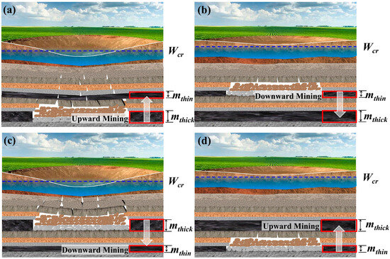
Figure 2.
Characteristics of overburden strata movement and surface deformation due to underground mining with different D/T of the first coal seam. (a) Initial extraction of a thick lower seam followed by upward mining; (b) initial extraction of a thin upper seam followed by downward mining; (c) initial extraction of a thick upper seam followed by downward mining; and (d) initial extraction of a thin lower seam followed by upward mining.
Under consistent mining depth conditions, increased extraction height leads to expansion of the caved zone above the goaf, accompanied by proportional extension of the fractured zone and bending zone, consequently amplifying surface movement and deformation. When maintaining constant mining thickness, the maximum surface subsidence demonstrates a positive correlation with extraction height. Hence, the extraction sequencing of coal seams with varying depth–thickness ratios (D/T) fundamentally determines the spatiotemporal evolution patterns of surface subsidence.
The probability integral method (PIM) is a subsidence prediction approach derived from the theory of stochastic media. Under this theory, the subsidence basin induced by an elemental mining unit is assumed to follow a normal distribution, consistent with the corresponding probability density function. Accordingly, mining-induced surface subsidence can be expressed as an integral formulation of the probability density function. Owing to its clear parameterization, ease of calibration, and strong engineering practicality, PIM has been widely adopted for coal mining subsidence prediction across mining regions in China.
According to the probability integral method [35] for predicting mining-induced subsidence, when the underground coal seam is extracted over a strike extent D3 and a dip extent D1, the subsidence at an arbitrary surface point (x, y) caused by the full extraction of the panel (mined-out space) is given by
In the equation, W0 represents the maximum subsidence value throughout the entire mining process, and the parameter r represents the radius of the major influence zone. Moreover, l and L represent the calculated strike and dip lengths, respectively, while s and t are the transverse and longitudinal coordinates of the mining element. The units and physical meanings of the parameters are summarized in Table 1.

Table 1.
Summary of key parameters used in Equation (1).
The subsidence value W(x, y) at any surface point (x, y) can be calculated using the double integral given in Equation (1). The solution of this integral proceeds in two steps: first, the inner integration is performed with respect to the variable t over the interval [0, L], yielding the function F(s) of the outer integration variable s; subsequently, the outer integration of F(s) is carried out with respect to s over the interval [0, 1]. Furthermore, based on the parameter definitions provided in Table 1, the expressions for W0 and r are substituted into Equation (1), allowing it to be explicitly expressed as a function of the depth-to-thickness ratio H/m. The final form is presented in Equation (2) (the detailed derivation is provided in Equation (A1) in Appendix A).
It is evident that a larger depth-to-thickness ratio (H/m) results in smaller and more gradual surface movement and deformation, whereas a smaller ratio leads to more intense and abrupt displacement and distortion.
From the perspective of cultivated land protection in coal–grain overlapping areas with high groundwater levels, it is essential to ensure that surface subsidence remains within the critical tolerable subsidence value Wcr for farmland to maintain normal agricultural use of the surface land in mining-induced subsidence areas.
In this study, Wcr denotes the critical allowable subsidence value for farmland, defined as the maximum subsidence threshold that does not induce waterlogging or significant degradation of agricultural functions under high-groundwater-table conditions. Mechanistically, Wcr is governed by multiple factors, including groundwater depth, soil texture, drainage capacity, and the required thickness of the unsaturated zone for crop root development. This parameter was determined by integrating several lines of evidence: seasonal groundwater level observations in the study area, agronomic and drainage requirements for minimum unsaturated zone depth, and empirical thresholds for waterlogging-induced land degradation derived from field surveys and historical restoration experience. Based on this, Wcr was incorporated as a “deformation threshold constraint” into the integrated mining-reclamation design. Specifically, during the panel-skipping stage, the maximum subsidence (Wskip-max) was controlled to satisfy Wskip-max ≤ Wcr, thereby preserving farmland usability and creating favorable conditions for subsequent dynamic reclamation.
Mining a coal seam with a high depth-to-thickness ratio (H/m) in the initial extraction phase can significantly reduce the extent of surface movement and deformation during early mining stages. If the maximum surface subsidence remains within the critical tolerable subsidence value Wcr for farmland, the early-stage surface subsidence can be mitigated to some extent. This approach not only prolongs the service life of cultivated land but also shortens the surface reclamation cycle.
2.3.2. Mathematical Model for Surface Superimposed Subsidence
Research on the relationship between panel extraction degree and surface deformation reveals that conventional continuous mining sequences induce intensive surface movement, leading to rapid attainment of critical subsidence. In high-water-table mining regions, this results in prompt waterlogging following extraction, necessitating early reclamation intervention and consequently extending the concurrent mining–reclamation cycle.
Surface subsidence increases gradually with panel extraction area during initial mining stages; however, once extraction exceeds a critical threshold, deformation intensifies abruptly. Effective subsidence control can be achieved by constraining the extraction scope within this critical limit.
Given the shallow groundwater level (approximately 1.5 m below the surface) and typical mining heights of 3–5 m in coal–grain overlapping areas with a high water table, the design of the first-mined seam is crucial for surface subsidence management.
Leveraging the characteristics of subcritical mining deformation and considering the vast farmland area with variable deformation tolerance, a two-phase extraction strategy for a single seam is proposed. Initially, skip mining is implemented to reduce surface movement and prolong farmland functionality. Subsequently, total extraction of remaining panels accelerates surface deformation, enabling concentrated and efficient dynamic reclamation. This approach achieves regional and phased control over subsidence magnitude and spatiotemporal evolution, forming an integrated underground coordination method for simultaneous mining and reclamation in high-groundwater-table farmland subsidence areas.
The key to successful regional and staged subsidence control via skip mining lies in optimizing the layout parameters of skip-mining panels and accurately predicting phase-specific surface deformation.
Focusing on the width of skip-mining panels, the degree of subsidence control can be categorized into two types: full-period and full-area control and staged and zonal control, both serving the implementation of subsequent dynamic reclamation.
- (1)
- Full-period and area-wide subsidence control
Taking the mining of a horizontal coal seam as an example (Figure 3), A1, A2, A3, …, and Aᵢ represent the skip-mining panels. The actual width of a single skip-mining panel is denoted as lskip-act, the calculated mining width as lskip-cal, and the inflection point offsets as S1 and S2, which satisfy the following conditions:
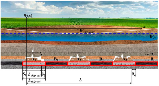
Figure 3.
Characteristics of overburden strata movement and surface deformation due to working face mining in the skip-mining stage.
B1, B2, B3, …, and Bᵢ represent the full-extraction panels. The actual width of a single full-extraction panel is denoted as lfull-act, and the calculated total length of the cumulative mining area is L.
A coordinate system is established with the left boundary of the calculated length of the first skip-mining panel A1 as the origin. The surface subsidence in the x-direction during skip-mining results from the combined influence of panels A1, A2, A3, …, Aᵢ and can be calculated through superposition. According to the probability integral method, the subsidence at any point in the x-direction under finite mining conditions is given by
In the equation, W(x) denotes the subsidence under semi-infinite mining conditions with the left boundary of the mining area as the calculation origin; W(x−l) represents the subsidence under semi-infinite mining conditions with the right boundary as the calculation origin; the value of A can be determined by referring to the probability integral table, where l is the calculated panel width and r is the major influence radius.
Thus, the subsidence value at any surface point induced by mining panel Ai can be expressed as
In the equation, W0 represents the maximum surface subsidence under full-seam caving mining conditions in this region, where W0 = mqcosα. Here, m denotes the mining height of the coal seam, q is the subsidence factor, and α indicates the dip angle of the coal seam.
The cumulative surface subsidence at any arbitrary point induced by the extraction of skip-mining panels 1 to i in the mining area can be ultimately expressed as
For instance, when i = 3, the x-coordinate of the maximum subsidence point located in the central region of the skip-mining area is denoted as x = lskip-act + lfull-act + 0.5lskip-cal. The maximum subsidence value induced by skip-mining area A can then be expressed as
By optimizing the width of skip-mining panels (lskip-act), the maximum surface subsidence after the complete extraction of all skip-mining panels in the mining area can be controlled to remain within the critical tolerable subsidence value for farmland, Wskip-max ≤ Wcr. This ensures that cultivated land within the subsidence basin remains viable for normal agricultural activities throughout the entire skip-mining process.
- (2)
- Comprehensive Subsidence Control Across Temporal and Spatial Domains
Considering that reducing the panel width may lead to lower production capacity during the skip-mining phase, along with increased face relocations and decreased development rate, an alternative approach is proposed: maintaining a constant panel width throughout the skip-mining process. This ensures that during the extraction of the initial series of skip-mining panels (1 to i), the maximum surface subsidence remains below the critical tolerable subsidence value for farmland, i.e., Wskip-max(1∼i) ≤ Wcr. Consequently, this strategy enables partial preservation of cultivated land within the subsidence basin for normal agricultural use in a phased and zonal manner during the early skip-mining stage. Thereby, it supports maintaining production capacity while simultaneously extending the service life of farmland and shortening the reclamation cycle.
With the extraction of full-mining panels B1 and B2 (Figure 4), the x-coordinate of the maximum subsidence point located in the central mining area is denoted as x = lskip-act + lfull-act + 0.5lskip-cal. The maximum surface subsidence value after the complete extraction of panels A1, A2, A3, B1, and B2 can be expressed as
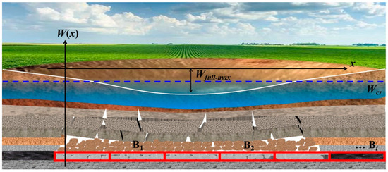
Figure 4.
Characteristics of overburden strata movement and surface deformation due to working face mining in the full-mining stage.
During the full-seam mining phase of the coal seam panel, surface movement and deformation become intense, which facilitates the centralized and efficient implementation of dynamic surface reclamation. This further shortens the overall surface reclamation cycle.
2.4. Technical Framework of Concurrent Mining and Reclamation in Coal Mining Subsidence Area with High Groundwater Tables
According to the implementation timeline, the coordinated simultaneous mining and reclamation technology with underground and surface integration can be divided into three phases (Figure 5):
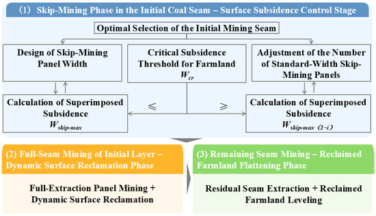
Figure 5.
Design framework of the coordination technology of underground mining and surface reclamation in the coal mining subsidence land with a high groundwater table.
- (1)
- Skip-Mining in the Initial Coal Seam–Surface Subsidence Control Phase
Based on the occurrence conditions of each coal seam within the mining area, the reclamation scope is determined through a decision-making process under repeated multi-seam mining conditions, following the principle of “mining-induced subsidence prediction → reclamation planning based on subsidence → mining design adapted to reclamation requirements”. The initial mining seam is optimally selected using the high depth-to-thickness ratio principle to minimize surface subsidence during the extraction of the first coal seam (Figure 6).
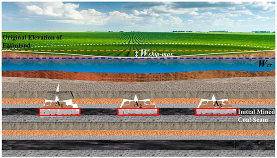
Figure 6.
Early stage of strip mining in the first coal seam–surface subsidence control.
The initial coal seam working face adopts a skip-mining followed by a full-mining sequence, with skip mining conducted first. Based on the principle of farmland protection during the skip-mining phase, the maximum surface subsidence value, Wskip-max, must not exceed the critical subsidence threshold for farmland, Wcr. By calculating the superimposed maximum surface subsidence Wskip-max induced by the skip-mining working face and comparing it with the critical subsidence threshold Wcr, the width of the skip-mining working face is determined under a full-time, full-area subsidence control mode to satisfy Wskip-max ≤ Wcr. Alternatively, under a phased and zoned subsidence control mode, the number of skip-mining working faces with predetermined dimensions is established to ensure Wskip-max(1∼i) ≤ Wcr. By reducing deformation during the surface movement process, the maximum surface subsidence during this period is controlled within the critical subsidence threshold for farmland, thereby preserving the cultivation capacity of the farmland in the coal mining subsidence area.
- (2)
- Full-Seam Mining of the Initial Layer–Dynamic Surface Reclamation Phase
During the full-seam mining of the remaining panels in the initial coal layer, the surface reaches a state of supercritical extraction. Building upon the subsidence effects from the prior skip-mining phase, both the rate and magnitude of surface movement and deformation intensify. Concurrently, dynamic reclamation operations, either with or without backfilling, are carried out on the surface, taking into account the cumulative subsidence expected from the entire planned mining area (Figure 7). As the full-seam panels conclude extraction, the dynamic surface reclamation is simultaneously completed.
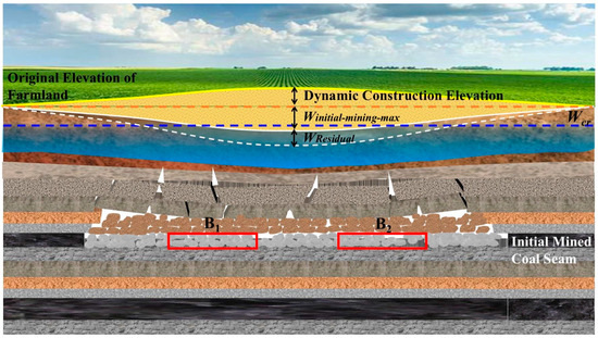
Figure 7.
Mid-stage of full mining in the first coal seam–dynamic reclamation of the surface.
- (3)
- Remaining Coal Seam Mining–Farmland Surface Restoration Phase
Upon completion of the initial mining panel extraction, normal mining of the remaining coal seams can proceed. Under the subsequent influence of mining-induced subsidence from the remaining seams, the reclaimed farmland gradually regains its surface flatness. Following the conclusion of mining activities and subsequent stabilization of surface subsidence, the reclaimed farmland is restored to its designed elevation and seamlessly integrated with the surrounding undisturbed cultivated land (Figure 8). This approach achieves multiple objectives, including ensuring coal resource recovery rates, prolonging the functional duration of farmland, shortening reclamation cycles, and improving farmland restoration efficiency.
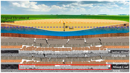
Figure 8.
Late-stage of the remaining coal seams mining–reclaimed farmland recovery flat.
In engineering practice, the mining–reclamation coordination strategy can be further optimized by integrating specific geological and mining conditions, including coal seam depth, mining thickness, and surface farmland protection requirements. For instance, in areas with thicker coal seams, the initial mining layer may adopt techniques such as multi-slice mining to phase-wise reduce the extraction thickness, thereby progressively decreasing the maximum surface subsidence during the initial mining phase. Additionally, the peak surface subsidence in the skip-mining stage can be controlled by adjusting the number and widths of alternately extracted panels between skip-mining and full-mining operations.
3. Results
3.1. Scenario Simulation of Concurrent Mining and Reclamation
The probability integral method, as the most widely used subsidence prediction approach for underground coal mining in various mining areas across China, offers advantages such as easily determinable parameters, reliable computational results, and strong practicality [36]. This subsidence prediction software, based on the probability integral method, was employed to quantitatively analyze and predict surface movement and deformation induced by the extraction of the 13-1 and 11-2 coal seams with a spatial resolution of 30 × 30 m. Based on the actual subsidence monitoring data from other working faces in the Guqiao coal mine, calibration and verification of the prediction parameters for the probability integral method were conducted, leading to the comprehensive selection of all relevant parameters, as detailed in Table 2.
Table 2.
Prediction parameters of the probability integral method in Guqiao coal mine.
Considering both the spatial extent of the subsidence area and the feasibility of planning implementation, this study established the prediction framework based on the current surface water accumulation due to subsidence in the No. 1 north mining area and its future extraction sequencing plan. Spatially, the overlapping extraction panels of the upper (coal seam 13-1) and lower (coal seam 11-2) seams within the No. 1 north mining area were designated as the prediction zone for surface deformation. Temporally, the period from the initiation of mining until the complete extraction of both seams (2023–2035) was defined as the prediction period. A progressive annual analysis of surface subsidence and prediction of zones with varying damage degrees was conducted. According to the regulations of buildings, water, railways, and the main well lane leaving coal pillars and press coal mining, the curve with a surface subsidence of 10 mm is generally defined as the boundary of the subsidence basin.
Integrating the mining sequence, coal seam thickness, and panel dimensions, six distinct mining scenarios were designed as follows:
Mining Scheme I. Sequential-mining initiation with the seam of a small mining depth-to-thickness ratio: first extracting the upper, thicker coal seam 13-1 (4 m), followed by the lower, thinner coal seam 11-2 (3 m).
Mining Scheme II. Sequential-mining initiation with the seam of a large mining depth-to-thickness ratio: first extracting the lower, thinner coal seam 11-2, followed by the upper, thicker coal seam 13-1.
Mining Scheme III. Skip-mining initiation with the seam of a small mining depth-to-thickness ratio: first extracting the upper, thicker coal seam 13-1 using the skip-mining method, followed by the lower, thinner coal seam 11-2.
Mining Scheme IV. Skip-mining initiation with the seam of a large mining depth-to-thickness ratio: first extracting the lower, thinner coal seam 11-2 using the skip-mining method, followed by the upper, thicker coal seam 13-1.
Mining Scheme V. Optimized-skip-mining initiation with the seam of a small mining depth-to-thickness ratio: first extracting the upper, thicker coal seam 13-1 using skip mining with optimized panel dimensions, followed by full extraction of the lower, thinner coal seam 11-2.
Mining Scheme VI. Optimized-skip-mining initiation with the seam of a large mining depth-to-thickness ratio: first extracting the lower, thinner coal seam 11-2 using skip mining with optimized panel dimensions, followed by the upper, thicker coal seam 13-1.
3.2. Land Use Changes Under Different Mining Schemes
The spatiotemporal evolution characteristics of surface subsidence and zones with varying degrees of damage induced by the extraction of upper and lower coal seams under six mining scenarios are illustrated in Figure 9. Specifically, Stage (1) represents the surface subsidence features following the initial mining phase of the first-mined coal seam; Stage (2) corresponds to the surface subsidence characteristics after the subsequent mining phase of the first-mined coal seam; and Stage (3) depicts the surface subsidence profile after the complete extraction of the succeeding coal seam. Each of the upper and lower coal seams has a mining cycle of 5 years. Specifically, both Stage (1) and Stage (2) of the first-mined coal seam have a 2.5-year mining cycle, while Stage (3) of the re-mined coal seam has a 5-year mining cycle.
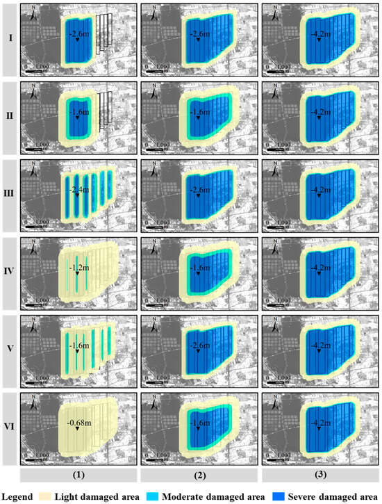
Figure 9.
Spatiotemporal evolution of mining subsidence under different mining schemes.
This section presents the surface damage area distribution of six mining schemes across three stages (Table 3):
Table 3.
Changes in the zoning area of land damage degree under different mining schemes.
Stage (1). The severe damage area varied drastically among schemes: Scheme I had the largest severe damage area (820 ha), while Schemes IV and VI showed no severe damage (0 ha), and Scheme V only had a minimal severe damage area (16 ha). For moderate damage, Scheme III recorded the highest value (226 ha), whereas Schemes IV (44 ha) and VI (0 ha) had relatively low moderate damage. The mild damage area was dominated by Schemes IV (1129 ha) and VI (1128 ha), which were significantly higher than other schemes. The total damage area in Stage (1) ranged from 830 ha (Scheme II) to 1402 ha (Scheme I). The maximum surface subsidence depth of Scheme I reached a maximum of 2.6 m, while that of Scheme VI was the smallest, at 0.68 m.
Stage (2). The severe damage area clustered into two groups: Schemes I, III, and V shared an identical severe damage area (1352 ha), while Schemes II, IV, and VI had a consistent severe damage area of 465 ha. Correspondingly, the moderate damage area was 131 ha (for the first group) and 184 ha (for the second group), and the mild damage area was 586 ha and 539 ha for the two groups, respectively. The total damage area in this stage was 2069 ha (first group) and 1188 ha (second group). The maximum surface subsidence depth of Schemes I, III, and V all reached a maximum of 2.6 m, while that of the remaining schemes was 1.6 m.
Stage (3). Notably, all six schemes exhibited identical damage area distributions in Stage (3): 1509 ha (severe), 101 ha (moderate), and 764 ha (mild), with a total of 2374 ha. This consistency indicates that long-term subsidence damage tends to converge regardless of the initial control schemes. Notably, the maximum surface subsidence depth of all mining schemes reached 4.2 m.
3.3. Reclamation Effect of Subsidence Area Under Different Mining Schemes
Reclamation construction of coal mining subsidence areas is implemented via the engineering measure of deep-digging and shallow-filling. Specifically, in the absence of external filling materials, non-submerged areas within coal mining subsidence areas are excavated to form water storage regions, which are endowed with flood storage and irrigation functions. Subsequently, based on the principle of earthwork balance between digging and filling, the excavated soil is backfilled into the shallow areas of the subsidence zones, restoring the undulating shallow plots of the subsidence area to farmland.
During the construction of deep-digging and shallow-filling reclamation for land reclamation in subsidence areas, the soil excavation depth is determined as 1.5 m based on the depth of the groundwater table. Thereby, the available earthwork volume in the deep-excavation zones and the required earthwork volume for the backfilling zones are initially obtained. Under the constraint of earthwork balance, the boundaries of the deep-excavation and backfilling zones are further defined, and the area of reclaimed farmland is ultimately determined. Under the constraint of earthwork balance, the reclamation rate is defined as the ratio of restored farmland area to the total area damaged by coal mining-induced subsidence.
The spatiotemporal evolution characteristics of the degree and scope of coal mining subsidence vary under six scenarios (Figure 10), which in turn lead to differences in the available earthwork volume and land reclamation efficiency.
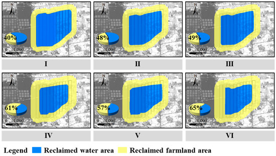
Figure 10.
Spatial distribution of the reclaimed farmland area and reclaimed water area under different scenarios.
Across the six schemes, the available earthwork volume exhibits a distinct upward trend (Table 4), increasing from 3.01 × 10⁶ m3 (Scheme I) to 12.67 × 10⁶ m3 (Scheme VI)—a growth of approximately 321%. Correspondingly, the recoverable cultivated land area increases from 475.27 ha to 772.31 ha, and the reclamation rate rises synchronously, spanning a range from 40.00% (Scheme I, the lowest) to 65.00% (Scheme VI, the highest). This consistent positive correlation initially reflects the dependence of reclamation effectiveness on earthwork supply capacity.
Table 4.
Comparison of reclamation efficiency under different mining schemes.
Notably, Scheme V (available earthwork volume: 8.60 × 10⁶ m3) achieves a lower recoverable cultivated land area (677.26 ha) and reclamation rate (57.00%) than Scheme IV (10.79 × 10⁶ m3 earthwork, 724.79 ha land, 61.00% rate), even though its available earthwork volume is greater than that of Scheme III (5.85 × 10⁶ m3). This finding indicates that available earthwork volume is not the sole determinant of reclamation performance; factors such as the topographic adaptability of subsidence terrain and earthwork utilization efficiency play a pivotal role. In contrast, Scheme IV exhibits high reclamation efficiency relative to its earthwork input, achieving a 61.00% reclamation rate with 10.79 × 10⁶ m3 of earthwork, highlighting its superior parameter matching.
These results underscore significant differences in reclamation potential among the six schemes. Scheme VI outperforms the other schemes in both available earthwork volume and reclamation rate, providing valuable parameter references for large-scale cultivated land reclamation in coal mining subsidence areas. Furthermore, the non-linear correlation between earthwork volume and reclamation rate (evidenced by Scheme V’s underperformance) provides empirical evidence to inform the coordinated optimization of the “earthwork balance–reclamation efficiency” system in subsequent technical adjustments.
4. Discussion
4.1. Mining Scheme Design and Spatiotemporal Subsidence Dynamics
The spatiotemporal divergence (Stages 1–2) and convergence (Stage 3) of surface damage across the six mining schemes reveal the dual role of mining design (sequence, method, and panel optimization) in regulating short-to-mid-term subsidence, while long-term damage is constrained by geological fundamentals.
In Stage (1), Scheme I (sequential mining starting with the shallow, thick 13-1 seam) exhibited the largest severe damage area (820 ha), consistent with prior findings that seams with a small D/T generate greater initial subsidence intensity—shallow, thick seams induce more concentrated overburden deformation. In contrast, Schemes IV and VI (skip mining initiating with the deep, thin 11-2 seam) achieved zero severe damage, as skip mining disperses overburden disturbance, converting potential severe damage into mild, spatially distributed deformation (evidenced by their 1128–1129 ha mild damage) (Figure 11). This demonstrates that combining “deep–thin seam–first sequences” with skip mining is a robust strategy for early-stage ecological risk reduction.
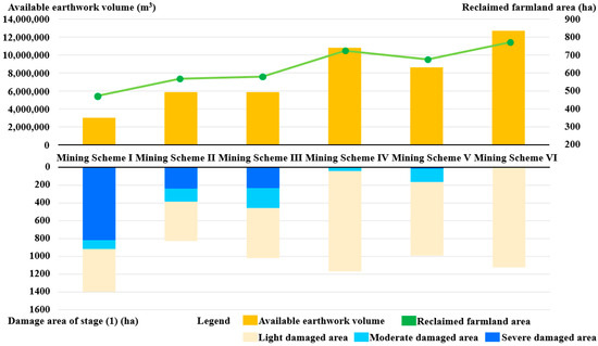
Figure 11.
Comparison of subsidence degree, available earthwork volume, and reclamation area under different mining schemes.
The two-cluster damage pattern in Stage (2) maps directly to mining sequence typology: Schemes I/III/V (starting with small D/T seams) accumulated greater mid-term damage due to cumulative stress from initial thick-seam mining, even with skip methods. Schemes II/IV/VI (starting with large D/T seams) avoided this cumulative effect, as the thin, initial deformation of the deep 11-2 seam was insufficient to trigger extensive overburden failure. This finding extends existing literature by quantifying how mining sequence (not just method) modulates mid-term subsidence accumulation.
Mine extraction in Stage (3) of both seams (total thickness 7 m) drives ultimate overburden collapse, such that mining design only delays geological equilibrium but cannot prevent it, where total extracted coal volume determines long-term surface deformation. Thus, long-term subsidence management should prioritize post-equilibrium adaptive restoration (e.g., stable wetland/farmland configurations) over mining-phase mitigation.
4.2. Comparison of Reclamation Efficiency Based on Earthwork and Terrain Suitability
The positive correlation between earthwork volume (3.01 × 10⁶ to 12.67 × 10⁶ m3) and reclamation rate (40–65%) confirms that deep digging-shallow filling relies on sufficient subsidence-derived earthwork—consistent with circular economy principles for in situ material reuse. However, Scheme V’s underperformance (8.60 × 10⁶ m3 earthwork but 57% reclamation rate, vs. Scheme IV’s 10.79 × 10⁶ m3 and 61%) reveals a critical gap in prior research: earthwork volume alone does not determine reclamation success.
The same skip-mining technology generates completely heterogeneous subsidence terrain due to different panel optimization strategies, which serves as the key driving factor for estimation uncertainty. The optimized skip mining (non-uniform panel extraction) in Scheme V forms irregular and fragmented subsidence terrain, which violates the prerequisite of contiguous and stable subsidence bowls required for deep digging operations, leading to reduced earthwork utilization efficiency. In contrast, skip mining with a non-optimized panel layout in Scheme IV produces uniform shallow subsidence, which aligns with the principle of earthwork balance and ensures reclamation efficiency. This indicates that mining design can significantly alter the corresponding relationship between effective earthwork volume and reclamation performance by regulating terrain morphology, and accurate estimation cannot be achieved solely based on total earthwork volume.
In the future, it is necessary to break through the limitations of traditional linear models and construct a multi-factor coupled estimation framework integrating mining design parameters, subsidence intensity, and terrain morphology evolution so as to effectively reduce uncertainty and maximize reclamation performance.
4.3. Practical Implications for Concurrent Mining and Reclamation
For the coal–grain overlapping areas with high groundwater levels in China, the loss of farmland caused by subsidence water is the core concern:
Early stage risk mitigation: Adopt Scheme VI (skip mining, deep–thin seam first) to eliminate severe initial damage and secure mild deformation.
Reclamation optimization: Prioritize Scheme VI for large-scale farmland restoration (65% reclamation rate) or Scheme IV for cost-efficient earthwork utilization (high efficiency per m3 earthwork).
Long-term management: Standardize Stage 3 reclamation designs (given convergent damage) to reduce planning costs, focusing on farmland–wetland co-configurations to adapt to the 1509 ha severe damage zone.
4.4. Limitations and Future Research
The concurrent mining and reclamation technology for high groundwater table coal mining subsidence areas proposed in this study provides an effective approach to the coordinated development of farmland protection and coal mining in coal–grain overlapping regions yet has some limitations.
First, it focuses on the macro-regulation of the coal seam depth–thickness ratio and coordinated working face mining, lacks targeted schemes for different subsidence zones, and the probability integral method prediction model fails to fully couple key hydrogeological conditions, resulting in insufficient subsidence volume prediction accuracy in complex scenarios. Future research should develop a zoned governance technical system and optimize the model by coupling numerical simulation methods with the probability integral method to improve prediction accuracy.
Second, the proposed framework has not yet been integrated with emerging subsidence-mitigation technologies (e.g., partial backfill mining) and has been validated only through a single case study at the Guqiao coal mine, a representative high-groundwater coal–grain overlapping setting. As a result, the analysis is tailored to this specific geological and hydrogeological context, and its applicability to other coal–grain overlapping regions with different overburden structures, groundwater conditions, and mining scales requires further verification.
Finally, the comprehensive benefits of land reclamation for coal mining subsidence areas in coal–grain overlapping regions are primarily reliant on two key processes: farmland restoration and water area restoration. This study has primarily evaluated reclamation performance based on farmland recovery, focusing on metrics such as the reclamation rate and the feasibility of earthwork operations. A comprehensive sustainability assessment requires a long-term evaluation of environmental impacts on biodiversity and ecosystem services after reclamation. Future work should therefore integrate post-reclamation land-cover trajectories (e.g., changes among farmland, water bodies, and wetlands), habitat connectivity metrics, water-quality dynamics, and ecosystem–service indicators and valuation frameworks. Such a multi-dimensional assessment will help quantify long-term tradeoffs and benefits and support the transformation of subsidence areas from “ecologically degraded zones” to “ecological–agricultural–economic coordinated development zones” in coal–grain overlapping regions.
5. Conclusions
Underground coal mining leads to extensive damage to high-quality farmland across large surface areas due to mining subsidence. Centering on the depth–thickness ratio of coal seams and coordinated mining, this study proposes a technical framework for concurrent mining and reclamation based on regional surface subsidence control. The research findings offer valuable insights into advancing the synergistic development of farmland protection and underground coal mining in coal–grain overlapping regions with high groundwater tables.
- (1)
- Mining sequence, extraction method, and panel dimension optimization jointly regulate short-to-mid-term surface subsidence: Schemes initiating with the deep, thin coal seam (11-2) combined with skip mining (especially Scheme VI) eliminate initial severe subsidence damage, while sequential mining starting with the shallow, thick seam (13-1, Scheme I) leads to the most intensive early-stage ecological disruption.
- (2)
- Long-term surface damage converges across all six schemes after full extraction of both coal seams, with a total damage area of 2374 ha. This confirms that ultimate subsidence is dominated by total extracted coal volume and geological conditions, and mining design only delays but cannot alter the final deformation equilibrium.
- (3)
- Reclamation efficiency under the deep digging and shallow filling method is determined by both available earthwork volume and terrain adaptability. Scheme VI achieves the highest reclamation rate of 65.00% due to sufficient earthwork supply and favorable subsidence morphology, while Scheme V’s underperformance reveals the non-linear correlation between earthwork volume and reclamation effectiveness.
- (4)
- The “deep–thin seam first + skip mining” design and “cost-efficient earthwork utilization” design are optimal for coordinated mining-reclamation in coal–grain overlapping regions with high groundwater tables. These schemes balance early-stage subsidence risk mitigation and long-term farmland restoration, providing actionable technical references for sustainable mining in similar areas.
Author Contributions
Conceptualization, X.Z.; methodology, X.Z.; software, X.Z.; validation, X.Z.; formal analysis, Z.F.; investigation, Z.F.; resources, R.C. and L.M.; data curation, R.C. and Z.L.; writing—original draft preparation, X.Z.; writing—review and editing, X.Z.; visualization, X.Z.; supervision, Z.H.; project administration, Z.H.; funding acquisition, Z.H. All authors have read and agreed to the published version of the manuscript.
Funding
This study is funded by the National Nature Science Foundation of China (Approval No. 52474198), the National Key Research and Development Program (Approval No. 2023YFE0122300), and the National Natural Science Foundation of China (Grant No. 52504188).
Institutional Review Board Statement
Not applicable.
Informed Consent Statement
Not applicable.
Data Availability Statement
The data are available from the corresponding author upon reasonable request.
Acknowledgments
We thank the anonymous reviewers for their constructive comments on the earlier version of the manuscript. All individuals have consented to the acknowledgment.
Conflicts of Interest
The authors declare no conflicts of interest.
Appendix A
References
- Xie, P.; Liao, J.; Pan, X.; Sun, F. Will China’s Carbon Intensity Achieve Its Policy Goals by 2030? Dynamic Scenario Analysis Based on STIRPAT-PLS Framework. Sci. Total Environ. 2022, 832, 155060. [Google Scholar] [CrossRef]
- Lechner, A.M.; Baumgartl, T.; Matthew, P.; Glenn, V. The Impact of Underground Longwall Mining on Prime Agricultural Land: A Review and Research Agenda. Land Degrad. Dev. 2016, 27, 1650–1663. [Google Scholar] [CrossRef]
- He, M.; Wang, Q.; Wu, Q. Innovation and Future of Mining Rock Mechanics. J. Rock Mech. Geotech. Eng. 2021, 13, 1–21. [Google Scholar] [CrossRef]
- Wang, P.; Zhu, Z.; Guo, L.; Wang, H.; Qu, Y.; Zhang, Y.; Wang, L.; Wang, H. Investigation of Ground Subsidence Response to an Unconventional Longwall Panel Layout. Int. J. Coal Sci. Technol. 2024, 11, 68. [Google Scholar] [CrossRef]
- Guo, W.; Zhao, G.; Lou, G.; Wang, S. A New Method of Predicting the Height of the Fractured Water-Conducting Zone Due to High-Intensity Longwall Coal Mining in China. Rock Mech. Rock Eng. 2019, 52, 2789–2802. [Google Scholar] [CrossRef]
- He, T.; Xiao, W.; Zhao, Y.; Chen, W.; Deng, X.; Zhang, J. Continues Monitoring of Subsidence Water in Mining Area from the Eastern Plain in China from 1986 to 2018 Using Landsat Imagery and Google Earth Engine. J. Clean. Prod. 2021, 279, 123610. [Google Scholar] [CrossRef]
- Yang, F.; Zhi, M.; An, Y. Revealing Large-Scale Surface Subsidence in Jincheng City’s Mining Clusters Using MT-InSAR and VMD-SSA-LSTM Time Series Prediction Model. Sci. Rep. 2025, 15, 5726. [Google Scholar] [CrossRef]
- Zhao, Y.; Zheng, W.; Xiao, W.; Zhang, S.; Lv, X.; Zhang, J. Rapid Monitoring of Reclaimed Farmland Effects in Coal Mining Subsidence Area Using a Multi-Spectral UAV Platform. Environ. Monit. Assess. 2020, 192, 474. [Google Scholar] [CrossRef]
- Feng, Z.; Hu, Z.; Li, G.; Zhang, Y.; Zhang, X.; Zhang, H. Improving Mine Reclamation Efficiency for Farmland Sustainable Use: Insights from Optimizing Mining Scheme. J. Clean. Prod. 2022, 379, 134615. [Google Scholar] [CrossRef]
- Ghabraie, B.; Ren, G.; Smith, J.V. Characterising the Multi-Seam Subsidence Due to Varying Mining Configuration, Insights from Physical Modelling. Int. J. Rock Mech. Min. Sci. 2017, 93, 269–279. [Google Scholar] [CrossRef]
- Sun, Y.; Zhao, Y.; Ren, H.; Li, Z.; Tang, Y. Waterlogging Stability Identification: Ray-Based Model Application in Mining Areas with High Groundwater Levels—A Case Study of Huainan Coal Field. Land 2024, 13, 1975. [Google Scholar] [CrossRef]
- Xiao, W.; Fu, Y.; Wang, T.; Lv, X. Effects of Land Use Transitions Due to Underground Coal Mining on Ecosystem Services in High Groundwater Table Areas: A Case Study in the Yanzhou Coalfield. Land Use Policy 2018, 71, 213–221. [Google Scholar] [CrossRef]
- Darmody, R.G.; Jansen, I.J.; Carmer, S.G.; Steiner, J.S. Agricultural Impacts of Coal Mine Subsidence: Effects on Corn Yields. J. Environ. Qual. 1989, 18, 265–267. [Google Scholar] [CrossRef]
- Song, Z.; Yang, X.; Zhang, H.; Gao, Z.; Ge, Y. How Does Coal Mining Affect Land Use in Townships? A Perspective of Land Use Transition. J. Clean. Prod. 2024, 475, 143662. [Google Scholar] [CrossRef]
- Chen, W.; Xiao, W.; He, T.; Ruan, L.; Zhao, Y.; Hu, Z. Quantify the Extensive Crop Damage and Grain Losses Caused by Underground Coal Mining Subsidence in Eastern China. J. Clean. Prod. 2024, 469, 143204. [Google Scholar] [CrossRef]
- Bai, E.; Guo, W.; Zhang, H.; Tan, Y.; Li, X.; Wei, Z. Degradation Mechanism of Cultivated Land and Its Protection Technology in the Central Coal-Grain Overlapped Area of China. J. Clean. Prod. 2024, 468, 143075. [Google Scholar] [CrossRef]
- Li, H.; Zhou, H.; Guo, G.; Dai, G.; Liu, C.; Huang, C.; Du, Q.; Yuan, Y. A New Residual Subsidence Prediction Method of Short Working Face Goaf for Safety Construction of Urban Viaduct. Environ. Sci. Pollut. Res. 2024, 31, 9685–9699. [Google Scholar] [CrossRef] [PubMed]
- Bai, E.; Guo, W.; Tan, Y.; Wu, D.; Zhang, Y.; Wen, P.; Ma, Z. Green Coal Mining and Water Clean Utilization under Neogene Aquifer in Zhaojiazhai Coalmine of Central China. J. Clean. Prod. 2022, 368, 133134. [Google Scholar] [CrossRef]
- Li, H.; Huang, J.; Tang, L.; Sun, J.; Guo, G.; Chen, Y.; Li, W.; Zha, J.; Tang, C.; Yuan, Y. New Model of Negative Carbon Utilization in Coal Mine Goafs and Its Feasibility and Prospects for Application. J. Clean. Prod. 2023, 420, 138368. [Google Scholar] [CrossRef]
- Chen, S.; Wang, H.; Wang, H.; Guo, W.; Li, X. Strip Coal Pillar Design Based on Estimated Surface Subsidence in Eastern China. Rock Mech. Rock Eng. 2016, 49, 3829–3838. [Google Scholar] [CrossRef]
- Zhu, X.; Guo, G.; Liu, H.; Yang, X. Surface Subsidence Prediction Method of Backfill-Strip Mining in Coal Mining. Bull. Eng. Geol. Environ. 2019, 78, 6235–6248. [Google Scholar] [CrossRef]
- Zhang, J.; Li, B.; Zhou, N.; Zhang, Q. Application of Solid Backfilling to Reduce Hard-Roof Caving and Longwall Coal Face Burst Potential. Int. J. Rock Mech. Min. Sci. 2016, 88, 197–205. [Google Scholar] [CrossRef]
- Zhou, N.; Zhang, J.; Ouyang, S.; Deng, X.; Dong, C.; Du, E. Feasibility Study and Performance Optimization of Sand-Based Cemented Paste Backfill Materials. J. Clean. Prod. 2020, 259, 120798. [Google Scholar] [CrossRef]
- Dai, H.; Li, P.; Marzhan, N.; Yan, Y.; Yuan, C.; Serik, T.; Guo, J.; Zhakypbek, Y.; Seituly, K. Subsidence Control Method by Inversely-Inclined Slicing and Upward Mining for Ultra-Thick Steep Seams. Int. J. Min. Sci. Technol. 2022, 32, 103–112. [Google Scholar] [CrossRef]
- Li, B.; Zhou, N.; Qi, W.; Li, A.; Cui, Z. Surface Subsidence Control during Deep Backfill Coal Mining: A Case Study. Adv. Civ. Eng. 2020, 2020, 6876453. [Google Scholar] [CrossRef]
- Zhu, X.; Guo, G.; Liu, H.; Chen, T.; Yang, X. Experimental Research on Strata Movement Characteristics of Backfill-Strip Mining Using Similar Material Modeling. Bull. Eng. Geol. Environ. 2019, 78, 2151–2167. [Google Scholar] [CrossRef]
- Chugh, Y.P. Concurrent Mining and Reclamation for Underground Coal Mining Subsidence Impacts in China. Int. J. Coal Sci. Technol. 2018, 5, 18–35. [Google Scholar] [CrossRef]
- Li, S.; Ge, W.; Wang, Y.; Wang, Z.; Cai, H.; Zhang, L. Land Subsidence Caused by Underground Coal Mining Resource Development Alters Soil Properties and Disrupts Bacterial Community Assembly Mechanisms in Wheat Fields: A Case Study of Mining Ages of 16, 31, and 40 Years. Appl. Soil Ecol. 2025, 213, 106262. [Google Scholar] [CrossRef]
- Zhu, X.; Li, J.; Cheng, H.; Zheng, L.; Huang, W.; Yan, Y.; Liu, H.; Yang, X. Assessing the Impacts of Ecological Governance on Carbon Storage in an Urban Coal Mining Subsidence Area. Ecol. Inform. 2022, 72, 101901. [Google Scholar] [CrossRef]
- Sui, X.; Sun, Y.; Wang, X.; Yuan, J. Research on Ecological Quality and Restoration of Fragile Mining Areas in the Yellow River Basin—The Case of Xiegou Coal Mine. Ecol. Indic. 2025, 174, 113426. [Google Scholar] [CrossRef]
- Li, G.; Hu, Z.; Li, P.; Yuan, D.; Feng, Z.; Wang, W.; Fu, Y. Innovation for Sustainable Mining: Integrated Planning of Underground Coal Mining and Mine Reclamation. J. Clean. Prod. 2022, 351, 131522. [Google Scholar] [CrossRef]
- Xiao, W.; Hu, Z.; Chugh, Y.P.; Zhao, Y. Dynamic Subsidence Simulation and Topsoil Removal Strategy in High Groundwater Table and Underground Coal Mining Area: A Case Study in Shandong Province. Int. J. Min. Reclam. Environ. 2014, 28, 250–263. [Google Scholar] [CrossRef]
- Jiao, Y.; Zhang, H.; Lyu, X.; Wang, S.; Zhang, X.; Luo, J. Research on Collaborative Management Technology of Deep Multi-Coal Seam Mining and Pre-Reclamation in Coal-Grain Composite Area. Ecol. Indic. 2024, 166, 112503. [Google Scholar] [CrossRef]
- Yin, H.; Guo, G.; Li, H.; Zha, J.; Wang, T. A Design Approach of Panel Size for the Cooperative Development of Cropland Protection and Coal Mining in a Coal-Cropland Overlapping Area. Environ. Sci. Pollut. Res. 2024, 31, 14270–14283. [Google Scholar] [CrossRef]
- Wang, L.; Wei, T.; Li, N.; Chi, S.; Jiang, C.; Fang, S. Research on Probability Integration Parameter Inversion of Mining-Induced Surface Subsidence Based on Quantum Annealing. Environ. Earth Sci. 2018, 77, 740. [Google Scholar] [CrossRef]
- Jiang, Y.; Misa, R.; Tajdus, K.; Sroka, A.; Jiang, Y. A New Prediction Model of Surface Subsidence with Cauchy Distribution in the Coal Mine of Thick Topsoil Condition. Arch. Min. Sci. 2020, 65, 147–158. [Google Scholar] [CrossRef]


Disclaimer/Publisher’s Note: The statements, opinions and data contained in all publications are solely those of the individual author(s) and contributor(s) and not of MDPI and/or the editor(s). MDPI and/or the editor(s) disclaim responsibility for any injury to people or property resulting from any ideas, methods, instructions or products referred to in the content. |
© 2026 by the authors. Licensee MDPI, Basel, Switzerland. This article is an open access article distributed under the terms and conditions of the Creative Commons Attribution (CC BY) license.