Abstract
The effectiveness of transit-oriented development (TOD) in achieving emission reductions and energy savings is highly influenced by policy frameworks, the accessibility of sustainable transport systems, and the degree of land use integration. This study investigated the implementation of TOD in Dukuh Atas along the Sudirman–Thamrin corridor in Jakarta to assess its role in promoting energy efficiency and lowering emissions. The analysis incorporated carbon emission calculations, annualized traffic volumes, and emissions data, alongside land use metrics such as the floor area ratio (FAR), job-to-housing ratio, and point-of-interest (POI) density. The findings indicate that while TOD implementation in the corridor is still evolving, there were positive outcomes in several key areas. Energy efficiency measures have been partially realized through the operation of electric buses in the bus rapid transit (BRT) system, electrified rail modes, such as commuter lines, mass rapid transit (MRT), and light rail transit (LRT), and improved pedestrian infrastructure, as reflected in a favorable Pedestrian Environmental Quality Index (PEQI). Public transport ridership has significantly increased, contributing to a measurable reduction in emissions from private vehicle use. The land use analysis showed that medium- to high-density housing dominated (78.94% FAR), with a job-to-housing ratio of approximately 1:2. This study also found that the emission estimates were moderately sensitive to changes in both emission factors (EFs) and vehicle kilometers traveled (VKT). Overall, the results suggest that TOD can effectively contribute to energy savings and emission reductions by enhancing public transport usage and reducing dependence on motorcycles. Moreover, the efficacy of modal shifting in the Global South is significantly influenced by population mobility characteristics, which are intricately linked to socio-cultural factors, alongside government initiatives to improve the quality of mass public transportation systems (e.g., integration, availability, service coverage, affordable fares, and inclusive design).
1. Introduction
Amidst the strong pressure from global climate change and the sustainable development agenda, TOD is increasingly being framed within the context of a sustainable city, particularly to encourage sustainable mobility. This emphasizes how daily movements of people are organized in an environmentally wise and efficient manner. For instance, TOD is seen as an area development concept that encourages pedestrian activity in previously car-dominated, motorbike-filled, and poorly organized parking areas, which allow a gradual shift from driving or riding to walking []. Numerous studies indicate that, with pedestrian pathways, bicycle infrastructure can be efficiently integrated with public transportation networks to facilitate sustainable mobility for short distances, encompassing both the first and last mile [,,]. Bicycles, as a mode of micro-mobility, are recognized for their contribution to sustainable mobility by diminishing emissions through decreased reliance on private motorized vehicles and paratransit options [,]. Additionally, they lower travel expenses, investment, and operational costs of the transportation system, while enhancing travel flexibility, traffic safety, psychophysical well-being, and public health []. TOD is also considered relevant to advancing energy transition, particularly in modal shifting, where city governments can simultaneously provide public transport using renewable energy sources and reduce the dependency on fossil fuels [,]. Furthermore, TOD holds potential for optimizing space usage by limiting inefficient land uses, such as landed houses, shops, and car parks, and, instead, encouraging high-density, multifunctional buildings situated nearby, like apartments, offices, shopping centers, terminals, parks, and open spaces near stations [].
These initiatives indicate a substantial connection between TOD and sustainable mobility, which is increasingly explored in the literature on transport and planning subjects. Its key role in promoting sustainable mobility is through the creation of compact, high-density, mixed-use areas structured by reliable public transit and transport services that are attractive for people to shift their mobility from private to public transport []. In this context, the sustainable mobility framework consists of a set of indicators ranging from modal shifting, by looking at the percentage of car dependency, number of public transport passengers, or healthy transport through the assessment of the number of people walking and cycling, to land use optimization, by looking at the percentage of built and open space, all of which describe the effort to lower air pollution, greenhouse gas emissions, and energy consumption []. Such indicators provide clear guidance to control TOD projects to strictly adhere to sustainable values. The two most significant objectives appear in the level of energy saving and emission reduction produced by TOD and its people mobility.
Based on this framework and these indicators, the TOD implementation in Asian metropolitan cities, especially in the Global South region, has typically led to developing mass rapid transit systems that serve their strategic corridors, followed by designing layouts that are integrated with shopping centers and office buildings [,]. They have also developed high-rise housing and apartments near or directly connected to stations, and have provided sports facilities, amenities, and open spaces accessible within walking distance []. Local governments in this region also implement TOD through regulatory and policy frameworks to drive strategic land control in city centers, developing a well-organized and integrated transport system that facilitates mobility, reducing economic costs such as congestion, accidents, and health impacts, and, more recently, integrating investment management to enhance an area’s strategic values [,,,]. Nonetheless, each city of this region has heterogeneous implementations, especially regarding policy approach and strategy planning and priorities. This has led to varying levels of success in achieving energy savings and reducing emissions.
China has a TOD policy that is integrated with energy conservation and emission reduction programs in its national, regional, and local Five-Year Plans. Based on this policy approach, this country has significantly invested in property development and transportation infrastructure by integrating housing properties with urban rail transit and non-motorized transportation systems []. A study by [] identified that China adopted distinctive regulations and strategies for mixed land use to enhance metro station accessibility, emphasizing the significance of short distances between metro stations and a pedestrian-friendly environment over bus connections. These initiatives are bolstered by accessible technology and enforceable regulations, including the advancement of diversification and the implementation of alternative fuels and clean vehicles, which aid in diminishing reliance on conventional fossil fuels and lowering emissions. Nonetheless, other studies indicate that TOD infrastructure is costly, necessitating substantial initial capital investment, with municipal governments frequently struggling to attract investors []. Similarly, ref. [] identified issues related to operational and maintenance expenses, indicating that financial viability can only be attained by achieving density or maximum ridership. Additionally, several TOD projects in China’s suburbs appear to conflict with local residents’ perceptions and expectations, as planners prioritize the construction of large shopping malls, apartments, and office buildings, whereas residents emphasize the need for residential areas equipped with community services, small markets, and neighborhood amenities [].
In a different context, Thailand’s sustained governmental support via subsidies, financial initiatives, and public services integrated with the TOD concept [] has effectively diminished energy demand and emissions by 30% and 21% [], respectively. This support is reinforced by TOD policies that are integrated with other policies, including electric vehicle (EV) utilization and LRT development []. The policy is also adjusted at the regional level to establish regionally focused transportation zones. The government is attempting to suppress public transportation fares via subsidies that promote an increase in rail ridership. Furthermore, the government is augmenting the proliferation of electric vehicle charging stations in proximity to transit hubs, thereby establishing a robust connection between mass public transportation and electric vehicle utilization. Nevertheless, the construction of many TODs in Thailand has faced challenges due to planners’ insensitivity to the socio-economic lifestyles of local citizens []. In fact, identifying factors that contribute to TOD performance, especially physical infrastructure and the socio-economic and cultural dimensions of stakeholders, is essential.
Meanwhile, challenges to TOD in Malaysia arise from the inadequate integration of TOD with sustainable transportation, a concept that remains in its nascent phase. The triggering factors are diverse. Malaysia adopts a top-down approach for the development of TOD areas, wherein the federal government delineates TOD objectives within the Tenth Malaysia Plan, while state and local governments execute the plan by formulating a comprehensive TOD framework, identifying TOD site locations, and enacting ancillary programs []. The goal is to stimulate additional investments and initiatives in TOD zones to promote the construction of high-density, mixed-use structures, therefore augmenting ridership volumes. However, the execution remains immature, resulting in low public engagement and, hence, limiting goal achievement. Many incentives are provided to encourage investment and projects in TOD districts being constructed along current and new railway lines, but the prices are prohibitively expensive for low and middle-income populations []. In another context, ref. [] argues that TOD regulations encourage reliance on private vehicles due to high costs and accessibility of automotive financing systems, as well as a lack of environmental awareness among the general public. This overview demonstrates the lack of a multimodal planning strategy and coordination structure, as well as the limited accessibility to transit stations.
The discussion suggests that the policy approach and strategy for providing land use and transportation, as well as supporting infrastructure such as pedestrian paths, have an impact on the transition toward reducing emissions and saving energy. It becomes intriguing when applied to the context of TOD development in Indonesia, a Global South country with unique socio-political characteristics. Ref. [] asserted that the development of TOD in Indonesia is relatively new and gradual, with limited policy literature and implementation focusing predominantly on Jakarta as a pivotal development area, thus generating substantial commuter traffic. The adoption of a bottom-up approach emphasizes the construction of mass-transit corridors in inner-city Jakarta (MRT) and corridors connecting Jakarta with adjacent suburban districts, consisting of Bekasi, Bogor, Depok, Tangerang, and South Tangerang []. In the execution, this approach has led to the decentralized growth of TOD areas, yielding both diversity and discrepancy in outcomes []. Jakarta, specifically the Dukuh Atas TOD region along the Sudirman–Thamrin corridor, represents the most advanced development. Development in this TOD area prioritizes the reformation of the railway service system (MRT, LRT, and commuter line) and the diversification of land use allocation []. In this regard, socio-cultural aspects, particularly the promotion of inclusion and social harmony, are crucial factors that can drive physical development and mobility patterns in Jakarta’s TOD areas []. According to this context, this study aimed to investigate the impact of TOD implementation along the Sudirman–Thamrin corridor in Jakarta on facilitating a modal shift and its consequent effects on emissions reduction and energy savings. According to that, this article discusses the implementation of the TOD policy in Jakarta, emphasizing the revitalization of mass public transport, sustainable practices, pedestrian activities, modal shifts, and the effects of TOD on land use in the Sudirman–Thamrin corridor, which served as the study area.
2. Sustainable Transportation in Urban Areas: Sustainable Mobility Concept
In recent decades, sustainable development has become a popular concept adopted by global cities, which has attracted the enthusiasm of many parties in various contemporary urban development studies. The concept is considered to be relevant to present global urban development issues and challenges, which are closely related to the complexities of the relationship between environmental, social, and economic problems. Sustainable development is a development paradigm that focuses on attempts to protect the environmental carrying capacity through increasing social capacity and economic productivity proportionally [,].
The focus of sustainable development in transport is on defining the relationship between the three principles of sustainable development, which allude to sustainability’s three pillars: environmental, social, and economic, within the context of transportation or how people move from one place to another (Figure 1). In this case, economic principles of transport sustainability emphasize increasing economic growth, development, and productivity as well as economic efficiency through efforts to properly and equitably distribute and allocate transport infrastructure and services that ensure markets and resources connect to produce more equitable economic prosperity []. In terms of social principles, transport sustainability aims to improve human welfare and harmony through equal and reliable transport infrastructure and services that ensure people’s ease in conducting social activities and their feeling of being embraced by the services. Terms such as inclusiveness, equality, and social connectivity through transport have been increasingly explored by academics []. Meanwhile, the environmental principles aim to improve ecosystem prosperity by addressing programs and projects that ensure the transformation of infrastructure and services that promote sustainability values. This includes the ability to increase mobility without a significant increase in air pollution and other environmental degradations []. In addition, environmental principles also emphasize the efforts to facilitate biodiversity resilience and ecosystem quality to preserve existing life and provide chances for the future [].
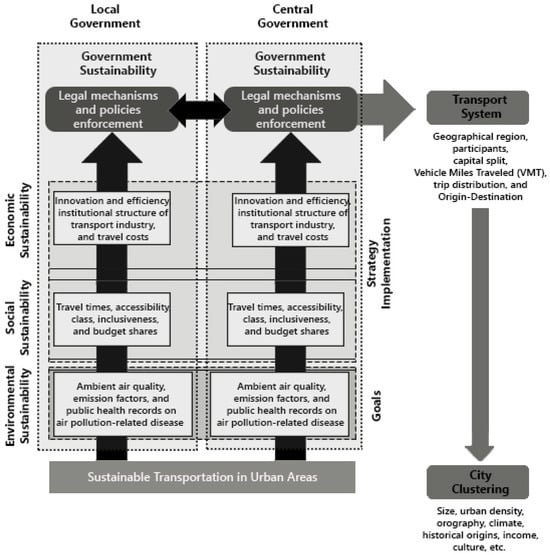
Figure 1.
Sustainable mobility through comprehensive transportation strategies in urban context. Author’s interpretation of [].
According to the Kyoto Protocol and other agreements, initiatives to minimize pollutants and emissions have become the main goal in implementing sustainable mobility strategies in urban areas, especially metropolitan areas with rapid growth of transport infrastructure and services. In sustainable mobility, the common goals are incorporated into the environmental pillar, which is translated into three indicators: ambient air quality, emission factors, and public health records on air pollution-related disease [].
The strategy implementation of sustainable mobility also incorporates the pillars of social and economic sustainability, as well as government sustainability. In the social sustainability pillar, pollution and emission reduction strategies refer to indicators of travel times, accessibility, social class, inclusiveness, and budget shares []. Meanwhile, the pillar of economic sustainability refers to three indicators, including innovation and efficiency, the institutional structure of the transport industry, and travel costs, which are classified into two categories, consisting of transport expenses in national accounts and fare and fuel prices. Various strategic indicators in these three pillars should be accommodated by the government sustainability pillar, which serves as the primary pillar (Figure 1). This effort covers legal mechanisms and policies for enforcing the flow of public and private resources into sustainable transportation. Ref. [] divides this mechanism into five strategies: coherence and complementarity between planning documents, short- and medium-term planning within a long-term road map, development of a multidisciplinary planning team, collaborative planning practices, and continuous monitoring and evaluation. These five strategies are grouped into two levels of government administration, i.e., local and central, with a reversible relationship in their development of policies and regulations [].
The implementation of transportation strategies toward sustainable mobilities varies among countries due to differences in perspectives, approaches, priorities, and interpretations []. Several strategies that are normally applied by many countries include (a) integrating land use and transportation systems; (b) improving transit, pedestrian, and cycling facilities; (c) restrictions on the use of private vehicles and the application of capital shifting; (d) integration of mass public transportation systems; (e) actor collaboration at the policy and evaluation levels; (f) determining fair and affordable fees; (g) use of technology; and (h) utilization of eco-friendly transportation modes [,,].
3. TOD as a Transport Strategy for Sustainable Mobility: Energy Saving and Emission Reduction
Transit-oriented development (TOD) emerges to cope with global urban issues such as sporadic and uncontrolled land use, inefficient mobility, and various environmental issues triggered by transportation []. One of the most highlighted problems is the level of energy consumption, air pollution, and emissions caused by unorganized and sporadic mobility in urban areas following the rapid urbanization []. Ref. [] describes that the TOD concept, in this regard, aims to limit the use of private automobiles to reduce greenhouse gas (GHG) emissions and life-cycle energy consumption by 9–25%. This finding supports [], who claimed TOD and its following strategies have considerable potential for intervention in both land uses, transport engineering, and socio-economic programs to promote urban sustainability. This argument is categorized into five elements: density, diversity, design, destination accessibility, and distance to transit, commonly known as the 5D (density, diversity, design, distance, and destination) principles of sustainable mobility [].
According to the 5D principles of sustainable mobility, TOD is proposed by designing an integrated mass public transportation system that is also connected to the spatial mixed-use design in order to achieve ease of accessibility and distance efficiency from the first to the last mile []. TOD buildings, roads, and public transport networks and designs are intended to improve efficiency, which correlates with reducing travel times and costs, decreasing reliance on private vehicles, promoting interest in mass public transportation, walking, and cycling, and enhancing energy efficiency. At a more advanced level, the application of eco-friendly mass public transportation systems, such as MRT, LRT, BRT, and micro-mobility in numerous TOD areas not only reduces emissions and pollutants whilst conserving energy but also contributes to the energy transition.
The two most crucial elements of the 5D principles of sustainable mobility are energy efficiency and emission reduction. According to [], optimizing modal shifting in TOD areas can be accomplished by improving land efficiency within a 0–500 m radius of transit nodes, particularly rail stations []. In this context, land efficiency refers to optimizing land allocation, which further affects the emergence of mixed-use planning that integrates diverse land functions into a single area within walking distance. This will ensure energy efficiency in the form of less fuel energy needed for the daily mobility of people. However, ref. [] more specifically stated that the placement of residential and office functions near transit nodes had the biggest impact on boosting the numbers of ridership. In another context, ref. [] noted that the number of connections between transit nodes and various types of mass public transportation modes is also the main driving factor for increasing the number of riders. These assertions argue that expanding transit node connectivity to the diversity and density of land functions, as well as the types of mass public transportation modes, can promote modal shifting in TOD areas and, hence, contribute to the goal of promoting energy efficiency.
TOD strategies that relate to promoting walkability are frequently related to regulating the quality of the built environment and controlling carbon emissions [,]. Several built environment attributes that influence walkability and cycling include land use, accessibility, road network connectivity, facilities and comfort for pedestrians and cyclists, safety and security, and streetscape design []. Similar to modal shifting, accessibility and connectivity in non-motorized transport strategies refer to land efficiency strategies implemented through mixed-use planning. This concludes that land efficiency tactics play an essential role in optimizing modal shifting and non-motorized transport options. This statement also describes the flow of strategies for mitigating the impact of climate change in TOD areas in the transportation sector.
In contrast with modal shifting and non-motorized transport strategies, emission reduction is not driven solely by land efficiency strategies, but rather by a more integrated policy that covers economic, social, and governance factors. In this case, the power and stability of policies that support strengthening and equitable access by offering affordable costs and adapting social inclusion are required to optimize the usage of eco-friendly public transportation []. Affordable costs are attained by regulation of the market competitiveness of conventional and renewable energy costs, control over the old fleet that produces a significant amount of air pollution, vehicle controls, and sanctions for those contributing to emission levels on the road.
4. Materials and Methods
4.1. Study Area
This study was conducted in the TOD Jakarta that focuses on the case of Dukuh Atas along the Sudirman–Thamrin corridor (Figure 2). This area serves as a pioneer transit area with the densest level of mobility and the highest transportation network in Jakarta, engaging with millions of commuters. Jakarta’s transportation has a number of complex environmental issues, one of which is the high level of mobility and dependence on private vehicles, which has ramifications for inefficient energy consumption, as well as excessive pollutants and emissions. According to the [] report, the transportation sector accounts for 36.3% of GHG emissions in Jakarta, marking the metropolitan area as one of the most significant contributors to national air pollution.
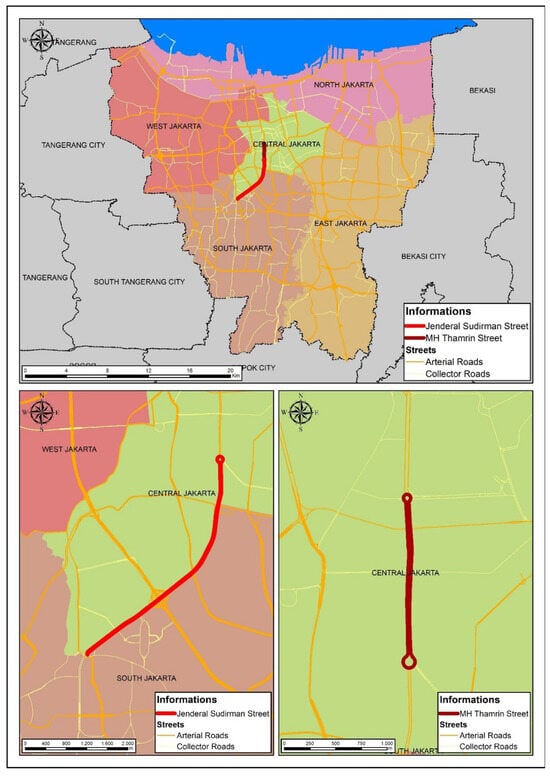
Figure 2.
Case study area.
4.2. Data Collection and Analysis
This research was conducted for 10 months, from November 2024 to August 2025, starting with field observations regarding the quality of pedestrian paths and a questionnaire survey of pedestrian volume and walking motivation in the Dukuh Atas TOD area. The pedestrian paths were selected using an accidental sampling technique, with the criteria being close to mass public transportation transit in the Dukuh Atas TOD area, including BRT stops and MRT, LRT, and commuter line stations. Based on these criteria, the observed pedestrian paths were divided into six segments (Table 1), with a radius of 350 m from the transit points. Observations of the six segments referred to intersections and traffic safety, land use attributes, street design, and surrounding land use, which were then analyzed using the PEQI method.

Table 1.
Division of pedestrian path segments in the TOD Dukuh Atas area.
Furthermore, survey respondents were selected using a purposive sampling technique, with the criteria being daily users of mass public transportation who transit in the Dukuh Atas TOD area. The number of respondents selected was 406, representing the total sample size at each transit point (Table 2). However, only 400 respondents contributed usable data since six did not correctly answer the questionnaire questions. The sample calculation used the Isaac and Michael formula, with an error value (dk) of 10%, an accuracy (d) of 0.05, and a PQ of 0.25. This sample exhibited a broad distribution of age, gender, and educational levels, as shown in Table 3.
Table 2.
Population and sample of daily users of mass public transportation in TOD Dukuh Atas.
Table 3.
Demographic distribution of the questionnaire sample.
The survey data were then analyzed using descriptive analysis, and the results were compared with (a) a literature review on traffic carbon volume and the ridership value of integrated mass public transportation, (b) a document review of supporting policies about revitalizing public transportation and implementing sustainable approaches, (c) carbon emission calculations, (d) air quality level measurements, and (e) geographic information system (GIS) spatial analysis of land use. In this study, traffic mobility volume data were obtained from the Jakarta Transportation Agency calculations on weekdays, weekends, and national holidays between 2022 and 2023. The ridership volume data were based on annual reports of the MRT, LRT, commuter line, and BRT. These data were also used in carbon emission calculations, which are explained further in the next section. Meanwhile, air quality level data corresponded to the final report on the inventory profile and greenhouse gas emission reductions for Jakarta Province in 2022 and 2023.
This research used the land use data from 2019 published by the Jakarta Provincial Government, which were previously published in 2011, to observe the land use variation in the Sudirman and Thamrin corridors. The data classification of land use in the data source subsequently focused on 4 types, namely, infrastructure, residential, office/commercial, and green open space. This research was conducted to discover the area comparison of land use types using ArcGIS 10.8 through geometric calculations provided in the tool. Furthermore, the identical calculation method was used to discover the floor area ratio of housing, the jobs-to-housing ratio, and POI density to strengthen the analysis of the existing land use in the Sudirman and Thamrin corridors. The floor area ratio was calculated based on the variety of housing types in the residential areas that exist in the Sudirman–Thamrin corridors. The jobs-to-housing ratio was calculated by comparing a variety of housing types in the residential areas and office types in office/commercial areas. The POI ratio was calculated based on the variety of commercial types in office/commercial areas.
4.3. Calculating Carbon Emissions
Quantifying carbon emissions is essential to understanding environmental performance in TOD areas. In this study, carbon emissions were calculated to estimate the emission savings resulting from the modal shifts induced by TOD interventions along Jakarta’s main corridors. The analysis followed a bottom-up activity emission approach, where total emissions were derived from the product of travel activity (vehicle distance travelled) and mode-specific emission factors. This approach is widely used in regional transport inventories and urban carbon accounting frameworks, as recommended by [,].
The emission model applied here represents a simplified version of the fuel-based approach often used in urban-scale studies, where total corridor-level emissions are calculated by multiplying vehicle activity data (vehicle counts, trip lengths, and operating days) with mode-specific EFs. The general formulation follows the Intergovernmental Panel on Climate Change (IPCC), Tier 1 guideline for transport emissions:
where is the total emissions from vehicle type , represents the activity data (VKT), and is the corresponding emission factor (gCO2 per vehicle-kilometer). To operationalize this at the corridor level, we define , where is the average daily number of vehicles, is the corridor length (km), and is the number of operating days per year. We used weekday and holiday data separately and then combined them. The complete formula becomes
where denotes annual emissions (kgCO2/year), and the division by 1000 converts grams into kilograms.
To ensure dimensional consistency, all emission coefficients were expressed in grams of CO2 per vehicle-kilometer (gCO2/vkm). Due to data and scope limitations, this study applied emission factors based on the dominant fuel types used by each vehicle category. Buses were assumed to operate on diesel fuel, while passenger cars and motorcycles predominantly used gasoline. Fuel-based CO2 emission factors were derived from [], expressed as 3.168 kg CO2/kg fuel for gasoline and 3.180 kg CO2/kg fuel for diesel. These values were converted into 2344 g CO2/L (gasoline) and 2671 g CO2/L (diesel) using standard fuel densities and then multiplied by typical fuel consumption values (L/km) for each vehicle type to obtain the vehicle-specific emission factors used in this study. The emission factors used in this study are summarized in Table 4. To assess the robustness of the calculations, deterministic sensitivity tests were performed by varying the emission factors by ±10% and the vehicle counts by ±5%.
Table 4.
Emission factors and adjustments used in this study.
The above formulation required the estimation of annual vehicle activity (VKT) for each mode, which is detailed in Section 4.4.
4.4. Annualization of Traffic Volume and Emissions
To estimate annual carbon emissions, the observed traffic volume data were converted into yearly vehicle-kilometer values based on average weekday, weekend, and public holiday conditions (Table 5). Public holiday vehicle counts were weighted accordingly to capture variations in travel demand and mode share. While seasonal fluctuations and special events were not explicitly modeled due to data limitations, the method provides a representative annualized estimation of corridor-level emissions.
Table 5.
Day-type classification and weighting applied in annualization.
The vehicle-kilometers traveled (VKT) metric represents the total distance traveled by all vehicles of type i over a given period and forms the activity basis for emission estimation following []. The annual VKT for each vehicle category was computed as
where is the average number of vehicles of type i on day typed (weekday, weekend, and holiday), L is the corridor length (km), and Dd is the number of days per category in a year based on the Jakarta Calendar in 2022 and 2023. The total annual emissions were then derived as
where EFi is the emission factor (gCO2/vkm). The use of VKT provided dimensional consistency and facilitated cross-modal comparison.
5. Results and Discussion
5.1. Implementation of TOD Policy Approach in Jakarta
In Jakarta, TOD has become a crucial urban-planning strategy to cope with transport-related issues, including congestion, pollution, and energy waste. In coping with these issues, various efforts have been introduced. In 2004, for example, Jakarta began to improve its mass public transportation system, starting by introducing the so-called BRT (bus rapid transit) []. A few years later, the BRT project was followed by the modernization of the commuter rail system since 2011 []. The improvement of the mass public transportation system demonstrates the government’s commitment to meeting the Sustainable Development Goals (SDGs), which are incorporated into the National Development Plan in accordance with Presidential Decree No. 59 (2017). This expansion of the commuter rail network was followed by the launch of the Mass Rapid Transit Jakarta (MRTJ) metro line in 2019, followed by the Jabodetabek LRT, which commenced operations in 2023 [], as described in more detail in Figure 3.
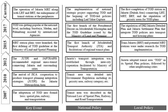
Figure 3.
The chronology of Jakarta Metropolitan TOD [].
In addition, the Jakarta Provincial Government also encourages governmental strategy to achieve net-zero emissions (NZE) by 2050, with a particular focus on the transportation sector. The programs launched in 2012 [] comprise the use of low-emission energy sources, such as the installation of solar panels on the roofs of government buildings, public facilities (schools, health services, hospitals, and sports complexes), and private buildings. Furthermore, the government has set ambitious targets for the improvement of public transportation services. The government is working toward reaching 90% coverage by 2022 while also integrating these services with various transportation modes. They assume a significant revitalization effort, which includes upgrading 346 km of pedestrian paths and 103.5 km of dedicated cycling lanes []. In line with the sustainability objectives, there is a plan to have BRT operate with 50% electric energy by 2025 []. The government has also initiated several programs aimed at improving the environmental sustainability of the city. In terms of land use, this initiative operates by implementing high-density mixed-use designs and increasing the availability of green open space (GOS) areas, with an ambitious target of 30% by 2030.
5.2. Mass Public Transport Revitalization and Sustainable Approaches
Alongside network integration, enhancements to the mass public transportation system have aimed at reducing emissions and saving energy, also leading to the quality improvement of facilities, including the expansion of corridor coverage, utilizing electrical energy, design modifications to accommodate vulnerable groups, and green station development. The BRT corridor’s coverage has been expanded to 394.4 km, comprising 188 routes, of which 3 are operated by 30 electric buses, including low-entry, medium-low-entry, and high-floor BRT buses. The Sudirman–Thamrin corridor is the main segment of the two existing routes: Bundaran Senayan–Terminal Senen (1P) and Blok M–Tanah Abang (1N). The operation of these electric modes is also supported by the provision of charging stations and depots with capacities of 200 kWh per station and 324 kWh, respectively. Based on the literature review in [], these buses are classified as low-entry, with level access from the door to the passenger seating area. Further reviews in [,] found that PT Transjakarta collaborated with the Jakarta Transportation Agency to ensure gender-responsive and inclusive amenities on the electric bus fleet, including buses with level-access doors (low entrance) measuring 1300 mm in width. Moreover, the inclusive design is also represented through the provision of (a) door sensors to detect objects trapped inside, (b) emergency levers for manual door operation, and (c) dedicated areas for wheelchair users with foldable chairs. The BRT has 33 seats, with 31 regular seats and 2 folding seats in the wheelchair area, each of which is equipped with a backrest, armrest, and seat belt. Meanwhile, priority seats are near the middle entrance, designated with a specific color (red) and information stickers stating the purpose of the seat for priority groups (Figure 4). The BRT also includes a folding ramp at the middle entrance for wheelchair users or caregivers with strollers, an LED display screen to notify the kind of route and stop, and an information board documenting the service’s whole route [,].

Figure 4.
The inclusive–ergonomic design of BRT (A) mode and (B) station [].
The inclusive–ergonomic design is also adopted by rail-based modes (e.g., MRT, LRT, and commuter line), as seen in Figure 5, besides green station design. Mas rapid transit (MRT) operations utilize two main energy sources: electricity and fuel oil. Electricity is used to power trains and support activities at stations, the depot, and the head office, while fuel oil is used as an energy source for operational vehicles. The electricity consumed by MRT trains in 2022 was 18,430,570 kWh, which climbed to 20,675,100 kWh in 2023, with the energy usage intensity in each year being 2.7182 kWh/person and 1.8163 kWh/person [,]. This condition was the outcome of using the Internet of Things (IoT) technology on the MRT system to monitor and manage energy consumption based on occupancy levels. However, PT MRT has made efforts to improve energy efficiency in station operations, such as using energy-saving light-emitting diode (LED) lights and grouping station lighting modes between elevated and underground stations. Elevated stations use 50% during the day and 100% at night, while underground stations use 100% during operating hours. This energy efficiency is also applied to toilet lights that employ human movement sensors and train modes that use just half of the electricity while stationary.
The commuter line mode reduces emissions and saves energy by employing electrical energy in trains and providing a maximum car capacity of 162 people per car, which can transport 1296–1944 passengers in a single journey using 8–12 trains each series [,]. Each car is 20 m × 2.9 m × 2.5 m, with four sliding pocket doors, three standard seats, and two priority seats per side. Regular seats can accommodate eight passengers, while priority seats can hold up to three passengers. To support the optimization of this mode, PT Kereta Commuter Indonesia (KCI) is making improvements by simplifying routes, eliminating the express commuter line, renaming the economy-AC commuter line to commuter line trains, as well as modifying, renovating, and sterilizing train facilities, stations, and tracks. One aspect of this renovation is the provision of two women-only cars at both ends of the train, with the goal of meeting the demand for women’s inclusion.

Figure 5.
The inclusive–ergonomic design of (A) MRT station [], (B) LRT station, and (C) LRT car [].
5.3. Walking Activity in TOD Dukuh Atas Along Sudirman–Thamrin Corridor
Descriptive analysis revealed that users of mass public transportation who transit in the Dukuh Atas TOD area prefer not to walk when going to their destination or vice versa. This was proven by the high percentage of pedestrians, which was only 37.25% or half of the total non-pedestrians (62.75%), as seen in Table 6. In total, 75.19% of those had a workplace as their destination, with health (44.31%) being the most important motivating factor, followed by cost (14.09%). Meanwhile, just 7.38% of them chose good accessibility as the main motivating factor, even though this factor is an important aspect in TOD implementation (Table 7).
Table 6.
Number of pedestrians in TOD Dukuh Atas.
Table 7.
Pedestrians’ motivations and destinations in TOD Dukuh Atas.
Despite the low connectivity factor percentage, the PEQI analysis showed that the quality of pedestrian paths in the transit area was good, with an average value of 80.59. Table 8 shows that the greatest values are in subsegments A1 (Bundaran HI—Grand Indonesia) and E1 (Pantai Jenderal Sudirman—Menara Astra). In this case, subsegment A1 has the largest dimension (9 m) and is completed with buffers to separate the pedestrian path from the roadway. Lighting, chairs, trash cans, and vegetation are available. However, this vegetation does not provide optimal shade for pedestrians from the sun and rain. Subsegment E1, similar to subsegment A1, has an adequate width and a smooth surface without any impediments that could interfere with pedestrian comfort. The vegetation along this subsegment is extensive, creating a cooler and more comfortable environment. There are plenty of public amenities, such as benches and garbage cans. In terms of safety and aesthetics, this subsegment is in decent shape, with enough streetlights and clean surroundings. However, traffic noise remains an issue that requires attention. Overall, the evaluations of walkability and safety in subsegment E1 were positive, resulting in a pleasant walking experience.
Table 8.
PEQI scores of pedestrian paths in TOD Dukuh Atas.
In contrast with the A1 and E1 subsegments, the PEQI calculation findings show that subsegments F1 (Kendal Street—in front of Kudus Street) and F2 (in front of Kudus Street—North Korean Embassy) had low scores of 62.80 and 59.84, respectively (Table 8). The PEQI scores for subsegment F1 showed various issues in supporting pedestrian comfort. The pedestrian path in this subsegment is small and badly surfaced, with numerous obstacles preventing pedestrian access. This subsegment has little street greenery, although there are some public amenities accessible, such as benches and trash cans. In terms of safety and aesthetics, this segment is at a lower level compared with other segments, primarily due to the presence of illegal graffiti. Although street lighting is still adequate, cleanliness is a major concern, particularly in areas used as dumping grounds, which reduces pedestrian comfort. Overall, this subsegment requires significant improvements in pedestrian path conditions, public facilities, and cleanliness to enhance walkability.
The same qualities may be observed in subsegment F2, which has limited dimensions and a high number of obstacles that hinder walking. This subsegment has very little street greenery, with only a few trees and plants, and there are no public amenities, such as seating or trash cans. This subsegment also falls short of ideal safety standards. Lighting in some locations remains inadequate, and unlawful graffiti and rubbish mounds have been discovered. These factors contribute to a decrease in the aesthetic quality and perceived safety of this category. Overall, the F2 subsegment offers a less pleasant walking experience and necessitates major improvements in sidewalk width, public facilities, safety, and cleanliness.
5.4. Modal Shifting: Change in Traffic Mobility and Ridership Volume in Sudirman–Thamrin Corridor
Modal shifting, or the transition from private vehicles to public transportation and non-motorized modes, as shown in Table 9, plays a critical role in promoting energy efficiency in Jakarta’s transport sector. In the Sudirman–Thamrin corridor, for example, a key area within Jakarta’s central business district, the shift from motorcycles and private cars to BRT and MRT can be seen from the higher percentage of public transport from 2022 to 2023, especially during weekdays. This situation demonstrates how integrated transit systems can significantly reduce energy consumption and greenhouse gas emissions from the viewpoint of modal shifting.
Table 9.
Traffic mobility volume on weekdays and weekends in Sudirman–Thamrin corridor in 2022–2023.
Private vehicles, particularly motorcycles and cars, dominate Jakarta’s roads, contributing to severe congestion and high energy consumption due to their reliance on fossil fuels. Modal shifting to public transit, such as the Transjakarta BRT and Jakarta MRT, reduces the number of individual vehicles on the road, allowing traffic congestion to be minimized and its impacts on energy consumption to be lowered. Public transport systems are inherently more energy-efficient, as they accommodate large passenger volumes per trip. This efficiency reduces fuel consumption per capita and lowers the carbon footprint of urban transport. The Sudirman–Thamrin corridor has benefited from significant investments in BRT and MRT infrastructure, making public transport a viable alternative. Transjakarta’s BRT system, with its dedicated lanes, ensures faster and more reliable service compared with private vehicles caught in traffic. Similarly, the MRT, powered by electricity, provides a sustainable transport option with reduced reliance on fossil fuels. The corridor’s integrated public transport network encourages commuters to switch from motorcycles and cars, directly contributing to energy savings.
The Sudirman–Thamrin corridor in Jakarta represents a hub of integrated mass public transport, encompassing the MRT, LRT, commuter line, and BRT systems. The ridership volumes for 2022–2023 highlight a significant increase, with MRT, LRT, and BRT showing notable growth, while the commuter line continues to attract a large share of passengers. This increase in public transport ridership aligns with Jakarta’s efforts to reduce traffic congestion and emissions, as shifting from private vehicles to public transport is a key strategy for mitigating urban pollution (see Table 10).
Table 10.
Ridership volume of integrated mass public transport network in Sudirman–Thamrin corridor in 2022–2023 [,,,,,,].
Table 10.
Ridership volume of integrated mass public transport network in Sudirman–Thamrin corridor in 2022–2023 [,,,,,,].
| Year | MRT | LRT | Commuter Line | BRT | ||||
|---|---|---|---|---|---|---|---|---|
| Persons | % | Persons | % | Persons | % | Persons | % | |
| 2022 | 9000 | 6.00 | - | - | 20,331 | 13.55 | 120,690 | 80.45 |
| 2023 | 15,167 | 4.73 | 20,800 | 6.49 | 30,871 | 9.63 | 253,845 | 79.15 |
Public transport is inherently more energy-efficient than private vehicles due to its capacity to move larger numbers of people with fewer resources. In 2023, the BRT recorded an impressive 1.1 million riders, an increase from 523,000 in 2022, contributing significantly to reducing the number of private cars and motorcycles on the road. Similarly, the MRT and the newly operational LRT attracted 169,128 and 41,598 riders, respectively. These shifts reduce fuel consumption and emissions, as public transport systems like BRT and MRT operate with lower energy use per passenger-kilometer compared with private vehicles.
The integration of various public transport modes in the Sudirman–Thamrin corridor enhances accessibility and convenience, encouraging modal shifting. Commuters can seamlessly transfer between MRT, LRT, and BRT, reducing the reliance on private vehicles for intercity and intracity travel. For example, the increase in commuter line usage from 627,495 in 2022 to 952,595 in 2023 demonstrates the impact of improved connectivity. This integration not only optimizes public transport capacity but also contributes to lowering carbon dioxide (CO2) emissions by consolidating travel into fewer, more efficient vehicles.
The MRT and BRT systems stand out as key contributors to emission reduction. The MRT operates on electricity, avoiding direct emissions associated with internal combustion engines. In 2023, the increase in MRT ridership to 169,128 passengers highlights its growing role in reducing emissions. BRT buses, particularly the newer electric and low-emission models, further enhance environmental benefits. These systems replace thousands of individual car trips, reducing greenhouse gas emissions and particulate matter, which are major contributors to air pollution in Jakarta. Although the LRT only became operational in 2023, with a modest ridership of 41,598, its potential for emission reduction is significant. The LRT complements the MRT by providing additional low-emission transport options for specific routes. Over time, as ridership increases and integration with other modes improves, the LRT is expected to play a larger role in the city’s overall sustainability strategy, further reducing the dependency on private vehicles.
Increased public transport usage contributes to reducing urban congestion, which indirectly decreases emissions. Idle vehicles stuck in traffic consume more fuel and emit more pollutants. By shifting riders to efficient public transport, the Sudirman–Thamrin corridor reduces these congestion-related emissions. Moreover, fewer vehicles on the road lead to less noise pollution and improved air quality, enhancing urban living conditions and public health outcomes. The ridership growth across the MRT, LRT, commuter line, and BRT in Jakarta’s Sudirman–Thamrin corridor illustrates the environmental benefits of investing in integrated public transport systems. These modes collectively offer sustainable alternatives to private vehicle use, significantly contributing to emission reduction. As the city continues to expand its public transport network and adopt greener technologies, Jakarta sets an example for urban centers worldwide in using modal shifting to combat climate change and improve urban sustainability.
5.5. Impact of TOD Implementation on Land Use of Sudirman–Thamrin Corridor
This section presents the analysis of land use in two road segments, Sudirman and Thamrin, categorized into four key areas: residential, offices/commercial, infrastructure, and GOS (Table 11). Regarding the land use distribution within a 500 m radius of the Sudirman corridor (Figure 6), the largest portion of the area is dedicated to offices and commercial purposes, accounting for 178.87 hectares (36%). This highlights the corridor’s primary role as a commercial and business hub, likely reflecting high demand for office spaces and retail establishments. Residential spaces occupy 154.42 hectares (31%), forming a significant portion of the area. Green open spaces make up 87.40 hectares (18%), which is substantial for a dense urban corridor. Infrastructure, covering 71.33 hectares (14%), reflects the necessity of roads, public facilities, and utilities to support the area’s dense residential and commercial activities.
Table 11.
Land use in the Sudirman–Thamrin corridor.
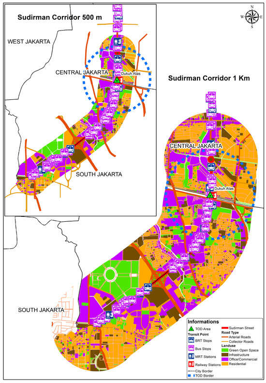
Figure 6.
The land use of the Sudirman corridor at 500 m and 1 km.
In the Sudirman corridor, within a 1 km radius, the land use distribution reveals a notable concentration of various functions. Residential areas occupy the largest share, covering 443.63 hectares, which constitutes 41% of the total land use in the area. This is followed by offices and commercial spaces, which together account for 313.06 hectares or 29% of the land. Infrastructure, including roads, utilities, and other essential facilities, represents 152.11 hectares, amounting to 14% of the land area. Finally, green open spaces, such as parks and recreational areas, cover 174.61 hectares, or 16%, providing important environmental and social benefits in this urban context.
This distribution highlights the mixed-use nature of the Sudirman corridor, balancing residential, commercial, and infrastructural needs with significant green space in an urban setting. The balance between residential and commercial zones suggests mixed-use development, possibly to support urban living and reduce commuting distances for workers. The allocation of GOS indicates a focus on urban livability, environmental sustainability, and providing recreational areas for residents and workers. A relatively smaller share for infrastructure could point to efficient land use or potential congestion challenges in this urban corridor.
In the MH-Thamrin corridor in a radius of 500 m (Figure 7), offices and commercial spaces account for 81.92 hectares (37%), making it the largest land use category. This reflects Thamrin’s primary role as a bustling economic hub with a focus on business, retail, and commercial activities. Infrastructure occupies 64.66 hectares (29%), indicating a significant focus on roads, public utilities, and transit systems. Residential zones cover 63.41 hectares (28%), indicating a near balance with infrastructure. Green spaces account for only 12.57 hectares (6%), the smallest category. In the 1 km radius, residential land use has expanded to 196.27 hectares (35%), which is almost three times the residential area in the 500 m radius (63.41 hectares or 28%). This expansion indicates more space dedicated to housing in the broader area. The commercial area in the 1 km radius is 164.65 hectares (29%), down from 36% in the 500 m radius. This reduction suggests that, in the broader area, commercial development is slightly less concentrated compared with the immediate corridor. Infrastructure in the 1 km radius is 162.62 hectares (29%), which is a significant increase compared with the 14% in the 500 m radius. The broader area requires more infrastructure to support commercial activity and also reflects increased roads, utilities, and public transport networks aimed at linking different parts of the city. Green open space increased to 40.27 hectares (7%) in the 1 km radius, up from 6% in the 500 m radius.
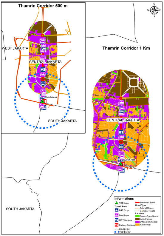
Figure 7.
The land use of the Thamrin corridor at 500 m and 1 km.
The emphasis on infrastructure supports accessibility and mobility, but also may contribute to urban heat islands and emissions from vehicle use. Heavy reliance on motorized transportation could exacerbate traffic congestion and air pollution. The lack of green open spaces can lead to increased energy demand for cooling and reduced carbon sequestration capacity. The Thamrin corridor’s land use distribution highlights its role as a commercial hub supported by robust infrastructure and residential areas. However, the lack of green spaces presents a challenge for sustainable urban development. Energy-saving initiatives, improved public transportation, and enhanced greenery could significantly reduce emissions while maintaining the area’s economic and functional vitality.
This section also determined the floor area ratio of the residential areas in the Sudirman–Thamrin corridors as part of the land use analysis conducted previously, categorized into three types, namely, low-floor housing, medium-high-floor housing, and vertical housing (Table 12). Regarding the floor area ratio of the Sudirman corridor (Figure 8), the largest portion of the area was dedicated to medium-high-floor housing, accounting for 369.33 hectares (78.94%), while vertical housing accounted for 97.65 hectares (20.88%), and low-floor housing accounted for only 0.86 hectares (0.18%). With a ratio of 0.35, this indicates that medium-high-floor housing plays an important role in supporting housing needs in the corridor’s primary role as a commercial and business hub.
Table 12.
Floor area ratio in Sudirman–Thamrin corridor.
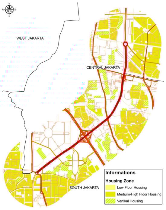
Figure 8.
Floor area ratio in Sudirman corridor.
The floor area ratio of the Thamrin corridor (Figure 9) indicates that the largest portion of the area is also dedicated to medium-high-floor housing, accounting for 150.65 hectares (90%), while vertical housing accounted for 17.45 hectares (10%), with no low-floor housing. This result also indicates that medium-high-floor housing in the Thamrin corridor plays an important role in supporting housing needs for commercial and business hubs. The low amount of vertical housing in the Sudirman–Thamrin corridor is caused by the high building cost of vertical housing and the high land value in the surrounding area of the Sudirman–Thamrin corridor for housing developers to build new vertical housing areas. It also affects the calculations of vertical housing developers in terms of business profits.
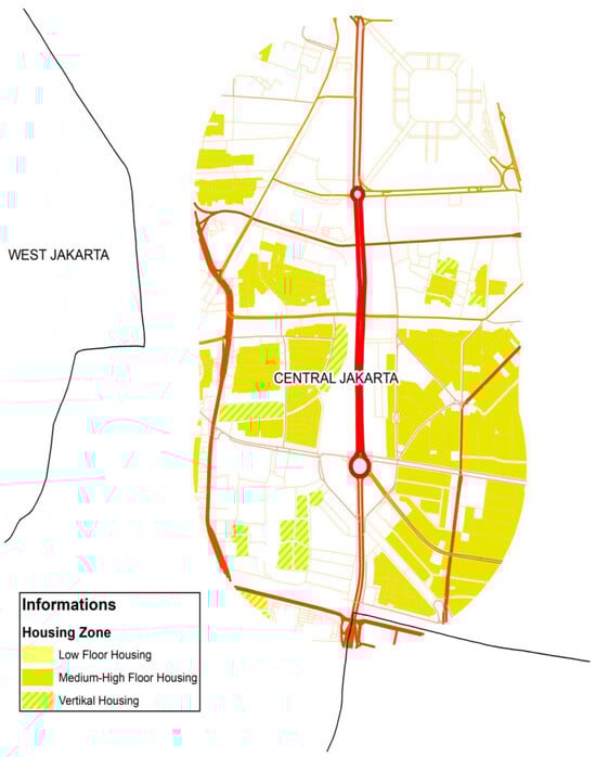
Figure 9.
Floor area ratio in Thamrin corridor.
In terms of the jobs-to-housing ratio in the Sudirman–Thamrin corridors, the result was determined by comparing the ratio between the office area and housing area (Table 13). The jobs-to-housing ratio of the Sudirman corridor is shown in Figure 10. The largest portion of the area was dedicated to housing, accounting for 443.63 hectares (66%), while offices accounted for 229.16 hectares (34%). The ratio of housing in the Sudirman corridor showed a higher number than the office ratio, with a comparison between 0.33 and 0.17. These values indicate that the housing provided in the Sudirman corridor is sufficient to support office activities.
Table 13.
Jobs-to-housing ratio in Sudirman–Thamrin corridor.

Figure 10.
Jobs-to-housing ratio in the Sudirman corridor.
The jobs-to-housing ratio of the Thamrin corridor showed a similar result to the Sudirman corridor (Figure 11). The largest portion of the area was dedicated to housing, accounting for 196.27 hectares (61%), while offices accounted for 127.84 hectares (39%). The ratio of housing in the Thamrin corridor also showed a greater number than the office ratio, with a comparison between 0.29 and 0.19. These values also indicate that housing in the Thamrin corridor plays an important role in supporting office activities.

Figure 11.
Jobs-to-housing ratio in the Thamrin corridor.
In terms of the POI ratio in the Sudirman–Thamrin corridor (Table 14), this research discovered 14 major types in both corridors. The Sudirman corridor was dominated by 89 stores, 73 hotels, 49 restaurants, and 22 culinary spots. These results indicate that most of the existing POIs exist to support office and business-related activities. There were also minor activities, such as bars, billiards, cafés, and sports arenas, which are also places where people can carry out activities after work hours. The Thamrin corridor was also dominated by 55 stores, 66 hotels, 48 restaurants, and 11 culinary spots. These results also indicate that most POIs support office and business-related activities. Minor activities, namely, cafés, sports halls and fields, minimarkets, and malls, have become a choice that does not have much impact on the lives of working people in carrying out activities after work hours.
Table 14.
Point-of-interest ratio in Sudirman–Thamrin corridor.
5.6. Impact of TOD Implementation Strategies on Air Quality and Carbon Emissions Levels
Emissions from vehicles are the main contributor to air pollution in Jakarta, Indonesia. The transportation sector is responsible for significant emissions, with NOx (nitrogen oxide), CO (carbon monoxide), PM10 (particulate matter 10), and PM2.5 (particulate matter 2.5), accounting for 72.4%, 92.36%, 57.99%, and 67.03%, respectively (see Table 15) []. The high level of private vehicle ownership is one of the factors contributing to high emissions from the transportation sector. In this case, ref. [] conducted a study using scenario analysis with four approaches, including (1) a business-as-usual scenario, (2) a government program and policy intervention, (3) electrification and renewable energy use, and (4) toward-2050 NZE scenarios. The business-as-usual scenario maintained the status quo, reflecting no changes and in line with current trends. The government program and policy intervention scenario was driven by policies and targets established by both the provincial and national governments. The electrification and renewable energy use scenarios embraced assumptions in line with targets set by international institutions that were relatively more ambitious than the previous scenarios []. The toward-NZE scenario proposed more ambitious and progressive assumptions to reduce emissions to a minimum or near-zero levels.
Table 15.
Air quality level in Sudirman–Thamrin corridor [,].
Compared with the national air quality standards, which are stated in Government Regulation Number 22 of 2021, the results in Table 10 show that the main contributors were private cars and motorcycles, accounting for 36% and 47% of the emissions, respectively. Associated with that, if the government implemented policy programs and promoted changes in public behavior, there was an estimated reduction of 4.5 million tons of carbon dioxide equivalents (CO2e) compared with emission levels in 2020. This reduction was driven by a combination of technological advancements and shifts in people’s mobility behavior, including a greater reliance on public transportation and a preference for walking or cycling for shorter distances. Furthermore, emission reductions were also achieved through the transition to renewable energy using electric vehicles in line with the 2030 energy mix target.
The emission estimation results reveal substantial differences in total corridor emissions between locations and years, reflecting both spatial and temporal variations in travel behavior and vehicle activity (Table 16). In 2023, the Sudirman corridor generated approximately 3.27 × 10⁹ kg CO2/year, dominated by private cars (around 96% of total emissions), followed by buses and motorcycles. The Thamrin corridor, which experienced a modal shift and operational restructuring after TOD implementation, recorded lower total emissions of 6.9 × 10⁷ kg CO2/year in 2022 and 8.0 × 10⁷ kg CO2/year in 2023, despite an increase in public transport ridership. This suggests that improved accessibility and density near transit nodes may have reduced trip distances and private vehicle dependence, partially offsetting the energy demand associated with higher passenger throughput.
Table 16.
Carbon emission levels from traffic in Sudirman–Thamrin corridor.
A sensitivity analysis was conducted to evaluate the robustness of emission estimates to variations in key input parameters (Table 17). The results indicate that a ±10% change in the emission factor and a ±5% change in vehicle activity (VKT) resulted in nearly proportional changes in total corridor emissions, ranging from −11% to +9% relative to the baseline. When both parameters were increased simultaneously (EF + 10% and VKT + 5%), total emissions increased by approximately 18%, indicating a compounding effect between vehicle energy intensity and traffic volume. These results confirm that the emission model behaves linearly and remains stable within a realistic uncertainty range, consistent with the ±10–20% uncertainty range recommended by [,] for urban road transport.
Table 17.
Sensitivity scenarios and changes in total corridor emissions.
In addition to model validation, the sensitivity results also provide insights into the underlying behavioral and efficiency dynamics of urban mobility. Variations in VKT reflect potential changes in travel demand and mode choice, such as greater reliance on private vehicles during periods of economic recovery or reduced travel during restrictions. Similarly, changes in the EF indicate shifts in vehicle energy efficiency, congestion intensity, or fuel quality. The proportional response of total emissions to these two parameters indicates that emission reductions in Jakarta’s TOD corridors depend jointly on technological improvements and sustainable behavioral changes toward high-capacity, low-emission modes. These findings highlight the importance of integrating travel behavior and energy efficiency measures into future sustainable mobility strategies for large cities with dense traffic conditions like Jakarta.
From the perspective of sustainable mobility, the results support the hypothesis that transit-oriented development (TOD) can contribute to energy savings and emission reductions through compact land use and enhanced public transport utilization. Although total emissions remained dominated by private motorized modes, the increasing share of buses and the decline in motorcycle use indicate a gradual modal shift toward higher-capacity, lower-emission transport systems. Combined with the sensitivity analysis, which confirmed the robustness of the model under moderate variations in emission factors and traffic volumes, these findings suggest that the observed emission reductions in TOD corridors are both meaningful and methodologically reliable.
Nevertheless, these results should be interpreted as associative rather than strictly causal, as several concurrent external factors, such as fluctuations in fuel prices, post-pandemic economic recovery, the expansion of ride-hailing services, and the implementation of other transport policies, may also have influenced mobility patterns. These overlapping dynamics make it difficult to isolate the specific contribution of TOD interventions from broader socio-economic and behavioral changes. To strengthen causal inference, future research should incorporate comparative analyses using non-TOD or pre-TOD control corridors and apply panel or difference-in-differences (DID) models to account for time-varying external influences. Such approaches would allow for a more precise estimation of TOD-induced effects on both emission and energy outcomes.
6. Conclusions
The land use analysis of the Sudirman and Thamrin corridors revealed a mixed-use urban structure, balancing residential, commercial, infrastructure, and GOS. Sudirman shows a stronger presence of residential land (41% within 1 km), supported by significant commercial activity and relatively higher GOS (16–18%), promoting urban livability and sustainability. Thamrin, in contrast, is more commercially intensive, with limited GOS (6–7%) and a heavy emphasis on infrastructure, raising concerns about environmental sustainability.
Both corridors rely heavily on medium-high-floor housing, reflecting an efficient response to dense urban demands, while vertical housing remains limited. The job-to-housing ratio in Sudirman suggests adequate residential provision to support its business functions, reducing commuting needs. The point-of-interest (POI) analysis reinforced the business orientation of both corridors, with a high concentration of stores, hotels, and restaurants catering to office workers, along with limited recreational options for after-work activities. To support sustainable development, future planning should enhance green space, promote vertical housing, and diversify amenities to balance work–life needs in Jakarta’s core commercial zones.
The adoption of TOD in the Sudirman–Thamrin corridor has had a generally positive impact on modal shifting, which has implications for emission reductions, while energy savings cannot be concluded. The achievement of this modal shifting illustrates the outcome of the government’s efforts to improve the mass public transportation system, which is accomplished not only through integration but also through a variety of types of availability, coverage, affordable fares, and inclusive design. This has led to the dominance of BRT users compared with rail mode users. In this case, rail modes, particularly MRT and LRT, have higher fares and restricted coverage. Nevertheless, the rail mode possesses a higher capacity; therefore, its predominant utilization could lead to more substantial emission reductions. Moreover, the characteristics of population mobility are intricately linked to the Global South, indicating that the utilization of rail transport holds greater potential for mitigating emissions and conserving energy. With the same context of the TOD policy approach, the strategy for reducing emissions and saving energy in Jakarta’s transit zones may involve implementing train fare subsidies, similar to the strategy utilized in Bangkok, Thailand.
In particular, the shift toward more sustainable transportation modes—such as public transit, walking, and cycling—combined with the deployment of electric vehicles and improved urban planning (e.g., TOD implementation), has already shown measurable impacts. For instance, corridors like Thamrin have experienced a decline in total emissions despite increased ridership, highlighting the effectiveness of integrated transit policies in curbing emissions.
Sensitivity analysis revealed that emissions were moderately affected by changes in EFs and traffic volume (VKT), with combined increases leading to an 18% rise in total emissions. This highlights the need for accurate modeling and comprehensive strategies that address both technology and mobility behavior. Achieving Jakarta’s 2050 Net-Zero Emissions goal will require integrated, adaptive policies focused on sustainable transport and energy use.
Importantly, the findings of this study should be interpreted as associative, rather than purely causal. The observed emission reductions and modal shift along the Sudirman–Thamrin corridor are likely influenced by external factors such as fuel price fluctuations, post-pandemic economic recovery, teleworking trends, and the expansion of online transportation services. These concurrent dynamics limit the ability to isolate TOD interventions as the sole driver of change.
Despite these limitations, evidence suggests that TOD implementation, when combined with transport affordability, multimodal integration, and supportive land use policies, can contribute significantly to reducing transport emissions at the corridor level. To strengthen causal understanding, future research should incorporate non-TOD or pre-TOD comparison corridors, use a panel or difference-in-differences (DID) approach, and assess multi-year behavioral responses. Such an approach would allow for clearer attribution of TOD’s impact on emissions reductions and energy efficiency in Jakarta and similar megacities.
Author Contributions
Conceptualization, H.S.H. and C.T.P.; methodology, H.S.H., B.N.E., F.W.A., R.H. and D.P.P.; formal analysis, H.S.H., C.T.P., B.N.E., F.W.A., R.H. and D.P.P.; investigation, B.N.E., F.W.A., R.H. and D.P.P.; resources, B.N.E., F.W.A., R.H. and D.P.P.; data curation, H.S.H., C.T.P., B.N.E., F.W.A., R.H. and D.P.P.; writing—original draft preparation, H.S.H., C.T.P., B.N.E., F.W.A. and R.H.; writing—review and editing, H.S.H., B.N.E. and F.W.A.; visualization, B.N.E. and R.H.; supervision, H.S.H.; project administration, H.S.H.; funding acquisition, H.S.H. All authors have read and agreed to the published version of the manuscript.
Funding
This research was funded by the 2025 Regular Fundamental Research Grant from the Ministry of Higher Education, Science, and Technology (grant number: 070/C3/DT.05.00/PL/2025) (Master Contract Number) and PKS-481/UN2.RST/HKP05.00/2025 (Derivative Contract Number).
Institutional Review Board Statement
Not applicable.
Informed Consent Statement
Not applicable.
Data Availability Statement
The data presented in this study are available upon request from the corresponding author.
Conflicts of Interest
The authors declare no conflicts of interest.
Abbreviations
| BRT | Bus Rapid Transit |
| CO | Carbon Monoxide |
| CO2 | Carbon Dioxide |
| CO2e | Carbon Dioxide Equivalent |
| DID | Difference-In-Differences |
| EF | Emission Factor |
| FAR | Floor Area Ratio |
| gCO2 | Grams of Carbon Dioxide |
| GHGs | Greenhouse Gases |
| GIS | Geographic Information System |
| GOS | Green Open Space |
| HI | Hotel Indonesia |
| IPCC | Intergovernmental Panel on Climate Change |
| Kg | Kilogram |
| Km | Kilometer |
| KWh | Kilowatt-Hour |
| L | Liter |
| LED | Light-Emitting Diode |
| LRT | Light Rail Transit |
| MRT | Mass Rapid Transit |
| MRTJ | Mass Rapid Transit Jakarta |
| MH-Thamrin | Mohammad Hoesni-Thamrin |
| NOx | Nitrogen Oxide |
| NZE | Net-Zero Emissions |
| PEQI | Pedestrian Environmental Quality Index |
| PM | Particulate Matter |
| POI | Point of Interest |
| SDGs | Sustainable Development Goals |
| TOD | Transit-Oriented Development |
| VKT | Vehicle-Kilometers Traveled |
| vkm | Vehicle-Kilometer |
| 5D | Density, Diversity, Design, Distance, and Destination |
References
- Lyu, G.; Bertolini, L.; Pfeffer, K. Developing a TOD typology for Beijing metro station areas. J. Transp. Geogr. 2016, 55, 40–50. [Google Scholar] [CrossRef]
- Conticelli, E.; Santangelo, A.; Tondelli, S. Innovations in cycling mobility for sustainable cities. In Town and Infrastructure Planning for Safety and Urban Quality; Taylor & Francis Group: New York, NY, USA, 2018. [Google Scholar] [CrossRef]
- Buehler, R.; Bakhshi, V. Cycling and Micromobility. In The Routledge Handbook of Sustainable Urban Transport; Taylor & Francis Group: New York, NY, USA, 2025. [Google Scholar] [CrossRef]
- Macioszek, E.; Jurdana, I. Bicycle traffic in the cities. Sci. J. Silesian Univ. Technol. Ser. Transp. 2022, 117, 115–127. [Google Scholar] [CrossRef]
- Ayla-Chauvin, M.I.; Maldonado-Correa, J.; Samaniego, C.; Sanmarti, G.R. Lifecycle assessment of electricity generation transition in Ecuador. In Lecture Notes in Electrical Engineering: Innovation in Electrical and Electronic Engineering; Springer: Berlin/Heidelberg, Germany, 2021. [Google Scholar] [CrossRef]
- Hasibuan, H.S.; Soemardi, T.P.; Koestoer, R.; Moersidik, S. The Role of Transit Oriented Development in constructing urban environment sustainability, the case of Jabodetabek, Indonesia. Procedia Environ. Sci. 2014, 20, 622–631. [Google Scholar] [CrossRef]
- Jamme, H.T.; Rodriguez, J.; Bahl, D.; Banerjee, T. A Twenty-Five-Year Biography of the TOD Concept: From Design to Policy, Planning, and Implementation. J. Plan. Educ. Res. 2019, 39, 409–428. [Google Scholar] [CrossRef]
- Liang, Y.; Du, M.; Wang, X.; Xu, X. Planning for urban life: A new approach of sustainable land use plan based on transit oriented development. Eval. Program Plan. 2020, 80, 101811. [Google Scholar] [CrossRef]
- Curtis, C.; Scheurer, J. Planning for sustainable accessibility: Developing tools to aid discussion and decision-making. Prog. Plan. 2010, 74, 53–106. [Google Scholar] [CrossRef]
- Niu, S.; Shen, Z.; Lau, S.S.Y.; Gan, X. Study on land use characteristics of rail transit TOD sites in new towns—Taking Singapore as an example. J. Asian Archit. Build. Eng. 2019, 18, 19–30. [Google Scholar] [CrossRef]
- Hasibuan, H.S.; Permana, C.T. Socio-cultural characteristics of people and the shape of transit-oriented development (TOD) in Indonesia: A mobility culture perspective. J. Transp. Land Use 2022, 15, 295–314. [Google Scholar] [CrossRef]
- Ann, S.; Yamamoto, T.; Jiang, M. Re-examination of the standards for transit oriented development influence zones in India. J. Transp. Land Use 2019, 12, 679–700. [Google Scholar] [CrossRef]
- Lang, W.; Hui, E.C.M.; Chen, T.; Li, X. Understanding livable dense urban form for social activities in transit-oriented development through human-scale measurements. Habitat Int. 2020, 104, 102238. [Google Scholar] [CrossRef]
- Pan, H.; Shen, Q.; Liu, C. Transit-oriented development at the urban periphery. Transp. Res. Rec. 2011, 1993, 95–102. [Google Scholar] [CrossRef]
- Suzuki, H.; Murakami, J.; Hong, Y.H.; Tamayose, B. Financing Transit-Oriented Development with Land Values: Adapting Land Value Capture in Developing Countries; World Bank Publications: Washington, DC, USA, 2015. [Google Scholar]
- Lyu, G.; Bertolini, L.; Pfeffer, K. How does transit-oriented development contribute to station area accessibility? A study in Beijing. Int. J. Sustain. Transp. 2020, 14, 533–543. [Google Scholar] [CrossRef]
- Wang, J.; Samsura, D.A.A.; van der Krabben, E. Institutional barriers to financing transit-oriented development in China: Analyzing informal land value capture strategies. Transp. Policy 2019, 82, 1–10. [Google Scholar] [CrossRef]
- Ibraeva, A.; de Correia, G.H.A.; Silva, C.; Antunes, A.P. Transit-oriented development: A review of research achievements and challenges. Transp. Res. Part A Policy Pract. 2020, 132, 110–130. [Google Scholar] [CrossRef]
- Pan, H.; Li, J.; Shen, Q.; Shi, C. What determines rail transit passenger volume? Implications for transit-oriented development planning. Transp. Res. Part D Transp. Environ. 2017, 57, 52–63. [Google Scholar] [CrossRef]
- Hu, X.; Chang, S.; Li, J.; Qin, Y. Energy for sustainable road transportation in China: Challenges, initiatives, and policy implications. Energy 2010, 35, 4289–4301. [Google Scholar] [CrossRef]
- Gabriel, N.R.; Martin, K.K.; Haslam, S.J.; Faile, J.C.; Kamens, R.M.; Gheewala, S.H. A comparative life cycle assessment of electric, compressed natural gas, and diesel buses in Thailand. J. Clean. Prod. 2021, 314, 128013. [Google Scholar] [CrossRef]
- Yao, S.; Budthimedhee, K. Addressing global climate challenges: Low-carbon transport planning practices and optimization strategies in Bangkok. In Proceedings of the 2024 International Conference on Environment Engineering, Urban Planning and Design (EEUPD 2024), Nanjing, China, 29 November–1 December 2024; Volume 617. [Google Scholar] [CrossRef]
- Nakamura, K.; Gu, F.; Wasuntarasook, V. Failure of Transit-Oriented Development in Bangkok from a Quality of Life Perspective. Asian Transp. Stud. 2016, 4, 194–209. [Google Scholar] [CrossRef]
- Hasibuan, H.S.; Koestoer, R.H.; Permana, C.T.; Danial, M.H.; Marzukhi, M.A.; Elizandri, B.N. The progression of transport infrastructures and Transit Oriented Development (TOD) areas in Jakarta and Kuala Lumpur suburban: Lessons from policy approach. J. Infrastruct. Policy Dev. 2024, 8, 6025. [Google Scholar] [CrossRef]
- Hasibuan, H.S.; Koestoer, R.H.; Permana, C.T.; Elizandri, B.N.; Danial, M.H.; Abdullah, J. Transport policies, transit-oriented and development redistribution of population in peri-urban: Lessons from kuala lumpur and jakarta metropolitan area. Plan. Malays. 2024, 22, 1438. [Google Scholar] [CrossRef]
- Hasibuan, H.S.; Mulyani, M. Transit-Oriented Development: Towards Achieving Sustainable Transport and Urban Development in Jakarta Metropolitan, Indonesia. Sustainability 2022, 14, 5244. [Google Scholar] [CrossRef]
- Stoddart, H.; Bottero, M.; Cornforth, J.; Dodds, F.; Lingan, J.; Schneeberger, K.; Shaw, A.; Smith, N.; Strachan, J.; White, R. Guide to Sustainable Development Governance, 2nd ed.; Commonwealth Secretariat: London, UK, 2011. [Google Scholar]
- Ben-Eli, M.U. Sustainability: Definition and five core principles, a system perspective. Sustain. Sci. 2018, 13, 1337–1343. [Google Scholar] [CrossRef]
- Prescott-Allen, R. The Wellbeing of Nation: A Country-by-Country Index of Quality of Life and the Environment; Island Press: Washington, DC, USA, 2001. [Google Scholar]
- Tournaki, S.; Farmaki, E.; Tsoutsos, T. Impact assessment of sustainable mobility in touristic cities of Europe: The civitas destinations approach on energy environment and economy. In The Role of Exergy in Energy and the Environment; Green Energy and Technology; Springer: Berlin/Heidelberg, Germany, 2018; pp. 297–309. [Google Scholar] [CrossRef]
- Consult, R. Guidelines for Developing and Implementing a Sustainable Urban Mobility Plan, 2nd ed.; Forschung and Beratung GmbH: Cologne, Germany, 2019. [Google Scholar]
- Zavadskas, E.K.; Saparauskas, J.; Kaklauskas, A.; Turskis, Z.; Vilutiene, T. Evaluation of Vilnius sustainability from social, economic, and engineering-technical poin of view using the game theory. Technol. Econ. Dev. Econ. 2010, 11, 134–143. [Google Scholar] [CrossRef]
- Federal Highway Administration. Sustainable Transportation Practices in Europe; US Department of Transportation: Washington, DC, USA, 2001.
- Tadic, S.; Krstic, M.; Roso, V.; Brnjac, N. Planning an intermodal terminal for the sustainable transport networks. Sustainability 2019, 11, 4102. [Google Scholar] [CrossRef]
- Nadi, P.A.; Murad, A.K. Modelling sustainable urban transport performance in the Jakarta City Region: A GIS approach. Sustainability 2019, 11, 1879. [Google Scholar] [CrossRef]
- Xu, W.A.; Fan, Y.; Guthrie, A.; Li, Y. Transit-oriented development in China: Literature review and evaluation of TOD potential across 50 Chinese cities. J. Transp. Land Use 2017, 10, 743–762. [Google Scholar] [CrossRef]
- Gu, P.; He, D.; Chen, Y.; Zegras, P.C.; Jiang, Y. Transit-oriented development and air quality in Chinese cities: A city level examination. Transp. Res. Part D Transp. Environ. 2019, 68, 10–25. [Google Scholar] [CrossRef]
- Ali, L.; Nawaz, A.; Shahid, I.; Basheer, M.A.; Hameed, J.; Albasher, G.; Shah, S.A.R.; Bai, Y. Dynamics of transit-oriented development, role of green house gases and urban environment: A study for management and policy. Sustainability 2021, 13, 2536. [Google Scholar] [CrossRef]
- Cervero, R.; Sullivan, C. Green TODs: Marrying Transit Oriented Development amd Green Urbanism. Int. J. Sustain. Dev. World Ecol. 2011, 18, 210–218. [Google Scholar] [CrossRef]
- Ewing, R.; Cervero, R. Travel and the Built Environment. J. Am. Plan. Assoc. 2010, 76, 265–294. [Google Scholar] [CrossRef]
- Dittmar, H.; Poticha, S. Defining Transit Oriented Development: The New Regional Building Block. In The New Transit Town: Best Practices in Transit Oriented Development; Dittmar, H., Ohlan, G., Eds.; Island Press: Washington, DC, USA, 2004; pp. 19–39. [Google Scholar]
- Berawi, M.A.; Saroji, G.; Iskandar, F.A.; Ibrahim, B.E.; Miraj, P.; Sari, M. Optimizing Land Use Allocation of Transit-Oriented Development (TOD) to Generate Maximum Ridership. Sustainability 2020, 12, 3798. [Google Scholar] [CrossRef]
- Kim, C.; Kim, S.W.; Kang, H.J.; Song, S.M. What makes urban transportation efficient? Evidence from subway transfer stations in Korea. Sustainability 2017, 9, 2054. [Google Scholar] [CrossRef]
- Schirmer, P.M.; Van Eggermond, M.A.B.; Axhausen, K.W. The role of location in residential location choice models: A review of literature. J. Transp. Land Use 2014, 7, 3–21. [Google Scholar] [CrossRef]
- Tong, X.; Wang, Y.; Chan, E.H.W.; Zhou, Q. Correlation Between Transit Oriented Development (TOD), Land Use Catchment Areas, and Local Environmental Transformation. Sustainability 2018, 10, 4622. [Google Scholar] [CrossRef]
- Mo, B.; Shen, Y.; Zhao, J. Impact of Built Environment on Firstand Last-Mile Travel Mode Choice. Transp. Res. Rec. 2018, 2672, 40–51. [Google Scholar] [CrossRef]
- Fonseca, F.; Ribeiro, P.J.G.; Conticelli, E.; Jabbari, M.; Papageorgiou, G.; Tondelli, S.; Ramos, R.A.R. Built environment attributes and their influence on walkability. Int. J. Sustain. Transp. 2022, 16, 660–679. [Google Scholar] [CrossRef]
- Ardiansyah, H.; Ekadewi, P. Pathways and recommendations on energy transition strategy to achieve Net-zero Emissions by 2060. In Indonesia Post-Pandemic Outlook: STRATEGY Towards Net-Zero Emissions by 2060 from the Renewables and Carbon-Neutral Energy Perspectives; Ardiansyah, H., Ekadewi, P., Eds.; BRIN Publishing: Jakarta, Indonesia, 2022; pp. 267–281. [Google Scholar] [CrossRef]
- Cabacungan, P.; Lazaroff, T. Inclusion: Energizing Community Networks with Bottom-Up Stakeholder Engagement; ICLEI: Jakarta, Indonesia, 2021. [Google Scholar]
- European Environment Agency (EEA). EMEP/EEA Air Pollutant Emission Inventory Guidebook 2024—Technical Guidance to Prepare National Emission Inventories; Publications Office of the European Union: Luxembourg, 2024. [Google Scholar]
- Intergovernmental Panel on Climate Change (IPCC). Chapter 3—Mobile Combustion. In 2006 IPCC Guidelines for National Greenhouse Gas Inventories, Volume 2: Energy; Eggleston, H.S., Buendia, L., Miwa, K., Ngara, T., Tanabe, K., Eds.; Institute for Global Environmental Strategies (IGES): Hayama, Japan, 2006. [Google Scholar]
- Institute for Transportation and Development Policy. Lesson Learn from Jakarta’s Journet Integrated and Resilient Transport System; Institute for Transportation and Development Policy: New York, NY, USA, 2021. [Google Scholar]
- Ramadhan, B. DKI Targetkan Cakupan Transportasi Umum Capai 95 Persen. Republika Online. 2022. Available online: https://news.republika.co.id/berita/rc6iup330/dki-targetkan-cakupan-transportasi-umum-capai-95-persen? (accessed on 22 October 2022).
- Rianawati, E.; Alberdi, H.; Salsabilla, A.H.; Larasati, M.; Pranindita, N.; Rasyadi, M.A.; Andriyanu, B.; Agnitasari, A.; Latuheru, J.F.; Hamdani, R.S. Jakarta Transportation Transformation: Ressessing Net Zero Emission Target of Transportation Sector for 2050; Greenpeace Indonesia: Jakarta, Indonesia, 2023. [Google Scholar]
- Institute for Transportation and Development Policy. The Report of Accessibility Evaluation Transjakarta Electric Bus; Institute for Transportation and Development Policy: London, UK, 2021. [Google Scholar]
- Transjakarta. 2022 Annual Report: Menghubungkan Perjalanan Membahagiakan Pelanggan. Connecting Journeys Delighting Customers; PT Transportasi Jakarta: Jakarta, Indonesia, 2022. [Google Scholar]
- Transjakarta. 2023 Annual Report: Connecting Lives Enhanching Lifestyles Menghubungkan Kehidupan Meningkatkan Gaya Hidup; PT Transportasi Jakarta: Jakarta, Indonesia, 2023. [Google Scholar]
- MRT. 2022 Annual Report: Thriving Through Transformation. Menerobos Maju Melalui Tansformasi; PT MRT Jakarta Peresoda: Jakarta, Indonesia, 2022. [Google Scholar]
- MRT. 2023 Annual Report: Rise to the Challange. Bangkit Menghadapi Tantangan; PT MRT Jakarta Peresoda: Jakarta, Indonesia, 2023. [Google Scholar]
- KAI Commuter. 2022 Annual Report: Kolaborasi Wujudkan Ekosistem Transportasi Urban Modern Terintegrasi; KAI Commuter: Jakarta, Indonesia, 2022. [Google Scholar]
- KAI Commuter. KAI Commuter Catat Tren Kenaikan Volume Pengguna Commuter Line di Stasiun Cawang dan Sudirman Yang Terintegrasi Dengan LRT Jabodetabek. 2023. Available online: https://www.commuterline.id/informasi-publik/berita/kai-commuter-catat-tren-kenaikan-volume-pengguna-commuter-line-di-stasiun-cawang-dan-sudirman-yang-terintegrasi-dengan-lrt-jaobedebek (accessed on 22 October 2024).
- Anataranews. LRT Jabodetabek Yelah Melayani Lebih Dari 4 Juta Pengguna Pada 2023. 2024. Available online: https://www.antaranews.com/berita/3905121/lrt-jabodebek-telah-melayani-lebih-dari-4-juta-pengguna-pada-2023 (accessed on 22 October 2024).
- IEA. Net Zero by 2050: A Roadmap for the Global Energy Sector. 2021. Available online: https://iea.blob.core.windows.net/assets/deebef5d-0c34-4539-9d0c-10b13d840027/NetZeroby2050-ARoadmapfortheGlobalEnergySector_CORR.pdf?ref=genergo.pl (accessed on 22 October 2024).
- DKI Jakarta Environmental Agency. Laporan Akhir Inventarisasi Profil Emisi Dan Pelaporan Penurunan Emisi Gas Rumah Kaca Provinsi DKI Jakarta 2022. 2022. Available online: https://www.scribd.com/document/735670904/2022-Laporan-Akhir-DKI-Jakarta-final (accessed on 20 September 2024).
- DKI Jakarta Environmental Agency. Laporan Akhir Inventarisasi Profil Emisi Dan Pelaporan Penurunan Emisi Gas Rumah Kaca Provinsi DKI Jakarta 2023. 2023. Available online: https://dev.dinaslhdki.id/publikasi/gas-rumah-kaca (accessed on 20 September 2024).
Disclaimer/Publisher’s Note: The statements, opinions and data contained in all publications are solely those of the individual author(s) and contributor(s) and not of MDPI and/or the editor(s). MDPI and/or the editor(s) disclaim responsibility for any injury to people or property resulting from any ideas, methods, instructions or products referred to in the content. |
© 2025 by the authors. Licensee MDPI, Basel, Switzerland. This article is an open access article distributed under the terms and conditions of the Creative Commons Attribution (CC BY) license (https://creativecommons.org/licenses/by/4.0/).