Abstract
In the context of digital transformation for industrial heritage conservation propelled by China’s National Industrial Heritage Management Measures, evidence regarding the trade-offs among accuracy, completeness, and efficiency within the acquisition–registration–integration pipeline, as well as transferable methodologies, remains inadequate. Addressing key challenges in information integration for industrial architectural heritage in Inner Mongolia—such as fragile media, weak sustainability, and severe information silos—demands a systematic solution. This paper proposes a BIM-based three-dimensional digital preservation framework centered on “Space-Time-Value” and empirically validates its workflow effectiveness and database interoperability. Focusing on the Inner Mongolia University of Technology Architecture Building, a prime exemplar of adaptive reuse in the region, we employed terrestrial 3D laser scanning and Unmanned Aerial Vehicle (UAV) oblique photogrammetry to acquire a 13.8-billion-point cloud. Using Autodesk Revit, we developed an LOD400 model (comprising 12 component types and 349 parametric families), achieving systematic integration of structural data, spatial evolution information, and non-geometric attributes. Comparative evaluation shows that this workflow outperforms baselines in geometric accuracy, facade completeness, and processing efficiency, while significantly enhancing the integration and retrieval capabilities for heterogeneous data. The research establishes a “Multi-source Data Integration + Sustainable Utilization” digital paradigm for industrial architectural heritage, providing a replicable methodology for whole-life-cycle management and adaptive reuse.
1. Introduction
1.1. Research Background
The establishment of digital archives for industrial building heritage constitutes a critical foundation for heritage conservation and revitalization. Despite explicit requirements for archival completeness and digital management outlined in national-level documents, current practices exhibit three shortcomings: Firstly, efforts predominantly focus on engineering-driven integration, lacking verifiable evidence of trade-offs between precision, completeness, and efficiency within the acquisition–registration–integration workflow. Secondly, heterogeneous data (geometric, temporal, value assessment, material craftsmanship, etc.) lacks interoperable unified models, hindering cross-departmental sharing and updates. Thirdly, pathways for employing digital archives in preventive conservation and revitalisation decision-making remain unclear, with databases often confined to ‘storage-display’ functions, failing to achieve the closed loop of ‘retrieval-analysis-decision-making’. Addressing these gaps, this paper focuses on verifiable workflows and interoperability solutions for industrial architectural heritage. Taking the representative revitalisation case of the Architecture Building at Inner Mongolia University of Technology as its subject, it proposes and validates a BIM-based ‘Spatial-Temporal-Value (STV)’ three-dimensional digital conservation framework [,,].
The Mechanical Factory of Inner Mongolia University of Technology was established in the late 1960s and commenced operations in 1978. It once served as a pivotal pillar industry for the university, playing a significant role. With the passage of time, the facility was fully decommissioned in 1995. In 2008, the university resolved to renovate the structure and repurpose it, ultimately transforming it into a venue for contemporary teaching and practical activities–the Architecture Gallery. This transformation represents not merely the rebirth of architectural space, but also embodies the organic integration of historical heritage with contemporary requirements. The entire renovation process itself constitutes an exploration within architectural theory and practice concerning the utilisation of existing industrial building legacies. As a quintessential example of industrial heritage revitalisation in Inner Mongolia, its distinctive developmental trajectory, profound academic and cultural legacy, and the successful practices and historical value demonstrated through its transformation make it a model for studying digital archiving and revitalisation strategies for industrial heritage. Conducting systematic digital archiving for this building not only represents a concrete implementation of national policy by establishing comprehensive and shareable digital heritage records, but also provides valuable reference cases and technical pathways for the digital archiving and revitalization practices of other industrial building heritage projects within Inner Mongolia and beyond. This study, therefore, takes the IMUT Architecture Building as its focal point, delving deeply into its integrated information modeling approach and exploring its application value in heritage conservation, cultural transmission and spatial revitalisation [,].
1.2. Research Purpose
The Architecture Pavilion at Inner Mongolia University of Technology (formerly the Foundry Workshop) stands as a distinctive model for the revitalisation and adaptive reuse of industrial heritage within Inner Mongolia. Its current state and future development strategies hold significant research value. Despite the application of modern technologies such as three-dimensional modelling and laser scanning within the field of cultural heritage architecture, these techniques are often deployed for specific tasks only, failing to integrate into overall project planning. Consequently, traditional methods and documentation persist, ultimately resulting in information silos. In 2022, Wain, A. et al. proposed that achieving sustainable conservation of cultural heritage assets necessitates integrating traditional methods with modern technologies, encompassing efficient information management, structural maintenance, and enhanced archival accessibility []. Concurrently, Khan, M.S. et al. noted that while computer-aided design (CAD) technology introduced in the 1970s aimed to address these challenges, its limitations have become increasingly apparent: inadequate semantic information processing capabilities, difficulties in supporting interdisciplinary collaboration, and a lack of flexible problem-response mechanisms during the construction phase []. To overcome these shortcomings, Bastem and Cekmis advocate adopting advanced documentation management approaches. This entails constructing comprehensive geometric models within centralised databases to optimise restoration and operational maintenance []. Given this current situation, this research aims to transcend the limitations of conventional documentation methods for industrial architectural heritage by examining its historical value over time and analysing transformations in function and spatial configuration. It systematically integrates Information on the Three-Dimensional Model, geometric data, material properties, construction techniques and historical narratives. This approach establishes a precise and comprehensive analytical framework, providing a reference for future optimisation strategies. Through a systematic review of relevant literature, we have systematically organised existing HBIM solutions, technical challenges, and current application practices. This has revealed existing gaps in the field and proposed a framework for future research directions [,,].
Firstly, for the Architecture Gallery itself, this comprehensive digital archive facilitates in-depth exploration of its historical value and cultural significance []. It permanently preserves valuable information—such as the building’s historical evolution and renovation processes—in digital form, preventing information loss due to the passage of time or human factors. Secondly, the digital archive enables precise documentation and dynamic monitoring of the building’s spatial layout, functional zoning, and usage patterns, thereby extending its lifecycle. Finally, comprehensive data provides robust support for teaching, research, and cultural exchange activities, enhancing the building’s utility and cultural influence. These measures fundamentally lay the groundwork for the building’s sustainable conservation. Through digital empowerment, they underscore the societal importance of establishing digital archives for industrial architectural heritage and pursuing its adaptive reuse [].
1.3. Research Significance
The template details the sections that can be used in a manuscript. Note that each section has a corresponding style, which can be found in the “Styles” menu of Word. Sections that are not mandatory are listed as such. The section titles given are for articles. Review papers and other article types have a more flexible structure. The theoretical significance of this study lies in its implementation and advancement of the sustainable development concept for industrial building heritage []. As a component of industrial heritage, the Architecture Building embodies rich historical and cultural values. However, subsequent use and adaptive reuse present challenges in effectively protecting and transmitting these values—a form of sustainable development particularly pertinent to digital archiving and visualization. Consequently, through in-depth field investigation of the IMUT Architecture Building, this research has identified and addressed the existence of so-called “unsustainable development”—primarily stemming from information gaps and management inefficiencies. It has constructed a whole-lifecycle digital management system based on Building Information Modeling (BIM) technology. This system integrates multi-source heterogeneous data resources, enabling dynamic tracking and intelligent analysis of heritage information, thereby operationalizing the concept of sustainable development [].
This study establishes a comprehensive system for the IMUT Architecture Building. Unlike conventional educational buildings, the design and adaptive reuse of this project place greater emphasis on the synergy between industrial heritage conservation and sustainability. Given that the Architecture Building has undergone multiple renovation phases and lacks systematic reference data, this research employs various advanced digital tools (including digital documentation and modeling technologies) to construct a comprehensive database. Through rigorous field investigation and detailed surveying, this database enables the systematic cataloguing of the Architecture Building, effectively addressing the existing information gap.
Utilizing this database, the study provides a comprehensive inventory of the Architecture Building. This inventory clearly documents the renovation periods, materials, component types, floor plans, elevations, and 3D models associated with the building. This approach not only visually presents the historical evolution of the Architecture Building but also facilitates the retrieval of detailed information about each individual component within the database. Consequently, it promotes the integration of data pertaining to the Architecture Building and paves the way for future big data analytics and data sharing initiatives related to the building’s information.
The database developed for the IMUT Architecture Building significantly advances the data integration of industrial building heritage within Inner Mongolia. As a rare exemplar of revitalized industrial heritage in the region, establishing its comprehensive digital archive is critically important, establishing a regional benchmark. Research has revealed that relying solely on simple statistical tables for surveying and cataloguing architectural archives proves inadequate for subsequent data integration and revitalisation requirements. This study innovatively integrates established technologies such as UAV oblique photography and 3D laser scanning to establish a verifiable workflow. Its core theoretical value lies in experimentally demonstrating the quantitative relationship between spatial sampling density and the accuracy and completeness of 3D model reconstruction. Specifically, the selection of BIM technology as the core data integration and revitalisation platform, rather than alternative solutions, stems primarily from its unique parametric component library, hierarchical information structure, and robust information association capabilities. These enable efficient integration of multi-source heterogeneous data (including geometry, materials, spatial relationships, and attribute information), directly serving the refined management of a building’s entire lifecycle and the formulation of sustainable revitalisation strategies (such as renovation simulations, energy consumption analysis, and facility management). This represents not merely an integrated technological application, but the construction of an evidence-based parametric theoretical framework [].
2. Scope and Methods
2.1. Definition of Research Scope
Industrial architectural heritage refers to buildings and structures constructed from the Industrial Revolution to the late 20th century that served significant industrial production activities and possess notable historical, technical, social, architectural or scientific value. Their core value lies in authentically and comprehensively reflecting the technological advancements, industrial characteristics and social transformations of specific eras. This study focuses on small-to-medium-sized industrial heritage buildings within traditional manufacturing sectors. Such remnants have shaped distinctive industrial landscapes and community cultures, exhibiting diverse structural typologies that often encapsulate complex historical construction information and traces of production processes. It is precisely this structural complexity, the multiplicity of historical information, and the imminent risk of their rapid disappearance that renders systematic digital archiving particularly urgent. This study posits that Building Information Modelling (BIM) technology offers a core solution to this challenge. BIM not only precisely records the geometric form, spatial relationships, and component attributes of heritage structures but also effectively integrates historical documentation, structural condition assessments, material information, and renovation records. This form of digital archiving transcends traditional two-dimensional documentation, establishing a robust data foundation for the long-term conservation management, adaptive reuse decision-making, and sustainable development of heritage assets [].
This study employs the Architecture Gallery at Inner Mongolia University of Technology as its core empirical case. Its fundamental value lies in establishing a complete information chain encompassing ‘historical DNA—functional conversion—technological integration—data sedimentation’. Its distinctiveness manifests in the following aspects: ① Historical Information Integrity: Preserving core industrial elements such as the large-span steel truss, exposed brick walls, and chimney, serving as a physical repository of industrial memory. ② Demonstration of functional adaptability: Through precise spatial reconfiguration strategies, it successfully transitions from a production workshop to a composite educational space while minimising intervention in the historical structure. ③ Systematic integration of sustainable technologies: It incorporates systemic green renovation techniques such as high-proportion reuse of existing building materials and low-impact structural reinforcement, yielding quantifiable synergistic benefits across ecological, economic, and cultural dimensions. ④ Diachronic Renovation Process and Data Generation: A phased approach spanning three stages (functional integration, spatial optimisation, technical upgrading) accumulated comprehensive lifecycle data on structural performance evolution, energy consumption dynamics, and spatial usage behaviour. This provides invaluable diachronic, structured samples for industrial heritage information databases. Consequently, this case study serves not only as an exemplary subject for industrial heritage conservation theory but also as an ideal prototype and critical data source for constructing regional integrated databases of industrial architectural heritage information [].
The digital information repository for the Architecture Building at Inner Mongolia University of Technology, as described herein, encompasses the physical spatial scope of the building’s main structure, its principal functional spaces, key equipment systems, and directly associated outdoor site environment. Given this study’s objective to establish a comprehensive digital information platform serving architectural education, research, operations, maintenance, and historical archiving, the aforementioned precise spatial boundaries have been adopted. From a temporal perspective, as a vital teaching and symbolic asset for the institution, the building’s construction, utilisation, and renovation history spans distinct eras, embodying specific value within the campus architectural history and educational development. The digital repository will prioritise the integration of key information throughout its entire lifecycle—encompassing planning and design, construction, decommissioning, successive renovations and upgrades, through to its current state. Fundamentally, this systematic digital integration of the Architecture Building addresses pressing needs: refining university building management, accommodating diverse teaching space requirements, and preserving historical architectural records digitally. It holds significant practical value for safeguarding campus architectural heritage and providing precise data foundations for potential future renovations.
2.2. Methodology for Constructing the Comprehensive Information Database of the Architecture Pavilion
This study focuses on the digital information integration of industrial architectural heritage within the context of sustainable development. During the initial phase, digital surveying and information collection of the Architectural Gallery at Inner Mongolia University of Technology yielded core foundational data supporting its digital revitalisation. Through systematic processing and digital conversion, this data not only optimised mechanisms for information storage, retrieval, and visualised sharing, but also enabled the construction of high-precision three-dimensional models. This work preliminarily revealed the value of industrial architectural heritage within urban sustainable development and digital revitalisation, establishing a scientific foundation for subsequent archival and revitalisation research [].
The core work involved establishing a spatial database for industrial architectural heritage supporting digital revitalisation, built upon the Autodesk Revit platform (see Figure 1 for the construction process). This database deeply integrates foundational research data with current building condition information, not only meticulously documenting its physical characteristics but also innovatively assessing its potential efficacy in areas such as dynamic evaluation of industrial heritage value, quantitative analysis across the entire lifecycle, and spatial adaptability prediction. During development, this research prioritised exploring pathways to integrate the platform with heritage conservation and sustainable utilisation objectives, overcoming key technical challenges including multi-source heterogeneous data fusion and unified representation, parametric component library construction, and interactive model presentation. Through continuous iterative refinement, a comprehensive and precise architectural repository database was ultimately established [].
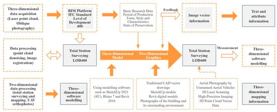
Figure 1.
Workflow for the Database Construction Phase (Through the coupling of three-dimensional and two-dimensional information, the establishment of a digital model is ultimately achieved).
2.3. Information Collection and Processing for the Architecture Pavilion Revit Database
In the digital preservation practice of the Architecture Pavilion at Inner Mongolia University of Technology, a systematic framework integrating multi-source heterogeneous data was established. This research systematically consolidated diverse data sources from varying spatio-temporal scales and technical methodologies—including high-precision oblique photogrammetric reality models (capturing macro-scale morphology and fine-detail textures), 3D laser point clouds (accurately recording geometric structures and surface characteristics), historical and current CAD drawings (providing design intent and modification information), parametric information models (containing component attributes and relationships), historical and contemporary photographic records (revealing historical transformations and traces of use), and relevant archival documents (carrying historical context and cultural significance) []. This has formed a multidimensional information network with spatiotemporal continuity (as illustrated in Figure 2). This network not only overcomes the limitations of singular data sources but, through the interconnection and corroboration of data, enables a comprehensive, dynamic, and multi-layered analysis of the architectural complex’s historical stratification, spatial characteristics, construction techniques, material properties, and the socio-cultural significance it embodies.
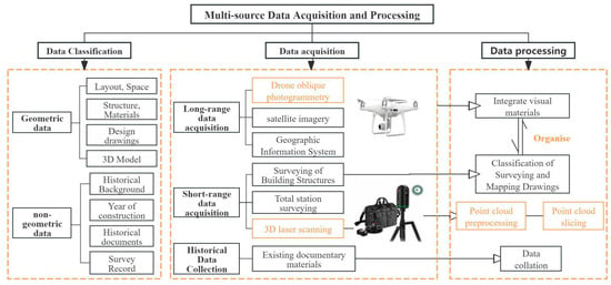
Figure 2.
Multi-source Data Acquisition and Processing for Architectural Structures.
2.3.1. Collection and Processing of Textual and Visual Archival Information
This study systematically collected key unstructured historical materials from different periods concerning the Architecture Building at Inner Mongolia University of Technology, including historical photographs, repair and maintenance logs, and relevant research papers (see Table 1 for details). To effectively process and analyse these heterogeneous data sources, we employed a multimodal data processing approach: firstly, optical character recognition (OCR) technology was utilised to convert paper documents (logs and old papers) into searchable digital text []. Secondly, deep learning-based image recognition algorithms (CNN and ResNet) were applied to conduct in-depth analysis of historical photographs, automatically extracting and quantifying key architectural form characteristics []. Within the collective memory theoretical framework, we further conducted in-depth semantic content analysis of the photograph repository. By identifying and quantifying frequently occurring architectural components/spaces bearing significant era-specific or functional markers, we ultimately identified 12 core memory carriers, including “truss structures” and “steel staircases” (see Figure 3). The multi-source heterogeneous data and their intrinsic relationships, formed through digital processing and structured analysis, established the core data foundation for constructing the BIM database of this industrial building. This provides indispensable data support for its subsequent full lifecycle management, encompassing historical information archiving and tracing, current condition diagnosis and assessment, maintenance strategies, and future adaptive refurbishment [].

Table 1.
Multimodal Processing and Analysis Framework for Historical Materials in the Architecture Pavilion.
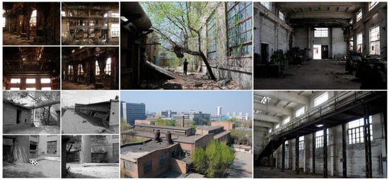
Figure 3.
Photographs of the Architecture Building at Inner Mongolia University of Technology prior to renovation.
This study systematically integrated multiple historical CAD files of the Architecture Pavilion, including the original 1968 design drawings, the 1995 detailed survey plans, and the 2008 renovation construction drawings, establishing a rigorous digital drawing version management system. Through high-precision spatial geometric feature comparisons, it reveals key structural evolution: column grid spacing expanded from the initial 6 m × 6 m to 8 m × 8 m, while the primary load-bearing system underwent a fundamental transformation from brick masonry to reinforced concrete frame construction. During the subsequent Historical Building Information Modelling (HBIM) process, these calibrated CAD drawings served as precise spatial reference basemaps. They provided reliable historical geometric foundations for parametric component modelling, ensuring high-fidelity reproduction of critical historical spatial information and construction details within the digital environment (see Figure 4).
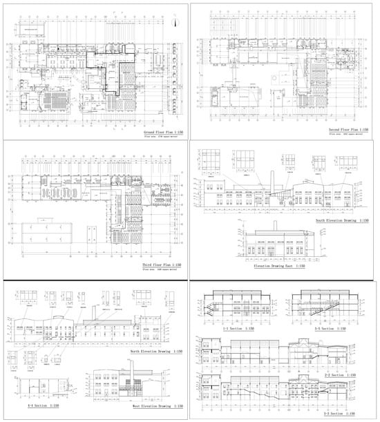
Figure 4.
Architecture Pavilion 2008 Renovation CAD Plans, Elevations, Sections, Structural Details.
2.3.2. Acquisition and Processing of Three-Dimensional Data Information
The acquisition of three-dimensional models is primarily achieved through two distinct methods []. Firstly, models are constructed using three-dimensional modelling software based on data obtained from field surveys and mapping. Secondly, image data is gathered via laser scanners or drone-based oblique photography techniques, subsequently processed through relevant software to generate three-dimensional models. This yields colour point cloud data from data processing and three-dimensional mesh models from drone measurements. Information gathering and data for the Architectural Pavilion drew upon high-resolution imagery, 3D laser scanners, UAV oblique photography, and historical archives, supplementing details concerning structural components, ground-level information, and elevated data. Comprehensive documentation was compiled regarding the building’s form and constituent materials, yielding architectural records in the form of point clouds and photographic records. Scanning surveys and data collection were conducted on the building’s exterior facades and interior spaces, with particular emphasis on documenting ground-level information concerning the internal truss structure alongside external stone and brick wall surfaces [].
Tilted Photogrammetry Data from Drones: Oblique photogrammetry encompasses both fieldwork and office processing. For fieldwork, the author employed a DJI Mavic 2 Pro Professional Edition (SZ DJI Technology Co., Ltd., Shenzhen, China) equipped with a 12.7-megapixel, 28 mm equivalent focal length all-glass wide-angle lens to collect oblique photogrammetric data via drone, thereby acquiring multi-angle imagery of the building structure and its surrounding environment. Given the complex three-dimensional structure of the building complex and its surroundings, the author meticulously designed five flight routes: one orthophoto route, primarily used to capture vertical imagery of the building’s roof and surrounding ground surfaces, ensuring the integrity of roof texture and the accuracy of ground feature plane positioning, and four oblique flight paths: circling the target at a specific angle (approximately 45°), these paths simultaneously captured imagery of the building’s facades and lateral surroundings from the east, south, west, and north directions. The forward overlap rate and sideways overlap rate were set at 80% and 70% respectively (as shown in Figure 5). The flight mission strictly adhered to the predefined routes, yielding 5474 low-altitude photographic images with raw data reaching 43.7 GB (as shown in Figure 6). This fully reflects the coverage density and image quality achieved. Ground control point measurements employed RTK technology (SZ DJI Technology Co., Ltd., Shenzhen, China), utilising geodetic heights obtained from the Inner Mongolia Autonomous Region CORS network. Elevation corrections were applied based on refined geoid data for Hohhot’s Xincheng District. A uniform grid layout was employed, with image control points established at intervals of 75–100 m. A total of 19 survey stations (accuracy: ±5 mm) were established, with scanning data transmitted via dual-band Wi-Fi. The point cloud processing software integrated within the T10 tablet automatically assembled the data into a point cloud model containing three-dimensional information. Upon completion of the scanning and measurement task for the target structure, the data could be transferred for in-house processing [].

Figure 5.
Architecture Pavilion Drone Flight Path Planning Diagram.
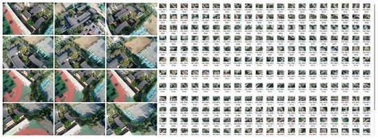
Figure 6.
Aerial Photographs of the Architecture Pavilion (Exhibition Section).
In-house processing is conducted on PC platforms, employing specialised software to perform precise registration of the initial point cloud. The registration process is strictly constrained by ground control points (GCPs), with residual errors for control points maintained within ±0.015 m. This ensures the point cloud model meets absolute positioning accuracy requirements (planar accuracy: ±0.02 m; elevation accuracy: ±0.03 m). Subsequently, the high-precision point cloud and imagery data are imported into ContextCapture software (10.20 version) for photorealistic 3D model reconstruction. During model reconstruction, errors were managed through optimised connection point matching, outlier detection and removal, control of triangulation mesh density, and texture mapping quality []. The final model’s accuracy was validated via check points (CPs), demonstrating a root mean square error (RMSE) of less than ±0.025 m in planimetric accuracy and less than ±0.035 m in elevation accuracy. The final output comprises a static three-dimensional real-world model of the target (as illustrated in Figure 7). Data processing adhered to a rigorous oblique photogrammetry workflow (as depicted in Figure 8). This model incorporates geometric information such as building surface textures and spatial morphology, alongside physical properties including material reflectance.

Figure 7.
Architecture Pavilion CloudCompare-processed dense point cloud map.

Figure 8.
Technical Process for UAV Oblique Photogrammetry 3D Modelling.
3D laser scanning data: High-density point clouds of the building’s interior spaces were captured using Faro Focus S350 (FARO Technologies, Inc., Lake Mary, FL, USA) and Leica BLK360 (Leica Geosystems AG, Heerbrugg, Switzerland) laser scanners. Following registration processing via the CloudCompare open-source platform, Autodesk ReCap Pro pre-processed the data to generate RCP format point cloud containers. Spatial registration was achieved through Revit’s point cloud engine [], producing a three-dimensional point cloud model with an accuracy of ±2 mm. This data captures façade details including the width of mortar joints in exposed brickwork (8–12 mm) and degree of corrosion on steel components (cross-sectional loss rate 5–18%). For complex internal structures within the building complex—such as atriums, corridors, classrooms, and stairwells—key areas must first be prioritised based on spatial function. For instance, atriums require multi-level station placement to ensure vertical data continuity, while corridor corners and stairwells demand increased station density to eliminate blind spots. Secondly, adjacent stations should maintain 30–50% overlap, leveraging BLK360’s VIS visual tracking technology for automatic stitching. Consequently, for Buildings A and B of the Architecture Pavilion at Inner Mongolia University of Technology, the author deployed 138 scanning stations (80 on exterior facades, 58 in complex interior areas), generating approximately 19 billion raw point cloud data points (Figure 9 and Figure 10).
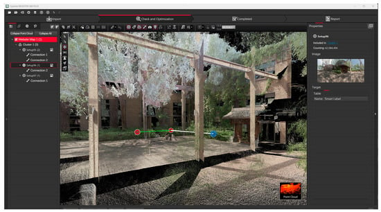
Figure 9.
Exterior of the Architecture Pavilion captured by the Faro Focus S350 scanner.
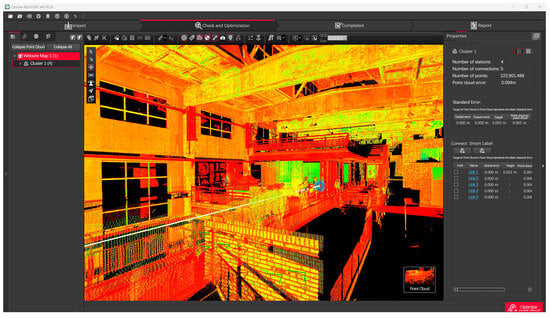
Figure 10.
Leica BLK360 laser scanner data captured within the building’s interior.
2.3.3. Data Acquisition and Processing of Image and Model Information
The experimental digital model of the Architecture Pavilion was constructed through a collaborative workflow utilizing three distinct modeling platforms: Revit 2018, SketchUp 2021, and Rhino 7 (Figure 11 and Figure 12). Revit 2018 served as the core platform for developing the Building Information Model (BIM), establishing the fundamental architectural and structural framework. SketchUp 2021 was employed for the efficient generation of the primary geometric massing. Rhino 7 facilitated the complex task of parametric modeling for the irregular curved surfaces and intricate geometries. To ensure seamless interoperability and data integrity throughout the modeling process, Industry Foundation Classes (IFC) format was rigorously employed for data exchange between the software applications. Following model integration, the visualization phase utilized D5 Render 2.8 and 3ds Max 2022 to simulate the architectural context under realistic lighting conditions, significantly enhancing the visual fidelity of the scene. Final rendering and post-processing were then performed to refine the visualization outputs for presentation and analysis.
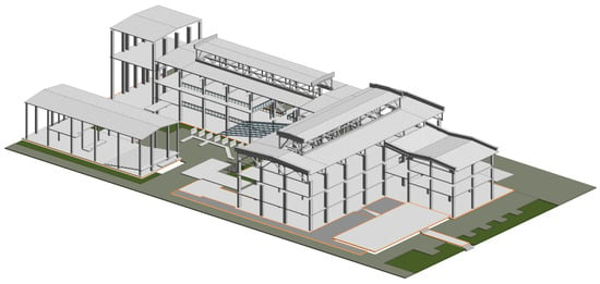
Figure 11.
Architectural Pavilion Revit 3D Model Diagram.
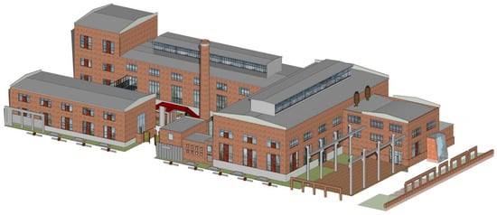
Figure 12.
Architectural Pavilion SketchUp 3D Model Diagram.
2.4. Construction of Architectural Archives Databases Through Multi-Source Data Integration
The digital conservation practices at the Architecture Pavilion reveal that establishing a robust multi-source heterogeneous data integration framework is an indispensable cognitive foundation for systematically interpreting its multidimensional heritage value. Through the precise integration of complementary spatio-temporal data sources—including oblique photogrammetry, 3D laser scanning, traditional CAD 2017 drawings (providing design intent and precise dimensions), historical image archives, and detailed textual records—we have successfully constructed an information network spanning the building’s entire lifecycle, spatial continuity, and temporal evolution. The experimental methodology employed herein achieves deep coupling of multi-source heterogeneous data through a five-stage closed-loop process: Firstly, during the spatio-temporal reference unification phase, the Bursa-Wolf model is applied to force all data into a unified coordinate system. Rigid registration between laser point clouds and oblique photogrammetric models is accomplished via the ICP algorithm, utilising prominent geometric features (building entrance hall corners/classroom roof lines), thereby establishing a millimetre-accurate point cloud real-world model skeleton. Concurrently, precise alignment is achieved by fitting planes to point clouds using CAD model axes as reference. Historical imagery undergoes temporal registration to construct a spatio-temporal integrated base map. Secondly, the BIM model reconstruction and semantic enhancement phase commences: using the registered data as geometric reference, high-precision models are generated via reverse modelling with Scan-to-BIM tools, with oblique photogrammetry textures applied for material assignment; Simultaneously, textual records are linked to components via ROC to construct a BIM spatio-temporal graph with spatial objects and event documents as nodes. Finally, at the spatio-temporal integration and visualisation layer, registered historical imagery is fused with the BIM model as dynamic textures, enabling retrospective site evolution tracking. Component construction dates and service lives facilitate lifecycle monitoring, culminating in the creation of visualised models and digital archives for the architectural archive via the BIM platform [].
Within this framework, we have established a dedicated thematic database for the Architectural Heritage of Inner Mongolia University of Technology. This database transcends a mere repository of information; it employs a logic and classification system grounded in the recognition of architectural heritage value—such as historical periods, component types, material properties, and conservation status—to structurally store and semantically link all aforementioned heterogeneous data. This encompasses textual reports, high-resolution imagery, historical footage, and digitised physical artefacts. This data structure (as illustrated in Table 2) ensures the inherent logical coherence and traceability of information. The database’s key value lies in its robust knowledge organisation and retrieval capabilities: through keyword searches (e.g., specific component names and historical events), categorised browsing (e.g., by era and material type), and potential cross-media associative searches (e.g., locating the corresponding 3D model position or related documentary records from a historical photograph, see Figure 13), enables researchers to efficiently penetrate vast datasets, precisely locate and contextualise critical evidence chains defining architectural heritage value. This significantly enhances the depth, breadth, and efficiency of heritage value recognition, transforming the database into a dynamic repository that underpins research and conservation decision-making.

Table 2.
Approaches to Processing and Representation of Multi-source Data Integration.
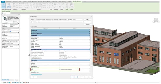
Figure 13.
URL parameter indexing method (URL is a method for identifying the location of a resource, enabling users to access specific web pages or other online resources through a browser).
This study ultimately achieved the construction of a multi-source integrated architectural database for the Building Gallery through three phases: data processing, data publication, and data presentation []. Data processing primarily utilised IFC and COBie formats. Initially, relevant data concerning the architectural gallery was gathered, encompassing geographical location, building specifications, surrounding environment, CAD vector information, and three-dimensional models. Subsequently, data conversion tools were employed to transform disparate formats into Revit-compatible data. The converted data was then imported into the Revit workspace for further processing and analysis. This process involved integrating multi-source data into the Revit platform, as illustrated in Figure 14.
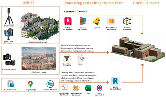
Figure 14.
The various stages of processing and editing input data to generate architectural Revit models.
3. Establishment and Application of BIM Family Libraries in the Architecture Pavilion
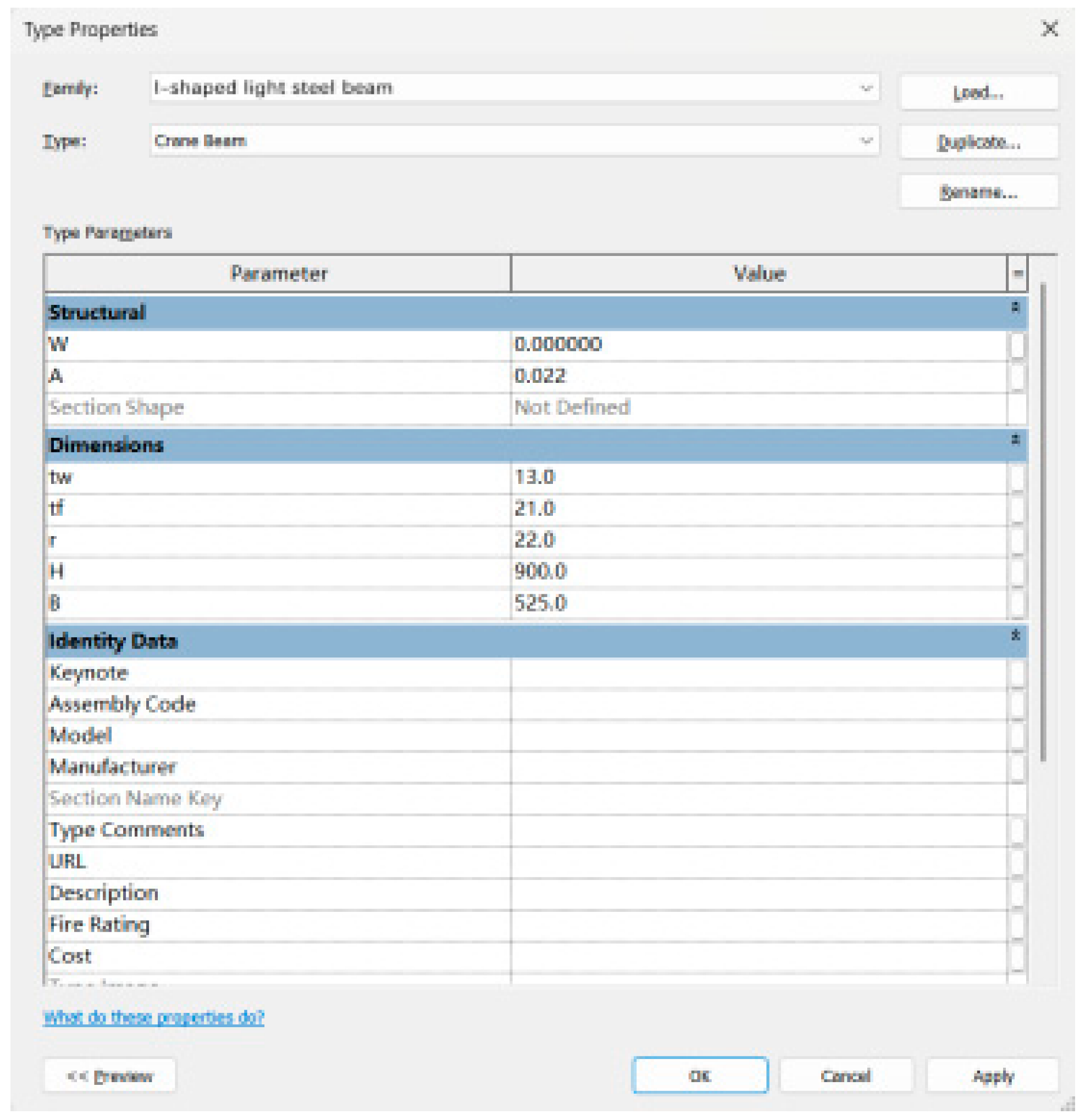
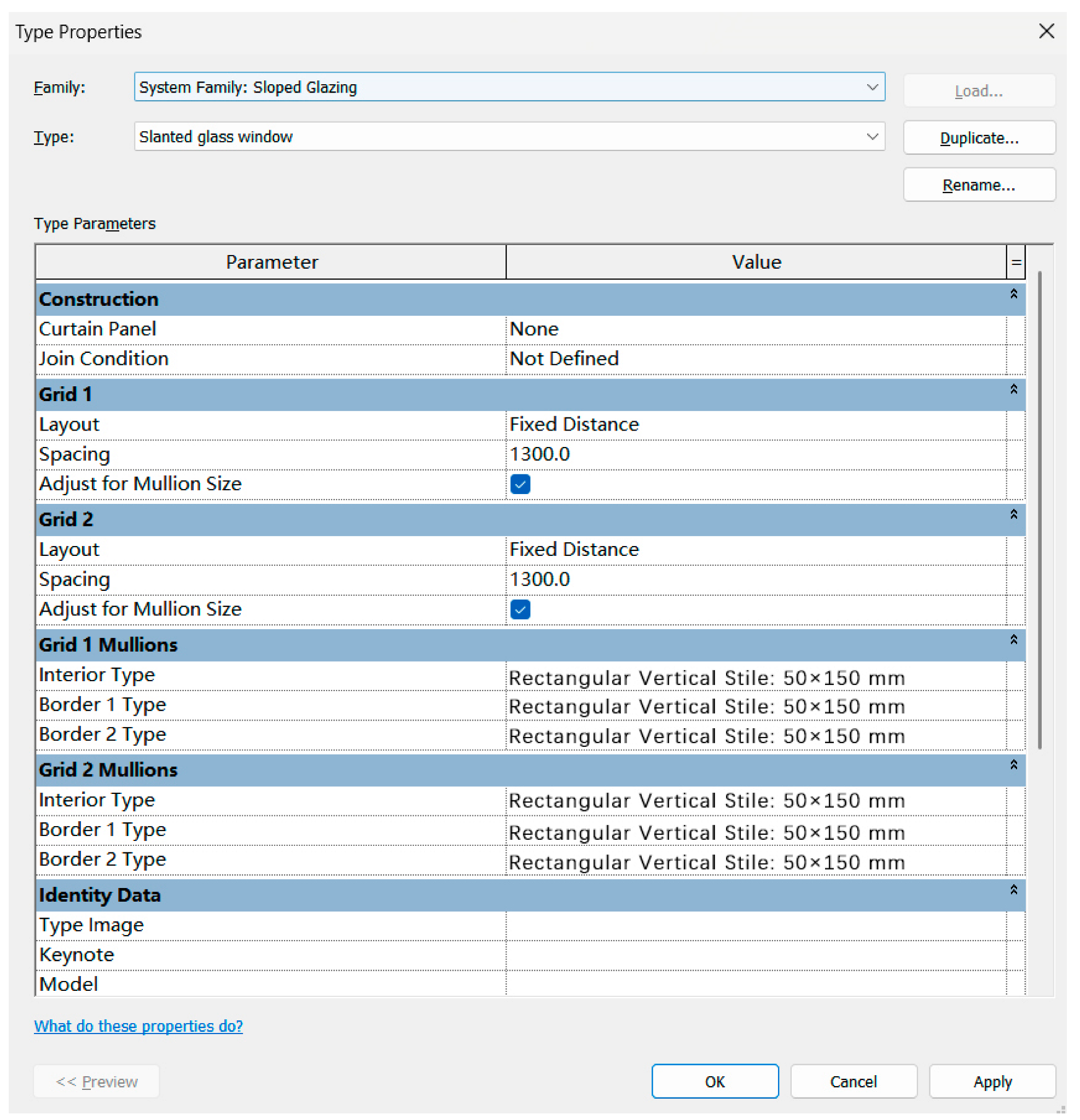
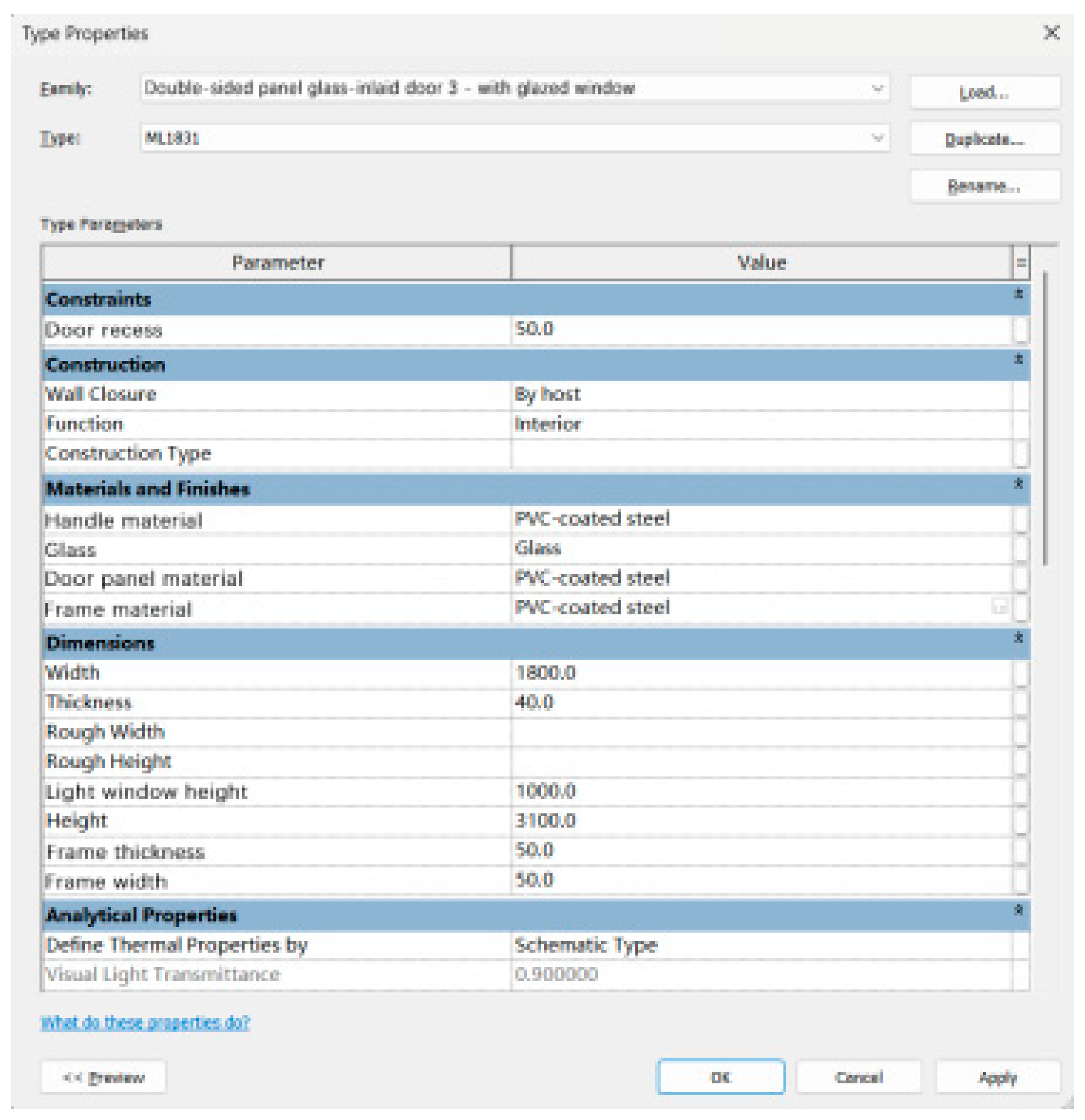
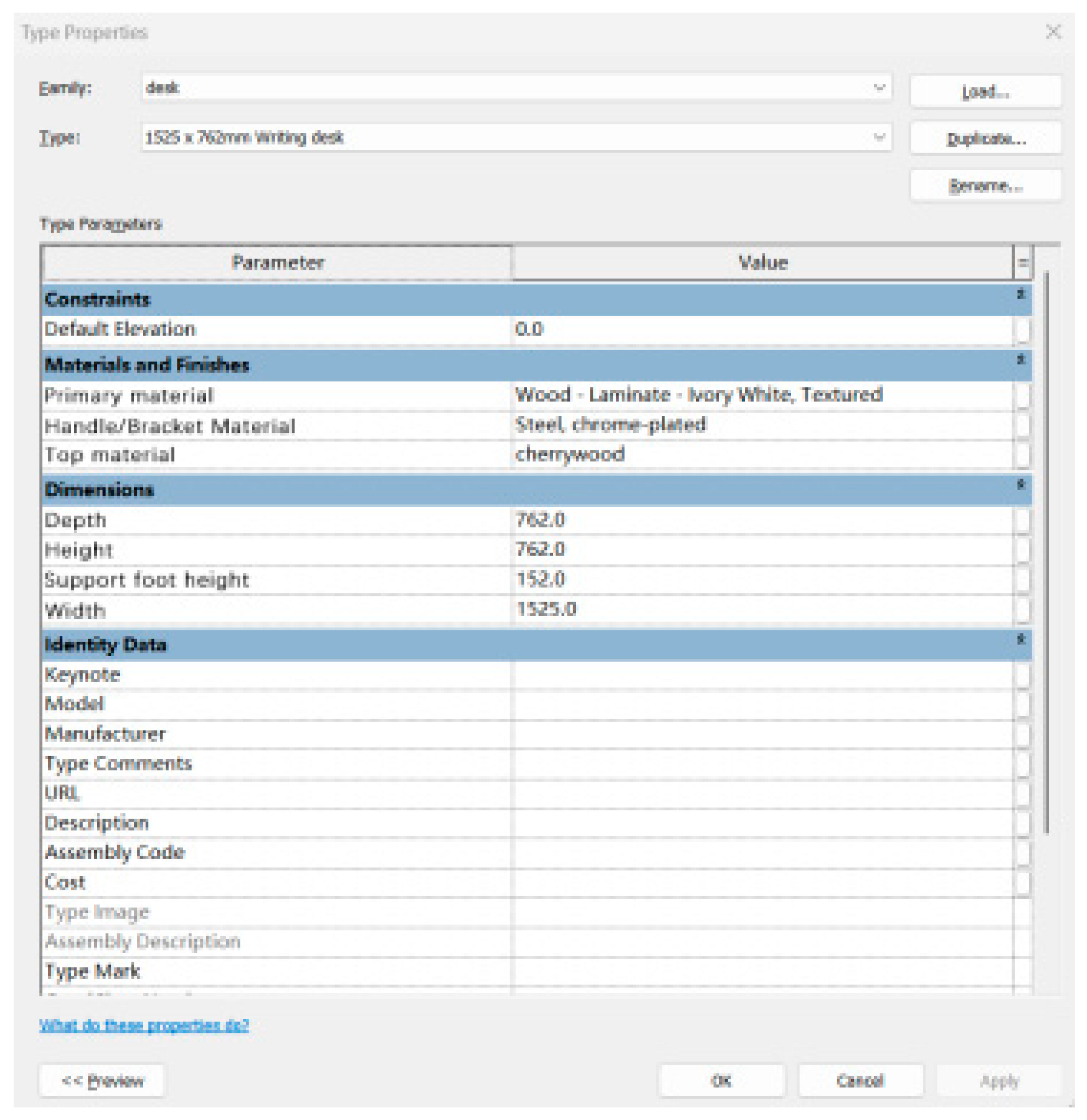
Within the field of digital architectural design, families serve as the core building blocks of the Revit Architecture platform, occupying a pivotal position in the construction of Building Information Models (BIM). From an academic perspective, all model elements and annotation elements within the Revit Architecture 2018 software system are fundamentally composed of various types of component families, collectively forming a comprehensive Building Information Modelling framework. Analysis of Revit reveals that families are primarily categorised into two fundamental types: system families and loadable families []. System families are predefined during software initialisation, with their information stored within template and project files. Their core function lies in generating fundamental elements constituting the foundational framework of architectural projects. These system families provide standardised, foundational building blocks for architectural projects, ensuring the standardisation and consistency of model construction. In contrast, loadable families offer high flexibility and customisation capabilities. Designers may define and create families independently to meet specific project requirements, or obtain customised family components through interdisciplinary collaboration (Table 3). To ensure versatility and accessibility, loadable families are stored independently as family files in the ‘.rfa’ format. This facilitates their reuse, sharing, and management across different projects, significantly enhancing the efficiency and adaptability of Building Information Modelling (BIM) construction.

Table 3.
Building Component Family Properties Table.
In the field of digital design and information management for architecture, the configuration of families plays a pivotal role in the structuring of information. By inputting family attributes, stored information and value-based data can be transformed into structured formats, thereby enhancing the efficiency and accuracy of information management. This process extends not only through the construction phase of the ideal model but also encompasses the addition of external attribute information to the model. In the context of industrial heritage information collection and management, the application of BIM technology has demonstrated significant potential for information structuring. BIM technology addresses the ‘information silo’ issue prevalent in architectural heritage management. Its application extends beyond architectural heritage to encompass industrial heritage information management. Through BIM, the collection, modelling, and management of information concerning industrial heritage structures, equipment, production processes, and industrial environments can be achieved. At the system performance level, pre-fabricated and parametric family libraries significantly reduce the modelling time costs and computational resource consumption associated with complex industrial components. By invoking predefined family templates (as per Table 4), designers can efficiently reuse standard components, avoiding repetitive geometric modelling operations. This substantially enhances system responsiveness and model processing efficiency. For industrial heritage components exhibiting high repetition or strong regularity, the application of family libraries significantly optimises memory usage and model lightweighting. This provides performance assurance for overall BIM model construction and real-time interaction.

Table 4.
Standardised Design of Component Family Attribute Tables for the Architecture Pavilion.
The configuration of family attributes can be achieved by converting stored information and value data into family attributes through customised properties, thereby enabling information structuring. The core of this process lies in ensuring precise correspondence between family attribute definitions and physical objects—that is, data alignment accuracy. This study safeguards precision through the following mechanisms: Firstly, critical geometric dimensions (such as the cross-sectional dimensions of corbel columns, corbel cantilever lengths, truss member lengths, and node positions) are calibrated and set strictly based on point cloud data obtained from detailed on-site surveying or measured drawings. Family parameters (as shown in Table 5) serve as the precise bridge connecting physical geometry and the digital model. Secondly, attribute information must originate from reliable sources. Material properties, construction practices (e.g., corbel reinforcement configuration, truss node connection methods) and other details are rigorously entered into family attribute sets based on historical archives or inspection reports, ensuring non-geometric information aligns with physical conditions or historical authenticity. Finally, differentiated modelling precision (Level of Detail, LOD) standards are implemented according to a component’s significance in heritage value interpretation and structural analysis. The corbel columns in the Architecture Pavilion, being key heritage feature components, employ high-precision modelling (LOD 400) to accurately reflect their construction details. Conversely, secondary or repetitive components may utilise relatively lower precision (LOD 300/350) to balance efficiency and accuracy requirements.

Table 5.
Building Component Attribute Record Form.
By utilising the pre-fabricated family file ‘Pre-fabricated—Rectangular Column with Corbel—BZO34-037′ for instantiation, system performance improvements over modelling from scratch are demonstrated as follows: experiments show modelling time reduced by approximately 70%, with the model file size increment significantly lower than an equivalent manually created model. Furthermore, near real-time responsiveness is achieved during subsequent parameter adjustments. By customising and editing families, operators can define dimensions and forms to generate more complex and diverse corbels. Taking the Architecture Pavilion as an example, corbel modelling is realised via custom structural column families. Within industrial heritage buildings, trusses function similarly to corbel columns. In Revit, truss family templates are provided. Trusses comprise multiple members and connectors, forming complex structures. The truss family template is established to facilitate simplified representation and load behaviour within the BIM model, conveying truss composition and load conditions in the most concise manner, as illustrated in Figure 15. The results indicate that although customised family editing requires initial investment, the complex variants it generates—such as corbels and intricate truss forms—can similarly achieve the aforementioned performance advantages once incorporated into the family library. This ensures efficient model maintenance and information updates throughout the project lifecycle.
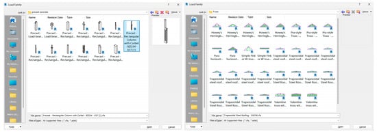
Figure 15.
Loadable families for corbels and trusses in the Architecture Library.
To ensure the established BIM family library accurately reflects the geometric characteristics of the industrial heritage artefact, this study employs two systematic comparison and validation methods (using corbels as an example): The first method involves 3D laser scan point cloud comparison: high-precision 3D laser scanning is conducted on the corbels to obtain millimetre-level accuracy point cloud data. The constructed BIM family instance is precisely aligned (via common reference points or best-fit algorithms) to the corresponding point cloud coordinate system. Utilising deviation analysis functions in CloudCompare, Autodesk ReCap + Revit, spatial distance deviations between the BIM model surface and point cloud data were calculated, generating colour-coded deviation maps. Statistical analysis yielded an average deviation of +0.7, standard deviation of 2.1, maximum deviation of +8.2, and minimum deviation of −5.3. Following quantitative assessment of model geometric accuracy, family parameters were iteratively optimised accordingly. The second method involves photogrammetry-assisted verification: high-resolution close-range photogrammetry captures multi-angle imagery of components. Within BIM, the corbel column view is overlaid with the corresponding corrected imagery for visual comparison. This examines the alignment of contour lines and corbel edge lines, identifying significant deviations discernible to the naked eye.
Among Inner Mongolia’s industrial architectural heritage, the column systems of factory buildings exhibit pronounced structural morphological differentiation. The most distinctive structural feature and heritage asset lies in the application of multi-specification corbel columns. These corbels are not superimposed decorative elements but integral load-bearing and force-transferring components within the original factory structure. Their distinctive cantilevered forms, dimensional variations, and construction details directly reflect the specific spatial and load requirements of particular production processes. They serve as crucial material evidence for deciphering the coupling relationships between industrial construction techniques, material applications, and functional spaces during this period. In-depth research into corbels holds foundational significance for establishing a typological framework for industrial architectural heritage and for accurately interpreting its historical, technical, and cultural value. It also provides core structural evidence for subsequent refined information modelling and value interpretation within the digital archive repository.
4. Application of the Architecture Pavilion Database Platform
4.1. Information Retrieval and Management Applications
In the realm of information retrieval and application, taking the Architecture Library of Inner Mongolia University of Technology as a case study, a multi-faceted database framework for industrial architectural heritage was established on the Revit platform. Through the integration of technical tool chains and cross-stage process design, this framework achieved the systematic integration of historical information, geometric data, and real-time monitoring data []. The research first employed Autodesk Revit and ReCap Pro to calibrate building point cloud data and perform parametric modelling, establishing a comprehensive data system encompassing ‘original industrial components—subsequent modifications—environmental monitoring data’ [] (Figure 16).
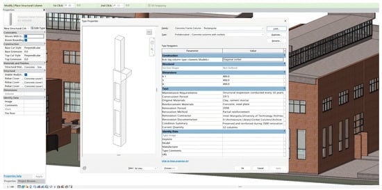
Figure 16.
Schematic Diagram of BIM Information Recording for the Architecture Pavilion (Taking the Corbel as an Example).
During the modelling phase, layered modelling techniques distinguished historical structures from modern interventions. Professional attributes such as material chronology and conservation grades were assigned, establishing a cross-database linkage mechanism based on unique component identifiers to resolve heterogeneous data integration challenges. This culminated in an integrated industrial heritage digital management system combining ‘digital twin modelling—historical archive association—real-time monitoring and early warning’. This research not only established a dynamic, full-lifecycle database for the Architecture Pavilion but also pioneered replicable technical pathways for the digital preservation of industrial architectural heritage through innovative approaches such as ISO 19650 [] standard data classification and the development of a dedicated Revit family library. It effectively fosters interdisciplinary collaboration between architecture, heritage conservation, and information technology, demonstrating significant academic value and practical significance in perpetually preserving historical value, scientifically informing conservation decisions, and facilitating public participatory dissemination [].
4.2. Information and Applications of Architectural 3D Models
Following the completion of data processing and integration, the architectural model of the gallery was constructed using Revit software 2018 []. Initially, the fundamental framework and structure of the gallery were established within Revit based on the acquired digital information []. Subsequently, architectural details and decorative elements such as doors, windows, staircases, and balustrades were progressively incorporated. Throughout the modelling process, meticulous attention was paid to ensuring the model’s accuracy and completeness. Historical documents, archival records, and photographic imagery were consulted to ensure the architectural model’s appearance and structure matched the actual building. Concurrently, parametric design principles were applied to facilitate subsequent modifications and adjustments, as illustrated in Figure 17, Figure 18, Figure 19 and Figure 20.

Figure 17.
Facade of the Architectural Pavilion Delivered via BIM Model (South facade, 1:150).

Figure 18.
Floor Plans for the First and Second Floors of the Architecture Pavilion Delivered via BIM Model.
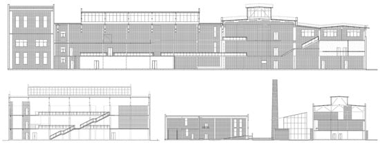
Figure 19.
Section view of the architectural pavilion delivered via BIM model.
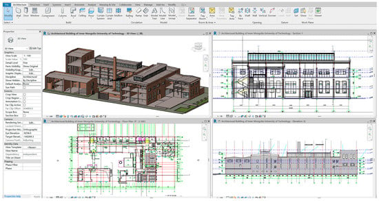
Figure 20.
Multiple Views of the Architectural Pavilion Revit Model.
Upon completion of the model construction, the digitised information gathered for the building must be entered into the Revit model for information management. The historical background, developmental journey, structural characteristics, and material information of the building should be incorporated into the model to facilitate subsequent queries and analysis, utilising Revit’s parametric design capabilities to categorise and manage the information within the building model. Structural details, material specifications, and equipment information should be assigned to distinct parameters for streamlined subsequent querying and analysis [].
Upon model generation, the architectural gallery model undergoes validation to ensure accuracy and completeness. This involves comparing the model against physical conditions and conducting structural analyses. Any identified issues require prompt modification and adjustment. Revit’s parametric design capabilities facilitate rapid alterations to the architectural gallery model.
Following model validation, optimise the architectural model to enhance its quality and performance. This involves refining geometric shapes, reducing polygon counts, and improving rendering quality and employing software such as Autodesk 3ds Max 2022 or Maya 2024 for advanced geometric processing and rendering to elevate model quality and performance (Figure 21).
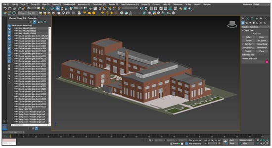
Figure 21.
Autodesk 3ds Max rendered visualisation.
Upon completing model optimisation, the architectural model is exported into various formats such as DWG, PDF, and IFC to facilitate interoperability and application with other software. Concurrently, the model may be exported as images or videos for presentation and promotional purposes (Figure 22).
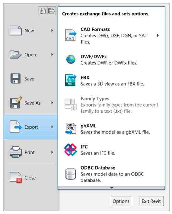
Figure 22.
Revit Output Formats.
4.3. Architecture Pavilion 3D Visualisation Interactive Application
The complexity of the Architecture Pavilion at Inner Mongolia University of Technology—featuring both original industrial elements such as brick-clad exterior walls and steel roof trusses, alongside later additions—has resulted in data acquisition challenges including geometric deviations (e.g., ±3 mm accuracy discrepancy between laser point clouds and Revit models) and format incompatibilities. By integrating tools such as Forge, Unity, and Enscape VR through a Revit plugin, a unified technical framework has been established: “Model Unification —lightweighting—data layered integration—multi-platform adaptive adaptation” []. This ensures seamless integration across initial construction, renovation, and current-state models, resolving traditional multi-platform data silos []. It provides a universal framework for cross-media dissemination of industrial heritage (from academic research to public outreach) [], ultimately achieving the objectives of “standardised conservation techniques, diversified presentation formats, and multifaceted application scenarios,” [] as illustrated in Figure 23.
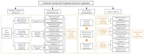
Figure 23.
Architectural Pavilion 3D Visualisation Interactive Application Process.
Industrial architectural heritage stands as a testament to Inner Mongolia’s industrial development journey, bearing rich historical information and cultural significance. Through visualisation techniques such as three-dimensional modelling and virtual exhibitions, the original appearance, construction processes, and production scenes of these heritage sites can be vividly presented, enabling people to gain a more intuitive understanding of the historical trajectory of Inner Mongolia’s industrial advancement. Employing 3D modelling and virtual reality technologies can reconstruct the former production processes within foundry workshops, transporting visitors through time to experience the atmosphere of bygone industrial eras. To highlight distinctive features of industrial architectural heritage, dedicated ‘Industrial Components’ query classifications and layers have been established. Users can swiftly locate industrial elements such as large-span structures, skylights, corbels, crane beam remnants, and specialised equipment foundations, while accessing detailed information. Historical evolution layers and colour coding clearly illustrate the transformation from industrial plant to educational building, such as added floors, partition walls, modified door/window openings, and extensions []. Comparing models from different periods visually demonstrates the renovation process. For educational adaptation, linking to teaching case libraries enables rapid access to classic structural node model display areas. Simultaneously, meticulously designed interactive tours and information points guide users to comprehend the building’s historical, technological, socio-cultural, and artistic value. For instance, information points highlight innovative construction techniques to demonstrate technological merit, while narrating historical narratives behind the structure elucidates its socio-cultural significance.
5. Building Lifecycle Information Management
The lifecycle information management of industrial architectural heritage refers to the comprehensive process of planning, monitoring, maintaining, and managing buildings throughout their entire lifecycle—from design and construction through to use and eventual decommissioning []. This concept emphasises the sustainable conservation of architectural heritage, ensuring structures remain in good condition throughout their lifecycle, extending their service life, and guaranteeing appropriate treatment and protection upon decommissioning []. Key management priorities should encompass current condition information for each life stage, maintenance records, structural safety data, and subsequent exploration of renewal and conservation approaches for architectural heritage (Figure 24). It should be specifically noted that the HBIM model currently developed in this study primarily realises the ‘building digital twin’, whilst the ‘structural digital twin’ incorporating mechanical parameters, load characteristics and foundation information remains under development. Future work will integrate finite element analysis (FEM) models to achieve static and seismic safety verification, with this task designated as a core research direction for subsequent phases.
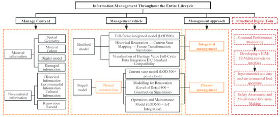
Figure 24.
Full Lifecycle Information Management Module.
5.1. Integrated Management of Architectural Gallery Information
The integrated management of industrial architectural heritage essentially involves establishing a digital governance system spanning the entire lifecycle. Its core lies in achieving dynamic mapping between physical and information spaces through the fusion and intelligent processing of multi-source, heterogeneous data. Firstly, a parametric BIM model is constructed using the Revit platform. Component-level attribute coding is achieved through the IFC 4.0 standard, serving as the primary information carrier. The model itself integrates attribute information such as component dimensions and materials, whilst also encompassing non-material information including the building’s construction logic []. Link the pre-processed three-dimensional laser point cloud data to Revit in RCP format to facilitate accuracy verification of the building mode l []. Secondly, existing condition information from the preliminary phase is linked as images to corresponding building components. Following integrated and phased data entry within Revit, component-specific information can be directly viewed within the model. Shared parameters for each component can also be exported by phase via schedules, enabling more organised information output and facilitating categorised archiving (Figure 25, Figure 26 and Figure 27). Finally, employ the RDF (Resource Description Framework) triplet model for ontology modelling of entities such as building components, historical events, and material properties. Utilise the Neo4j graph database to perform cross-domain knowledge association reasoning. However, to meet the requirements for structural safety assessment and adaptive reuse of industrial heritage, future work must integrate structural engineering data—including material mechanical properties, load characteristics, and foundation information—to establish deep connections with finite element analysis (FEA) models. This will form the core task of the next phase of this research, advancing from Building Information Modelling (BIM) towards an integrated ‘structural–functional digital twin’.
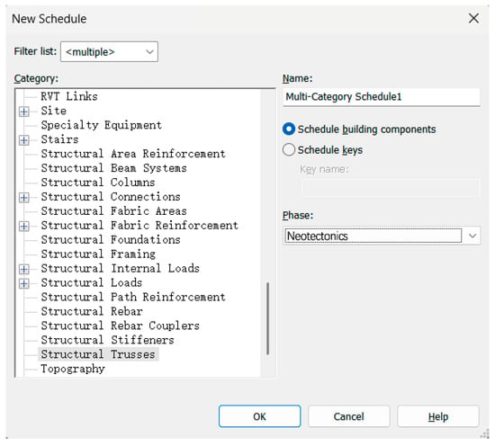
Figure 25.
Detailed Schedule for the Architecture Pavilion: Phase Setup.
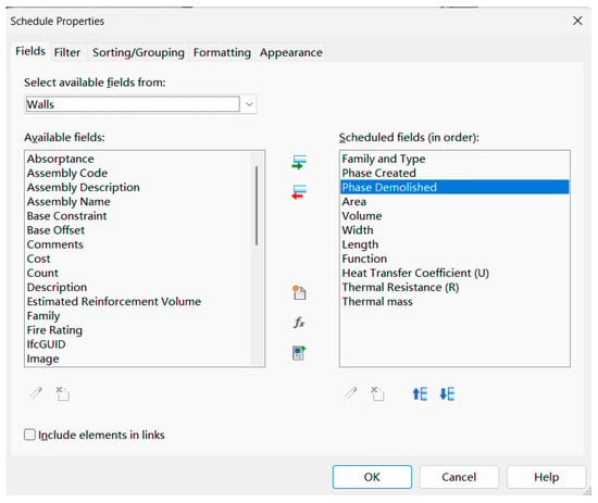
Figure 26.
Detail Sheet Properties Settings.
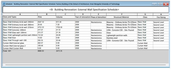
Figure 27.
Building Components Specification Schedule.
5.2. Phased Management of Architectural Pavilion Information
The phased model divides model information at specific historical time points based on the previously established ideal model, enabling the information model to depict the building’s appearance across different time periods. BIM can visually represent the construction process in phases, serving as a supplement to photographic and textual documentation. The phased expression of the ideal model serves to store extensive industrial heritage information []. To facilitate integrated management and orderly output, architectural heritage may be divided into distinct life stages. By combining idealised models, as-built models, and visual analysis results, corresponding digital models for each phase can be established. This enables the phased management and presentation of information outcomes across each stage of the heritage asset’s life cycle, constituting phased information management. Such management typically involves recording and managing changes to the building’s physical information [].
The Architectural Gallery at Inner Mongolia University of Technology has undergone new construction and renovations across distinct periods since its inception as a foundry workshop. Drawing upon relevant historical records, several developmental phases have been delineated. Through phased information modelling, updates and modifications across different lifecycle stages are documented, enabling the valuation of this industrial heritage (Figure 28). This study divides the entire information model of the Architecture Gallery into five periods (Table 6), constructing the model holistically while presenting it in phases. The earliest phase was the Inner Mongolia University of Technology Machinery Factory, which served as the university’s teaching practice base. Its foundry workshop was constructed in 1968 and commenced operations in 1971. Following functional requirements and industrial restructuring, various workshop departments gradually fell into disuse, with the entire facility becoming derelict by 1995. In early 2008, the university resolved to renovate the site, breathing new life into it. In 2020, driven by teaching requirements, an extension to the Architecture Gallery (Gallery C) was added and commenced operation in 2021. BIM technology introduces a temporal dimension to industrial heritage conservation, facilitating the reflection of human and natural influences through changes in the building itself and its surrounding environment.
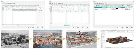
Figure 28.
Phased Implementation of BIM for the Architecture Pavilion at Inner Mongolia University of Technology.

Table 6.
Historical Periodisation of the Architecture Gallery at Inner Mongolia University of Technology.
Firstly, it facilitates a comprehensive understanding of the building’s historical evolution. The Architecture Gallery at Inner Mongolia University of Technology was converted from a disused foundry workshop and has undergone multiple developmental phases. By constructing a phased model, one can clearly trace the building’s transformation from its origins as an abandoned factory to its current status as a multifunctional gallery with distinctive features. Throughout these phases, the building’s functions have been progressively adapted. The phased model can meticulously document the renovation strategies and design philosophies employed during each period. At each juncture, distinct approaches to functional reconfiguration, spatial interpretation, and environmental symbiosis were employed. Secondly, it furnishes a basis for architectural conservation and heritage transmission. Establishing a phased model comprehensively documents the structure’s condition across its lifecycle, providing precise informational foundations for safeguarding and perpetuating this heritage. By examining the model, one gains insight into the building’s structural characteristics and material usage during different periods, enabling more scientifically sound and rational conservation measures. The phased model facilitates the reflection of collective memory, thereby achieving holistic preservation [].
6. Discussion
However, this study also has certain limitations. Firstly, we shall continue to develop the depth and universality of BIM technology applications, requiring further enhancement of modelling precision and efficiency. Although the technical pathway and standard family library established in this study are primarily based on the structural characteristics of a specific case (the Architecture Building at Inner Mongolia University of Technology), its research methodology, analytical framework, and practical experience also hold reference value for adaptive reuse projects involving industrial heritage or renovated historic buildings of similar types within the same geographical region. This is primarily reflected in the shared understanding of regional materials, craftsmanship, cultural context, and renovation requirements. However, the applicability of this study’s conclusions to historical buildings or architectural heritage with different cultural backgrounds, geographical locations, or heritage types requires validation through broader empirical research. For varying foundation conditions, groundwater levels, and seismic zone distributions that directly impact structural safety assessments and reinforcement schemes, structural analysis parameters within the BIM model must be reconfigured for each new site. Structural systems exhibit significant diversity, ranging from timber frameworks, masonry arches, and earthen constructions to early reinforced concrete examples. Research pathways developed for specific structures (e.g., brick–concrete) require fundamental adjustments and redevelopment of structural analysis models and reinforcement methods when applied to timber-framed heritage buildings (requiring attention to mortise-and-tenon joints, bracket sets, and lateral bracing), earthen structures (requiring consideration of rammed earth/adobe properties, damp-proofing, and pest control), and large-scale archaeological sites (requiring assessment of stability in a state of decay). Secondly, the information models and databases currently established primarily focus on static or phased information. How to efficiently and cost-effectively integrate dynamic data generated during subsequent building use, renovation, and maintenance, while ensuring the long-term updating and maintenance of information models, represents a key direction for our future endeavours. Despite these limitations, the theoretical framework and technical pathways developed in this study provide an empirical foundation and innovative approaches for the digital preservation and sustainable reuse of industrial heritage buildings. Future research will continue to explore overcoming technical bottlenecks, deepening dynamic integration, promoting cross-disciplinary collaboration, and expanding application value. This will advance the standardisation, intelligentisation, and widespread adoption of information integration for industrial heritage.
7. Conclusions
This study, using the Architecture Building at Inner Mongolia University of Technology as its empirical subject, systematically constructs a theoretical framework and technical pathway for the integration and application of industrial architectural heritage information under the guidance of sustainability principles. The principal conclusions are as follows:
- The fusion mechanism for multi-source heterogeneous data forms the foundation: Integrating multi-source heterogeneous data acquisition technologies such as textual imagery, three-dimensional laser scanning, and UAV oblique photography, this study proposes a heterogeneous data fusion mechanism and precise reverse modelling methodology tailored to the characteristics of industrial heritage. This not only establishes a BIM database covering the entire lifecycle but, more crucially, resolves the challenge of achieving precise and efficient three-dimensional digitisation for irregular components, complex spaces, and concealed areas within industrial heritage sites. It thereby lays a foundation of accurate data for subsequent analysis.
- Standardised Parametric Family Library for the Sustainable Renewal of Industrial Architectural Heritage: This research did not merely employ generic BIM family libraries, but systematically developed a bespoke parametric BIM component library system. This library demonstrates the structural logic and replaceability design principles of industrial heritage, providing standardised, reusable digital component units for renovation design and maintenance replacement, thereby significantly enhancing refurbishment efficiency.
- Information Modelling Enables Lifecycle Management: The constructed 3D information model not only facilitates spatial visualisation but also integrates structural performance, energy consumption data, and historical value assessments. This supports phased management from diagnostic evaluation to renovation decision-making, enabling precise conservation and reuse strategies.
- Proposing a closed-loop framework for sustainable industrial heritage practices: The core innovation of this study’s four-stage framework—‘collection, processing, integration, and application’—lies in establishing a dynamically updated, value-oriented comprehensive database. This architecture not only bridges the physical and digital realms but also enhances the structured storage and heritage application of cultural value information.
Author Contributions
Conceptualization, L.H., D.C. and M.G.; Data collection, D.C.; Data analysis, D.C.; Funding acquisition, D.C.; Investigation, L.H.; Methodology, D.C.; Project administration, M.G.; Resources, L.H.; Software, D.C.; Supervision, L.H.; Validation, D.C., M.G., M.W. and Y.W.; Visualisation model, D.C.; Writing—original draft, D.C.; Writing—review and editing, L.H. and M.G. All authors have read and agreed to the published version of the manuscript.
Funding
This work was supported by the 2025 Autonomous Region Science and Technology Programme—Research and Development of a Digital Spatial Restoration and Metaverse Multi-modal Interaction Application Platform for Inner Mongolia’s Historical Architectural Heritage (2025YFHH0082); The 2024 First-Class Discipline Research Special Project (YLXKZX-NGD-067) and Grassland Human Settlements Construction System and Key Technologies (YLXKZX-NGD-004).
Institutional Review Board Statement
Not applicable.
Informed Consent Statement
Not applicable.
Data Availability Statement
The original contributions presented in this study are included in the article. Further inquiries can be directed to the corresponding author.
Acknowledgments
The author extends gratitude to Chaoming Li of the School of Architecture at Inner Mongolia University of Technology for his assistance in data collection for certain scenarios.
Conflicts of Interest
The authors declare no conflicts of interest.
References
- Anaç, M.; Arun, G. HBIM supported archive model. J. Fac. Eng. Archit. Gazi Univ. 2024, 39, 443–459. [Google Scholar] [CrossRef]
- Rebec, K.M.; Deanovič, B.; Oostwegel, L. Old buildings need new ideas: Holistic integration of conservation-restoration process data using Heritage Building Information Modelling. J. Cult. Herit. 2022, 55, 30–42. [Google Scholar] [CrossRef]
- Zhong, D.; Huang, P.; Xiong, G.; Li, H. Renewal strategies of industrial heritage based on placeness theory: The case of Guangzhou, China. Cities 2024, 155, 105407. [Google Scholar] [CrossRef]
- Cursi, S.; Martinelli, L.; Paraciani, N.; Calcerano, F.; Gigliarelli, E. Linking external knowledge to heritage BIM. Autom. Constr. 2022, 141, 104444. [Google Scholar] [CrossRef]
- Ávila, F.; Blanca-Hoyos, Á.; Puertas, E.; Gallego, R. HBIM: Background, Current Trends, and Future Prospects. Appl. Sci. 2024, 14, 11191. [Google Scholar] [CrossRef]
- Wain, A.; Rode, A.; Wilkinson, S.; Banishemi, S.; Hirajasouli, A.; Rapp, L. Hearts and Homes: The Potential of Conservation Laser Cleaning for Post-disaster Wellbeing and Waste Reduction. Stud. Conserv. 2022, 67, 309–318. [Google Scholar] [CrossRef]
- Khan, M.; Khan, M.; Bughio, M.; Talpur, B.; Kim, I.; Seo, J. An Integrated HBIM Framework for the Management of Heritage Buildings. Buildings 2022, 12, 964. [Google Scholar] [CrossRef]
- Bastem, S.S.; Cekmis, A. Development of historic building information modelling: A systematic literature review. Build. Res. Inf. 2022, 50, 527–558. [Google Scholar] [CrossRef]
- Guo, M.; Shang, X.; Zhao, J.; Shi, Y.; Sun, M.; Huang, M.; Wang, G.; Liao, L. Digital twin models for architectural heritage conservation. J. Build. Eng. 2025, 112, 113792. [Google Scholar] [CrossRef]
- Penjor, T.; Banihashemi, S.; Hajirasouli, A.; Golzad, H. Heritage building information modeling (HBIM) for heritage conservation: Framework of challenges, gaps, and existing limitations of HBIM. Digit. Appl. Archaeol. Cult. Herit. 2024, 35, e00366. [Google Scholar] [CrossRef]
- Alshawabkeh, Y.; Baik, A.; Miky, Y. HBIM for Conservation of Built Heritage. ISPRS Int. J. Geo-Inf. 2024, 13, 231. [Google Scholar] [CrossRef]
- Esmaeili, H.; Woods, P.C.; Thwaites, H. Virtual Preservation of Contemporary Architectural Heritage in Developing Countries in Absence of Protection Digital Reconstrction, Recording, and Archiving before Complete Disappearance. In Proceedings of the 2015 11th International Conference on Signal-Image Technology & Internet-Based Systems (SITIS), University of Bourgogne, the University of Milan, Bangkok, Thailand, 23–27 November 2015; pp. 796–803. [Google Scholar]
- Xu, C.; Wu, C.; Tan, L.; Wan, D.; Liu, H.; Chen, Z. The Application and Development of Historical Building Information Modeling in Chinese Architectural Heritage: Sustainability Assessment and Prospects. Sustainability 2025, 17, 4667. [Google Scholar] [CrossRef]
- Lombardi, M.; Rizzi, D. Semantic modelling and HBIM: A new multidisciplinary workflow for archaeological heritage. Digit. Appl. Archaeol. Cult. Herit. 2024, 32, e00322. [Google Scholar] [CrossRef]
- De Gregorio, S.; De Vita, M.; De Berardinis, P.; Palmero, L.; Risdonne, A. Designing the Sustainable Adaptive Reuse of Industrial Heritage to Enhance the Local Context. Sustainability 2020, 12, 9059. [Google Scholar] [CrossRef]
- Parrinello, S.; Sanseverino, A.; Fu, H. HBIM Modelling for the Architectural Valorisation via a Maintenance Digital Eco-System. In Proceedings of the 29th CIPA Symposium on Documenting, Understanding, Preserving Cultural Heritage—Humanities and Digital Technologies for Shaping the Future, Florence, Italy, 25–30 June 2023; pp. 1157–1164. [Google Scholar]
- Bottero, M.; D’Alpaos, C.; Oppio, A. Ranking of Adaptive Reuse Strategies for Abandoned Industrial Heritage in Vulnerable Contexts: A Multiple Criteria Decision Aiding Approach. Sustainability 2019, 11, 785. [Google Scholar] [CrossRef]
- Oliveira Magalhães, B.K.; Duarte, G.S.; Brasil de Matos Galvão, A.; Serpa Braga Vasconcelos, A.C.; Barbosa Costa, L.C. Documentation strategies for HBIM model parameterization: A case study of the José de Alencar Theater. Digit. Appl. Archaeol. Cult. Herit. 2025, 38, e00443. [Google Scholar] [CrossRef]
- Salah, R.; Károlyfi, K.A.; Szép, J.; Géczy, N. A structured framework for HBIM standardization: Integrating scan-to-BIM methodologies and heritage conservation standards. Digit. Appl. Archaeol. Cult. Herit. 2025, 37, e00420. [Google Scholar] [CrossRef]
- Chen, L.; Wen, Y.; Zhao, X.; Zhao, X. Digital Archiving of Abandoned Boiler Rooms in the Context of Urban Renewal: A Case Study of Changqing Community, Shenyang, China. Sustainability 2025, 17, 2541. [Google Scholar] [CrossRef]
- Klapa, P.; Żygadło, A.; Pepe, M. 3D Heritage Reconstruction Through HBIM and Multi-Source Data Fusion: Geometric Change Analysis Across Decades. Appl. Sci. 2025, 15, 8929. [Google Scholar] [CrossRef]
- Davila, K.; Setlur, S.; Doermann, D.; Kota, B.U.; Govindaraju, V. Chart Mining: A Survey of Methods for Automated Chart Analysis. IEEE Trans. Pattern Anal. Mach. Intell. 2021, 43, 3799–3819. [Google Scholar] [CrossRef]
- Gu, B.; Dang, Z.; Huo, Z.; Deng, C.; Huang, H. Scaling Up Generalized Kernel Methods. IEEE Trans. Pattern Anal. Mach. Intell. 2021, 44, 3767–3778. [Google Scholar] [CrossRef]
- Baldissini, S.; Garagnani, S. Digital Documentation and Analysis of Palladian Microarchitectures: From 3D Models to Knowledge-Based Information Systems. Heritage 2025, 8, 388. [Google Scholar] [CrossRef]
- Cai, K. Technical Committee on Discrete Event Systems [Technical Activities]. IEEE Control Syst. 2022, 42, 17–19. [Google Scholar] [CrossRef]
- Cotella, V.A. From 3D point clouds to HBIM: Application of Artificial Intelligence in Cultural Heritage. Autom. Constr. 2023, 152, 104936. [Google Scholar] [CrossRef]
- Kong, L.; Lu, D.; Ye, F. Application of 3D laser scanning technology in historic building facade surveying and mapping. Bull. Surv. Mapp. 2022, 8, 165. [Google Scholar]
- Lin, G.; Li, G.; Giordano, A.; Sang, K.; Stendardo, L.; Yang, X. Three-Dimensional Documentation and Reconversion of Architectural Heritage by UAV and HBIM: A Study of Santo Stefano Church in Italy. Drones 2024, 8, 250. [Google Scholar] [CrossRef]
- Martínez-Carricondo, P.; Carvajal-Ramírez, F.; Yero-Paneque, L.; Agüera-Vega, F. Combination of HBIM and UAV photogrammetry for modelling and documentation of forgotten heritage. Case study: Isabel II dam in Nijar (Almeria, Spain). Herit. Sci. 2021, 9, 95. [Google Scholar] [CrossRef]
- Hold-Geoffroy, Y.; Gotardo, P.; Lalonde, J.-F. Single Day Outdoor Photometric Stereo. IEEE Trans. Pattern Anal. Mach. Intell. 2021, 43, 2062–2074. [Google Scholar] [CrossRef]
- Chelaru, B.; Onuțu, C.; Ungureanu, G.; Șerbănoiu, A.A. Integration of point cloud, historical records, and condition assessment data in HBIM. Autom. Constr. 2024, 161, 105347. [Google Scholar] [CrossRef]
- Sewasew, Y.; Tesfamariam, S. Historic building information modeling using image: Example of port city Massawa, Eritrea. J. Build. Eng. 2023, 78, 107662. [Google Scholar] [CrossRef]
- Moyano, J.; Carreño, E.; Nieto-Julián, J.E.; Gil-Arizón, I.; Bruno, S. Systematic approach to generate Historical Building Information Modelling (HBIM) in architectural restoration project. Autom. Constr. 2022, 143, 104551. [Google Scholar] [CrossRef]
- Martinelli, L.; Calcerano, F.; Gigliarelli, E. Methodology for an HBIM workflow focused on the representation of construction systems of built heritage. J. Cult. Herit. 2022, 55, 277–289. [Google Scholar] [CrossRef]
- Siewczyński, B.; Jan, S. BIM goals and uses in the management, maintenance, and preservation of historic buildings: An open access perspective. Implementation characteristics of HBIM for improved documentation and lifecycle management. npj Herit. Sci. 2025, 13, 103. [Google Scholar] [CrossRef]
- ISO 19650-2:2018; Organization and Digitization of Information About Buildings and Civil Engineering Works, Including Building Information Modelling (BIM)—Information Management Using Building Information Modelling—Part 2: Asset Delivery Phase. International Organization for Standardization: Geneva, Switzerland, 2018.
- Baik, A. A Comprehensive Heritage BIM Methodology for Digital Modelling and Conservation of Built Heritage: Application to Ghiqa Historical Market, Saudi Arabia. Remote Sens. 2024, 16, 2833. [Google Scholar] [CrossRef]
- Sampaio, A.Z.; Gomes, A.M.; Tomé, J.; Pinto, A.M. BIM and HBIM: Comparative Analysis of Distinct Modelling Approaches for New and Heritage Buildings. Heritage 2025, 8, 299. [Google Scholar] [CrossRef]
- Delpozzo, D.; Treccani, D.; Appolonia, L.; Adami, A.; Scala, B. HBIM and Thematic Mapping: Preliminary Results. In Proceedings of the 9th International Workshop on 3D-ARCH 3D Virtual Reconstruction and Visualization of Complex Architectures, Mantua, Italy, 2–4 March 2022; pp. 199–206. [Google Scholar]
- Borkowski, A.S.; Winiarska, W. The HBIM Model as a Source in the Building Reconstruction Process: A Case Study of the “Koprówka” in Celestynów, Poland. Buildings 2025, 15, 1442. [Google Scholar] [CrossRef]
- Tini, M.A.; Forte, A.; Girelli, V.A.; Lambertini, A.; Roggio, D.S.; Bitelli, G.; Vittuari, L. Scan-to-HBIM-to-VR: An Integrated Approach for the Documentation of an Industrial Archaeology Building. Remote Sens. 2024, 16, 2859. [Google Scholar] [CrossRef]
- Banfi, F. The Evolution of Interactivity, Immersion and Interoperability in HBIM: Digital Model Uses, VR and AR for Built Cultural Heritage. ISPRS Int. J. Geo-Inf. 2021, 10, 685. [Google Scholar] [CrossRef]
- Banfi, F.; Roascio, S.; Mandelli, A.; Stanga, C. Narrating Ancient Roman Heritage through Drawings and Digital Architectural Representation: From Historical Archives, UAV and LIDAR to Virtual-Visual Storytelling and HBIM Projects. Drones 2023, 7, 51. [Google Scholar] [CrossRef]
- Trocchianesi, R.; Bollini, L. Design, Digital Humanities, and Information Visualization for Cultural Heritage. Multimodal Technol. Interact. 2023, 7, 102. [Google Scholar] [CrossRef]
- Walmsley, A.P.; Kersten, T.P. The Imperial Cathedral in Königslutter (Germany) as an Immersive Experience in Virtual Reality with Integrated 360° Panoramic Photography. Appl. Sci. 2020, 10, 1517. [Google Scholar] [CrossRef]
- Yang, X.C.; Grussenmeyer, P.; Koehl, M.; Macher, H.; Murtiyoso, A.; Landes, T. Review of built heritage modelling: Integration of HBIM and other information techniques. J. Cult. Herit. 2020, 46, 350–360. [Google Scholar] [CrossRef]
- Attenni, M.; Bianchini, C.; Caldarone, A.; Griffo, M.; Paris, L.; Senatore, L.J.; Rossi, M.L. Integrating Building Information Modeling for Enhanced Efficiency and Sustainability in Public Construction: The Sapienza University Protocol. Heritage 2025, 8, 114. [Google Scholar] [CrossRef]
- Borkowski, A.S.; Kubrat, A. Integration of Laser Scanning, Digital Photogrammetry and BIM Technology: A Review and Case Studies. Eng 2024, 5, 2395–2409. [Google Scholar] [CrossRef]
- Bodkhe, S.; Vigo, L.; Zhu, S.; Testoni, O.; Aegerter, N.; Ermanni, P. 3d Printing to Integrate Actuators into Composites. Addit. Manuf. 2020, 35, 101290. [Google Scholar] [CrossRef]
- Abuhussain, M.A.; Waqar, A.; Khan, A.M.; Othman, I.; Alotaibi, B.S.; Althoey, F.; Abuhussain, M. Integrating Building Information Modeling (BIM) for optimal lifecycle management of complex structures. Structures 2024, 60, 105831. [Google Scholar] [CrossRef]
- Angulo-Fornos, R.; Castellano-Román, M. HBIM as Support of Preventive Conservation Actions in Heritage Architecture. Experience of the Renaissance Quadrant Façade of the Cathedral of Seville. Appl. Sci. 2020, 10, 2428. [Google Scholar] [CrossRef]
- Jouan, P.; Hallot, P. Digital Twin: A Hbim-Based Methodology to Support Preventive Conservation of Historic Assets through Heritage Significance Awareness. Int. Arch. Photogramm. Remote Sens. Spat. Inf. Sci. 2019, XLII-2/W15, 609–615. [Google Scholar] [CrossRef]
Disclaimer/Publisher’s Note: The statements, opinions and data contained in all publications are solely those of the individual author(s) and contributor(s) and not of MDPI and/or the editor(s). MDPI and/or the editor(s) disclaim responsibility for any injury to people or property resulting from any ideas, methods, instructions or products referred to in the content. |
© 2025 by the authors. Licensee MDPI, Basel, Switzerland. This article is an open access article distributed under the terms and conditions of the Creative Commons Attribution (CC BY) license (https://creativecommons.org/licenses/by/4.0/).
