Abstract
Analyzing irrigation patterns to promote efficient water use in urban areas is challenging. Analysis of irrigation by remote sensing (AIRS) combines multispectral aerial imagery, evapotranspiration data, and ground-truth measurements to overcome these challenges. We demonstrate AIRS on eight neighborhoods in Weber County, Utah, using 0.6 m National Agriculture Imagery Program (NAIP) and 0.07 m drone imagery, reference evapotranspiration (ET), and water use records. We calculate the difference between the actual and hypothetical water required for each parcel and compare water use over three time periods (2018, 2021, and 2023). We find that the quantity of overwatering, as well as the number of customers overwatering, is decreasing over time. AIRS provides repeatable estimates of irrigated area and irrigation demand that allow water utilities to track water user habits and landscape changes over time and, when controlling for other variables, see if water conservation efforts are effective. In terms of image analysis, we find that (1) both NAIP and drone imagery are sufficient to measure irrigated area in urban settings, (2) the selection of a threshold value for the normalized difference vegetation index (NDVI) becomes less critical for higher-resolution imagery, and (3) irrigated area measurement can be enhanced by combining NDVI with other tools such as building footprint extraction, object classification, and deep learning.
1. Introduction
Irrigation is the largest consumptive use of water globally and in the United States [1,2]. Research shows that more than 50% of household water use outside of the home is for irrigation [3]. Initiatives to conserve water in large scale agriculture have resulted in new technologies and irrigation practices; however, the irrigation of urban properties (residential, commercial, and institutional) is less well measured and managed because the size, shape, landscape design, and installation of separate outdoor water meters vary between water systems. Preventing water waste when irrigating urban landscapes is a non-intrusive way to promote water conservation. Prevention is especially effective if those users that overwater most can be identified and encouraged to adjust their watering to not exceed the needs of their landscape. By doing so, less water is wasted while maintaining the aesthetic quality of their landscape, as Shurtz et al. [4] proposed. However, individual water users may find it difficult to determine when their watering habits are excessive. It may also be difficult for local water managers to give individual water users the guidance they need when each residential or commercial property varies in property size, landscape design, irrigation system, soil type, and vegetation [5]. Water users and managers alike are ill-equipped to improve urban irrigation management without regular and consistent feedback on plant health and water use.
Previous studies have showcased methods for promoting outdoor urban water conservation. Both Hilaire et al. (2008) [6] and Nouri et al. (2012) [7] looked holistically at what is needed to influence urban irrigation practices to become more conservative and recommended creating a water budget by multiplying reference crop evapotranspiration (ET) by a crop coefficient and the landscape area. Shurtz et al. (2022) demonstrated a method to estimate urban irrigated area using four-band remotely sensing images to calculate the normalized difference vegetation index (NDVI) [4]. They determined that all pixels above a certain NDVI threshold value could be identified as irrigated area. Johnson and Belitz (2012) demonstrated a different method for determining irrigated versus non-irrigated area by digitizing the remotely sensed images according to land use, which was later implemented by Mini et al. (2014) [3,8]. They identified irrigated landscape by using a linear-mixture model of images containing only impervious and fully irrigated landscaping. Johnson and Belitz (2012) then determined the rate of irrigation by looking at land-cover endmembers or pixels within the image that exemplify each land-cover type. They calculated the NDVI surplus using the “non-irrigated” endmember. During instances where water meter data were unavailable, they used the ET rate to scale the NDVI surplus to irrigation rates using an exponential scaling function [3].
Salvador et al. (2011) estimated the irrigation efficiency of households in Spain and found that 60 percent of users were overwatering [9]. They estimated the ideal amount of irrigation water by multiplying reference ET by a landscape coefficient which accounts for species, density, and microclimate factors and then subtracting the effective precipitation from the total. They then multiplied this water depth by the landscape area of the property and compared the results to metered irrigation use to determine irrigation efficiency [9].
Remote sensing can be used to overcome difficulties in quantifying water overuse. Remote sensing can cover large areas, capture multiple time periods, enable repeated observations, and provide timely measurements. With four-band imagery and publicly available ET data we can estimate urban irrigation needs and plant health remotely. Much of the existing literature used Landsat data with 30 m resolution to determine land use and some only have access to data for combined indoor and outdoor residential water use. Our study extends this by using high-resolution aerial imagery combined with measured secondary meter data. We present a method for calculating irrigated urban areas and an analysis technique of NDVI trends from the high-resolution images of residential areas. Utah is the third driest state in the United States and is ranked first in cumulative population growth since 2010 with a 10-year rate of 15.5% [10,11]. According to the Utah Department of Natural Resources (UDNR), 90% of Utah was in “severe” drought in 2022 [12]. Because of the record high snowfall in the winter of 2022–2023, Utah is not in such dire conditions as previously, but the need for drought resilience programs persists [13]. UDNR promotes initiatives like the Agricultural Optimization Program for farmers and Slow the Flow for residents to help make water use more sustainable [14]. In 2022, Utah released new legislation requiring all secondary connections (pressurized irrigation provided by a public water supplier) to be metered before 2030 to promote the tracking of urban irrigation [15]. We characterize irrigation efficiency in a case study in Utah. This study is relevant because of the state’s continued population growth, its limited water resources, and new Utah legislation that requires secondary meter installation. These results and methods are applicable in any arid region with access to outdoor water use data and could be modified for less arid applications.
While several studies have used remote sensing to estimate plant health, more datasets and methods are now available to expedite their application. In the following sections, we outline the analysis of irrigation by remote sensing (AIRS) method [16] and use AIRS to estimate urban irrigation efficiency in late summer for portions of Weber County, Utah, in 2018, 2021, and 2023. This extends previous work with the AIRS method by applying AIRS with ET data and aerial imagery [16]. This case study quantifies estimated water savings while maintaining the quality of vegetation in the study areas over three years.
2. Materials and Methods
2.1. General Approach with AIRS
In this study we defined the volume of water required to maintain a healthy landscape as the product of the post hoc measured ET water depth and the irrigated area. We assumed that all of the water required for plant growth comes from irrigation, and we estimate a required irrigation volume to maintain plant health (Figure 1) [16]. As Utah only receives approximately 15 inches of precipitation per year, much in the winter as snow, plant wellness during the summer season relies heavily on irrigated water [17]. Figure 1 outlines the AIRS method. We used multispectral imagery to estimate irrigated area and plant health, published ET values to estimate water requirements, and meter data to obtain actual water use.

Figure 1.
Approach for Analysis of Irrigation by Remote Sensing (AIRS) [16].
We used NDVI computed from four-band imagery to estimate the irrigated area. NDVI distinguishes irrigated vegetation from other types of land cover [18]. Using remote sensing data and NDVI means that we can automate irrigated area measurement [18]. Because NDVI is a measurement of vegetation quality and health, which in arid regions is influenced by irrigation amounts, we can use NDVI to estimate if water use is higher or lower than optimal for plant growth. The water volume computed by the AIRS method represents an estimate of consumptive water use required for healthy vegetation by using ET values. We do not include water application efficiency, sources of water loss, or other upstream effects in our water volume calculations [16].
2.2. Study Area
We selected our area of interest according to several attributes: flat terrain, large landscaped areas, image availability, irrigation provided by metered secondary water, and the ability to access the metered data. We found that the limiting factor for area selection was if there were secondary meters and access to the meter data. In April 2022, only 15% of secondary connections in Utah were metered with Weber County having the largest number of parcels with secondary meters. Weber Basin Water Conservancy District (WBWCD) agreed to provide water use records for our study. Based on this, we targeted the WBWCD area for this study. We refined the area of interest by selecting regions that had NAIP images available and did not restrict airspace for drone access. Within the WBWCD area, the West Haven area had NAIP images taken in August 2021 and August 2018, which included the timeframe after secondary meters were installed and drones were allowed to be flown.
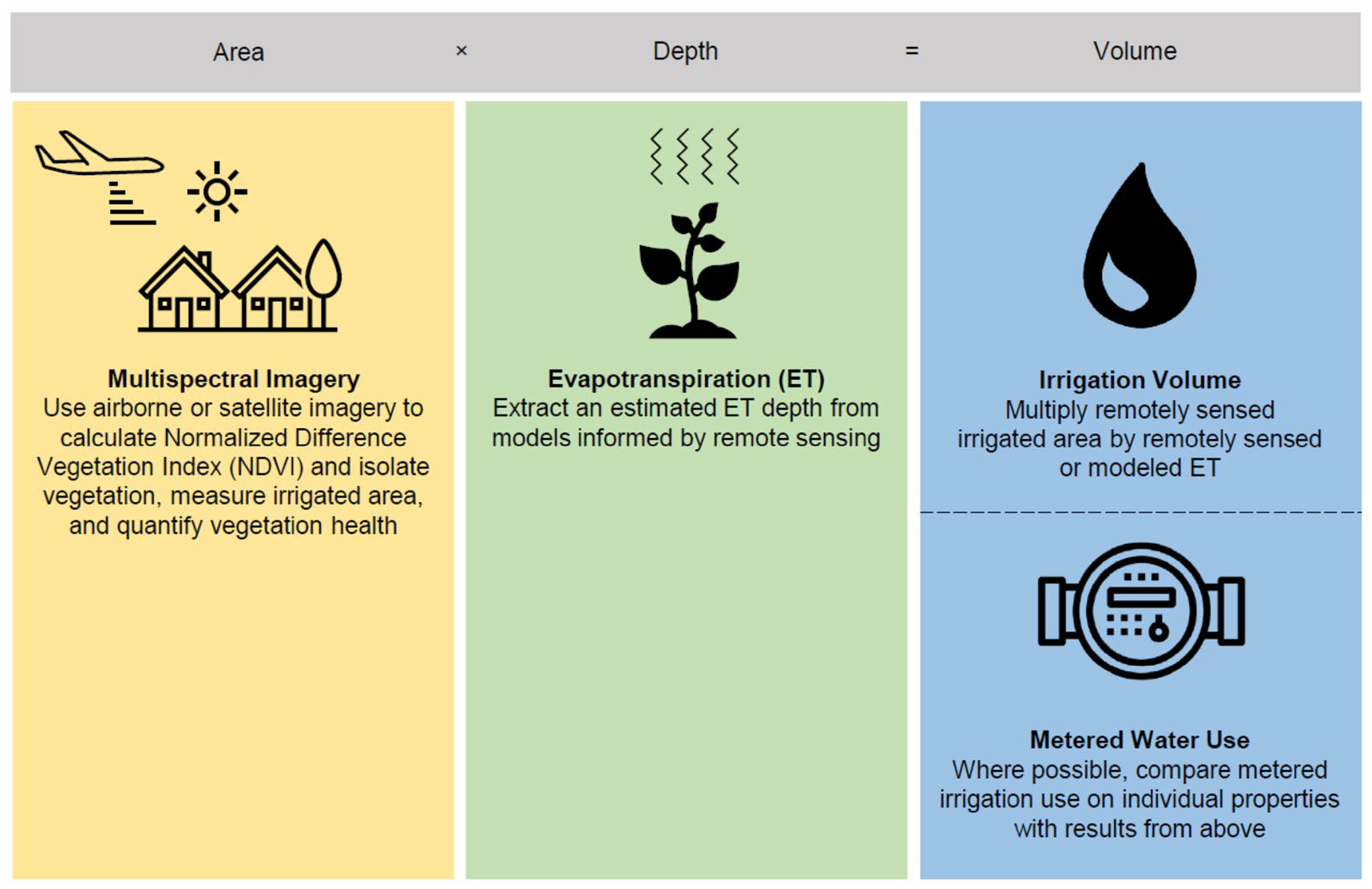
Within the area of interest, we chose eight study areas. Each study area included 35 to 75 individual property parcels, totaling 433 parcels across all eight. We determined the boundary of each study area according to how much area could be imaged in less than 30 min of drone flight. For ground truth, we collected multispectral drone imagery of our study areas. Drone imagery allowed us to analyze water use for a third time period, as we flew the drones in August and September in 2023.
The centroid of these study areas is at 112.08° W 41.19° N. Six of the eight study areas are within one NAIP image, while the other two are in NAIP images taken immediately after. Because the NAIP images were taken so close together, we ignore any changing conditions over the short time difference. In Figure 2, we show the placement of the eight study areas and their individual metered property parcels.

Figure 2.
Eight study areas within West Haven, Utah, with metered parcels.
2.3. Data
2.3.1. Aerial Imagery
Because we are analyzing small, irregularly sized parcels, high-resolution data are required. Capener et al. [16] evaluated imagery options and, based on their suggestions, we determined that the National Agricultural Imagery Program (NAIP) images best fit the needs of our study. NAIP imagery is publicly available and has sufficient pixel resolution (0.3–1.0 m) to allow for boundaries to be drawn between irrigated and non-irrigated areas. We used the USGS Earth Explorer website to retrieve NAIP images [19]. We retrieved the NAIP images for our parcels for two time periods: August 2018 and August 2021. We collected multispectral drone imagery in September and August of 2023 both to provide another data point for analysis and to serve as ground truth for the NAIP images. NAIP resolution was on the order of 0.6 m/pixel, while the drone imagery was 0.07 m/pixel.
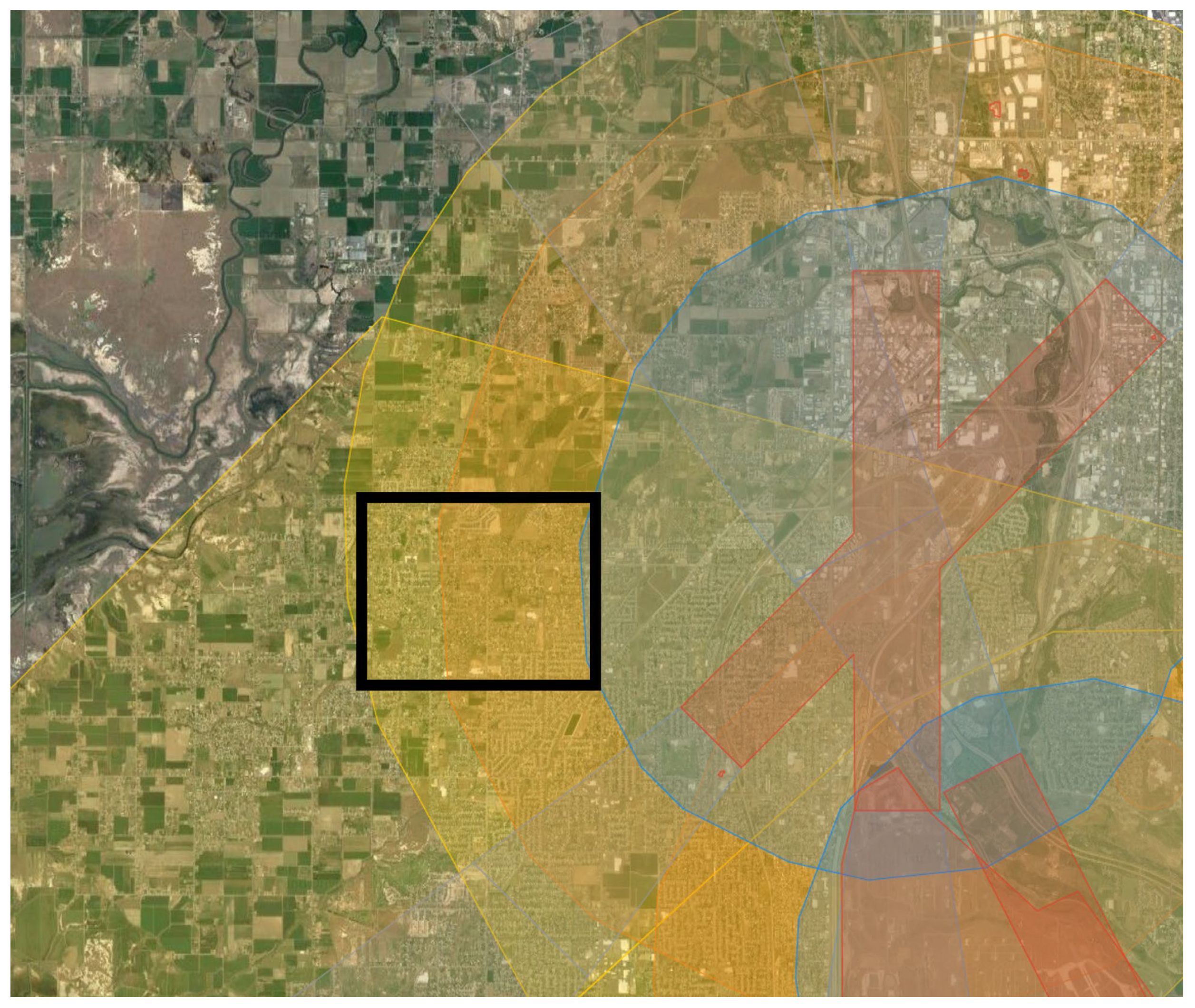
Because Weber County is home to Hill Air Force Base and Ogden-Hinckley Airport, many areas do not allow drone flights because of proximity to flight areas. We chose specific regions in our area of interest that were distant enough from these flight restrictions. Some parcels were in a restricted flight area that required permissions for flights. We received authorization to fly these areas from the Federal Aviation Administration (FAA) [20]. Figure 3 shows the GEO Zones as colors with our general study area in the black rectangle [20].

Figure 3.
Drone flight restrictions with our general study area (rectangle). The red region represents restricted zones, the blue region represents authorization zones, the orange region represents enhanced warning zones, and the yellow region represents warning zones.
We were approved to fly in the warning (yellow) and enhanced warning (orange) zones but did not receive approval to fly in the authorization (blue) zone because of its proximity to Ogden-Hinckley Airport.
We used a DJI Phantom 4 drone with a P4 Multispectral camera (DJI, Shenzhen, China). We collected images on 12 September and 19 September 2023 between 9:30 a.m. and 1:00 p.m. The camera collected data in 5 bands: red, green, blue, red edge, and near infrared (NIR) bands [21]. On our first day we captured images for study areas one, four, and three and on the second day we captured images for study areas two, five, six, seven, and eight.
We collected images from an altitude of 122 m (400 ft) with a speed of 20 km/h and 50% overlap between images. The overlap allows us to combine and process the images into a single mosaic for each study area (eight mosaics total). The overlap allows software to identify tie points between the images and correct for distortion. We selected the flight altitude as the maximum allowed by the FAA, to minimize flight times and the number of images generated, and to avoid potentially aggravating residents with the sound. Flying closer to the ground does result in higher resolution imagery; however, for our needs, the sensor at 122 m results in a nominal pixel resolution of about 7 cm which was sufficient for our study.
We processed the images using Pix4Dmapper version 4.8.4 which generates a single orthorectified 6-band image from individual drone images. We processed each of the eight study areas individually and exported the resulting orthorectified multiband images into ArcGIS Pro (version 3.1.2) for further analysis.
2.3.2. Water Use Data
We obtained secondary meter data from WBWCD for the water used on each parcel in our study. We were allowed to use, publish, and present findings based on these data but need to maintain the privacy of the WBWCD customers. We used publicly available parcel data from the Utah State Geographic Information Database (SGID) to geographically connect water use data to its respective parcel [22]. We used ArcGIS Pro to assign the irrigation efficiency adjusted Utah Climate Center reference ET data to each parcel. This provided GIS data with a 6-band image, boundaries, meter data, and ET value for each parcel.
We received monthly secondary water consumption (irrigation only) data from WBWCD, typically from the 16th to the 15th of every month. During instances of meter malfunction, we used the meter reading from the meter’s last good reading or when the meter was eventually fixed. This occurred only in about 50 of the 13,000 WBWCD meters every month. Because of the low frequency of meter malfunctioning, we did not adjust our data to account for potential malfunctions. Our four dates of interest (2018 NAIP image, 2021 NAIP image, and two days where drone flights were conducted) were within the four days of the 15th of their respective month.
We used the August water meter data to compare with the NAIP imagery and September water meter data to compare with the drone imagery. The water meter data were organized according to parcel ID number. We used these parcel IDs to connect the parcel location in ArcGIS Pro to the respective water meter data. To maintain the privacy of property owners, we do not list which parcel IDs were used, and we use an alternate numbering system.
2.3.3. Evapotranspiration Data
ET is specific to plant types, locations, and time of year and until recently, published, pre-computed ET data have been sparse, but new tools and data sources are becoming available. These tools include land surface models that use remote sensing data and produce gridded time-varying ET estimates [23]. OpenET, which averages the ET value of several well-known ET models for user-defined areas, is used by many researchers as it provides gridded data computed using established models. OpenET data are gridded on a 30 m grid. However, we found that it is difficult to use OpenET for urban irrigated areas because the ET value provided for a grid cell is not representative of the vegetated area, but the entire pixel which nearly always includes various impervious areas.
To explore the impact of this sub-pixel mixing, we compared OpenET values to the reference ET values from the Utah Climate Center we used in this study. We retrieved the ET water depth for the region encompassing our eight study areas from OpenET [24]. Because our water use data are for the 16th of the previous month to the 15th of the month of interest, we calculated the ET water depth by averaging the monthly ET values for both months. This means that for our August 2018 and August 2021 NAIP imagery, we averaged the ET values from July and August and for our September 2023 drone imagery we averaged our August and September ET values. We computed these averaged values for both the vegetive cover reference ET and the actual ET.
In Weber County, the monthly temperature between August and September varies. August has an average high of 28.3 °C and an average low of 16.7 °C while September has a high of 23.3 °C and a low of 12.2 °C [17]. We assume that the circumstantial differences between August and September are small enough that the NAIP imagery and drone imagery at all three times of interest can be compared. The ET values we used did account for these differences; the only difference would be in the irrigated area calculations where we expect little change.
We used Utah Climate Center reference ET data which give values for the reference crop [25,26]. We used values computed at the Utah Climate Center Eagle Lake station which is about 3 km from the center of our study area and provides hourly ET values [27]. We averaged the daily ET values for our three time periods of interest and then converted them to monthly ET values.
We compare the ensemble OpenET value of our eight study areas to the clipped grass reference ET values from the reference ET in Table 1. OpenET values are an average of the monthly data for listed months, reference ET data are an average of the daily values over the time period.

Table 1.
Comparison of monthly OpenET and reference ET water depths.
The actual OpenET values are significantly lower than the reference ET values because our study areas contain large impervious areas. Impervious areas have lower ET values than vegetated areas, making OpenET a bad option for finding ET estimations for landscaped sections of urban areas.
To estimate irrigation requirements, we modified the reference ET values to account for the inefficiencies of watering systems. We assumed that about 20% of the water applied will be lost to runoff or drift [28]. To account for this loss, we multiplied our ET values by 1.2 to generate estimated water requirements for our study parcels. Our final ET values, which we assume are the water amounts needed, are shown in Table 2.
Table 2.
Adjusted Reference ET values for three time periods.
2.4. Data Processing
2.4.1. NDVI Threshold Selection
The NDVI threshold value to represent the boundary between irrigated and non-irrigated areas varies in each scene. For example, in our study areas, there were several properties where gravel was placed and not irrigated, but weeds grew in the gravel area. NDVI, depending on the selected threshold, could classify the weeds as irrigated area because it contains vegetation, despite the area not necessarily being irrigated. A similar problem occurred on properties with un-landscaped areas containing dirt and non-irrigated vegetation. In either case, using too low of an NDVI threshold could result in an overestimate because it would capture areas with vegetation that is not irrigated.
NDVI can differentiate between pixels with vegetation and those without, but it does not necessarily differentiate between irrigated and non-irrigated areas. However, NDVI is sensitive to plant health, and we assumed that irrigated areas would have “greener” plants than non-irrigated areas.
This raises a challenge for selecting an NDVI threshold: a lower NDVI value may indicate non-irrigated vegetation or unwell vegetation. Unwell vegetation can occur for several reasons, from disease to underwatering or overwatering. We wanted to select a threshold to classify a pixel as either unwell vegetation or non-irrigated. We consider unwell pixels as irrigated but later use the values to assess irrigation efficiency.
This problem is prevalent for study areas that contain vegetation with a wide range of wellness levels. An example of this is included in Figure 4 below that shows a lawn area behind a house that has not been well cared for and the grass is dying. The grass is most likely irrigated but may be underirrigated. Figure 4 shows the impact of adjusting the NDVI threshold from 0.10 to 0.15 to 0.19 for the left, middle, and right panels on a 2018 NAIP image. Although the calculated irrigated area is not shown, it is apparent that the irrigated area changes with the threshold value.
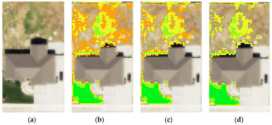
Figure 4.
Adjusting NDVI threshold values. (a) Base image without NDVI pixels. (b) Base image with 0.10 NDVI threshold value. (c) Base image with 0.15 NDVI threshold value. (d) Base image with 0.19 NDVI threshold value.
As in Figure 4, selecting a threshold value changes the result of the irrigated area even for a single property. Because of the range of vegetative wellness, it is difficult to determine which areas within the property are being irrigated. If we continue to lower the threshold, we can include the entire landscaped area; however, this will not give us an accurate estimate of irrigated area for the parcel. An added complication comes when determining a single threshold value for an image containing hundreds of parcels. One could choose threshold values for each property, but this requires significantly more effort and defeats the purpose of the automated approach. Because the drone images were taken at different times of day and have different sun angles that affect surface reflectance, we chose threshold values for individual sets of images.
In the selection of our threshold value, we needed to place the value low enough to account for lower NDVI values in shaded regions, as shown in Figure 5. In instances of shadow, it is common to see differences in vegetation index values [29]. Our experience is no different, with some shaded areas having NDVI values with values of 0.4 less than non-shaded regions, as can be seen in Figure 5. We did not encounter this in with NAIP imagery because of the sun angle when the images were collected and their lower resolution; however, it was prevalent in several of our drone images. Shadows could have been minimized if all images were collected at an optimal time of day. However, because we collected images for the eight study areas over two days, the time at which each set of images were collected varies.

Figure 5.
NDVI variations from shadows (top, base image; bottom, base image with NDVI overlay).
To account for shadowed vegetation and varying surface reflectance, we chose a unique NDVI value for each set of our 2023 drone images, i.e., one value for each study area. The threshold values that we selected for each aerial image are shown in Table 3 below.
Table 3.
NDVI threshold values for aerial imagery.
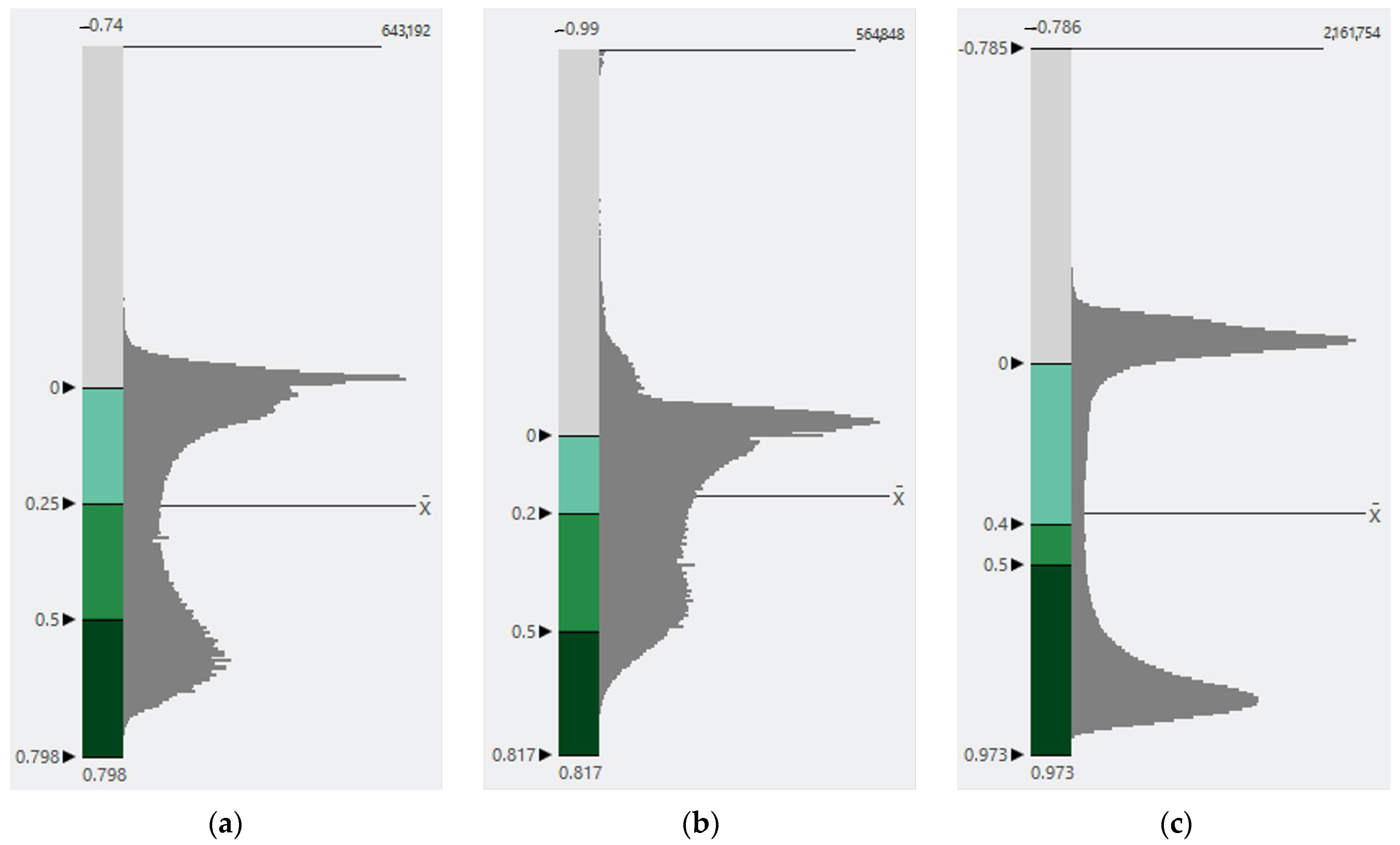
We performed a sensitivity analysis on the NDVI threshold value by adjusting the threshold for our 2018 NAIP imagery threshold. Table 4 shows the results. We found that even when shifting the threshold value by a large amount (0.05), the irrigated area changes by less than 6%. This suggests that the irrigated area is not particularly sensitive to the selected threshold and we consider subsequent results robust. Because the distribution of NDVI values is different for every image, shifting the NDVI threshold value may result in a larger change in irrigated area in some areas. For our three different image collection times, the number of pixels and NDVI values follow a similar distribution, as shown in Figure 6. In Figure 6, we marked the placement of the respective threshold value as well as other notable NDVI values.
Table 4.
Sensitivity analysis of NDVI threshold on 2018 NAIP imagery.
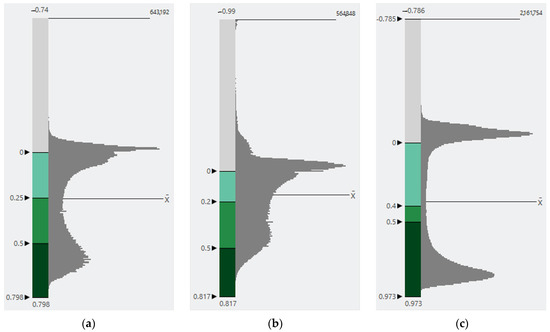
Figure 6.
(a) NDVI pixel count distributions for 2018, (b) NDVI pixel count distributions for 2021, (c) NDVI pixel count distributions for 2023.
There are two peaks in the distribution, one near 0 and again between 0.5 and 1. At 0 there is a peak in pixel count because of the large amount of impervious area in each image where the pixels have an NDVI value of 0, and again between 0.5 and 1 which is the value for pixels with healthy vegetation. It is in between these two peaks that we place our threshold value. The pixel count in this section of the distribution has a plateau; shifting the threshold value in either direction does not drastically change the total number of pixels on either side of the threshold or the associated area. Because every image is different in its mix of healthy and unhealthy vegetated area, the distribution will vary. In areas with more unhealthy vegetation, we expect the plateau value to be higher relative to the total pixel count within the image.
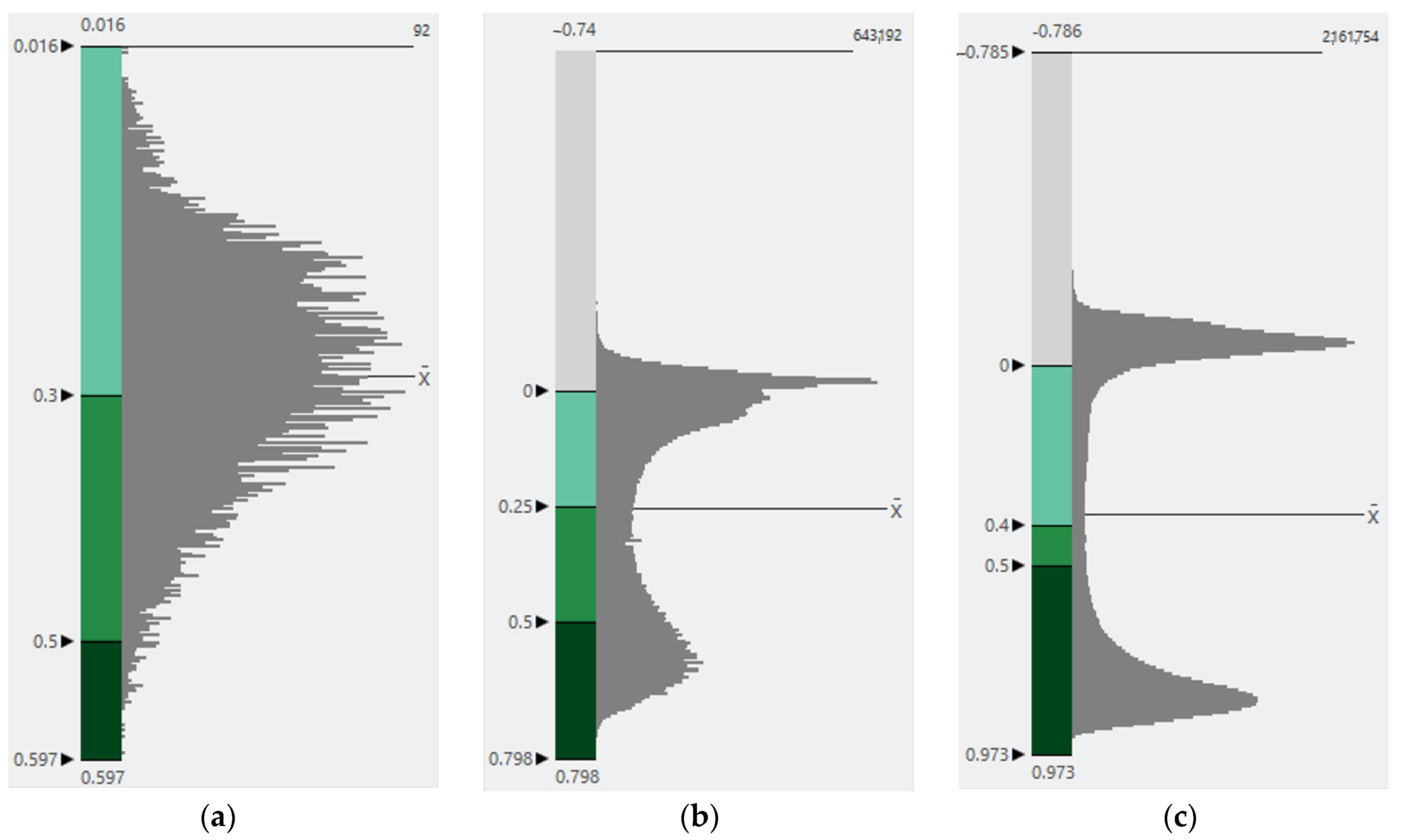
We hypothesize that because of the higher resolution of drone data, we can see a stronger trend in the distribution as the drone pixels are more likely to be “pure”, containing either all vegetation or all impervious or bare soil, while NAIP and satellite images are more likely to have mixed pixels, where many pixels contain both vegetation and soil. The processed mosaic of the 2023 drone image has a resolution of 6.7 cm (0.067 m), almost ten times higher than that of the NAIP imagery (0.6 m). This difference in resolution results in different numbers of mixed and pure pixels that explains why the peaks are more distinct in the 2023 drone images. To explore the impact of resolution on the distribution, we compared the NDVI distribution of a Landsat image taken on 18 August 2018 to our 2018 NAIP image and our 2023 drone image of study area one in Figure 7.
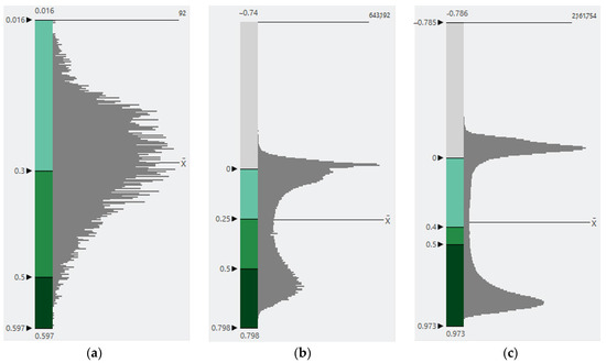
Figure 7.
(a) NDVI value vs. pixel count distribution of Landsat (30 m resolution), (b) NDVI value vs. pixel count distribution for NAIP (0.6 m resolution), (c) NDVI value vs. pixel count distribution of drone images (0.067 m resolution).
As the resolution of the image increases, the two-peak distribution becomes clearer. The image contains more pure pixels and fewer mixed pixels, and the plateau section tends to have a lower pixel count relative to the peaks. Accordingly, the selection of a threshold value is less sensitive to images of higher resolution. Because the sensitivity to adjusting the threshold for NAIP and drone imagery is low, the process that we follow in our research still produces meaningful results.
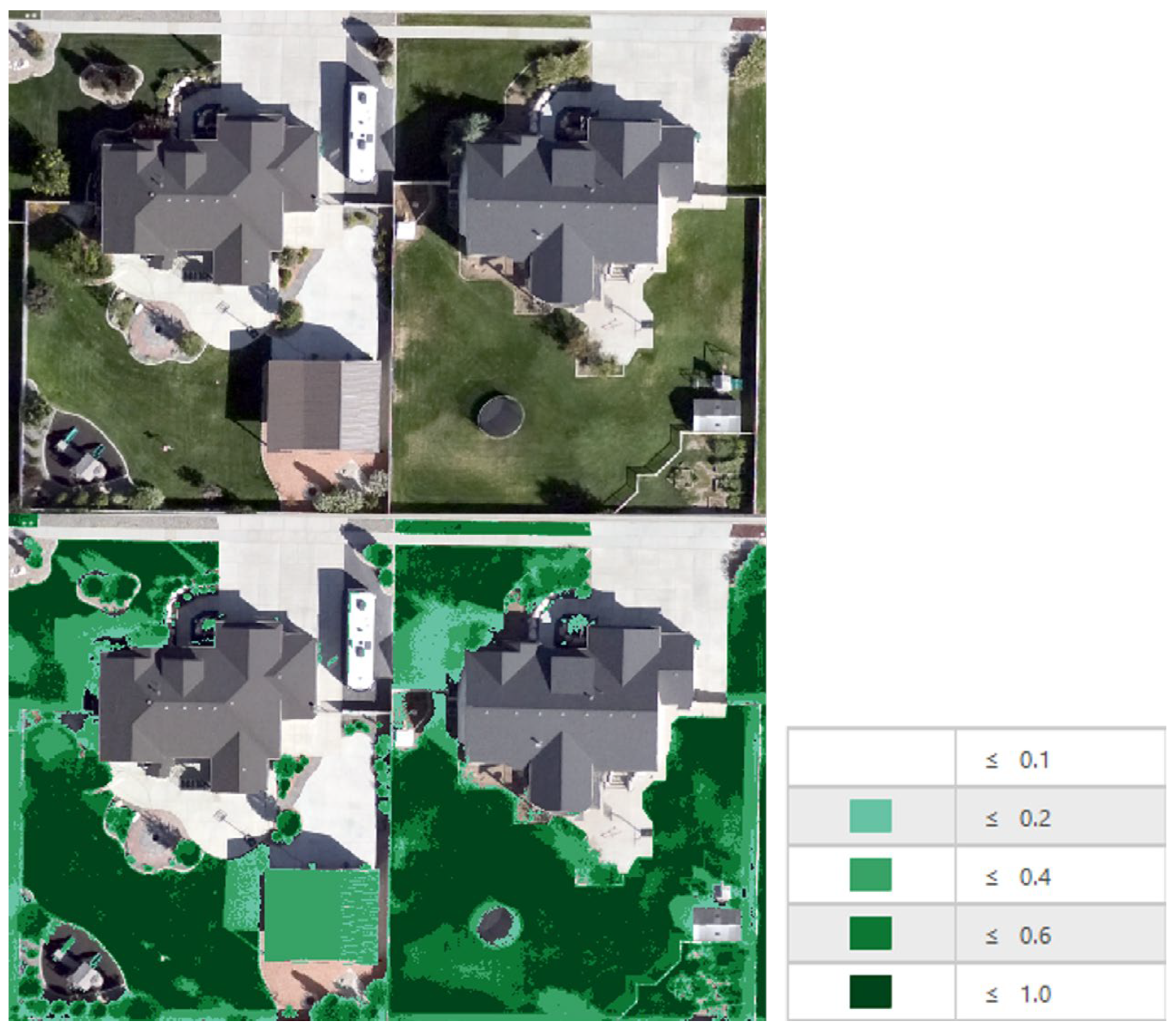
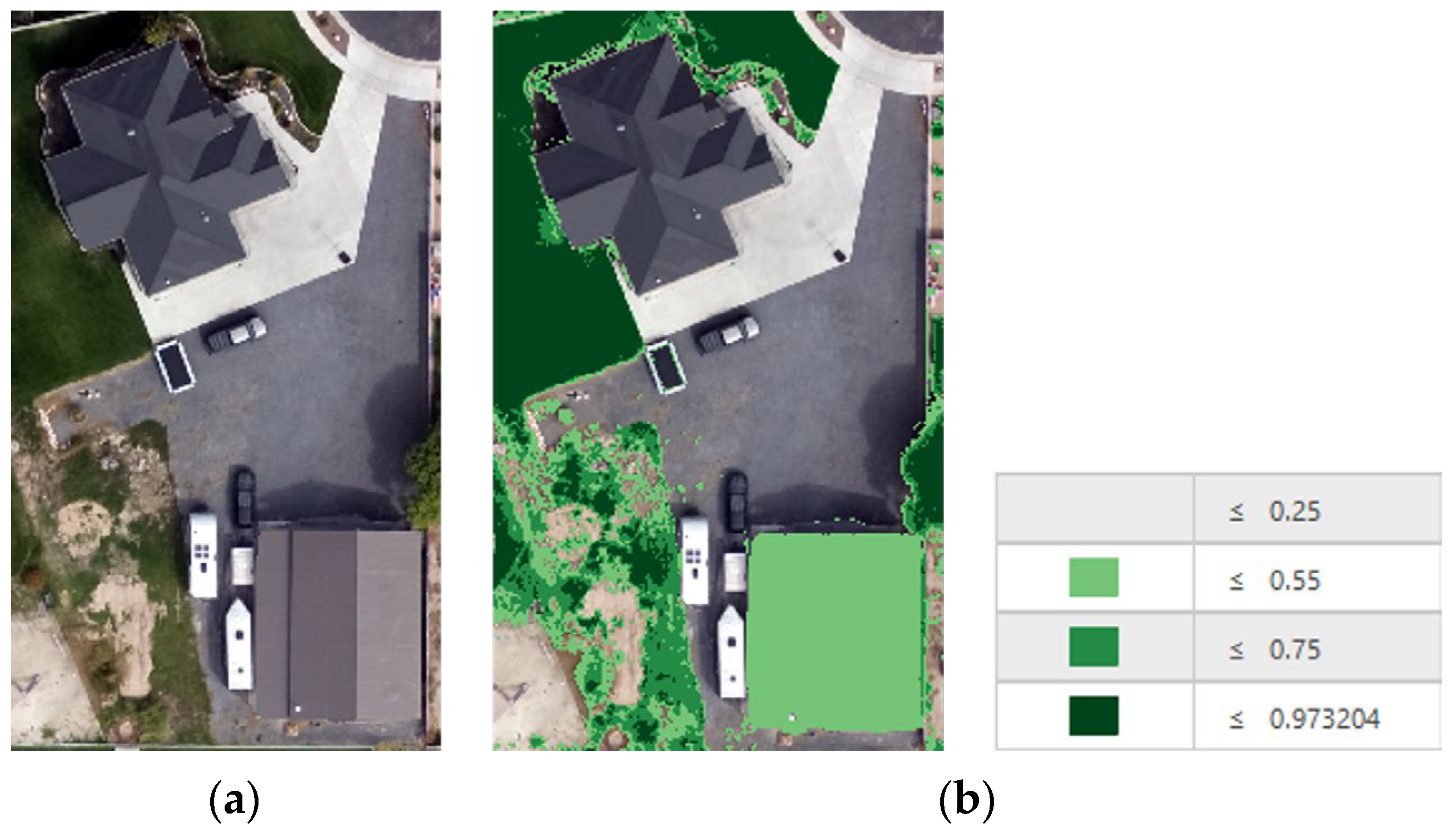
Another difficulty with choosing a threshold value is that occasional impervious areas would be included with the irrigated area. For our study area, this problem occurred for certain roofs that had NDVI values similar to vegetation (Figure 8).
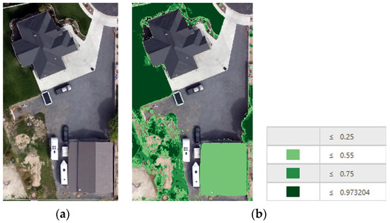
Figure 8.
(a) Base image, (b) base image with NDVI pixels and a legend, demonstrating that roofs are being classified as irrigated area.
This 2023 drone image is an example of a roof that was included with the irrigated area because its spectral profile matches that of vegetation. Since the NDVI values are the same, we could not use NDVI to identify and exclude these roofs. To exclude building roofs from the irrigated area calculations, we supplemented the NDVI spectral selection with object-based classification methods.
2.4.2. Quantifying Irrigated Area
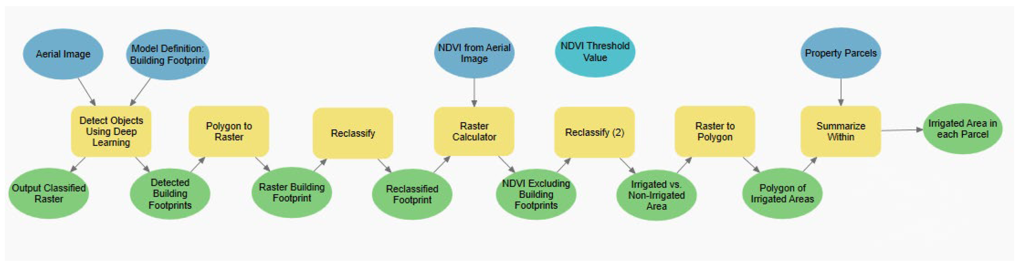
We created a model using ModelBuilder in ArcGIS Pro to expedite the repetitive process of determining irrigated area within each image. This process is shown in Figure 9. The blue ovals represent inputs required for the model to run. The darker blue ovals with arrows represent input files for the model, while the lighter blues without arrows represent values that need to be adjusted in the tool to meet the needs of the study area and image. The yellow rectangles represent ArcGIS Pro tools. The green ovals represent outputs from the various tools.
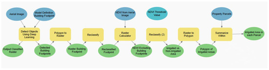
Figure 9.
ModelBuilder process used to measure irrigated area.
Moving through the model, we input the multispectral aerial image for our study area into the Detect Objects Using Deep Learning tool with our specified model being Building Footprint. This returned a shapefile with polygons representing the building footprints. We then converted the polygons to a raster image (with the same cell size as the aerial image) and fed the raster into the Reclassify tool. We reclassified the building footprint raster so all pixels representing building footprints would return “NODATA” while all non-building pixels would be classified as 1. With the Raster Calculator we multiplied the result by our raw NDVI raster, returning a new NDVI raster without building footprints. We then reclassified the raster so all pixels that had an NDVI lower than our chosen threshold value were given a value of “NODATA”, producing a new raster of only irrigated area. The reclassified raster was then converted to a polygon so we could apply the Summarize Within tool. The Summarize Within tool took the polygons and calculated how much irrigated area was within the polygon of each property parcel.
The final output of the model was a shapefile including the parcel ID and irrigated area (the area of pixels in the final raster). These data could then be paired with the gathered ET data to calculate the total volume of water needed to maintain plant health.
Some roofs and other materials have an NDVI value similar to vegetation. This means that we could not use NDVI to exclude these areas. The “Detect Objects Using Deep Learning” tool in ArcGIS Pro uses a third-party deep learning Python API to process a raster image [30]. Once the tool has completed its run, it returns a feature layer with polygons representing the classified image using different classification schemes.
Of the deep learning packages available, the one that addresses our needs is the “Building Footprint Extraction-USA” that is designed to identify structures in an image. We used this structural classification to differentiate roofs from the rest of the property and exclude them from the irrigated area calculations. This tool did not require us to provide training samples representing the different features within the image we wanted classified because it is already trained to extract building footprints. When performing a normal object-based classification, there were several unique objects, like pools and colorful cars, that confused the classifier (though a misclassification was not important because such objects should also have been excluded from the irrigated area if they had been included). By using the deep learning tool, we could expedite the process of identifying the structures in our images.
Once structures and their associated roof areas were defined, we could easily remove roof pixels from our total irrigated area computation. This helped us avoid inflating the irrigated area for our parcels.
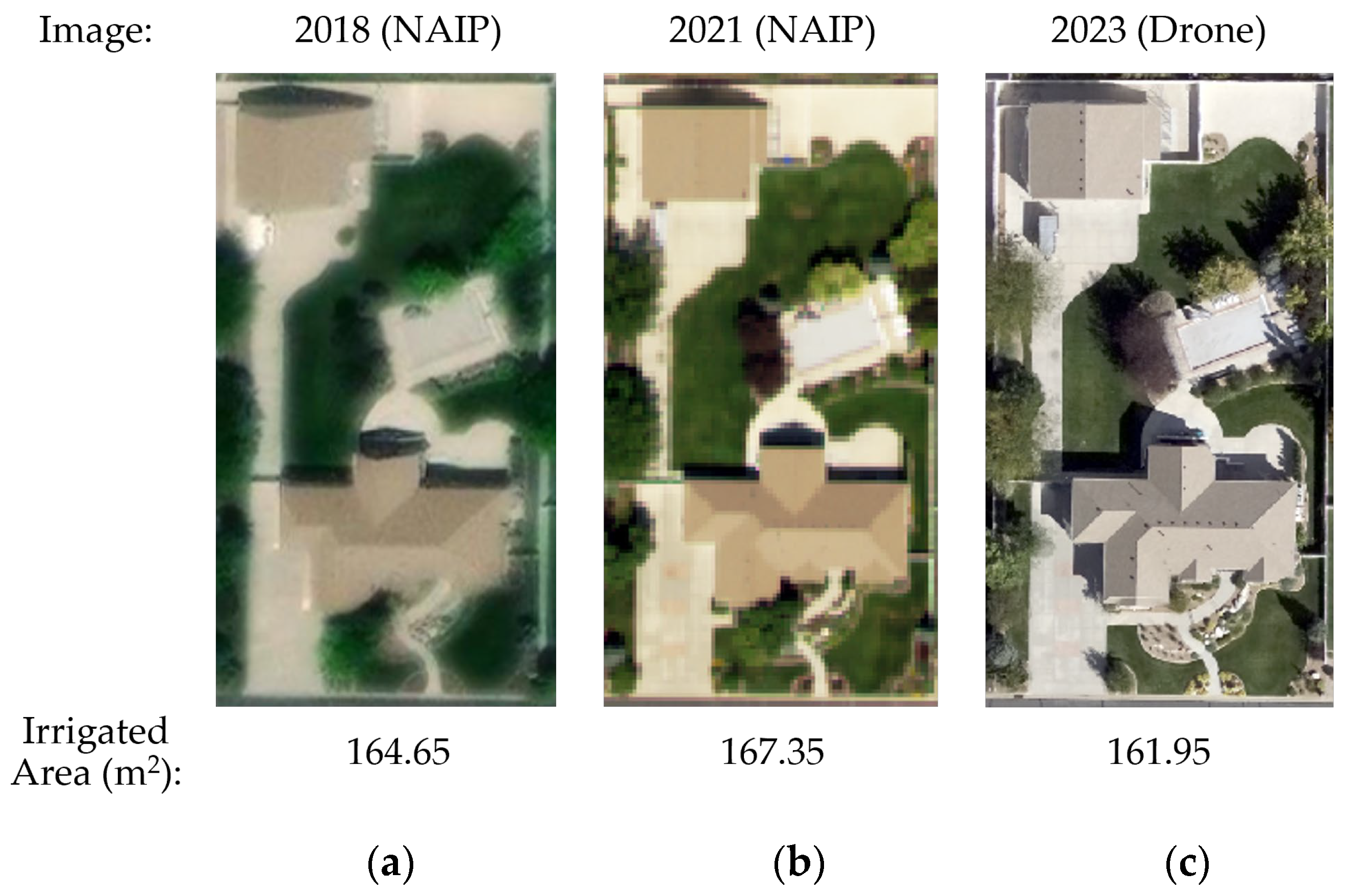
We did not find a meaningful variation in calculated irrigated area based on imagery type (NAIP vs. drone). We show this by comparing the irrigated area for a single parcel during the three time periods, which used NAIP and drone images. Figure 10 shows the change in irrigated area for the same parcel over the three time periods. This parcel was chosen because of the landscape design and plant health looked similar during three time periods. The 2018 and 2021 images are sourced from NAIP while that from 2023 comes from drone imagery. We find that the irrigated area is similar during all three time periods
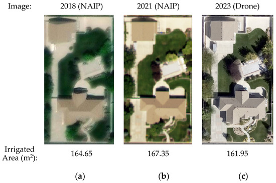
Figure 10.
Variation of irrigated area due to imagery type: (a) 2018 NAIP image and irrigated area, (b) 2021 NAIP image and irrigated area, (c) 2023 drone image and irrigated area.
We found this lack of variation to be true for imagery of high resolution (1 m or smaller). For Landsat and other low-resolution imagery, one cannot measure small irregular areas like urban landscapes.
2.4.3. Quantifying Irrigated Water Volume
Using the calculated irrigated area from the ArcGIS Pro ModelBuilder and the ET water depth from the nearby station, we found the volume of water necessary to maintain plant health by multiplying the irrigated area by the ET water depth for the respective time period. We converted the resulting water volume to gallons to compare with the WBWCD metered water values.
We calculated by how much users were overwatering by dividing the difference between the metered water volume (Mvolume) and the calculated AIRS water volume (AIRSvolume) and then dividing it by the AIRS water volume. We then multiplied this value by 100 to find the percentage of overwatering of each parcel, as shown in Equation (1).
To see the overall change in overwatering, we averaged the percentage of overwatering for all the parcels in each time period. In our results, we also grouped our data according to study area to see if the percentage of overwatering varied according to study area.
3. Results
3.1. Data Outliers
While interpreting the data, we found a few outliers for each time period. For some parcels, our results showed a few users watering upwards of 40,000% above the hypothetical water volume needed for the vegetated area. For each time period, there were never more than three outliers at a time (out of 433). We believe these large outliers could be caused by pipe leaks, billing errors, or undermeasurement of irrigated area rather than irrigation habits, so we exclude these outliers from further analysis. We did not use specific cutoff criteria to remove these points, but instead removed the points that were exceedingly larger than the rest. There is also the possibility that our data are being affected by water users using culinary water instead of secondary water to irrigate their landscape, which would appear in our analysis as underwatering. Because we do not know which users did this or the amount of culinary water applied, we cannot eliminate affected parcels from our dataset.
3.2. Urban Irrigation Efficiency
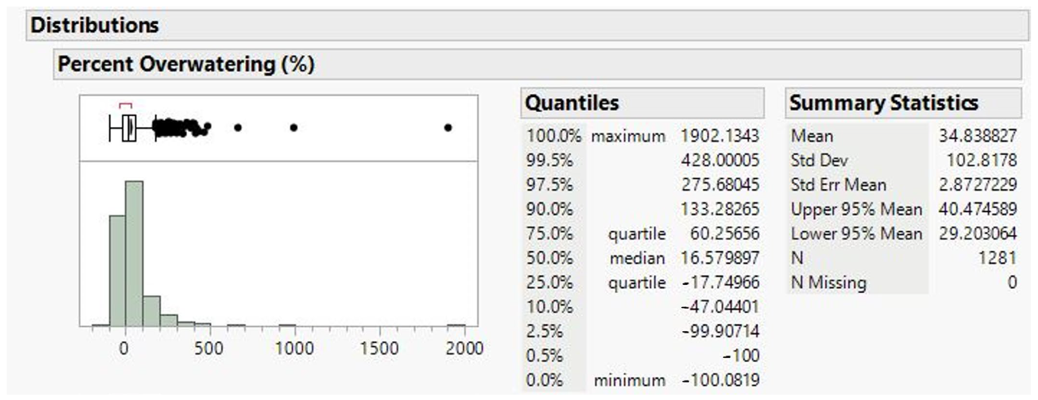
All three time periods showed that, on average, 64.4% of property owners were overwatering.
Table 5 shows that water users are overwatering by 16.6% at the median. The distribution is left skewed with a few users significantly overwatering, resulting in a mean overwatering amount of 34.8%. Figure 11 shows a distribution of the percentage of overwatering, Figure 12 shows the distribution of overwatering grouped by study area. This figure shows that at the 75% quartile, 60.3% of parcels are overwatered, while at the 25% quartile, 17.7% of the parcels are actually underwatered. The red bracket in Figure 11 represents the shortest interval that contains half the data, and this bracket lies mostly on the underwatering portion of the graph. These data are based on individual parcels and not on total water use or size of the parcel.
Table 5.
Average water volume trends of three time periods overall.
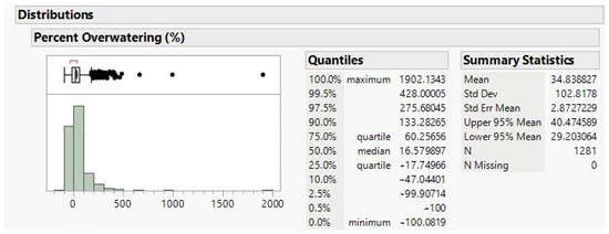
Figure 11.
Distribution of percentage of overwatering for all parcels.
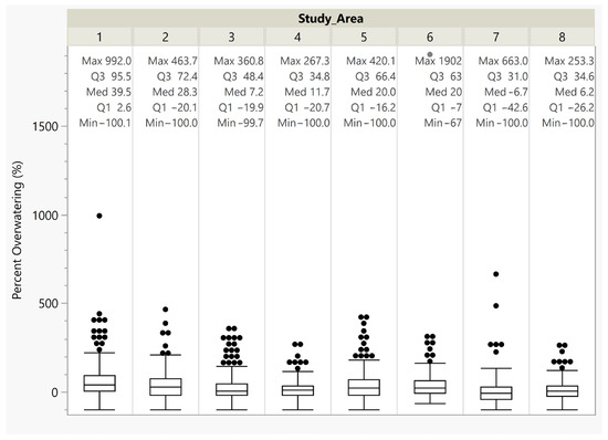
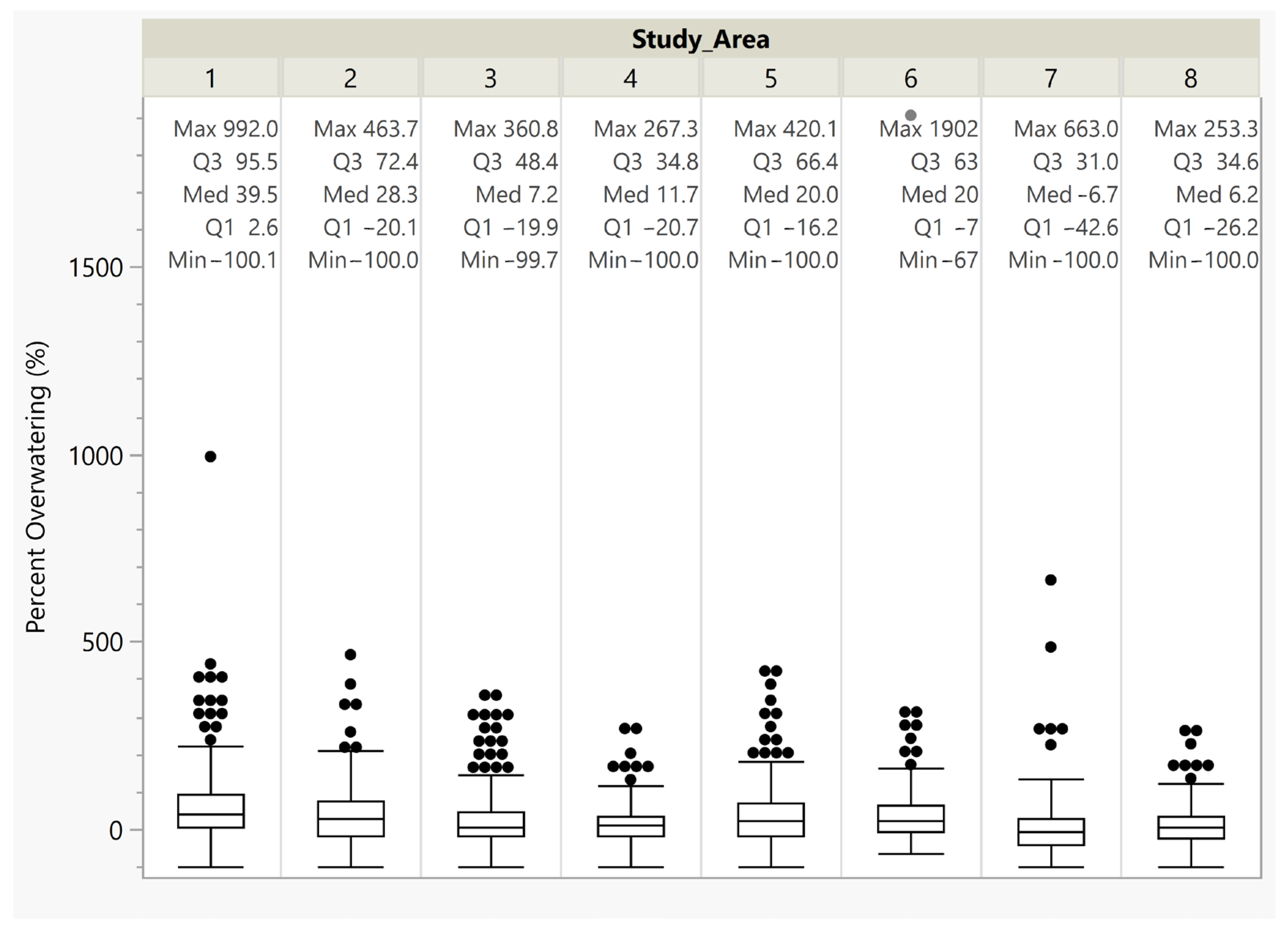
Figure 12.
Percentage of overwatering grouped by study area.
Figure 12 shows that for the eight study areas, the median amount by which users are overwatering ranges from 39.5% to −6.7%. Only two areas, Area 1 and Area 2, have median overwatering rates greater than 20%, two have median values of 20%, and the remaining four have overwatering rates between 11.7% and −6.7%. We did not perform an uncertainty analysis, but we expect that 10% to 20% is well within the range of error. All but one area, Area 1, has 25% of the parcels underwatered and Area 1 only has an overwatering rate of 2.6%. The box-and-whisker plots show that the data from all the areas are left skewed with several outliers (black dots) larger than 1.5 times the interquartile range.
3.2.1. Year-to-Year Analysis
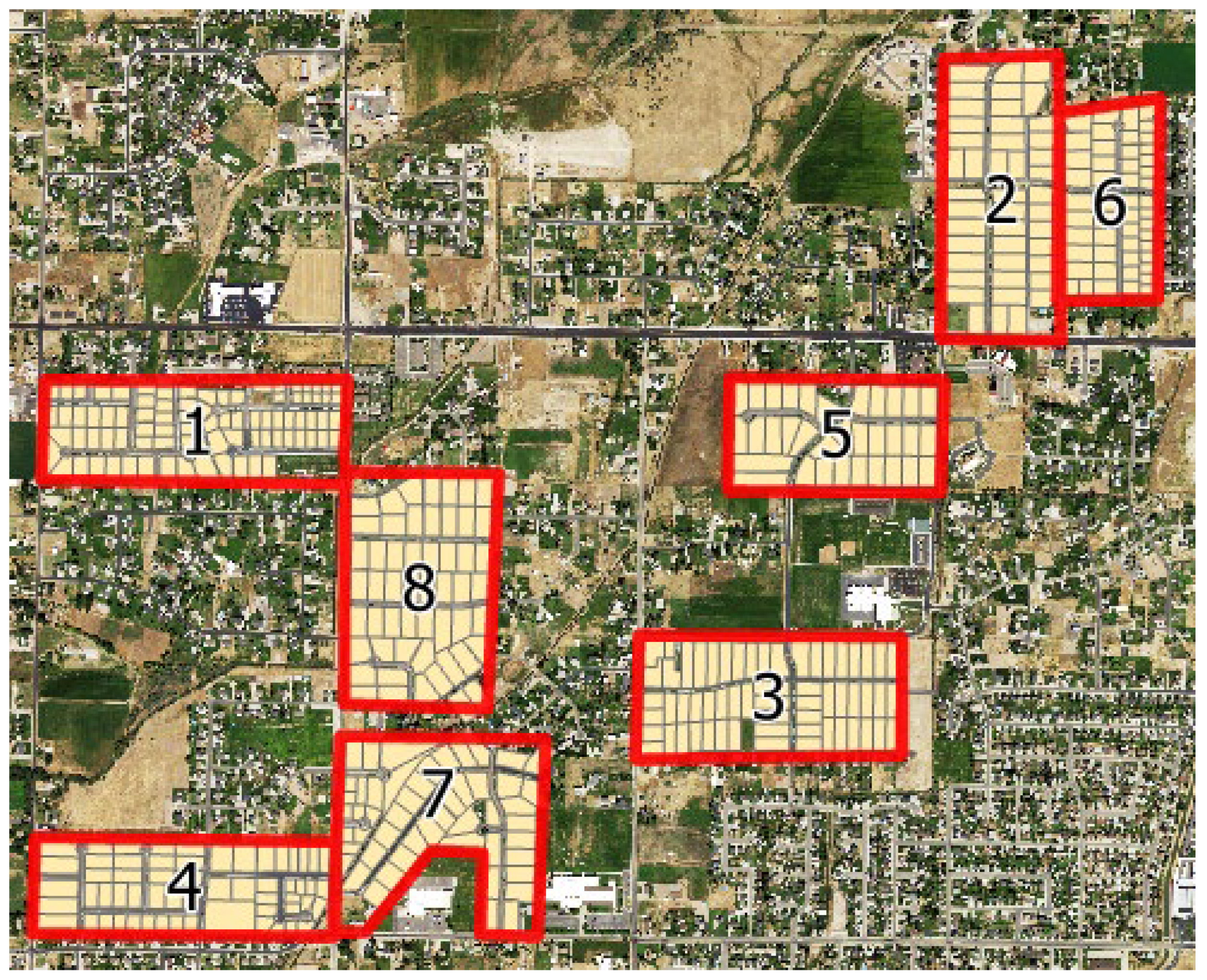
We hypothesize that with the increased awareness of urban irrigation practices, smart controllers, and publicity regarding Utah’s water supply, we expect that water users are conserving more [31]. The trends that we found for our eight study areas over 2018, 2021, and 2023 are shown below in Table 6 and Figure 13.
Table 6.
Average water volume trends of the three time periods individually.

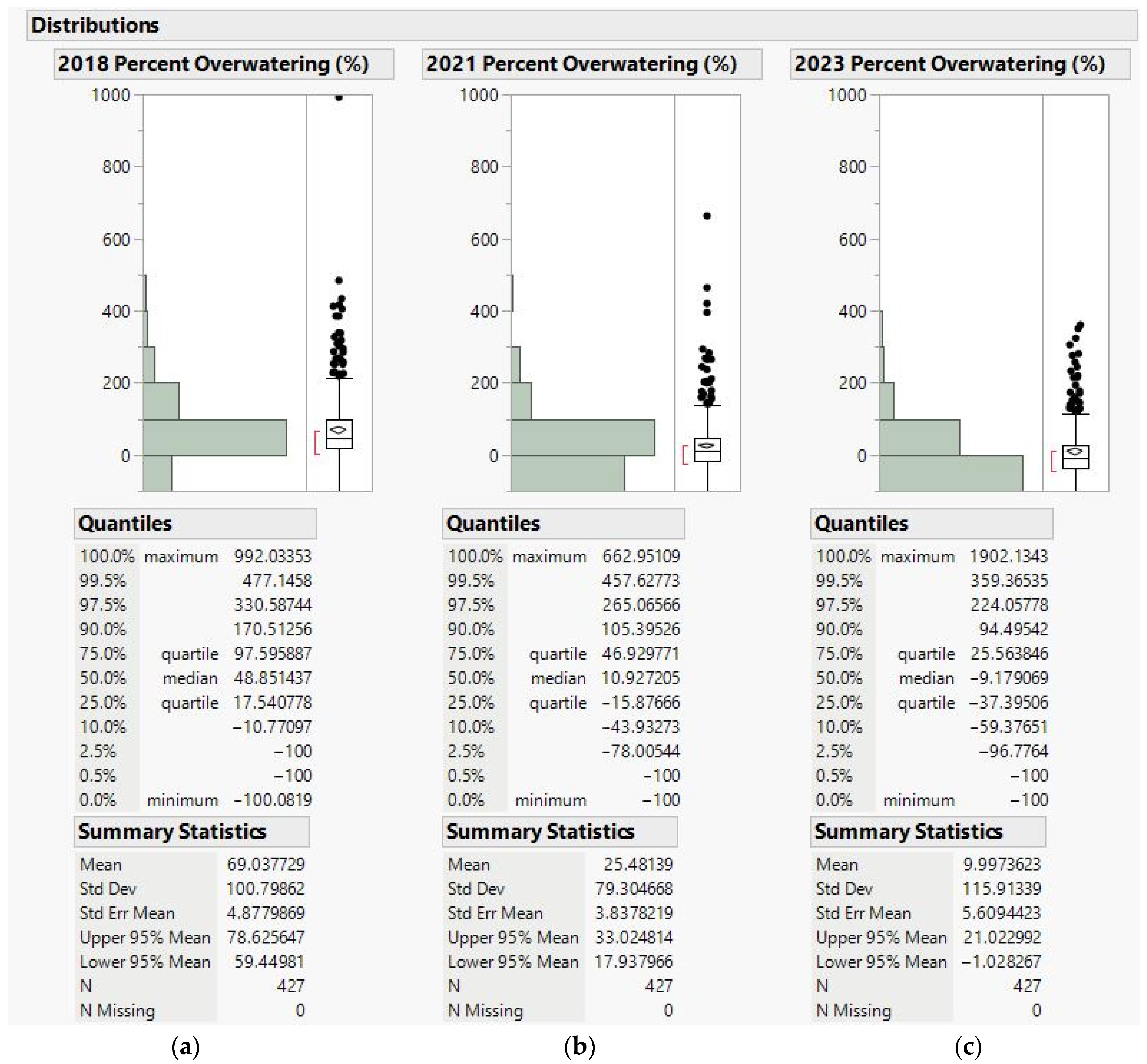
Figure 13.
(a) Changes in percentage of overwatering during 2018, (b) Changes in percentage of overwatering during 2021, (c) Changes in percentage of overwatering during 2023.
We found that the amount by which people are overwatering is decreasing with time, as can been seen by the decrease in both mean and median. The 2023 data are looking at September instead of August, which contributes to the values being lower than the 2018 and 2021 values. Differences in precipitation for each time period could also impact the change in mean and median watering rates.
3.2.2. Lot Size Analysis
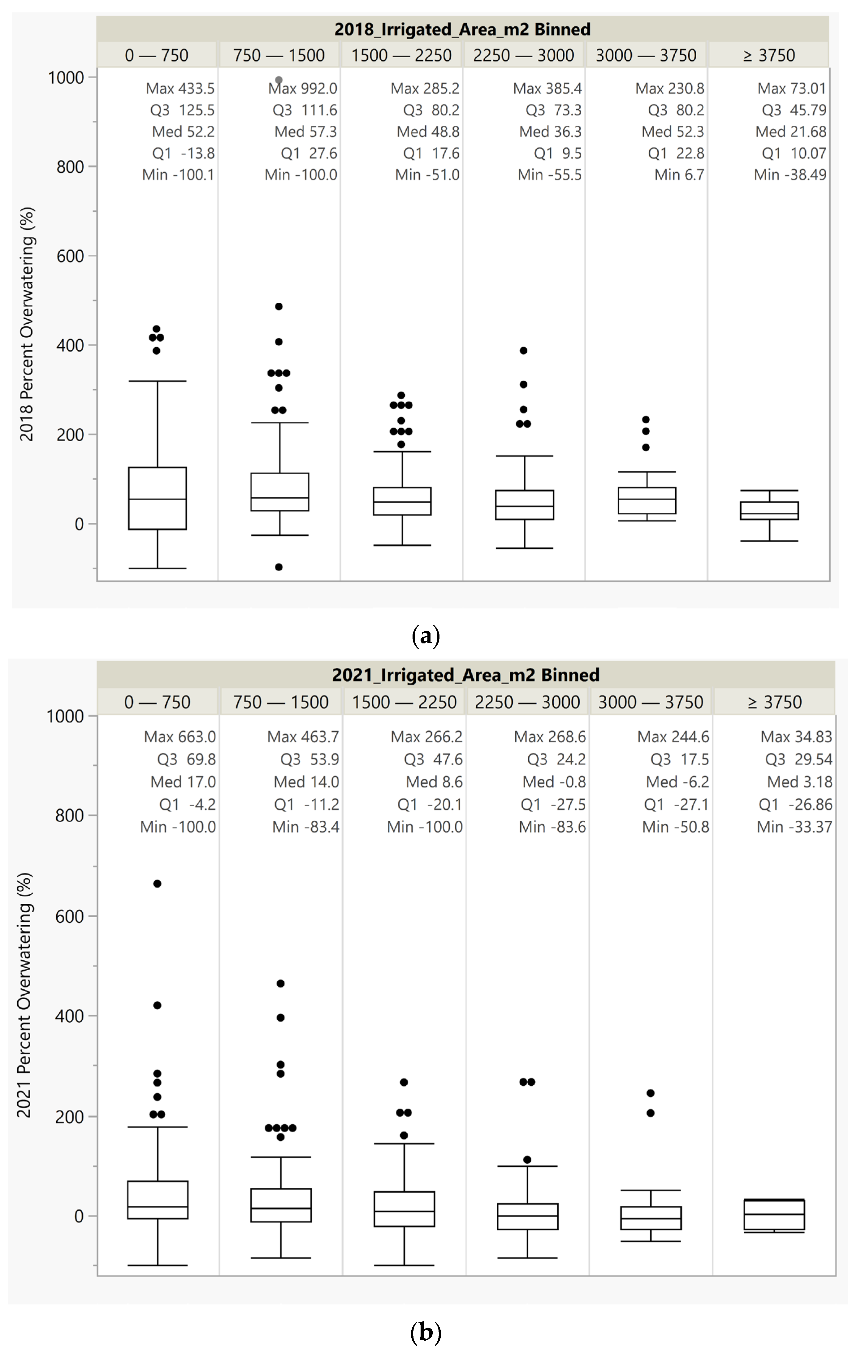
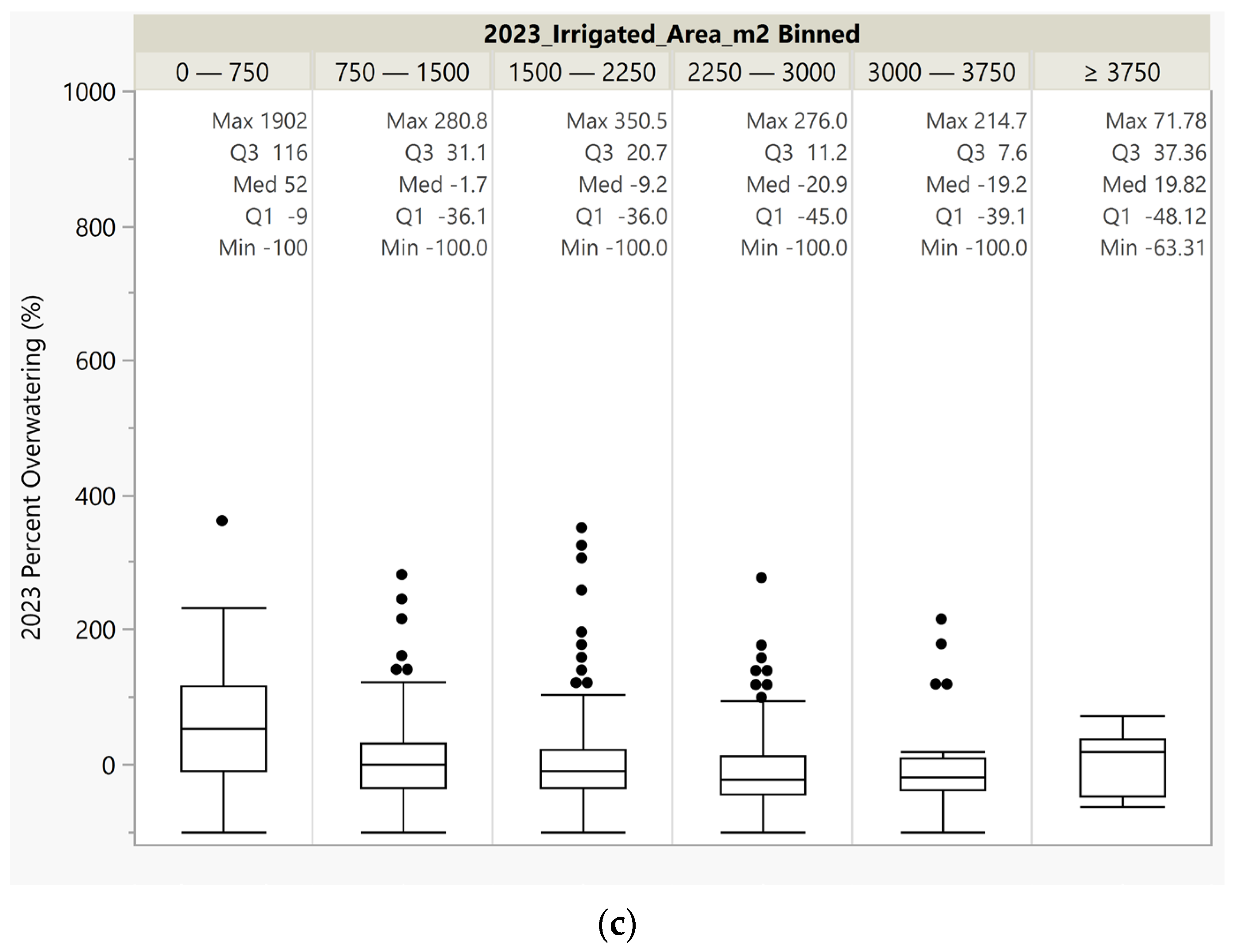
In the first two study periods Figure 14 shows that, at the median, all lot sizes are overwatered by about 50% apart from the largest lots which, at the median, were overwatered by about 20% and 30% for 2018 and 2021. In 2023, the final study period, Figure 14 shows that except for the smallest lots (0 to 750 m2) and largest lots (>3750), all are underwatered at the median level. For all these groups, except the smallest, the 75th percentile user is only overwatering by a small percentage, probably within the margin of error for our study. The 75th percentile values decline with lot size from about 30% to 7.6%. The data are interesting because most lots are overwatered in the first two periods, when rainfall was very low, but watered approximately the correct amount in 2023 when there was more rainfall. Except for the smallest lot size, all the other lot sizes seemed to adjust for the additional rainfall, while the smallest lot sizes stayed about the same.
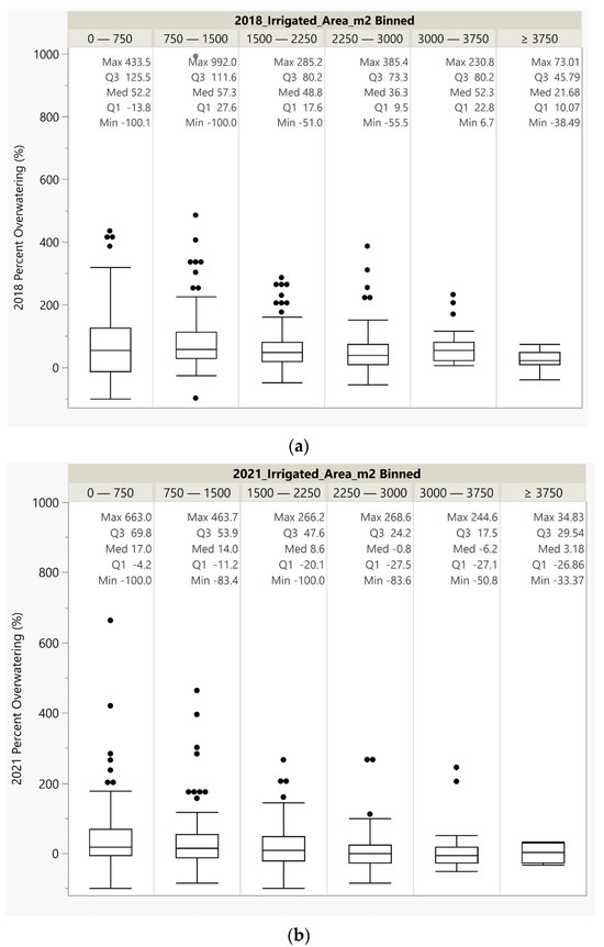
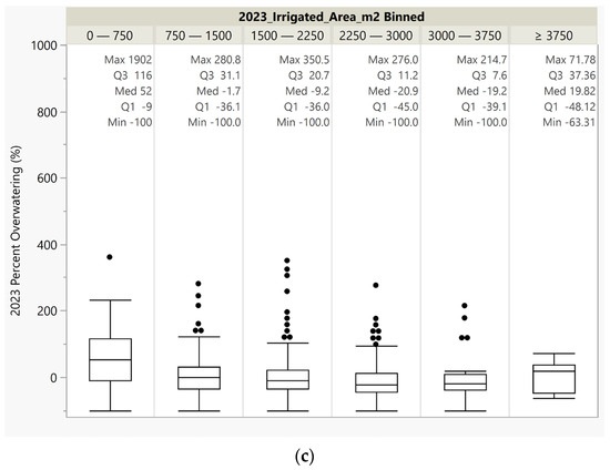
Figure 14.
(a) Irrigated area vs. percentage of overwatering for 2018, (b) Irrigated area vs. percentage of overwatering for 2021, (c) Irrigated area vs. percentage of overwatering for 2023.
4. Discussion
We hypothesized that most property owners applied more water than necessary to their yards. Our estimation of 64% of users overwatering is consistent with the findings of a similar study in Zaragoza, Spain which found 60% of users overwatering [9]. We assumed this because most property owners have not received training for watering practices and because of typical irrigation system efficiency and installation difficulties. We also anticipated that the gap between the actual and hypothetical water used would decrease with time. This is because of the growing popularity of smart controllers and potential replacement of aging sprinkler systems. We also assumed that, with the passage of time, property owners would have more opportunities to learn and implement water-saving practices. We also anticipated outliers in the population both in over- and underwatering levels.
4.1. Limitations
Our analysis of the results is limited by our assumptions and lack of information for our study area. Despite the low sensitivity of adjusting the NDVI threshold, we still needed to select a value. This is a limitation of the certainty of our results. We selected entire neighborhoods, rather than only parcels with clearly defined irrigated areas. We assumed that we could quantify irrigated area based on NDVI values. Some data points were obvious errors, due to either pipe leaks or billing errors, however, the results had a skewed distribution, so knowing whether the higher users were outliers or just high users added some uncertainty. Our results are also uncertain because of potential minorly incorrect parcel boundaries, which could have caused us to incorrectly calculate the irrigated area.
While the data show decreasing amounts of overwatering over time, we cannot directly attribute this trend to more conservation or sustainable use as other factors could impact water use. For example, at the Pleasant View–Thinnes Orchard weather station for 2018 there was 1.52 and 0.0 mm of rain in July and August, for 2021 there was 4.57 and 45.21 mm for July and August, and for 2023 there was 32.77 and 12.45 mm of rain for August and September, respectively [32]. These data show that July and August of 2018 were very dry—essentially no rain—while in 2021 there was little rain in July with good rain in August, but this rain was from the 18th to the 21st of the month or later in the month. In 2023, the month preceding the collection, August, had 32.77 mm of rain, with 12.45 mm before the 5th. This difference in the amount and timing of precipitation may well explain the decreasing trend in water application we observed. Even while ignoring rainfall in our calculations, many properties are grossly overwatering.
4.2. Recomendatations
We recommend several adjustments to reduce subjectivity and maximize findings in future applications. Because we collected our drone images at different times of the day, the NDVI values vary due to changing shaded regions [29]. We would recommend flying drones at the same time over several days, when the sun is directly overhead and shadows are minimized.
The research process could also be simplified by only studying areas that appear to have predominantly healthy vegetation and are irrigated regularly. Because we studied entire neighborhoods containing properties with a range of vegetative wellness, it was more subjective to choose an NDVI threshold value. If all areas appeared to be well irrigated, we would not have needed to decide at which NDVI threshold the vegetation was unhealthy versus not receiving water. We also could have maximized our findings by receiving water use information from more than just the water utility.
If we had contact with the water users along with the water utility, we could have compared the efficiency of different watering systems and practices. This would have also allowed us to ask about their history of pipe leaks and if they are using culinary water for irrigation. This information would confirm or deny the assumptions we made regarding extreme water meter values. Having contact with the water users would allow us to analyze the data more thoroughly and could produce interesting findings. Accounting for precipitation volume would also be beneficial to more accurately estimate overwatering.
The over- or underwatering results are specific to our case study in Weber County, Utah, but the image analysis techniques are generally applicable. We found that the AIRS process produces valuable findings for water utilities. AIRS could allow the utility to see if their water conservation initiatives impact users’ irrigation efficiency. Much of the data we used—NAIP images, OpenET, local ET data—are publicly accessible and the AIRS approach can be implemented without coding experience. To exclusively use OpenET in the AIRS process, research is needed to determine if there is a calculation that could be performed on OpenET data to allow it to represent urban areas. Using the AIRS process could assist in locating which areas are most susceptible to overwatering and focus conservation efforts accordingly. Previous studies have shown that users with larger parcels or irrigated areas tended to water more efficiently [4]. Our findings support this conclusion (Figure 14). This finding supports the idea that water utilities should focus their water conservation efforts on those properties with small landscaped areas where overwatering is more common.
Changes in Utah legislation will allow AIRS to be performed more widely. In April 2022, only 15% of secondary connections in Utah were metered [15]. This limited the area in which we could perform AIRS. However, because of Utah’s 2022 legislation requiring all secondary connections to be metered before 2030, this process can soon be performed across the entire state [15].
Despite the increase in secondary meters, the ability to perform AIRS is limited by the aerial imagery available. NAIP is a great source of imagery, however; images are only collected every few years during late summer. One cannot compare how irrigation efficiency is changing monthly in a given year when using NAIP, which makes it difficult to see changes over small time periods. Because of the NAIP schedule, we can see how water use habits change about every three years, which is still useful information. Water utilities may also use drones to capture their own images of individual neighborhoods. Although one can capture drone imagery of an entire city to perform AIRS, this would require a lot of time, resources, and processing power. Instead, we would recommend that a utility selects neighborhoods dispersed throughout their area of interest to perform AIRS on, or perhaps focus on irrigated open spaces like parks and school grounds. Processing a smaller set of images is more feasible and would allow the process to be repeated often. Information gathered through the AIRS process could supplement a utility’s water use report and provide valuable insight into changes in water users’ habits.
5. Conclusions
By performing this research in Utah, we are bringing attention to this remote sensing process (AIRS) and its ability to help in Utah’s efforts to conserve water. Although there are existing publications where this process is defined, they do not use the same high-resolution multispectral imagery that we use [3]. AIRS can assist water utilities in tracking the irrigation efficiency of water users over time, without requiring large amounts of time or computation power. In our study of Weber County, Utah, we estimated that 64% of users are overwatering by 35% (according to the mean) or 17% (according to the median) on average during the three time periods that we studied. Because of the increasing installation of secondary meters in Utah due to the 2022 legislation, it will soon be possible to perform AIRS anywhere in the state [15]. Because of the complex water resources problem in throughout the western United States, this process can be helpful for water utilities in focusing their efforts on encouraging water conservation.
Beyond its applications in Utah, general research value arose from this study in terms of image analysis. First, we found that calculating irrigated area for urban landscapes is acceptable when multispectral image resolution is finer than about 1 m. Our drone images with 0.07 m resolution did not produce significantly different irrigated area than NAIP images with 0.6 m resolution. Second, we found that identifying irrigated urban areas using NDVI becomes less sensitive to the user-selected NDVI threshold as the image resolution increases. For low-resolution images (e.g., 30 m Landsat), NDVI tends to cluster in a single peak; for high-resolution images (e.g., NAIP and our drone), NDVI tends to spread into two distinct peaks, and vegetation is one of them. Third, we found that identification of urban irrigated areas can be enhanced by combining NDVI with other tools such as building footprint extraction, object classification, and deep learning.
Author Contributions
Conceptualization, R.B.S., G.P.W. and A.M.T.; methodology, A.M.T., R.B.S., G.P.W. and N.C.H.; software, A.M.T.; validation, R.B.S., G.P.W. and N.C.H.; formal analysis, A.M.T.; investigation, A.M.T.; resources, A.M.T. and R.B.S.; data curation, A.M.T.; writing—original draft preparation, A.M.T.; writing—review and editing, R.B.S., G.P.W. and N.C.H.; visualization, A.M.T.; supervision, R.B.S.; project administration, R.B.S.; funding acquisition, R.B.S. and G.P.W. All authors have read and agreed to the published version of the manuscript.
Funding
The research was partially funded by the U.S. Geological Survey through the Utah Center for Water Resources Research under the USGS 104(b) Competitive Research Grants Program (award G21AP10623, sub-award 203840-860). Drone activities occurred under other funding.
Institutional Review Board Statement
Not applicable.
Informed Consent Statement
Not applicable.
Data Availability Statement
For the privacy of Weber Basin Water Conservancy District water users, we will not share the data used in the study.
Acknowledgments
We would like to acknowledge Arianna Young for her work in collecting and processing the drone images used in this research. We would also like to thank the BYU Civil and Construction Engineering Sustainability Lab for providing the computer and working space for this research.
Conflicts of Interest
The authors declare no conflicts of interest.
References
- USGS. NDVI, the Foundation for Remote Sensing Phenology. Available online: https://www.usgs.gov/special-topics/remote-sensing-phenology/science/ndvi-foundation-remote-sensing-phenology#overview (accessed on 1 November 2022).
- Dieter, C.A.; Maupin, M.A.; Caldwell, R.R.; Harris, M.A.; Ivahnenko, T.I.; Lovelace, J.K.; Barber, N.L.; Linsey, K.S. Estimated Use of Water in the United States in 2015; U.S. Geological Survey: Reston, VA, USA, 2018. [Google Scholar] [CrossRef]
- Johnson, T.D.; Belitz, K. A remote sensing approach for estimating the location and rate of urban irrigation in semi-arid climates. J. Hydrol. 2012, 414–415, 86–98. [Google Scholar] [CrossRef]
- Shurtz, K.M.; Dicataldo, E.; Sowby, R.B.; Williams, G.P. Insights into Efficient Irrigation of Urban Landscapes: Analysis Using Remote Sensing, Parcel Data, Water Use, and Tiered Rates. Sustainability 2022, 14, 1427. [Google Scholar] [CrossRef]
- Sowby, R.B.; Lunstad, N.T. Why Is Residential Irrigation So Hard to Optimize? Water 2023, 15, 3177. [Google Scholar] [CrossRef]
- Hilaire, R.S.; Arnold, M.A.; Wilkerson, D.C.; Devitt, D.A.; Hurd, B.H.; Lesikar, B.J.; Lohr, V.I.; Martin, C.A.; McDonald, G.V.; Morris, R.L.; et al. Efficient Water Use in Residential Urban Landscapes. HortScience 2008, 43, 2081–2092. [Google Scholar] [CrossRef]
- Nouri, H.; Beecham, S.; Kazemi, F.; Hassanli, A.M. A review of ET measurement techniques for estimating the water requirements of urban landscape vegetation. Urban Water J. 2013, 10, 247–259. [Google Scholar] [CrossRef]
- Mini, C.; Hogue, T.S.; Pincetl, S. Estimation of residential outdoor water use in Los Angeles, California. Landsc. Urban Plan. 2014, 127, 124–135. [Google Scholar] [CrossRef]
- Salvador, R.; Bautista-Capetillo, C.; Playán, E. Irrigation performance in private urban landscapes: A study case in Zaragoza (Spain). Landsc. Urban Plan. 2011, 100, 302–311. [Google Scholar] [CrossRef]
- Harris, E. State and County Population Estimates for Utah: 2020. Inf. Decis. 2020. [Google Scholar]
- Sowby, R.B. Utah Is Not the Second-Driest State: A Lesson in Questioning Persistent Assumptions about Hydrology. J. Hydrol. Eng. 2024, 29, 02523001. [Google Scholar] [CrossRef]
- Utah Department of Natural Resources. Recent Updates (as of 11/30/23). Available online: https://drought.utah.gov/#:~:text=Last%20year%2090%25%20of%20the,year’s%2041%25%20at%20this%20time (accessed on 11 December 2023).
- Sanchez, M. Utah Water Conditions Update. 2023. Available online: https://water.utah.gov (accessed on 3 October 2024).
- Utah Department of Natural Resources. Slow the Flow. Available online: https://slowtheflow.org/ (accessed on 22 March 2024).
- Utah Legislature, H.B. 242—Secondary Water Metering Amendments. 2022. Available online: https://le.utah.gov/~2022/bills/static/HB0242.html (accessed on 23 October 2024).
- Capener, A.M.; Sowby, R.B.; Williams, G.P. Pathways to Enhancing Analysis of Irrigation by Remote Sensing (AIRS) in Urban Settings. Sustainability 2023, 15, 12676. [Google Scholar] [CrossRef]
- WeatherWX.com. Weber County Monthly Climate Averages. Available online: https://www.weatherwx.com/climate-averages/ut/weber+county.html (accessed on 2 November 2023).
- Huang, S.; Tang, L.; Hupy, J.P.; Wang, Y.; Shao, G. A commentary review on the use of normalized difference vegetation index (NDVI) in the era of popular remote sensing. J. For. Res. 2020, 32, 1–6. [Google Scholar] [CrossRef]
- USGS. USGS Earth Explorer. Available online: https://earthexplorer.usgs.gov/ (accessed on 12 September 2023).
- DJI. Fly Safe-GEO Zone Information. Available online: https://fly-safe.dji.com/nfz/nfz-query?zone=%5Bobject%20Object%5D&device=%5Bobject%20Object%5D (accessed on 13 November 2023).
- DJI. P4 Multispectral. Available online: https://www.dji.com/p4-multispectral (accessed on 22 March 2024).
- Utah Automated Geographic Reference Canter (AGRC). Utah Weber County Parcels LIR. Available online: https://opendata.gis.utah.gov/datasets/utah-weber-county-parcels-lir/explore?location=41.190846%2C-112.067093%2C-1.00 (accessed on 1 September 2023).
- Rodell, M.; Houser, P.R.; Jambor, U.; Gottschalck, J.; Mitchell, K.; Meng, C.J.; Arsenault, K.; Cosgrove, B.; Radakovich, J.; Bosilovich, M.; et al. The Global Land Data Assimilation System. Bull. Am. Meteorol. Soc. 2004, 85, 381–394. [Google Scholar] [CrossRef]
- OpenET. OpenET Data Explorer. Available online: https://explore.etdata.org/#5/39.665/-110.396 (accessed on 18 December 2023).
- Utah Climate Center. Network Overview. Available online: https://climate.usu.edu/mchd/dashboard/overview/USCAN.php (accessed on 11 January 2024).
- University of Idaho. Ref-ET Software. Available online: https://www.uidaho.edu/cals/kimberly-research-and-extension-center/research/water-resources/ref-et-software (accessed on 11 January 2024).
- Utah Climate Center. Eagle Lake. Available online: https://climate.usu.edu/mchd/dashboard/dashboard.php?network=AGWX&station=1231954&units=E&showgraph=0& (accessed on 11 January 2024).
- Mayer, P.W.; Deoreo, W.B. Improving urban irrigation efficiency by using weather-based “smart” controllers. J. AWWA 2010, 102, 86–97. [Google Scholar] [CrossRef]
- Zhang, L.; Sun, X.; Wu, T.; Zhang, H. An Analysis of Shadow Effects on Spectral Vegetation Indexes Using a Ground-Based Imaging Spectrometer. IEEE Geosci. Remote Sens. Lett. 2015, 12, 2188–2192. [Google Scholar] [CrossRef]
- Pepe, M.; Costantino, D.; Alfio, V.S.; Vozza, G.; Cartellino, E. A Novel Method Based on Deep Learning, GIS and Geomatics Software for Building a 3D City Model from VHR Satellite Stereo Imagery. ISPRS Int. J. Geo. Inf. 2021, 10, 697. [Google Scholar] [CrossRef]
- Lunstad, N.T.; Sowby, R.B. Smart Irrigation Controllers in Residential Applications and the Potential of Integrated Water Distribution Systems. J. Water Resour. Plan. Manag. 2024, 150, 03123002. [Google Scholar] [CrossRef]
- Utah Climate Center. Pleasant View-Thinnes Orchard. Available online: https://climate.usu.edu/mchd/dashboard/dashboard.php?network=FGNET&station=8&units=E&showgraph=0& (accessed on 22 March 2024).

Disclaimer/Publisher’s Note: The statements, opinions and data contained in all publications are solely those of the individual author(s) and contributor(s) and not of MDPI and/or the editor(s). MDPI and/or the editor(s) disclaim responsibility for any injury to people or property resulting from any ideas, methods, instructions or products referred to in the content. |
© 2024 by the authors. Licensee MDPI, Basel, Switzerland. This article is an open access article distributed under the terms and conditions of the Creative Commons Attribution (CC BY) license (https://creativecommons.org/licenses/by/4.0/).